

Tuahiwi is the home of Ngāi Tūāhuriri and has played a vital role in Ngāi Tahu history. The takiwā (district) of Te Ngāi Tūāhuriri Rūnanga centres on Tuahiwi and extends from the Hurunui to the Hakatere river and inland to the Main Divide. Nearby the famous Kaiapoi Pā was established by the first Ngāi Tahu ancestors when they settled Te Wai Pounamu. Kaiapoi Pā was the major capital, trading centre and point from which further penetration of the South Island occurred so the area is a genealogical centre for all Ngāi Tahu whānui (descendants). Kaiapoi Pā was established by Moki’s elder brother Tūrākautahi who was the second son of Tūāhuriri, hence “Ngai Tūāhuriri” is the name of the hapū of this area.
The current township of Cust, 17 km west of Rangiora, was originally known as Moeraki Downs, then as Middleton-on-the-Cust, being the middle town between Oxford and Rangiora. Later `Cust' was adopted, being the name of the nearby river and the railway station established in 1864. They had been named after General Sir Edward Cust, of Leasowe Castle, England. General Cust was a founding member of the Canterbury Association, which organised the immigrant ships and early settlement of Canterbury in 1850. He is noted as presenting the town’s church, then known as St James-on-the-Cust, with a bell. Cust developed in the 1860s as a rural service town and expanded following the construction of the Oxford-Rangiora-Sheffield railway line in June 1875. The land became part of the Fernside Run, taken up in 1851, by Charles Obins Torlesse of Stoke, England, who sold the Run to Mannering and Cunningham in 1859. Fernside contained good land and lay near the settlement of Rangiora, so the land was bought up quickly in the 1860s, and by 1866 almost all of the twenty-thousand-acre Run had been sold off. Edmund Tipping held Rural Section 5141 in 1864. It was subdivided by his brother James, who is noted for his help in forming the early roads and erecting temporary bridges over the undulating land. Lot 7 of Deed 3911 was subsequently transferred to A. Mander in November 1885. Ambrose Mander was the middle son of Abraham Mander who was born in Warwickshire, England and travelled to New Zealand, on the Blairgowrie aged 45, with his wife and four children. In February 1885, Ambrose married Mary Ann Huthnance at St James’ Church, Cust and in December that year tenders were invited for the construction of two cottages by Mr A. Mander, with specifications available for viewing at Mr Cooper’s store. The adjacent cottage was occupied by his brother, and sold at auction in 1910.
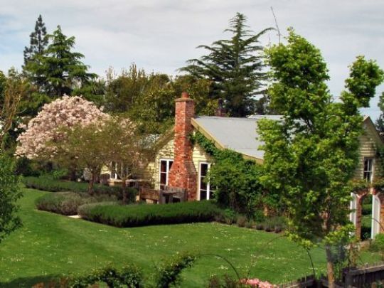
Tisbury Cottage is one of five adjacent roadside cottages whose northern boundaries were originally formed by the railway line. The west end of the Cust village was locally known, for a time, as ‘Irish town’ after several Irish families who lived there in workers cottages. This single storey vernacular cottage was constructed of weatherboard with a gabled iron roof, two brick chimneys, sash windows and a south-facing verandah spanning the front elevation. It contained four rooms leading off a central hallway. The original symmetrical façade remains, with a central front door flanked by sash windows.
Mander sold the property to J. Carter in 1898, then the Rangiora Loan and Building Society, who Carter raised a mortgage with in 1898, transferred the property to W. Thompson in 1910. A title was drawn up in March 1926 for Archibald Fidler, a Cust farmer, who retained ownership until 1968, when it was transferred to Darryl Codd, a bank manager from Lyttelton, and his wife. The cottage then passed through a number of shorter ownerships and was consistently occupied as a single residence. The building has been enlarged, with an extension added in the 1950s to the rear (north) and in the late 1980s or early 1990s to the eastern side of the cottage. These have resulted in an irregular T-shaped footprint and a mix of gabled and lean-to roof forms. After 1990, the fireplace and brick chimney were removed from the front room and a new fireplace and brick chimney constructed to the rear, north-west corner of the cottage. Around this time, it was given the name Tisbury Cottage. Ancillary buildings have been constructed over the years within the land parcel. More recently, a second verandah was added in 2011 to the rear of the building. The cottage remains in private residential use.
List Entry Information
Status
Listed
List Entry Status
Historic Place Category 2
Access
Private/No Public Access
List Number
5271
Date Entered
25th October 1990
Date of Effect
25th October 1990
City/District Council
Waimakariri District
Region
Canterbury Region
Extent of List Entry
Pt Rural Sec 5141 (RT CB373/299), Canterbury Land District and the building known as Tisbury Cottage thereon.
Legal description
Pt Rural Sec 5141 (RT CB373/299), Canterbury Land District
Status
Listed
List Entry Status
Historic Place Category 2
Access
Private/No Public Access
List Number
5271
Date Entered
25th October 1990
Date of Effect
25th October 1990
City/District Council
Waimakariri District
Region
Canterbury Region
Extent of List Entry
Pt Rural Sec 5141 (RT CB373/299), Canterbury Land District and the building known as Tisbury Cottage thereon.
Legal description
Pt Rural Sec 5141 (RT CB373/299), Canterbury Land District
Construction Details
Start Year
1886
startYearCirca
Type
Original Construction
startYearCirca
Type
Addition
Description
rear (northern) extension added
Period
1950s
startYearCirca
Type
Addition
Description
house re-piled and eastern extension added
Period
1980s
Start Year
2011
Type
Addition
Description
Verandah to rear of house (4m x 1m)
Construction Details
Start Year
1886
startYearCirca
Type
Original Construction
startYearCirca
Type
Addition
Description
rear (northern) extension added
Period
1950s
startYearCirca
Type
Addition
Description
house re-piled and eastern extension added
Period
1980s
Start Year
2011
Type
Addition
Description
Verandah to rear of house (4m x 1m)
Historical and Associated Iwi / Hapū / Whānau
Completion Date
19th May 2022
Report Written By
Arlene Baird
Other Information
This place was identified as significant under previous legislation with different information requirements. It remains significant under the current legislation. There is opportunity under our legislation and policies to add to this information. Further information about this place may be available from the Southern Regional Office of Heritage New Zealand Pouhere Taonga. Please note that entry on the New Zealand Heritage List/Rarangi Korero identifies only the heritage values of the property concerned, and should not be construed as advice on the state of the property, or as a comment of its soundness or safety, including in regard to earthquake risk, safety in the event of fire, or insanitary conditions.
Historical and Associated Iwi / Hapū / Whānau
Completion Date
19th May 2022
Report Written By
Arlene Baird
Other Information
This place was identified as significant under previous legislation with different information requirements. It remains significant under the current legislation. There is opportunity under our legislation and policies to add to this information. Further information about this place may be available from the Southern Regional Office of Heritage New Zealand Pouhere Taonga. Please note that entry on the New Zealand Heritage List/Rarangi Korero identifies only the heritage values of the property concerned, and should not be construed as advice on the state of the property, or as a comment of its soundness or safety, including in regard to earthquake risk, safety in the event of fire, or insanitary conditions.
Current Usages
Uses: Accommodation
Specific Usage: House
Former Usages
General Usage: Accommodation
Specific Usage: House
Current Usages
Uses: Accommodation
Specific Usage: House
Former Usages
General Usage: Accommodation
Specific Usage: House
Location
Sign up to hear more
Get the latest heritage news, features and events delivered
straight to your inbox.
