

The Waitangi Treaty Grounds encompass a landscape of great traditional importance. It contains sites linked with Maikuku, a granddaughter of Rāhiri - the founding ancestor of Ngāpuhi, which is New Zealand’s largest tribal group. Prior to European arrival, Waitangi was a place of seasonal gathering for the Ngāpuhi hapū, Ngāti Rāhiri, who are direct descendants of Maikuku. In 1814, the Ngāti Rāhiri rangatira, Waraki, permitted the early Church Missionary Society (CMS) member, William Hall, to hold 50 acres on the site of the current Treaty Grounds. This formed one of the earliest recorded land agreements between Māori and Pākehā in New Zealand. Hall’s agricultural ventures also constituted one of the country’s first European-style farms.
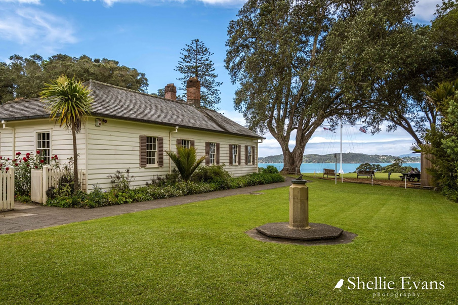
In 1833-4, James Busby erected New Zealand’s first government building on the site, having been appointed as a British Resident in Pēwhairangi / the Bay of Islands. His role involved acting as intermediary between Māori and Pākehā at a time when the commercial interests of both local rangatira and the British Empire required harmonious relations. In 1834, a gathering of Northern rangatira outside the residence chose New Zealand’s first national flag, Te Kara. The following year, a further gathering of rangatira signed He Whakaputanga o te Rangatiratanga o Nu Tirene / The Declaration of the Independence of New Zealand, which requested that the British monarch act as a matua (guardian or protector) against threats to their mana in return for their protection of British subjects. Five years later, following a British decision to organise the integration of New Zealand as a colonial possession, a treaty between Māori and the Crown was drafted. On 6 February 1840, in a tent on the lawn of Busby’s house, Te Tiriti o Waitangi / The Treaty of Waitangi was signed by a number of rangatira following vigorous discussion. Although not all Māori leaders assented, other signings ensued throughout the country. In May 1840, the country’s first governor, William Hobson, declared British sovereignty over New Zealand, making it the first island-group in the Pacific to come under formal European control.
For much of the rest of the nineteenth century, as European settlement expanded, the Waitangi estate was occupied by Busby and his family. Plantings established by him, including some from the 1830s, still survive. After a period of neglect and recognising the historic value of the site, the estate was gifted to the nation in 1932 by the Governor-General and his wife, Lord Charles and Lady Elaine Bledisloe. In 1934, the first national gathering at Waitangi occurred, and the place also formed a major focus for centennial celebrations in 1940, when structures such as Te Whare Rūnanga and the Hobson Memorial were unveiled. In the 1970s and 1980s, at a time of further Māori cultural renaissance and protests over land rights, other notable structures were erected, including a visitor centre by the renowned Māori architect, John Scott. The latter combines both Māori and Pākehā cultural influences. The Waitangi Treaty Grounds continue to be pivotal in debates about New Zealand’s unique identity and sense of nationhood, and strongly reflect the evolution of this discussion.
List Entry Information
Status
Listed
List Entry Status
Historic Place Category 1
Access
Able to Visit
List Number
6
Date Entered
23rd June 1983
Date of Effect
19th October 2015
City/District Council
Far North District
Region
Northland Region
Extent of List Entry
Extent includes part of the land described as Lot 1 DP 326610 (RT 108096), North Auckland Land District, and the buildings and structures associated with Waitangi Treaty Grounds thereon, including the Treaty House, Flagstaff, Te Whare Rūnanga, Hobson Memorial, Whare Waka - Te Korowai o Maikuku and the Waitangi Visitor Centre Te Whare Manuhiri o Waitangi. Extent also includes Maikuku’s seat and significant plantings, including two rows of cabbage trees, associated totara trees, fig trees, a Norfolk Island pine, a pohutukawa tree, a plane, an elm, an oak, a walnut, a camphor laurel, two camellia trees, a bamboo plant, and commemorative trees planted from 1932 onwards. Extent excludes the buildings known as the Caretaker’s Cottage and Staff Accommodation.
Legal description
Lot 1 DP 326610 (RT 108096), North Auckland Land District
Location Description
NZTM Easting: 1698432.0 NZTM Northing: 6096943.5 (Readings mark the approximate position of the current flagstaff.)
Why is this place significant?
Cultural Significance
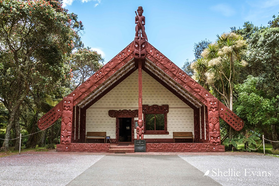
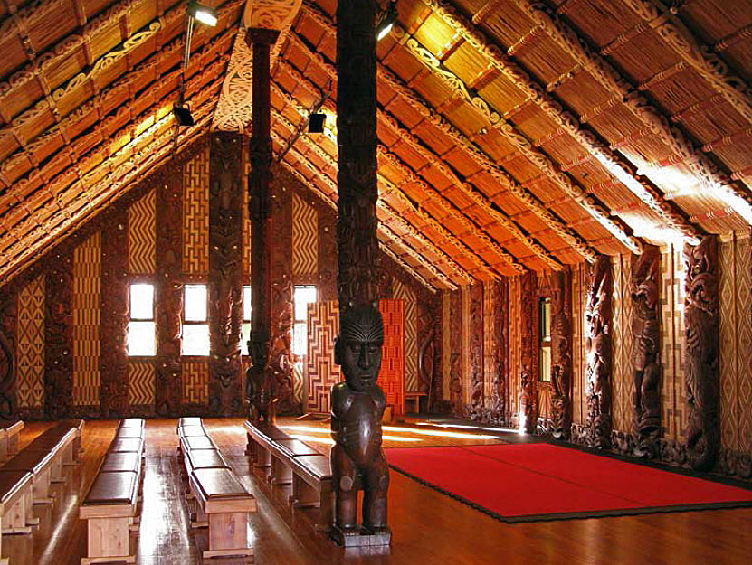
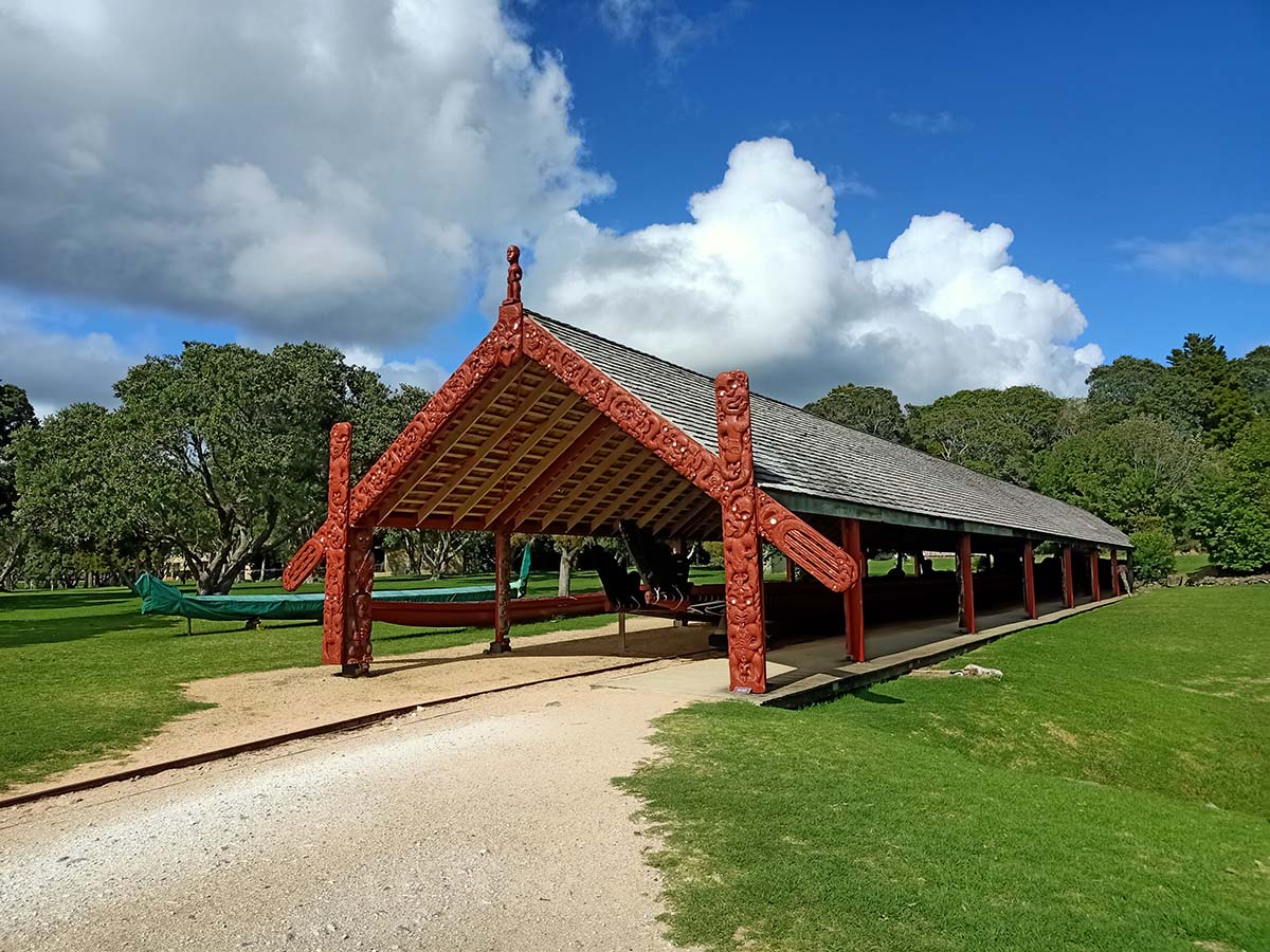
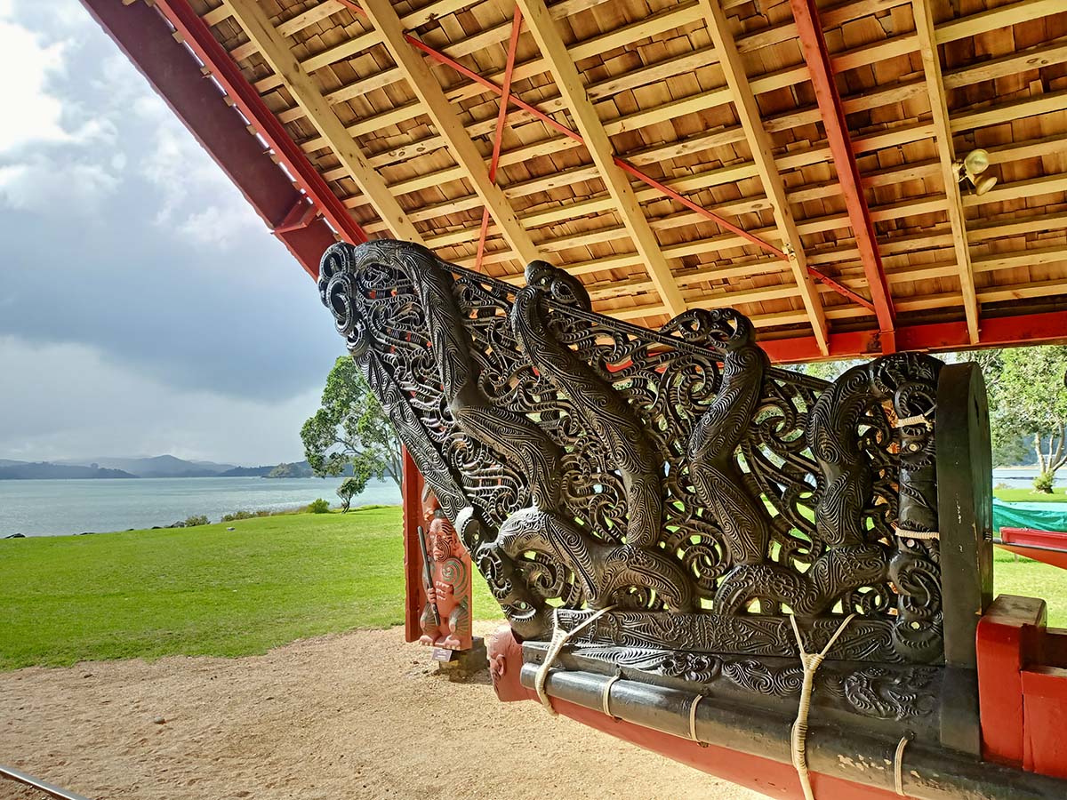
Cultural Significance or Value The place has strong cultural importance for its ability to reflect the connections and relationships, past and ongoing, between Māori and Pākehā peoples in New Zealand. In this respect, it can be considered the most symbolic site in the country. It forms a showcase for aspects of New Zealand culture, including bicultural identity. It strongly reflects the origins of modern New Zealand in both Māori and European culture. The place has cultural value for its role in reflecting New Zealand’s nationhood. The place has significance for the extent to which it reflects changing views of national identity. It reflects earlier emphasis on connections with the British Empire. More recent developments on the site express pride in New Zealand’s unique culture. Social Significance or Value The place has strong social significance for New Zealanders as a primary site for the ongoing commemoration of the Te Tiriti o Waitangi / The Treaty of Waitangi, a founding document for New Zealand as a modern nation state. Annual commemorations have been held at the site since the 1940s. The anniversary of the date of the first signing on 6 February 1840, Waitangi Day, is a national holiday. The place draws people from all over the country and overseas, who wish to learn more about Te Tiriti o Waitangi / The Treaty of Waitangi, or the place where it was first signed. It also draws people for other reasons, including recreation and the debate of matters of current political interest. The site is held in trust by the Waitangi National Trust Board as a place of historic interest, recreation, enjoyment, and benefit for the people of New Zealand. Spiritual Significance or Value The place has spiritual significance for including a recognised wahi tapu at Ruarangi. Other parts of the place have been regarded as sacred for their connections with the signing of Te Tiriti o Waitangi / The Treaty of Waitangi. The foundation stone of Te Whare Rūnanga refers to Te Paepae Tapu O Te Tiriti o Waitangi - the sacred threshold of the Treaty of Waitangi. Many in Te Ao Māori have seen the treaty, and the place where it was first signed, as representing a sacred covenant. For similar reasons, influential Pākehā such as Vernon Reed have also considered the place to be a sacred or spiritual site. Traditional Significance or Value The place has traditional significance for its close connections with important tūpuna including Maikuku, the granddaughter of Rāhiri, Ngāpuhi’s founding ancestor. Maikuku is linked with a cave, Te Ana o Maikuku, the house Ruarangi and the stone known as Maikuku’s seat. Traditional accounts hold that a taniwha lives in the waters of Te Ana o Maikuku. Through Maikuku and her husband Hua, the place is linked with many hapū of Ngāpuhi. This includes Ngāti Rāhiri, founded by Maikuku and Hua’s eldest son, Te Rā. The place is additionally of significance for its connections with important tūpuna who signed or debated Te Tiriti o Waitangi / The Treaty of Waitangi at the site, or took part in other notable related events in the grounds, including choosing the first national flag, Te Kara, and/or signing He Whakaputanga o te Rangatiratanga o Nu Tirene / The Declaration of the Independence of New Zealand. The place also has traditional significance as a repository of knowledge about tūpuna for iwi throughout New Zealand. Te Whare Rūnanga and the whare waka Te Korowai o Maikuku contain carvings that depict notable ancestors. The carved ridge pole of the porch in Te Whare Rūnanga tells the Māori creation story.
Historic Significance
Historical Significance or Value The place has strong historical importance for its connections with events that are central to New Zealand’s constitutional history and emergence as a nation state. These include the choosing by Northern rangatira of New Zealand’s first national flag, Te Kara, in 1834; the main signing of He Whakaputanga o te Rangatiratanga o Nu Tirene / The Declaration of the Independence of New Zealand by rangatira in 1835; and the first signing of Te Tiriti o Waitangi / The Treaty of Waitangi in February 1840. Drafting the treaty also partly took place on the site. The place is also of importance for its connections with the large number of notable individuals who are associated with all or some of these events. These include the many rangatira who took part, such as Te Kēmara, Tāmati Waka Nene and Hōne Heke. They also include the first British Resident, James Busby; the first Governor, William Hobson; and numerous missionary figures including Henry Williams and Jean Baptiste Pompallier. The place has additional importance for its connections with a wide variety of other events that reflect relationships between peoples, including the first recorded land agreements between Māori and Pākehā in New Zealand; one of the first European-style farms in the country; taua muru expeditions, including those between Māori; and the Northern War of 1845-6. It has value for its connections with the history of Ngāpuhi prior to European arrival. It particularly reflects the lives of James Busby and his family, who occupied the site until the 1880s; and the evolving history of the commemoration of Te Tiriti o Waitangi / The Treaty of Waitangi. It has notable links with Lord and Lady Bledisloe, who gifted the site to the nation in 1932, and the Waitangi National Trust Board and its members, which have included Vernon Reed and Sir Apirana Ngata. The Waitangi commemoration in 1940 formed a major part of the country’s centennial celebrations. Waitangi is closely linked with the history of political debate and protest in New Zealand, especially since the 1970s. The place also has historical value for its associations with the history of heritage conservation in New Zealand, being the country’s first national monument and the site of major projects to display and promote heritage to the public in the 1930s and 1980s.
Physical Significance
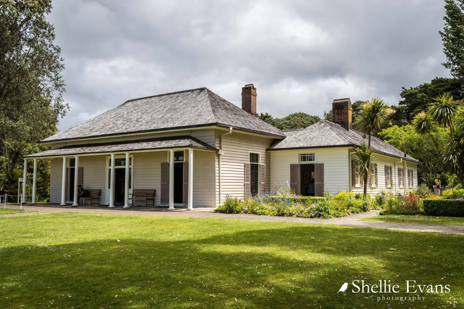
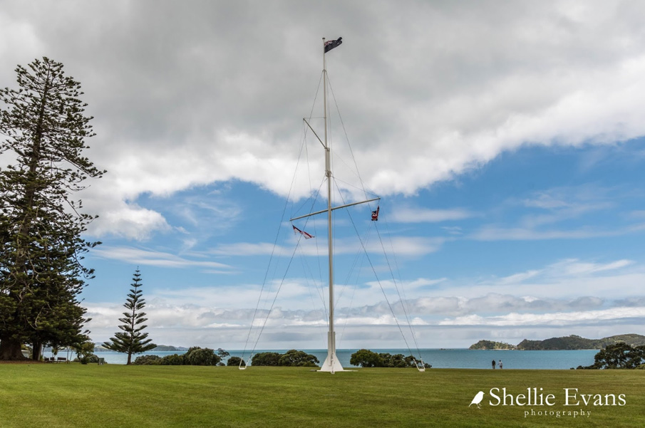
Aesthetic Significance or Value The place has aesthetic value as a visually-distinctive historic landscape. Its significance is enhanced by its setting in the Bay of Islands, including its direct proximity to the waters of the Bay and the presence of native bush. The place contains a wide variety of distinctive features, many of which have aesthetic qualities in their own right. These elements include the simplicity of the Georgian design of the Treaty House; the impressive ornamentation of Te Whare Rūnanga and whare waka; the unusual nature and visibility of the flagstaff; the visual qualities of John Scott’s design of the Waitangi Visitor Centre / Te Whare Manuhiri o Waitangi; and the sensory atmosphere derived from early plantings and features such as Maikuku’s seat. Archaeological Significance or Value The site is an important archaeological landscape, retaining features that reflect Māori occupation of the place before European arrival; very early contact between Māori and Pākehā in New Zealand; and more recent developments in the nineteenth century and later that reflect the growth of European-style settlement in the region, and approaches to conservation and commemoration from the early twentieth century onwards. Archaeological remains linked with the period of early contact between Māori and Pākeha encompass above- and below-ground remnants associated with the British Resident, James Busby, from 1833 onwards - including notable parts of the 1833-4 residency building. Significant remains also include remnants of extensive and rare colonial agricultural systems in the form of extremely well-preserved ridge-and-furrow, particularly to the north of the Treaty House. The place also encompasses historic plantings that reflect horticultural and other activity. The place also retains evidence of Māori occupation that probably pre-dates European arrival; material linked with very early missionary activity in New Zealand in 1814-15 - which was one of New Zealand’s first European-style farms; and activity linked with military occupation during the Northern War of 1845-6. Architectural Significance or Value The place has architectural significance for incorporating remnants of one of the oldest surviving standing buildings in New Zealand, and the country’s earliest remaining residence that was not created by or for missionaries. Initially known as the British Residency (and now known as the Treaty House), this is one of few structures left in New Zealand that pre-dates the signing of Te Tiriti o Waitangi / The Treaty of Waitangi, an event with which it is intrinsically linked. It is architecturally significant for its ability to demonstrate aspects of colonial Georgian form, layout and appearance, and is an important surviving design by the Colonial Architect of New South Wales, Ambrose Hallen: it is his only known work in New Zealand. It is also the only currently known building in New Zealand that has involved the noted Australian colonial architect, John Verge, in its design. The exceptionally well-preserved Te Whare Rūnanga has been considered architecturally notable for its ability to demonstrate the approaches developed by the Rotorua School of Māori Arts and Crafts in the early twentieth century, which combined traditional Māori, twentieth-century Māori and European elements. The place also has architectural significance for its close connections with the revival of Māori architectural arts at that time, and the design input of individuals who played a key role in that revival such as Sir Apirana Ngata. The Waitangi Visitor Centre / Te Whare Manuhiri o Waitangi has architectural value as an important example of a public building designed by the significant New Zealand architect John Scott. Combining Māori and Pākehā architectural elements, its importance is enhanced through its association with the Waitangi site, and its symbolic fusion of separate traditions. Significance extends to its setting in native bush, which formed part of the original design concept. The building contains many significant features, including stained glass windows, and notable carvings such as the lintel over the main doors by Para Matchitt and a carved post in the auditorium by Joseph Eparara. Technological Significance or Value The Treaty House has technological significance for incorporating the remnants of New Zealand‘s oldest surviving prefabricated building. Prefabrication was an important and effective means of transferring colonial ideas about construction methods and building design in the period of early contact between Māori and Pākehā. Significant elements that in this instance indicate prefabrication, such as assembly marks, are visible. The frame also demonstrates other aspects of very early colonial construction techniques that form part of a long overseas tradition, such as pegged mortice and tenon joints.
Why is this place Category 1 / Category 2?
Detail Of Assessed Criteria
(a)The extent to which the place reflects important or representative aspects of New Zealand history The place has outstanding significance for the extent to which it reflects aspects of New Zealand history such as relationships and connections between Māori and Pākehā from the early 1800s to the present day – a key component of our collective history. It also has outstanding importance for reflecting significant aspects of New Zealand’s constitutional history, including the autonomy of Northern rangatira prior to 1840, New Zealand’s close connections with British government in New South Wales, and the country’s emergence as a colonial possession - all aspects of New Zealand’s trajectory as an emerging nation state. The place reflects cultural renaissance, especially among Māori in the early twentieth century, and again from the 1970s. This is shown by important manifestations of this flowering such as Te Whare Rūnanga, Te Korowai o Maikuku and the John Scott visitor centre. The place also has importance for the extent to which it demonstrates attitudes to remembering, commemoration and the past. The Waitangi Treaty Grounds site is significant for including the first building purchased as a state monument in New Zealand - the Treaty House. This affirmed colonial links with Britain as well as a growing sense of national identity. The place also strongly reflects more recent shifts in perspective as an independent nation. Its associations with New Zealand's perceptions of nationhood continue. The place is additionally significant for reflecting early European-style farming and horticulture in New Zealand. It has particular importance with regard to the history of viticulture. The latter is demonstrated by two rows of surviving cabbage trees, believed to have formed a windbreak for early vines. (b)The association of the place with events, persons, or ideas of importance in New Zealand history The place has outstanding significance for the strength of its associations with the first signing of Te Tiriti o Waitangi / The Treaty of Waitangi - generally regarded as New Zealand’s founding document - and other major events that led up to this occurrence. The latter include the arrival of James Busby as British Resident (1833), the choosing of New Zealand’s first national flag by Northern rangatira (1834) and the discussion and signing of He Whakaputanga o te Rangatiratanga o Nu Tirene / The Declaration of the Independence of New Zealand (1835). It can be considered internationally significant for its connections with important compacts between indigenous peoples and the major colonial power of its day. The place is closely linked with a large number of notable Northern rangatira who participated in these and related events, including Waikato, Te Kēmara, Tāmati Waka Nene and Hōne Heke. The place is especially associated with James Busby, a major figure in New Zealand’s growing connections with the outside world, and particularly Great Britain, in the early nineteenth century. Busby and his family occupied the site for almost 50 years. The place is also linked to other figures of importance in New Zealand history, including the first Governor of New Zealand, William Hobson, and notable missionaries in Pēwharangi / the Bay of Islands such as Henry Williams and Bishop Jean-Baptiste Pompallier - who were both closely connected with events surrounding Te Tiriti o Waitangi / The Treaty of Waitangi. The place has had some notable visitors including the eminent naturalist, Charles Darwin. Other notable events that the place is linked with include the early activities of Church Missionary Society missionaries in New Zealand, including early rifts reflecting differing attitudes to private enterprise; the so-called ‘Musket Wars’ of the 1820s; the Northern War of 1845-6; and attempts to create townships at an early stage in New Zealand’s colonial history – the latter through the sale of allotments at Victoria in the southern part of the site. The place also has important connections with the 1940 centennial celebrations; the Rotorua School of Arts and Crafts; notable members of the Waitangi National Trust Board including Sir Apirana Ngata; Lord and Lady Bledisloe; and numerous other politicians and Governors-General. (c)The potential of the place to provide knowledge of New Zealand history The place has special significance for its ability to provide knowledge of New Zealand history through archaeological enquiry and other physical investigation. The place retains or may retain evidence from many different periods of occupation, including pre-European Māori; use by William Hall and his companions as an early European-style farm; and settlement by James Busby and his family. The place also has potential to provide information about the history of commemoration and attitudes to heritage conservation. This can be obtained through the study of surviving commemorative features and conserved structures that in some cases have been in existence for more than 80 years. This potential is enhanced by the existence of a large quantity of primary documentary material. (d)The importance of the place to tangata whenua As the site of Ruarangi, the place has initial meaning to Ngāpuhi, especially those hapū descended from Maikuku and Hua. It has particular connections with Ngāti Rāhiri hapū of Ngāpuhi, whose ancestor Te Rā was born at Ruarangi. The place is also associated with Ngāti Kawa and Te Matarahurahu. It is an important ancestral landscape, associated with tūpuna that include those involved in the many notable events that occurred at Waitangi. The place has outstanding significance for tangata whenua due to its connections with important events such as the choosing of New Zealand’s first national flag, Te Kara, in 1834; the signing of He Whakaputanga o te Rangatiratanga o Nu Tirene / The Declaration of the Independence of New Zealand by rangatira in 1835; and the first signing of Te Tiriti o Waitangi / The Treaty of Waitangi in 1840. The place also has high significance for its wider Māori connections as expressed through Te Whare Rūnanga, Te Korowai o Maikuku and other aspects. (e)The community association with, or public esteem for the place The place has outstanding significance for its public esteem and community association. Together with the nearby Te Tii Marae, it is a major focus of annual gatherings connected with Waitangi Day on 6 February. The place is familiar to most people in New Zealand society. In the past, such gatherings have been televised. Public esteem is demonstrated by the large number of visitors that Waitangi receives, both from New Zealand and overseas. Its esteem has been enhanced by the contribution of Māori communities from throughout New Zealand, who have assisted with commemorative events at the site and the creation of taonga that include Te Whare Rūnanga. A wide variety of other groups and individuals have contributed to conservation and commemoration at the site. The community association with the place is an ongoing one as a touchstone for the nation. (f)The potential of the place for public education The place has outstanding significance for its potential for public education. Education about Te Tiriti o Waitangi / The Treaty of Waitangi and related matters form a core principle of the Waitangi National Trust Board. The place is located in a major visitor destination, and caters for large numbers of visitors from New Zealand and overseas. Public education is provided through a visitor centre, on-site interpretation and educational programmes. The place has the potential to provide education about a wide variety of historical matters, associated with a wide range of peoples, topics and time. (g)The technical accomplishment, value, or design of the place The place has outstanding significance for incorporating the remnants of the earliest building in the country with a known architectural pedigree, and the oldest surviving prefabricated building in New Zealand. This structure, now known as the Treaty House, demonstrates other important surviving aspects of early nineteenth-century design and technology. It has been referred to as one of relatively few examples of Palladian architectural composition, incorporating balanced north and south wings. The place is also collectively important for the design of Te Whare Rūnanga, a significant structure linked with the early twentieth-century revival of Māori arts and crafts that is unique for having carvings connected with a very wide variety of tribal groupings; Te Korowai o Maikuku, a rare example of a whare waka, which houses the war canoe Ngātokimatawhaorua; and the John Scott-designed Visitor Centre, which reflects both Māori and European influences. The place is also of special value for surviving aspects of its pre- and early colonial landscape design, reflected in the location of the Treaty House, surviving tree plantings and extensive ridge-and-furrow. The place is additionally notable for its connections with important and ground-breaking architectural conservation projects, including the work undertaken on the Treaty House in 1933 by W. H. Gummer and W. M. Page - one of the earliest major state restorations of a historic building in the country. Subsequent conservation under the supervision of the Australian architect, Clive Lucas, in 1989-90 was also notable for its attempts to more accurately reflect aspects of its early form through careful physical investigation and extensive documentary research. (h)The symbolic or commemorative value of the place The place has outstanding significance as the most symbolically important site in New Zealand. It particularly symbolises New Zealand’s unique origins and identity as a nation state. The place has outstanding commemorative value, connected with 6 February, Waitangi Day, being an annual national holiday. It is symbolically valuable to both Māori and Pākehā for its links with the aims and aspirations of Te Tiriti o Waitangi / The Treaty of Waitangi. The place is itself an outstanding commemorative landscape of historical and cultural value associated with remembering the events surrounding Te Tiriti o Waitangi / The Treaty of Waitangi. Through its structures, commemorative plantings and other features, it commemorates both Māori and Pākehā partners – including iwi throughout the country and the Crown. Its symbolic and commemorative importance extends to its role as a place of debate and protest. (i)The importance of identifying historic places known to date from an early period of New Zealand settlement The place has outstanding significance for incorporating the remnants of one of the oldest surviving standing buildings in New Zealand, contemporary plantings and potentially other elements of a similar period that dates to a phase of early contact between Māori and Pākehā in New Zealand. The place is also associated with some of the earliest known contact between Māori and European missionaries. It occupies the site of one of the earliest recorded land agreements between Māori and Pākehā in New Zealand, and one of the earliest attempted European-style farms, created in 1814. (j)The importance of identifying rare types of historic places The place has special significance for incorporating the only surviving example of a colonial British Residency in New Zealand. The latter is one of very few nineteenth-century buildings that were designed and built as an official government house, and reflects contemporary attitudes about government authority. (k)The extent to which the place forms part of a wider historical and cultural area The place has special significance as part of a wider landscape of historical, archaeological and cultural importance. Recorded archaeological sites attest to widespread Māori activity in the area. Other places of traditional importance to Māori are located nearby. Visible elements of the colonial landscape extend beyond the boundary of the historic place, especially to the north. A broader landscape associated with Te Tiriti o Waitangi / The Treaty of Waitangi and associated events, lies to the south of the Waitangi River. This includes Te Tou Rangatira and the Treaty Monument at Te Tii Marae. The churchyard at Paihia where Busby read the ‘King’s letter’ also survives. The place is connected by water to a more extensive historical and cultural landscape in Pēwhairangi / the Bay of Islands, which contains other important sites linked with the developing contact and relationships between Māori and Pākehā in New Zealand during the early 1800s - such as Rangihoua, Kororāreka / Russell, and Kerikeri - and before. Summary of Significance or Values The Waitangi Treaty Grounds has outstanding significance as the most symbolically important place in New Zealand. It is a focal commemorative landscape associated with remembering the events surrounding Te Tiriti o Waitangi / The Treaty of Waitangi - New Zealand’s founding document. The place is an important ancestral landscape and also has outstanding significance for tangata whenua due to its connections with important events such as the choosing of New Zealand’s first national flag, Te Kara, in 1834; the signing of He Whakaputanga o te Rangatiratanga o Nu Tirene / The Declaration of the Independence of New Zealand by rangatira in 1835; and the first signing of Te Tiriti o Waitangi / The Treaty of Waitangi in 1840. The Waitangi Treaty Grounds enjoys a similar level of more general public esteem and community association for reasons that also encompass its strong connections with the signing and commemoration of Te Tiriti o Waitangi / The Treaty of Waitangi. It has outstanding potential for public education, especially about Te Tiriti o Waitangi / The Treaty of Waitangi and related matters. The place also has outstanding importance for the extent to which it reflects aspects of New Zealand history such as relationships and connections between Māori and Pākehā from the early 1800s to the present day - a key component of our collective history. The place has outstanding value for reflecting significant aspects of New Zealand’s constitutional history, including the autonomy of rangatira, New Zealand’s close connections with British government in New South Wales, and the country’s emergence as a colonial possession. It is also outstandingly significant for incorporating the remnants of one of the oldest surviving buildings in New Zealand - which is also the earliest building in the country with a known architectural pedigree and New Zealand’s oldest surviving prefabricated structure. It has outstanding significance for incorporating the remnants of contemporary plantings and potentially other elements of a similar period that dates to a phase of early prolonged contact between Māori and Pākehā in New Zealand. The place has special significance for its ability to provide knowledge of New Zealand history through archaeological enquiry and other physical investigation. This is enhanced as part of a wider landscape of historical, archaeological and cultural importance. It is also of special significance for incorporating the only surviving example of a colonial British Residency in New Zealand. The Waitangi Treaty Grounds is a very rare example of a historic place that qualifies as special or outstanding under all criteria between a and k under s66 (3) of the Heritage New Zealand Pouhere Taonga Act 2014.
Why is this place significant?
Cultural Significance
Cultural Significance or Value The place has strong cultural importance for its ability to reflect the connections and relationships, past and ongoing, between Māori and Pākehā peoples in New Zealand. In this respect, it can be considered the most symbolic site in the country. It forms a showcase for aspects of New Zealand culture, including bicultural identity. It strongly reflects the origins of modern New Zealand in both Māori and European culture. The place has cultural value for its role in reflecting New Zealand’s nationhood. The place has significance for the extent to which it reflects changing views of national identity. It reflects earlier emphasis on connections with the British Empire. More recent developments on the site express pride in New Zealand’s unique culture. Social Significance or Value The place has strong social significance for New Zealanders as a primary site for the ongoing commemoration of the Te Tiriti o Waitangi / The Treaty of Waitangi, a founding document for New Zealand as a modern nation state. Annual commemorations have been held at the site since the 1940s. The anniversary of the date of the first signing on 6 February 1840, Waitangi Day, is a national holiday. The place draws people from all over the country and overseas, who wish to learn more about Te Tiriti o Waitangi / The Treaty of Waitangi, or the place where it was first signed. It also draws people for other reasons, including recreation and the debate of matters of current political interest. The site is held in trust by the Waitangi National Trust Board as a place of historic interest, recreation, enjoyment, and benefit for the people of New Zealand. Spiritual Significance or Value The place has spiritual significance for including a recognised wahi tapu at Ruarangi. Other parts of the place have been regarded as sacred for their connections with the signing of Te Tiriti o Waitangi / The Treaty of Waitangi. The foundation stone of Te Whare Rūnanga refers to Te Paepae Tapu O Te Tiriti o Waitangi - the sacred threshold of the Treaty of Waitangi. Many in Te Ao Māori have seen the treaty, and the place where it was first signed, as representing a sacred covenant. For similar reasons, influential Pākehā such as Vernon Reed have also considered the place to be a sacred or spiritual site. Traditional Significance or Value The place has traditional significance for its close connections with important tūpuna including Maikuku, the granddaughter of Rāhiri, Ngāpuhi’s founding ancestor. Maikuku is linked with a cave, Te Ana o Maikuku, the house Ruarangi and the stone known as Maikuku’s seat. Traditional accounts hold that a taniwha lives in the waters of Te Ana o Maikuku. Through Maikuku and her husband Hua, the place is linked with many hapū of Ngāpuhi. This includes Ngāti Rāhiri, founded by Maikuku and Hua’s eldest son, Te Rā. The place is additionally of significance for its connections with important tūpuna who signed or debated Te Tiriti o Waitangi / The Treaty of Waitangi at the site, or took part in other notable related events in the grounds, including choosing the first national flag, Te Kara, and/or signing He Whakaputanga o te Rangatiratanga o Nu Tirene / The Declaration of the Independence of New Zealand. The place also has traditional significance as a repository of knowledge about tūpuna for iwi throughout New Zealand. Te Whare Rūnanga and the whare waka Te Korowai o Maikuku contain carvings that depict notable ancestors. The carved ridge pole of the porch in Te Whare Rūnanga tells the Māori creation story.
Historic Significance
Historical Significance or Value The place has strong historical importance for its connections with events that are central to New Zealand’s constitutional history and emergence as a nation state. These include the choosing by Northern rangatira of New Zealand’s first national flag, Te Kara, in 1834; the main signing of He Whakaputanga o te Rangatiratanga o Nu Tirene / The Declaration of the Independence of New Zealand by rangatira in 1835; and the first signing of Te Tiriti o Waitangi / The Treaty of Waitangi in February 1840. Drafting the treaty also partly took place on the site. The place is also of importance for its connections with the large number of notable individuals who are associated with all or some of these events. These include the many rangatira who took part, such as Te Kēmara, Tāmati Waka Nene and Hōne Heke. They also include the first British Resident, James Busby; the first Governor, William Hobson; and numerous missionary figures including Henry Williams and Jean Baptiste Pompallier. The place has additional importance for its connections with a wide variety of other events that reflect relationships between peoples, including the first recorded land agreements between Māori and Pākehā in New Zealand; one of the first European-style farms in the country; taua muru expeditions, including those between Māori; and the Northern War of 1845-6. It has value for its connections with the history of Ngāpuhi prior to European arrival. It particularly reflects the lives of James Busby and his family, who occupied the site until the 1880s; and the evolving history of the commemoration of Te Tiriti o Waitangi / The Treaty of Waitangi. It has notable links with Lord and Lady Bledisloe, who gifted the site to the nation in 1932, and the Waitangi National Trust Board and its members, which have included Vernon Reed and Sir Apirana Ngata. The Waitangi commemoration in 1940 formed a major part of the country’s centennial celebrations. Waitangi is closely linked with the history of political debate and protest in New Zealand, especially since the 1970s. The place also has historical value for its associations with the history of heritage conservation in New Zealand, being the country’s first national monument and the site of major projects to display and promote heritage to the public in the 1930s and 1980s.
Physical Significance
Aesthetic Significance or Value The place has aesthetic value as a visually-distinctive historic landscape. Its significance is enhanced by its setting in the Bay of Islands, including its direct proximity to the waters of the Bay and the presence of native bush. The place contains a wide variety of distinctive features, many of which have aesthetic qualities in their own right. These elements include the simplicity of the Georgian design of the Treaty House; the impressive ornamentation of Te Whare Rūnanga and whare waka; the unusual nature and visibility of the flagstaff; the visual qualities of John Scott’s design of the Waitangi Visitor Centre / Te Whare Manuhiri o Waitangi; and the sensory atmosphere derived from early plantings and features such as Maikuku’s seat. Archaeological Significance or Value The site is an important archaeological landscape, retaining features that reflect Māori occupation of the place before European arrival; very early contact between Māori and Pākehā in New Zealand; and more recent developments in the nineteenth century and later that reflect the growth of European-style settlement in the region, and approaches to conservation and commemoration from the early twentieth century onwards. Archaeological remains linked with the period of early contact between Māori and Pākeha encompass above- and below-ground remnants associated with the British Resident, James Busby, from 1833 onwards - including notable parts of the 1833-4 residency building. Significant remains also include remnants of extensive and rare colonial agricultural systems in the form of extremely well-preserved ridge-and-furrow, particularly to the north of the Treaty House. The place also encompasses historic plantings that reflect horticultural and other activity. The place also retains evidence of Māori occupation that probably pre-dates European arrival; material linked with very early missionary activity in New Zealand in 1814-15 - which was one of New Zealand’s first European-style farms; and activity linked with military occupation during the Northern War of 1845-6. Architectural Significance or Value The place has architectural significance for incorporating remnants of one of the oldest surviving standing buildings in New Zealand, and the country’s earliest remaining residence that was not created by or for missionaries. Initially known as the British Residency (and now known as the Treaty House), this is one of few structures left in New Zealand that pre-dates the signing of Te Tiriti o Waitangi / The Treaty of Waitangi, an event with which it is intrinsically linked. It is architecturally significant for its ability to demonstrate aspects of colonial Georgian form, layout and appearance, and is an important surviving design by the Colonial Architect of New South Wales, Ambrose Hallen: it is his only known work in New Zealand. It is also the only currently known building in New Zealand that has involved the noted Australian colonial architect, John Verge, in its design. The exceptionally well-preserved Te Whare Rūnanga has been considered architecturally notable for its ability to demonstrate the approaches developed by the Rotorua School of Māori Arts and Crafts in the early twentieth century, which combined traditional Māori, twentieth-century Māori and European elements. The place also has architectural significance for its close connections with the revival of Māori architectural arts at that time, and the design input of individuals who played a key role in that revival such as Sir Apirana Ngata. The Waitangi Visitor Centre / Te Whare Manuhiri o Waitangi has architectural value as an important example of a public building designed by the significant New Zealand architect John Scott. Combining Māori and Pākehā architectural elements, its importance is enhanced through its association with the Waitangi site, and its symbolic fusion of separate traditions. Significance extends to its setting in native bush, which formed part of the original design concept. The building contains many significant features, including stained glass windows, and notable carvings such as the lintel over the main doors by Para Matchitt and a carved post in the auditorium by Joseph Eparara. Technological Significance or Value The Treaty House has technological significance for incorporating the remnants of New Zealand‘s oldest surviving prefabricated building. Prefabrication was an important and effective means of transferring colonial ideas about construction methods and building design in the period of early contact between Māori and Pākehā. Significant elements that in this instance indicate prefabrication, such as assembly marks, are visible. The frame also demonstrates other aspects of very early colonial construction techniques that form part of a long overseas tradition, such as pegged mortice and tenon joints.
Why is this place Category 1 / Category 2?
Detail Of Assessed Criteria
(a)The extent to which the place reflects important or representative aspects of New Zealand history The place has outstanding significance for the extent to which it reflects aspects of New Zealand history such as relationships and connections between Māori and Pākehā from the early 1800s to the present day – a key component of our collective history. It also has outstanding importance for reflecting significant aspects of New Zealand’s constitutional history, including the autonomy of Northern rangatira prior to 1840, New Zealand’s close connections with British government in New South Wales, and the country’s emergence as a colonial possession - all aspects of New Zealand’s trajectory as an emerging nation state. The place reflects cultural renaissance, especially among Māori in the early twentieth century, and again from the 1970s. This is shown by important manifestations of this flowering such as Te Whare Rūnanga, Te Korowai o Maikuku and the John Scott visitor centre. The place also has importance for the extent to which it demonstrates attitudes to remembering, commemoration and the past. The Waitangi Treaty Grounds site is significant for including the first building purchased as a state monument in New Zealand - the Treaty House. This affirmed colonial links with Britain as well as a growing sense of national identity. The place also strongly reflects more recent shifts in perspective as an independent nation. Its associations with New Zealand's perceptions of nationhood continue. The place is additionally significant for reflecting early European-style farming and horticulture in New Zealand. It has particular importance with regard to the history of viticulture. The latter is demonstrated by two rows of surviving cabbage trees, believed to have formed a windbreak for early vines. (b)The association of the place with events, persons, or ideas of importance in New Zealand history The place has outstanding significance for the strength of its associations with the first signing of Te Tiriti o Waitangi / The Treaty of Waitangi - generally regarded as New Zealand’s founding document - and other major events that led up to this occurrence. The latter include the arrival of James Busby as British Resident (1833), the choosing of New Zealand’s first national flag by Northern rangatira (1834) and the discussion and signing of He Whakaputanga o te Rangatiratanga o Nu Tirene / The Declaration of the Independence of New Zealand (1835). It can be considered internationally significant for its connections with important compacts between indigenous peoples and the major colonial power of its day. The place is closely linked with a large number of notable Northern rangatira who participated in these and related events, including Waikato, Te Kēmara, Tāmati Waka Nene and Hōne Heke. The place is especially associated with James Busby, a major figure in New Zealand’s growing connections with the outside world, and particularly Great Britain, in the early nineteenth century. Busby and his family occupied the site for almost 50 years. The place is also linked to other figures of importance in New Zealand history, including the first Governor of New Zealand, William Hobson, and notable missionaries in Pēwharangi / the Bay of Islands such as Henry Williams and Bishop Jean-Baptiste Pompallier - who were both closely connected with events surrounding Te Tiriti o Waitangi / The Treaty of Waitangi. The place has had some notable visitors including the eminent naturalist, Charles Darwin. Other notable events that the place is linked with include the early activities of Church Missionary Society missionaries in New Zealand, including early rifts reflecting differing attitudes to private enterprise; the so-called ‘Musket Wars’ of the 1820s; the Northern War of 1845-6; and attempts to create townships at an early stage in New Zealand’s colonial history – the latter through the sale of allotments at Victoria in the southern part of the site. The place also has important connections with the 1940 centennial celebrations; the Rotorua School of Arts and Crafts; notable members of the Waitangi National Trust Board including Sir Apirana Ngata; Lord and Lady Bledisloe; and numerous other politicians and Governors-General. (c)The potential of the place to provide knowledge of New Zealand history The place has special significance for its ability to provide knowledge of New Zealand history through archaeological enquiry and other physical investigation. The place retains or may retain evidence from many different periods of occupation, including pre-European Māori; use by William Hall and his companions as an early European-style farm; and settlement by James Busby and his family. The place also has potential to provide information about the history of commemoration and attitudes to heritage conservation. This can be obtained through the study of surviving commemorative features and conserved structures that in some cases have been in existence for more than 80 years. This potential is enhanced by the existence of a large quantity of primary documentary material. (d)The importance of the place to tangata whenua As the site of Ruarangi, the place has initial meaning to Ngāpuhi, especially those hapū descended from Maikuku and Hua. It has particular connections with Ngāti Rāhiri hapū of Ngāpuhi, whose ancestor Te Rā was born at Ruarangi. The place is also associated with Ngāti Kawa and Te Matarahurahu. It is an important ancestral landscape, associated with tūpuna that include those involved in the many notable events that occurred at Waitangi. The place has outstanding significance for tangata whenua due to its connections with important events such as the choosing of New Zealand’s first national flag, Te Kara, in 1834; the signing of He Whakaputanga o te Rangatiratanga o Nu Tirene / The Declaration of the Independence of New Zealand by rangatira in 1835; and the first signing of Te Tiriti o Waitangi / The Treaty of Waitangi in 1840. The place also has high significance for its wider Māori connections as expressed through Te Whare Rūnanga, Te Korowai o Maikuku and other aspects. (e)The community association with, or public esteem for the place The place has outstanding significance for its public esteem and community association. Together with the nearby Te Tii Marae, it is a major focus of annual gatherings connected with Waitangi Day on 6 February. The place is familiar to most people in New Zealand society. In the past, such gatherings have been televised. Public esteem is demonstrated by the large number of visitors that Waitangi receives, both from New Zealand and overseas. Its esteem has been enhanced by the contribution of Māori communities from throughout New Zealand, who have assisted with commemorative events at the site and the creation of taonga that include Te Whare Rūnanga. A wide variety of other groups and individuals have contributed to conservation and commemoration at the site. The community association with the place is an ongoing one as a touchstone for the nation. (f)The potential of the place for public education The place has outstanding significance for its potential for public education. Education about Te Tiriti o Waitangi / The Treaty of Waitangi and related matters form a core principle of the Waitangi National Trust Board. The place is located in a major visitor destination, and caters for large numbers of visitors from New Zealand and overseas. Public education is provided through a visitor centre, on-site interpretation and educational programmes. The place has the potential to provide education about a wide variety of historical matters, associated with a wide range of peoples, topics and time. (g)The technical accomplishment, value, or design of the place The place has outstanding significance for incorporating the remnants of the earliest building in the country with a known architectural pedigree, and the oldest surviving prefabricated building in New Zealand. This structure, now known as the Treaty House, demonstrates other important surviving aspects of early nineteenth-century design and technology. It has been referred to as one of relatively few examples of Palladian architectural composition, incorporating balanced north and south wings. The place is also collectively important for the design of Te Whare Rūnanga, a significant structure linked with the early twentieth-century revival of Māori arts and crafts that is unique for having carvings connected with a very wide variety of tribal groupings; Te Korowai o Maikuku, a rare example of a whare waka, which houses the war canoe Ngātokimatawhaorua; and the John Scott-designed Visitor Centre, which reflects both Māori and European influences. The place is also of special value for surviving aspects of its pre- and early colonial landscape design, reflected in the location of the Treaty House, surviving tree plantings and extensive ridge-and-furrow. The place is additionally notable for its connections with important and ground-breaking architectural conservation projects, including the work undertaken on the Treaty House in 1933 by W. H. Gummer and W. M. Page - one of the earliest major state restorations of a historic building in the country. Subsequent conservation under the supervision of the Australian architect, Clive Lucas, in 1989-90 was also notable for its attempts to more accurately reflect aspects of its early form through careful physical investigation and extensive documentary research. (h)The symbolic or commemorative value of the place The place has outstanding significance as the most symbolically important site in New Zealand. It particularly symbolises New Zealand’s unique origins and identity as a nation state. The place has outstanding commemorative value, connected with 6 February, Waitangi Day, being an annual national holiday. It is symbolically valuable to both Māori and Pākehā for its links with the aims and aspirations of Te Tiriti o Waitangi / The Treaty of Waitangi. The place is itself an outstanding commemorative landscape of historical and cultural value associated with remembering the events surrounding Te Tiriti o Waitangi / The Treaty of Waitangi. Through its structures, commemorative plantings and other features, it commemorates both Māori and Pākehā partners – including iwi throughout the country and the Crown. Its symbolic and commemorative importance extends to its role as a place of debate and protest. (i)The importance of identifying historic places known to date from an early period of New Zealand settlement The place has outstanding significance for incorporating the remnants of one of the oldest surviving standing buildings in New Zealand, contemporary plantings and potentially other elements of a similar period that dates to a phase of early contact between Māori and Pākehā in New Zealand. The place is also associated with some of the earliest known contact between Māori and European missionaries. It occupies the site of one of the earliest recorded land agreements between Māori and Pākehā in New Zealand, and one of the earliest attempted European-style farms, created in 1814. (j)The importance of identifying rare types of historic places The place has special significance for incorporating the only surviving example of a colonial British Residency in New Zealand. The latter is one of very few nineteenth-century buildings that were designed and built as an official government house, and reflects contemporary attitudes about government authority. (k)The extent to which the place forms part of a wider historical and cultural area The place has special significance as part of a wider landscape of historical, archaeological and cultural importance. Recorded archaeological sites attest to widespread Māori activity in the area. Other places of traditional importance to Māori are located nearby. Visible elements of the colonial landscape extend beyond the boundary of the historic place, especially to the north. A broader landscape associated with Te Tiriti o Waitangi / The Treaty of Waitangi and associated events, lies to the south of the Waitangi River. This includes Te Tou Rangatira and the Treaty Monument at Te Tii Marae. The churchyard at Paihia where Busby read the ‘King’s letter’ also survives. The place is connected by water to a more extensive historical and cultural landscape in Pēwhairangi / the Bay of Islands, which contains other important sites linked with the developing contact and relationships between Māori and Pākehā in New Zealand during the early 1800s - such as Rangihoua, Kororāreka / Russell, and Kerikeri - and before. Summary of Significance or Values The Waitangi Treaty Grounds has outstanding significance as the most symbolically important place in New Zealand. It is a focal commemorative landscape associated with remembering the events surrounding Te Tiriti o Waitangi / The Treaty of Waitangi - New Zealand’s founding document. The place is an important ancestral landscape and also has outstanding significance for tangata whenua due to its connections with important events such as the choosing of New Zealand’s first national flag, Te Kara, in 1834; the signing of He Whakaputanga o te Rangatiratanga o Nu Tirene / The Declaration of the Independence of New Zealand by rangatira in 1835; and the first signing of Te Tiriti o Waitangi / The Treaty of Waitangi in 1840. The Waitangi Treaty Grounds enjoys a similar level of more general public esteem and community association for reasons that also encompass its strong connections with the signing and commemoration of Te Tiriti o Waitangi / The Treaty of Waitangi. It has outstanding potential for public education, especially about Te Tiriti o Waitangi / The Treaty of Waitangi and related matters. The place also has outstanding importance for the extent to which it reflects aspects of New Zealand history such as relationships and connections between Māori and Pākehā from the early 1800s to the present day - a key component of our collective history. The place has outstanding value for reflecting significant aspects of New Zealand’s constitutional history, including the autonomy of rangatira, New Zealand’s close connections with British government in New South Wales, and the country’s emergence as a colonial possession. It is also outstandingly significant for incorporating the remnants of one of the oldest surviving buildings in New Zealand - which is also the earliest building in the country with a known architectural pedigree and New Zealand’s oldest surviving prefabricated structure. It has outstanding significance for incorporating the remnants of contemporary plantings and potentially other elements of a similar period that dates to a phase of early prolonged contact between Māori and Pākehā in New Zealand. The place has special significance for its ability to provide knowledge of New Zealand history through archaeological enquiry and other physical investigation. This is enhanced as part of a wider landscape of historical, archaeological and cultural importance. It is also of special significance for incorporating the only surviving example of a colonial British Residency in New Zealand. The Waitangi Treaty Grounds is a very rare example of a historic place that qualifies as special or outstanding under all criteria between a and k under s66 (3) of the Heritage New Zealand Pouhere Taonga Act 2014.
Construction Professional
Name
Lucas, Clive
Type
Architect
Biography
No biography is currently available for this construction professional
Name
Fuller and Bullen
Type
Builder
Biography
No biography is currently available for this construction professional
Name
Ralph McComb
Type
Builder
Biography
No biography is currently available for this construction professional
Name
Capt. R. Price
Type
Designer
Biography
No biography is currently available for this construction professional
Name
Ngata, Sir Apirana Turupa
Type
Architect
Biography
Apirana Ngata (1874-1954) was educated at Wai-o-Matatini Native School, Te Aute College and Canterbury University College. In 1893 he graduated Bachelor of Arts and in 1894 he became the first Maori to graduate Master of Arts (with honours in political science). He completed a law degree in 1896 and was admitted as a barrister and solicitor in 1897. Two years later he became the travelling secretary to the Te Aute Students Association (Young Maori Party). He was organising inspector to the Maori Council from 1902-04, and then sat on the Royal Commission appointed under the Native Lands Act 1904 (1905), the Commission of Investigation into the Te Aute and Wanganui Trusts (1906), and the Commission on Native Land Tenure (1907-08). He represented the Eastern Maori electorate in the House of Representatives (1905-1943), was a member of the Executive Council representing the Maori race (1909-12), and was Minister of Native Affairs (1928-34). He was knighted in 1927. Sir Apirana devoted his life to the betterment of the Maori people. He promoted the best use of their land and the reawakening of belief in their culture and language. He wrote a Maori grammar and a collection of waiata, patere and oriori under the title "Nga Moteatea". Sir Apirana was also interested in Maori arts and crafts and the construction of ornate but durable meeting houses.
Name
Pineamine Taiapa
Type
Architect
Biography
Pineamine Taiapa was born at Tikitiki on the East Coast on 6 June 1901. His mother, Maraea Te Iritawa, and his father, Tamati Taiapa, were of Te Whanau-a-Hinerupe, a hapu of Ngati Porou. His mother was also connected to Te Whanau-a-Te Aotaihi, Te Whanau-a-Umuariki and others. Pine was the fifth of fourteen children, and was adopted at birth by a bachelor uncle, who wanted a child to whom he could pass on his traditional knowledge. Pine was to say later that he knew whakapapa including 10,000 names. He returned to his parents only after his uncle's death. He was also well educated in Pakeha knowledge, attending Te Aute College from 1917, where he excelled at boxing and rugby. He was fluent in English and Maori. After leaving school Pine Taiapa farmed family land at Tikitiki, worked as a surveyor’s chainman, and continued to play rugby. He represented Poverty Bay in 1921 and the East Coast in 1922 and 1923; in these years he was a forward in the Maori All Black team which toured Australia. Despite his education, Pine was unsure what he wanted to do until the carving of the Maori war memorial church at Tikitiki commenced about 1924. An old carver, Hone Ngatoto, came to work on the church, and boarded with the Taiapa family. Pine was deputed to fetch and carry for the old man, and to make his tea. Blocked by etiquette from asking directly for tuition, Pine watched the work for six months until an opportunity came to handle a chisel. A row ensued, but eventually Pine was permitted to work alongside the old man. Apirana Ngata had noted the difficulty in obtaining carvers to work on the Tikitiki church, and in 1926 succeeded in establishing a Board of Maori Arts. A School of Maori Arts was formally established at Rotorua in 1927, and Pine Taiapa was one of its first students. His teacher, Rotohiko Haupapa, was using only the paring chisel, and was not keen to pass the secrets of Te Arawa carving skills to students from Ngati Porou. On inspection of the work at Rotorua Ngata noted the absence of the flowing lines achieved by the carvers of Porourangi, a meeting house built at Waiomatatini in 1888. Pine too, who had swiftly mastered all Rotohiko would teach, felt something was missing, and many times dreamed that he was climbing a mountain, searching among ancient carving styles for something lost. After a while he realised he was looking for techniques associated with the adze. In 1929 Ngata instructed Pine to find an expert in the use of the adze, telling him to visit the many hapu of the East Coast, seek out surviving elders with the requisite knowledge, and get them to teach him the dying art. He had no success until he was advised to go to Eramiha Kapua of Te Arawa, then living at Te Teko. With Ngata’s agreement, Pine visited Eramiha on 30 January 1930, and persuaded him to go to Rotorua to teach the students the art of adzing. Adzing techniques released Pine Taiapa's skills. Swift flowing lines instead of painstakingly chiselled detail meant that he could carve not only better but faster, although he still used the chisel for his detailed work; his carving was renowned for its fine finish. At times he carved from 5 a.m. until midnight, with only brief rests. Between 1927 and 1940 he worked on 64 houses, including Te Hono ki Rarotonga (also named Te Au ki Tonga) at Tokomaru Bay; the carvings were done mainly in Rotorua from 1928 until 1933 and it was opened in 1934. Pine’s younger brother, Hone, also worked on the house. Another house, Te Whitireia at Whangara, completed in 1939, was regarded by Pine himself as the best he had done. It held special significance for him as a spiritual centre of his own Ngati Porou people. From 1934 Pine worked intermittently on the centennial house at Waitangi. At first this was under Harold Hamilton, but after his death Pine himself supervised the work, and most of the carvings were done under his direction. He also worked on other houses. Ngata aimed at the revival of carving all over the country, and as soon as there was money available for a house he sent Pine and his colleagues to make a start. When the locals’ money ran out his team moved on, returning when the community had raised money for the next stage. Kapua had taught his pupils not to bother with carving tapu, fearing that in their ignorance of the exact wording and deeper meanings of rituals, they might err more dangerously than if they ignored the whole matter. Pine regarded himself and his pupils as free from this burden: he was even prepared to teach women to carve. Yet each time he finished a house, he placed one of the chisels behind a tukutuku, unwilling to separate the mauri (life force) of the tool from that of the carvings it had created. He was also conscious that to many people his work was tapu, and he was ready to use their awe to protect his carvings if the need arose. In the 1930s he carved a door lintel in the likeness of the female ancestor Parengaope for the meeting house Raukawa at Otaki. When King Koroki was invited to open the house, the Tainui elders warned that they would not allow him to enter it beneath this ancestor, in case his tapu was infringed by her exposed sexual organs. Pine refused to take the carving down, and suggested to the owners of the house that they take that risk themselves. Ngata attempted to defuse the situation and a compromise was eventually reached. Pine Taiapa used every opportunity to teach local communities the skills of their ancestors. To make the centennial house at Waitangi representative, the design included 14 pairs of poupou (posts) carved in styles taken from every tribal area. In Raukawa and other houses he designed the tukutuku work, made by a local team under his direction, to be similarly representative. He taught his trainees the names of the patterns and their meanings, each portraying some aspect of community and tribal life. Because of these inner meanings, important to the Maori world view, he refused to allow decorative innovation. His own attitude to change was ambivalent. Working with a party from Te Whakatohea on the kowhaiwhai (rafters) of the meeting house of the Taihoa marae at Wairoa involved restoration work, and the mounting of the tekoteko (figurehead), Te Otane, on the apex of the house. The tekoteko had been lying in brambles behind a local church for decades. Pine rescued it and gave it to a young worker to sand off; he discovered that the tekoteko’s penis had been removed by Christian missionaries. Outraged by the desecration, he suggested that Pine carve and attach a new one. Pine refused, saying that the crime should never be covered up. Pine used traditionally carved houses and carvings as his models, yet his work shows a degree of transition from the stylisation of traditional carving towards more naturalistic figures. He was not above a joke at the expense of both tradition and his hosts. One of his masterpieces is reckoned to be a carving of the early ancestor, Paikea, and his whale (on which he travelled to New Zealand) at Whangara; Pine gave the whale a schnapper tail. In 1940 Pine Taiapa enlisted in the 28th New Zealand (Maori) Battalion. He fought in the North African campaign as a second lieutenant and, from April 1942, as a lieutenant. In 1941 he led a haka party at Cairo to entertain General Freyberg. He was wounded on 15 December 1941. He was promoted to captain in October 1942 and returned to New Zealand in 1943. Pine Taiapa married three times. His first wife, Mary Perston of Ngati Porou, died in 1941. There were no surviving children of the marriage. His second wife, Mereana Raukete Ngapo, daughter of Te Urupa Ngapo of Ngati Porou and his wife, Paki Te Rau-o-te-ngutu of Te Whakatohea, died in 1949. They, too, had no surviving children. On 1 December 1951 at Tuparoa, Pine Taiapa married Mereaira Te Ruawai Grace, daughter of Te Pua and Keita Te Moana Grace. They had three children and adopted another. Pine had at least one more natural son and informally adopted many more children. From 1943 Taiapa became involved in rehabilitating returned servicemen. In 1944 he was one of five Maori rehabilitation officers appointed; his area was the East Coast, centred at Gisborne. His district was large and Pine had little enthusiasm for paperwork, yet he arranged housing loans and other benefits for the returned men from his own company with such enthusiasm that the department attempted to curb his activity. By April 1946 he had been released to return to his carving. Perhaps because of his increasing family responsibilities, about 1951 Pine Taiapa quit full-time carving and returned to sheepfarming at Tikitiki. There had never been any money in carving; while at the Rotorua school he had averaged only £2 per week. He also had a small income from leased land. Nevertheless, he continued to carve, working on another 39 houses between 1946 and 1971. In many ways this was his period of greatest influence. His standing on the marae was very high; he possessed the knack of including all his audience in his whaikorero (oratory) whether they understood Maori or not, switching fluently from Maori to English. He was a kindly, charming man, patient with his students, who, in a gesture of affection, anglicised his name to ‘Pine’ (as in pine cone). He sat and listened to the old people on the marae, and incorporated their stories in the designs for their houses. Pine gave lectures, was involved in adult education and taught carving and tukutuku work at Omarumutu, Tikitiki, Hicks Bay, Tauranga and at Victoria University of Wellington. He would use the people he had trained in one area to start the work in the next, so that the circle of expertise was always widening. He was influential in farming circles too: at his suggestion a Waiapu branch of the Young Farmers’ Club was founded in September 1954, with all of its members Maori. Pine Taiapa also ventured into writing. He published ‘How the kumara came to New Zealand’ in Te Ao Hou in 1958; the following year he won first prize in the magazine’s literary competition with a traditional story, 'Haere ma te tuaraki korua e manaaki’. In 1960 and 1961 he published important articles on ‘The art of adzing’, committing his and Eramiha Kapua’s teachings to paper. He wrote booklets explaining the plan and identities of the carvings of various houses he had designed and worked on, some of which were published. He produced a maramataka (calendar) and kept meticulous whakapapa books. Copies of these have been preserved in the Alexander Turnbull Library. Pine Taiapa remained active, carving and lecturing throughout the 1960s. In 1966 he launched the first Maori arts course to be included in the Queen Elizabeth II Arts Council of New Zealand’s annual school of music at Ardmore. He died at Tikitiki on 9 February 1972 aged 70, survived by his wife and children. His tangihanga, held at the Rahui marae, was attended by more than 3,000 people. He was buried at Tikitiki on 11 February 1972. Monuments to Pine Taiapa’s prowess as a master carver feature in over a hundred marae throughout the country, and in many institutions, including Te Aute College and Tikitiki Maori District High School. Sometimes regarded as the greatest carver this country has produced, Pine Taiapa was certainly one of the two most prolific; the other was his younger brother, Hone. Only Apirana Ngata had a greater impact on Maori cultural resurgence in the twentieth century. Pine Taiapa was also a great teacher and motivator, and thanks to his work many aspects of Maori art survived and took on new life. Angela Ballara. 'Taiapa, Pineamine', from the Dictionary of New Zealand Biography. Te Ara - the Encyclopedia of New Zealand, updated 4-Mar-2014 URL: http://www.TeAra.govt.nz/en/biographies/4t3/taiapa-pineamine
Name
Scott, John (1924-1992)
Type
Architect
Biography
John Colin Scott was born 9 June 1924 at 'The Grange', Haumoana, Hawke's Bay. He was the third of seven children of Charles Hudson Scott and Kathleen Hiraani Blake. His father was of Scots and Te Arawa descent, and his mother traced her ancestry back to Taranaki, England, and Ireland. Scott attended St John's College, a Catholic boy's secondary school in Hastings. At the age of twenty he volunteered to join the Royal New Zealand Airforce. He began his training early in 1945 at the Taieri airforce base, Otago, however World War II ended not long after Scott had completed his instruction and he was released from the airforce without seeing combat. In 1946 Scott enrolled at the School of Architecture, Auckland University College, where he was taught by Vernon Brown and tutor Bill Wilson. Despite four full-time years of study (1946-1949), Scott found himself uncomfortable with the academic environment. In 1950 Scott opted to undertake part-time study and worked for a time for Ralph Pickmere (1911-1984). Scott eventually joined the architectural firm Structural Developments. The firm included Frank Stockman, Dick Hoburn, Henry James (chairman of the group), Allan Rigby, Bill Wilson, Anthony Mullen, Bob Horton, Jim Beard, Lillian Laidlaw, Bill Toomath, Barbara Parker, and James Hackshaw. Scott stayed with the group for eighteen months until they went into liquidation. He then moved to Group Architects with Bill Wilson for two months. In 1951 Scott married Joan Moffat and in December that year left Auckland to return to Haumoana. Scott's first commissions were private houses, including the Savage House and the Falls House, both built in Havelock North in 1952-1953. In 1954 he was commissioned to design a chapel for St John's College, Hastings (1954-1956). This was followed by the Trimley Presbyterian Church Hall (1958). These early works clearly showed Scott developing style, a blend of vernacular architecture, strongly influenced by Pacific styles. Scott's style was to reach fruition in the design of Futuna Chapel (1958-1961), the Marist Brothers Retreat House in Karori, Wellington. The chapel, which incorporates many of the architectural elements of the Maori meeting house (whare) with a traditional church, was awarded the New Zealand Institute of Architects gold medal in 1968 and the first 25-year award in 1986. Other public buildings designed by Scott included the Maori Battalion Memorial Centre in Palmerston North (1954-1964) and the Urewera National Park Headquarters building (1974-1976). Scott continued to receive a large number of private commissions. He died 30 July 1992. In 1999 he was again awarded the New Zealand Architects gold medal for his unique contribution to architecture.
Name
Hallen, Ambrose
Type
Architect
Biography
No biography is currently available for this construction professional
Name
Verge, John
Type
Architect
Biography
No biography is currently available for this construction professional
Name
Robert Coutts
Type
Builder
Biography
No biography is currently available for this construction professional
Name
Taurekareka Henare
Type
Architect
Biography
No biography is currently available for this construction professional
Name
Harold Hamilton
Type
Architect
Biography
No biography is currently available for this construction professional
Name
Hone Te Kauru Taiapa
Type
Architect
Biography
No biography is currently available for this construction professional
Name
Eramiha Te Kapua
Type
Architect
Biography
No biography is currently available for this construction professional
Name
William Meek Page
Type
Architect
Biography
No biography is currently available for this construction professional
Name
R. McComb and G. Clark
Type
Builder
Biography
No biography is currently available for this construction professional
Name
Harry Turbot
Type
Designer
Biography
No biography is currently available for this construction professional
Name
Gummer, William Henry
Type
Architect
Biography
Gummer (1884-1966) was articled to W.A. Holman, an Auckland architect, and qualified as an Associate of the Royal Institute of British Architects in 1910. From 1908 to 1913 he travelled in the United Kingdom, Europe and the United States. During this time he worked for Edwin Lutyens, a leading English architect of the time, and for Daniel Burnham in Chicago. Burnham was a major American architect and one of the founders of the influential Chicago School of Architecture. Gummer joined the firm of Hoggard and Prouse of Auckland and Wellington in 1913. Significant commissions undertaken during this period included the New Zealand Insurance (later known as the Guardian Trust) Building, Auckland (1914-18). In 1923 Gummer, one of the most outstanding architects working in New Zealand in the first half of the twentieth century, joined with Charles Reginald Ford (1880-1972) to create an architectural partnership of national significance. The practice was responsible for the design of the Dilworth Building (1926), Auckland, the Dominion Museum (1936) and the State Insurance Building (1940), both Wellington. Gummer and Ford were awarded Gold Medals by the New Zealand Institute of Architects for their designs of the Auckland Railway Station and Remuera Library. Gummer was also responsible for the Bridge of Remembrance, Christchurch and the Cenotaph in Dunedin (1927), and the stylistically and structurally advanced Tauroa (1916), Craggy Range (1919), Arden (1926) and Te Mata (1935) homesteads at Havelock North. Elected a Fellow of the New Zealand Institute of Architects in 1914, he was president of the Institute from 1933-4 and was later elected a life member.
Name
McNab & Mason Ltd
Type
Stonemason
Biography
Stonemasons McNab was a sculptor and designer based in Auckland. McNab and Mason were responsible for the Cook Monument, Gisborne (1906). His monumental mason business was taken over by Parkinson and Boskill, also of Auckland.
Construction Details
Start Year
1833
Finish Year
1834
Type
Original Construction
Description
Original construction of main house and detached service quarters
Finish Year
1840
Type
Addition
Description
Lean-to at rear, either an addition or original
Period
pre-1840
Start Year
1840
Finish Year
1841
Type
Addition
Description
Additions probably include part of south wing
Start Year
1846
startYearCirca
Finish Year
1847
finishYearCirca
Type
Addition
Description
North and south wings added by 1848
Start Year
1905
startYearCirca
Type
Modification
Description
Removal of north wing and glasshouse; replacement of shingle roof with corrugated iron; new verandah
Start Year
1912
Type
Addition
Description
Lean-to on north front
Period
post-1912
Start Year
1933
Type
Modification
Description
Major rebuilding, including replacement of most earlier fabric c.1841-2
Start Year
1989
Finish Year
1990
Type
Modification
Description
Extensive alterations during conservation work, including rebuilding rear lean-to
Type
Designed
Description
Treaty House designed
Period
1832-3
Start Year
1839
startYearCirca
Type
Addition
Description
Rear skillion to main house
Type
Addition
Description
South wing, and elements connecting the main house with service quarters to form a north wing
Period
1841-2
Start Year
1859
Type
Modification
Description
Reshingling, and possible extension of south wing
Type
Modification
Description
Glasshouse erected at north front
Period
pre-1881
Type
Modification
Description
Removal of verandah
Period
1890s
Type
Original Construction
Description
Te Whare Rūnanga – Original construction
Period
1834-40
Start Year
1840
Type
Original Construction
Description
Hobson Memorial – Original construction
Start Year
1947
Type
Maintenance/repairs
Description
Flagstaff – Repaired and re-erected
Start Year
1958
Type
Original Construction
Description
Sundial
Start Year
1960
Type
Original Construction
Description
Busby Memorial Gates – Original construction
Start Year
1969
Type
Maintenance/repairs
Description
Flagstaff – Repaired and re-erected
Start Year
1976
Type
Original Construction
Description
Te Korowai o Maikuku – Original construction
Type
Original Construction
Description
Waitangi Visitor Centre / Te Whare Manuhiri o Waitangi – Original construction
Period
1982-3
Type
Modification
Description
Treaty House – Modification – Major conservation work
Period
1989-90
Construction Materials
Treaty House – Timber frame and cladding, concrete addition, shingle roof. Flagstaff – Timber, with steel base. Te Whare Rūnanga – Timber with concrete footings and corrugated metal roof cladding. Hobson Memorial – Stone with bronze tablets. Te Korowai o Maikuku – Timber, including roof shingles. Waitangi Visitor Centre / Te Whare Manuhiri o Waitangi - Concrete block; brick floor tiles; timber lining, poles and pillars.
Notable Features
Registration covers the structure, its fixtures and finishes. It also includes recent modifications. The building is associated with buried archaeological deposits and other elements in the cultural landscape, including historic plantings.
Early history of the site Waitangi was a coastal settlement before the arrival of European peoples. Situated at the mouth of the Waitangi River in Pēwhairangi / Bay of Islands, it had direct access to marine resources and good-quality horticultural soils. Archaeological observations record the presence of shell middens and related features at Waitangi, including within the current Treaty Grounds. The settlement is likely to have been particularly important for its position beside a notable transportation route connecting Pēwhairangi with fertile lands in the interior. Traditional Ngāpuhi accounts refer to the site being occupied by Maikuku, a daughter of Uenuku and Kareariki, inhabitants of Pouerua pa - a large inland centre. As a woman of high birth, Maikuku moved to Waitangi after becoming tapu at adulthood and initially lived in a cave known as Te Ana o Maikuku, believed to extend underground from the shoreline to the vicinity of the current flagstaff. Maikuku was sought out by Hua from Taratara pā at Whangaroa, who discovered the cave due to the wailing of a taniwha. Subsequent to their union, Maikuku and Hua occupied a house, Ruarangi, above the cave. A stone feature overlooking the approach to this site from the sea is traditionally known as Maikuku’s seat - he tūru o Maikuku. Maikuku and Hua left Waitangi following the birth of their first child, Te Rā, and eventually returned to Pouerua. Maikuku is significant as a granddaughter of Rāhiri, the founding ancestor of Ngāpuhi. Ngāpuhi came to form a major force in the northern part of the North Island prior to European arrival, and remains New Zealand’s largest tribal group. The offspring of Maikuku and Hua are notable for founding several hapū of what later became the influential Ngāpuhi northern alliance. Te Rā became the leading rangatira of Pouerua - subsequently one of the main settlements of the northern alliance - and the founder of Ngāti Rāhiri. As Ngāti Rāhiri’s lands lay predominantly inland, Waitangi formed the hapū’s main and perhaps only coastal settlement. It is said to have been occupied seasonally, with people gathering from inland to fish and collect shellfish for three months each year. Early Māori-Pākehā interaction at Waitangi In the early 1800s, land at Waitangi was held by Waraki, a Ngāti Rāhiri rangatira. By this time the Bay of Islands had become a major port for ships from Britain and North America that were engaged primarily in whaling. The area also became a focus for New Zealand’s earliest European missionary activity, including that undertaken by the London-based Church Missionary Society (CMS). In May 1815, Waraki provided 50 acres of land at Waitangi to two early CMS missionaries, Thomas Kendall and William Hall, in return for five axes. Waraki was the father-in-law of Ruatara, a notable leader in the Pēwhairangi region who had been instrumental in establishing New Zealand’s first mission station beside Rangihoua pā a few months previously. Hall and Kendall were interested in Waitangi because of its potential for accessing timber resources, undertaking cultivation and raising cattle. Their agreement with Waraki reflected early divisions within the missionary community and a desire by some members to become more self-sufficient – including through private enterprise. The compact can be considered one of the first recorded land accommodations between Māori and Pākehā in New Zealand. During the negotiations, Waraki expressed his concerns that Māori would soon struggle to retain their lands. Hall and Kendall’s 50 acres was on the north side of the Waitangi River. Two CMS sawyers, Conroy and Campbell, constructed a saw pit and dwellings for themselves, possibly on the beach at Te Ana o Maikuku, in the southeastern part of the current treaty grounds. They also helped erect a substantial timber house for Hall and his family. By January 1816, Hall had planted wheat, created a vegetable garden and cleared about two further acres, assisted by local Māori. This enterprise can be considered one of the first European-style farms in New Zealand. Hall also took steps to teach Māori workmen how to saw timber using European equipment. Both this and agricultural training were in line with early CMS policy to provide Māori with new skills. Local Māori engaged with the CMS party according to their own needs and cultural framework. Following both the death of Waraki in June 1815 and a transgression of wāhi tapu by Waraki’s followers, taua muru parties from elsewhere in Pēwhairangi visited members of the CMS party to exact ritual payment or utu. First the sawyers, and then the Hall family returned to Rangihoua. Although Hall dismantled his house, he continued to crop wheat and barley at Waitangi until shortly before his departure from New Zealand in 1825. By this time, the CMS had established other stations at Kerikeri (1819) and Paihia (1823), the latter lying to the south of the Waitangi River mouth and forming the headquarters of the CMS. Ngāti Rāhiri rangatira in the 1820s and 1830s were prominent in inter-Māori conflicts of this period - the so-called ‘Musket Wars’. Waitangi was subject to several taua or taua muru expeditions, some large and destructive. By the late 1820s, the settlement’s proximity to Paihia led increasingly to visits from CMS missionaries, who by now had a greater focus on religious conversion. Recorded Māori cultivations in the Waitangi area include those of early Christian converts, such as Rangi - the first male convert in 1824 - and in 1828, Rāwiri Taiwhanga, a skilled horticulturalist who experimented with European crops and farming techniques at an early stage, and whose acceptance of Christianity in 1830 became ‘the first conversion of note’. Māori, James Busby and the site of the British Residency From the mid-1820s, overseas commercial activity in New Zealand, and particularly the North, diversified to involve a wider range of resources and commodities. Economic engagement between Māori and Britain, including shipping operating from Australian ports, increased with benefits perceived by both parties. The CMS encouraged Māori to consider that the Crown had a paternal interest in their welfare, and facilitated a visit to England by the powerful Ngāpuhi leaders Hongi Hika and Waikato in 1820, during which Hongi gained an audience with King George IV. This meeting was seen by Northern Māori as reflecting a special bond, and it was to George’s brother King William IV that thirteen leaders appealed to by letter in 1831, requesting the latter to become ‘a friend and guardian of these islands’. This occurred in the light of concerns about the misconduct of visiting British subjects and rumours of French territorial ambitions. Many Pākehā settlers also sought British intervention. Anxious to protect its trading interests, the British government appointed a British Resident in 1832 to act as an intermediary or kaiwhakarite between Māori and Pākehā in New Zealand. The chosen individual was James Busby (1802-71), a native of Edinburgh who had emigrated to New South Wales in 1824. Busby had experimented with vine-growing on a 2000-acre (809 hectare) grant of land in the Hunter River district before impressing the colonial authorities with reports on subjects that included viticulture and New Zealand. Busby first set foot in this country in May 1833, at the CMS headquarters at Paihia. Busby’s instructions as British Resident were to protect ‘well disposed settlers and traders’, prevent offences by Europeans against Māori, and apprehend escaped convicts. His duties also included assisting ‘the commercial relations of Great Britain and her colonies with New Zealand’. On 20 May 1833, at a ceremony in Paihia churchyard (List No. 3824; Category 1 historic place), Busby read out the ‘King’s letter’ - presented to a large gathering of Māori, including 22 rangatira, as a response to the 1831 petition. As historian Claudia Orange has noted, Busby ‘pointed out that the King was honouring them (whakarangatiratanga - literally, increasing their chiefly mana) by his appointment, just as similar appointments were made to European states and to America. There was more than a suggestion of ambassadorial representation to an independent country.’ In accordance with official instructions, Busby immediately discussed the location for a place of residence with the assembled chiefs. According to Busby, they suggested that Waitangi was the most suitable site because of its connections with the interior. Busby appears not to have mentioned that prior to leaving Australia, he had obtained the deed to Hall’s ‘Farm at Wythangee’, providing him with the potential, at least, to evict European settlers. Recent occupants had included an elderly physician, Dr Adolphus James Ross and his wife, from Port Jackson (Sydney), who had built a house on the land in early 1833, subsequently abandoned. In addition to Ngāti Rāhiri, hapū associated with Waitangi at this time included Ngāti Kawa and Te Matarahurahu. Construction of the British Residency (1833-4) Busby’s new residence was erected over several months in 1833-4. It occupied an elevated position from which trade and other activity in the Bay could be surveyed. The residence consisted of two main structures: the first was a largely prefabricated, rectangular house of symmetrical Georgian design. The second was a detached outbuilding to the rear, constructed of local materials. The single-storey timber house was designed by the Colonial Architect of New South Wales, Ambrose Hallen (?-1845), who modified plans for a more ambitious structure commissioned by Busby from the fashionable Sydney architect, John Verge (1782-1861). Made largely from Australian hardwoods, the structure’s main components were prefabricated in Sydney by both ‘free’ and convict labour. The weatherboard house was rectangular in plan, containing two moderate-sized rooms, a smaller central room, and a wide central hall, all under a hipped roof. At the front it also encompassed a projecting verandah. Prefabrication provided Busby with greater certainty about his accommodation, but was also a means of transporting familiar ideas about ‘home’, social and cultural background and status. Within a British colonial context, the main building’s symmetrical appearance symbolised order and reason, in common with other Georgian-style architecture, which was influenced by Enlightenment ideas. Class, gender and other social relations were embodied in the incorporation of a detached block to the rear containing a kitchen and servants' room, which was constructed of native timber and other local materials. Although Busby considered the overall residence to be small for someone of his station, it was of significantly better quality than most other Pākehā dwellings in the region. Construction of the residence involved both Māori and Pākehā communities. After being initially shipped to Paihia, most components of the main house were transported by waka to Waitangi in June 1833. Both Māori and Pākehā workmen appear to have been employed in preparing the ground and subsequent carpentry work. Busby also purchased locally-made shingles, laths and shell for lime from communities at Te Puke and Waimate, as well as additional timber from Pākehā merchants. Gardens were simultaneously prepared, which included the planting of vines. James Busby and his wife Agnes moved into the new premises in late January 1834. New Zealand’s first national flag and He Whakaputanga o te Rangatiratanga o Nu Tirene / The Declaration of the Independence of New Zealand (1834-5) Between 1834 and 1840, the Residency and its immediate surroundings formed a landscape in which major political developments affecting New Zealand’s future occurred. Both Māori and Pākehā took part in a decision-making, although not necessarily in mutual understanding. While the Residency symbolised the British Crown’s formal presence in New Zealand, land immediately in front of the building ‘became a space that was used like a marae or a paepae, a space where issues were debated within Ngāpuhi and between Māori and Pākehā’. Initially, the residence was viewed by at least some Māori as a tapu, or sacred place because of its links with the King’s representative. Busby appears to have wanted Māori leaders to form a collective, decision-making assembly or legislature as a prelude to a British dependency or protectorate being established. Māori rangatira, however, were more focussed on upholding the mana and wellbeing of their people. As part of Busby’s first diplomatic initiative, in March 1834, 25 or more Northern rangatira gathered in a tent erected on the lawn in front of the Residence to choose a national flag. Intended to identify New Zealand ships, including those owned by Māori who were by now engaged in overseas trade, this move had been immediately prompted by concerns that such ships were being turned away at foreign ports. The rangatira voted for a white flag with the red cross of St George, and a blue field in the top left corner containing another red cross and four white stars. As historian Claudia Orange has noted of this emblem, known as Te Kara: '…its long-term significance lay in Maori understanding of the event: the belief that the mana of New Zealand, closely associated with the mana of chiefs, had been recognised by the British Crown…The flag identified New Zealand as a separate country, yet associated it with Britain, known by Maori to be the world’s most powerful nation. Northern Maori absorbed the flag into their oral tradition, possibly regarding it as a special rahui or protection of their identity.' In October 1835, Busby called another hui at the Residence in response to a perceived threat of French intervention. A gathering of 34 rangatira discussed and signed a document in te reo Māori known as He Whakaputanga o te Rangatiratanga o Nu Tirene - translated by Busby as the Declaration of the Independence of New Zealand. The signatories requested that King William IV remain their matua (guardian or protector) against threats to their authority and mana, as part of a reciprocal arrangement in which they would protect British subjects in their territory. They also agreed to meet annually at Waitangi, and make decisions about trade, peace and wrong-doing. The Colonial Office responded with reassurances that the King would offer support and protection as long as this was consistent with ‘the just rights of others and to the interests of His Majesty’s subjects’. There is evidence that Northern Māori subsequently met at Waitangi and elsewhere, although on their own terms rather than in a timber Parliament House planned by Busby. Busby continued to gather signatures for He Whakaputanga until 1839, including that of the notable Waikato leader, Te Wherowhero. During this period, Busby may have developed the grounds further. Additional vines were planted in 1836. More substantial cultivation may have occurred after 1837, when Busby requested a ‘Scotch plough’ that would allow him to bring new land into use. A Norfolk Island pine is said to have been given by the immediate family of Gilbert Mair, an early Scottish trader who was involved in representations to the British government to have New Zealand declared a British colony. As well as promoting the use of imported plants, Busby also kept a nursery of native trees, which he evidently hoped to export to Britain for substantial profit: two rows of surviving cabbage trees to the northwest of the house may reflect a horseshoe arrangement around the garden, shown in 1840. Much of the activity on the gardens and cultivations was carried out through the efforts of Māori workmen. Notable visitors included the naturalist, Charles Darwin (1809-1882) in December 1835. With a growing family, Busby also erected additional rooms in a rear skillion to the main house, possibly in the second half of 1839. Te Tiriti o Waitangi / The Treaty of Waitangi (1840) In 1836, a dispute between two rangatira, Waikato and Noa, over the sale of land to a European purchaser had resulted in several people being killed on the Residency grounds, diminishing the tapu nature of the building. Further tensions in the region led to a serious outbreak of conflict in 1837. Over 200 British nationals signed a petition for Crown intervention. Pressure was also coming to bear on Crown authorities by private colonising groups in Britain, such as the Wakefield settlers, to allow planned settlement. The authorities shifted from supporting a position whereby accommodation had to be found for British settlers in a Māori New Zealand to one where a place had to be found for Māori in a settler colony. In 1839, the British appointed Captain William Hobson (1792-1842) as consul to New Zealand. His task was to secure sovereignty for the British Crown peacefully, preferably by treaty. After arriving in Kororāreka in January 1840, he announced himself Lieutenant Governor and proclaimed land restrictions as issued in New South Wales. Having asserted authority over British subjects, he requested Busby - who had now been relieved of his position - to organise a formal assembly or hui of rangatira at the former Residency due to its associations with earlier discussions between Māori leaders and the British government. In preparation for the event, a treaty document was drafted. In part, this took place at the former Residency. A te reo Māori translation was subsequently prepared, involving the CMS missionary leader Henry Williams. The contents of the treaty in English guaranteed rights for both Māori and Pākehā in return for British ‘sovereignty’; the te reo version used different terminology that would have been understood within its own cultural framework. A large tent was erected on the lawn in front of Busby’s house, in which discussions would take place. On 5 February, a substantial number of people, both Māori and Pākehā arrived at the former Residency grounds. They included many of the rangatira from the region, as well as missionaries, dignitaries and local settlers. After the contents of the treaty had been delivered in English, the te reo Māori version was read out for the benefit of the rangatira. In ensuing speeches, many of them including the tohunga and rangatira of Waitangi, Te Kēmara, spoke out against the treaty. Others, notably Tāmati Waka Nene, spoke in favour. After many hours, the rangatira retired to Te Tou Rangatira at Te Tii, on the south side of the Waitangi River, where they engaged in further debate into the night. The following morning, a second gathering took place at the former Residency. This resulted in up to 46 rangatira signing a te reo Māori parchment version of the treaty inside the marquee. The first signatory was Hōne Heke. The signatory on behalf of the Crown was Hobson. Shaking everyone who had signed by the hand, Hobson declared ‘He iwi tahi tatou’ (We are now one people). The treaty was envisaged as being a founding document ‘under which an indigenous people and settlers from a vastly different culture were intended to live together peaceably in the same country’. Its three articles collectively provided for an extension of Crown control; a guarantee of rights for rangatira; and a guarantee of the rights and privileges of British subjects for all Māori. However, Te Tiriti o Waitangi in te reo Māori, which the rangatira at Waitangi had signed, held different meanings to the English-language Treaty of Waitangi. As Claudia Orange has noted, ‘Māori and Europeans therefore had different expectations of the treaty’s terms.’ In particular, while Māori considered the treaty to guarantee a sharing of control, British authorities and most Pākehā settlers saw it as representing a straightforward transfer of sovereignty to the Crown. Resolution of such differences has since provided New Zealand with challenges. After the first signing at Waitangi, Hobson organised for the treaty to be sent to other parts of the region and then further afield to gather additional signatures. As at Waitangi, not all Māori rangatira were prepared to sign. Significant leaders such as Mananui Te Heuheu of Ngāti Tūwharetoa, and others, declined. Nevertheless, in May 1840 Hobson declared British sovereignty, back-dating it to 6 February. This made New Zealand the first island-group in the Pacific to come under formal European control, a significant step in the process of globalisation in the region. Victoria, the Northern War and Busby’s Estate (1840-82) Prior to Hobson’s arrival in January 1840, Busby had recognised that his role as British Resident was coming to an end. Initially, he sought to maintain his future by promoting Waitangi as the site of a township and future capital of New Zealand. A proposed settlement, called Victoria, was surveyed between Busby’s house and the Waitangi River, with the first lots being sold in Sydney in November 1839. As Governor Hobson’s temporary residence, Busby’s dwelling was referred to immediately after the treaty as ‘Government House’. However, Government officials soon recognised that the location lacked the necessary requirements for a substantial town. After a temporary capital was created elsewhere in the Bay of Islands at Okiato in May 1840, a permanent centre of administration was established some 200 kilometres to the south, at Auckland. More generally, Busby’s land also became subject to a protracted dispute with the Crown after the latter proclaimed that it would investigate all land purchases made before January 1840. During the early 1840s, Busby initially concentrated on converting his large landholding into a country estate and working farm, commensurate with his position as a founding citizen of the colony and gentleman farmer. The former Residency was enlarged with projecting rear wings, probably in 1841-2, creating a more substantial dwelling of Palladian design. In 1844, the visiting American consul, J. B. Williams, described the house as a ‘pretty neat, and hospitable Mansion’. The shift of power to Auckland resulted in a reduction in the importance of Ngāpuhi in relation to commercial activity and interaction with the Crown. Frustrations led to open conflict - the Northern War of 1845-5 - between parts of Ngāpuhi, led by Hōne Heke, and British and other forces. At this time, the house was evidently subjected to taua muru by Kawiti’s people, Norfolk Island pines were cut down, and the lawns damaged by animals. British forces were also quartered at the residence and its surrounds in January-July 1846. Reflecting an ongoing military presence in the region, James Busby proposed to sell the house and land to the government for a military station. Later in 1848, the estate was offered to let, ‘to supply the troops stationed at the Bay, or to engage in fattening cattle and for persons wanting to fatten cattle and sheep for the Auckland market.’ For most of his remaining life, Busby fought the government to retain the Waitangi estate and other lands obtained, an issue that was finally settled in 1868. He took an active role in public life, including as a representative for the Bay of Islands in the Auckland Provincial Council (1853-5 and 1857-63), and as editor of the Aucklander (1861-3), a newspaper that was created partly to oppose the government on land claim issues. Both he and Agnes Busby shared their time between Auckland and their country estate. Improvements to the house included reshingling, possible extension of the south wing, and the addition of a glasshouse. After James Busby’s death in 1871, the estate was occupied by Agnes with sons John and William Busby. At the dissolution of John and William Busby’s partnership in 1879, the estate was offered for sale. At this time, the house was described as ‘a comfortable Cottage of 22 rooms, with Out-offices…adjoining it there is about 6 acres [2.4 hectares] of Shrubbery and Orchard, the latter full of choice Fruit-trees’. Consciousness about the Treaty had receded among the settler community, and although it was noted that the estate might be suitable for purchase by the ‘sentimentally-disposed’, no bids were received. From the 1870s, it was largely left to Māori to keep the connections between Waitangi and the Treaty alive. In 1876 when the colonial governor, the Marquess of Normanby visited, the main Māori place of assembly was at Te Tii. A year before the Busby estate was finally sold in 1882, Agnes Busby and many other dignitaries attended the opening of the new Te Tiriti o Waitangi meeting house on the south side of the river. In addition to the meeting house, a monument to commemorate the treaty was also erected (List No. 71, Category 1 historic place). Emergence as a National Monument (1883-1932) In 1886, when the Waitangi estate was offered for sale again, no mention was made of its historic connections. In 1892, the house was noted as ‘once occupied by Mr. Busby, the British Resident’ and was said to be ‘still standing in decent preservation’. However, it became increasingly run-down. With its associated land being managed as a sheep run, the house is said to have been unoccupied, with its front rooms used as a shearing-shed and nightly sheep-shelter. Following the 50th anniversary of New Zealand’s creation as a British colony and related jubilee celebrations in the 1890s, a keenness developed among the settler community to acknowledge people and places linked particularly with the European pioneering past. When offered for sale again in 1900, the land was referred to as the ‘historic Waitangi estate’. After purchase by farmer, E. G. Hewin, the house was renovated for occupation. Work at this time included demolishing the north wing and glasshouse, and rebuilding the front verandah. In the early 1900s, lawyer and local politician Vernon Reed became interested in the historic associations of the house, notably its direct links with the Treaty of Waitangi, which he saw as ‘the instrument which brought about the entry of New Zealand into the British Empire’. In 1908, the year after New Zealand’s colonial status formally ended with the country’s transformation into a British Dominion, Reed was elected to represent the Bay of Islands in Parliament and approached the Liberal Government about preserving the Waitangi estate as a national memorial. The Government authorised negotiations to occur, but Reed was unable to secure a satisfactory agreement that encompassed an area beyond the house and its immediate grounds. A subsequent owner, F. W. F. Fagan of Russell, sought to take advantage of the estate’s historic associations: in 1910, he emulated Busby’s attempts to create a new township, offering 200 quarter acre sections at Ruarangi, Waitangi, to include Busby’s house. The latter was described as ‘the greatest “antiquity” connected with the British occupation of the Dominion…[which] must be memorable as a country’s birthplace, tinged with all the intense romance of a Shakespeare’s Stratford-on-Avon’. A number of sections were purchased, but others remained unsold. In the 1930s, the approaching centennial of European colonisation further increased interest in New Zealand’s history and heritage. Notions of nation-building also held a high profile as the country experienced the difficulties of the Great Depression. There had additionally been a recent strengthening of Māori interest in the treaty, partly stimulated by the construction of a new meeting hall at Te Tii. When the Waitangi property encompassing the house was offered for sale in 1931, Vernon Reed took the Governor-General, Charles Baron (later Viscount) Bledisloe, and his wife Lady Elaine to view the site. The couple immediately decided to purchase and gift the property to the nation. A former Conservative politician in Britain, Lord Bledisloe considered the site to be ‘New Zealand’s most historic spot’. In his view, the Treaty of Waitangi not only ‘established British Sovereignty in this Dominion and laid the foundation of its peaceable and ordered Government, but also safe-guarded for all time the rights and privileges of the Native Race’. It was his view that ‘the site…cannot fail to be an object of considerable interest both to New Zealanders and British visitors in days to come. If this is so, its preservation as a National Monument would appear to be desirable’. Bledisloe’s awareness of history and landscape may have been influenced by his own country estate, Lydney Park in Gloucestershire, England, which contained remnants of an Iron Age hillfort, Roman temple and medieval castle close to the main residence. In 1928-9, Bledisloe had allowed the eminent British archaeologist, Sir Mortimer Wheeler, to excavate the temple and other remains, generating popular interest. The Waitangi house and its associated garden formed the earliest substantial national purchase of a place for cultural heritage purposes, and the country’s ‘first monument of state’. The ‘Treaty House’ and its grounds (1933-1970) The Bledisloes’ gift of some 1,000 acres (405 hectares) in May 1932 was followed by a further 1,300 (526 hectares) a few months later. The couple also donated £500 towards the restoration of the former British Residency, which was in future to be known as the Treaty House. The government entrusted restoration to two well-known architects, W. H. Gummer of Auckland and William Page of Wellington. Gummer, in particular, was one of the country’s leading practitioners. With instructions to return the building as near as possible to its character, structure and appearance in 1840, they oversaw a dramatic modification of the residence, including the construction of a new concrete north wing and replacement of the rear skillion and south wing. Wall framing of the 1833-4 house was retained. A new flagstaff and commemorative plaque was also erected in front of the house, marking the approximate position where the treaty was signed. Lord Bledisloe considered the spot where the treaty was signed to be the most important part of the gift. According to one authority, the gifting and restoration work ‘more than any other single factor…contributed to a renewal of Pākehā interest in Waitangi and the events of 1840’. The gift also encouraged greater awareness of the Treaty among Māori: Māori representatives were appointed to the body created to look after the estate - the Waitangi National Trust Board. Māori also began projects to commemorate the gift, including the construction of a whare rūnanga close to the house. Initiated by Ngāpuhi, the concept was embraced by other iwi and the structure became a national memorial to the relationship established at Waitangi in 1840. Its foundation stone, inscribed ‘Te Paepae Tapu O Te Tiritiri o Waitangi’ (The sacred threshold of the Treaty of Waitangi), was laid at a large hui held on 6 February 1934 - 96 years after the first signing. The year held particular resonance for Māori as the centennial of the first national flag, Te Kara. Cementing Waitangi’s role as a national symbol, substantial commemorations took place as part of the 1940 centennial of the first signing. Celebrations were consciously planned as a demonstration of national pride that had been heightened by the outbreak of the Second World War in 1939. As part of these events, the Treaty documents were temporarily housed in the former Residency - the first occasion that these were officially regarded as historically significant. A large re-enactment of the Treaty signing was held. A 117-foot waka, Ngātokimatawhaorua, was also created. The principal builder was Pita Heperi. More than 10,000 people were in attendance. Te Whare Rūnanga was opened at the celebrations. The structure is notable as a showcase of pan-Māori identity, and the first marae on a national scale intended for all iwi and Pākehā. It features carvings representing eleven iwi groups, as well as incorporating tukutuku panels; and tukituki or kowhaiwhai patterns on its rafters. The work was initially supervised by Harold Hamilton and then Pineamine Taiapa (1901-72). Pineamine’s brother, Hone Te Kauru Taiapa (1911-79), and other noted carvers such as Eramiha Te Kapua (1867-1875?-1955) similarly worked on the building. At the opening, the haka was led by the prominent Ngāti Porou leader and land reformer, Sir Apirana Ngata (1874-1950), who had also been involved in organising its construction. The first person to cross the threshold, performing the ruahine role, was the noted land rights campaigner Whina Cooper (née Te Wake, 1895-1994). A contingent of the newly-formed Māori Battalion was welcomed outside Te Whare Rūnanga, shortly before the Battalion went overseas to fight in war. At the same commemorations, the Hobson Memorial was also unveiled by the Deputy Prime Minister, and future premier, Peter Fraser (1884-1950). Designed by the Treaty House restorer, William Page, the monument was erected a short distance to the west of the residence, as part of a formal landward approach by road. It was built of local basalt quarried from cliffs near the Treaty House, and commemorated the British government official who initiated the first signing, Governor William Hobson. Commemorative plaques to James Busby and the rangatira that had signed the Treaty were unveiled inside the Treaty House. To further assist in approaches to encourage New Zealanders to study Waitangi and its historical associations, five self-contained cottages at the south end of Hobson Bay, erected for the use of officials during the centennial commemorations, were retained for the use of visitors. During the war, the New Zealand Army used the property, digging trenches and pits for defence purposes. In 1942, a whare waka to shelter Ngātokimatawhaorua was erected beside Te Whare Rūnanga, again designed by William Page. From 1947, in the aftermath of military victory, commemorations at Waitangi became an annual event. For many years military personnel, and the navy in particular, played a central role. In 1946-7, a new flagstaff - said to have been the tallest in the Southern Hemisphere - was erected by the Royal New Zealand Navy to replace the 1933 version. It could be seen by all ships entering the Bay of Islands. By 1950, a ha-ha or sunken fence was dug between the Treaty House and flagstaff to fill the pits and trenches created by the army. By this time, a Māori Battalion mobile canteen and a shed housing a whale boat had also been placed or erected close to Te Whare Rūnanga. In 1953, following pressure on the government from both northern Māori and possibly Lord Bledisloe, Queen Elizabeth II visited Waitangi during her coronation tour of New Zealand - an important symbolic event marking the first time that a reigning British monarch had visited the site. From then onwards, the Governor-General and government members, as well as the armed forces, attended annual commemorations on 6 February. Royal visitors also frequently called in. A sundial, designed by W. H. Gummer, was erected near the house in 1958 to commemorate the Queen’s visit. Further commemorative features included rear access gates to the house in memory of James and Agnes Busby in 1960. Staff housing was erected on sloping ground to the south of the main residence. In 1963, the ha-ha was infilled, and the whole area in front of the Treaty House became a single grassed expanse. Subsequent developments Public interest in Waitangi continued to increase during the 1960s and 1970s: annual Waitangi Day commemorations were televised to the nation. In 1973, a Labour government introduced New Zealand Day on 6 February as a public holiday, which was called Waitangi Day from 1976. Māori and Pakeha perspectives on both the treaty and annual commemoration, however, did not always coincide. From the late 1960s onwards, Waitangi became a focus for popular protest as Māori disaffection with government attitudes to land and related issues intensified. In 1969, the flagstaff was repaired and re-erected after being damaged by activists using explosives. Initially, protests called for a greater Pākehā awareness of Māori culture and identity, but expanded to include acknowledgement of Māori as tangata whenua – the people of the land. The Treaty of Waitangi Act 1975 led to the legal investigation of a considerable number of treaty-related issues. In 1985, the Treaty of Waitangi Amendment Act enabled the examination of claims extending back to the first signing in 1840. Māori cultural resurgence was reflected in other ways at Waitangi. In 1976, a new whare waka, Te Korowai o Maikuku, was built beside the beach at Te Ana o Maikuku (also formerly known as Hobson’s Beach) to house Ngātokimatawhaorua. Positioned on the site of cottages erected in 1940, this replaced the earlier whare waka near Te Whare Rūnanga, which was dismantled. Plans for a new visitors’ centre in the grounds were also proposed in the mid-1970s. Designed by the renowned Māori architect, John Scott (1924-92), this building was promoted as having the potential to strengthen multi-cultural ties and create new opportunities for broader Māori involvement at Waitangi. It was built in 1982, and opened by the Prince and Princess of Wales in April 1983. Greater academic interest in events surrounding the treaty gained traction in the lead up to the 150th anniversary of the treaty signings in 1990. Historical and archaeological research on the Treaty House and Grounds was carried out, and attempts were made to reinterpret the Treaty House in a way that was more informative about its history - this included exposing much of the pre-cut frame remnants of the 1830s structure during a major conservation project in 1989-90. Along with Te Tii Marae, the Waitangi Treaty Grounds continue to be a major focus for annual commemorations of Waitangi Day. It remains symbolically valuable to both Māori and Pākehā for its links with the aims and aspirations of Te Tiriti o Waitangi / The Treaty of Waitangi. The site receives a large number of visitors from New Zealand and overseas throughout the year, visitors who wish to gain more knowledge about Te Tiriti o Waitangi / The Treaty of Waitangi, or the place where it was first signed, or to utilise the site for other reasons, including to debate or protest related or other matters of current interest. The place is still held in trust by the Waitangi National Trust Board ‘as a place of historic interest, recreation, enjoyment, and benefit for the people…of New Zealand’.
Early history of the site Waitangi was a coastal settlement before the arrival of European peoples. Situated at the mouth of the Waitangi River in Pēwhairangi / Bay of Islands, it had direct access to marine resources and good-quality horticultural soils. Archaeological observations record the presence of shell middens and related features at Waitangi, including within the current Treaty Grounds. The settlement is likely to have been particularly important for its position beside a notable transportation route connecting Pēwhairangi with fertile lands in the interior. Traditional Ngāpuhi accounts refer to the site being occupied by Maikuku, a daughter of Uenuku and Kareariki, inhabitants of Pouerua pa - a large inland centre. As a woman of high birth, Maikuku moved to Waitangi after becoming tapu at adulthood and initially lived in a cave known as Te Ana o Maikuku, believed to extend underground from the shoreline to the vicinity of the current flagstaff. Maikuku was sought out by Hua from Taratara pā at Whangaroa, who discovered the cave due to the wailing of a taniwha. Subsequent to their union, Maikuku and Hua occupied a house, Ruarangi, above the cave. A stone feature overlooking the approach to this site from the sea is traditionally known as Maikuku’s seat - he tūru o Maikuku. Maikuku and Hua left Waitangi following the birth of their first child, Te Rā, and eventually returned to Pouerua. Maikuku is significant as a granddaughter of Rāhiri, the founding ancestor of Ngāpuhi. Ngāpuhi came to form a major force in the northern part of the North Island prior to European arrival, and remains New Zealand’s largest tribal group. The offspring of Maikuku and Hua are notable for founding several hapū of what later became the influential Ngāpuhi northern alliance. Te Rā became the leading rangatira of Pouerua - subsequently one of the main settlements of the northern alliance - and the founder of Ngāti Rāhiri. As Ngāti Rāhiri’s lands lay predominantly inland, Waitangi formed the hapū’s main and perhaps only coastal settlement. It is said to have been occupied seasonally, with people gathering from inland to fish and collect shellfish for three months each year. Early Māori-Pākehā interaction at Waitangi In the early 1800s, land at Waitangi was held by Waraki, a Ngāti Rāhiri rangatira. By this time the Bay of Islands had become a major port for ships from Britain and North America that were engaged primarily in whaling. The area also became a focus for New Zealand’s earliest European missionary activity, including that undertaken by the London-based Church Missionary Society (CMS). In May 1815, Waraki provided 50 acres of land at Waitangi to two early CMS missionaries, Thomas Kendall and William Hall, in return for five axes. Waraki was the father-in-law of Ruatara, a notable leader in the Pēwhairangi region who had been instrumental in establishing New Zealand’s first mission station beside Rangihoua pā a few months previously. Hall and Kendall were interested in Waitangi because of its potential for accessing timber resources, undertaking cultivation and raising cattle. Their agreement with Waraki reflected early divisions within the missionary community and a desire by some members to become more self-sufficient – including through private enterprise. The compact can be considered one of the first recorded land accommodations between Māori and Pākehā in New Zealand. During the negotiations, Waraki expressed his concerns that Māori would soon struggle to retain their lands. Hall and Kendall’s 50 acres was on the north side of the Waitangi River. Two CMS sawyers, Conroy and Campbell, constructed a saw pit and dwellings for themselves, possibly on the beach at Te Ana o Maikuku, in the southeastern part of the current treaty grounds. They also helped erect a substantial timber house for Hall and his family. By January 1816, Hall had planted wheat, created a vegetable garden and cleared about two further acres, assisted by local Māori. This enterprise can be considered one of the first European-style farms in New Zealand. Hall also took steps to teach Māori workmen how to saw timber using European equipment. Both this and agricultural training were in line with early CMS policy to provide Māori with new skills. Local Māori engaged with the CMS party according to their own needs and cultural framework. Following both the death of Waraki in June 1815 and a transgression of wāhi tapu by Waraki’s followers, taua muru parties from elsewhere in Pēwhairangi visited members of the CMS party to exact ritual payment or utu. First the sawyers, and then the Hall family returned to Rangihoua. Although Hall dismantled his house, he continued to crop wheat and barley at Waitangi until shortly before his departure from New Zealand in 1825. By this time, the CMS had established other stations at Kerikeri (1819) and Paihia (1823), the latter lying to the south of the Waitangi River mouth and forming the headquarters of the CMS. Ngāti Rāhiri rangatira in the 1820s and 1830s were prominent in inter-Māori conflicts of this period - the so-called ‘Musket Wars’. Waitangi was subject to several taua or taua muru expeditions, some large and destructive. By the late 1820s, the settlement’s proximity to Paihia led increasingly to visits from CMS missionaries, who by now had a greater focus on religious conversion. Recorded Māori cultivations in the Waitangi area include those of early Christian converts, such as Rangi - the first male convert in 1824 - and in 1828, Rāwiri Taiwhanga, a skilled horticulturalist who experimented with European crops and farming techniques at an early stage, and whose acceptance of Christianity in 1830 became ‘the first conversion of note’. Māori, James Busby and the site of the British Residency From the mid-1820s, overseas commercial activity in New Zealand, and particularly the North, diversified to involve a wider range of resources and commodities. Economic engagement between Māori and Britain, including shipping operating from Australian ports, increased with benefits perceived by both parties. The CMS encouraged Māori to consider that the Crown had a paternal interest in their welfare, and facilitated a visit to England by the powerful Ngāpuhi leaders Hongi Hika and Waikato in 1820, during which Hongi gained an audience with King George IV. This meeting was seen by Northern Māori as reflecting a special bond, and it was to George’s brother King William IV that thirteen leaders appealed to by letter in 1831, requesting the latter to become ‘a friend and guardian of these islands’. This occurred in the light of concerns about the misconduct of visiting British subjects and rumours of French territorial ambitions. Many Pākehā settlers also sought British intervention. Anxious to protect its trading interests, the British government appointed a British Resident in 1832 to act as an intermediary or kaiwhakarite between Māori and Pākehā in New Zealand. The chosen individual was James Busby (1802-71), a native of Edinburgh who had emigrated to New South Wales in 1824. Busby had experimented with vine-growing on a 2000-acre (809 hectare) grant of land in the Hunter River district before impressing the colonial authorities with reports on subjects that included viticulture and New Zealand. Busby first set foot in this country in May 1833, at the CMS headquarters at Paihia. Busby’s instructions as British Resident were to protect ‘well disposed settlers and traders’, prevent offences by Europeans against Māori, and apprehend escaped convicts. His duties also included assisting ‘the commercial relations of Great Britain and her colonies with New Zealand’. On 20 May 1833, at a ceremony in Paihia churchyard (List No. 3824; Category 1 historic place), Busby read out the ‘King’s letter’ - presented to a large gathering of Māori, including 22 rangatira, as a response to the 1831 petition. As historian Claudia Orange has noted, Busby ‘pointed out that the King was honouring them (whakarangatiratanga - literally, increasing their chiefly mana) by his appointment, just as similar appointments were made to European states and to America. There was more than a suggestion of ambassadorial representation to an independent country.’ In accordance with official instructions, Busby immediately discussed the location for a place of residence with the assembled chiefs. According to Busby, they suggested that Waitangi was the most suitable site because of its connections with the interior. Busby appears not to have mentioned that prior to leaving Australia, he had obtained the deed to Hall’s ‘Farm at Wythangee’, providing him with the potential, at least, to evict European settlers. Recent occupants had included an elderly physician, Dr Adolphus James Ross and his wife, from Port Jackson (Sydney), who had built a house on the land in early 1833, subsequently abandoned. In addition to Ngāti Rāhiri, hapū associated with Waitangi at this time included Ngāti Kawa and Te Matarahurahu. Construction of the British Residency (1833-4) Busby’s new residence was erected over several months in 1833-4. It occupied an elevated position from which trade and other activity in the Bay could be surveyed. The residence consisted of two main structures: the first was a largely prefabricated, rectangular house of symmetrical Georgian design. The second was a detached outbuilding to the rear, constructed of local materials. The single-storey timber house was designed by the Colonial Architect of New South Wales, Ambrose Hallen (?-1845), who modified plans for a more ambitious structure commissioned by Busby from the fashionable Sydney architect, John Verge (1782-1861). Made largely from Australian hardwoods, the structure’s main components were prefabricated in Sydney by both ‘free’ and convict labour. The weatherboard house was rectangular in plan, containing two moderate-sized rooms, a smaller central room, and a wide central hall, all under a hipped roof. At the front it also encompassed a projecting verandah. Prefabrication provided Busby with greater certainty about his accommodation, but was also a means of transporting familiar ideas about ‘home’, social and cultural background and status. Within a British colonial context, the main building’s symmetrical appearance symbolised order and reason, in common with other Georgian-style architecture, which was influenced by Enlightenment ideas. Class, gender and other social relations were embodied in the incorporation of a detached block to the rear containing a kitchen and servants' room, which was constructed of native timber and other local materials. Although Busby considered the overall residence to be small for someone of his station, it was of significantly better quality than most other Pākehā dwellings in the region. Construction of the residence involved both Māori and Pākehā communities. After being initially shipped to Paihia, most components of the main house were transported by waka to Waitangi in June 1833. Both Māori and Pākehā workmen appear to have been employed in preparing the ground and subsequent carpentry work. Busby also purchased locally-made shingles, laths and shell for lime from communities at Te Puke and Waimate, as well as additional timber from Pākehā merchants. Gardens were simultaneously prepared, which included the planting of vines. James Busby and his wife Agnes moved into the new premises in late January 1834. New Zealand’s first national flag and He Whakaputanga o te Rangatiratanga o Nu Tirene / The Declaration of the Independence of New Zealand (1834-5) Between 1834 and 1840, the Residency and its immediate surroundings formed a landscape in which major political developments affecting New Zealand’s future occurred. Both Māori and Pākehā took part in a decision-making, although not necessarily in mutual understanding. While the Residency symbolised the British Crown’s formal presence in New Zealand, land immediately in front of the building ‘became a space that was used like a marae or a paepae, a space where issues were debated within Ngāpuhi and between Māori and Pākehā’. Initially, the residence was viewed by at least some Māori as a tapu, or sacred place because of its links with the King’s representative. Busby appears to have wanted Māori leaders to form a collective, decision-making assembly or legislature as a prelude to a British dependency or protectorate being established. Māori rangatira, however, were more focussed on upholding the mana and wellbeing of their people. As part of Busby’s first diplomatic initiative, in March 1834, 25 or more Northern rangatira gathered in a tent erected on the lawn in front of the Residence to choose a national flag. Intended to identify New Zealand ships, including those owned by Māori who were by now engaged in overseas trade, this move had been immediately prompted by concerns that such ships were being turned away at foreign ports. The rangatira voted for a white flag with the red cross of St George, and a blue field in the top left corner containing another red cross and four white stars. As historian Claudia Orange has noted of this emblem, known as Te Kara: '…its long-term significance lay in Maori understanding of the event: the belief that the mana of New Zealand, closely associated with the mana of chiefs, had been recognised by the British Crown…The flag identified New Zealand as a separate country, yet associated it with Britain, known by Maori to be the world’s most powerful nation. Northern Maori absorbed the flag into their oral tradition, possibly regarding it as a special rahui or protection of their identity.' In October 1835, Busby called another hui at the Residence in response to a perceived threat of French intervention. A gathering of 34 rangatira discussed and signed a document in te reo Māori known as He Whakaputanga o te Rangatiratanga o Nu Tirene - translated by Busby as the Declaration of the Independence of New Zealand. The signatories requested that King William IV remain their matua (guardian or protector) against threats to their authority and mana, as part of a reciprocal arrangement in which they would protect British subjects in their territory. They also agreed to meet annually at Waitangi, and make decisions about trade, peace and wrong-doing. The Colonial Office responded with reassurances that the King would offer support and protection as long as this was consistent with ‘the just rights of others and to the interests of His Majesty’s subjects’. There is evidence that Northern Māori subsequently met at Waitangi and elsewhere, although on their own terms rather than in a timber Parliament House planned by Busby. Busby continued to gather signatures for He Whakaputanga until 1839, including that of the notable Waikato leader, Te Wherowhero. During this period, Busby may have developed the grounds further. Additional vines were planted in 1836. More substantial cultivation may have occurred after 1837, when Busby requested a ‘Scotch plough’ that would allow him to bring new land into use. A Norfolk Island pine is said to have been given by the immediate family of Gilbert Mair, an early Scottish trader who was involved in representations to the British government to have New Zealand declared a British colony. As well as promoting the use of imported plants, Busby also kept a nursery of native trees, which he evidently hoped to export to Britain for substantial profit: two rows of surviving cabbage trees to the northwest of the house may reflect a horseshoe arrangement around the garden, shown in 1840. Much of the activity on the gardens and cultivations was carried out through the efforts of Māori workmen. Notable visitors included the naturalist, Charles Darwin (1809-1882) in December 1835. With a growing family, Busby also erected additional rooms in a rear skillion to the main house, possibly in the second half of 1839. Te Tiriti o Waitangi / The Treaty of Waitangi (1840) In 1836, a dispute between two rangatira, Waikato and Noa, over the sale of land to a European purchaser had resulted in several people being killed on the Residency grounds, diminishing the tapu nature of the building. Further tensions in the region led to a serious outbreak of conflict in 1837. Over 200 British nationals signed a petition for Crown intervention. Pressure was also coming to bear on Crown authorities by private colonising groups in Britain, such as the Wakefield settlers, to allow planned settlement. The authorities shifted from supporting a position whereby accommodation had to be found for British settlers in a Māori New Zealand to one where a place had to be found for Māori in a settler colony. In 1839, the British appointed Captain William Hobson (1792-1842) as consul to New Zealand. His task was to secure sovereignty for the British Crown peacefully, preferably by treaty. After arriving in Kororāreka in January 1840, he announced himself Lieutenant Governor and proclaimed land restrictions as issued in New South Wales. Having asserted authority over British subjects, he requested Busby - who had now been relieved of his position - to organise a formal assembly or hui of rangatira at the former Residency due to its associations with earlier discussions between Māori leaders and the British government. In preparation for the event, a treaty document was drafted. In part, this took place at the former Residency. A te reo Māori translation was subsequently prepared, involving the CMS missionary leader Henry Williams. The contents of the treaty in English guaranteed rights for both Māori and Pākehā in return for British ‘sovereignty’; the te reo version used different terminology that would have been understood within its own cultural framework. A large tent was erected on the lawn in front of Busby’s house, in which discussions would take place. On 5 February, a substantial number of people, both Māori and Pākehā arrived at the former Residency grounds. They included many of the rangatira from the region, as well as missionaries, dignitaries and local settlers. After the contents of the treaty had been delivered in English, the te reo Māori version was read out for the benefit of the rangatira. In ensuing speeches, many of them including the tohunga and rangatira of Waitangi, Te Kēmara, spoke out against the treaty. Others, notably Tāmati Waka Nene, spoke in favour. After many hours, the rangatira retired to Te Tou Rangatira at Te Tii, on the south side of the Waitangi River, where they engaged in further debate into the night. The following morning, a second gathering took place at the former Residency. This resulted in up to 46 rangatira signing a te reo Māori parchment version of the treaty inside the marquee. The first signatory was Hōne Heke. The signatory on behalf of the Crown was Hobson. Shaking everyone who had signed by the hand, Hobson declared ‘He iwi tahi tatou’ (We are now one people). The treaty was envisaged as being a founding document ‘under which an indigenous people and settlers from a vastly different culture were intended to live together peaceably in the same country’. Its three articles collectively provided for an extension of Crown control; a guarantee of rights for rangatira; and a guarantee of the rights and privileges of British subjects for all Māori. However, Te Tiriti o Waitangi in te reo Māori, which the rangatira at Waitangi had signed, held different meanings to the English-language Treaty of Waitangi. As Claudia Orange has noted, ‘Māori and Europeans therefore had different expectations of the treaty’s terms.’ In particular, while Māori considered the treaty to guarantee a sharing of control, British authorities and most Pākehā settlers saw it as representing a straightforward transfer of sovereignty to the Crown. Resolution of such differences has since provided New Zealand with challenges. After the first signing at Waitangi, Hobson organised for the treaty to be sent to other parts of the region and then further afield to gather additional signatures. As at Waitangi, not all Māori rangatira were prepared to sign. Significant leaders such as Mananui Te Heuheu of Ngāti Tūwharetoa, and others, declined. Nevertheless, in May 1840 Hobson declared British sovereignty, back-dating it to 6 February. This made New Zealand the first island-group in the Pacific to come under formal European control, a significant step in the process of globalisation in the region. Victoria, the Northern War and Busby’s Estate (1840-82) Prior to Hobson’s arrival in January 1840, Busby had recognised that his role as British Resident was coming to an end. Initially, he sought to maintain his future by promoting Waitangi as the site of a township and future capital of New Zealand. A proposed settlement, called Victoria, was surveyed between Busby’s house and the Waitangi River, with the first lots being sold in Sydney in November 1839. As Governor Hobson’s temporary residence, Busby’s dwelling was referred to immediately after the treaty as ‘Government House’. However, Government officials soon recognised that the location lacked the necessary requirements for a substantial town. After a temporary capital was created elsewhere in the Bay of Islands at Okiato in May 1840, a permanent centre of administration was established some 200 kilometres to the south, at Auckland. More generally, Busby’s land also became subject to a protracted dispute with the Crown after the latter proclaimed that it would investigate all land purchases made before January 1840. During the early 1840s, Busby initially concentrated on converting his large landholding into a country estate and working farm, commensurate with his position as a founding citizen of the colony and gentleman farmer. The former Residency was enlarged with projecting rear wings, probably in 1841-2, creating a more substantial dwelling of Palladian design. In 1844, the visiting American consul, J. B. Williams, described the house as a ‘pretty neat, and hospitable Mansion’. The shift of power to Auckland resulted in a reduction in the importance of Ngāpuhi in relation to commercial activity and interaction with the Crown. Frustrations led to open conflict - the Northern War of 1845-5 - between parts of Ngāpuhi, led by Hōne Heke, and British and other forces. At this time, the house was evidently subjected to taua muru by Kawiti’s people, Norfolk Island pines were cut down, and the lawns damaged by animals. British forces were also quartered at the residence and its surrounds in January-July 1846. Reflecting an ongoing military presence in the region, James Busby proposed to sell the house and land to the government for a military station. Later in 1848, the estate was offered to let, ‘to supply the troops stationed at the Bay, or to engage in fattening cattle and for persons wanting to fatten cattle and sheep for the Auckland market.’ For most of his remaining life, Busby fought the government to retain the Waitangi estate and other lands obtained, an issue that was finally settled in 1868. He took an active role in public life, including as a representative for the Bay of Islands in the Auckland Provincial Council (1853-5 and 1857-63), and as editor of the Aucklander (1861-3), a newspaper that was created partly to oppose the government on land claim issues. Both he and Agnes Busby shared their time between Auckland and their country estate. Improvements to the house included reshingling, possible extension of the south wing, and the addition of a glasshouse. After James Busby’s death in 1871, the estate was occupied by Agnes with sons John and William Busby. At the dissolution of John and William Busby’s partnership in 1879, the estate was offered for sale. At this time, the house was described as ‘a comfortable Cottage of 22 rooms, with Out-offices…adjoining it there is about 6 acres [2.4 hectares] of Shrubbery and Orchard, the latter full of choice Fruit-trees’. Consciousness about the Treaty had receded among the settler community, and although it was noted that the estate might be suitable for purchase by the ‘sentimentally-disposed’, no bids were received. From the 1870s, it was largely left to Māori to keep the connections between Waitangi and the Treaty alive. In 1876 when the colonial governor, the Marquess of Normanby visited, the main Māori place of assembly was at Te Tii. A year before the Busby estate was finally sold in 1882, Agnes Busby and many other dignitaries attended the opening of the new Te Tiriti o Waitangi meeting house on the south side of the river. In addition to the meeting house, a monument to commemorate the treaty was also erected (List No. 71, Category 1 historic place). Emergence as a National Monument (1883-1932) In 1886, when the Waitangi estate was offered for sale again, no mention was made of its historic connections. In 1892, the house was noted as ‘once occupied by Mr. Busby, the British Resident’ and was said to be ‘still standing in decent preservation’. However, it became increasingly run-down. With its associated land being managed as a sheep run, the house is said to have been unoccupied, with its front rooms used as a shearing-shed and nightly sheep-shelter. Following the 50th anniversary of New Zealand’s creation as a British colony and related jubilee celebrations in the 1890s, a keenness developed among the settler community to acknowledge people and places linked particularly with the European pioneering past. When offered for sale again in 1900, the land was referred to as the ‘historic Waitangi estate’. After purchase by farmer, E. G. Hewin, the house was renovated for occupation. Work at this time included demolishing the north wing and glasshouse, and rebuilding the front verandah. In the early 1900s, lawyer and local politician Vernon Reed became interested in the historic associations of the house, notably its direct links with the Treaty of Waitangi, which he saw as ‘the instrument which brought about the entry of New Zealand into the British Empire’. In 1908, the year after New Zealand’s colonial status formally ended with the country’s transformation into a British Dominion, Reed was elected to represent the Bay of Islands in Parliament and approached the Liberal Government about preserving the Waitangi estate as a national memorial. The Government authorised negotiations to occur, but Reed was unable to secure a satisfactory agreement that encompassed an area beyond the house and its immediate grounds. A subsequent owner, F. W. F. Fagan of Russell, sought to take advantage of the estate’s historic associations: in 1910, he emulated Busby’s attempts to create a new township, offering 200 quarter acre sections at Ruarangi, Waitangi, to include Busby’s house. The latter was described as ‘the greatest “antiquity” connected with the British occupation of the Dominion…[which] must be memorable as a country’s birthplace, tinged with all the intense romance of a Shakespeare’s Stratford-on-Avon’. A number of sections were purchased, but others remained unsold. In the 1930s, the approaching centennial of European colonisation further increased interest in New Zealand’s history and heritage. Notions of nation-building also held a high profile as the country experienced the difficulties of the Great Depression. There had additionally been a recent strengthening of Māori interest in the treaty, partly stimulated by the construction of a new meeting hall at Te Tii. When the Waitangi property encompassing the house was offered for sale in 1931, Vernon Reed took the Governor-General, Charles Baron (later Viscount) Bledisloe, and his wife Lady Elaine to view the site. The couple immediately decided to purchase and gift the property to the nation. A former Conservative politician in Britain, Lord Bledisloe considered the site to be ‘New Zealand’s most historic spot’. In his view, the Treaty of Waitangi not only ‘established British Sovereignty in this Dominion and laid the foundation of its peaceable and ordered Government, but also safe-guarded for all time the rights and privileges of the Native Race’. It was his view that ‘the site…cannot fail to be an object of considerable interest both to New Zealanders and British visitors in days to come. If this is so, its preservation as a National Monument would appear to be desirable’. Bledisloe’s awareness of history and landscape may have been influenced by his own country estate, Lydney Park in Gloucestershire, England, which contained remnants of an Iron Age hillfort, Roman temple and medieval castle close to the main residence. In 1928-9, Bledisloe had allowed the eminent British archaeologist, Sir Mortimer Wheeler, to excavate the temple and other remains, generating popular interest. The Waitangi house and its associated garden formed the earliest substantial national purchase of a place for cultural heritage purposes, and the country’s ‘first monument of state’. The ‘Treaty House’ and its grounds (1933-1970) The Bledisloes’ gift of some 1,000 acres (405 hectares) in May 1932 was followed by a further 1,300 (526 hectares) a few months later. The couple also donated £500 towards the restoration of the former British Residency, which was in future to be known as the Treaty House. The government entrusted restoration to two well-known architects, W. H. Gummer of Auckland and William Page of Wellington. Gummer, in particular, was one of the country’s leading practitioners. With instructions to return the building as near as possible to its character, structure and appearance in 1840, they oversaw a dramatic modification of the residence, including the construction of a new concrete north wing and replacement of the rear skillion and south wing. Wall framing of the 1833-4 house was retained. A new flagstaff and commemorative plaque was also erected in front of the house, marking the approximate position where the treaty was signed. Lord Bledisloe considered the spot where the treaty was signed to be the most important part of the gift. According to one authority, the gifting and restoration work ‘more than any other single factor…contributed to a renewal of Pākehā interest in Waitangi and the events of 1840’. The gift also encouraged greater awareness of the Treaty among Māori: Māori representatives were appointed to the body created to look after the estate - the Waitangi National Trust Board. Māori also began projects to commemorate the gift, including the construction of a whare rūnanga close to the house. Initiated by Ngāpuhi, the concept was embraced by other iwi and the structure became a national memorial to the relationship established at Waitangi in 1840. Its foundation stone, inscribed ‘Te Paepae Tapu O Te Tiritiri o Waitangi’ (The sacred threshold of the Treaty of Waitangi), was laid at a large hui held on 6 February 1934 - 96 years after the first signing. The year held particular resonance for Māori as the centennial of the first national flag, Te Kara. Cementing Waitangi’s role as a national symbol, substantial commemorations took place as part of the 1940 centennial of the first signing. Celebrations were consciously planned as a demonstration of national pride that had been heightened by the outbreak of the Second World War in 1939. As part of these events, the Treaty documents were temporarily housed in the former Residency - the first occasion that these were officially regarded as historically significant. A large re-enactment of the Treaty signing was held. A 117-foot waka, Ngātokimatawhaorua, was also created. The principal builder was Pita Heperi. More than 10,000 people were in attendance. Te Whare Rūnanga was opened at the celebrations. The structure is notable as a showcase of pan-Māori identity, and the first marae on a national scale intended for all iwi and Pākehā. It features carvings representing eleven iwi groups, as well as incorporating tukutuku panels; and tukituki or kowhaiwhai patterns on its rafters. The work was initially supervised by Harold Hamilton and then Pineamine Taiapa (1901-72). Pineamine’s brother, Hone Te Kauru Taiapa (1911-79), and other noted carvers such as Eramiha Te Kapua (1867-1875?-1955) similarly worked on the building. At the opening, the haka was led by the prominent Ngāti Porou leader and land reformer, Sir Apirana Ngata (1874-1950), who had also been involved in organising its construction. The first person to cross the threshold, performing the ruahine role, was the noted land rights campaigner Whina Cooper (née Te Wake, 1895-1994). A contingent of the newly-formed Māori Battalion was welcomed outside Te Whare Rūnanga, shortly before the Battalion went overseas to fight in war. At the same commemorations, the Hobson Memorial was also unveiled by the Deputy Prime Minister, and future premier, Peter Fraser (1884-1950). Designed by the Treaty House restorer, William Page, the monument was erected a short distance to the west of the residence, as part of a formal landward approach by road. It was built of local basalt quarried from cliffs near the Treaty House, and commemorated the British government official who initiated the first signing, Governor William Hobson. Commemorative plaques to James Busby and the rangatira that had signed the Treaty were unveiled inside the Treaty House. To further assist in approaches to encourage New Zealanders to study Waitangi and its historical associations, five self-contained cottages at the south end of Hobson Bay, erected for the use of officials during the centennial commemorations, were retained for the use of visitors. During the war, the New Zealand Army used the property, digging trenches and pits for defence purposes. In 1942, a whare waka to shelter Ngātokimatawhaorua was erected beside Te Whare Rūnanga, again designed by William Page. From 1947, in the aftermath of military victory, commemorations at Waitangi became an annual event. For many years military personnel, and the navy in particular, played a central role. In 1946-7, a new flagstaff - said to have been the tallest in the Southern Hemisphere - was erected by the Royal New Zealand Navy to replace the 1933 version. It could be seen by all ships entering the Bay of Islands. By 1950, a ha-ha or sunken fence was dug between the Treaty House and flagstaff to fill the pits and trenches created by the army. By this time, a Māori Battalion mobile canteen and a shed housing a whale boat had also been placed or erected close to Te Whare Rūnanga. In 1953, following pressure on the government from both northern Māori and possibly Lord Bledisloe, Queen Elizabeth II visited Waitangi during her coronation tour of New Zealand - an important symbolic event marking the first time that a reigning British monarch had visited the site. From then onwards, the Governor-General and government members, as well as the armed forces, attended annual commemorations on 6 February. Royal visitors also frequently called in. A sundial, designed by W. H. Gummer, was erected near the house in 1958 to commemorate the Queen’s visit. Further commemorative features included rear access gates to the house in memory of James and Agnes Busby in 1960. Staff housing was erected on sloping ground to the south of the main residence. In 1963, the ha-ha was infilled, and the whole area in front of the Treaty House became a single grassed expanse. Subsequent developments Public interest in Waitangi continued to increase during the 1960s and 1970s: annual Waitangi Day commemorations were televised to the nation. In 1973, a Labour government introduced New Zealand Day on 6 February as a public holiday, which was called Waitangi Day from 1976. Māori and Pakeha perspectives on both the treaty and annual commemoration, however, did not always coincide. From the late 1960s onwards, Waitangi became a focus for popular protest as Māori disaffection with government attitudes to land and related issues intensified. In 1969, the flagstaff was repaired and re-erected after being damaged by activists using explosives. Initially, protests called for a greater Pākehā awareness of Māori culture and identity, but expanded to include acknowledgement of Māori as tangata whenua – the people of the land. The Treaty of Waitangi Act 1975 led to the legal investigation of a considerable number of treaty-related issues. In 1985, the Treaty of Waitangi Amendment Act enabled the examination of claims extending back to the first signing in 1840. Māori cultural resurgence was reflected in other ways at Waitangi. In 1976, a new whare waka, Te Korowai o Maikuku, was built beside the beach at Te Ana o Maikuku (also formerly known as Hobson’s Beach) to house Ngātokimatawhaorua. Positioned on the site of cottages erected in 1940, this replaced the earlier whare waka near Te Whare Rūnanga, which was dismantled. Plans for a new visitors’ centre in the grounds were also proposed in the mid-1970s. Designed by the renowned Māori architect, John Scott (1924-92), this building was promoted as having the potential to strengthen multi-cultural ties and create new opportunities for broader Māori involvement at Waitangi. It was built in 1982, and opened by the Prince and Princess of Wales in April 1983. Greater academic interest in events surrounding the treaty gained traction in the lead up to the 150th anniversary of the treaty signings in 1990. Historical and archaeological research on the Treaty House and Grounds was carried out, and attempts were made to reinterpret the Treaty House in a way that was more informative about its history - this included exposing much of the pre-cut frame remnants of the 1830s structure during a major conservation project in 1989-90. Along with Te Tii Marae, the Waitangi Treaty Grounds continue to be a major focus for annual commemorations of Waitangi Day. It remains symbolically valuable to both Māori and Pākehā for its links with the aims and aspirations of Te Tiriti o Waitangi / The Treaty of Waitangi. The site receives a large number of visitors from New Zealand and overseas throughout the year, visitors who wish to gain more knowledge about Te Tiriti o Waitangi / The Treaty of Waitangi, or the place where it was first signed, or to utilise the site for other reasons, including to debate or protest related or other matters of current interest. The place is still held in trust by the Waitangi National Trust Board ‘as a place of historic interest, recreation, enjoyment, and benefit for the people…of New Zealand’.
Current Description Context The Waitangi Treaty Grounds site is located on the north side of the Waitangi River, immediately to the north of Paihia in the Bay of Islands. It occupies a largely elevated spot overlooking the Bay. It extends to the foreshore on its east side, where it encompasses the rocky shoreline and the small beach at Te Ana o Maikuku (also formerly known as Hobson Beach). The site is bounded to the south by a large hotel complex, and to the west by approach roads. Land immediately to the north of the site is occupied by a golf course. Views from the grounds looking out to sea are expansive, and the maritime character of the site survives. The Waitangi Treaty Grounds site forms part of a broader historical, archaeological and cultural landscape. It contains a recognised wāhi tapu, Ruarangi. Much of the site has been recognised as a wāhi tūpuna, Waitangi. Numerous archaeological sites have been recognised in the immediate vicinity, which encompass a likely kainga to the south of the Treaty House Grounds (NZAA site P05/611), and areas of shell midden and burnt material - including ‘in situ’ hangi or ovens - indicative of the widespread exploitation of marine resources on and near the Waitangi shoreline and its associated estuary (e.g. NZAA sites P05/542, P05/543, P05/544, P05/545, P05/618, P05/1051). Radiocarbon dates suggest that at least some of this activity occurred in the 1600s-1700s A.D. Extensive horticultural activity is also known to have occurred to the west of Tau Henare Drive and towards the Hutia Creek (e.g. NZAA site P05/824). Other nearby places are intrinsically linked with events that took place on the Waitangi Treaty Grounds site, such as those located immediately to the south of the river, at Te Tii Marae, including the Treaty Monument (List No. 71) and Te Tou Rangatira. Important elements of a broader landscape associated with events surrounding the treaty survive, for example the churchyard at St Paul’s Church (Anglican), where Busby read an initial proclamation on his arrival in New Zealand. The Waitangi Treaty Grounds site is connected by water to a more extensive historical, archaeological and cultural landscape in Pēwhairangi / the Bay of Islands, which contains other important sites, including several that are linked with the developing contact and relationships between Māori and Pākehā in New Zealand during the early 1800s - such as Rangihoua, Kororāreka / Russell, and Kerikeri - and before. Site layout The elevated, central part of the site is occupied by open grounds, on which the signing of the treaty and other political events linked with the British Residency are commemorated as having taken place. A tall flagstaff marks the position where the signing is said to have occurred. The former British Residency, later known as the Treaty House, lies on the western fringe of these grounds. Te Whare Rūnanga is situated a short distance to the northeast of the Treaty House. Its proximity symbolises the partnership agreed between Māori and the British Crown. Between the two buildings and elsewhere in this area, there are a number of historic and more recent commemorative plantings. Land to the north of Te Whare Rūnanga is mostly grassed and retains evidence of nineteenth-century European agricultural activity in the form of ridge-and-furrow (NZAA site P05/1072). The latter extends some distance into the current golf course, where different alignments (on both east-west and north-south orientations) occupy mutually exclusive areas, possibly suggesting separate ‘fields’. Late nineteenth- and early twentieth-century images indicate that ridge-and-furrow also once visibly existed to the west and south of the Treaty House. Such features reflect colonial ploughing processes, and survive only rarely in New Zealand and other parts of Australasia due to the extensive employment of modern machinery assisting more recent land use. To the west of the Treaty House and an associated rear garden is the Hobson Memorial, occupying a roundabout in an approach road that once formed the main entrance to the Treaty House grounds. To the southeast of the house is a path, now known as the Nias track, which broadly follows the roadway that historically connected the British Residency with the landing place at Te Ana o Maikuku. Further commemorative plantings line this route near the house. Elsewhere native bush has been planted. The feature known as Maikuku’s seat sits immediately to the east of the track, just as the latter descends towards the shoreline. The whare waka, Te Korowai o Maikuku, occupies flat ground at the bottom of the track, next to the beach. Possible terracing and extensive shell midden reflecting Māori exploitation of marine resources on the site survive between Maikuku’s seat and the whare waka (NZAA site P05/1025). Land beside the beach may also contain the archaeological remains of a pre-1900 stockyard, and potentially other features linked with European occupation. Historic-period midden has been noted on the slopes of low cliffs to the north of Te Ana o Maikuku (NZAA site P05/782). The visitors’ centre lies in the southern part of the site, connected to the rest of the grounds by walkways, some elevated above a rocky gully and stream which runs southeastwards towards the beach at Te Ana o Maikuku. In this gully there is regenerating native bush, two established camellia trees and a bamboo plant, as well as evident remains of drystone walling. Further shell midden reflecting earlier Māori occupation of the site has been recorded immediately to the north of the visitor’s centre (NZAA site P05/535). Treaty House The Treaty House is a single-storey building of Georgian or Regency design. The front part of the building incorporates remaining elements of an 1833-4 timber house. The rear wings are of more recent construction. The north wing was built in concrete in 1933, to broadly replicate an earlier wing on the same site. The south wing was largely rebuilt at the same time, but incorporates some re-used material. The rebuilt wings allow the building to retain the Palladian symmetry of its design from when it was modified in circa 1841-2. The 1833-4 structure is a weatherboard-clad building with a hipped roof and a front verandah. Rectangular in plan, it has a wide central hallway and flanking rooms on either side. It incorporates Australian hardwood framing. Joints are pegged mortice and tenon. Assembly marks in Roman numerals exist at the joints, which in this instance reflect prefabrication of the frame. These and other elements, such as chimney brickwork, have been exposed to enable the means of construction to be appreciated. The space formed by the former skillion is open to allow the rear wall of the 1833-4 to be more clearly observed. The wings contain exhibition rooms. External features include a stone sundial to the south of the building. There are also memorial gates, erected in 1960, to the west of the house. In-ground archaeological material relating to construction and modification of the house has been found during archaeological excavation and monitoring work inside and around the building. Exposed material interpreted as belonging to early occupation of the house has included a lower step to the front verandah created of Sydney brick, basalt cobble footings to support the rear wall of the timber frame, and drains at both front and rear (NZAA site P05/579). Flagstaff The kauri flagstaff is 34.14 metres (112 feet) tall and forms a distinctive landmark. The main-mast is 21.95 metres (72 feet) high, and the topmast an additional 15.24 metres (50 feet). The kauri yard-arm was re-used from the 1930s flagstaff. The base of the main-mast is set in a steel tabernacle. At the base of the mast is a small plaque, set in concrete, which reads: ON THIS SPOT ON THE SIXTH OF FEBRUARY 1840 WAS SIGNED THE TREATY OF WAITANGI UNDER WHICH NEW ZEALAND BECAME PART OF THE BRITISH EMPIRE Te Whare Rūnanga Te Whare Rūnanga is a rectangular building made predominantly of timber. It sits to the west of a large flat area which is its associated marae. The building is a richly ornamented and visually striking structure, with numerous carvings and other decorative features. These are particularly located inside the building, and on its eastern external elevation. The other external elevations are more plain, being clad with overlapping weatherboards. The building combines traditional and twentieth-century Māori design with European elements. It follows a template developed by Sir Apirana Ngata, which was used by the Rotorua School of Māori Arts and Crafts for all of its whare whakairo. This involved retaining the rectangular form of the nineteenth-century wharenui and decorative elements such as whakairo, tukutuku and kowhaiwhai, while also adopting newer elements such as modern building materials and utilities, including electric lighting. The design of Te Whare Rūnanga, like other whare whakairo, embodies the human form. Its tahuhu (ridge pole) forms the spine, its heke (rafters) are ribs, and the maihi (barge boards) represent outstretched arms. The porch contains carved door and window lintels, as well as poupou and woven tukutuku panels. Further carved poupou line the main interior space, separated by tukutuku panels of geometric design. Carved pou or poutokomanawa support the tahuhu. The heke or rafters contain traditional, painted kowhaiwhai patterns. Outside the building, a carved tekoteko at the apex of the front gable depicts Kupe, the navigator – a common ancestor symbolic of the pan-Māori nature of the building. Other carvings represent eleven major tribal styles and ancestors. The carved ridge pole in the porch is notable for depicting the Māori creation story. The paepae, or outer threshold or sill, contains a granite foundation stone, laid by the Governor-General Lord Bledisloe on 6 February 1934. A brass plaque in the porch also commemorates the opening in 1940, at the centennial of the first signing of Te Tiriti o Waitangi / The Treaty of Waitangi. Hobson Memorial The Hobson Memorial consists of a square pylon, built of local basalt. It is situated in the centre of a large roundabout, which at the time of the memorial’s construction in 1940 formed the main access point to the site. It has a narrow plinth of two visible courses. The remainder of the stonework is random coursed. Elegant, metal detailing survives around the top of the pylon, which was left flat at the time of construction in case it was decided to add a further element at a later date. Small metal vents are visible at the top of the stonework on each elevation. A bronze plaque on the west elevation, facing the main access road, states: WILLIAM HOBSON.R.N. (1793-1842) GOVERNOR OF NEW ZEALAND 1840-1842 NEAR THIS SPOT HE MADE THE TREATY OF WAITANGI WITH THE NATIVE CHIEFS ASSEMBLED 6th FEBRUARY. 1840. A FRIEND TO THE PAKEHA AND MAORI. HE RULED WITH INTEGRITY, JUSTICE AND FIRMNESS. A corresponding plaque on the east elevation states: 1840-1940 THIS MEMORIAL WAS ERECTED BY THE GOVERNMENT OF NEW ZEALAND AND WAS UNVEILED ON BEHALF OF THE RIGHT HONOURABLE M.J. SAVAGE. M.P. PRIME MINISTER BY THE RIGHT HON. PETER FRASER. M.P., MINISTER OF EDUCATION ON THE CENTENNIAL OF THE SIGNING OF WAITANGI 6TH FEBRUARY 1940. Whare Waka - Te Korowai o Maikuku The whare waka consists of a long, low building with a pitched roof that is shingled. It is open on all sides and supported by carved pou. At its east end, facing the Bay, the structure has carved bargeboards with a figure at the roof apex. Carved panels at the front of the open side walls are also richly carved. The pou that hold up the roof along each open side are carved to represent ancestors of different tribal groups, in a similar manner to Te Whare Rūnanga. These depictions include Te Rā, the founding figure of Ngāti Rāhiri; Hine a Maru from Ngāti Hine; Rangihokaia of Ngāti Wai; and Rakau Tapu o Hawaiiki of Te Arawa. The structure sits on a concrete pad, which contains a track to carry waka down to the beach. The structure is capable of housing two waka. Waitangi Visitor Centre / Te Whare Manuhiri o Waitangi The original visitor centre is a single-storey structure, set in native bush, which is a fusion of Māori and Pākehā architectural influences. The design ‘includes references to the marae and the wharenui, as well as forms of the church and the wool shed’. The building has been described as continuing themes that the architect, John Scott, was exploring at the time, including cut away and extended roofs, concrete block and brick tile materials, and use of native timber for linings, poles and pillars. The spaces have been described as ‘well proportioned with interest created by contrasting colours and materials’. The original visitor centre building is approached by a curved covered walkway, in a cutting flanked by native bush. A carving over the main entrance is by Paratene Matchitt (1933-): it represents Te Aokapurangi, of Ngāti Rangiwewehi from the Bay of Plenty, and symbolises the wharenui (meeting house) as a place of refuge. A striking stained glass window next to the entrance uses bright blue and red glass to represent the coming together of Pākehā and Māori at Waitangi. It was designed by the architect’s son, Jacob Scott. The foyer is generously proportioned, with seating next to large windows that look out towards the bush. An auditorium, next to the foyer, contains a two-metre tall pillar carved by Joseph Epapara, which depicts the Māori gods of the forest and sea. Internal spaces contain dark-stained exposed rafters, and tongue-and-groove rimu and matai ceilings and walls. The building retains its original joinery and reception desk. Early extensions to the northeast of the reception area follow a similar design, containing gabled ceilings, exposed timber rafters and beams, and tongue-and-groove linings. More recent additions also have gable roof forms and exposed timber work. The visitor centre forms an important part of the educational role of the Waitangi National Trust Board. It contains exhibits that provide knowledge about aspects of Te Tiriti o Waitangi / The Treaty of Waitangi, and related matters. Maikuku’s seat This feature consists of a large, natural rock in the form of a seat, overlooking the shoreline and beach from the top of the Nias track. It is associated in traditional accounts with Maikuku, and has also been referred to Agnes Busby’s chair. Plantings The place contains a large number of significant plantings, some of which date back to the use of the site as a British Residency. These include two rows of cabbage trees, which sheltered Busby’s garden; a Norfolk Island pine, believed to have been in existence before 1845; two large camellia trees in a gully to the south of the Treaty House; and a nearby bamboo plant. One of the camellias is of a rare variety known as Middlemist’s Red, and is said to be one of only two in the world that are currently known. A pohutukawa tree immediately to the southeast of the Treaty House is understood to have been planted by James and Agnes Busby’s son William in the 1860s. Other notable trees near the house include four fig trees, nine totara, a plane, an elm, an oak, a walnut and a camphor laurel. From 1932 onwards, there have been a very large number of commemorative plantings, undertaken to remember significant events or individuals. Many of the latter are Governors-General. One of the most significant is a planting that commemorates the visit of Queen Elizabeth II in 1953 – the first occasion that a reigning British monarch visited the site after the treaty signing. A large grove of native trees to the south of the Treaty House is named after the person who planted them, Vernon Reed - commemorating his service to Waitangi. Comparisons The Treaty Grounds The Waitangi Treaty Grounds site is nationally significant for the strength of its associations with Te Tiriti o Waitangi / the Treaty of Waitangi - generally considered to be New Zealand’s founding document. It has outstanding significance as the most symbolically important place in the country. The compact created between the British Crown and Māori has been explicitly commemorated there since the 1930s, and together with nearby Te Tii Marae forms a major place of gathering - and protest - every 6 February, Waitangi Day, which is New Zealand’s national day. Other symbolically important places of outstanding value in New Zealand include the National War Memorial and Carillion in Wellington (List No. 1410; Category 1 historic place). Waitangi is the primary focus of an extensive web of treaty-signing sites across New Zealand. Immediately subsequent signings to that at Waitangi took place at, or near still-surviving mission buildings at Waimate North (Te Waimate Mission House; List No. 3, Category 1 historic place) and Mangungu (Mangungu Mission House; List No. 75, Category 1 historic place). Mangungu, in particular, has similarly become a place where people commemorate Te Tiriti o Waitangi / the Treaty of Waitangi, on the anniversary of its signing there (12 February). Treaty-signing sites cover some thirty-nine areas of the country. The Waitangi Treaty Grounds can be considered internationally significant for the strength of its connections with a treaty that enshrined the rights of indigenous peoples as a deliberate matter of policy; and which was written in an indigenous language as well as English. The treaty’s uniqueness is emphasised ‘by the fact that Britain did not attempt to follow the same policy elsewhere on the imperial frontier where indigenous people and European settlers confronted each other’. The Waitangi Treaty Grounds is significant as a place where a treaty between the British Crown and indigenous people is commemorated as a central part of national life. New Zealand is the only country that formed one of Britain’s major ‘settler-colonies’ where this occurs. The place is also internationally significant for its close connections with developments that led to New Zealand becoming the first European colony in the Pacific, reflecting the initial spread of imperial administrative networks into the region as part of an expanding process of globalisation. By 1900 all Pacific islands were under the authority of overseas powers. A comparable place to the Waitangi Treaty Grounds in the Pacific is at Nasova in Levuka, Fiji, where Fiji’s Deed of Cession was signed by the British Crown and a number of Fijian chiefs in 1874. Fiji’s Deed of Cession was the only other agreement carried out by Britain in the Pacific which, from an imperial perspective, ‘terminated such native sovereignty as might have been thought to exist and enabled the establishment of Crown Colony government’. A series of ‘cession stones’ bearing commemorative plaques and a flagpole have been erected on the Nasova site. The earliest of the stones dates to 1942. Gatherings to commemorate the event have also been held, for example on the 80th anniversary of the signing in 1954, and on Fiji Day in 2008 to commemorate the 38th anniversary of independence. After cession, Levuka was created as a town, emerging as ‘the key point of contact between two cultures’ and becoming ‘the centre for Fijian and British administration’. The cession site is part of the well-preserved late nineteenth- and early twentieth-century township of Levuka Historical Port Town, inscribed on the UNESCO World Heritage List in 2013. More broadly, several other places inscribed on the World Heritage List have links with treaties. The Palace and Park of Versailles in France, is the site of notable treaties; namely, the Treaties of Versailles in 1783 which ended the American Revolutionary War, and the 1919 treaty that concluded the First World War between Germany and the Allied powers. At the inscribed site of Historic Centres of Stralsund and Wismar on the Baltic coast in northeast Germany, the treaty of the Peace of Stralsund was signed in 1370. In 1848, a notable treaty with the United States of America was concluded at the inscribed site Historic Monuments Zone of Querétaro in Mexico. Unlike Waitangi and Nasova, none of these involve treaties with indigenous peoples. The Treaty House The Treaty House incorporates remnants of one of the oldest remaining standing buildings in New Zealand, and the earliest that was not erected by or for European missionaries. It is a very rare surviving example of architecture in this country that pre-dates the signing of Te Tiriti o Waitangi / The Treaty of Waitangi, an event with which it is intrinsically linked. It is important for demonstrating some of the earliest aspects of European building design, layout and technology in this country. The Treaty House incorporates substantial remnants of the earliest surviving prefabricated building in New Zealand. Prefabrication was an important means of transporting building technology and other cultural phenomena and values from one environment to another, and was notable within the context of the expansion of the British Empire during the early nineteenth century. The structure visibly demonstrates prefabrication techniques derived from European construction tradition, including the use of carpenters’ marks to identify connecting joints. There are no other known surviving prefabricated residences in New Zealand from this period. The Treaty House incorporates the remnants of what is a rare surviving design by the Colonial Architect of New South Wales, Ambrose Hallen, and his only known design in New Zealand. As Colonial Architect between 1832 and 1834, Hallen was in charge of the newly-created Colonial Architect’s Department of New South Wales, which was responsible for the construction and repair of public buildings. Remaining works by Hallen in Australia include St Brigid’s Catholic Church and School, Millers Point, Sydney, erected in 1834-5 and considered to be the oldest building in Australasia in continuous use for religious services for the Catholic faith. The Treaty House is the only known building in New Zealand that involved the noted Australian colonial architect, John Verge, in its design. Verge created a number of notable buildings in New South Wales, including what has been described as ‘the pre-eminent early nineteenth century country house in Australia’ - Camden Park, Camden, built in 1832-5. The building has also been referred to as one of relatively few Australasian examples of Palladian architectural composition, incorporating balanced north and south wings. It is also the only surviving example of a colonial British Residency in New Zealand; and one of very few nineteenth-century structures in this country that were designed and built as an official government house. Other Te Whare Rūnanga is one of several meeting houses built at a similar time involving Sir Apirana Ngata, Harold Hamilton and the Rotorua School of Māori Art and Craft. Founded in 1926 and closed in 1938, the latter assisted in the renovation or construction of about 21 marae meeting houses. Te Whare Rūnanga is unique in being the only one that has carvings connected with a wide variety of tribal groupings, reflecting its national character. Te Korowai o Maikuku, is considered to be a comparatively rare example of a whare waka, and also one of the largest of this building type constructed. Relatively few purpose-designed buildings of this type exist throughout the country. An earlier whare waka that existed beside Te Whare Rūnanga has been demolished. Waitangi Visitor Centre / Te Whare Manuhire o Waitangi was the last of John Scott’s major public projects, which had previously included Futuna Chapel in Karori, the Māori Battalion Memorial building in Palmerston North, and the Uruwera National Park visitor centre at Lake Waikaremoana. The latter, like the Waitangi Visitor Centre, is designed to blend in to its bush setting. Scott has been described as ‘unique in being able to combine Maori and Pakeha traditions in architecture’. The Futuna Chapel won an NZIA gold medal in 1968 (and the first 25 year medal in 1986), his ‘House for Orchardist’ won a silver medal in 1969, and in 1991 the Ngatamea house gained an NZIA National Award. In 1999, the New Zealand Institute of Architects posthumously awarded Scott a gold medal for his contribution to New Zealand architecture.
Current Description Context The Waitangi Treaty Grounds site is located on the north side of the Waitangi River, immediately to the north of Paihia in the Bay of Islands. It occupies a largely elevated spot overlooking the Bay. It extends to the foreshore on its east side, where it encompasses the rocky shoreline and the small beach at Te Ana o Maikuku (also formerly known as Hobson Beach). The site is bounded to the south by a large hotel complex, and to the west by approach roads. Land immediately to the north of the site is occupied by a golf course. Views from the grounds looking out to sea are expansive, and the maritime character of the site survives. The Waitangi Treaty Grounds site forms part of a broader historical, archaeological and cultural landscape. It contains a recognised wāhi tapu, Ruarangi. Much of the site has been recognised as a wāhi tūpuna, Waitangi. Numerous archaeological sites have been recognised in the immediate vicinity, which encompass a likely kainga to the south of the Treaty House Grounds (NZAA site P05/611), and areas of shell midden and burnt material - including ‘in situ’ hangi or ovens - indicative of the widespread exploitation of marine resources on and near the Waitangi shoreline and its associated estuary (e.g. NZAA sites P05/542, P05/543, P05/544, P05/545, P05/618, P05/1051). Radiocarbon dates suggest that at least some of this activity occurred in the 1600s-1700s A.D. Extensive horticultural activity is also known to have occurred to the west of Tau Henare Drive and towards the Hutia Creek (e.g. NZAA site P05/824). Other nearby places are intrinsically linked with events that took place on the Waitangi Treaty Grounds site, such as those located immediately to the south of the river, at Te Tii Marae, including the Treaty Monument (List No. 71) and Te Tou Rangatira. Important elements of a broader landscape associated with events surrounding the treaty survive, for example the churchyard at St Paul’s Church (Anglican), where Busby read an initial proclamation on his arrival in New Zealand. The Waitangi Treaty Grounds site is connected by water to a more extensive historical, archaeological and cultural landscape in Pēwhairangi / the Bay of Islands, which contains other important sites, including several that are linked with the developing contact and relationships between Māori and Pākehā in New Zealand during the early 1800s - such as Rangihoua, Kororāreka / Russell, and Kerikeri - and before. Site layout The elevated, central part of the site is occupied by open grounds, on which the signing of the treaty and other political events linked with the British Residency are commemorated as having taken place. A tall flagstaff marks the position where the signing is said to have occurred. The former British Residency, later known as the Treaty House, lies on the western fringe of these grounds. Te Whare Rūnanga is situated a short distance to the northeast of the Treaty House. Its proximity symbolises the partnership agreed between Māori and the British Crown. Between the two buildings and elsewhere in this area, there are a number of historic and more recent commemorative plantings. Land to the north of Te Whare Rūnanga is mostly grassed and retains evidence of nineteenth-century European agricultural activity in the form of ridge-and-furrow (NZAA site P05/1072). The latter extends some distance into the current golf course, where different alignments (on both east-west and north-south orientations) occupy mutually exclusive areas, possibly suggesting separate ‘fields’. Late nineteenth- and early twentieth-century images indicate that ridge-and-furrow also once visibly existed to the west and south of the Treaty House. Such features reflect colonial ploughing processes, and survive only rarely in New Zealand and other parts of Australasia due to the extensive employment of modern machinery assisting more recent land use. To the west of the Treaty House and an associated rear garden is the Hobson Memorial, occupying a roundabout in an approach road that once formed the main entrance to the Treaty House grounds. To the southeast of the house is a path, now known as the Nias track, which broadly follows the roadway that historically connected the British Residency with the landing place at Te Ana o Maikuku. Further commemorative plantings line this route near the house. Elsewhere native bush has been planted. The feature known as Maikuku’s seat sits immediately to the east of the track, just as the latter descends towards the shoreline. The whare waka, Te Korowai o Maikuku, occupies flat ground at the bottom of the track, next to the beach. Possible terracing and extensive shell midden reflecting Māori exploitation of marine resources on the site survive between Maikuku’s seat and the whare waka (NZAA site P05/1025). Land beside the beach may also contain the archaeological remains of a pre-1900 stockyard, and potentially other features linked with European occupation. Historic-period midden has been noted on the slopes of low cliffs to the north of Te Ana o Maikuku (NZAA site P05/782). The visitors’ centre lies in the southern part of the site, connected to the rest of the grounds by walkways, some elevated above a rocky gully and stream which runs southeastwards towards the beach at Te Ana o Maikuku. In this gully there is regenerating native bush, two established camellia trees and a bamboo plant, as well as evident remains of drystone walling. Further shell midden reflecting earlier Māori occupation of the site has been recorded immediately to the north of the visitor’s centre (NZAA site P05/535). Treaty House The Treaty House is a single-storey building of Georgian or Regency design. The front part of the building incorporates remaining elements of an 1833-4 timber house. The rear wings are of more recent construction. The north wing was built in concrete in 1933, to broadly replicate an earlier wing on the same site. The south wing was largely rebuilt at the same time, but incorporates some re-used material. The rebuilt wings allow the building to retain the Palladian symmetry of its design from when it was modified in circa 1841-2. The 1833-4 structure is a weatherboard-clad building with a hipped roof and a front verandah. Rectangular in plan, it has a wide central hallway and flanking rooms on either side. It incorporates Australian hardwood framing. Joints are pegged mortice and tenon. Assembly marks in Roman numerals exist at the joints, which in this instance reflect prefabrication of the frame. These and other elements, such as chimney brickwork, have been exposed to enable the means of construction to be appreciated. The space formed by the former skillion is open to allow the rear wall of the 1833-4 to be more clearly observed. The wings contain exhibition rooms. External features include a stone sundial to the south of the building. There are also memorial gates, erected in 1960, to the west of the house. In-ground archaeological material relating to construction and modification of the house has been found during archaeological excavation and monitoring work inside and around the building. Exposed material interpreted as belonging to early occupation of the house has included a lower step to the front verandah created of Sydney brick, basalt cobble footings to support the rear wall of the timber frame, and drains at both front and rear (NZAA site P05/579). Flagstaff The kauri flagstaff is 34.14 metres (112 feet) tall and forms a distinctive landmark. The main-mast is 21.95 metres (72 feet) high, and the topmast an additional 15.24 metres (50 feet). The kauri yard-arm was re-used from the 1930s flagstaff. The base of the main-mast is set in a steel tabernacle. At the base of the mast is a small plaque, set in concrete, which reads: ON THIS SPOT ON THE SIXTH OF FEBRUARY 1840 WAS SIGNED THE TREATY OF WAITANGI UNDER WHICH NEW ZEALAND BECAME PART OF THE BRITISH EMPIRE Te Whare Rūnanga Te Whare Rūnanga is a rectangular building made predominantly of timber. It sits to the west of a large flat area which is its associated marae. The building is a richly ornamented and visually striking structure, with numerous carvings and other decorative features. These are particularly located inside the building, and on its eastern external elevation. The other external elevations are more plain, being clad with overlapping weatherboards. The building combines traditional and twentieth-century Māori design with European elements. It follows a template developed by Sir Apirana Ngata, which was used by the Rotorua School of Māori Arts and Crafts for all of its whare whakairo. This involved retaining the rectangular form of the nineteenth-century wharenui and decorative elements such as whakairo, tukutuku and kowhaiwhai, while also adopting newer elements such as modern building materials and utilities, including electric lighting. The design of Te Whare Rūnanga, like other whare whakairo, embodies the human form. Its tahuhu (ridge pole) forms the spine, its heke (rafters) are ribs, and the maihi (barge boards) represent outstretched arms. The porch contains carved door and window lintels, as well as poupou and woven tukutuku panels. Further carved poupou line the main interior space, separated by tukutuku panels of geometric design. Carved pou or poutokomanawa support the tahuhu. The heke or rafters contain traditional, painted kowhaiwhai patterns. Outside the building, a carved tekoteko at the apex of the front gable depicts Kupe, the navigator – a common ancestor symbolic of the pan-Māori nature of the building. Other carvings represent eleven major tribal styles and ancestors. The carved ridge pole in the porch is notable for depicting the Māori creation story. The paepae, or outer threshold or sill, contains a granite foundation stone, laid by the Governor-General Lord Bledisloe on 6 February 1934. A brass plaque in the porch also commemorates the opening in 1940, at the centennial of the first signing of Te Tiriti o Waitangi / The Treaty of Waitangi. Hobson Memorial The Hobson Memorial consists of a square pylon, built of local basalt. It is situated in the centre of a large roundabout, which at the time of the memorial’s construction in 1940 formed the main access point to the site. It has a narrow plinth of two visible courses. The remainder of the stonework is random coursed. Elegant, metal detailing survives around the top of the pylon, which was left flat at the time of construction in case it was decided to add a further element at a later date. Small metal vents are visible at the top of the stonework on each elevation. A bronze plaque on the west elevation, facing the main access road, states: WILLIAM HOBSON.R.N. (1793-1842) GOVERNOR OF NEW ZEALAND 1840-1842 NEAR THIS SPOT HE MADE THE TREATY OF WAITANGI WITH THE NATIVE CHIEFS ASSEMBLED 6th FEBRUARY. 1840. A FRIEND TO THE PAKEHA AND MAORI. HE RULED WITH INTEGRITY, JUSTICE AND FIRMNESS. A corresponding plaque on the east elevation states: 1840-1940 THIS MEMORIAL WAS ERECTED BY THE GOVERNMENT OF NEW ZEALAND AND WAS UNVEILED ON BEHALF OF THE RIGHT HONOURABLE M.J. SAVAGE. M.P. PRIME MINISTER BY THE RIGHT HON. PETER FRASER. M.P., MINISTER OF EDUCATION ON THE CENTENNIAL OF THE SIGNING OF WAITANGI 6TH FEBRUARY 1940. Whare Waka - Te Korowai o Maikuku The whare waka consists of a long, low building with a pitched roof that is shingled. It is open on all sides and supported by carved pou. At its east end, facing the Bay, the structure has carved bargeboards with a figure at the roof apex. Carved panels at the front of the open side walls are also richly carved. The pou that hold up the roof along each open side are carved to represent ancestors of different tribal groups, in a similar manner to Te Whare Rūnanga. These depictions include Te Rā, the founding figure of Ngāti Rāhiri; Hine a Maru from Ngāti Hine; Rangihokaia of Ngāti Wai; and Rakau Tapu o Hawaiiki of Te Arawa. The structure sits on a concrete pad, which contains a track to carry waka down to the beach. The structure is capable of housing two waka. Waitangi Visitor Centre / Te Whare Manuhiri o Waitangi The original visitor centre is a single-storey structure, set in native bush, which is a fusion of Māori and Pākehā architectural influences. The design ‘includes references to the marae and the wharenui, as well as forms of the church and the wool shed’. The building has been described as continuing themes that the architect, John Scott, was exploring at the time, including cut away and extended roofs, concrete block and brick tile materials, and use of native timber for linings, poles and pillars. The spaces have been described as ‘well proportioned with interest created by contrasting colours and materials’. The original visitor centre building is approached by a curved covered walkway, in a cutting flanked by native bush. A carving over the main entrance is by Paratene Matchitt (1933-): it represents Te Aokapurangi, of Ngāti Rangiwewehi from the Bay of Plenty, and symbolises the wharenui (meeting house) as a place of refuge. A striking stained glass window next to the entrance uses bright blue and red glass to represent the coming together of Pākehā and Māori at Waitangi. It was designed by the architect’s son, Jacob Scott. The foyer is generously proportioned, with seating next to large windows that look out towards the bush. An auditorium, next to the foyer, contains a two-metre tall pillar carved by Joseph Epapara, which depicts the Māori gods of the forest and sea. Internal spaces contain dark-stained exposed rafters, and tongue-and-groove rimu and matai ceilings and walls. The building retains its original joinery and reception desk. Early extensions to the northeast of the reception area follow a similar design, containing gabled ceilings, exposed timber rafters and beams, and tongue-and-groove linings. More recent additions also have gable roof forms and exposed timber work. The visitor centre forms an important part of the educational role of the Waitangi National Trust Board. It contains exhibits that provide knowledge about aspects of Te Tiriti o Waitangi / The Treaty of Waitangi, and related matters. Maikuku’s seat This feature consists of a large, natural rock in the form of a seat, overlooking the shoreline and beach from the top of the Nias track. It is associated in traditional accounts with Maikuku, and has also been referred to Agnes Busby’s chair. Plantings The place contains a large number of significant plantings, some of which date back to the use of the site as a British Residency. These include two rows of cabbage trees, which sheltered Busby’s garden; a Norfolk Island pine, believed to have been in existence before 1845; two large camellia trees in a gully to the south of the Treaty House; and a nearby bamboo plant. One of the camellias is of a rare variety known as Middlemist’s Red, and is said to be one of only two in the world that are currently known. A pohutukawa tree immediately to the southeast of the Treaty House is understood to have been planted by James and Agnes Busby’s son William in the 1860s. Other notable trees near the house include four fig trees, nine totara, a plane, an elm, an oak, a walnut and a camphor laurel. From 1932 onwards, there have been a very large number of commemorative plantings, undertaken to remember significant events or individuals. Many of the latter are Governors-General. One of the most significant is a planting that commemorates the visit of Queen Elizabeth II in 1953 – the first occasion that a reigning British monarch visited the site after the treaty signing. A large grove of native trees to the south of the Treaty House is named after the person who planted them, Vernon Reed - commemorating his service to Waitangi. Comparisons The Treaty Grounds The Waitangi Treaty Grounds site is nationally significant for the strength of its associations with Te Tiriti o Waitangi / the Treaty of Waitangi - generally considered to be New Zealand’s founding document. It has outstanding significance as the most symbolically important place in the country. The compact created between the British Crown and Māori has been explicitly commemorated there since the 1930s, and together with nearby Te Tii Marae forms a major place of gathering - and protest - every 6 February, Waitangi Day, which is New Zealand’s national day. Other symbolically important places of outstanding value in New Zealand include the National War Memorial and Carillion in Wellington (List No. 1410; Category 1 historic place). Waitangi is the primary focus of an extensive web of treaty-signing sites across New Zealand. Immediately subsequent signings to that at Waitangi took place at, or near still-surviving mission buildings at Waimate North (Te Waimate Mission House; List No. 3, Category 1 historic place) and Mangungu (Mangungu Mission House; List No. 75, Category 1 historic place). Mangungu, in particular, has similarly become a place where people commemorate Te Tiriti o Waitangi / the Treaty of Waitangi, on the anniversary of its signing there (12 February). Treaty-signing sites cover some thirty-nine areas of the country. The Waitangi Treaty Grounds can be considered internationally significant for the strength of its connections with a treaty that enshrined the rights of indigenous peoples as a deliberate matter of policy; and which was written in an indigenous language as well as English. The treaty’s uniqueness is emphasised ‘by the fact that Britain did not attempt to follow the same policy elsewhere on the imperial frontier where indigenous people and European settlers confronted each other’. The Waitangi Treaty Grounds is significant as a place where a treaty between the British Crown and indigenous people is commemorated as a central part of national life. New Zealand is the only country that formed one of Britain’s major ‘settler-colonies’ where this occurs. The place is also internationally significant for its close connections with developments that led to New Zealand becoming the first European colony in the Pacific, reflecting the initial spread of imperial administrative networks into the region as part of an expanding process of globalisation. By 1900 all Pacific islands were under the authority of overseas powers. A comparable place to the Waitangi Treaty Grounds in the Pacific is at Nasova in Levuka, Fiji, where Fiji’s Deed of Cession was signed by the British Crown and a number of Fijian chiefs in 1874. Fiji’s Deed of Cession was the only other agreement carried out by Britain in the Pacific which, from an imperial perspective, ‘terminated such native sovereignty as might have been thought to exist and enabled the establishment of Crown Colony government’. A series of ‘cession stones’ bearing commemorative plaques and a flagpole have been erected on the Nasova site. The earliest of the stones dates to 1942. Gatherings to commemorate the event have also been held, for example on the 80th anniversary of the signing in 1954, and on Fiji Day in 2008 to commemorate the 38th anniversary of independence. After cession, Levuka was created as a town, emerging as ‘the key point of contact between two cultures’ and becoming ‘the centre for Fijian and British administration’. The cession site is part of the well-preserved late nineteenth- and early twentieth-century township of Levuka Historical Port Town, inscribed on the UNESCO World Heritage List in 2013. More broadly, several other places inscribed on the World Heritage List have links with treaties. The Palace and Park of Versailles in France, is the site of notable treaties; namely, the Treaties of Versailles in 1783 which ended the American Revolutionary War, and the 1919 treaty that concluded the First World War between Germany and the Allied powers. At the inscribed site of Historic Centres of Stralsund and Wismar on the Baltic coast in northeast Germany, the treaty of the Peace of Stralsund was signed in 1370. In 1848, a notable treaty with the United States of America was concluded at the inscribed site Historic Monuments Zone of Querétaro in Mexico. Unlike Waitangi and Nasova, none of these involve treaties with indigenous peoples. The Treaty House The Treaty House incorporates remnants of one of the oldest remaining standing buildings in New Zealand, and the earliest that was not erected by or for European missionaries. It is a very rare surviving example of architecture in this country that pre-dates the signing of Te Tiriti o Waitangi / The Treaty of Waitangi, an event with which it is intrinsically linked. It is important for demonstrating some of the earliest aspects of European building design, layout and technology in this country. The Treaty House incorporates substantial remnants of the earliest surviving prefabricated building in New Zealand. Prefabrication was an important means of transporting building technology and other cultural phenomena and values from one environment to another, and was notable within the context of the expansion of the British Empire during the early nineteenth century. The structure visibly demonstrates prefabrication techniques derived from European construction tradition, including the use of carpenters’ marks to identify connecting joints. There are no other known surviving prefabricated residences in New Zealand from this period. The Treaty House incorporates the remnants of what is a rare surviving design by the Colonial Architect of New South Wales, Ambrose Hallen, and his only known design in New Zealand. As Colonial Architect between 1832 and 1834, Hallen was in charge of the newly-created Colonial Architect’s Department of New South Wales, which was responsible for the construction and repair of public buildings. Remaining works by Hallen in Australia include St Brigid’s Catholic Church and School, Millers Point, Sydney, erected in 1834-5 and considered to be the oldest building in Australasia in continuous use for religious services for the Catholic faith. The Treaty House is the only known building in New Zealand that involved the noted Australian colonial architect, John Verge, in its design. Verge created a number of notable buildings in New South Wales, including what has been described as ‘the pre-eminent early nineteenth century country house in Australia’ - Camden Park, Camden, built in 1832-5. The building has also been referred to as one of relatively few Australasian examples of Palladian architectural composition, incorporating balanced north and south wings. It is also the only surviving example of a colonial British Residency in New Zealand; and one of very few nineteenth-century structures in this country that were designed and built as an official government house. Other Te Whare Rūnanga is one of several meeting houses built at a similar time involving Sir Apirana Ngata, Harold Hamilton and the Rotorua School of Māori Art and Craft. Founded in 1926 and closed in 1938, the latter assisted in the renovation or construction of about 21 marae meeting houses. Te Whare Rūnanga is unique in being the only one that has carvings connected with a wide variety of tribal groupings, reflecting its national character. Te Korowai o Maikuku, is considered to be a comparatively rare example of a whare waka, and also one of the largest of this building type constructed. Relatively few purpose-designed buildings of this type exist throughout the country. An earlier whare waka that existed beside Te Whare Rūnanga has been demolished. Waitangi Visitor Centre / Te Whare Manuhire o Waitangi was the last of John Scott’s major public projects, which had previously included Futuna Chapel in Karori, the Māori Battalion Memorial building in Palmerston North, and the Uruwera National Park visitor centre at Lake Waikaremoana. The latter, like the Waitangi Visitor Centre, is designed to blend in to its bush setting. Scott has been described as ‘unique in being able to combine Maori and Pakeha traditions in architecture’. The Futuna Chapel won an NZIA gold medal in 1968 (and the first 25 year medal in 1986), his ‘House for Orchardist’ won a silver medal in 1969, and in 1991 the Ngatamea house gained an NZIA National Award. In 1999, the New Zealand Institute of Architects posthumously awarded Scott a gold medal for his contribution to New Zealand architecture.
Historical and Associated Iwi / Hapū / Whānau
Completion Date
24th August 2015
Report Written By
Martin Jones
Information Sources
Challis, 1988
Aidan Challis, 'The Waitangi Treaty House: A Preliminary Analysis', Wellington, 1988 (held by NZHPT, Auckland)
Elder, 1932
J. Elder, The Letters and Journals of Samuel Marsden 1765-1838, Dunedin, 1932
Lucas, 1989
Clive Lucas, Stapleton & Partners, 'The Treaty House, Waitangi, Bay of Islands, New Zealand: Conservation Analysis and Draft Conservation Policy', Sydney, 1989 (held by NZHPT, Auckland)
McComb, 1965
R. McComb, 'Restoration of the Treaty House, Waitangi, B.O.I., 1933', Papatoetoe, 1965
McLean, 1990
Martin McLean, 'The Garden Of New Zealand': A History of the Waitangi Treaty House and Grounds from Pre-European Times to the Present', D.O.C. Science and Research Report No.76, Wellington, 1990
Orange, 1987
Claudia Orange, The Treaty of Waitangi, Wellington, 1987
Shaw, 1992
Peter Shaw, Waitangi, Napier 1992
Rogers, 1961
L M Rogers, The Early Journals of Henry Williams, Pegasus, 1961
Porter, 1983 (2)
Frances Porter (ed.), Historic Buildings of New Zealand: North Island (2nd edn.), Auckland, 1983
Best, 2004
Best, Simon, ‘The Waitangi National Trust Building Project, Visitor Centre Construction and Alteration: Initial Archaeological Assessment’, Waitangi National Trust, November 2004.
Fill, 1987
Fill, Barbara, ‘Report on James Busby, British Resident at Waitangi, 1833-1840’, Wellington, January 1987.
Fredericksen, 1988
Fredericksen, Clayton, ‘A Preliminary Historical and Archaeological Survey of the Waitangi National Reserve’, Science and Research Internal Report No.25, Department of Conservation, Wellington, July 1988.
Heihei, Atareiria and Makere Rika-Heke, 2015
Heihei, Atareiria and Makere Rika-Heke, ‘New Zealand Heritage List / Rārangi Kōrero - Report for a Wāhi Tūpuna: Waitangi’, Heritage New Zealand Pouhere Taonga, draft, June 2015.
Johnson, 1990
Johnson, Leigh, ‘Waitangi Treaty House, The Home of New Zealand’s First British Resident: A Preliminary Report on the Stage One Archaeological Investigation of Site P05/579’, Science and Research Internal Report No.68, Department of Conservation, Wellington, March 1990.
Matthews and Matthews Architects Ltd, 2009
Matthews and Matthews Architects Ltd., ‘Waitangi Visitor Centre - Te Whare Manuhiri o Waitangi: Heritage Assessment’, Waitangi National Trust, May 2009.
Matthews and Matthews Architects Ltd., 2009
Matthews and Matthews Architects Ltd. in association with Lyn Williams and John Adam, ‘Waitangi Treaty Grounds Conservation Plan 2009: Parts 1-5’, Waitangi National Trust Board, May 2009.
Ross, 1975
Ross, Ruth, ‘Research Report on the old British Residency at Waitangi’, Manurewa, 1975.
Salmond Architects, n.d.
Salmond Architects, ‘Treaty House, Waitangi: Commentary on Original Framed Construction’, Auckland, n.d.
Challis, 1990
Challis, Aidan, ‘The Restoration of the Treaty House, Waitangi, Bay of Islands’, Wellington, 1990.
Marshall, 2013
Marshall, Russell, 'Bledisloe, Charles Bathurst', from the Dictionary of New Zealand Biography, Te Ara - the Encyclopedia of New Zealand, updated 5-Jun-2013
McLean, 2000
McLean, Gavin, ‘Where Sheep May Not Safely Graze: A Brief History of New Zealand’s Heritage Movement 1890-2000’, in Trapeznik, Alexander (ed.), Common Ground?: Heritage and Public Places in New Zealand, Dunedin, 2000, pp. 25-44.
McLean, 2000
McLean, Gavin, ‘From Shrine to Shop: The Changing Uses of New Zealand’s Historic Places in the Twentieth Century’, in Trapeznik, Alexander (ed.), Common Ground?: Heritage and Public Places in New Zealand, Dunedin, 2000, pp. 73-90.
Orange, 2013
Orange, Claudia, 'Busby, James', from the Dictionary of New Zealand Biography, Te Ara - the Encyclopedia of New Zealand, updated 5-Jun-2013
Waitangi Tribunal, 2014
Waitangi Tribunal, ‘He Whakaputanga me te Tiriti / The Declaration and the Treaty: The Report on Stage 1 of the Te Paparahi o Te Raki Inquiry’, WAI 1040, Lower Hutt, 2014.
Elder, 1934
Elder, J. R. (ed.), Marsden’s Lieutenants, Dunedin, 1934.
Orange, n.d.
Orange, Claudia, ‘Treaty of Waitangi’, Te Ara – The Encyclopedia of New Zealand
Ramsden, 1942
Ramsden, Eric, Busby of Waitangi: H.M.’s Resident at New Zealand, 1833-40, Wellington and Dunedin, 1942.
Reed, 1957
Reed, Vernon H., The Gift of Waitangi: A History of the Bledisloe Gift, Wellington, 1957.
Sissons, Jeffrey, Wiremu Wi Hongi and Pat Hohepa, 2001
Sissons, Jeffrey, Wiremu Wi Hongi and Pat Hohepa, Ngā Pūriri o Taiamai: A Political History of Ngā Puhi in the Inland Bay of Islands (2nd edn.), Auckland, 2001.
Te Kawariki and Network Waitangi Whangarei, 2012
Te Kawariki and Network Waitangi Whangarei, Ngāpuhi Speaks: He Wakaputanga o te Rangatiratanga o Nu Tireni and Te Tiriti o Waitangi, Independent Report, Ngāpuhi Nui Tonu Claim, 2012, Kaitaia.
Waitangi Treaty Grounds website
http://www.waitangi.org.nz/
Other Information
A fully referenced New Zealand Heritage List report is available on request from the Northern Region Office of Heritage New Zealand. Far North District Plan, Operative (December 2012), Appendix 1E: Schedule of Historic Sites, Buildings and Objects, Site 100. This place is protected by site specific legislation: Waitangi National Trust Board Act 1932. The Treaty House is part of a cultural site considered to be a high priority for immediate world heritage listing and which has been included on New Zealand's Tentative World Heritage List. Please note that entry on the New Zealand Heritage List/Rarangi Korero identifies only the heritage values of the property concerned, and should not be construed as advice on the state of the property, or as a comment of its soundness or safety, including in regard to earthquake risk, safety in the event of fire, or insanitary conditions.
Current Usages
Uses: Civic Facilities
Specific Usage: Historic Property
Uses: Civic Facilities
Specific Usage: Sundial
Uses: Commemoration
Specific Usage: Memorial - Particular person or group
Uses: Commemoration
Specific Usage: Memorial tree(s)/planting
Uses: Commemoration
Specific Usage: Royal Commemoration
Uses: Government
Specific Usage: Flagpole
Uses: Maori
Specific Usage: Māori - other
Uses: Maori
Specific Usage: Site of mythological event/ traditional or cultural importance
Uses: Maori
Specific Usage: Wharenui
Former Usages
General Usage: Accommodation
Specific Usage: House
General Usage: Agriculture
Specific Usage: Shed
General Usage: Forestry
Specific Usage: Agriculture - other
General Usage: Government
Specific Usage: Government - other
General Usage: Horticulture
Specific Usage: Vineyard/Winery
Themes
Of Significance to Maori
Web Links
description:
Location
Related listings
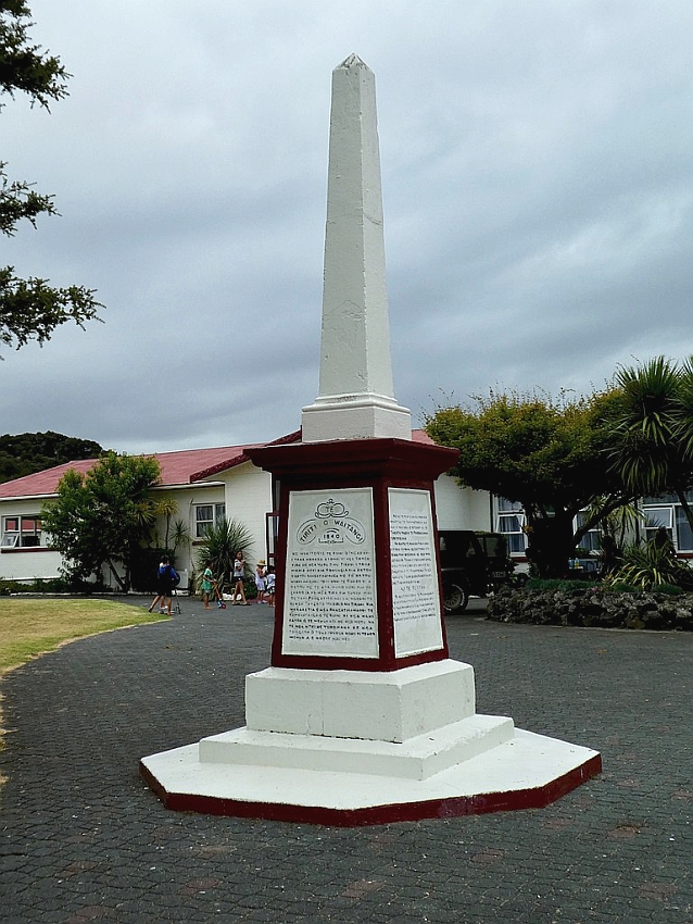
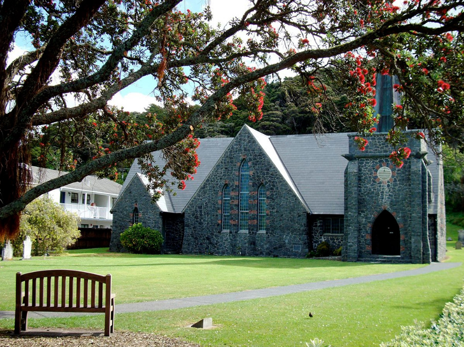

Sign up to hear more
Get the latest heritage news, features and events delivered
straight to your inbox.
