

The Ōwairaka (Mt Albert) landscape has links with many ancestral footprints. Ōwairaka maunga and its associated area are also known as Te Ahi kā a Rakataura (the long burning fires of Rakataura), Rakataura being the leading tohunga on the Tainui waka. A fortified pā on the maunga overlooks fertile volcanic soils, which were extensively cultivated. Lands in central Tāmaki were held by Te Waiohua in the seventeenth century, and later by Ngāti Whātua. Soon after Auckland was established in 1840 for a colonial capital, the area north of Ōwairaka was obtained by the British Crown. From 1849, over 600 acres were purchased by Allan Kerr Taylor (1832-1890) for a gentlemanly estate on the rural fringes of the city. As settlement in the Auckland area increased during the economic boom of the 1870s, Taylor offered part of his land for an Anglican church and graveyard, as well as contributing money for construction and helping to lead the establishment committee.
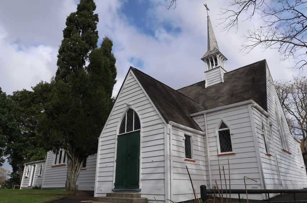
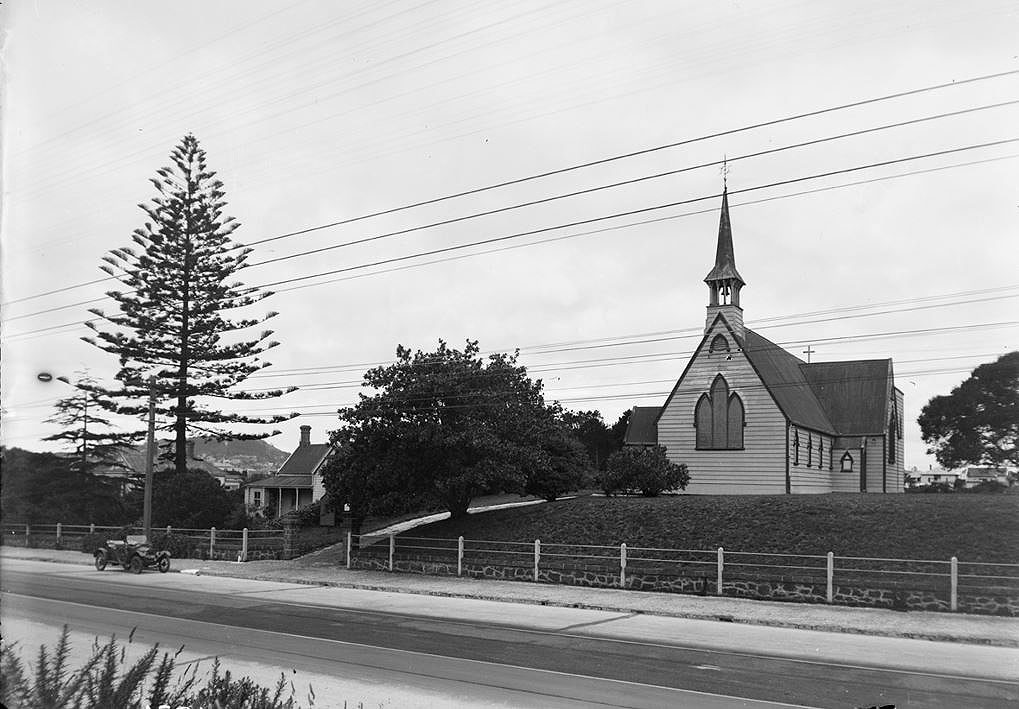
Located near the early gateway to Taylor’s large residence at Alberton, St Luke’s Church was prominently erected on a knoll beside New North Road. Its initial design by Pierre Finch Martineau Burrows (1842-1920) – who later became Chief Draughtsman in the Colonial Architect’s office – consisted of a nave and chancel, with spire, porch and vestry. Unusually for Anglican churches of the period, all seating was initially rent-free. Its incorporation of a graveyard, in use by 1874, reflects the rural nature of its original setting and traditional English models for a country church. A parsonage (later vicarage, since removed) was also built next to the church.
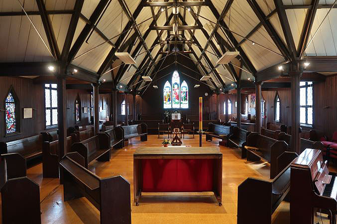
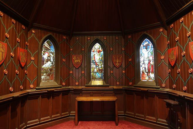
Local landowners subsequently subdivided their properties for middle-class villas as Mt Albert became absorbed into the Auckland conurbation. In 1882-3, Taylor provided part of the cost for church additions designed by the notable architect Edward Bartley. More than doubling its capacity, the expanded building now featured an elegant bell turret, apse and transepts as well as a fully lined interior. The remodelled design was used to advertise subdivisions for sale. In 1896, Bartley also oversaw construction of an immediately adjacent hall of complementary appearance, utilised as a Sunday School as well as for social, political and other meetings. Oak trees – symbolic of Englishness and religious steadfastness – and other plantings were established. Further extension of the church occurred in 1932. Ongoing burials included that of Allan Kerr Taylor and members of his family, who maintained a long tradition of support for the church. An area of the graveyard was set aside for interment of ashes in 1988, and the yard closed for burials.
Particularly since the 1980s, the congregation has promoted issues such as expansion of the roles of women and LGBTTFQI+ people in the church, environmental consciousness and of socially disadvantaged people. It has actively welcomed people of diverse backgrounds, including from the rainbow community. Reflecting inclusivity and more active involvement of congregation members in services, some internal church arrangements such as pew and altar positions have been modified. The place remains a distinctive green space indicative of its rural and early suburban origins. Other notable features include commemorative trees and now-rare Auckland examples of timber burial enclosures in the graveyard.
List Entry Information
Status
Listed
List Entry Status
Historic Place Category 2
Access
Private/No Public Access
List Number
681
Date Entered
7th April 1983
Date of Effect
7th April 1983
City/District Council
Auckland Council
Region
Auckland Council
Extent of List Entry
Extent includes the land described as Pt Allot 170 Suburbs of Auckland (RT NA561/289), Lot 1 DP 190718 (RT NA120C/419) and Pt Lot 79 DP 384 (RT NA81/195), North Auckland Land District, and the building and structures known as St Luke’s Church (Anglican) thereon.
Legal description
Pt Allot 170 Suburbs of Auckland (RT NA561/289), Lot 1 DP 190718 (RT NA120C/419) and Pt Lot 79 DP 384 (RT NA81/195), North Auckland Land District
Construction Professional
Name
J. H. Buchanan
Type
Stonemason
Biography
James Hogg Buchanan (1846-1937) James Hogg Buchanan (1846-1937) was born in Killbarchan, Renfrewshire, Scotland. He emigrated to Auckland with his stonemason father, Edward Buchanan and family in late 1861. He is said to have become a member of his uncles’ firm J. and G. Buchanan, stonemasons and monumental masons, which was later described as created in 1862 and ‘the first of its kind to be established in Auckland’. However, his father established a comparable business at a similar time, advertising his services in January 1863 as a builder and stonecutter with ‘a large number of Monuments, Tombs and Headstones of the newest designs’. J.H. Buchanan took over his father’s business in 1866, initially operating from Karangahape Road, near Symonds Street Cemetery - Auckland’s main burial ground. By 1871, James Buchanan was running the Auckland Stone Works on Victoria and Lorne Streets, and offering to forward designs ‘to the country and adjoining provinces’. Commissions included a head, body and footstone for John Tutin at St Michael’s Church, Hakaru, Mangawai. A brief partnership with William Thomas in 1875-7 functioned as J.H. Buchanan and Company, before this business became insolvent. Buchanan was briefly employed by John Brown of the Victoria Stone Works before purchasing the firm. In 1884, he oversaw the erection of a large and prestigious monument in Symonds Street Cemetery, dedicated to the Auckland businessman and philanthropist, Edward Costley. In the early and mid-1890s, Buchanan gained a further series of prestigious commissions, including monuments for King George of Tonga, requested by the Tongan government (1893-4); the Kīngitangi leader Pōtatau Te Wherowhero, commissioned by the New Zealand government (1895); and Auckland businessman and benefactor James Dilworth (1895). In 1898, Buchanan moved to new premises, the Monumental Works in Symonds Street. He died, aged 94, in 1937. At this time, he was referred to as the ‘Father of Stonemasons in New Zealand’, with many of Auckland’s monumental masons having gained their early experience in his employment.
Name
Basil Hooper
Type
Architect
Biography
No biography is currently available for this construction professional
Name
Grey and Malcolm
Type
Builder
Biography
No biography is currently available for this construction professional
Name
J.H Smith
Type
Builder
Biography
No biography is currently available for this construction professional
Name
Banks Bros
Type
Stonemason
Biography
No biography is currently available for this construction professional
Name
F. Harris
Type
Stonemason
Biography
No biography is currently available for this construction professional
Name
William Parkinson & Co.
Type
Stonemason
Biography
Sculptors and Monumental Masons based in Victoria Street, Auckland.
Name
Burrows, Pierre Finch Martineau
Type
Architect
Biography
Burrows was born in Norwich, England, and arrived in New Zealand about 1863. He began working under W H Clayton in the Colonial Architect's Office in 1874 and became Chief Draughtsman in 1875. When Clayton died, Burrows took over his duties, but he did not receive a designation of Colonial Architect. Burrow's most important buildings include the Post Office at Christchurch (1877), the Supreme Court House, Wellington (1879), and the Mount Eden Prison (begun 1883). He was also responsible for a number of smaller post offices and courthouses. His brother Arthur Washington Burrows was also an architect, practising in Auckland and Tauranga.
Name
Bouskill, John
Type
Stonemason
Biography
John Bouskill (c.1854-1933) was born in Westmorland, in northwest England. He emigrated with his family to New Zealand in 1883. After spending a year in Dunedin, Bouskill moved to Auckland where he initially worked as a building contractor with his brother William. In 1888, John Bouskill was responsible for the masonry of the Governor Browne Hotel in Hobson Street. The following year, he successfully tendered for the creation of a memorial tablet for the Auckland Free Library. By 1891, Bouskill was in partnership with Peter McNab. Advertising as monumental masons, the firm was based in premises close to Symonds Street cemetery. As well as making and selling funerary monuments, Bouskill and McNab undertook general masonry work. Memorial tablets of their making included one in St Patrick’s Cathedral to commemorate Bishop Luck (1896). In 1899, they were awarded a gold medal and three first awards at the Auckland Industrial and Mining Exhibition. The partnership was dissolved in 1902, after which Bouskill operated on his own account. As well as being a stonemason, Bouskill was a member of the Newton Borough Council; a chairman of the Mount Albert Road Board; and the second vice-president of the Auckland Bowling Centre. He died in 1933. Bouskill’s son, John Bouskill junior, also operated as monumental mason.
Name
Bouskill and McNab
Type
Stonemason
Biography
No biography is currently available for this construction professional
Name
Bartley, Edward
Type
Architect
Biography
Edward Bartley was born in Jersey in 1839, and educated in the Channel Islands where he learned techniques of the building trade from his father, an architect and builder. Bartley immigrated to New Zealand with his elder brother Robert, also an architect, while still in his teens. They eventually settled in Devonport, Auckland. Initially Edward was in the building trade but later he practised solely as an architect. He was at one time vice-president of the Auckland Institute of Architects and was also Diocesan Architect for the Church of England. Amongst Bartley's most notable works were his ecclesiastical buildings including St John's Church, Ponsonby (1881), St David's Church, Symonds Street (1880), Holy Trinity Church, Devonport, and the Synagogue (1884). He was also responsible for the Opera House (1884) and Auckland Savings Bank, Queen Street (1884).
Construction Details
Start Year
1872
Type
Original Construction
Description
Original construction of church building and creation of graveyard
Start Year
1874
Type
Other
Description
Earliest recorded burial in graveyard
Start Year
1879
Type
Additional building added to site
Description
Original construction of parsonage (later vicarage); removed 1999
Start Year
1882
Finish Year
1883
Type
Modification
Description
Church lined and reshingled
Start Year
1882
Finish Year
1883
Type
Addition
Description
Church transepts, apse, bell turret added
Start Year
1896
Type
Original Construction
Description
Church hall and Sunday School
Start Year
1908
Type
Modification
Description
Church re-roofed with iron
Start Year
1932
Type
Addition
Description
Church nave widened and extended
Start Year
1941
Finish Year
1942
Type
Modification
Description
Concrete repairs in graveyard
Start Year
1945
Type
Original Construction
Description
Robing room near south porch created from converted Army hut
Start Year
1948
Finish Year
1949
Type
Modification
Description
Church interior altered, including chancel floor extended; and hall roof reshingled
Start Year
1950
Type
Addition
Description
Church extended at west end, incorporating porch into the nave and a new porch entrance
Start Year
1959
Type
Original Construction
Description
Youth Hall erected
Start Year
1959
Type
Addition
Description
Church hall extended
Start Year
1965
Type
Restoration
Description
Replacement cross on bell turret
Start Year
1966
Finish Year
1968
Type
Addition
Description
Robing room extended and covered way added to connect it with the church
Start Year
1974
Type
Modification
Description
Church re-roofed
Start Year
1977
Type
Modification
Description
New doors to front entrance of church and repairs to bell turret
Start Year
1988
Type
Modification
Description
Cremation plots section created in graveyard
Start Year
2009
Type
Modification
Description
Sprinkler system added to church
Historical and Associated Iwi / Hapū / Whānau
Public NZAA Number
R11/3383
Completion Date
29th June 2022
Report Written By
Martin Jones
Information Sources
Daily Southern Cross
Daily Southern Cross
Bartley, 2006
M W Bartley, Colonial Architect, The Career of Edward Bartley 1839-1919, Wellington, 2006
New Zealand Herald
New Zealand Herald, ‘Historic Hut is Preserved’, 25 March 1961
Dunsford, 2016
Dunsford, Deborah, Mt Albert Then and Now: A History of Mt Albert, Morningside, Kingsland, St Lukes, Sandringham and Owairaka, Auckland, 2016.
New Zealand Society of Genealogists, 1968
New Zealand Society of Genealogists, ‘St Lukes Anglican Church Cemetery, New North Road, Mt Albert, Auckland’, n.p., 1968.
Paine, 1997
Paine, Selwyn M., At the Crossroads: A History of Saint Luke's Church, Mount Albert, Auckland, New Zealand for the years 1972-1997, Auckland, 1997.
Schubert, 1974
Schubert, Nora, Church of St Luke, 1872-1972, Auckland, 1974.
Other Information
This place was identified as significant under previous legislation with different information requirements. It remains significant under the current legislation. There is opportunity under our legislation and policies to add to this information. Further information about this place may be available from the Northern Regional Office of Heritage New Zealand Pouhere Taonga. Please note that entry on the New Zealand Heritage List/Rarangi Korero identifies only the heritage values of the property concerned, and should not be construed as advice on the state of the property, or as a comment of its soundness or safety, including in regard to earthquake risk, safety in the event of fire, or insanitary conditions.
Current Usages
Uses: Commemoration
Specific Usage: Memorial tree(s)/planting
Uses: Religion
Specific Usage: Church
Uses: Religion
Specific Usage: Churchyard
Former Usages
General Usage: Religion
Specific Usage: Vicarage/Manse/Presbytery/Rectory
Themes
Rainbow List
Current Usages
Uses: Commemoration
Specific Usage: Memorial tree(s)/planting
Uses: Religion
Specific Usage: Church
Uses: Religion
Specific Usage: Churchyard
Former Usages
General Usage: Religion
Specific Usage: Vicarage/Manse/Presbytery/Rectory
Themes
Rainbow List
Location
Sign up to hear more
Get the latest heritage news, features and events delivered
straight to your inbox.
