

Prior to the arrival of Colonial settlement in Wellington, Mount Cook was the site of the Rangitane pa, Pukeahu. Following the arrival of the New Zealand Company in 1839, whose policy it was to reserve every tenth section of Wellington for Maori, the land around Mount Cook was reserved for Te Aro iwi. In 1850 13 acres of land was granted to the Ordnance Department of a Government Reserve for the mounting guns and military storage, by Lieutenant Governor Eyre of New Munster province. The Crown bought Sections 89 and 90 on 24 March 1874, purchasing the land from Maori for £500. By 1882 Defence Department buildings (artillery barracks) were erected on Section 90.
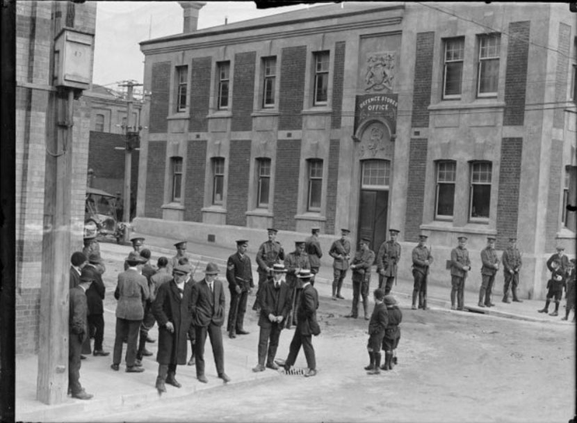
The strategic location of Mount Cook was important to early Wellingtonians as they were wary of a Maori attack and wanted a defensive position over the town. In 1871 a grand gaol, replacing an old wooden prison, was planned but only partially completed on the summit of Mount Cook. The building instead served other purposes and the front part of the 'gaol' was used by the General Officer Commanding as a headquarters from 1903. In 1911, artillery barracks on the corner of Taranaki and Buckle Streets were demolished to make way for what is now known as the General Headquarters Building (Former). It was designed to house the Director of Stores' offices and was probably also used as a clothing store.
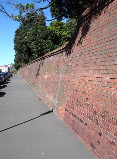
Designed in the Government Architect John Campbell's offices in the Edwardian Baroque style, the building is an important representative example of early twentieth century architecture. The authenticity of the street facades (apart from decoration that has been lost at roof level following the 1942 earthquake) is high. The building complemented the architectural style adopted for all buildings constructed on Buckle Street in the late nineteenth and first decade of the twentieth century. These aimed at commonality of style, sharing features such as the use of bricks as a building material, the majority of which are likely to have been made by convicts from the Mount Cook gaol.
In the mid 1920s the site of Mount Cook was chosen for the Dominion Museum, Art Gallery and War Memorial. As the old gaol was to be demolished the Army headquarters had to be relocated. By 1929 the Defence stores had moved to Fort Dorset, and the Director of Stores' office building, which was used to store base records from 1923, was taken over by the Defence Headquarters. When the army renovated the building for their relocation they used materials from the old gaol to create partitions. This reuse of materials adds to the time depth of the General Headquarters Building (Former). Defence Headquarters remained in the building until 1938 when it moved temporarily to Featherston Street until the new Departmental Building was completed on Stout Street in [1940]. The General Headquarters Building (Former) remained in the army's ownership until 1962, when ownership was transferred to the Ministry of Works (MOW) but was leased to various organisations including the Health Department Education Branch from 1948-1979. From 1979 the building was leased to the Department of Internal Affairs and was used for storage and as a Conservation Laboratory by the Museum into the mid-1980s. The building was returned to the New Zealand Defence Force in 2002.
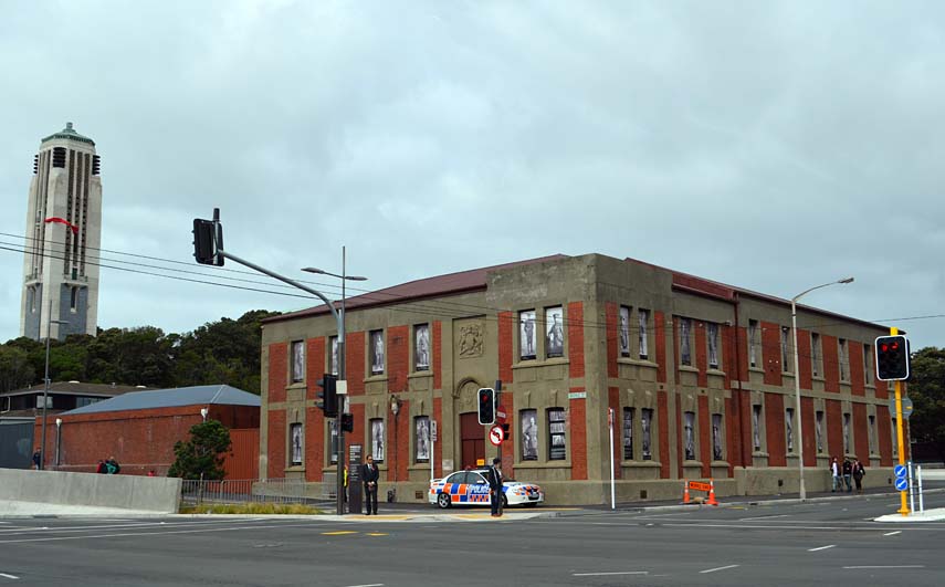
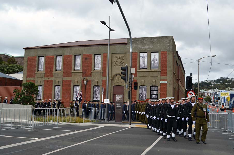
Today the building forms a landmark on the corner of a busy intersection. Together with the historic Mount Cook Police Station (1894), the buildings form a pair of buildings anchoring the military history of the area into the modern urban landscape.
List Entry Information
Status
Listed
List Entry Status
Historic Place Category 2
Access
Private/No Public Access
List Number
7518
Date Entered
13th June 2003
Date of Effect
13th June 2003
City/District Council
Wellington City
Region
Wellington Region
Extent of List Entry
Extent includes the land described as Section 90 Town of Wellington, Wellington Land District and the building known as the General Headquarters Building (Former) and its fittings and fixtures.
Legal description
Sec 90 Town of Wellington, (Crown Land Set Apart for Defence Purposes in the City of Wellington, NZ Gazette 1985, p.4089), Wellington Land District
Why is this place significant?
Historic Significance
Historical Significance or Value This historic place was registered under the Historic Places Act 1993. The following text is from the original Historic Place Registration Proposal report 2003 considered by the NZHPT Board at the time of registration. Historical Significance: It is the oldest general administrative military building left in Wellington and, from 1929 to 1938, it was the temporary home of the General Officer Commanding for the Army. Although the present headquarters soon superseded it, this period of use elevates the status of the building. In addition, the long military association with the land and the circumstances of its acquisition imbues it with further historic interest. The Departmental building on Stout Street which took over the role as the army headquarters in 1945 continues with this role today. It is registered as Category II. This building is the only building on the Register that was, and still is, directly associated with military planning and organisation at the national level. However, the GOC Building in Buckle Street predates the Departmental Building by 29 years. Therefore, the GOC building is the only example of a place directly associated with these organisational and administrative functions of the army on a national level which predates the second world war. Although no major decisions were taken in this building its place in the military history of Wellington is important.
Physical Significance
This historic place was registered under the Historic Places Act 1993. The following text is from the original Historic Place Registration Proposal report 2003 considered by the NZHPT Board at the time of registration. Archaeology: Wooden barracks were built for the NZ Permanent Artillery c.1882 which were pulled down to build the present building in 1911. There is potential for archaeological features of these buildings and artefacts from army use of the barracks to remain under the present GOC building and its surrounding area. Therefore, in the absence of early British Army wooden barracks the brick replacement building, 1911, with its Coat of Arms above the door, is the sole remaining structure which has the age and presence to link an extensive history of the location. Architectural: Although 'utilitarian' in design it is important as a representative example of early 20th century architecture in the Edwardian Baroque style, of which few remain in Wellington. The authenticity of the street facades (apart from decoration that has been lost at roof level) is high. Its significance is how it complemented the architectural style adopted for all buildings constructed on Buckle Street in the late 19th and first decade of the 20th Century aimed at commonality of style including the use of bricks made. Also it was designed to create a balance with the truncated tower constructed in 1907/08 as a part of the Drill Hall (former) on the northern side of Buckle Street and corner of Taranaki Street.
Why is this place Category 1 / Category 2?
Detail Of Assessed Criteria
This historic place was registered under the Historic Places Act 1993. The following text is from the original Historic Place Registration Proposal report 2003 considered by the NZHPT Board at the time of registration. (a) The extent to which the place reflects important or representative aspects of New Zealand history: The building is representative of a particular aspect of military history not often recorded. Its functions were administrative which places it in different class of military building from a store, a barrack or a drill hall. The site was used for barracks from 1882 when the NZ Artillery was formed. An important aspect in military history. (b) The association of the place with events, persons, or ideas of importance in New Zealand history: Events: 1913 strike. The GOC building is one of a few permanent reminders of this event. The building housed special constables enlisted to reinforce the regular police. Also the building may have been used as an assembly point for the Samoan Expeditionary Force. But more important decisions relating to this campaign were taken elsewhere. People: John Campbell became Government architect in 1909 and was in charge of the architectural design of government buildings in New Zealand (including the GOC building) until his retirement in 1922. Campbell successfully established Edwardian Baroque as the official architectural style for government buildings in New Zealand in the early twentieth century. This style established for government buildings by Campbell, was not adopted by his successor therefore any remaining buildings in New Zealand are unique to his period of work. Although many have now been demolished, probably more examples of his work are known to New Zealanders, although anonymously, than buildings designed by any other architect. Ideas: The site of this building has a long government and defence history (both Maori and European) and is part of the wider area of Mount Cook which had a military presence from c.1850. That longevity of association and continuity of use is remarkable by New Zealand standards. Other ideas are shown in the technological skills used to make modifications to earthquake prone buildings. (c) The potential of the place to provide knowledge of New Zealand history: The site has historical value as there were buildings built prior to 1900 whose subsurface remains have potential to provide information on the early use of the area. (f) The potential of the place for public education: By looking at the GOC building and the surrounding Mount Cook area a visitor could picture the historic military landscape. Also the presence at the other end of Buckle Street of the Mount Cook Police Station by complementing each other reinforce the military use of the landscape to the general public. (g) The technical accomplishment or value, or design of the place: Although not the best example of the Baroque style it was designed to fulfil a utilitarian purpose and when regarded in its urban context it complements the contemporary former police building on the comer of Buckle and Tory Street. It is its association with a long period of military history and its uniformity in architecture with other (mostly now demolished) buildings on Buckle Street, which make it significant. (h) The symbolic or commemorative value of the place: A continuous military presence on the building's site, c.120 years, is unique in the history of New Zealand and therefore solicits acknowledgement in terms of historic merit. (j) The importance of identifying rare types of historic places: This building is important as it is the oldest building in New Zealand which housed the army headquarters. It predates the present building on Stout Street which took over the role in 1940 which is registered at Category 2. (k) The extent to which the place forms part of a wider historical and cultural complex or historical and cultural landscape: The building has some townscape value, anchoring the historically important block of land known as Mount Cook in a similar way to that of the former Mount Cook Police Station at the other end of Buckle Street. The surrounding landscape of the GOC building (the Mount Cook area) has a long government and defence history (both Maori and European). The recognition by Maori that this was a good defence location (site of Rangitane pa) was also identified by Lieutenant George Bennett in 1844 who hoped to build a barracks. There has been a military presence on Mount Cook since c.1850. That longevity of the military association and continuity of use of the Mount Cook area is remarkable by New Zealand standards.
Construction Professional
Name
Campbell, John
Type
Architect
Biography
John Campbell (1857-1942) served his articles under John Gordon (c1835-1912) in Glasgow. He arrived in Dunedin in 1882 and after a brief period as a draughtsman with Mason and Wales joined the Dunedin branch of the Public Works Department in 1883. His first known work, an unbuilt design for the Dunedin Railway Station, reveals an early interest in Baroque architecture. In November 1888 Campbell was transferred to Wellington where in 1889 he took up the position of draughtsman in charge of the Public Buildings Division of the Public Works Department. He remained in charge of the design of government buildings throughout New Zealand until his retirement in 1922, becoming in 1909 the first person to hold the position of Government Architect. Government architecture designed under his aegis evidences a change in style from Queen Anne to Edwardian Baroque. His best-known Queen Anne design is the Dunedin Police Station (1895-8), modelled on Richard Norman Shaw's New Scotland Yard (1887-90). Among his most exuberant Edwardian Baroque buildings is the Public Trust Office, Wellington (1905-09). Although Campbell designed the Dunedin Law Courts (1899-1902) in the Gothic style with a Scottish Baronial inflection, he established Edwardian Baroque as the government style for police stations, courthouses and post offices throughout New Zealand. In 1911 Campbell won the nation-wide architectural competition for the design of Parliament Buildings, Wellington. Although only partially completed, Parliament House is the crowning achievement of Campbell's career.
Construction Details
Start Year
1911
Finish Year
1912
Type
Original Construction
Start Year
1912
Type
Other
Description
Date formally opened: Reported in September 1912 AJHR Defence report.
Start Year
1929
Type
Modification
Description
Alterations to accommodate General Headquarters' staff. Many interior fittings such as partitions were reused from the Alexander Barracks.
Start Year
1941
Type
Modification
Description
Internal alterations recorded until 1941 to facilitate the full potential of the building as a headquarters. Entrance way altered.
Start Year
1942
Type
Modification
Description
Earthquake repairs. Remove brick arch and plaster the adjoining walls.
Start Year
1943
Type
Modification
Description
Earthquake repairs. Demolish chimneys with top-hamper and replace with ones without. Demolish internal gable to the ceiling. Demolish all masonry above the first floor window head and replace with concrete bands.
Construction Materials
Brick - possibly made by convicts who made bricks at Mount Cook brickyards until 1920s.
Notable Features
GOC building Entrance way to the building Coat of arms above entrance
This historic place was registered under the Historic Places Act 1993. The following text is from the original Historic Place Registration Proposal report 2003 considered by the NZHPT Board at the time of registration. Information in square brackets indicates modifications made after the paper was considered by the NZHPT Board. History of the place: Prior to the arrival of European settlement, the Rangitane pa, Pukeahu, occupied the site of Mount Cook. Following the arrival of the New Zealand Company, 1939, the land around Mount Cook was reserved for Te Aro iwi as part of the Wellington Tenths. The New Zealand Land Company, which was established in 1839, released a prospectus of lands for sale in town and country sections which included references to land which would be distributed to chief families of the iwi from which the land was originally purchased. The integration of Maori reserves into Wakefield's colonisation theory were designed to promote amalgamation with the settlers. They were called Wellington Tenths as every tenth section in the proposed town plan was to be allocated to Maori. The official military significance of Mount Cook began in February-March 1844, when Lieutenant George Bennett, Commanding Officer of the Royal Engineers, was in Wellington. He wrote to the Colonial Secretary requesting that a Crown Grant be made to the Ordnance Board of Maori Reserve land in Wellington for the purpose of building a barracks. It appears to be the case that Bennett wanted the top of Mount Cook, but since there was already a prison there (probably later destroyed in 1848 earthquake) the Colonial Secretary suggested alternative sections in Thorndon. The strategic location of Mount Cook was important to early Wellingtonians as they were wary of a Maori attack and wanted a defensive position over the town. The Ordnance Department was granted a Crown Grant on 9th May 1850 for 5.26 hectares of the domain on Mount Cook for the Military; at this point it did not include Section 90 the area where the [GHQ] building was later built. There is sufficient evidence here to support the claim of the Army Association that the Mount Cook area has had a military presence since the early days of the Wellington settlement. This presence goes back at least 150 years. Records show that a military barracks was built on top of Mount Cook for the Royal Engineers c.1850. This barracks remained until c.1877, during which time it billeted the 65th regiment. A new barracks was built on the corner of Taranaki and Buckle Street c.1882. This area of land was not in the original area gazetted for defence purposes in 1850 nor was it incorporated in an 1867 plan which shows Section 90 as still part of a Native Reserve and not incorporated into the 5.26 hectares granted to Defence. However, the Crown bought sections 89 and 90 on 24th March 1874, purchasing the land from Maori for £500. There is no title available but Land Information New Zealand issued a Gazette for Section 90 in 1985. The wooden barracks constructed by the British Garrison were on the site from c.1882 to 1911. The building date has been inferred from changes to the Army's structure. Until 1910, this comprised a Volunteer Militia set up under the Militia Act of 1858, and consisting of Infantry, Cavalry and Artillery. Of this group, the Artillery were placed on a regular footing in 1882, coinciding with the outbreak of the Russian Scare, and acting on Colonel Scratchley's report on coastal defences of 1880. The 1882 date would appear to confirm the building of the 'Permanent Artillery barrack' on the corner of Buckle and Taranaki Streets. Also that year [is when] it first appears on an official map. The Permanent Artillery was housed at this site until the outbreak of the South African (Boer) War in 1899. From 1891-1899 the outstanding master gunner George Spafford Richardson (later General Sir George Richardson) was located in the barracks. He commanded the New Zealand forces in England in World War One, who became famous for defending Antwerp with a handful of men from the Royal Navy Division. The wooden barracks were demolished and replaced by The Defence Stores Office building in 1911/1912. The soldiers were moved to new brick barracks on Mount Cook. The whole Mount Cook area was intimately related by the use of brick. Bricks were made by prisoners at the gaol until 1920. These bricks were marked with a prison arrow which can be seen in the walls of the Mount Cook Police [Station]. Although none could be seen on the inside and outside of the [GHQ] building it has been suggested that the part of the brick stamped with an arrow would have been on the top surface, built into the wall, rather than the visible sides of the brick. The [GHQ] building was [designed] as a reflection of the other buildings on the street and built in sympathy with their utilitarian style. These contemporary buildings used for military administration [in the] Mount Cook complex and Buckle Street have since been destroyed, leaving [the GHQ Building] the oldest existing military administration building in Wellington. It is the oldest [GHQ] headquarters as it predates the present building in Stout Street. The building represents over 120 years of military history on [the] site. A report in the Appendices to the Journals to the House of Representatives dated September 1912 records that a clothing store in brick had been built and that an office for the Director of Stores and his Clerical Staff was being erected 'to replace the old and unsanitary premises previously occupied, and which were originally erected by the imperial troops some sixty years ago.' This suggests that the offices were built on the old artillery barracks. However, this building was erected in 1912, whereas the plaque on the [GHQ] building states 1911. However, the building could have fulfilled both these purposes - as a store and as offices. It could have been built in two stages and in 1911 a plaque was placed to commemorate the first [Buckle Street] part of the building. A clothing store was needed to 'ensure the safety, and to facilitate the handling, of the large supply of clothing and miscellaneous stores required for the equipment of the Territorial Force and Senior Cadets.' The presence of a winch on the Buckle Street side of the building suggests possible use of the upper floor for stores. The Military Stores Department was created in 1855 and [was] present on Mount Cook from 1856. In 1929 the Defence Stores moved to Fort Dorset leaving their building vacant. A fire in Wellington Archives 1955/56 destroyed many of the files related to this building, leaving gaps in the information available. Designed [by] the Government Architect John Campbell's offices in the Edwardian Baroque style with the segmentally arched hood moulding over the main door on Buckle Street, with the legend 'GR V 1911' below it, [the building] is a reminder of this Baroque preference which became very much identified with the British Imperial Tradition. There is also a Royal Coat of Arms directly above this arch. The building is important as a representative example of early 20th century architecture in the Edwardian Baroque style that was Campbell's speciality. The authenticity of the street facades (apart from decoration that may have been lost at roof level) is high. The building complemented the architectural style adopted for all buildings constructed on Buckle Street in the late 19th and first decade of the 20th century, aimed at commonality of style including the use of bricks likely to have been made by prisoners from the Mount cook gaol. It also was strong enough to withstand a series of earthquakes, particularly the one in 1942. After the 1942 earthquake the building was shorn of much of its external decoration and, in more recent years, it has provided a place to hang large billboards for Taranaki Street traffic. The [GHQ] building is one of a few, permanent remainders of the 1913 Maritime Strike, which began as a dispute of trivial origin (a complaint by Shipwrights about travelling time) that escalated into a determined battle between the Employers Federation and the Union of Federated Labour (UFL). A stop work meeting was held at 8am on October 22nd 1913 by the waterside workers union and by 10am their jobs had been filled by Union men. Riots broke out between the strikers, 'Red Feds' who only had stones as weapons and The Specials who were on horseback with batons. On November 3rd a serious riot broke out near Buckle Street. The building housed Special Constables, mostly farmer's sons, enlisted to reinforce the regular police. A meeting was held at Garrison Hall, Buckle Street, to form a new waterside worker's register which was signed under the protection of 'Specials'. On December 8th the new union, 2000 strong, invited the old union to join of which 300 responded, which confirmed to the strike leaders that they had lost. The strike was called off on December 20th 1913. However, there was a longstanding bitterness over the strike by the workers. The Defence Headquarters had previously occupied the unpopular huge brick building on [the] top of Mount Cook, originally begun as one wing of a prison in 1882 and not designed to house offices effectively. It occupied the old gaol from 1903 until forced to leave in 1929, as the building was demolished (1931) to make way for the construction of the Dominion Museum and War Memorial on the site, opened 1936. As a result, the headquarters were relocated to the former Defence Stores building. The General Officer Commanding the Army (otherwise known as Defence Headquarters) was the occupant from 1929. The store building had to be reconditioned for the Defence Headquarters at the estimated cost of £884. Timber was reused from the old Head Quarters on Mount Cook and in hindsight it would have been cheaper to purchase new timber. However, the reuse of partitions from the old HQ building adds significance to the [GHQ] building's use. The actual costs for alterations were considerably higher at £1461.11.3. This meant from 1889 through to 1929 the military regained its old position on top of the hill in addition to its new position at the bottom of the hill, then, when the building of the former National Art Gallery and Museum began, the military once again had to retire to the bottom of the hill. The Defence Headquarters moved from its Buckle Street premises to the ground floor of Featherston Street on 20th April 1938. They later moved in 1945 to the newly built Departmental Building, Stout Street. The Defence Headquarters are still located in the Stout Street in 2003. The [GHQ] building was described as 'unsuitable and inadequate' by Lieutenant Colonel Quartermaster General to the Sea on November the Ninth 1934. It underwent a series of alterations during the GOC Headquarters' residence in the building. Since the [GHQ] use of the building there have been a variety of occupiers. After the Government Accommodation Board [used] the building as offices in 1947 it was leased for a long period to the Health Department Education Branch. They used the building from 1948-1979 and it has been suggested that the upper floor of the building was used as a dentistry clinic. In 1962 the ownership of the building was transferred to the Ministry of Works (MOW) at the book value £4954. After the Health Board the building was leased by the Department of Internal Affairs, who used the building for Museum use (storage) under MOW department conditions (which limited numbers in the building) initially on a four year term. From 1983 the Internal Affairs occupancy continued on a monthly basis. It is not clear when Internal Affairs finally vacated the building. In 2002 Land Information New Zealand transferred the building back to the ownership of the Defence Force who owned the land. Today the building is empty except [for] occasional use by Naval Cadets. In 2003, the building is undergoing a city council review of possible earthquake prone buildings to assess its future. The [GHQ] building forms a landmark on the corner of a busy intersection. Together with the Buckle Street Police Station, the buildings form a pair of contemporary early 20th century buildings anchoring the military history of the landscape into the modern urban environment.
This historic place was registered under the Historic Places Act 1993. The following text is from the original Historic Place Registration Proposal report 2003 considered by the NZHPT Board at the time of registration. Information in square brackets indicates modifications made after the paper was considered by the NZHPT Board. History of the place: Prior to the arrival of European settlement, the Rangitane pa, Pukeahu, occupied the site of Mount Cook. Following the arrival of the New Zealand Company, 1939, the land around Mount Cook was reserved for Te Aro iwi as part of the Wellington Tenths. The New Zealand Land Company, which was established in 1839, released a prospectus of lands for sale in town and country sections which included references to land which would be distributed to chief families of the iwi from which the land was originally purchased. The integration of Maori reserves into Wakefield's colonisation theory were designed to promote amalgamation with the settlers. They were called Wellington Tenths as every tenth section in the proposed town plan was to be allocated to Maori. The official military significance of Mount Cook began in February-March 1844, when Lieutenant George Bennett, Commanding Officer of the Royal Engineers, was in Wellington. He wrote to the Colonial Secretary requesting that a Crown Grant be made to the Ordnance Board of Maori Reserve land in Wellington for the purpose of building a barracks. It appears to be the case that Bennett wanted the top of Mount Cook, but since there was already a prison there (probably later destroyed in 1848 earthquake) the Colonial Secretary suggested alternative sections in Thorndon. The strategic location of Mount Cook was important to early Wellingtonians as they were wary of a Maori attack and wanted a defensive position over the town. The Ordnance Department was granted a Crown Grant on 9th May 1850 for 5.26 hectares of the domain on Mount Cook for the Military; at this point it did not include Section 90 the area where the [GHQ] building was later built. There is sufficient evidence here to support the claim of the Army Association that the Mount Cook area has had a military presence since the early days of the Wellington settlement. This presence goes back at least 150 years. Records show that a military barracks was built on top of Mount Cook for the Royal Engineers c.1850. This barracks remained until c.1877, during which time it billeted the 65th regiment. A new barracks was built on the corner of Taranaki and Buckle Street c.1882. This area of land was not in the original area gazetted for defence purposes in 1850 nor was it incorporated in an 1867 plan which shows Section 90 as still part of a Native Reserve and not incorporated into the 5.26 hectares granted to Defence. However, the Crown bought sections 89 and 90 on 24th March 1874, purchasing the land from Maori for £500. There is no title available but Land Information New Zealand issued a Gazette for Section 90 in 1985. The wooden barracks constructed by the British Garrison were on the site from c.1882 to 1911. The building date has been inferred from changes to the Army's structure. Until 1910, this comprised a Volunteer Militia set up under the Militia Act of 1858, and consisting of Infantry, Cavalry and Artillery. Of this group, the Artillery were placed on a regular footing in 1882, coinciding with the outbreak of the Russian Scare, and acting on Colonel Scratchley's report on coastal defences of 1880. The 1882 date would appear to confirm the building of the 'Permanent Artillery barrack' on the corner of Buckle and Taranaki Streets. Also that year [is when] it first appears on an official map. The Permanent Artillery was housed at this site until the outbreak of the South African (Boer) War in 1899. From 1891-1899 the outstanding master gunner George Spafford Richardson (later General Sir George Richardson) was located in the barracks. He commanded the New Zealand forces in England in World War One, who became famous for defending Antwerp with a handful of men from the Royal Navy Division. The wooden barracks were demolished and replaced by The Defence Stores Office building in 1911/1912. The soldiers were moved to new brick barracks on Mount Cook. The whole Mount Cook area was intimately related by the use of brick. Bricks were made by prisoners at the gaol until 1920. These bricks were marked with a prison arrow which can be seen in the walls of the Mount Cook Police [Station]. Although none could be seen on the inside and outside of the [GHQ] building it has been suggested that the part of the brick stamped with an arrow would have been on the top surface, built into the wall, rather than the visible sides of the brick. The [GHQ] building was [designed] as a reflection of the other buildings on the street and built in sympathy with their utilitarian style. These contemporary buildings used for military administration [in the] Mount Cook complex and Buckle Street have since been destroyed, leaving [the GHQ Building] the oldest existing military administration building in Wellington. It is the oldest [GHQ] headquarters as it predates the present building in Stout Street. The building represents over 120 years of military history on [the] site. A report in the Appendices to the Journals to the House of Representatives dated September 1912 records that a clothing store in brick had been built and that an office for the Director of Stores and his Clerical Staff was being erected 'to replace the old and unsanitary premises previously occupied, and which were originally erected by the imperial troops some sixty years ago.' This suggests that the offices were built on the old artillery barracks. However, this building was erected in 1912, whereas the plaque on the [GHQ] building states 1911. However, the building could have fulfilled both these purposes - as a store and as offices. It could have been built in two stages and in 1911 a plaque was placed to commemorate the first [Buckle Street] part of the building. A clothing store was needed to 'ensure the safety, and to facilitate the handling, of the large supply of clothing and miscellaneous stores required for the equipment of the Territorial Force and Senior Cadets.' The presence of a winch on the Buckle Street side of the building suggests possible use of the upper floor for stores. The Military Stores Department was created in 1855 and [was] present on Mount Cook from 1856. In 1929 the Defence Stores moved to Fort Dorset leaving their building vacant. A fire in Wellington Archives 1955/56 destroyed many of the files related to this building, leaving gaps in the information available. Designed [by] the Government Architect John Campbell's offices in the Edwardian Baroque style with the segmentally arched hood moulding over the main door on Buckle Street, with the legend 'GR V 1911' below it, [the building] is a reminder of this Baroque preference which became very much identified with the British Imperial Tradition. There is also a Royal Coat of Arms directly above this arch. The building is important as a representative example of early 20th century architecture in the Edwardian Baroque style that was Campbell's speciality. The authenticity of the street facades (apart from decoration that may have been lost at roof level) is high. The building complemented the architectural style adopted for all buildings constructed on Buckle Street in the late 19th and first decade of the 20th century, aimed at commonality of style including the use of bricks likely to have been made by prisoners from the Mount cook gaol. It also was strong enough to withstand a series of earthquakes, particularly the one in 1942. After the 1942 earthquake the building was shorn of much of its external decoration and, in more recent years, it has provided a place to hang large billboards for Taranaki Street traffic. The [GHQ] building is one of a few, permanent remainders of the 1913 Maritime Strike, which began as a dispute of trivial origin (a complaint by Shipwrights about travelling time) that escalated into a determined battle between the Employers Federation and the Union of Federated Labour (UFL). A stop work meeting was held at 8am on October 22nd 1913 by the waterside workers union and by 10am their jobs had been filled by Union men. Riots broke out between the strikers, 'Red Feds' who only had stones as weapons and The Specials who were on horseback with batons. On November 3rd a serious riot broke out near Buckle Street. The building housed Special Constables, mostly farmer's sons, enlisted to reinforce the regular police. A meeting was held at Garrison Hall, Buckle Street, to form a new waterside worker's register which was signed under the protection of 'Specials'. On December 8th the new union, 2000 strong, invited the old union to join of which 300 responded, which confirmed to the strike leaders that they had lost. The strike was called off on December 20th 1913. However, there was a longstanding bitterness over the strike by the workers. The Defence Headquarters had previously occupied the unpopular huge brick building on [the] top of Mount Cook, originally begun as one wing of a prison in 1882 and not designed to house offices effectively. It occupied the old gaol from 1903 until forced to leave in 1929, as the building was demolished (1931) to make way for the construction of the Dominion Museum and War Memorial on the site, opened 1936. As a result, the headquarters were relocated to the former Defence Stores building. The General Officer Commanding the Army (otherwise known as Defence Headquarters) was the occupant from 1929. The store building had to be reconditioned for the Defence Headquarters at the estimated cost of £884. Timber was reused from the old Head Quarters on Mount Cook and in hindsight it would have been cheaper to purchase new timber. However, the reuse of partitions from the old HQ building adds significance to the [GHQ] building's use. The actual costs for alterations were considerably higher at £1461.11.3. This meant from 1889 through to 1929 the military regained its old position on top of the hill in addition to its new position at the bottom of the hill, then, when the building of the former National Art Gallery and Museum began, the military once again had to retire to the bottom of the hill. The Defence Headquarters moved from its Buckle Street premises to the ground floor of Featherston Street on 20th April 1938. They later moved in 1945 to the newly built Departmental Building, Stout Street. The Defence Headquarters are still located in the Stout Street in 2003. The [GHQ] building was described as 'unsuitable and inadequate' by Lieutenant Colonel Quartermaster General to the Sea on November the Ninth 1934. It underwent a series of alterations during the GOC Headquarters' residence in the building. Since the [GHQ] use of the building there have been a variety of occupiers. After the Government Accommodation Board [used] the building as offices in 1947 it was leased for a long period to the Health Department Education Branch. They used the building from 1948-1979 and it has been suggested that the upper floor of the building was used as a dentistry clinic. In 1962 the ownership of the building was transferred to the Ministry of Works (MOW) at the book value £4954. After the Health Board the building was leased by the Department of Internal Affairs, who used the building for Museum use (storage) under MOW department conditions (which limited numbers in the building) initially on a four year term. From 1983 the Internal Affairs occupancy continued on a monthly basis. It is not clear when Internal Affairs finally vacated the building. In 2002 Land Information New Zealand transferred the building back to the ownership of the Defence Force who owned the land. Today the building is empty except [for] occasional use by Naval Cadets. In 2003, the building is undergoing a city council review of possible earthquake prone buildings to assess its future. The [GHQ] building forms a landmark on the corner of a busy intersection. Together with the Buckle Street Police Station, the buildings form a pair of contemporary early 20th century buildings anchoring the military history of the landscape into the modern urban environment.
This historic place was registered under the Historic Places Act 1993. The following text is from the original Historic Place Registration Proposal report 2003 considered by the NZHPT Board at the time of registration. Information in square brackets indicates modifications made after the paper was considered by the NZHPT Board. Occupants & Dates: 1911/1912-1929 - Defence Stores Office c.1929-1938 - Army HQ 1939-1946 - Discussions of the building's future after earthquake damage 1947 - Office for Government Office Accommodation Board 1948-1979 - Health Department Education Branch 1947-50 - Upper floor dentistry clinic for Technical College 1962 - Building transferred to MOW at book value (£4954) 1979 - Department of Internal Affairs occupy the building for Museum use (storage) under MWD conditions. (4 year term) 1983 - Internal Affairs occupancy continues on a monthly basis. It is not clear when Internal Affairs vacated the building. 2002 - Land Information New Zealand transfers the building back to Defence 2003 - New Zealand Defence Force Building unoccupied while earthquake risk assessed. Current Use: Empty building on Defence land. Occasionally used by Naval Cadets. Physical Description: The [GHQ] building stands on the comer of Taranaki and Buckle Streets, a plain and solid structure that reflects its army origins. The technical accomplishment is shown in the design of the building which is Free Style "Blood and Bandages" of the period c.1895-1915 and preferred for public buildings by Campbell. Features of "Blood and Bandages" style which can be read in the exterior of the [GHQ] Building are contrasting colours and textures, e.g. brick and plaster where plaster is used for detailing quoins, architraves, sills, parapets and string courses, with plain red brick for the walls. Other features of the style are the frequent use of a number of window types of different shapes and sizes. In the case of this building, segmentally-arched windows with keystones are used on the ground floor, while square-headed windows, double hung with glazing bars in the upper sash only, are used on the first floor. These red bricks laid in English bond (alternate courses of headers and stretchers), form the main structure material of the building, while plastered bands may indicate that there are concrete tie beams within the walls. The plan is L-shaped, the height is two storeys, and the main entrance is centred on the Buckle Street elevation. Decoration is subtle; it consists of panels of very shallow relief plaster work, with keystones emphasising the window heads. Windows are all timber and double hung, while over the door, an emblematic GRV 1911 is the only flourish in an otherwise very simple design. The stripped appearance of the building may be partly a result of the removal or loss of decorative work at roof level after 1942 earthquake. When examined in the context of the surrounding buildings the L-shaped plan creates an enclosed compound with the earlier stores buildings and a narrow entrance with a cast iron gate on the south side of the Buckle Street part of the building. The building could have been built to create a defensive compound. A commemorative plaque in the corner of the parade ground is in honour of the first stone of a building on the site in 1907. Possibly the other 'L' shaped building at the other side of the compound which has since been demolished. The [GHQ] building and part of the garage are all that remains of this early compound. The idea that the military needed an area which they could defend has continued from the original barracks on Mount Cook which had defensive walls in case of Maori attack. By moving the Headquarters to Stout Street in 1945 and having offices in a building shared with other governmental ministries represented the end of this style of defensive structures. The character of this building and its inclusion in a defensive area had an important role in the 1913 strike not only did it provide safe housing for the "Specials" it kept the strikers out. The roof is sheathed in corrugated iron (now rusty) and its form may indicate two stages 'of construction. This supports the AJHR report description of a clothing store and stores offices being built, suggesting two phases of building. The wing on Taranaki Street has a gabled roof, and it makes an awkward junction with the wing on Buckle Street which had a hipped roof. In addition, there is a change to plinth and window sill lines that indicate a staged construction, although architectural details between the two parts still match. It was designed to create a balance with the truncated tower constructed in 1907/08 as a part of the Drill Hall (former) on the northern side of Buckle Street and corner of Taranaki Street. Also it complemented the architectural style adopted for all buildings constructed on Buckle Street in the late 19th and first decade of the 20th Century which aimed at commonality of style including the use of bricks made [by prisoners from the Mount Cook gaol.] Remaining evidence of the original use of the building as a storage facility is shown in a winch and large doorway on the upper floor of the Buckle Street building located over the driveway. The room behind this is large with high ceilings suitable for storage. Also the rear of the Taranaki Street side of the building has large double doors suitable for a cart and the entrance is slightly raised and reinforced with concrete. The interior has wooden floors and had been partitioned off for offices but at present has been opened out into a hall. This could have been similar to its original style and used for storage. Adaptations to the building in late 1920s when it was converted into the GOC headquarters show that an effort has been made to elevate the status of a previous storage/office building to fulfil its new and more prestigious role. Art deco styles can be seen in unusual places such as the door to a secure room at the rear of the Taranaki part of the building. They are also recognisable as a pattern indented into the wall from the main entranceway up the small flight of stairs to the hallway. Features such as these give the building a 'grander' feel. Skylights were built which enabled a lot more light to enter the building making it much more pleasant environment in which to work. They may have been built due to the contemporary trend towards the use of sunlight as a health measure. The alterations complemented the Baroque style entranceway to give an important impression of the building. The signs on the doors altered as the building's role changed.
This historic place was registered under the Historic Places Act 1993. The following text is from the original Historic Place Registration Proposal report 2003 considered by the NZHPT Board at the time of registration. Information in square brackets indicates modifications made after the paper was considered by the NZHPT Board. Occupants & Dates: 1911/1912-1929 - Defence Stores Office c.1929-1938 - Army HQ 1939-1946 - Discussions of the building's future after earthquake damage 1947 - Office for Government Office Accommodation Board 1948-1979 - Health Department Education Branch 1947-50 - Upper floor dentistry clinic for Technical College 1962 - Building transferred to MOW at book value (£4954) 1979 - Department of Internal Affairs occupy the building for Museum use (storage) under MWD conditions. (4 year term) 1983 - Internal Affairs occupancy continues on a monthly basis. It is not clear when Internal Affairs vacated the building. 2002 - Land Information New Zealand transfers the building back to Defence 2003 - New Zealand Defence Force Building unoccupied while earthquake risk assessed. Current Use: Empty building on Defence land. Occasionally used by Naval Cadets. Physical Description: The [GHQ] building stands on the comer of Taranaki and Buckle Streets, a plain and solid structure that reflects its army origins. The technical accomplishment is shown in the design of the building which is Free Style "Blood and Bandages" of the period c.1895-1915 and preferred for public buildings by Campbell. Features of "Blood and Bandages" style which can be read in the exterior of the [GHQ] Building are contrasting colours and textures, e.g. brick and plaster where plaster is used for detailing quoins, architraves, sills, parapets and string courses, with plain red brick for the walls. Other features of the style are the frequent use of a number of window types of different shapes and sizes. In the case of this building, segmentally-arched windows with keystones are used on the ground floor, while square-headed windows, double hung with glazing bars in the upper sash only, are used on the first floor. These red bricks laid in English bond (alternate courses of headers and stretchers), form the main structure material of the building, while plastered bands may indicate that there are concrete tie beams within the walls. The plan is L-shaped, the height is two storeys, and the main entrance is centred on the Buckle Street elevation. Decoration is subtle; it consists of panels of very shallow relief plaster work, with keystones emphasising the window heads. Windows are all timber and double hung, while over the door, an emblematic GRV 1911 is the only flourish in an otherwise very simple design. The stripped appearance of the building may be partly a result of the removal or loss of decorative work at roof level after 1942 earthquake. When examined in the context of the surrounding buildings the L-shaped plan creates an enclosed compound with the earlier stores buildings and a narrow entrance with a cast iron gate on the south side of the Buckle Street part of the building. The building could have been built to create a defensive compound. A commemorative plaque in the corner of the parade ground is in honour of the first stone of a building on the site in 1907. Possibly the other 'L' shaped building at the other side of the compound which has since been demolished. The [GHQ] building and part of the garage are all that remains of this early compound. The idea that the military needed an area which they could defend has continued from the original barracks on Mount Cook which had defensive walls in case of Maori attack. By moving the Headquarters to Stout Street in 1945 and having offices in a building shared with other governmental ministries represented the end of this style of defensive structures. The character of this building and its inclusion in a defensive area had an important role in the 1913 strike not only did it provide safe housing for the "Specials" it kept the strikers out. The roof is sheathed in corrugated iron (now rusty) and its form may indicate two stages 'of construction. This supports the AJHR report description of a clothing store and stores offices being built, suggesting two phases of building. The wing on Taranaki Street has a gabled roof, and it makes an awkward junction with the wing on Buckle Street which had a hipped roof. In addition, there is a change to plinth and window sill lines that indicate a staged construction, although architectural details between the two parts still match. It was designed to create a balance with the truncated tower constructed in 1907/08 as a part of the Drill Hall (former) on the northern side of Buckle Street and corner of Taranaki Street. Also it complemented the architectural style adopted for all buildings constructed on Buckle Street in the late 19th and first decade of the 20th Century which aimed at commonality of style including the use of bricks made [by prisoners from the Mount Cook gaol.] Remaining evidence of the original use of the building as a storage facility is shown in a winch and large doorway on the upper floor of the Buckle Street building located over the driveway. The room behind this is large with high ceilings suitable for storage. Also the rear of the Taranaki Street side of the building has large double doors suitable for a cart and the entrance is slightly raised and reinforced with concrete. The interior has wooden floors and had been partitioned off for offices but at present has been opened out into a hall. This could have been similar to its original style and used for storage. Adaptations to the building in late 1920s when it was converted into the GOC headquarters show that an effort has been made to elevate the status of a previous storage/office building to fulfil its new and more prestigious role. Art deco styles can be seen in unusual places such as the door to a secure room at the rear of the Taranaki part of the building. They are also recognisable as a pattern indented into the wall from the main entranceway up the small flight of stairs to the hallway. Features such as these give the building a 'grander' feel. Skylights were built which enabled a lot more light to enter the building making it much more pleasant environment in which to work. They may have been built due to the contemporary trend towards the use of sunlight as a health measure. The alterations complemented the Baroque style entranceway to give an important impression of the building. The signs on the doors altered as the building's role changed.
Historical and Associated Iwi / Hapū / Whānau
Completion Date
3rd November 2009
Report Written By
Helen McCracken
Information Sources
Appendices to the Journals of the House of Representatives (AJHR)
Appendices to the Journals of the House of Representatives
Cooke, 2000
P. Cooke, Defending New Zealand; Ramparts on the Sea 1840-1950s, Wellington, 2000
Dictionary of New Zealand Biography
Dictionary of New Zealand Biography
Koetschau, 2002
'Former General Officer Commanding Headquarters (GOC) Building Research Results for New Zealand Historic Places Trust', unpublished, 2002
Lawlor, 1976
P. Lawlor, Pat Lawlor's Wellington, Millwood Press, 1976
McClean, 1996
R. McClean, 'Power / Knowledge and Space; the creation and alienation of the 'Reserve' at Porirua', Mphil, Massey University, 1996
Wellington City Council
Wellington City Council
Other Information
A copy of the original report is available from the NZHPT Central region office Please note that entry on the New Zealand Heritage List/Rarangi Korero identifies only the heritage values of the property concerned, and should not be construed as advice on the state of the property, or as a comment of its soundness or safety, including in regard to earthquake risk, safety in the event of fire, or insanitary conditions.
Former Usages
General Usage: Defence
Specific Usage: Ordnance Store
Former Usages
General Usage: Defence
Specific Usage: Ordnance Store
Sign up to hear more
Get the latest heritage news, features and events delivered
straight to your inbox.
