

The main significance of this complex relates to its World War II use. The site's strategic position had been recognised by Canterbury's early surveyors who had set it aside for defence purposes in1852 but no use had been made of it during the 'Russian scare' of the 1880s or during World War I.
The Godley Battery shut down for four years at the end of the war and the complex then reopened for Compulsory Military Training until 1958 (when the 6-inch guns were finally scrapped and the portable buildings relocated). Although it continued to be used by regular and territorial forces, the army's involvement with the buildings and reserve land became less frequent in the following decades until use ceased in 1983. The reserve land, under the management of the Department of Lands and Survey, later the Department of Conservation (DOC), was leased for grazing and there was no public access to the military area until the mid 1990s. Recently DOC has embarked on a major maintenance programme and in 2002 the Godley Head Heritage Trust was established to assist with the site's conservation, promotion and interpretation.
List Entry Information
Status
Listed
List Entry Status
Historic Area
Access
Able to Visit
List Number
7554
Date Entered
25th June 2004
Date of Effect
25th June 2004
City/District Council
Christchurch City
Region
Canterbury Region
Extent of List Entry
The Godley Head Battery historic area includes over 110 structures and sites associated with the World War II coastal defence operation on Godley Head Reserve. These structures can be very broadly grouped as: the camp area; Taylor Battery; Godley Battery; searchlight emplacements; battery observation posts; and the lighthouse.
Legal description
RS 42345 (NZ Gazette 1912 p.1830), RS 42346 (NZ Gazette 1912 p.1830), RS 42347 (NZ Gazette 1876 p.457, NZ Gazette 1912 p.1830), and Legal Road, Canterbury Land District
Why is this place significant?
Cultural Significance
The extent and integrity of the complex's surviving structures enables visitors to gain an understanding of their purpose and function. The whole area has value as an educational tool where people can gain knowledge of both the defence mechanisms and the life of the service men and women who were stationed here Walkways over the Godley Head promontory provide access for the public to enjoy and appreciate the scenic environment. The Department of Conservation is committed to the care and protection of the site and are increasingly providing opportunities for the public to be guided through the various structures. Further on site interpretation is being provided so that the casual visitor can gain a fuller understanding and knowledge of the site's military history.
Historic Significance
Historical Significance or Value The complex of structures, buildings and sites that comprise the Godley Head Battery illustrate the defence facilities provided to defend New Zealand's coast in response to the threat of invasion during World War II (1939-45). This fort was strategically placed to protect the Port of Lyttelton from the enemy and avert opportunities for invasion. Of the numerous forts provided as part of the coastal defence programme the Godley Head example is one of the most complete to survive. Still extant are the actual massive gun emplacements with their associated magazines, observation posts, etc as well as many of the camp buildings. As was the usual practice at other coastal defence sites, many buildings were removed or relocated after the war ended, but because of the extensive use of concrete here the number of surviving structures is considerable and the complex was used extensively as part of the Compulsory Military Training programme. This extended army usage adds further importance to the area However, it is as a key relic of World War II, which had such overwhelming impact on every aspect of New Zealand life, that Godley Head Battery has major significance.
Physical Significance
The form and layout of the battery structures and buildings have technological significance as illustration of the coastal defences provided to protect New Zealand from invasion during World War II. From 1934, advice from the British War Office guided government decisions in their plans for defence, and there was reliance on British assistance in the provision of plans for forts as well as the actual armaments. The key components of each fort were similar around the country but varied in layout according to site and topography. The Godley Head example is of prime importance because of its completeness and the intact state of the surviving structures.
In 1851, early in Canterbury's European settlement, an area of land at Godley Head comprising 476 acres, 3 roods, 21 perches was designated as a Defence Reserve and set aside for general government and military purposes. An adjoining block of land of 180 acres 2 roods extending to the sea was taken over by the Marine Department as a reserve in 1876. Over the following years the land was only occasionally used for military manoeuvres. It is these two blocks of land which today comprise the Godley Head Reserve managed by the Department of Conservation. In 1934 approval was given for building of coastal batteries around New Zealand as part of the defence programme planning prior to the outbreak of World War II. The plan illustrates the country's first response to the imminent threat from Europe and the Pacific. The Godley Head site was conceived as a counter bombardment battery to ensure Lyttelton constituted a 'defended port', that is, a port in which merchant ships can seek sanctuary from enemy raiders. This was decided in 1937, setting Godley Head's design and purpose before real consideration of invasion. The construction programme followed over the next ten years with the first approved being Mototapu Island, Auckland and Palmer Head, Wellington. At this time a number of the forts built in the 1880s because of the "Russian Scare" were re-commissioned - as they had been during World War I - and modernised. However, the Godley Head site was one of the forty new coastal batteries and forts which were also commissioned by the Defence Construction Council and it was proposed that two 6 inch gun batteries be sited here. This was a long range coastal defence gunnery, its anti-invasion role to prevent the enemy gaining access to the harbour by bombarding any approaching enemy ships. Once the exact location of guns E! and E2 was decided it became necessary to move the existing lighthouse as it limited the field pf fire for both weapons. This limiting would have produced a "dead water lane" between the guns ranging approximately 17,000 yards out to sea. The 1865 tower was demolished and the light mounted on a new tower built lower down the cliff face in front of the fog signal building. Work at the site began early in 1939 with widening and upgrading of the access road when the Army requested that the existing track be widened into a road capable of carrying heavy traffic. This work was completed by the end of the year, resulting in a road 16 feet wide over a distance of 4.5 miles. A local contractor (supervised by the Public Works Department) undertook to construct two gun emplacements, two Battery Observations Posts (BOPs), a plotting room, miniature range and an engine room for the searchlights. Searchlights were located at the bottom of the cliffs and a 400 foot (120m.) access tunnel was completed by August 1939. It was not possible to begin building the gun pits though, as the type of available guns was currently limited and undecided. However, within days of the beginning of the war two 60-pounder field guns were hastily installed on the headland at a position north-west of where the 6-inch Mk XXIV guns were later emplaced. This interim measure to provide some protection for Lyttelton harbour was called Taylor Battery (because it was closer to Taylor's Mistake) and began operation from September 9th, manned by 30 gunners provided by the Territorial Forces Special Reserve. The gun emplacements were the only structures of the camp at this time with tented accommodation and make-do cooking arrangements. "Meals were eaten in the open, and it is alleged that on occasions the food was literally blown from the plates before it could be eaten." A walled enclosure was later provided behind the open emplacement of these W.W.I guns which were of limited effectiveness but continued in use until their replacement by two 6-inch Mark VII guns in September 1941. Just five months later Taylor Battery was de-manned and the guns dismounted (sent for use on Moturoa Island) because the Godley Head Battery was now in action. Work had begun on the originally planned 6-inch battery on the Godley Head promontory in 1940 and two Mark XXIV guns (E.1 and 2) were mounted by 24th December, 1941, their overhead covers added by April the following year. (In 1942 the lighthouse in its altered position was completed and the old one demolished.) It had been discovered that the siting of the BOP at the top of the hill was unsuitable as for most of the year it was enclosed in mist and could not be used, so observation was done from the enlarged Command Post while the high sited BOP became the Fire Command Post. In 1943 a third emplacement (E.3) was completed, this time with a 360° uncovered mount. Although the gun itself was delivered to the site it was not mounted until March 1946, after the war had ended. With a major building programme between 1939 and 1943 Godley Head camp provided accommodation and other facilities near the battery for personnel - barracks, officers' quarters, mess rooms and kitchen, recreation room, boiler house, showers and ablution blocks, offices, married quarters, garages, etc. (The last of these buildings was removed in the late 1990s.) Members of the Women's Army Auxiliary Corps arrived to serve at the camp in August 1942 undertaking many of the duties around the fort. The 60 - 80 force of women operated the searchlights, kept observation at the BOPs etc. and operated the radar until April 1945. It was a large and very busy community responsible for all the various activities carried out here. Although this was the last of the 6-inch batteries built as part of the World War II defence programme, it was operational by late 1941whereas most others were not mounted or operational until late 1942. It was actually planned before the Second World while many of the others were built as wartime activities. The extensive use of concrete in the construction of many of these buildings suggests that the complex, which included two radar stations, was expected to have a lengthy use. By November 1943 the threat in the Pacific had declined because of the United States' presence and the whole of the complex at Godley Head, though not fully completed, was put on “care and maintenance”, i.e. no longer fully operational. The two radar stations continued as before and the guns had to be kept in readiness for firing within ten minutes. The enemy was never confronted by the might of the Godley Head defences. Only after the war it was discovered that in June 1941 the Norwegian whaler “Adjutant”, acting as an auxiliary for an armed German Merchant ship, had laid ten magnetic mines in deep water outside Lyttelton Heads. It is probable that they were defective when laid as none of them were subsequently detonated or ever seen again. The Godley Head Battery and Camp operations were steadily run down from 1945 till 1948. In 1948 the Compulsory Military Training Act was passed and Godley Head was re-activated after designation as a corps training camp. The last intake of eighteen year olds marched out of Godley in 1958, the year the CMT Act was repealed and the coastal artillery was disestablished within the NZ Army. The Godley Battery guns and much of the camp was subsequently broken up or transported away. From 1958 the buildings were used by regular and territorial forces. In 1966 the army vacated the area and Toc H, a youth organisation, leased the camp area. In 1977 the army resumed control of the reserve and held exercises there until 1983 when the Lands And Survey Department took over control. The Department of Conservation has managed the land since 1987. Army use of the land has also continued sporadically. In 2002 the Godley Head Heritage Trust was established. In conjunction with the Department of Conservation its aims are to: *Preserve and maintain the historic assets located on Godley Head. *Undertake educational activities pertaining to the area. *Provide historical data and research into the installations and sites. *Develop public support and involvement in the maintenance of the historic assets through sponsorship, grants and donations from the public, business houses and other bodies. The boundaries for the Trust's area of interest are the same as for the proposed historic area.
In 1851, early in Canterbury's European settlement, an area of land at Godley Head comprising 476 acres, 3 roods, 21 perches was designated as a Defence Reserve and set aside for general government and military purposes. An adjoining block of land of 180 acres 2 roods extending to the sea was taken over by the Marine Department as a reserve in 1876. Over the following years the land was only occasionally used for military manoeuvres. It is these two blocks of land which today comprise the Godley Head Reserve managed by the Department of Conservation. In 1934 approval was given for building of coastal batteries around New Zealand as part of the defence programme planning prior to the outbreak of World War II. The plan illustrates the country's first response to the imminent threat from Europe and the Pacific. The Godley Head site was conceived as a counter bombardment battery to ensure Lyttelton constituted a 'defended port', that is, a port in which merchant ships can seek sanctuary from enemy raiders. This was decided in 1937, setting Godley Head's design and purpose before real consideration of invasion. The construction programme followed over the next ten years with the first approved being Mototapu Island, Auckland and Palmer Head, Wellington. At this time a number of the forts built in the 1880s because of the "Russian Scare" were re-commissioned - as they had been during World War I - and modernised. However, the Godley Head site was one of the forty new coastal batteries and forts which were also commissioned by the Defence Construction Council and it was proposed that two 6 inch gun batteries be sited here. This was a long range coastal defence gunnery, its anti-invasion role to prevent the enemy gaining access to the harbour by bombarding any approaching enemy ships. Once the exact location of guns E! and E2 was decided it became necessary to move the existing lighthouse as it limited the field pf fire for both weapons. This limiting would have produced a "dead water lane" between the guns ranging approximately 17,000 yards out to sea. The 1865 tower was demolished and the light mounted on a new tower built lower down the cliff face in front of the fog signal building. Work at the site began early in 1939 with widening and upgrading of the access road when the Army requested that the existing track be widened into a road capable of carrying heavy traffic. This work was completed by the end of the year, resulting in a road 16 feet wide over a distance of 4.5 miles. A local contractor (supervised by the Public Works Department) undertook to construct two gun emplacements, two Battery Observations Posts (BOPs), a plotting room, miniature range and an engine room for the searchlights. Searchlights were located at the bottom of the cliffs and a 400 foot (120m.) access tunnel was completed by August 1939. It was not possible to begin building the gun pits though, as the type of available guns was currently limited and undecided. However, within days of the beginning of the war two 60-pounder field guns were hastily installed on the headland at a position north-west of where the 6-inch Mk XXIV guns were later emplaced. This interim measure to provide some protection for Lyttelton harbour was called Taylor Battery (because it was closer to Taylor's Mistake) and began operation from September 9th, manned by 30 gunners provided by the Territorial Forces Special Reserve. The gun emplacements were the only structures of the camp at this time with tented accommodation and make-do cooking arrangements. "Meals were eaten in the open, and it is alleged that on occasions the food was literally blown from the plates before it could be eaten." A walled enclosure was later provided behind the open emplacement of these W.W.I guns which were of limited effectiveness but continued in use until their replacement by two 6-inch Mark VII guns in September 1941. Just five months later Taylor Battery was de-manned and the guns dismounted (sent for use on Moturoa Island) because the Godley Head Battery was now in action. Work had begun on the originally planned 6-inch battery on the Godley Head promontory in 1940 and two Mark XXIV guns (E.1 and 2) were mounted by 24th December, 1941, their overhead covers added by April the following year. (In 1942 the lighthouse in its altered position was completed and the old one demolished.) It had been discovered that the siting of the BOP at the top of the hill was unsuitable as for most of the year it was enclosed in mist and could not be used, so observation was done from the enlarged Command Post while the high sited BOP became the Fire Command Post. In 1943 a third emplacement (E.3) was completed, this time with a 360° uncovered mount. Although the gun itself was delivered to the site it was not mounted until March 1946, after the war had ended. With a major building programme between 1939 and 1943 Godley Head camp provided accommodation and other facilities near the battery for personnel - barracks, officers' quarters, mess rooms and kitchen, recreation room, boiler house, showers and ablution blocks, offices, married quarters, garages, etc. (The last of these buildings was removed in the late 1990s.) Members of the Women's Army Auxiliary Corps arrived to serve at the camp in August 1942 undertaking many of the duties around the fort. The 60 - 80 force of women operated the searchlights, kept observation at the BOPs etc. and operated the radar until April 1945. It was a large and very busy community responsible for all the various activities carried out here. Although this was the last of the 6-inch batteries built as part of the World War II defence programme, it was operational by late 1941whereas most others were not mounted or operational until late 1942. It was actually planned before the Second World while many of the others were built as wartime activities. The extensive use of concrete in the construction of many of these buildings suggests that the complex, which included two radar stations, was expected to have a lengthy use. By November 1943 the threat in the Pacific had declined because of the United States' presence and the whole of the complex at Godley Head, though not fully completed, was put on “care and maintenance”, i.e. no longer fully operational. The two radar stations continued as before and the guns had to be kept in readiness for firing within ten minutes. The enemy was never confronted by the might of the Godley Head defences. Only after the war it was discovered that in June 1941 the Norwegian whaler “Adjutant”, acting as an auxiliary for an armed German Merchant ship, had laid ten magnetic mines in deep water outside Lyttelton Heads. It is probable that they were defective when laid as none of them were subsequently detonated or ever seen again. The Godley Head Battery and Camp operations were steadily run down from 1945 till 1948. In 1948 the Compulsory Military Training Act was passed and Godley Head was re-activated after designation as a corps training camp. The last intake of eighteen year olds marched out of Godley in 1958, the year the CMT Act was repealed and the coastal artillery was disestablished within the NZ Army. The Godley Battery guns and much of the camp was subsequently broken up or transported away. From 1958 the buildings were used by regular and territorial forces. In 1966 the army vacated the area and Toc H, a youth organisation, leased the camp area. In 1977 the army resumed control of the reserve and held exercises there until 1983 when the Lands And Survey Department took over control. The Department of Conservation has managed the land since 1987. Army use of the land has also continued sporadically. In 2002 the Godley Head Heritage Trust was established. In conjunction with the Department of Conservation its aims are to: *Preserve and maintain the historic assets located on Godley Head. *Undertake educational activities pertaining to the area. *Provide historical data and research into the installations and sites. *Develop public support and involvement in the maintenance of the historic assets through sponsorship, grants and donations from the public, business houses and other bodies. The boundaries for the Trust's area of interest are the same as for the proposed historic area.
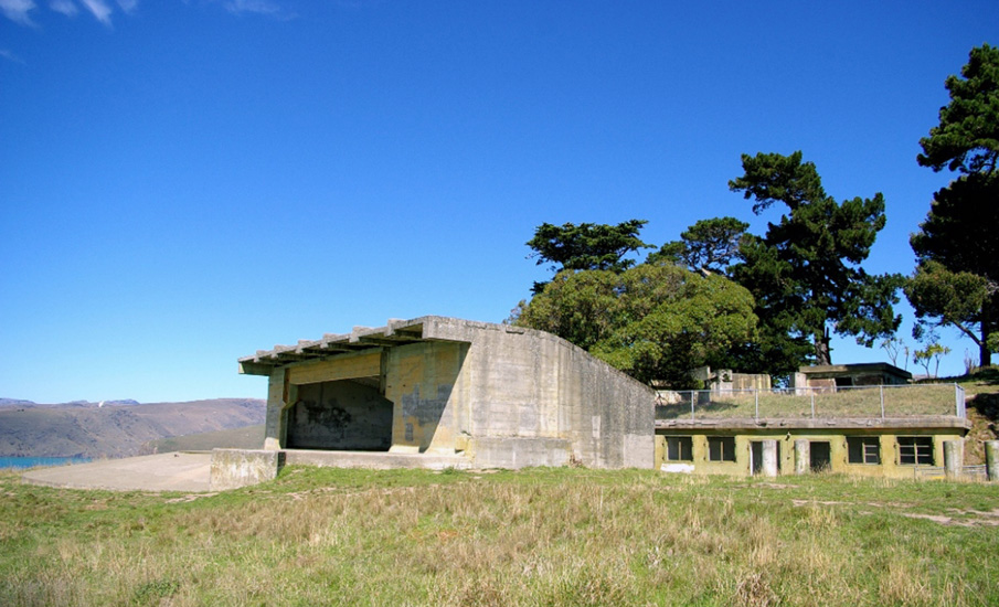
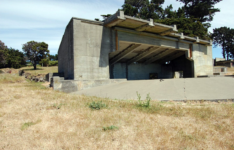
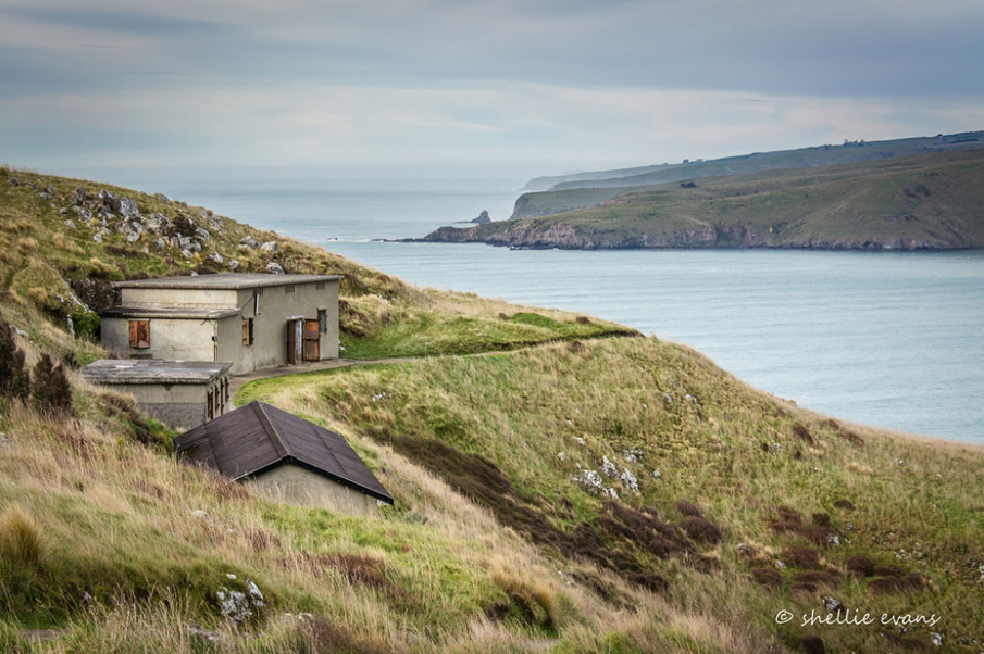
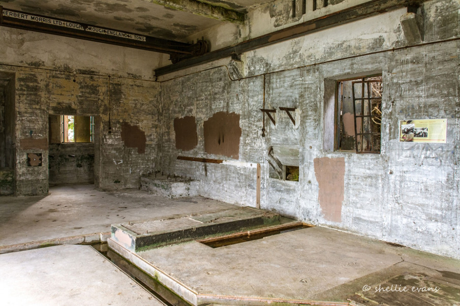
Date: 1939-46 Architect: Public Works Department supervision Style Code: MIL 14: World War II Coastal Defence Batteries, 1942-45 Contractor for early structures: Alan Moore, Christchurch The World War II defence installations which survive at Godley Head illustrate the complex provisions made to protect Lyttelton Harbour (and the South Island as a whole) from invasion. The principal features were the gun emplacements themselves, aligned at the cliff edge. Initially there were the Taylor Battery guns and then the main Godley battery which was the last New Zealand coastal defence installation to closely follow the War Office design. The first two emplacements built had the Colchester type overhead cover which restricted fire. However the last emplacement built had no cover and allowed a full 360° arc of fire, similar to those at 9.2 inch batteries elsewhere. Also, in common with the 9.2 inch emplacements, the last emplacement included a modest pump chamber to provide hydraulic power. The emplacements remain in fairly good condition but the underground magazines and war shelters have suffered from vandalism. Used in conjunction with these were the supporting defence structures. These included Battery Observation Points, Radar Stations, Searchlight emplacements and the Battery Plotting Room. Because this was such an important battery and camp, further protection was provided by a range of defensive positions and lookouts. Above the beach and on the headline some of the traditional pillboxes were located as well as some slit trenches which are relatively rare in New Zealand. Strong points (small concrete shelters) were also built on the hill above potential landing sites. As further information about the site is gathered, particularly through the activities of the recently formed Godley Heritage Trust, the identification of items of interest continues to grow. The camp which was established to house the forces' personnel was extensive. Water was fed by gravity from the supply provided to Taylors Mistake to the Black Point reservoir (No. 111 on site map) and then pumped to two large reservoirs (Nos. 53 and 54 ) for the camp's water supply. The camp provided barrack blocks, officers' quarters and houses for senior ranks. There were ablution and latrine blocks, kitchen facilities, mess, recreation and store buildings. Timber structures were later relocated for use elsewhere and it is only their foundations which remain alongside the concrete buildings to provide evidence of the camp's extent. The entire battery complex has very considerable significance. Virtually every structure built of concrete at Godley Head during World War II has survived. Still extant are: officers' mess, regimental headquarters and the quartermaster's store, former medical inspection building, miniature range building, radar stations, engine shed, three BOPs and, on the shore, two searchlight emplacements. The latter were reached by a winding path and a 120 metre long tunnel. The officers' mess in particular, remains in splendid condition. It is virtually untouched from when it was first built and retains the beds from the Compulsory Military Training (CMT) period of usage. It is a remarkably authentic 1940s government built structure. Most structures were built of concrete and some have pitched corrugated asbestos roofs, while others have flat concrete roofs covered with mastic, asphalt and soil. Their survival can be attributed to the use of concrete as the complex's basic building material and this usage has also ensured the retention of as comprehensive a group of associated structures as can be found at any battery site in New Zealand. The buildings remain in predominantly fine condition but vandalism has taken its toll on those buildings even a short distance from the main camp buildings. The use of concrete meant that the army's usual practice of relocating associated buildings from battery installations could not be completely implemented here. An attempt to blow up one of the two Taylor Batteries proved so difficult it was abandoned. With the removal or demolition of most of the structures associated with World War II Batteries elsewhere around New Zealand Godley Head is probably the most complete battery and camp complex in New Zealand. Current Physical Condition: The current condition of the remaining structures is generally sound though in many instances there is minor impact from vandalism and lack of maintenance. The goal of DOC staff is to lessen the pace of natural decline of physical condition.
Date: 1939-46 Architect: Public Works Department supervision Style Code: MIL 14: World War II Coastal Defence Batteries, 1942-45 Contractor for early structures: Alan Moore, Christchurch The World War II defence installations which survive at Godley Head illustrate the complex provisions made to protect Lyttelton Harbour (and the South Island as a whole) from invasion. The principal features were the gun emplacements themselves, aligned at the cliff edge. Initially there were the Taylor Battery guns and then the main Godley battery which was the last New Zealand coastal defence installation to closely follow the War Office design. The first two emplacements built had the Colchester type overhead cover which restricted fire. However the last emplacement built had no cover and allowed a full 360° arc of fire, similar to those at 9.2 inch batteries elsewhere. Also, in common with the 9.2 inch emplacements, the last emplacement included a modest pump chamber to provide hydraulic power. The emplacements remain in fairly good condition but the underground magazines and war shelters have suffered from vandalism. Used in conjunction with these were the supporting defence structures. These included Battery Observation Points, Radar Stations, Searchlight emplacements and the Battery Plotting Room. Because this was such an important battery and camp, further protection was provided by a range of defensive positions and lookouts. Above the beach and on the headline some of the traditional pillboxes were located as well as some slit trenches which are relatively rare in New Zealand. Strong points (small concrete shelters) were also built on the hill above potential landing sites. As further information about the site is gathered, particularly through the activities of the recently formed Godley Heritage Trust, the identification of items of interest continues to grow. The camp which was established to house the forces' personnel was extensive. Water was fed by gravity from the supply provided to Taylors Mistake to the Black Point reservoir (No. 111 on site map) and then pumped to two large reservoirs (Nos. 53 and 54 ) for the camp's water supply. The camp provided barrack blocks, officers' quarters and houses for senior ranks. There were ablution and latrine blocks, kitchen facilities, mess, recreation and store buildings. Timber structures were later relocated for use elsewhere and it is only their foundations which remain alongside the concrete buildings to provide evidence of the camp's extent. The entire battery complex has very considerable significance. Virtually every structure built of concrete at Godley Head during World War II has survived. Still extant are: officers' mess, regimental headquarters and the quartermaster's store, former medical inspection building, miniature range building, radar stations, engine shed, three BOPs and, on the shore, two searchlight emplacements. The latter were reached by a winding path and a 120 metre long tunnel. The officers' mess in particular, remains in splendid condition. It is virtually untouched from when it was first built and retains the beds from the Compulsory Military Training (CMT) period of usage. It is a remarkably authentic 1940s government built structure. Most structures were built of concrete and some have pitched corrugated asbestos roofs, while others have flat concrete roofs covered with mastic, asphalt and soil. Their survival can be attributed to the use of concrete as the complex's basic building material and this usage has also ensured the retention of as comprehensive a group of associated structures as can be found at any battery site in New Zealand. The buildings remain in predominantly fine condition but vandalism has taken its toll on those buildings even a short distance from the main camp buildings. The use of concrete meant that the army's usual practice of relocating associated buildings from battery installations could not be completely implemented here. An attempt to blow up one of the two Taylor Batteries proved so difficult it was abandoned. With the removal or demolition of most of the structures associated with World War II Batteries elsewhere around New Zealand Godley Head is probably the most complete battery and camp complex in New Zealand. Current Physical Condition: The current condition of the remaining structures is generally sound though in many instances there is minor impact from vandalism and lack of maintenance. The goal of DOC staff is to lessen the pace of natural decline of physical condition.
Historical and Associated Iwi / Hapū / Whānau
Completion Date
1st September 2004
Report Written By
Pam Wilson
Information Sources
Archives New Zealand (Chch)
Archives New Zealand (Christchurch)
Buckley, 1984
D. A. Buckley (ed), 'Godley Head and Battery Point: A History of Coastal defence during World War II', Ministry of Defence, 1984
Cooke, 2000
P. Cooke, Defending New Zealand; Ramparts on the Sea 1840-1950s, Wellington, 2000
Department of Conservation
Department of Conservation
New Zealand Historic Places Trust (NZHPT)
New Zealand Historic Places Trust
Other Information
A fully referenced version of this report is available from the NZHPT Southern Region Office. Please note that entry on the New Zealand Heritage List/Rarangi Korero identifies only the heritage values of the property concerned, and should not be construed as advice on the state of the property, or as a comment of its soundness or safety, including in regard to earthquake risk, safety in the event of fire, or insanitary conditions.
Current Usages
Uses: Civic Facilities
Specific Usage: Recreation Reserve/Scenic Reserve
Former Usages
General Usage: Defence
Specific Usage: Gun Emplacement
Themes
Coastal Defences
Current Usages
Uses: Civic Facilities
Specific Usage: Recreation Reserve/Scenic Reserve
Former Usages
General Usage: Defence
Specific Usage: Gun Emplacement
Themes
Coastal Defences
Location
Related listings

Sign up to hear more
Get the latest heritage news, features and events delivered
straight to your inbox.
