

Whaling was the first large-scale profitable commercial activity undertaken in New Zealand. The industry had a considerable impact on both the local economy and the coastal populations of Maori and Pakeha. Early Kapiti whalers operated in very tense times as Te Rauparaha and his nephew Te Rangihaeata were asserting their influence. The whalers and other traders were considered useful by the Ngati Toa chiefs and their settlement on the Island was encouraged. Te Kahuoterangi itself was the site of a Maori settlement and it is possible that it was occupied at the same time that the whaling station was in operation.
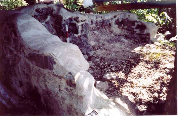
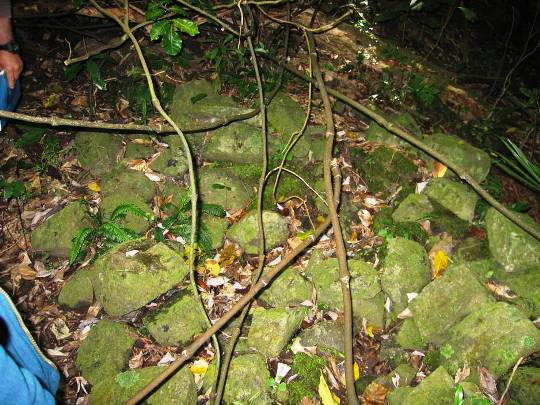
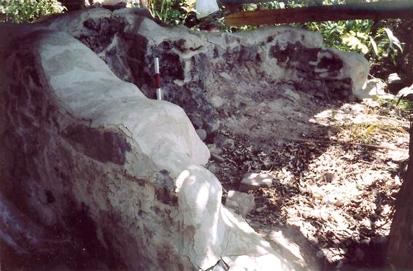
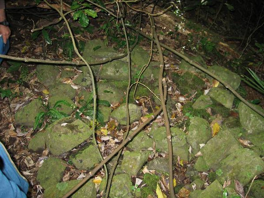
The structural remains of Te Kahuoterangi are considered to be the most intact of any of the shore whaling stations in New Zealand. The remains of try pot C are roughly two thirds intact, while one wall remains of try pot D. Additionally, terraces, stone alignments, fireplaces, midden and a grave have been identified.
Te Kahuoterangi has very high archaeological values. As an early European settlement it has the potential to provide information on the way of life of its former occupants and the interaction between Maori and Pakeha during this period of early contact and cultural change. The site also provides valuable information about whaling station operations and the arrangement of the shore works and accommodation.
List Entry Information
Status
Listed
List Entry Status
Historic Place Category 1
Access
Able to Visit
List Number
7662
Date Entered
30th June 2006
Date of Effect
30th June 2006
City/District Council
Kāpiti Coast District
Region
Wellington Region
Extent of List Entry
The registration includes part of the land on Section 3 Block 1, Kapiti Survey District, SO 28650, described in NZ Gazette 1973, p.1381, and the archaeological site that consists of the remains of the shore whaling station known as Te Kahuoterangi thereon.
Legal description
Sec 3 Blk 1 Kapiti SD, SO 28650 ('Nature Reserve', NZ Gazette 1973, p.1381)
Location Description
Te Kahuoterangi is located on the east side of Kapiti Island, at the mouth of Te Kahuoterangi Stream, 800 metres south of Waiorua. It extends 200 metres along a 20 metre-wide shore platform, beneath the steep hills on both sides of the stream, and also 100 metres up the stream gorge.
Why is this place significant?
Cultural Significance
Kapiti Island generally is of high cultural importance. It is associated with many tribal stories and histories of the tribes of the lower North Island. The island became well-known as the strong-hold of Te Rauparaha and his allies after 1832. This site of Te Kahuoterangi Whaling Station is believed to have been the location of a Maori village which may have been occupied at the same time as the station, but may also have been earlier. It is likely that Maori were involved in the whaling operations.
Historic Significance
Historical Significance or Value Te Kahuoterangi was one of a number of shore whaling stations that were set up on the New Zealand coast from the late 1820s. Kapiti Island was the centre of an active whaling industry, mainly shore-based. Whaling was the first large-scale profitable commercial activity undertaken in New Zealand and it had a considerable impact on both the local economy and the coastal populations of Pakeha and Maori. Kapiti Island was one of many places where the local population of traders and Maori were inter-dependent. In fact, early Kapiti whalers operated during very tense times. Te Rauparaha and his nephew Rangihaeata were asserting their dominance over a wide area of the country. The whalers and other traders were considered very useful by the Ngati Toa chiefs and their settlement on the island was encouraged.
Physical Significance
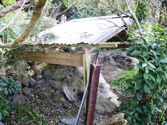
The site has high archaeological values. It is one of the most intact shore whaling stations in New Zealand and is identified by Prickett as one of 13 outstanding sites in his national survey of archaeological sites associated with shore whaling. Te Kahuoterangi has the potential to provide information about early European settlement of New Zealand and aspects of the material culture of the period; it can provide information about whaling practices and the operation of a whaling station and, most importantly, may be able to shed light on the initial contact between Maori and Europeans.
Why is this place Category 1 / Category 2?
Detail Of Assessed Criteria
(a) The extent to which the place reflects important or representative aspects of New Zealand history: On a specific level it is difficult to determine the significance of Te Kahuoterangi, simply as a whaling station because all that is presently known about the place has been gleaned from visual observation. It was obviously not a large place, few whaling stations were, but it clearly had a number of dwellings and possibly up to four trypot stands. It can be regarded, however, as a most important representative of a Kapiti and New Zealand shore whaling station from the heyday of the industry. There are no recorded surface structures associated with very early New Zealand whaling more substantial than those at Te Kahuoterangi. In particular the remaining upright trypot stand, although modest, is one of the few substantially intact structures of any built in the heyday of early whaling. The NZHPT currently has only one other whaling station on its register. This is the site of Korohiwa at Porirua for which there is currently no information held (Cat II, #6162). This means that places associated with 19th century whaling are currently enormously under-represented on the NZHPT's Register. Prickett identifies 87 shore whaling sites in New Zealand and describes 13 of them as outstanding. (b) The association of the place with events, persons, or ideas of importance in New Zealand history: Te Kahuoterangi was one of a series of shore whaling stations established in the Cook Strait region in the middle of the 19th century. Whaling was an important economic activity during the early European settlement of New Zealand. The arrival of the whalers also signalled an important period of interaction between Maori and Europeans and in many districts the first European settlers were shore whalers. These whalers relied on Maori for food, boat crews, wives, and protection from other Maori. At the same time, Maori were exposed to new technology and ideas, including commercial opportunities. (c) The potential of the place to provide knowledge of New Zealand history: The remains of Te Kahuoterangi have the potential to provide valuable information of the way of life of the people living at these early shore whaling stations. Of particular importance is the relationship between the whalers and local Maori. (d) The importance of the place to the tangata whenua: The site of the whaling station is also recorded as the site of a Maori village although it is not clear whether the two were contemporaneous. MacLean believes that Ngati Toa shared this settlement with the whalers. The chiefs Te Mahota and Tungia are described as the 'best-known residents' and both were connected through marriage with Europeans. Local Maori also have a connection with the place through the story of Te Rauoterangi and her swim across the channel between the island and the mainland. (f) The potential of the place for public education: The site is located on Crown land and is actively managed by the Department of Conservation. The site is currently closed to visitors but its potential as an educational resource remains. The intactness of the structures means that the site can easily be interpreted and appreciated by visitors. (I) Te Kahuoterangi is certainly not the earliest shore whaling station in New Zealand. However, it appears to have been operating in the late 1830s - early 1840s which means that it forms part of the earliest period of European settlement in the country. The whaling station at Te Awaiti in Tory Channel is perhaps one of the best known early whaling stations. This site, however, has been occupied since the mid-19th century and therefore has been extensively modified over the last 150 years. There is now little surface evidence other than headstones and a couple of trypots. The intact nature of Te Kahuoterangi, therefore, means that it also has the potential to provide valuable information about the way of life of these early settlers. (j) The importance of identifying historic places known to date from early periods of New Zealand settlement: The intact nature of the remnant structures of Te Kahuoterangi is extremely rare. Additionally, it is an early site containing evidence of interaction between Maori and Europeans. The 19th century whaling operations had a significant impact on whale numbers and by the 1840s many shore-whaling stations had ceased to operate. Sites such as Te Kahuoterangi that date from the heyday of shore-whaling in New Zealand can, therefore, provide a snapshot of life in the 1830s and 1840s as a discrete subset of industrial activity during the early European settlement phase. (k) The extent to which the place forms part of a wider historical and cultural complex or historical and cultural landscape: This site forms part of a wider landscape of whaling activities in the Cook Strait region. It is one of three stations established on Kapiti Island. There are known stations on the small islands just off Kapiti and shore stations were also located on the Porirua coast. The site also appears to be connected with the activities of Te Rauparaha and Rangihaeata in the region.
Why is this place significant?
Cultural Significance
Kapiti Island generally is of high cultural importance. It is associated with many tribal stories and histories of the tribes of the lower North Island. The island became well-known as the strong-hold of Te Rauparaha and his allies after 1832. This site of Te Kahuoterangi Whaling Station is believed to have been the location of a Maori village which may have been occupied at the same time as the station, but may also have been earlier. It is likely that Maori were involved in the whaling operations.
Historic Significance
Historical Significance or Value Te Kahuoterangi was one of a number of shore whaling stations that were set up on the New Zealand coast from the late 1820s. Kapiti Island was the centre of an active whaling industry, mainly shore-based. Whaling was the first large-scale profitable commercial activity undertaken in New Zealand and it had a considerable impact on both the local economy and the coastal populations of Pakeha and Maori. Kapiti Island was one of many places where the local population of traders and Maori were inter-dependent. In fact, early Kapiti whalers operated during very tense times. Te Rauparaha and his nephew Rangihaeata were asserting their dominance over a wide area of the country. The whalers and other traders were considered very useful by the Ngati Toa chiefs and their settlement on the island was encouraged.
Physical Significance
The site has high archaeological values. It is one of the most intact shore whaling stations in New Zealand and is identified by Prickett as one of 13 outstanding sites in his national survey of archaeological sites associated with shore whaling. Te Kahuoterangi has the potential to provide information about early European settlement of New Zealand and aspects of the material culture of the period; it can provide information about whaling practices and the operation of a whaling station and, most importantly, may be able to shed light on the initial contact between Maori and Europeans.
Why is this place Category 1 / Category 2?
Detail Of Assessed Criteria
(a) The extent to which the place reflects important or representative aspects of New Zealand history: On a specific level it is difficult to determine the significance of Te Kahuoterangi, simply as a whaling station because all that is presently known about the place has been gleaned from visual observation. It was obviously not a large place, few whaling stations were, but it clearly had a number of dwellings and possibly up to four trypot stands. It can be regarded, however, as a most important representative of a Kapiti and New Zealand shore whaling station from the heyday of the industry. There are no recorded surface structures associated with very early New Zealand whaling more substantial than those at Te Kahuoterangi. In particular the remaining upright trypot stand, although modest, is one of the few substantially intact structures of any built in the heyday of early whaling. The NZHPT currently has only one other whaling station on its register. This is the site of Korohiwa at Porirua for which there is currently no information held (Cat II, #6162). This means that places associated with 19th century whaling are currently enormously under-represented on the NZHPT's Register. Prickett identifies 87 shore whaling sites in New Zealand and describes 13 of them as outstanding. (b) The association of the place with events, persons, or ideas of importance in New Zealand history: Te Kahuoterangi was one of a series of shore whaling stations established in the Cook Strait region in the middle of the 19th century. Whaling was an important economic activity during the early European settlement of New Zealand. The arrival of the whalers also signalled an important period of interaction between Maori and Europeans and in many districts the first European settlers were shore whalers. These whalers relied on Maori for food, boat crews, wives, and protection from other Maori. At the same time, Maori were exposed to new technology and ideas, including commercial opportunities. (c) The potential of the place to provide knowledge of New Zealand history: The remains of Te Kahuoterangi have the potential to provide valuable information of the way of life of the people living at these early shore whaling stations. Of particular importance is the relationship between the whalers and local Maori. (d) The importance of the place to the tangata whenua: The site of the whaling station is also recorded as the site of a Maori village although it is not clear whether the two were contemporaneous. MacLean believes that Ngati Toa shared this settlement with the whalers. The chiefs Te Mahota and Tungia are described as the 'best-known residents' and both were connected through marriage with Europeans. Local Maori also have a connection with the place through the story of Te Rauoterangi and her swim across the channel between the island and the mainland. (f) The potential of the place for public education: The site is located on Crown land and is actively managed by the Department of Conservation. The site is currently closed to visitors but its potential as an educational resource remains. The intactness of the structures means that the site can easily be interpreted and appreciated by visitors. (I) Te Kahuoterangi is certainly not the earliest shore whaling station in New Zealand. However, it appears to have been operating in the late 1830s - early 1840s which means that it forms part of the earliest period of European settlement in the country. The whaling station at Te Awaiti in Tory Channel is perhaps one of the best known early whaling stations. This site, however, has been occupied since the mid-19th century and therefore has been extensively modified over the last 150 years. There is now little surface evidence other than headstones and a couple of trypots. The intact nature of Te Kahuoterangi, therefore, means that it also has the potential to provide valuable information about the way of life of these early settlers. (j) The importance of identifying historic places known to date from early periods of New Zealand settlement: The intact nature of the remnant structures of Te Kahuoterangi is extremely rare. Additionally, it is an early site containing evidence of interaction between Maori and Europeans. The 19th century whaling operations had a significant impact on whale numbers and by the 1840s many shore-whaling stations had ceased to operate. Sites such as Te Kahuoterangi that date from the heyday of shore-whaling in New Zealand can, therefore, provide a snapshot of life in the 1830s and 1840s as a discrete subset of industrial activity during the early European settlement phase. (k) The extent to which the place forms part of a wider historical and cultural complex or historical and cultural landscape: This site forms part of a wider landscape of whaling activities in the Cook Strait region. It is one of three stations established on Kapiti Island. There are known stations on the small islands just off Kapiti and shore stations were also located on the Porirua coast. The site also appears to be connected with the activities of Te Rauparaha and Rangihaeata in the region.
Construction Details
Start Year
1839
startYearCirca
Type
Original Construction
Description
In operation by this date.
Start Year
1843
startYearCirca
Type
Other
Description
Final year of operation.
Notable Features
Identified features of the whaling station include: 1. Prickett's terraces 2. Pre-European terrace at GR 735 387 (off the site map but regarded as part of the historic place) 3. Stone heap 4. Terrace/house floor 5. Terrace/house floor 6. Terrace/house floor 7. Terrace 1/house floor/fireplace 8. Terrace scarp 2/house floor/fireplace 9. Terrace scarp 3 (collapsed)/house floor/fireplace 10. Midden 11. House floor 4/fireplace 12. Collapsed midden 13. House floor 5/fireplace 14. Terrace 6/house floor/fireplace 15. Pit 16. Midden 17. Trypot stand? (Trypot A) 18. Trypot stand? (Trypot B) 19. Trypot stand (Trypot C) 20. Trypot stand? (Trypot D) 21. Terrace 7/housefloor/fireplace 22. Telegraph/telephone pole 23. Grave 24. Maori house (marked by a stone hearth) 25. Terrace scarp 26. Terrace scarp 27. Terrace scarp 28. Yankee Lookout
In the 1820s, Ngati Toa leader Te Rauparaha (?-1849) and his allies established themselves on Kapiti Island. Soon after, European traders arrived to conduct business. They were encouraged to visit by Te Rauparaha who displayed a keen business sense. His principle interest was guns, for which he traded large amounts of flax. Traders were soon followed by shore whalers who operated from both Kapiti Island and the mainland. Whaling was the first large-scale profitable commercial activity undertaken in New Zealand and had a considerable impact on both the local economy and the coastal populations of Maori and Pakeha. One of the first shore whaling establishment in the Cook Strait area was John Guard's station established around 1827 at Te Awaiti, in the Marlborough Sounds. The whaling industry at Kapiti was, as in most of New Zealand, relatively short-lived. Whaling companies, mostly Sydney based, set up stations on the Island and ran their own ships to collect the oil. The first station on Kapiti Island, Richards and Co., was established around 1830. By the winter of 1831, there were reports of as many as four ships calling at the island at one time. Other stations, including 'Te Kahuoterangi' were established on Kapiti Island itself and on islands just off the east coast of the Island. Little is known about the occupation of these stations. In contemporary accounts such as Wakefield, references are made to shore stations and the men who ran them, but these names are rarely linked with specific places. It is also never quite clear whether Kapiti refers to the main island alone or incorporates the small off-shore islands. In 1837, two whaling stations and plant belonging to Messrs Wright and Long were advertised for sale by public auction in Sydney. One was at "Wycatti" or Entry Island, the other at 'Capertee' or Kapiti Island, although Entry and Kapiti Islands were generally one and the same thing. In 1839, Captain William Barnard Rhodes also established a shore whaling station on Kapiti Island, which was managed by Thomas Wright. That same year Ernst Dieffenbach, a natural scientist on a New Zealand Company expedition, reported just two shore stations operating on Kapiti Island itself, plus a number on the off-shore islands. One Kapiti Island station was managed by John Nichol, who later married Te Rauoterangi, the daughter of a Ngati Toa chief on Kapiti Island. Morton suggests that some of the Kapiti stations were established or managed by American whaleship captains and indeed, close to Te Kahuoterangi was a promontory known as 'Yankee Lookout'. Two American whaling stations, Mayhew's and Lewis's respectively, were established on two of the small islands off Kapiti, Tahoramaura and Motungara. The latter information comes from McNab who also suggests that, in 1839, there was just the one station on Kapiti Island itself. This station may have been Gillet's (now spelt 'Jillett'). Situated less than a kilometre north of Te Kahuoterangi, at Waiorua, Gillet's whaling station was the subject of a well-known watercolour by Bowring from a pencil sketch by J.A. Gilfillian (1844). It was a substantial European settlement with a population estimated as many as 150 people, including local Maori. The illustration provides insight into the types of dwelling likely to have been built at Te Kahuoterangi. Te Kahuoterangi was the site of a Maori village which may have existed the same time as the whaling station but could easily have been occupied earlier. Early maps of Kapiti Island describe Te Kahuoterangi as the 'site of old whaling station'. Later maps also describe it as the site of a Maori village. Carkeek describes it as the site of a Maori village and makes no mention of its role as a whaling station. The exact date that the Whaling Station was established is unknown but it appears to have been in operation by 1839 and, by 1843, was a station of several boats. Its catch statistics are not listed in The New Zealand Spectator and Cook's Guardian for 1844, so it is probable that 1843 was its final year in operation. As early as 1905, Te Kahuoterangi was the most visible abandoned whaling station remaining on Kapiti Island. That year Cowan described the sites of the houses of both whalers and Maori on both sides of the Te Kahuoterangi stream, 'with the old stone chimneys that denote the huts of the Europeans'. No mention was made of trypot stands. Today, stone floors and hearths show where dwellings were originally located, while scattered whalebones indicate the function of the former settlement. Importantly, the station also retains a number of the trypot stands, which are now very rare. Work has been carried out to protect these structures and the site, which is not accessible to the public, is managed by the Department of Conservation.
In the 1820s, Ngati Toa leader Te Rauparaha (?-1849) and his allies established themselves on Kapiti Island. Soon after, European traders arrived to conduct business. They were encouraged to visit by Te Rauparaha who displayed a keen business sense. His principle interest was guns, for which he traded large amounts of flax. Traders were soon followed by shore whalers who operated from both Kapiti Island and the mainland. Whaling was the first large-scale profitable commercial activity undertaken in New Zealand and had a considerable impact on both the local economy and the coastal populations of Maori and Pakeha. One of the first shore whaling establishment in the Cook Strait area was John Guard's station established around 1827 at Te Awaiti, in the Marlborough Sounds. The whaling industry at Kapiti was, as in most of New Zealand, relatively short-lived. Whaling companies, mostly Sydney based, set up stations on the Island and ran their own ships to collect the oil. The first station on Kapiti Island, Richards and Co., was established around 1830. By the winter of 1831, there were reports of as many as four ships calling at the island at one time. Other stations, including 'Te Kahuoterangi' were established on Kapiti Island itself and on islands just off the east coast of the Island. Little is known about the occupation of these stations. In contemporary accounts such as Wakefield, references are made to shore stations and the men who ran them, but these names are rarely linked with specific places. It is also never quite clear whether Kapiti refers to the main island alone or incorporates the small off-shore islands. In 1837, two whaling stations and plant belonging to Messrs Wright and Long were advertised for sale by public auction in Sydney. One was at "Wycatti" or Entry Island, the other at 'Capertee' or Kapiti Island, although Entry and Kapiti Islands were generally one and the same thing. In 1839, Captain William Barnard Rhodes also established a shore whaling station on Kapiti Island, which was managed by Thomas Wright. That same year Ernst Dieffenbach, a natural scientist on a New Zealand Company expedition, reported just two shore stations operating on Kapiti Island itself, plus a number on the off-shore islands. One Kapiti Island station was managed by John Nichol, who later married Te Rauoterangi, the daughter of a Ngati Toa chief on Kapiti Island. Morton suggests that some of the Kapiti stations were established or managed by American whaleship captains and indeed, close to Te Kahuoterangi was a promontory known as 'Yankee Lookout'. Two American whaling stations, Mayhew's and Lewis's respectively, were established on two of the small islands off Kapiti, Tahoramaura and Motungara. The latter information comes from McNab who also suggests that, in 1839, there was just the one station on Kapiti Island itself. This station may have been Gillet's (now spelt 'Jillett'). Situated less than a kilometre north of Te Kahuoterangi, at Waiorua, Gillet's whaling station was the subject of a well-known watercolour by Bowring from a pencil sketch by J.A. Gilfillian (1844). It was a substantial European settlement with a population estimated as many as 150 people, including local Maori. The illustration provides insight into the types of dwelling likely to have been built at Te Kahuoterangi. Te Kahuoterangi was the site of a Maori village which may have existed the same time as the whaling station but could easily have been occupied earlier. Early maps of Kapiti Island describe Te Kahuoterangi as the 'site of old whaling station'. Later maps also describe it as the site of a Maori village. Carkeek describes it as the site of a Maori village and makes no mention of its role as a whaling station. The exact date that the Whaling Station was established is unknown but it appears to have been in operation by 1839 and, by 1843, was a station of several boats. Its catch statistics are not listed in The New Zealand Spectator and Cook's Guardian for 1844, so it is probable that 1843 was its final year in operation. As early as 1905, Te Kahuoterangi was the most visible abandoned whaling station remaining on Kapiti Island. That year Cowan described the sites of the houses of both whalers and Maori on both sides of the Te Kahuoterangi stream, 'with the old stone chimneys that denote the huts of the Europeans'. No mention was made of trypot stands. Today, stone floors and hearths show where dwellings were originally located, while scattered whalebones indicate the function of the former settlement. Importantly, the station also retains a number of the trypot stands, which are now very rare. Work has been carried out to protect these structures and the site, which is not accessible to the public, is managed by the Department of Conservation.
General Description The site is located on the Kahuoterangi Stream fan, which emerges from a steep gully about 70 metres inland from the high water mark. The fan is approximately 40 x 40m, with a prominent slope down to the narrow coastal strip. This strip fronts a very steep hillside. A 1972 survey of Kapiti Island recorded seven stone fireplaces, the remains of four stone buildings, one round pit and extensive midden in the north bank of the stream. Clay plaster was observed on some of the stone buildings. A whale vertebra and piece of hoop iron were recorded on the beach just south of the stream mouth. Previous visits to the site had recorded up to twenty fireplaces scattered over an area of half an acre and the presence of part of a whale skeleton on the beach. Site Features Terraces are cut into the foot of the hill slope, south and north of the stream, the foot of the western slope, and by the track as it rises to the north of the flat strip 150 metres from the stream. Irregular stone alignments mark house floors to the south of the stream and a grave at the foot of the slope 50 metres north of the stream. In addition, there are also irregular stone heaps, beach-boulder, stone-block and carved pumice block fireplaces. Some of these are free standing but most are associated with terrace sites. At the eastern end of the site and north of the stream there are further irregular stone heaps and clay-set stone trypot stands. A shell midden is exposed on the north bank of the stream. There are also likely to be sub-surface archaeological remains associated with the identified archaeological features. Trypot Structures Trypot stand C is a rounded 'w' in plan form on the interior and a 'u' shape on the exterior. It is approximately 3600mm wide and 1700mm long with a depth of 900mm. It is constructed of local greywacke boulders and earth mortar. The exterior of the structure appears to have been rendered with an earth render. The heat of the fire seems to have fired the interior earth render. Almost two thirds of the structure appears to be intact. Vegetation has been removed. It has also been grouted, stabilized and replastered. The other try-work stands are much less intact. Trypot stand D, for instance, has only one wall remaining. These features may in fact be huts, rather than try-works. Grave The grave site is marked by a line of greywacke stones laid directly on the ground in the form of a rectangle. Fireplaces The fireplaces are constructed with greywacke or pumice in dry stone walling.
General Description The site is located on the Kahuoterangi Stream fan, which emerges from a steep gully about 70 metres inland from the high water mark. The fan is approximately 40 x 40m, with a prominent slope down to the narrow coastal strip. This strip fronts a very steep hillside. A 1972 survey of Kapiti Island recorded seven stone fireplaces, the remains of four stone buildings, one round pit and extensive midden in the north bank of the stream. Clay plaster was observed on some of the stone buildings. A whale vertebra and piece of hoop iron were recorded on the beach just south of the stream mouth. Previous visits to the site had recorded up to twenty fireplaces scattered over an area of half an acre and the presence of part of a whale skeleton on the beach. Site Features Terraces are cut into the foot of the hill slope, south and north of the stream, the foot of the western slope, and by the track as it rises to the north of the flat strip 150 metres from the stream. Irregular stone alignments mark house floors to the south of the stream and a grave at the foot of the slope 50 metres north of the stream. In addition, there are also irregular stone heaps, beach-boulder, stone-block and carved pumice block fireplaces. Some of these are free standing but most are associated with terrace sites. At the eastern end of the site and north of the stream there are further irregular stone heaps and clay-set stone trypot stands. A shell midden is exposed on the north bank of the stream. There are also likely to be sub-surface archaeological remains associated with the identified archaeological features. Trypot Structures Trypot stand C is a rounded 'w' in plan form on the interior and a 'u' shape on the exterior. It is approximately 3600mm wide and 1700mm long with a depth of 900mm. It is constructed of local greywacke boulders and earth mortar. The exterior of the structure appears to have been rendered with an earth render. The heat of the fire seems to have fired the interior earth render. Almost two thirds of the structure appears to be intact. Vegetation has been removed. It has also been grouted, stabilized and replastered. The other try-work stands are much less intact. Trypot stand D, for instance, has only one wall remaining. These features may in fact be huts, rather than try-works. Grave The grave site is marked by a line of greywacke stones laid directly on the ground in the form of a rectangle. Fireplaces The fireplaces are constructed with greywacke or pumice in dry stone walling.
Historical and Associated Iwi / Hapū / Whānau
Completion Date
1st May 2006
Report Written By
Michael Kelly with Emma Brooks
Information Sources
Auckland Institute & Museum
Auckland Institute & Museum
Carkeek, 1967
W. W. Carkeek, The Kapiti Coast; Maori History and Place Names of the Paekakariki-Otaki District, Auckland, 1967 (2nd ed. 2004).
Prickett, 2002
N. Prickett, 'The Archaeology of New Zealand Shore Whaling', Department of Conservation, Wellington, 2002.
Other Information
'Nature Reserve', New Zealand Gazette 1973, p.1381. A fully referenced version of this report is available from the NZHPT Central Region Office. Please note that entry on the New Zealand Heritage List/Rarangi Korero identifies only the heritage values of the property concerned, and should not be construed as advice on the state of the property, or as a comment of its soundness or safety, including in regard to earthquake risk, safety in the event of fire, or insanitary conditions.
Current Usages
Uses: Civic Facilities
Specific Usage: Historic or recreation reserve
Former Usages
General Usage: Manufacturing
Specific Usage: Whaling Station
Themes
Of Significance to Maori
Current Usages
Uses: Civic Facilities
Specific Usage: Historic or recreation reserve
Former Usages
General Usage: Manufacturing
Specific Usage: Whaling Station
Themes
Of Significance to Maori
Location
Sign up to hear more
Get the latest heritage news, features and events delivered
straight to your inbox.
