

List Entry Information
Status
Listed
List Entry Status
Historic Place Category 2
Access
Private/No Public Access
List Number
7668
Date Entered
30th June 2006
Date of Effect
30th June 2006
City/District Council
Ruapehu District
Region
Horizons (Manawatū-Whanganui) Region
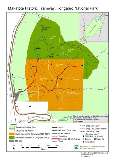
Extent of List Entry
Registration includes the archaeological remains and extant features of the whole of that area related to the sawmilling operation, thereby incorporating not only the tramway and associated features (skid sites, drag lines, water pits), but also the mill site and house sites. An archaeological survey has indicated that this area encompasses the land from State Highway 4 east to the foothills, from Makatote Stream gully in the south, to the Makomiko Stream in the north . Historical maps indicate that the tramway extended further to the northeast/east, beyond the stand of Chamaecyparis lawsoniana (Lawson Cypress) into Pt Waimarino 1, but no evidence of this could be found during the archaeological survey.
Legal description
Sec 1 Blk IX, Ruapehu SD. (Tongariro National Park: NZ Gazette, 1984, p.1679) [the tramway covers only that portion of Sec 1 Blk IX which is to the north of the Makatote River]; Pt Sec 9 Blk VIII, Manganui SD. (Scenic Reserve: NZ Gazette, 1914, p.4144)
Location Description
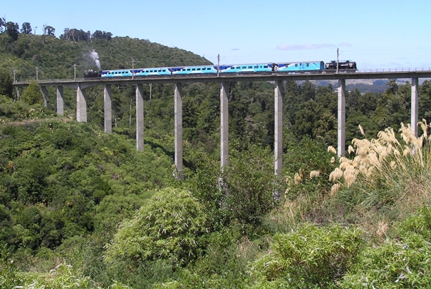
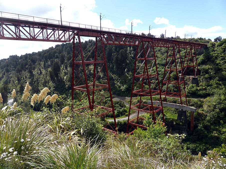
The Makatote Tramway is situated on the western boundary of the Tongariro National Park, approximately five kilometres south of Erua, and ten kilometres south of National Park, on State Highway 4 (see Appendix 2). It is accessed via a rough track that leads into the bush, just north of the Makatote Viaduct. Whilst this track is quite visible from the side of the road, the route through the bush to the beginning of the tramway is not clearly marked. Anyone visiting the tramway would need to be guided by someone who was familiar with the site.
Status
Listed
List Entry Status
Historic Place Category 2
Access
Private/No Public Access
List Number
7668
Date Entered
30th June 2006
Date of Effect
30th June 2006
City/District Council
Ruapehu District
Region
Horizons (Manawatū-Whanganui) Region
Extent of List Entry
Registration includes the archaeological remains and extant features of the whole of that area related to the sawmilling operation, thereby incorporating not only the tramway and associated features (skid sites, drag lines, water pits), but also the mill site and house sites. An archaeological survey has indicated that this area encompasses the land from State Highway 4 east to the foothills, from Makatote Stream gully in the south, to the Makomiko Stream in the north . Historical maps indicate that the tramway extended further to the northeast/east, beyond the stand of Chamaecyparis lawsoniana (Lawson Cypress) into Pt Waimarino 1, but no evidence of this could be found during the archaeological survey.
Legal description
Sec 1 Blk IX, Ruapehu SD. (Tongariro National Park: NZ Gazette, 1984, p.1679) [the tramway covers only that portion of Sec 1 Blk IX which is to the north of the Makatote River]; Pt Sec 9 Blk VIII, Manganui SD. (Scenic Reserve: NZ Gazette, 1914, p.4144)
Location Description
The Makatote Tramway is situated on the western boundary of the Tongariro National Park, approximately five kilometres south of Erua, and ten kilometres south of National Park, on State Highway 4 (see Appendix 2). It is accessed via a rough track that leads into the bush, just north of the Makatote Viaduct. Whilst this track is quite visible from the side of the road, the route through the bush to the beginning of the tramway is not clearly marked. Anyone visiting the tramway would need to be guided by someone who was familiar with the site.
Why is this place significant?
Historic Significance
Historical Significance or Value The Makatote Tramway is historically significant through its association with the founding years of the central North Island timber industry. Hundreds of bush tramways operated throughout the length of New Zealand from 1870s through to the mid 1900s, and there was a concentration of bush tramways throughout the various central North Island native forests. An undated map of the Erua State Forest shows 8 different tramways, including the Makatote Tramway (identified as 'Dinwoodie's Timber Company'). The particular history of the Makatote tramway also exemplifies that of the numerous small-scale sawmills that operated throughout the wider Ruapehu district during the early 1900s. Many of these mills were short-lived operations that were plagued with financial difficulties.
Physical Significance
Archaeological The Makatote Tramway has archaeological significance as one of the few remaining tramway sites in the Ruapehu region. There was a thriving sawmilling industry in this area during the first half of the twentieth century, but there has been a cumulative loss of these sites, and few survive today. Whilst the site is of fair condition, it is remarkably complete, with evidence of each of the various components of the operation, and how these changed over time. The Makatote Tramway also has clear potential for archaeological inquiry - excavation of the mill site for example could provide information about the size and structure of the mill, which is currently unknown. The tramway also possesses high interpretive value, with considerable potential for public education. It is easily accessible, and there is a wealth of historical and archaeological information that could be used for interpretation purposes such as the creation of a walking track. Scientific The Makatote Tramway has scientific value because of its setting in amongst Western Red Cedar and Lawson's Cypress which were planted in and around the tramway by the State Forests Service in the 1930s as part of a wider experimental high-altitude planting programme. Whilst these exotics are slowly being overtaken by native vegetation, they are still visible along parts of the tramway, and may possibly be the only remnant groves from the experimental programme. They are an integral part of the site; any commercial harvesting would have a detrimental effect upon the historical and archaeological values of the tramway. Technological Bush tramways played an integral role in the transportation of logs and sawn timber throughout New Zealand for almost a century. They often followed challenging routes and were known for their use of minimal construction, and equipment created with 'good old 'Kiwi ingenuity', using local sourced materials. Whilst the Makatote Tramway covers largely flat terrain, the presence of several watercourses required the creation of bridges, and causeways are also evident along the route. Other notable features include a points change and section of double tramline, but of particular significance is the presence of both wooden and metal rails, which appears to indicate a change in technology from horse power to rail tractor/steam haulage.
Why is this place Category 1 / Category 2?
Detail Of Assessed Criteria
(a) 'The extent to which the place reflects important or representative aspects of New Zealand history' The Makatote tramway reflects representative aspects of the timber and sawmilling industry that operated in the native forests of the central North Island during the early decades of the twentieth century. Like many other sawmills, the Makatote Tramway site reflects a relatively small business operation, employing less than 20 people, predominantly men, and it illustrates the ephemeral nature of such settlements that operated throughout the wider Ruapehu area. The Makatote tramway site also reflects the economic reality of the industry, as two companies failed in their operations at this site. (c)The potential of the place to provide knowledge of New Zealand history: The Makatote tramway has considerable potential to provide knowledge of New Zealand history. It is one of the few known sawmilling sites in the Ruapehu district that has remained relatively intact, and to date it is the best preserved example within the Tongariro National Park. There is a good historical record associated with the site, and there is the potential for archaeological investigation to contribute further important information about this industry during its peak in the 1920s to 1930s. (f)The potential of the place for public education: The Makatote Tramway site has excellent potential for public education, as it is part of the Tongariro National Park and is easily accessible from the main highway. Possible options for public education include interpretive signs, publications, walking trails and guided tours as part of recreation programmes. The creation of a walking track would provide a lower-altitude all-weather alternative to the popular, more-exposed, mountainous walks in the Park, and could be modelled on walking tracks like the Kauri Timber Company's tram on Great Barrier Island, or the Marlborough Timber Company's operations at Port Craig, both of which are maintained by the Department of Conservation. There is even potential for the development of a sawmilling heritage trail for the area which could picks up on some of the features that are missing from the Makatote Tramway site, such as the still-operating National Park sawmill, ex-sawmillers' cottages and mill manager houses at Horopito, and the Kaikawaka Villa (bushmen's hut) near Raurimu. (g)The technical accomplishment or value, or design of the place: Whilst the Makatote Tramway does not cover challenging terrain like other tramways such as the Kauri Timber Company's incline at Pupuke in Northland, it has value because of the range of technology that was used at the site, reflecting the changing nature of the sawmilling industry during this time. There are both wooden and metal rails evident throughout the site, and historical data indicates that a range of techniques were employed to haul logs out of the forest to the mill, including an RD6 Caterpillar, rail tractor, and steam powered log hauler. Evidence for the need of water for steam-driven machinery operations is seen in the various pits and water races, and the presence of corduroys along sections of the tramline may indicate the use of an R D 6 Caterpillar tractor for hauling logs. (k)The extent to which the place forms part of a wider historical and cultural complex or historical and cultural landscape: The Makatote tramway forms part of a wider historical complex that contains sites associated with the sawmilling industry of the Ohakune-Taumarunui area. Other sites in this complex include the ex-sawmillers' cottages and mill manager houses at Horopito, the Kaikawaka Villa (bushmen's hut) near Raurimu, and the nearby sawmill at National Park, which is still operating. The remains of another tramway were also recently recorded by DOC staff at Pokaka (further south between the Manganui o Te Ao and Mangaturuturu viaducts).
Construction Details
Start Year
1929
startYearCirca
Finish Year
1940
finishYearCirca
Type
Original Construction
Construction Materials
Wooden Tramway The wooden tramway was constructed by using totara rails (approximately 70 x 150mm), which were overlaid on rough sawn logs of varying diameters. The method of attachment was a substantial metal spike driven through both the rail and the underlying sleeper. The sleepers are spaced 1.2 metres apart and the gauge of the rails is approximately 1.25 metres
Notable Features
Wooden and metal tramway Skid sites Log hauler Water pits Mill remains Rubbish pits Bogey wheels Sawmilling artefacts
Information that the Makatote Tramway was constructed around 1905 has not been able to be substantiated. According to George Berry and other informants, the first people milling this piece of bush were the Pedersen family. Fifteen members of the Pedersen family had moved into the Waimarino District by 1914 setting up mills at Pakihi near Raetihi, and at Rangataua to the east of Ohakune. Charlie (Charles E.) Pedersen owned the Mangawhero Sawmilling Company at Karioi with two of his sons, Arthur W. and Alfred (Fred) E, and their wives were the principals of the Karioi Sawmilling Company Limited, which was incorporated on 19 December 1927. All were from Raetihi, and the men are listed as sawmillers. Evidently the company did not begin business operations until 17 January 1929, and the mill later closed down on 18 December 1931. The Karioi Sawmilling Company was struck off the Companies Register on 3 July 1934. The history of the Makatote site between the years 1931 to 1934 is unclear, but in 1934 the bush was surveyed, and J. Myles prepared timber-cruising sheets. Myles recorded the amount of available timber by surveying a line in Block VIII, Manganui Survey District, State Forest 67 and Block V, Ruapehu Survey District, State Forest 42. The species listed included: matai, miro, totara, rimu and kahikatea. It appears that land in Block VIII Manganui, State Forest 42 was also considered. The sale of the cutting area Lot 11 (immediately to the north of the area cut over by the Karioi Sawmilling Company) was advertised in the New Zealand Gazette on 13 September 1934, and two tenders were received, one from Mr Thomas Dinwoodie, a sawmiller who had mixed success in previous operations in the region, and one from Mr Edhouse of Crighton Brothers Limited in Ohakune. References from the Bank of New Zealand described Dinwoodie as a "reliable man in small way but appears to be doing fairly well at present. Providing he doesn't meet with a reverse consider him safe risk for 128 pound per month, over 37 months." His business associates D.G. and K.S. Glendinning were also considered reliable, and Dinwoodie's tender was accepted. Dinwoodie subsequently formed the Dinwoodie Timber Company with the Glendinning brothers, and in November 1934 he was issued with a sawmill license (No. 16/42/72) for Lot 11 of State Forest 42, Block VIII Manganui and Blk V Ruapehu Survey Districts, covering the period 18 October 1934 to 17 April 1939. The license allowed for the erection of a sawmill and the cutting of rimu, matai, kahikatea, totara and miro, estimated contents totalling 3,347,600 ft board measure and 500,810 ft, cubic measure. The purchase price was 5100 pound, of which Dinwoodie paid a deposit and his one guinea license fee. The balance was to be paid in 37 equal instalments by promissory notes. An attached schedule shows Lot 11 to be the northern area of the site encompassing the Makomiko Stream; the block to the south is marked as 'Karioi S.M. Co.'s Cut Over Area'. He was subsequently issued with a lease for part of SF 42 for the purposes of erecting a sawmill, backdated so that it was valid for the same 5-year period. The site was 2.86 acres in extent, being two irregular pieces of land adjacent and east of the main road and either side of the lay-by or road reserve. Dinwoodie was also required to obtain a tramway license, which was delayed. Director of Forestry A.D. McGavock stated that "the license in question is not comparable to an ordinary tramway license [as] the formation is already completed, the tram being the old tram of the Karioi Sawmilling Coy [and] the route traverses planted ground of what is in effect a regenerated and managed forest. It was considered that the original sawmilling unit "laid out and left to this Service a permanent asset...for use of which succeeding licensees must pay fees...and which they must maintain". The arrangement was seen as a test case for this relatively new situation of private tramways on Crown Land. Another modification to the draft license agreement was the reduction by 75% of the one chain right-of-way that "would give the right of destruction of many planted trees". However the extent of the tramway was corrected: "In connection with the formation, I would point out that this not already completed [sic], as the formation of the whole of the left hand branch and part of the right hand branch towards the eastern extremity had to be undertaken by the above sawmilling company [Dinwoodie Timber Co.]". The tramway license was finally issued on 24 September 1935, but was backdated to 18 October 1934. It was valid for 4.5 years and pertained to Lot 10 of State Forest No. 42. The license allowed the Dinwoodie Timber Company Limited "to occupy the land specified in the Schedule hereto as a tramway route for the purpose of using and maintaining a tram-line and running a tram thereon". An attached plan showed the extent of the existing tramway, which crossed the 'Bulls-Taumarunui Road' (State Highway 4) to meet up with the North Island Main Trunk railway. The license allowed no other use of the land - any trees felled for maintenance of the tramline would be assessed and charged for. Dinwoodie was also required to "provide for the State Forest Service free carriage of young trees and materials for replanting, from Railway Siding or the main road adjacent to sawmill site to any place along the tram route... at such time as the trolleys are returning unloaded to the workings". The technology (horse/bullocks/steam haulage) used by Dinwoodie in his initial milling operations is unclear, but in 1936 he purchased a new RD6 Caterpillar tractor and used it to retrieve the logs and deliver them to the mill. Sawmilling companies were major owners and users of the Caterpillar tractor in the Taumarunui region, and were serviced by Gough in Taumarunui. John Marriner "had a bush contract for Dinwoodie" and his family had moved there in 1931. His son Dick enjoyed riding on the new tractor with the driver, Tommy McCann, and even drove it himself at times. The tractor was garaged in the old stables and ten-year-old Dick helped with cleaning down the RD6 tractor at night. The new technology soon created legal and financial problems for Dinwoodie however, and in October 1936 the local Forest Ranger reported that Dinwoodie had asked for additional access points for his tractor, but that these had been denied. He stated Dinwoodie "was misled by the agent selling the tractor as to the nature of the track required with the result that his track on his right-of-way is now a channel of mud". The tractor had also left the right-of-way and damaged young exotic trees, and the ranger requested that action be taken for trespass. The cost of the damage was put at 38/9/- pound, and it was paid by 14 May 1937. The hauling of logs through mud evidently led to difficulties with mud getting into the mill machinery as well, which was particularly bad if stones had become embedded. By March 1938 it was reported that Dinwoodie had found tractor logging unsuitable, and in June 1938 he asked for postponement of a promissory note, as he had closed his mill for at least a month to lay new tramlines. He had ordered a specific rail tractor however and was awaiting its delivery. On 12 October 1938 K.S. Glendinning wrote to the Conservator of Forests to ask for the postponement of the promissory notes, which had fallen due. He stated that he and his brother recognised their responsibilities as guarantors, but obviously needed time to pay, and pleaded extenuating circumstances on behalf of Dinwoodie. In June 1939 Dinwoodie applied to cut over the remaining area of timber in Lot 10, State Forest 42 (the area cut over by the Karioi Sawmilling Company), having completed his harvesting in Lot 11. Tenders were advertised and Dinwoodie's poor financial record was taken into consideration As his payments had been met, he was granted the license (No. 1905) from 24 July 1939 for a period of one year. The company soon experienced further financial difficulties however, and went into liquidation in June 1940, with a debt of over 438 pound owing to the State Forest Service. Cut timber to the value of approximately 630 pound was left in Lot 10, and arrangements were being made for Dinwoodie's creditors to work the area. A creditors meeting was planned and the Conservator of Forests recommended that a new license be issued for the balance of the uncut timber and to clear the cut timber, as a means of retrieving some of the debt. It has not been established whether this transpired, but Dinwoodie retained his involvement with the sawmilling industry, as a 1943 electoral roll lists him as a sawmiller at National Park. The area of the Makatote Tramway is also reported to have been used for the extraction of silver pine for fence battens. According to George Berry, who was a schoolboy at Horopito when Dinwoodie was operating, "some distance into the bush there is another clearing which is the point to which the operators in silver pine accumulated their material". The date for this has not been established, but may have been after the millers left, as happened elsewhere on Maori land milled by the Marton Sash, Door and Timber Company where the owners cut out kaikawaka for fencing battens.
Information that the Makatote Tramway was constructed around 1905 has not been able to be substantiated. According to George Berry and other informants, the first people milling this piece of bush were the Pedersen family. Fifteen members of the Pedersen family had moved into the Waimarino District by 1914 setting up mills at Pakihi near Raetihi, and at Rangataua to the east of Ohakune. Charlie (Charles E.) Pedersen owned the Mangawhero Sawmilling Company at Karioi with two of his sons, Arthur W. and Alfred (Fred) E, and their wives were the principals of the Karioi Sawmilling Company Limited, which was incorporated on 19 December 1927. All were from Raetihi, and the men are listed as sawmillers. Evidently the company did not begin business operations until 17 January 1929, and the mill later closed down on 18 December 1931. The Karioi Sawmilling Company was struck off the Companies Register on 3 July 1934. The history of the Makatote site between the years 1931 to 1934 is unclear, but in 1934 the bush was surveyed, and J. Myles prepared timber-cruising sheets. Myles recorded the amount of available timber by surveying a line in Block VIII, Manganui Survey District, State Forest 67 and Block V, Ruapehu Survey District, State Forest 42. The species listed included: matai, miro, totara, rimu and kahikatea. It appears that land in Block VIII Manganui, State Forest 42 was also considered. The sale of the cutting area Lot 11 (immediately to the north of the area cut over by the Karioi Sawmilling Company) was advertised in the New Zealand Gazette on 13 September 1934, and two tenders were received, one from Mr Thomas Dinwoodie, a sawmiller who had mixed success in previous operations in the region, and one from Mr Edhouse of Crighton Brothers Limited in Ohakune. References from the Bank of New Zealand described Dinwoodie as a "reliable man in small way but appears to be doing fairly well at present. Providing he doesn't meet with a reverse consider him safe risk for 128 pound per month, over 37 months." His business associates D.G. and K.S. Glendinning were also considered reliable, and Dinwoodie's tender was accepted. Dinwoodie subsequently formed the Dinwoodie Timber Company with the Glendinning brothers, and in November 1934 he was issued with a sawmill license (No. 16/42/72) for Lot 11 of State Forest 42, Block VIII Manganui and Blk V Ruapehu Survey Districts, covering the period 18 October 1934 to 17 April 1939. The license allowed for the erection of a sawmill and the cutting of rimu, matai, kahikatea, totara and miro, estimated contents totalling 3,347,600 ft board measure and 500,810 ft, cubic measure. The purchase price was 5100 pound, of which Dinwoodie paid a deposit and his one guinea license fee. The balance was to be paid in 37 equal instalments by promissory notes. An attached schedule shows Lot 11 to be the northern area of the site encompassing the Makomiko Stream; the block to the south is marked as 'Karioi S.M. Co.'s Cut Over Area'. He was subsequently issued with a lease for part of SF 42 for the purposes of erecting a sawmill, backdated so that it was valid for the same 5-year period. The site was 2.86 acres in extent, being two irregular pieces of land adjacent and east of the main road and either side of the lay-by or road reserve. Dinwoodie was also required to obtain a tramway license, which was delayed. Director of Forestry A.D. McGavock stated that "the license in question is not comparable to an ordinary tramway license [as] the formation is already completed, the tram being the old tram of the Karioi Sawmilling Coy [and] the route traverses planted ground of what is in effect a regenerated and managed forest. It was considered that the original sawmilling unit "laid out and left to this Service a permanent asset...for use of which succeeding licensees must pay fees...and which they must maintain". The arrangement was seen as a test case for this relatively new situation of private tramways on Crown Land. Another modification to the draft license agreement was the reduction by 75% of the one chain right-of-way that "would give the right of destruction of many planted trees". However the extent of the tramway was corrected: "In connection with the formation, I would point out that this not already completed [sic], as the formation of the whole of the left hand branch and part of the right hand branch towards the eastern extremity had to be undertaken by the above sawmilling company [Dinwoodie Timber Co.]". The tramway license was finally issued on 24 September 1935, but was backdated to 18 October 1934. It was valid for 4.5 years and pertained to Lot 10 of State Forest No. 42. The license allowed the Dinwoodie Timber Company Limited "to occupy the land specified in the Schedule hereto as a tramway route for the purpose of using and maintaining a tram-line and running a tram thereon". An attached plan showed the extent of the existing tramway, which crossed the 'Bulls-Taumarunui Road' (State Highway 4) to meet up with the North Island Main Trunk railway. The license allowed no other use of the land - any trees felled for maintenance of the tramline would be assessed and charged for. Dinwoodie was also required to "provide for the State Forest Service free carriage of young trees and materials for replanting, from Railway Siding or the main road adjacent to sawmill site to any place along the tram route... at such time as the trolleys are returning unloaded to the workings". The technology (horse/bullocks/steam haulage) used by Dinwoodie in his initial milling operations is unclear, but in 1936 he purchased a new RD6 Caterpillar tractor and used it to retrieve the logs and deliver them to the mill. Sawmilling companies were major owners and users of the Caterpillar tractor in the Taumarunui region, and were serviced by Gough in Taumarunui. John Marriner "had a bush contract for Dinwoodie" and his family had moved there in 1931. His son Dick enjoyed riding on the new tractor with the driver, Tommy McCann, and even drove it himself at times. The tractor was garaged in the old stables and ten-year-old Dick helped with cleaning down the RD6 tractor at night. The new technology soon created legal and financial problems for Dinwoodie however, and in October 1936 the local Forest Ranger reported that Dinwoodie had asked for additional access points for his tractor, but that these had been denied. He stated Dinwoodie "was misled by the agent selling the tractor as to the nature of the track required with the result that his track on his right-of-way is now a channel of mud". The tractor had also left the right-of-way and damaged young exotic trees, and the ranger requested that action be taken for trespass. The cost of the damage was put at 38/9/- pound, and it was paid by 14 May 1937. The hauling of logs through mud evidently led to difficulties with mud getting into the mill machinery as well, which was particularly bad if stones had become embedded. By March 1938 it was reported that Dinwoodie had found tractor logging unsuitable, and in June 1938 he asked for postponement of a promissory note, as he had closed his mill for at least a month to lay new tramlines. He had ordered a specific rail tractor however and was awaiting its delivery. On 12 October 1938 K.S. Glendinning wrote to the Conservator of Forests to ask for the postponement of the promissory notes, which had fallen due. He stated that he and his brother recognised their responsibilities as guarantors, but obviously needed time to pay, and pleaded extenuating circumstances on behalf of Dinwoodie. In June 1939 Dinwoodie applied to cut over the remaining area of timber in Lot 10, State Forest 42 (the area cut over by the Karioi Sawmilling Company), having completed his harvesting in Lot 11. Tenders were advertised and Dinwoodie's poor financial record was taken into consideration As his payments had been met, he was granted the license (No. 1905) from 24 July 1939 for a period of one year. The company soon experienced further financial difficulties however, and went into liquidation in June 1940, with a debt of over 438 pound owing to the State Forest Service. Cut timber to the value of approximately 630 pound was left in Lot 10, and arrangements were being made for Dinwoodie's creditors to work the area. A creditors meeting was planned and the Conservator of Forests recommended that a new license be issued for the balance of the uncut timber and to clear the cut timber, as a means of retrieving some of the debt. It has not been established whether this transpired, but Dinwoodie retained his involvement with the sawmilling industry, as a 1943 electoral roll lists him as a sawmiller at National Park. The area of the Makatote Tramway is also reported to have been used for the extraction of silver pine for fence battens. According to George Berry, who was a schoolboy at Horopito when Dinwoodie was operating, "some distance into the bush there is another clearing which is the point to which the operators in silver pine accumulated their material". The date for this has not been established, but may have been after the millers left, as happened elsewhere on Maori land milled by the Marton Sash, Door and Timber Company where the owners cut out kaikawaka for fencing battens.
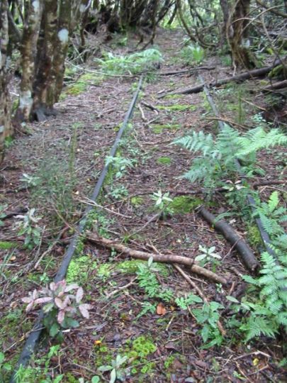
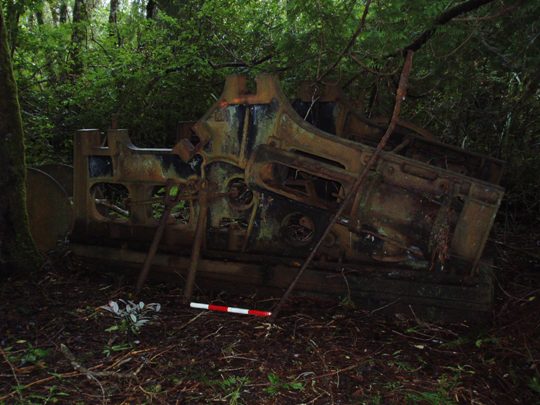
Mill Site The first evidence of the Makatote Tramway is the mill site, which is accessed via an unmarked track that crosses the road reserve into the Tongariro National Park. The mill site is in a relatively flat, open area and although there is no structural evidence of the mill, there are artefactual remains, most notably a metal plate (possible boiler plate) and various domestic items such as billies and pails. The size and structure of the mill is unclear, but its position is verified by historical maps/plans. Tramway The Makatote Tramway site consists of a branching network of tramlines that head in an easterly/north-easterly direction across the relatively flat land to the east of State Highway 4. These tramlines and their associated features such as skid sites and draglines were constructed as a result of milling operations by the Karioi Sawmilling Company (1929-1931) and Dinwoodie Timber Company (1934-1939). There are both wooden and metal rails, as well as a corduroy track in the northwest of the site. Whilst no conclusive comments can be drawn about the sequence of construction, historical documents indicate that the "the whole of the left hand branch and part of the right hand branch towards the eastern extremity" were constructed by the Dinwoodie Timber Company. Main branch: The tramway begins from the mill site and continues in a northeasterly direction. Few sleepers and rails are remaining, but the formation is clearly visible. A bogey wheel was also observed on the main branch, shortly before a junction where it splits into two (hereafter referred to as the 'left-hand branch' and 'right-hand' branch'.) Left-hand branch (LHB): The LHB runs in a northerly direction from the main branch junction and it has several side branches to the east and west. The second side branch to the west of the LHB is notable for its in situ rails, bearers and sleepers, and it also has a points change. It leads to a skid site and log hauler, which is imprinted with the name 'S. Luke and Co Ltd, Wellington' - one of the 13 principal log hauler manufacturers in New Zealand. The log hauler has a noticeable crack in the side, and is likely to have been abandoned here as a result. The LHB then continues past the side branches for a distance before splitting into two at the former boundary between Lots 10 and 11. The left left-hand branch (LLHB) has more in situ sleepers, rails and bearers than the LHB, and there are numerous water pits along both sides of the tramway. These pits are of varying shapes and sizes, including one with clearly excavated sites measuring 2m x 1.5m, with a depth of 2.3m. The LLHB also has two skid sites, a causeway and a bridge crossing. The right left-hand branch (RLHB) of the tramway runs in an easterly direction from the junction, and is a very different formation from the LLHB with its in situ lengths of wooden tramway. The RLHB has two bridge crossings and largely consists of intermittent sections of corduroys, though there is a small length of wooden tramway at the very end of the branch, which was discovered after cutting through an area of fairly dense natives. This wooden tramway leads to a skid site and associated draglines. There is also a junction partway along the RLHB, at which point you can either continue straight ahead, or loop back along a corduroy track towards the LLHB. Corduroy track: A corduroy track begins at the junction on the LRHB and continues in a northwesterly direction as far as the western edge of former Lot 11 (see Figure 5, Appendix 4). There are two distinct draglines off this track to the northeast, and both run down to the Makomiko Stream. The southernmost dragline has a bridge across the Makomiko Stream and continues on the other side, but there was no clear crossing for the dragline at the northwestern end of the corduroy track. The latter dragline was of particular note as parallel logs had been placed on the upward slope to assist with the hauling of logs. A large skid site was located and recorded to the northwest of the corduroy track, almost at the western edge of former Lot 11. The exact age and function of this corduroy track is unclear, but Dinwoodie possibly used this track for hauling logs with his R D 6 Caterpillar. Right hand branch (RHB): The RHB heads east up a slight incline with exotics planted on either side of the formation, and then continues in a north-easterly direction towards the edge of former Lot 10, where a skid site and associated drag lines were recorded. Historic maps indicate that it continued beyond this point into the block of Lawson's Cypress, and although draglines are visible in this area on aerial photographs, these were not located during the archaeological survey. The RHB is overgrown in places, but continuous lengths of wooden rail, including a section of double tramline, are present, and there are metal rails further along the branch. There are also a number of bridge crossings along the RHB and several side branches with skid sites and draglines, including two to the south which cross the stream. Recorded artefacts along the RHB (and its side branches) including numerous bogey wheels. Skid Sites and Drag Lines 16 skid sites have been recorded within the Makatote Tramway site, either adjacent to the main branches or at the end of side branches. These skid sites are of varying condition and size, but they all have the same basic construction whereby a series of base lateral logs supported several cross beams, which the logs were hauled onto. The lateral logs were notched to support the cross beams. Wire rope was frequently observed around tree trunks in close proximity to the skid sites, and scaffolding marks were also recorded on two tree trunks. Associated draglines also varied in their length and depth; some were difficult to detect whilst others were clearly visible with a depth of 1 to 1.5 metres. In some cases, the drag lines also forked, as seen with the drag line that runs off the corduroy track down to the Makomiko Stream and continues on the other side. This drag line is 2 metres wide, 0.6m metres deep and has a length of 243.5 metres before it forks into two branches. The left hand branch continues for another 49 metres whilst the right hand branch continues for a further 229 metres. House Sites There are no structural remains of any houses associated with the Makatote Tramway and mill, but oral history interviews indicate that there were 3 houses, located in the clearings along the eastern side of State Highway 4 (between the road and the National Park). These clearings were inspected as part of the archaeological survey of the site, and relevant features were recorded. A pit was noted in the northern most clearing (House Site 1) and various artefacts were observed including a white china plate with the inscription 'Victoria/China/Czechoslovakia'. The next clearing to the south (House Site 2) contained a number of pit features, and further pits were recorded in the bush to the north of this clearing, as were artefacts such as ceramics, bottle glass and an enamel billy. Two in situ wooden posts and a metal pipe were also recorded in this clearing. Two pits and a wooden post were recorded in the third clearing (House Site 3) heading south towards the Makatote Gully, and a fourth, much larger clearing (House Site 4) contained a pit filled with twentieth century European artefacts, including broken ceramics and glass.
Mill Site The first evidence of the Makatote Tramway is the mill site, which is accessed via an unmarked track that crosses the road reserve into the Tongariro National Park. The mill site is in a relatively flat, open area and although there is no structural evidence of the mill, there are artefactual remains, most notably a metal plate (possible boiler plate) and various domestic items such as billies and pails. The size and structure of the mill is unclear, but its position is verified by historical maps/plans. Tramway The Makatote Tramway site consists of a branching network of tramlines that head in an easterly/north-easterly direction across the relatively flat land to the east of State Highway 4. These tramlines and their associated features such as skid sites and draglines were constructed as a result of milling operations by the Karioi Sawmilling Company (1929-1931) and Dinwoodie Timber Company (1934-1939). There are both wooden and metal rails, as well as a corduroy track in the northwest of the site. Whilst no conclusive comments can be drawn about the sequence of construction, historical documents indicate that the "the whole of the left hand branch and part of the right hand branch towards the eastern extremity" were constructed by the Dinwoodie Timber Company. Main branch: The tramway begins from the mill site and continues in a northeasterly direction. Few sleepers and rails are remaining, but the formation is clearly visible. A bogey wheel was also observed on the main branch, shortly before a junction where it splits into two (hereafter referred to as the 'left-hand branch' and 'right-hand' branch'.) Left-hand branch (LHB): The LHB runs in a northerly direction from the main branch junction and it has several side branches to the east and west. The second side branch to the west of the LHB is notable for its in situ rails, bearers and sleepers, and it also has a points change. It leads to a skid site and log hauler, which is imprinted with the name 'S. Luke and Co Ltd, Wellington' - one of the 13 principal log hauler manufacturers in New Zealand. The log hauler has a noticeable crack in the side, and is likely to have been abandoned here as a result. The LHB then continues past the side branches for a distance before splitting into two at the former boundary between Lots 10 and 11. The left left-hand branch (LLHB) has more in situ sleepers, rails and bearers than the LHB, and there are numerous water pits along both sides of the tramway. These pits are of varying shapes and sizes, including one with clearly excavated sites measuring 2m x 1.5m, with a depth of 2.3m. The LLHB also has two skid sites, a causeway and a bridge crossing. The right left-hand branch (RLHB) of the tramway runs in an easterly direction from the junction, and is a very different formation from the LLHB with its in situ lengths of wooden tramway. The RLHB has two bridge crossings and largely consists of intermittent sections of corduroys, though there is a small length of wooden tramway at the very end of the branch, which was discovered after cutting through an area of fairly dense natives. This wooden tramway leads to a skid site and associated draglines. There is also a junction partway along the RLHB, at which point you can either continue straight ahead, or loop back along a corduroy track towards the LLHB. Corduroy track: A corduroy track begins at the junction on the LRHB and continues in a northwesterly direction as far as the western edge of former Lot 11 (see Figure 5, Appendix 4). There are two distinct draglines off this track to the northeast, and both run down to the Makomiko Stream. The southernmost dragline has a bridge across the Makomiko Stream and continues on the other side, but there was no clear crossing for the dragline at the northwestern end of the corduroy track. The latter dragline was of particular note as parallel logs had been placed on the upward slope to assist with the hauling of logs. A large skid site was located and recorded to the northwest of the corduroy track, almost at the western edge of former Lot 11. The exact age and function of this corduroy track is unclear, but Dinwoodie possibly used this track for hauling logs with his R D 6 Caterpillar. Right hand branch (RHB): The RHB heads east up a slight incline with exotics planted on either side of the formation, and then continues in a north-easterly direction towards the edge of former Lot 10, where a skid site and associated drag lines were recorded. Historic maps indicate that it continued beyond this point into the block of Lawson's Cypress, and although draglines are visible in this area on aerial photographs, these were not located during the archaeological survey. The RHB is overgrown in places, but continuous lengths of wooden rail, including a section of double tramline, are present, and there are metal rails further along the branch. There are also a number of bridge crossings along the RHB and several side branches with skid sites and draglines, including two to the south which cross the stream. Recorded artefacts along the RHB (and its side branches) including numerous bogey wheels. Skid Sites and Drag Lines 16 skid sites have been recorded within the Makatote Tramway site, either adjacent to the main branches or at the end of side branches. These skid sites are of varying condition and size, but they all have the same basic construction whereby a series of base lateral logs supported several cross beams, which the logs were hauled onto. The lateral logs were notched to support the cross beams. Wire rope was frequently observed around tree trunks in close proximity to the skid sites, and scaffolding marks were also recorded on two tree trunks. Associated draglines also varied in their length and depth; some were difficult to detect whilst others were clearly visible with a depth of 1 to 1.5 metres. In some cases, the drag lines also forked, as seen with the drag line that runs off the corduroy track down to the Makomiko Stream and continues on the other side. This drag line is 2 metres wide, 0.6m metres deep and has a length of 243.5 metres before it forks into two branches. The left hand branch continues for another 49 metres whilst the right hand branch continues for a further 229 metres. House Sites There are no structural remains of any houses associated with the Makatote Tramway and mill, but oral history interviews indicate that there were 3 houses, located in the clearings along the eastern side of State Highway 4 (between the road and the National Park). These clearings were inspected as part of the archaeological survey of the site, and relevant features were recorded. A pit was noted in the northern most clearing (House Site 1) and various artefacts were observed including a white china plate with the inscription 'Victoria/China/Czechoslovakia'. The next clearing to the south (House Site 2) contained a number of pit features, and further pits were recorded in the bush to the north of this clearing, as were artefacts such as ceramics, bottle glass and an enamel billy. Two in situ wooden posts and a metal pipe were also recorded in this clearing. Two pits and a wooden post were recorded in the third clearing (House Site 3) heading south towards the Makatote Gully, and a fourth, much larger clearing (House Site 4) contained a pit filled with twentieth century European artefacts, including broken ceramics and glass.
Historical and Associated Iwi / Hapū / Whānau
Public NZAA Number
S20/32
Completion Date
1st March 2006
Report Written By
Lyn Williams, Kathryn Mercer with Jo Wylie
Information Sources
Allen, 1984
Elizabeth Allen, In the Hills of the Waimarino: the Human Story of the Development of the District, Wanganui: Wanganui Newspapers Ltd, 1984.
Archives New Zealand (Wgtn)
Archives New Zealand (Wellington)
George, 1990
Merrilyn George, Ohakune: Opening to a New World, Ohakune: Kapai Enterprises, 1990.
Mahoney, 1998
Paul Mahoney, The Era of the Bush Tram in New Zealand, Wellington: IPL Books, 1998.
Watson, 2005
Katharine Watson, 'Makatote Tramway: An Archaeological Assessment', Unpublished Report for the New Zealand Historic Places Trust, 2005.
Other Information
Gazetted as an Archaeological Site under the HPA. Please note that entry on the New Zealand Heritage List/Rarangi Korero identifies only the heritage values of the property concerned, and should not be construed as advice on the state of the property, or as a comment of its soundness or safety, including in regard to earthquake risk, safety in the event of fire, or insanitary conditions.
Current Usages
Uses: Civic Facilities
Specific Usage: National park
Former Usages
General Usage: Forestry
Specific Usage: Forestry/mill camp/settlement/housing
Current Usages
Uses: Civic Facilities
Specific Usage: National park
Former Usages
General Usage: Forestry
Specific Usage: Forestry/mill camp/settlement/housing
Location
Sign up to hear more
Get the latest heritage news, features and events delivered
straight to your inbox.
