

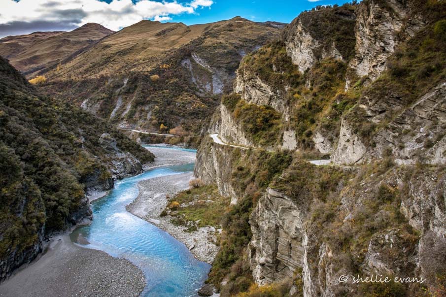
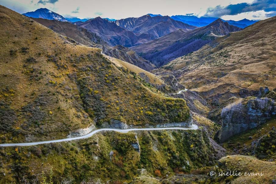
Built in four stages from 1883 to 1890, and only a single lane wide, its construction had to overcome major physical obstacles before it could be completed. The most spectacular of these (Pinchers Bluff) required the removal of large amounts of rock to create a road platform. The road and the country it travels through are both spectacular and scenic. The road is most significant too as, in all likelihood, the only nineteenth century road that has remained in continuous use without major upgrading.
The road was built to improve access to the upper Shotover River for miners, particularly for those seeking to install large machinery. It also provided a better means of access for those living in the canyon than the existing packtrack (1863). Mining's heyday was over by the time the road was completed but it continued to be used by farmers and tourists and those mining operations that lingered on in the twentieth century.
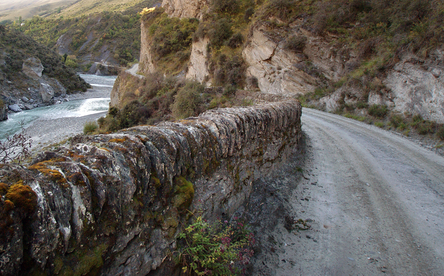
Although much of the road remains as it did in the nineteenth century, the topography, harsh climate, widening, and regular maintenance have led to the loss of some significant features, including some of its stone walls, famous features intended to prevent vehicles from toppling off the road. Today tourism is the road's biggest user, with many people coming to see the road or use it as a means of access to bungy jumping operations or white water rafting. Skippers Road is an iconic New Zealand road of outstanding heritage significance.
List Entry Information
Status
Listed
List Entry Status
Historic Place Category 1
Access
Able to Visit
List Number
7684
Date Entered
15th December 2006
Date of Effect
15th December 2006
City/District Council
Queenstown-Lakes District
Region
Otago Region
Extent of List Entry
Registration includes the length of Skippers Road from Skippers Saddle (several hundred metres after the intersection with Coronet Peak Road) and the nominated conclusion of the road (Skippers Cemetery), a distance of 16.5 kilometres. The breadth of the registered item is the legal road - being 20 metres wide - although practicalities make this untenable where the road is very close to the river or on particularly steep hillsides. The registration includes the bridges, stone walls, revetments, road formation and associated features. This registration does not extend to what was once the full length of the road - from Arthurs Point to Skippers. The road between Arthurs Point (some regard the starting point as Queenstown) and Skippers Saddle is now under seal and much altered in many other ways. Also not included is the small section of unsealed road, now considerably widened, from the intersection of the Skippers Road and Coronet Peak Road.
Legal description
Road Reserve, Otago Land District
Location Description
Skippers Road runs from Arthurs Point (about 3 miles north of Queenstown) to Skippers Point however, only part of the road is included in the registration (Skippers Saddle to Skippers Cemetery).
Why is this place significant?
Cultural Significance
Skippers Road is a place that has special cultural and social significance. It is internationally recognised for its qualities, having featured in overseas publications both on roads and New Zealand tourism. It is well known as a destination for tourists - local or overseas - and is held in great affection by locals and outsiders alike for its unique character. The road is carved in New Zealand lore for its role in mining, farming and tourism heritage. It has been the subject of books, chapters in books, and is referenced in a variety of publications of various kinds (see Sources). There can be few roads in New Zealand that have mustered the level of public recognition that Skippers Road has.
Historic Significance
Historical Significance or Value Skippers Road is of special historical significance for the century and more that it has been the primary access to the remote gold mining and farming region and tourist destination at the upper reaches of the Shotover River. The road was completed in 1890 and it has carried hundreds of thousands of vehicles and horse drawn traffic along a narrow and at times awkward road. The road was built as a response to demand by gold miners on the Shotover River and it has been in continual use. The road was of great importance to the gold mining industry. Prior to the construction of the road, the movement of goods and people was via a packtrack constructed in 1863, entirely unsuited to the movement of large and awkward goods. It was the demand for a proper road to move machinery of a substantial size that partly prompted the construction of the road. Just as importantly, it gave road access to the people living in the upper Shotover, who numbered in the hundreds and relied on a difficult packtrack for access to the outside world. The road allowed the gold mining industry to move materials and supplies in a much more efficient fashion and it helped with the expansion of operations from small claims to larger scale extraction. Even after the demise of gold mining, farming and tourist traffic kept the road in regular use, although the former has waned in importance throughout the twentieth century. Tourist traffic has been a significant user of the road since it was constructed and, 116 years since it opened, it can be considered one of the most enduring tourist attractions in New Zealand history. Many tourists visit just to experience the road, a remarkable testimony to its attractions. Tourist traffic is also generated by other outdoor activities on the road and this is unlikely to diminish in the coming decades.
Physical Significance
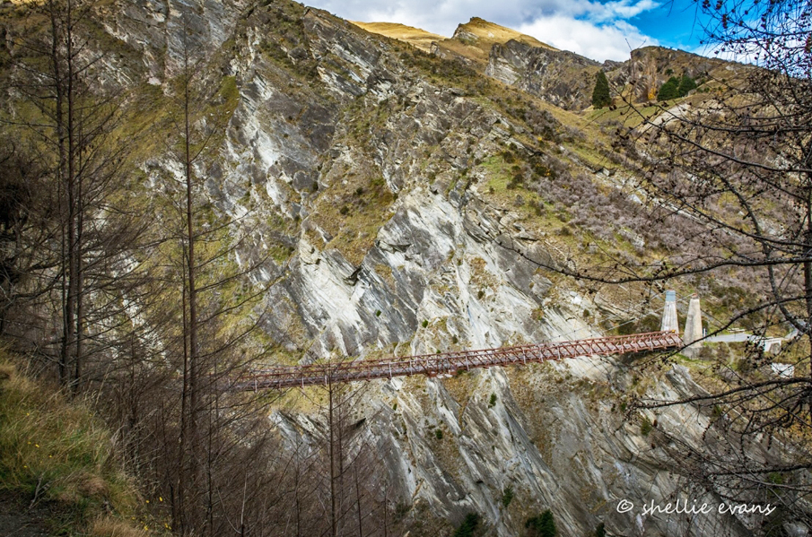
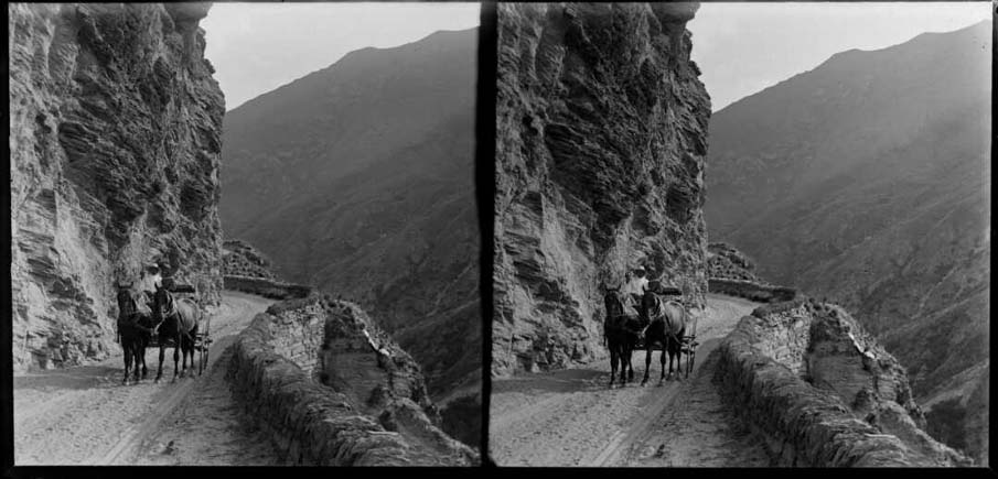
Skippers Road is a place of the outstanding archaeological, technological and aesthetic significance. The road retains significant archaeological values, despite the changes to it over its history. Those archaeological values are both below and above the ground. The former include the road's subsurface structure, features and fragments possibly now buried or partly destroyed such as stone culverts and drains, or associated features relating to the road and its past uses (buildings sites, walls, machinery etc.) that are now no longer visible. Those archaeological features still visible include the stone walls and revetting, evidence of hand working on rock walls, original or early bench cuts, culverts and drains, and other road features not mentioned above that were part of the original road. From a technological perspective, the road is of outstanding significance. It is first and foremost a remarkable structural feat. The road was built in steep and difficult country, largely as bench cuts on the side of mountains, by men using pick and shovel, augmented by explosives. Some of the sections are truly extraordinary, particularly those that required constructing the road through sheer rock, including Hells Gate and Heavens Gate (on the Skippers Saddle to Long Gully section) and Pinchers Bluff / Devils Elbow. The latter involved the removal of an entire portion of the rock wall overhanging the river to create a rock platform wide enough for vehicles. There was no other way of providing vehicular access to the Skippers area without it. It is the most spectacular and best known of a host of remarkable road building features. The road is also celebrated for its magnificent setting and the role it plays in that setting. The road is narrow and metalled and, in most places, has had a modest impact on the landscape, while adding a singular feature of great cultural significance to it. However, it should also be acknowledged that, in some places, slips and slumps and poor water management have had an unfavourable impact on the landscape.The road is also, relatively, unchanged from the time of its construction, with the exception of the losses outlined in the section above. The road's significance is not badly diminished for that fact, in that many of the physical features that have marked the road for 116 years remain, and the only constant change has been the road surface and some associated features. Also of outstanding technological significance is the Skippers Suspension Bridge. At over 91 metres above the river, it is New Zealand's highest suspension bridge. It is sited in a challenging environment; with its builders having to deal with extremes in climate, the forbidding landscape in the spectacular Skippers Canyon, and traversing the equally outstanding Skippers Road.
Why is this place Category 1 / Category 2?
Detail Of Assessed Criteria
(a) The extent to which the place reflects important or representative aspects of New Zealand history Skippers Road reflects both important and representative aspects of this country's history. Its association with gold mining, one of the key drivers of the economy of nineteenth century New Zealand, is most significant, even though the road was built long after its heyday. The Shotover River was one of the richest of all gold-bearing New Zealand rivers and the construction of the road was partly a response to expectations that larger extraction methods would continue to draw large amounts of gold out of the river. Although that never really transpired, gold mining continued to play a role in Skippers Canyon until the 1970s. The road was also a lifeline for farming communities. Although the road was not always open, it offered general surety of access and allowed significant high country stations to function far more effectively than if a packtrack had been the only means of travel. Tourism has been a most significant and lingering feature of the road. It began soon after the road was completed and, as it has always been one of the road's uses (except when it was closed for snow and ice), Skippers Road can be regarded as one of the country's most successful tourist destinations - certainly in terms of its longevity. (b) The association of the place with events, persons, or ideas of importance in New Zealand history The road is peripherally associated with the on going gold mining industry in the Shotover Valley and has an association with the gold rush period in this region. It was built for mining purposes 20 years after the initial rush, but provided a vital physical link with the outside world for the miners in the Valley. (c) The potential of the place to provide knowledge of New Zealand history There is much historical and physical evidence that the road and its immediate environs offer the potential to reveal important information through archaeological methods. Apart from the construction, modification and 115 years of use of the road itself, there are numerous places immediately alongside where human use and occupation has taken place. (e) The community association with, or public esteem for, the place There are a number of New Zealand roads that might be regarded affectionately by its users but it is likely that no road in this country is regarded as fondly by those who have travelled it as Skipper Canyon Road. This is all the more surprising given its challenges but, perhaps because of those very hazards, the road seems to elicit unusually warm and nostalgic feelings. The local community - those who live on the road and in the wider Queenstown-Lakes area - is very proud of the road and is anxious to secure its future, as indicated by the Branch Committee's prioritisation of the road as an anniversary registration project. Four books have been written by local historians on Skippers Road illustrating the importance of the road locally. In addition tourists, both from New Zealand and international travellers, respond to the road's appeal by driving it in their thousands and, while some find it uncomfortably dangerous, most (judging by comments posted on the internet) find it exhilarating and beguiling. (f) The potential of the place for public education The road and its environs have enormous potential for public education. This is already realised to some extent by the road's very characteristics, which can tell the viewer much about the road's construction and past uses. There is some interpretation offered at present, including guided tours, and school groups visit the restored buildings at the site of Mt Aurum homestead, but much more can be done to unlock the road's potential. (g) The technical accomplishment or value, or design of the place The road is a simple, one-lane unsealed road, yet it demonstrates a remarkable level of technical accomplishment, the major achievements being: the overcoming of major physical obstacles (e.g. Pinchers Bluff) in the course of construction; its conquering of a challenging environment both physically and climatically; and its construction using nineteenth century tools and technology. Specific sections of the road are outstandingly significant in their technical accomplishment. Among them are Hells Gate and Heavens Gate, Pinchers Bluff and the Devils Elbow - as well as other surviving sections containing revetting and stone walling. As noted above, the Skippers Suspension Bridge is also outstanding in its design. (j) The importance of identifying rare types of historic places There are relatively few nineteenth century roads in New Zealand that are in substantially original condition and Skippers Road is the only one known to still be in regular vehicular use. At present three roads have been registered by the Historic Places Trust, two of which were constructed in the nineteenth century. There are other nineteenth century roads (and fragments of roads) that remain intact but are not recognised on heritage inventories e.g. portions of the Arthurs Pass Road. Most of these roads are used for a variety of purposes, but none is open to vehicular use by the public. Almost any road that remains in active use undergoes modifications and improvements to make them meet modern expectations. Skippers Road is therefore unique as a road that has remained in use in largely its original state. In addition, particular features of the road, such as Pinchers Bluff, may be rare, if not unique in New Zealand roading. More work may be needed to establish this for certain, but no other example of a road constructed in New Zealand out of a sheer rock face is has been identified at the time of nomination (2006). (k) The extent to which the place forms part of a wider historical and cultural complex or historical and cultural landscape Skippers Road is part of a large and important heritage landscape covering its geological formation and 140 years of continuous human occupation. During the gradual formation of the landscape, gold reefs were laid. These were then partly eroded by glaciation or rivers and the gold settled into stream beds. The attraction of the gold brought many people to the region. As a result, gold mining, and later farming and tourism have all left their mark on the landscape, with mining in particular having altered the environment dramatically. Whole terraces have been sluiced away while the remnants of past activities found throughout the Shotover River. The area also contains historic buildings and ruins, packtracks, bridges, mining relics and archaeological remains of various kinds. Summary of Significance Skippers Road is worthy of Category I registration because it is an outstanding example of a nineteenth century road which shows tremendous technical accomplishment in its construction in the spectacular and forbidding Skippers Canyon, and is a rare example of such a road that is still in use in 2006. In its setting it is a special part of a wider Skippers heritage landscape, and is much valued by the its community of users.
Why is this place significant?
Cultural Significance
Skippers Road is a place that has special cultural and social significance. It is internationally recognised for its qualities, having featured in overseas publications both on roads and New Zealand tourism. It is well known as a destination for tourists - local or overseas - and is held in great affection by locals and outsiders alike for its unique character. The road is carved in New Zealand lore for its role in mining, farming and tourism heritage. It has been the subject of books, chapters in books, and is referenced in a variety of publications of various kinds (see Sources). There can be few roads in New Zealand that have mustered the level of public recognition that Skippers Road has.
Historic Significance
Historical Significance or Value Skippers Road is of special historical significance for the century and more that it has been the primary access to the remote gold mining and farming region and tourist destination at the upper reaches of the Shotover River. The road was completed in 1890 and it has carried hundreds of thousands of vehicles and horse drawn traffic along a narrow and at times awkward road. The road was built as a response to demand by gold miners on the Shotover River and it has been in continual use. The road was of great importance to the gold mining industry. Prior to the construction of the road, the movement of goods and people was via a packtrack constructed in 1863, entirely unsuited to the movement of large and awkward goods. It was the demand for a proper road to move machinery of a substantial size that partly prompted the construction of the road. Just as importantly, it gave road access to the people living in the upper Shotover, who numbered in the hundreds and relied on a difficult packtrack for access to the outside world. The road allowed the gold mining industry to move materials and supplies in a much more efficient fashion and it helped with the expansion of operations from small claims to larger scale extraction. Even after the demise of gold mining, farming and tourist traffic kept the road in regular use, although the former has waned in importance throughout the twentieth century. Tourist traffic has been a significant user of the road since it was constructed and, 116 years since it opened, it can be considered one of the most enduring tourist attractions in New Zealand history. Many tourists visit just to experience the road, a remarkable testimony to its attractions. Tourist traffic is also generated by other outdoor activities on the road and this is unlikely to diminish in the coming decades.
Physical Significance
Skippers Road is a place of the outstanding archaeological, technological and aesthetic significance. The road retains significant archaeological values, despite the changes to it over its history. Those archaeological values are both below and above the ground. The former include the road's subsurface structure, features and fragments possibly now buried or partly destroyed such as stone culverts and drains, or associated features relating to the road and its past uses (buildings sites, walls, machinery etc.) that are now no longer visible. Those archaeological features still visible include the stone walls and revetting, evidence of hand working on rock walls, original or early bench cuts, culverts and drains, and other road features not mentioned above that were part of the original road. From a technological perspective, the road is of outstanding significance. It is first and foremost a remarkable structural feat. The road was built in steep and difficult country, largely as bench cuts on the side of mountains, by men using pick and shovel, augmented by explosives. Some of the sections are truly extraordinary, particularly those that required constructing the road through sheer rock, including Hells Gate and Heavens Gate (on the Skippers Saddle to Long Gully section) and Pinchers Bluff / Devils Elbow. The latter involved the removal of an entire portion of the rock wall overhanging the river to create a rock platform wide enough for vehicles. There was no other way of providing vehicular access to the Skippers area without it. It is the most spectacular and best known of a host of remarkable road building features. The road is also celebrated for its magnificent setting and the role it plays in that setting. The road is narrow and metalled and, in most places, has had a modest impact on the landscape, while adding a singular feature of great cultural significance to it. However, it should also be acknowledged that, in some places, slips and slumps and poor water management have had an unfavourable impact on the landscape.The road is also, relatively, unchanged from the time of its construction, with the exception of the losses outlined in the section above. The road's significance is not badly diminished for that fact, in that many of the physical features that have marked the road for 116 years remain, and the only constant change has been the road surface and some associated features. Also of outstanding technological significance is the Skippers Suspension Bridge. At over 91 metres above the river, it is New Zealand's highest suspension bridge. It is sited in a challenging environment; with its builders having to deal with extremes in climate, the forbidding landscape in the spectacular Skippers Canyon, and traversing the equally outstanding Skippers Road.
Why is this place Category 1 / Category 2?
Detail Of Assessed Criteria
(a) The extent to which the place reflects important or representative aspects of New Zealand history Skippers Road reflects both important and representative aspects of this country's history. Its association with gold mining, one of the key drivers of the economy of nineteenth century New Zealand, is most significant, even though the road was built long after its heyday. The Shotover River was one of the richest of all gold-bearing New Zealand rivers and the construction of the road was partly a response to expectations that larger extraction methods would continue to draw large amounts of gold out of the river. Although that never really transpired, gold mining continued to play a role in Skippers Canyon until the 1970s. The road was also a lifeline for farming communities. Although the road was not always open, it offered general surety of access and allowed significant high country stations to function far more effectively than if a packtrack had been the only means of travel. Tourism has been a most significant and lingering feature of the road. It began soon after the road was completed and, as it has always been one of the road's uses (except when it was closed for snow and ice), Skippers Road can be regarded as one of the country's most successful tourist destinations - certainly in terms of its longevity. (b) The association of the place with events, persons, or ideas of importance in New Zealand history The road is peripherally associated with the on going gold mining industry in the Shotover Valley and has an association with the gold rush period in this region. It was built for mining purposes 20 years after the initial rush, but provided a vital physical link with the outside world for the miners in the Valley. (c) The potential of the place to provide knowledge of New Zealand history There is much historical and physical evidence that the road and its immediate environs offer the potential to reveal important information through archaeological methods. Apart from the construction, modification and 115 years of use of the road itself, there are numerous places immediately alongside where human use and occupation has taken place. (e) The community association with, or public esteem for, the place There are a number of New Zealand roads that might be regarded affectionately by its users but it is likely that no road in this country is regarded as fondly by those who have travelled it as Skipper Canyon Road. This is all the more surprising given its challenges but, perhaps because of those very hazards, the road seems to elicit unusually warm and nostalgic feelings. The local community - those who live on the road and in the wider Queenstown-Lakes area - is very proud of the road and is anxious to secure its future, as indicated by the Branch Committee's prioritisation of the road as an anniversary registration project. Four books have been written by local historians on Skippers Road illustrating the importance of the road locally. In addition tourists, both from New Zealand and international travellers, respond to the road's appeal by driving it in their thousands and, while some find it uncomfortably dangerous, most (judging by comments posted on the internet) find it exhilarating and beguiling. (f) The potential of the place for public education The road and its environs have enormous potential for public education. This is already realised to some extent by the road's very characteristics, which can tell the viewer much about the road's construction and past uses. There is some interpretation offered at present, including guided tours, and school groups visit the restored buildings at the site of Mt Aurum homestead, but much more can be done to unlock the road's potential. (g) The technical accomplishment or value, or design of the place The road is a simple, one-lane unsealed road, yet it demonstrates a remarkable level of technical accomplishment, the major achievements being: the overcoming of major physical obstacles (e.g. Pinchers Bluff) in the course of construction; its conquering of a challenging environment both physically and climatically; and its construction using nineteenth century tools and technology. Specific sections of the road are outstandingly significant in their technical accomplishment. Among them are Hells Gate and Heavens Gate, Pinchers Bluff and the Devils Elbow - as well as other surviving sections containing revetting and stone walling. As noted above, the Skippers Suspension Bridge is also outstanding in its design. (j) The importance of identifying rare types of historic places There are relatively few nineteenth century roads in New Zealand that are in substantially original condition and Skippers Road is the only one known to still be in regular vehicular use. At present three roads have been registered by the Historic Places Trust, two of which were constructed in the nineteenth century. There are other nineteenth century roads (and fragments of roads) that remain intact but are not recognised on heritage inventories e.g. portions of the Arthurs Pass Road. Most of these roads are used for a variety of purposes, but none is open to vehicular use by the public. Almost any road that remains in active use undergoes modifications and improvements to make them meet modern expectations. Skippers Road is therefore unique as a road that has remained in use in largely its original state. In addition, particular features of the road, such as Pinchers Bluff, may be rare, if not unique in New Zealand roading. More work may be needed to establish this for certain, but no other example of a road constructed in New Zealand out of a sheer rock face is has been identified at the time of nomination (2006). (k) The extent to which the place forms part of a wider historical and cultural complex or historical and cultural landscape Skippers Road is part of a large and important heritage landscape covering its geological formation and 140 years of continuous human occupation. During the gradual formation of the landscape, gold reefs were laid. These were then partly eroded by glaciation or rivers and the gold settled into stream beds. The attraction of the gold brought many people to the region. As a result, gold mining, and later farming and tourism have all left their mark on the landscape, with mining in particular having altered the environment dramatically. Whole terraces have been sluiced away while the remnants of past activities found throughout the Shotover River. The area also contains historic buildings and ruins, packtracks, bridges, mining relics and archaeological remains of various kinds. Summary of Significance Skippers Road is worthy of Category I registration because it is an outstanding example of a nineteenth century road which shows tremendous technical accomplishment in its construction in the spectacular and forbidding Skippers Canyon, and is a rare example of such a road that is still in use in 2006. In its setting it is a special part of a wider Skippers heritage landscape, and is much valued by the its community of users.
Construction Professional
Name
A.J. Fraser and Company
Type
Builder
Biography
A.J. Fraser and Company of Naseby
Name
Black, John
Type
Engineer
Biography
John Black was engineer to the Lakes County Council from March 1886 to July 1903. He had earlier worked with the Public Works Department. After he left Lakes County Council he working briefly for Ohinemuri County Council before working on drainage work on the Hauraki Plains for the Department of Lands and Survey.
Name
Mollinson, James
Type
Engineer
Biography
No biography is currently available for this construction professional
Construction Details
Start Year
1961
Type
Modification
Description
Replacement of Long Gully Bridge
Start Year
1883
Type
Designed
Start Year
1883
Finish Year
1890
Type
Original Construction
Start Year
1901
Type
Modification
Description
Replacement of bridge at Londonderry Creek with Skippers Bridge. New road constructed from old turn-off to bridge and from there to Skippers township.
Start Year
1954
Type
Modification
Description
Replacement of Deep Creek Bridge
Construction Materials
Pavement: Metal (gravel and rock - renewed at intervals) Formation: Not known but presumed to be layers of coarse rock and finer material. Outside walls (some): Schist Revetting: Schist Culverts: Schist (now also concrete, aluminium or plastic)
Notable Features
Skippers Suspension Bridge Bells Bridge (Long Gully) Deep Creek Bridge Various tors (rock outcrops) and bluffs Pinchers Bluff road formation Stone revetting (various) Stone walls (various)
Introduction Skippers Road was completed in 1890 to provide access to the goldfields of the upper Shotover River. It has its origins on the Central Otago gold rush of the early 1860s; it replaced an earlier packtrack (1863) which was the only access for over 20 years. Single lane and never upgraded, the road has been in continuous use (with the exception of closures for snow or slips) and is in 2006 a major tourist attraction. Gold in the Shotover Valley The discovery of gold in Central Otago, at Gabriel's Gully on 23 May 1861, was the catalyst for New Zealand's first gold rush. Alert to the potential of the region, prospectors arrived by the thousands from within New Zealand and further afield, while many existing settlers turned their hand to prospecting. By 1862, other parts of accessible Central Otago had been explored and some isolated places had been settled. The town of Queenstown, on the banks of Lake Wakatipu, had been founded, although it was very much in its infancy. The Shotover River, which flowed into the the Kawarau River downstream of the outlet to Lake Wakatipu, near present day Frankton, was the scene that year of the event that ultimately led to the construction of Skippers Road. Thomas Arthur and Harry Redfern were two destitute individuals, 'dead broke and dressed in rags' , who were hired to shear the sheep of local pastoral lessee William Rees. On a day off they went prospecting a short distance up the Shotover River and found 113 grams of gold in one afternoon. They left their new jobs, recovered 5.6 kilograms of gold over the following week and had made their fortunes. Altruistically, they made no attempt to hide their discovery and, within weeks, the Shotover Valley was full of people trying their luck - some 1000 individuals by the end of the year. Thomas Arthur left his mark on the landscape in another way; Arthur's Point, near the Edith Cavell Bridge, was named after him. Many people made fortunes in the Shotover, with easy pickings on offer for the early arrivals. Thousands of men flocked to the river to try their luck and conditions were very difficult for most. Perhaps the biggest impediment to prospectors servicing their claim was access into the valley, which was difficult at the best of times. Some tried to work their way up the riverbed itself, a hugely risky business, especially in winter, and more than one person died attempting it. Some made their way up the valley and lowered themselves down to likely looking beaches by ropes. The canyon was aptly named, so miners primarily opted for overland routes, and various tracks were quickly worn into the mountain sides by prospectors humping supplies or by men working for entrepreneurial merchants and hoteliers. Two of the most profitable stretches were at Maori Point (named after two Maori miners, Rangiora Ellison and Hakaria Haeroa who discovered gold there in 1862) and Skippers Point, and substantial populations soon clustered around those two places. By mid-1863, the population in the Shotover was officially estimated at 4116 , and the pressure for formed access was overwhelming. A public meeting was called in May 1863 to push for the construction of a road. The Lake Wakatip Mail's Shotover correspondent reported the following week that the provincial government had erected guide posts to mark the various trails to the gorge for the coming winter. Life for the packers who worked the trails was dangerous, and the maximum working life for a packer's horse on the trail was 3 months. The First Formed Access The provincial government stepped into the matter and in June 1863 commissioned a packtrack. There was no shortage of tenderers, nor was there a lack of willing workers, many of whom were drawn from the ranks of those facing hard times after unsuccessful stints as prospectors. A line was surveyed from the bottom of Coronet Peak and closely followed the main route already used by packers. The contract for the track was let in July 1863 to a Mr Armstrong. Work was completed the following year but the formed track ended at Maori Point. W.C. Wright, the Mining Surveyor, in advocating for the completion of the track as far as Skippers, wrote that the 'great drawback to the prosecution of quartz mining is the want of roads. The present [temporary] track between Maori Point and the Reefs is dangerous in the extreme, and accidents are of daily occurrence. The effect of the want of roads upon the price of provisions and produce is perhaps the most serious drawback of any.' The track was finally completed (as far as Skippers) in 1866, and during this time, one portion (from Long Gully to Green Gate Saddle) was rebuilt after the original route was considered to be too steep. The track, which was approximately 1.8 metres uniform width over its length, included a tortuous zig-zag built to get around what was later called Pinchers Bluff, an obstacle only properly overcome 20 years later when a ledge was cut from the sheer rock face for the road. The track was, however, extremely well-built and, remarkably, much of it survives today and is still useable. It lies largely to the east of the present road and, beyond Long Gully, mostly sits at a higher level. The track was a permanent solution but hardly easy, with some very difficult sections (such as the Pinchers Bluff zig-zag), particularly for heavy loads hauled on trolleys. Packhorses could not carry everything required into the goldfield. The track was extremely busy, even after the first influx of prospectors gave way to a permanent population of several hundred by 1864, with settlements established at regular intervals along the way. All this required servicing from the narrow track. Pressure for a Road Despite the fact the population declined over the following decade, pressure for a better road increased. One factor influencing this was gold extraction. Methods had changed from modest, low-level operations to large-scale enterprises dominated by big machinery. The pressure for a road was prompted in part by this response to advances in technology, but it was also prompted by the size of the machinery required to undertake this kind of work, e.g. pipes for sluicing or parts for stamper batteries, which were difficult, or in some cases impossible, to move on the packtrack. In addition to this, the permanent population was increasingly envisaging a life without a road and did not like the prospect. Dissatisfaction grew, until action was taken in 1882 to move things along. That year, John Aspinall, member for Shotover for Lake County Council (LCC), made a strong public appeal for a road at a council meeting. Aspinall, who had lived at Skippers Point for 20 years and ran a sluicing claim, told how it had required 70 men to transport one sick person out of the valley on the packtrack. Six weeks later, he brought a petition for track improvements at Maori Point and Fergusons Point, as well as a demand for a dray road from Arthurs Point to Butchers Creek. These requests were supported by Frederick Evans, manager at the Bullendale mine, who contended that the mine's investment of £30,000 in quartz mining machinery was at risk because of the difficulty of access. The meeting agreed on a dray road from Arthurs Point to the bottom of Long Gully. The LCC asked the local Member of Parliament Thomas Fergus to seek a grant from the government. This was a matter of some urgency, as the opportunity to fund the road under the Roads and Bridges Construction Act 1881 was due to run out at the end of 1882. Dunedin civil engineer James Mollinson surveyed the route, at a cost of £157-6-0, and the plans were ready in time, but they went missing in the mail and the LCC had seemingly lost out on the grant. Despite this, the government did contribute £3,400 for the section of the road between Deep Creek and Skippers and £3000 for the road between Arthurs Point and Deep Creek. In February 1883, William Rolleston (Minister of Lands) and James McKerrow (Gold Fields Secretary) travelled the proposed route of the road. Construction of the Skippers Road After the inspection, and with funding secured, construction work was split into four distinct sections, to be tendered separately. The four sections were: 1. Arthurs Point to Skippers Saddle 2. Skippers Saddle to Deep Creek 3. Deep Creek to Maori Point 4. Maori Point to Fishers In the first instance, tenders were sought for sections 1, 3, and 4. The notices for the work were placed by the Mines Department in the Lake Wakatip Mail on 18 May 1883. An extension was offered for tenders on 8 June. The contracts were still being advertised on 22 June. Sections 1 and 3 were undertaken nearly concurrently. The successful tenderer for section 1 was Walsh, Davis and Co., at a price of £1923. Work began on this section in August 1883 and was finished 13 months later. After a short delay caused by unexpectedly high tenders, Courtenay and Co won the contract for section 3 at a price of £1660. Work began in September 1883. When sections 1 and 3 were completed, Walsh, Davis and Co. won the contract for section 4, for a price of £1749, and it was finished in July 1885. By this stage, 15.3 kilometres of the road had been completed and 9.6 remained to be done. Broadly speaking, the easier sections had been done first, although no part of the road construction qualified as easy. However, what lay ahead (section 2) was the most challenging. Pinchers Bluff and the Devil's Elbow, a three kilometre section, including a 200 metre bluff of solid, impassable rock, was considered so formidable that it was separated out as a single contract. Davis and Co. won the contract for what was informally known as the 'Zig-zag' section for a price of £3800. The name Pincher is, according to Chandler, the nickname of a road contractor, possibly an employee of Davis and Co. who was given the responsibility of this difficult task. If it is true, he earned the naming rights. A road platform had to be blasted from the rock face 200 metres above the river. The workforce included a number of Cantonese workers, supplementing their income from mining in the Skippers area, where there was a substantial number of Chinese miners, including Wong Gong, after whom Wong Gong's Terrace adjacent to Skippers Road is named. Workmen, were lowered on ropes from the cliff-top to hand drill the holes for the explosives or chisel rock away. In fact one unattributed source suggests that the Chinese hoped to tunnel this portion of the road but failed. Some portions required substantial dry stone revetting to support the road from beneath, which in one case may have been to prop up the road platform where workers accidentally blew up the foundations. A number of labourers died in the process of building this part of the road. As the following excerpt from De La Mare shows, the work was extremely hazardous. [Two brothers by the name of McConochie] were suspended over a rock face with ropes around their waists, when, suddenly, the whole rock face began to move. To hesitate was fatal, and they literally ran up the moving face to safety. They were not a second too soon, for the whole face slid away and down into the river far below. The road was not finished but it was already a boon. The Lake Wakatip Mail wrote that the 'wonderfully good road which now saves the necessity for a trip over the Zigzag, renders the journey to Skippers one of comparative ease to anyone who can ride - in fact we hear of two or three conveyances being built so that persons will be able to drive up to the reefs shortly.' Thereafter the last section to be done was the five kilometre portion from Skippers Saddle to Deep Creek. There was a two-year delay in beginning this section as the government offered no funding during this period. Then, in November 1888, a contract was let to John Maher and Son of Invercargill for £3733-6-7. This section involved a descent of 400 metres from the highest point of the road to one of its lowest. Maher employed 40 men to work on the road, which turned out to be a considerable challenge in its own right.. He fell into financial difficulty during the construction and, in an attempt to defray his costs, placed a toll on the use of the road. The LCC disallowed this, and after work finished on the road in May 1890, Maher returned to Invercargill and was declared bankrupt. With the opening of the entire road to traffic, the Lake Wakatip Mail was able to report the following: 'Mr Peter Bell, the well-known accommodation housekeeper of Long Gully, announces that he will give a house-warming on Friday next, in commemoration of the opening of his new hotel on the Skippers Road.' There had been a hotel at Long Gully from 1863 and, rebuilt several times, operated there until 1958. Conversely, McArthur's Hotel, built not far from Long Gully for travelers on the packtrack, was bypassed and put out of business. The completion of the road was a significant milestone. Although it was very narrow, not much more than a few metres wide, and followed the contours of the land in a typically windy fashion to maintain a grade suitable for horses, the road was a singular engineering and physical achievement. Construction carried on through a number of winters, when the road surface froze and made work very difficult. The work was also extremely dangerous and men died, although exactly how many is not known. The schist, while often soft and brittle, still presented a major obstacle in many places. The extra features the road required, the dry stone walls and revetting and stone culverts, were beautifully and strongly constructed. A New Bridge to Skippers No sooner had the road been completed, after seven long years, than the clamour began for a new bridge to improve access to Skippers and the Bullendale mining operation, not to mention Mt Aurum Station. The existing bridge, at Londonderry Creek, was the second on the site. The original was constructed as part of the completion of the packtrack in 1868, and was designed by John Turnbull Thomson, Chief Surveyor for Otago. It was just six metres above the water and prone to being damaged by flooding. It was replaced in 1871 in the same place. The road had to drop down to meet the bridge and back up again via a tight track. It took several years of lobbying and yet more government funding, but a new bridge was planned on a spectacular site. Although responsibility for the Skippers area was in the hands of the LCC, the Queenstown Borough Council (QBC) also had an interest in it and gave some financial assistance to the bridge's construction. The LCC sought, and got, £25 each from the QBC and its equivalent in Arrowtown in order to allow the LCC to apply for a loan under the Public Works Act. The government granted £2744 and the LCC borrowed £2000 to make up any difference. In the end the lowest tender for the bridge was £3244, from A.J. Fraser and Co. of Naseby. Work began in March 1898, and the bridge was completed in two years. It was opened in March 1901 by James McGowan, the Minister of Mines. Geoffrey Thornton identifies the bridge's designer as John Black, Lake County Council Engineer from March 1886-1903. It is as likely to have been a Public Works Department engineer as anyone. Its construction was a major challenge to the contractor, and not only because of the environment in which it was built. The bridge is just over 95 metres in length and stands, according to Geoffrey Thornton, at a height of 91.m metres above the river, and is New Zealand's highest suspension bridge. The roadway is 2.2m wide. The stiffening truss is timber. The 11.6m high towers are built of concrete - a relatively early use of that material in a suspension bridge. Fourteen steel cables are strung over the towers. Ironically, the completion of the road to Skippers via the suspension bridge could not have helped the Bullendale mine much. There was still eight kilometres of packhorse journey up creek from Skippers as it was. The bridge was also completed well after the heyday of gold mining operations and in the near future was of more use to farmers than anyone else. Early Use of the Road In its partially completed state, the road had already been used. The miners, farmers, residents and suppliers had to make do with the pack track where the road was not formed. The completion of the road simply allowed vehicles to travel, all things being equal, without stopping or having to break down goods. The journey still took a long time (perhaps an average of five or six hours), even in a horse and cart, but it quickly became the lifeblood of the Skippers community. As important as it was to them, its difficulties were accepted by residents, who tended to be unfazed by its condition. Terri Macnicol who entered the valley as the young bride of Mt Aurum Station lessee Archie Macnicol in 1941, and wrote two successful books on their life, quickly grew sanguine about the road and its pitfalls. Within a few years she was driving the road with confidence in conditions that would have put many others off. The nature of the road and its traditional users had a big influence on its management by the council. It was not until 1896 that bicycles were allowed on the road. Just 10 years later, motor vehicles were banned, but it should be noted that this by-law also included other local roads, including the Frankton, Dan O'Connell, Arrowtown to Macetown, and Arrowtown to the Crown Terrace roads. The ban was prompted by concerns that vehicles would frighten horses. It was partially lifted in 1918, when vehicles were allowed between 7pm and 8am. In the interim, the first, illegal car journey on the road took place in 1912. All restrictions were removed in 1926, although it remained a courtesy to phone ahead if you were traveling by motor vehicle. This long period of restriction indicated as much as anything the primacy of the pedestrian and the horse (and cart) over other forms of transport for the first few decades of the road's history. One of the most significant characters associated with the road was Julien Bourdeau, a French-Canadian, who made the journey in and out of Skippers twice a week for over 50 years in the period from 1862 to 1916. He had a house on the road and became the most famous packer in the road's history. Goods were taken by wagon to his store then broken down for transport by horse. His use of horses was the key to his success; he was able to negotiate difficult sections of road where wagons might otherwise fail. Bourdeau died at age 80, still working. Other well-known carriers were Jack Flynn, John Edgar (who took six months to carry in the equipment for the Phoenix Mine by horse) and Charlie Lewis, the owner, for a period, of the Welcome Home Inn, better known as the Long Gully Hotel. Mail was a significant item that required transport. Prior to the construction of the road, there was a weekly mail run between Queenstown and Skippers. By 1895 the mail went twice a week and was being taken as far as Bullendale. The transport was provided by T.F. Richards in a trap and the subsidy from the government for this service was £40. By 1897 the subsidy was up to £90, and Julien Bourdeau was making the twice-weekly runs using a coach. The completion of the road also allowed the curious and adventurous to enjoy the scenery and experience the thrills of the road. Tourism became an opportunity to for some to make money out of the road and is today the most significant user of the road. Maintenance The perennial issue for the road was undoubtedly its maintenance. While its form and pavement have always been fairly rudimentary, the road has nevertheless required an extraordinary amount of maintenance to keep it open, and this has never changed. Early information on road maintenance is not easy to locate, but twentieth century records, particularly from local authorities, are more extensive. It was already apparent before the road was finally completed that it was going to be difficult to maintain. The main culprit was the schist, which, when crushed by heavy cart wheels and horses' hoofs, turned to dust in summer and mud in winter. Metal (gravel) was regularly brought in from Arthurs Point and Tuckers Beach to try and alleviate the problem. Added to this were the slips, ice, snowdrifts, floods and other hazards that also occurred frequently, particularly through the winter. And as Peter Petchey has noted, the rock walls had hardly been erected before they began to suffer loss. Their steady removal has therefore been going on for more than a century. The most infamous hazard is the 1000 metre Blue Slip, a perennial problem from the outset. The freezing and thawing of the water it contains, particularly during winter, leads to frequent movement and instability. In one, ultimately unsuccessful attempt to trip the ultimate land movement, the LCC blasted out the land below the slip. Another concept, to sluice the slip face, did halt slips for several years, but not permanently. In 1925 the LCC decided that no vehicles were allowed beyond Blue Slip, which must have been extremely awkward for those living or working beyond that point. How long this state of affairs lasted is not known. In 1944 a deviation through solid rock was proposed, at an estimated cost of £150. Similarly, the Maori Point Gold Dredging Co. had a deleterious impact on the road when it built a dredge at Deep Creek between 1901 and 1907. It created the 'Dredge Slip', which caused the road to slump. Maintaining the road was expensive. Hauling materials to the site, working in a remote location and the sheer difficulty of some of the work, all made the road a major liability. Month-by-month road maintenance expenses from the 1920s and 30s reveal the attendant costs and, sometimes, the nature of the maintenance required. One of the most used items was gelignite, suggesting that parts of the road have been modified considerably over the years. It also seems that in most years the allocated funds were not entirely spent. Of significance to the road was the type of classification it attracted. In 1928, five years after the Main Highways Board (MHB) was established, it was classed as a 'main highway' in the New Zealand Gazette. In 1930 it was classified a 3rd class highway, which meant that fewer than 100 vehicles per day traveled on the road and that motor lorries had to be under six tons to use it. In 1934 Skippers (along with the road to Branches Station) was reclassified as 'Class 5', which meant that only vehicles under three tons or multi-axeled vehicles of four and a half tons or less could use the road. Classification was important because maintenance depended on government support and a road like Skippers could not be kept open with local authority resources alone. The government, through the Main Highways Board, originally offered a subsidy of £2 for every £1 paid by the County. By 1931 the subsidy had been upped to 3 to 1. Maintenance of the road surface was paramount. In 1933 the required metalling (gravel and schist) was four inches (10 cm) thick. The 'width formation' was listed as 14 feet (4.2 metres), although it was later recorded as 13 feet (3.9 metres) in 1945. The 'width surfacing' - presumably the portion which was metalled - was 10 feet (3 metres) wide. Knudson states that during the Depression, and beyond (until 1941), the road was maintained by men assigned full-time to specific sections. Their main job was to clear water tables to prevent a washout. How this system was managed by the LCC is not certain, but neither is it clear whether general maintenance was undertaken by council employees or contractors. Invoices from the general period indicate that the workmen were known as 'day labour', which perhaps suggests that they were not employees. Each year, the LCC applied to the MHB for subsidised funding, often additional to its annual allocation. The MHB system required the LCC to submit invoices for the subsidy. The additional funding was required to cover unforeseen circumstances, as an annual allocation could be used up on, for example, clearing large snowfalls. In January 1925, for instance, the LCC applied for an extra £140 to deepen the water-tables in the rock and gravel sections as too much money had already been spent in clearing snow. In September that year it applied for an additional £520. In August 1936 it applied for an additional £260. In 1939 an extra £300 was required in addition to £809 already allocated because of snowstorms and gravelling required due to heavy steelwork coming out of Skippers. The latter no doubt refers to the kind of machinery being removed from the area as mining wound down. A later significant application for additional funds came after a flood in 1948 damaged the road and required an estimated £400 worth of repairs. Doubtless there were many more. In 1956 engineers Duffill, Watts and King recommended some improvements to the road but these only went as far as fixing the drainage. Perhaps as a result of this, in 1958, water-tabling and culvert improvements were planned at Long Gully at a cost of £1005.4.11. Bridges Bridges were also a significant issue on a road that crossed several streams and one large river. As the Skippers Suspension Bridge was completed in 1901, its maintenance was not an immediate concern but became more considerable as the twentieth century wore on. In 1941, plans were prepared for repairs to the capstone of the pier of Skippers Suspension Bridge. In 1954 plans and estimates were prepared for the re-decking of the bridge and the work was done that year. In 1977 the bridge's condition was again deteriorating and the LCC had asked the Lands and Survey Department to contribute to the maintenance costs for Skippers Bridge in lieu of rates (for Mt Aurum Station, which it acquired from the Macnicols). The bridge required $3500 of maintenance for rotting decking, repainting, repairs to trusses and a wire safety fence. Replacing the bridges at Long Gully and Deep Creek, which dated from the completion of the road, had been on the table since 1934. In 1938-39 planning was put in hand for the bridges and the LCC asked for £203 to be set aside for the former and £900 for the latter. It appears those amounts were not allocated, and the reconstruction of the bridges turned into a lengthy saga. Two years later the LCC enquired about a 'bridging loan' of £4500 it sought in 1938 from the District Highways Council. The funding of the construction of Bells Bridge at Long Gully was not cleared until 1951, after plans were drawn up in 1945. It was further complicated by a request from the consulting engineer for county workmen to build the bridge because the location was too isolated for contractors. Finally, in December 1953, a labour-only tender of £235 by Sutherland and Meehan for the bridge's construction was accepted. It is presumed the bridge, a reinforced concrete structure, was completed the following year, by which time the old bridge was on its last legs. It took even longer for the Deep Creek Bridge to be rebuilt. The National Roads Board, which took over from the Main Highways Board in 1954, finally approved plans for the bridge in November 1958, following a survey of the condition of all the road's existing bridges the previous month. At this stage, 30 vehicles a day were crossing Deep Creek. The proposed structure consisted of concrete abutments, steel plate girders and a pre-cast reinforced concrete deck. The cost was estimated at £4500 for the bridge and £750 for the approaches. A quarter of the costs were provided by the LCC. The lowest tender was a remarkable £1725 from Wylie and Campbell, a figure described by the LCC as 'ridiculous', although they were only too happy to accept it. The bridge was completed in 1960, 26 years after its replacement was mooted. More work in Skipper Suspension Bridge took place in 2004 when stabilisation was required to stop movement in the land which supports the bridge's cable anchors. This was identified as early as 1997 and had got progressively worse over the ensuing years. Funding for this was provided by the Wakatipu Emergency Work Contingency Fund. In 2004 stabilisation work estimated at $84,000 was required to deal with movement detected over previous years in the land supporting the cable anchors. The decline of mining The building of the road came a little too late for mining in the Shotover, although over the next 90 years several ventures did make money from the river. The new road did allow new ventures to begin in far easier fashion, even more so after the completion of the Skippers Suspension Bridge in 1901. About the time the road opened a dredge operating on the Shotover was making a substantial fortune from the lower Shotover riverbed. Quartz mining ventures opened on Skippers Creek and further up the Shotover, a number of them after the road opened. Some were more successful than others. Other schemes came and went; many were ambitious, involving diverting the river to get at the supposed riches in the bed. But none made enough money to cover costs. The true right bank of the river was sluiced and sluiced until its topography and appearance were utterly transformed. During the Depression many men went back to try and make a living from prospecting, on the basis that it was better than nothing. This mini-revival increased the population at Skippers and put many more people and vehicles on the road. By World War II, Labour's welfare policies and an improved economy had seen all but the keenest return to urban life. The last flurry of gold recovery began in the 1970s when Ryan Brothers scoured the river bed extracting the gold. One later operation went over the same ground in a huge excavation and, according to De La Mare, it can now be said that all the gold has been taken from the Shotover although there was yet another proposal to reopen mining at Bullendale in 1996. Farming The mountains around Skippers were typical high-country sheep (merino) farming land. The main runs in the area, Mt Aurum, Coronet Peak and The Branches, straddle Skippers Canyon. The first farming took place from 1867 and, like everything else, initially relied on packtracks to provide access. Later, when the road was completed, two runs, Mt Aurum and The Branches, were directly accessed from the road. (The Branches had its own road fed by the Skippers Road). The stations on the river were all leases from the government and some were more successful than others. Mt Aurum had 16 lessees (including the Macnicols) over its 100 year history. It had little flat land and few places for wintering sheep. In 1977 Lands and Survey ended the lease and set aside 9.100 hectares as a reserve of gold mining relics and a place for public recreation. The Branches continues on as a pastoral lease, with lessees still reliant on the road for access and supplies. Tourism Tourism has been a long-standing feature of the road's history, from even before the completion of the Skippers Canyon Bridge in 1901. It is a remarkable measure of the fame the road had acquired even before its completion. Early tourist operators offered day return trips from Queenstown, leaving at 8am and returning at 6pm. This commonly took the form of a ride in a coach drawn by four or five horses. It would take on average five hours to get to Mt Aurum Station, where the horses would be changed for the return journey. There were sometimes up to eight coaches a day on the road. The horse-drawn excursions lasted for some years. Knudson quotes the Official Southland Guide describing Skippers as a tourist attraction in 1925: SKIPPERS. Lake County. Is a wild and romantic mining district, about twenty miles from Queenstown, from which place the trip to Skippers is considered the premier excursion for tourists, daily trips being made, leaving at 8am and returning at 6pm, the mode of conveyance being by coach, each comfortably accommodating ten passengers, all box seats, thus ensuring an interrupted view. (Motors are prohibited on this road between 8am and 6pn under bylaw of the Lake County Council.) The return fare, including morning tea and luncheon, is 19 shillings. Post Office and Telephone. Population, 21. Just who these tourist operators were is not known. It is known that Julian Bourdeau also took tourists, along with goods, up to Skippers in a wagon pulled by two horses. This state of affairs continued until 1926, when restrictions on daytime use of motor vehicles ended. Gradually, horses were replaced by vehicles. The source of the early tourists is not known, although this was at a time when the number of tourists visiting New Zealand was only about 5000 annually, so they were more likely to be holidaying New Zealanders. Tourist use of the road never ended, although it clearly fluctuated. Wars and the Depression for instance would clearly have reduced visitor numbers. It depended, to a large extent, on the attractions of Queenstown and the lakes, which was a fairly isolated place. Just prior to the Depression, the locals were dissatisfied with the level of tourist interest in Queenstown and environs. The Queenstown District Council (QLDC) exhorted the Government to '...to make a special feature of a Central Otago trip...We have a great deal to offer...and if the possibilities are properly advertised I am certain that we could attract thousands of New Zealand people to make the trip every year, to say nothing of the overseas tourists.' As it is today, the road was one of the attractions in an area famed for its beauty and dramatic scenery. However, the exact extent of tourist use of the road is difficult to quantify. Information gathered in September 1937 estimated that 6.4 cars per day used the road, with numbers rising to 15 per day in the holidays, which suggests that visitors were making the road a destination. The Mount Cook and Southern Lakes Tourist Co. was running services between Queenstown and Skippers, although this was also a passenger service. Motor vehicles made the trip a more comfortable and, generally, safer experience, but it was not until after World War II that specially designed vehicles allowed increasing numbers of tourists to experience the gorge. The Mt Cook Tourist Co., for instance, ran small buses that carried up to six passengers. By 1947, greater tourist numbers led to the Main Highway Board increasing the government's subsidy of LCC maintenance work from 3 to 1 to 4 to 1. The Department of Tourist and Health Resorts (DTHR) chipped in £200 for improvements to the road in 1947, although they were mainly for improving access to the Coronet Peak skifield, a portion of the road that is now under tar seal and not part of this registration. In 1949 the DTHR, following a visit to Queenstown by Tourist and Health Resorts Minister William Parry, urged the MHB to help the LCC to keep the road open. '...from a tourist point of view he [the Minister] feels that not only the scenic attractions of the drive but also the historic associations of the district are well worth preserving...I know many tourists avail themselves of the opportunity of this rugged drive, which is rather unique...” Conversely, by 1952, the Ministry of Works' Resident Engineer was telling his superiors in Dunedin that there would be a decrease in future traffic on the road because to its difficult nature. At this time, according the Ministry, tourist traffic on the road was relatively limited and consisted largely of the Mt Cook Tourist Co.'s buses and private cars carrying sightseers. This does not quite square with the experiences of the Macnicols at Mt Aurum Station, who were regularly visited by tourists; on some days there were great numbers of visitors, with dozens of cars parked at the homestead. The tourists continued to come, long after the Macnicols left Mt Aurum, but in 1970 the first foray into adventure tourism signalled the beginning of a new phase in the river's history. The Shotover Jet began operation that year, although initially there was no direct impact on the road as a result. However, the range of activities on offer to tourists to the Queenstown region grew quickly and in the 1980s whitewater rafting and bungy jumping brought far more people on to the road. Skippers Canyon is the site of two bungy jumping operations. One, A.J. Hackett Bungy, off the Skippers Bridge, opened in 1989, is now confined to special events and corporate conferences. The even higher rebuilt Skippers pipeline (over 100 metres above the river) operates during summer. More impetus to Skippers tourism came with the Lord of the Rings trilogy, shot in New Zealand and released from 2001-2003. Some of the scenes were shot in the Skippers Canyon area and the consequent interest saw purpose-designed tours established by companies quick to take advantage of the opportunity. Recent use and management With much of the road's traffic increasingly coming from tourism local concerns about the state of the road began to grow in the 1980s. Finally, in February 1993, a new group, the Upper Shotover Management Committee (USMC), a committee of the Queenstown-Lakes District Council (QLDC), was established to ensure the sustainable management of the Upper Shotover Catchment area so that natural and historic resources are recognised, conserved, protected and enhanced. The committee was made up of representatives from the community, tourist operators, district council and DOC. Within months the USMC placed a 50c tariff on all tourists to raise funds to manage threats to the area, including those posed by road traffic. Although the QLDC was not happy about the precedent set, the levy was adopted, although it seems only a third of tourists actually paid it. The following year the government was asked to help with restoration of the stone walls on the road, with a grant sought for Task Force Green workers and materials; little happened initially, although one parliamentarian called for a toll gate on the road. In the meantime, the increasing use of helicopters to get tourists into the river during winter road conditions was causing a big noise problem for residents. In 1995 a bill for a road toll was put to Parliament, including handing capacity to the QLDC to close the road when necessary. In August that year a study on road use suggested passing bays, rails at viewing spots and more co-ordination with operators over traffic loads. The USMC replied emphasised that while the ideas would be considered, the historical qualities of road needed to be preserved. Later that year it announced that it was preparing an 'Historic Road Tourism Bill', and was seeking funding for road management from Transit New Zealand, QLDC and commercial operators. Nothing was finalised. Another attempt was made in 1997, and again, nothing came of it. It was revealed that attempts to toll the road had failed because the road was not a state highway, and that there is no alternative route. In 1996, problems at Blue Slip began and lingered on through the winter. It was impassable for seven months, one of the longest periods ever, and it led the QLDC to consider options for bypassing it. All the ideas proposed, including constructing a bridge or a new road, were prohibitively expensive. It was estimated that the slip cost about $15,000 a year to manage but when it moved, emergency vehicles were not allowed through. The worst period for residents was the post-winter August-September thaw. In 2000 the tourist levy was raised to $1.50 per person, which it was hoped would go some way to alleviating the $46,000 lost on the road by the QLDC the previous year. Unfortunately for the USMC, tourist operators resisted the levy so other funding options had to be considered. In the meantime, the New Zealand Historic Places Trust wrote to the council about its concerns over the state of the stone walls. In 2001, more efforts were made to secure funding from central government, as estimates were made that some $250,000 would be required each year for five years for maintenance and upgrades. That was equivalent to $14,500 per kilometre of road. In 2003 a special rating was sought for the road from Transfund and in 2004 QLDC was still searching for a way to maintain the road. It was spending $100,000 a year on the road and after the tourist levy failed (despite the fact that two-axle tourist vehicles were doing most of the damage), rates were left to pay for the road, along with a $47,000 contribution from Transfund. By 2005, with no consistent, alternative funding source in place and no plan for the road's management, it was recommended by Tourism Resource Consultants that the QLDC commission a management plan for the area. It was felt that the deterioration of the stone walls, the ever-increasing use of the road, and the lack of funding for maintenance and preservation of historic features was threatening the road.
Introduction Skippers Road was completed in 1890 to provide access to the goldfields of the upper Shotover River. It has its origins on the Central Otago gold rush of the early 1860s; it replaced an earlier packtrack (1863) which was the only access for over 20 years. Single lane and never upgraded, the road has been in continuous use (with the exception of closures for snow or slips) and is in 2006 a major tourist attraction. Gold in the Shotover Valley The discovery of gold in Central Otago, at Gabriel's Gully on 23 May 1861, was the catalyst for New Zealand's first gold rush. Alert to the potential of the region, prospectors arrived by the thousands from within New Zealand and further afield, while many existing settlers turned their hand to prospecting. By 1862, other parts of accessible Central Otago had been explored and some isolated places had been settled. The town of Queenstown, on the banks of Lake Wakatipu, had been founded, although it was very much in its infancy. The Shotover River, which flowed into the the Kawarau River downstream of the outlet to Lake Wakatipu, near present day Frankton, was the scene that year of the event that ultimately led to the construction of Skippers Road. Thomas Arthur and Harry Redfern were two destitute individuals, 'dead broke and dressed in rags' , who were hired to shear the sheep of local pastoral lessee William Rees. On a day off they went prospecting a short distance up the Shotover River and found 113 grams of gold in one afternoon. They left their new jobs, recovered 5.6 kilograms of gold over the following week and had made their fortunes. Altruistically, they made no attempt to hide their discovery and, within weeks, the Shotover Valley was full of people trying their luck - some 1000 individuals by the end of the year. Thomas Arthur left his mark on the landscape in another way; Arthur's Point, near the Edith Cavell Bridge, was named after him. Many people made fortunes in the Shotover, with easy pickings on offer for the early arrivals. Thousands of men flocked to the river to try their luck and conditions were very difficult for most. Perhaps the biggest impediment to prospectors servicing their claim was access into the valley, which was difficult at the best of times. Some tried to work their way up the riverbed itself, a hugely risky business, especially in winter, and more than one person died attempting it. Some made their way up the valley and lowered themselves down to likely looking beaches by ropes. The canyon was aptly named, so miners primarily opted for overland routes, and various tracks were quickly worn into the mountain sides by prospectors humping supplies or by men working for entrepreneurial merchants and hoteliers. Two of the most profitable stretches were at Maori Point (named after two Maori miners, Rangiora Ellison and Hakaria Haeroa who discovered gold there in 1862) and Skippers Point, and substantial populations soon clustered around those two places. By mid-1863, the population in the Shotover was officially estimated at 4116 , and the pressure for formed access was overwhelming. A public meeting was called in May 1863 to push for the construction of a road. The Lake Wakatip Mail's Shotover correspondent reported the following week that the provincial government had erected guide posts to mark the various trails to the gorge for the coming winter. Life for the packers who worked the trails was dangerous, and the maximum working life for a packer's horse on the trail was 3 months. The First Formed Access The provincial government stepped into the matter and in June 1863 commissioned a packtrack. There was no shortage of tenderers, nor was there a lack of willing workers, many of whom were drawn from the ranks of those facing hard times after unsuccessful stints as prospectors. A line was surveyed from the bottom of Coronet Peak and closely followed the main route already used by packers. The contract for the track was let in July 1863 to a Mr Armstrong. Work was completed the following year but the formed track ended at Maori Point. W.C. Wright, the Mining Surveyor, in advocating for the completion of the track as far as Skippers, wrote that the 'great drawback to the prosecution of quartz mining is the want of roads. The present [temporary] track between Maori Point and the Reefs is dangerous in the extreme, and accidents are of daily occurrence. The effect of the want of roads upon the price of provisions and produce is perhaps the most serious drawback of any.' The track was finally completed (as far as Skippers) in 1866, and during this time, one portion (from Long Gully to Green Gate Saddle) was rebuilt after the original route was considered to be too steep. The track, which was approximately 1.8 metres uniform width over its length, included a tortuous zig-zag built to get around what was later called Pinchers Bluff, an obstacle only properly overcome 20 years later when a ledge was cut from the sheer rock face for the road. The track was, however, extremely well-built and, remarkably, much of it survives today and is still useable. It lies largely to the east of the present road and, beyond Long Gully, mostly sits at a higher level. The track was a permanent solution but hardly easy, with some very difficult sections (such as the Pinchers Bluff zig-zag), particularly for heavy loads hauled on trolleys. Packhorses could not carry everything required into the goldfield. The track was extremely busy, even after the first influx of prospectors gave way to a permanent population of several hundred by 1864, with settlements established at regular intervals along the way. All this required servicing from the narrow track. Pressure for a Road Despite the fact the population declined over the following decade, pressure for a better road increased. One factor influencing this was gold extraction. Methods had changed from modest, low-level operations to large-scale enterprises dominated by big machinery. The pressure for a road was prompted in part by this response to advances in technology, but it was also prompted by the size of the machinery required to undertake this kind of work, e.g. pipes for sluicing or parts for stamper batteries, which were difficult, or in some cases impossible, to move on the packtrack. In addition to this, the permanent population was increasingly envisaging a life without a road and did not like the prospect. Dissatisfaction grew, until action was taken in 1882 to move things along. That year, John Aspinall, member for Shotover for Lake County Council (LCC), made a strong public appeal for a road at a council meeting. Aspinall, who had lived at Skippers Point for 20 years and ran a sluicing claim, told how it had required 70 men to transport one sick person out of the valley on the packtrack. Six weeks later, he brought a petition for track improvements at Maori Point and Fergusons Point, as well as a demand for a dray road from Arthurs Point to Butchers Creek. These requests were supported by Frederick Evans, manager at the Bullendale mine, who contended that the mine's investment of £30,000 in quartz mining machinery was at risk because of the difficulty of access. The meeting agreed on a dray road from Arthurs Point to the bottom of Long Gully. The LCC asked the local Member of Parliament Thomas Fergus to seek a grant from the government. This was a matter of some urgency, as the opportunity to fund the road under the Roads and Bridges Construction Act 1881 was due to run out at the end of 1882. Dunedin civil engineer James Mollinson surveyed the route, at a cost of £157-6-0, and the plans were ready in time, but they went missing in the mail and the LCC had seemingly lost out on the grant. Despite this, the government did contribute £3,400 for the section of the road between Deep Creek and Skippers and £3000 for the road between Arthurs Point and Deep Creek. In February 1883, William Rolleston (Minister of Lands) and James McKerrow (Gold Fields Secretary) travelled the proposed route of the road. Construction of the Skippers Road After the inspection, and with funding secured, construction work was split into four distinct sections, to be tendered separately. The four sections were: 1. Arthurs Point to Skippers Saddle 2. Skippers Saddle to Deep Creek 3. Deep Creek to Maori Point 4. Maori Point to Fishers In the first instance, tenders were sought for sections 1, 3, and 4. The notices for the work were placed by the Mines Department in the Lake Wakatip Mail on 18 May 1883. An extension was offered for tenders on 8 June. The contracts were still being advertised on 22 June. Sections 1 and 3 were undertaken nearly concurrently. The successful tenderer for section 1 was Walsh, Davis and Co., at a price of £1923. Work began on this section in August 1883 and was finished 13 months later. After a short delay caused by unexpectedly high tenders, Courtenay and Co won the contract for section 3 at a price of £1660. Work began in September 1883. When sections 1 and 3 were completed, Walsh, Davis and Co. won the contract for section 4, for a price of £1749, and it was finished in July 1885. By this stage, 15.3 kilometres of the road had been completed and 9.6 remained to be done. Broadly speaking, the easier sections had been done first, although no part of the road construction qualified as easy. However, what lay ahead (section 2) was the most challenging. Pinchers Bluff and the Devil's Elbow, a three kilometre section, including a 200 metre bluff of solid, impassable rock, was considered so formidable that it was separated out as a single contract. Davis and Co. won the contract for what was informally known as the 'Zig-zag' section for a price of £3800. The name Pincher is, according to Chandler, the nickname of a road contractor, possibly an employee of Davis and Co. who was given the responsibility of this difficult task. If it is true, he earned the naming rights. A road platform had to be blasted from the rock face 200 metres above the river. The workforce included a number of Cantonese workers, supplementing their income from mining in the Skippers area, where there was a substantial number of Chinese miners, including Wong Gong, after whom Wong Gong's Terrace adjacent to Skippers Road is named. Workmen, were lowered on ropes from the cliff-top to hand drill the holes for the explosives or chisel rock away. In fact one unattributed source suggests that the Chinese hoped to tunnel this portion of the road but failed. Some portions required substantial dry stone revetting to support the road from beneath, which in one case may have been to prop up the road platform where workers accidentally blew up the foundations. A number of labourers died in the process of building this part of the road. As the following excerpt from De La Mare shows, the work was extremely hazardous. [Two brothers by the name of McConochie] were suspended over a rock face with ropes around their waists, when, suddenly, the whole rock face began to move. To hesitate was fatal, and they literally ran up the moving face to safety. They were not a second too soon, for the whole face slid away and down into the river far below. The road was not finished but it was already a boon. The Lake Wakatip Mail wrote that the 'wonderfully good road which now saves the necessity for a trip over the Zigzag, renders the journey to Skippers one of comparative ease to anyone who can ride - in fact we hear of two or three conveyances being built so that persons will be able to drive up to the reefs shortly.' Thereafter the last section to be done was the five kilometre portion from Skippers Saddle to Deep Creek. There was a two-year delay in beginning this section as the government offered no funding during this period. Then, in November 1888, a contract was let to John Maher and Son of Invercargill for £3733-6-7. This section involved a descent of 400 metres from the highest point of the road to one of its lowest. Maher employed 40 men to work on the road, which turned out to be a considerable challenge in its own right.. He fell into financial difficulty during the construction and, in an attempt to defray his costs, placed a toll on the use of the road. The LCC disallowed this, and after work finished on the road in May 1890, Maher returned to Invercargill and was declared bankrupt. With the opening of the entire road to traffic, the Lake Wakatip Mail was able to report the following: 'Mr Peter Bell, the well-known accommodation housekeeper of Long Gully, announces that he will give a house-warming on Friday next, in commemoration of the opening of his new hotel on the Skippers Road.' There had been a hotel at Long Gully from 1863 and, rebuilt several times, operated there until 1958. Conversely, McArthur's Hotel, built not far from Long Gully for travelers on the packtrack, was bypassed and put out of business. The completion of the road was a significant milestone. Although it was very narrow, not much more than a few metres wide, and followed the contours of the land in a typically windy fashion to maintain a grade suitable for horses, the road was a singular engineering and physical achievement. Construction carried on through a number of winters, when the road surface froze and made work very difficult. The work was also extremely dangerous and men died, although exactly how many is not known. The schist, while often soft and brittle, still presented a major obstacle in many places. The extra features the road required, the dry stone walls and revetting and stone culverts, were beautifully and strongly constructed. A New Bridge to Skippers No sooner had the road been completed, after seven long years, than the clamour began for a new bridge to improve access to Skippers and the Bullendale mining operation, not to mention Mt Aurum Station. The existing bridge, at Londonderry Creek, was the second on the site. The original was constructed as part of the completion of the packtrack in 1868, and was designed by John Turnbull Thomson, Chief Surveyor for Otago. It was just six metres above the water and prone to being damaged by flooding. It was replaced in 1871 in the same place. The road had to drop down to meet the bridge and back up again via a tight track. It took several years of lobbying and yet more government funding, but a new bridge was planned on a spectacular site. Although responsibility for the Skippers area was in the hands of the LCC, the Queenstown Borough Council (QBC) also had an interest in it and gave some financial assistance to the bridge's construction. The LCC sought, and got, £25 each from the QBC and its equivalent in Arrowtown in order to allow the LCC to apply for a loan under the Public Works Act. The government granted £2744 and the LCC borrowed £2000 to make up any difference. In the end the lowest tender for the bridge was £3244, from A.J. Fraser and Co. of Naseby. Work began in March 1898, and the bridge was completed in two years. It was opened in March 1901 by James McGowan, the Minister of Mines. Geoffrey Thornton identifies the bridge's designer as John Black, Lake County Council Engineer from March 1886-1903. It is as likely to have been a Public Works Department engineer as anyone. Its construction was a major challenge to the contractor, and not only because of the environment in which it was built. The bridge is just over 95 metres in length and stands, according to Geoffrey Thornton, at a height of 91.m metres above the river, and is New Zealand's highest suspension bridge. The roadway is 2.2m wide. The stiffening truss is timber. The 11.6m high towers are built of concrete - a relatively early use of that material in a suspension bridge. Fourteen steel cables are strung over the towers. Ironically, the completion of the road to Skippers via the suspension bridge could not have helped the Bullendale mine much. There was still eight kilometres of packhorse journey up creek from Skippers as it was. The bridge was also completed well after the heyday of gold mining operations and in the near future was of more use to farmers than anyone else. Early Use of the Road In its partially completed state, the road had already been used. The miners, farmers, residents and suppliers had to make do with the pack track where the road was not formed. The completion of the road simply allowed vehicles to travel, all things being equal, without stopping or having to break down goods. The journey still took a long time (perhaps an average of five or six hours), even in a horse and cart, but it quickly became the lifeblood of the Skippers community. As important as it was to them, its difficulties were accepted by residents, who tended to be unfazed by its condition. Terri Macnicol who entered the valley as the young bride of Mt Aurum Station lessee Archie Macnicol in 1941, and wrote two successful books on their life, quickly grew sanguine about the road and its pitfalls. Within a few years she was driving the road with confidence in conditions that would have put many others off. The nature of the road and its traditional users had a big influence on its management by the council. It was not until 1896 that bicycles were allowed on the road. Just 10 years later, motor vehicles were banned, but it should be noted that this by-law also included other local roads, including the Frankton, Dan O'Connell, Arrowtown to Macetown, and Arrowtown to the Crown Terrace roads. The ban was prompted by concerns that vehicles would frighten horses. It was partially lifted in 1918, when vehicles were allowed between 7pm and 8am. In the interim, the first, illegal car journey on the road took place in 1912. All restrictions were removed in 1926, although it remained a courtesy to phone ahead if you were traveling by motor vehicle. This long period of restriction indicated as much as anything the primacy of the pedestrian and the horse (and cart) over other forms of transport for the first few decades of the road's history. One of the most significant characters associated with the road was Julien Bourdeau, a French-Canadian, who made the journey in and out of Skippers twice a week for over 50 years in the period from 1862 to 1916. He had a house on the road and became the most famous packer in the road's history. Goods were taken by wagon to his store then broken down for transport by horse. His use of horses was the key to his success; he was able to negotiate difficult sections of road where wagons might otherwise fail. Bourdeau died at age 80, still working. Other well-known carriers were Jack Flynn, John Edgar (who took six months to carry in the equipment for the Phoenix Mine by horse) and Charlie Lewis, the owner, for a period, of the Welcome Home Inn, better known as the Long Gully Hotel. Mail was a significant item that required transport. Prior to the construction of the road, there was a weekly mail run between Queenstown and Skippers. By 1895 the mail went twice a week and was being taken as far as Bullendale. The transport was provided by T.F. Richards in a trap and the subsidy from the government for this service was £40. By 1897 the subsidy was up to £90, and Julien Bourdeau was making the twice-weekly runs using a coach. The completion of the road also allowed the curious and adventurous to enjoy the scenery and experience the thrills of the road. Tourism became an opportunity to for some to make money out of the road and is today the most significant user of the road. Maintenance The perennial issue for the road was undoubtedly its maintenance. While its form and pavement have always been fairly rudimentary, the road has nevertheless required an extraordinary amount of maintenance to keep it open, and this has never changed. Early information on road maintenance is not easy to locate, but twentieth century records, particularly from local authorities, are more extensive. It was already apparent before the road was finally completed that it was going to be difficult to maintain. The main culprit was the schist, which, when crushed by heavy cart wheels and horses' hoofs, turned to dust in summer and mud in winter. Metal (gravel) was regularly brought in from Arthurs Point and Tuckers Beach to try and alleviate the problem. Added to this were the slips, ice, snowdrifts, floods and other hazards that also occurred frequently, particularly through the winter. And as Peter Petchey has noted, the rock walls had hardly been erected before they began to suffer loss. Their steady removal has therefore been going on for more than a century. The most infamous hazard is the 1000 metre Blue Slip, a perennial problem from the outset. The freezing and thawing of the water it contains, particularly during winter, leads to frequent movement and instability. In one, ultimately unsuccessful attempt to trip the ultimate land movement, the LCC blasted out the land below the slip. Another concept, to sluice the slip face, did halt slips for several years, but not permanently. In 1925 the LCC decided that no vehicles were allowed beyond Blue Slip, which must have been extremely awkward for those living or working beyond that point. How long this state of affairs lasted is not known. In 1944 a deviation through solid rock was proposed, at an estimated cost of £150. Similarly, the Maori Point Gold Dredging Co. had a deleterious impact on the road when it built a dredge at Deep Creek between 1901 and 1907. It created the 'Dredge Slip', which caused the road to slump. Maintaining the road was expensive. Hauling materials to the site, working in a remote location and the sheer difficulty of some of the work, all made the road a major liability. Month-by-month road maintenance expenses from the 1920s and 30s reveal the attendant costs and, sometimes, the nature of the maintenance required. One of the most used items was gelignite, suggesting that parts of the road have been modified considerably over the years. It also seems that in most years the allocated funds were not entirely spent. Of significance to the road was the type of classification it attracted. In 1928, five years after the Main Highways Board (MHB) was established, it was classed as a 'main highway' in the New Zealand Gazette. In 1930 it was classified a 3rd class highway, which meant that fewer than 100 vehicles per day traveled on the road and that motor lorries had to be under six tons to use it. In 1934 Skippers (along with the road to Branches Station) was reclassified as 'Class 5', which meant that only vehicles under three tons or multi-axeled vehicles of four and a half tons or less could use the road. Classification was important because maintenance depended on government support and a road like Skippers could not be kept open with local authority resources alone. The government, through the Main Highways Board, originally offered a subsidy of £2 for every £1 paid by the County. By 1931 the subsidy had been upped to 3 to 1. Maintenance of the road surface was paramount. In 1933 the required metalling (gravel and schist) was four inches (10 cm) thick. The 'width formation' was listed as 14 feet (4.2 metres), although it was later recorded as 13 feet (3.9 metres) in 1945. The 'width surfacing' - presumably the portion which was metalled - was 10 feet (3 metres) wide. Knudson states that during the Depression, and beyond (until 1941), the road was maintained by men assigned full-time to specific sections. Their main job was to clear water tables to prevent a washout. How this system was managed by the LCC is not certain, but neither is it clear whether general maintenance was undertaken by council employees or contractors. Invoices from the general period indicate that the workmen were known as 'day labour', which perhaps suggests that they were not employees. Each year, the LCC applied to the MHB for subsidised funding, often additional to its annual allocation. The MHB system required the LCC to submit invoices for the subsidy. The additional funding was required to cover unforeseen circumstances, as an annual allocation could be used up on, for example, clearing large snowfalls. In January 1925, for instance, the LCC applied for an extra £140 to deepen the water-tables in the rock and gravel sections as too much money had already been spent in clearing snow. In September that year it applied for an additional £520. In August 1936 it applied for an additional £260. In 1939 an extra £300 was required in addition to £809 already allocated because of snowstorms and gravelling required due to heavy steelwork coming out of Skippers. The latter no doubt refers to the kind of machinery being removed from the area as mining wound down. A later significant application for additional funds came after a flood in 1948 damaged the road and required an estimated £400 worth of repairs. Doubtless there were many more. In 1956 engineers Duffill, Watts and King recommended some improvements to the road but these only went as far as fixing the drainage. Perhaps as a result of this, in 1958, water-tabling and culvert improvements were planned at Long Gully at a cost of £1005.4.11. Bridges Bridges were also a significant issue on a road that crossed several streams and one large river. As the Skippers Suspension Bridge was completed in 1901, its maintenance was not an immediate concern but became more considerable as the twentieth century wore on. In 1941, plans were prepared for repairs to the capstone of the pier of Skippers Suspension Bridge. In 1954 plans and estimates were prepared for the re-decking of the bridge and the work was done that year. In 1977 the bridge's condition was again deteriorating and the LCC had asked the Lands and Survey Department to contribute to the maintenance costs for Skippers Bridge in lieu of rates (for Mt Aurum Station, which it acquired from the Macnicols). The bridge required $3500 of maintenance for rotting decking, repainting, repairs to trusses and a wire safety fence. Replacing the bridges at Long Gully and Deep Creek, which dated from the completion of the road, had been on the table since 1934. In 1938-39 planning was put in hand for the bridges and the LCC asked for £203 to be set aside for the former and £900 for the latter. It appears those amounts were not allocated, and the reconstruction of the bridges turned into a lengthy saga. Two years later the LCC enquired about a 'bridging loan' of £4500 it sought in 1938 from the District Highways Council. The funding of the construction of Bells Bridge at Long Gully was not cleared until 1951, after plans were drawn up in 1945. It was further complicated by a request from the consulting engineer for county workmen to build the bridge because the location was too isolated for contractors. Finally, in December 1953, a labour-only tender of £235 by Sutherland and Meehan for the bridge's construction was accepted. It is presumed the bridge, a reinforced concrete structure, was completed the following year, by which time the old bridge was on its last legs. It took even longer for the Deep Creek Bridge to be rebuilt. The National Roads Board, which took over from the Main Highways Board in 1954, finally approved plans for the bridge in November 1958, following a survey of the condition of all the road's existing bridges the previous month. At this stage, 30 vehicles a day were crossing Deep Creek. The proposed structure consisted of concrete abutments, steel plate girders and a pre-cast reinforced concrete deck. The cost was estimated at £4500 for the bridge and £750 for the approaches. A quarter of the costs were provided by the LCC. The lowest tender was a remarkable £1725 from Wylie and Campbell, a figure described by the LCC as 'ridiculous', although they were only too happy to accept it. The bridge was completed in 1960, 26 years after its replacement was mooted. More work in Skipper Suspension Bridge took place in 2004 when stabilisation was required to stop movement in the land which supports the bridge's cable anchors. This was identified as early as 1997 and had got progressively worse over the ensuing years. Funding for this was provided by the Wakatipu Emergency Work Contingency Fund. In 2004 stabilisation work estimated at $84,000 was required to deal with movement detected over previous years in the land supporting the cable anchors. The decline of mining The building of the road came a little too late for mining in the Shotover, although over the next 90 years several ventures did make money from the river. The new road did allow new ventures to begin in far easier fashion, even more so after the completion of the Skippers Suspension Bridge in 1901. About the time the road opened a dredge operating on the Shotover was making a substantial fortune from the lower Shotover riverbed. Quartz mining ventures opened on Skippers Creek and further up the Shotover, a number of them after the road opened. Some were more successful than others. Other schemes came and went; many were ambitious, involving diverting the river to get at the supposed riches in the bed. But none made enough money to cover costs. The true right bank of the river was sluiced and sluiced until its topography and appearance were utterly transformed. During the Depression many men went back to try and make a living from prospecting, on the basis that it was better than nothing. This mini-revival increased the population at Skippers and put many more people and vehicles on the road. By World War II, Labour's welfare policies and an improved economy had seen all but the keenest return to urban life. The last flurry of gold recovery began in the 1970s when Ryan Brothers scoured the river bed extracting the gold. One later operation went over the same ground in a huge excavation and, according to De La Mare, it can now be said that all the gold has been taken from the Shotover although there was yet another proposal to reopen mining at Bullendale in 1996. Farming The mountains around Skippers were typical high-country sheep (merino) farming land. The main runs in the area, Mt Aurum, Coronet Peak and The Branches, straddle Skippers Canyon. The first farming took place from 1867 and, like everything else, initially relied on packtracks to provide access. Later, when the road was completed, two runs, Mt Aurum and The Branches, were directly accessed from the road. (The Branches had its own road fed by the Skippers Road). The stations on the river were all leases from the government and some were more successful than others. Mt Aurum had 16 lessees (including the Macnicols) over its 100 year history. It had little flat land and few places for wintering sheep. In 1977 Lands and Survey ended the lease and set aside 9.100 hectares as a reserve of gold mining relics and a place for public recreation. The Branches continues on as a pastoral lease, with lessees still reliant on the road for access and supplies. Tourism Tourism has been a long-standing feature of the road's history, from even before the completion of the Skippers Canyon Bridge in 1901. It is a remarkable measure of the fame the road had acquired even before its completion. Early tourist operators offered day return trips from Queenstown, leaving at 8am and returning at 6pm. This commonly took the form of a ride in a coach drawn by four or five horses. It would take on average five hours to get to Mt Aurum Station, where the horses would be changed for the return journey. There were sometimes up to eight coaches a day on the road. The horse-drawn excursions lasted for some years. Knudson quotes the Official Southland Guide describing Skippers as a tourist attraction in 1925: SKIPPERS. Lake County. Is a wild and romantic mining district, about twenty miles from Queenstown, from which place the trip to Skippers is considered the premier excursion for tourists, daily trips being made, leaving at 8am and returning at 6pm, the mode of conveyance being by coach, each comfortably accommodating ten passengers, all box seats, thus ensuring an interrupted view. (Motors are prohibited on this road between 8am and 6pn under bylaw of the Lake County Council.) The return fare, including morning tea and luncheon, is 19 shillings. Post Office and Telephone. Population, 21. Just who these tourist operators were is not known. It is known that Julian Bourdeau also took tourists, along with goods, up to Skippers in a wagon pulled by two horses. This state of affairs continued until 1926, when restrictions on daytime use of motor vehicles ended. Gradually, horses were replaced by vehicles. The source of the early tourists is not known, although this was at a time when the number of tourists visiting New Zealand was only about 5000 annually, so they were more likely to be holidaying New Zealanders. Tourist use of the road never ended, although it clearly fluctuated. Wars and the Depression for instance would clearly have reduced visitor numbers. It depended, to a large extent, on the attractions of Queenstown and the lakes, which was a fairly isolated place. Just prior to the Depression, the locals were dissatisfied with the level of tourist interest in Queenstown and environs. The Queenstown District Council (QLDC) exhorted the Government to '...to make a special feature of a Central Otago trip...We have a great deal to offer...and if the possibilities are properly advertised I am certain that we could attract thousands of New Zealand people to make the trip every year, to say nothing of the overseas tourists.' As it is today, the road was one of the attractions in an area famed for its beauty and dramatic scenery. However, the exact extent of tourist use of the road is difficult to quantify. Information gathered in September 1937 estimated that 6.4 cars per day used the road, with numbers rising to 15 per day in the holidays, which suggests that visitors were making the road a destination. The Mount Cook and Southern Lakes Tourist Co. was running services between Queenstown and Skippers, although this was also a passenger service. Motor vehicles made the trip a more comfortable and, generally, safer experience, but it was not until after World War II that specially designed vehicles allowed increasing numbers of tourists to experience the gorge. The Mt Cook Tourist Co., for instance, ran small buses that carried up to six passengers. By 1947, greater tourist numbers led to the Main Highway Board increasing the government's subsidy of LCC maintenance work from 3 to 1 to 4 to 1. The Department of Tourist and Health Resorts (DTHR) chipped in £200 for improvements to the road in 1947, although they were mainly for improving access to the Coronet Peak skifield, a portion of the road that is now under tar seal and not part of this registration. In 1949 the DTHR, following a visit to Queenstown by Tourist and Health Resorts Minister William Parry, urged the MHB to help the LCC to keep the road open. '...from a tourist point of view he [the Minister] feels that not only the scenic attractions of the drive but also the historic associations of the district are well worth preserving...I know many tourists avail themselves of the opportunity of this rugged drive, which is rather unique...” Conversely, by 1952, the Ministry of Works' Resident Engineer was telling his superiors in Dunedin that there would be a decrease in future traffic on the road because to its difficult nature. At this time, according the Ministry, tourist traffic on the road was relatively limited and consisted largely of the Mt Cook Tourist Co.'s buses and private cars carrying sightseers. This does not quite square with the experiences of the Macnicols at Mt Aurum Station, who were regularly visited by tourists; on some days there were great numbers of visitors, with dozens of cars parked at the homestead. The tourists continued to come, long after the Macnicols left Mt Aurum, but in 1970 the first foray into adventure tourism signalled the beginning of a new phase in the river's history. The Shotover Jet began operation that year, although initially there was no direct impact on the road as a result. However, the range of activities on offer to tourists to the Queenstown region grew quickly and in the 1980s whitewater rafting and bungy jumping brought far more people on to the road. Skippers Canyon is the site of two bungy jumping operations. One, A.J. Hackett Bungy, off the Skippers Bridge, opened in 1989, is now confined to special events and corporate conferences. The even higher rebuilt Skippers pipeline (over 100 metres above the river) operates during summer. More impetus to Skippers tourism came with the Lord of the Rings trilogy, shot in New Zealand and released from 2001-2003. Some of the scenes were shot in the Skippers Canyon area and the consequent interest saw purpose-designed tours established by companies quick to take advantage of the opportunity. Recent use and management With much of the road's traffic increasingly coming from tourism local concerns about the state of the road began to grow in the 1980s. Finally, in February 1993, a new group, the Upper Shotover Management Committee (USMC), a committee of the Queenstown-Lakes District Council (QLDC), was established to ensure the sustainable management of the Upper Shotover Catchment area so that natural and historic resources are recognised, conserved, protected and enhanced. The committee was made up of representatives from the community, tourist operators, district council and DOC. Within months the USMC placed a 50c tariff on all tourists to raise funds to manage threats to the area, including those posed by road traffic. Although the QLDC was not happy about the precedent set, the levy was adopted, although it seems only a third of tourists actually paid it. The following year the government was asked to help with restoration of the stone walls on the road, with a grant sought for Task Force Green workers and materials; little happened initially, although one parliamentarian called for a toll gate on the road. In the meantime, the increasing use of helicopters to get tourists into the river during winter road conditions was causing a big noise problem for residents. In 1995 a bill for a road toll was put to Parliament, including handing capacity to the QLDC to close the road when necessary. In August that year a study on road use suggested passing bays, rails at viewing spots and more co-ordination with operators over traffic loads. The USMC replied emphasised that while the ideas would be considered, the historical qualities of road needed to be preserved. Later that year it announced that it was preparing an 'Historic Road Tourism Bill', and was seeking funding for road management from Transit New Zealand, QLDC and commercial operators. Nothing was finalised. Another attempt was made in 1997, and again, nothing came of it. It was revealed that attempts to toll the road had failed because the road was not a state highway, and that there is no alternative route. In 1996, problems at Blue Slip began and lingered on through the winter. It was impassable for seven months, one of the longest periods ever, and it led the QLDC to consider options for bypassing it. All the ideas proposed, including constructing a bridge or a new road, were prohibitively expensive. It was estimated that the slip cost about $15,000 a year to manage but when it moved, emergency vehicles were not allowed through. The worst period for residents was the post-winter August-September thaw. In 2000 the tourist levy was raised to $1.50 per person, which it was hoped would go some way to alleviating the $46,000 lost on the road by the QLDC the previous year. Unfortunately for the USMC, tourist operators resisted the levy so other funding options had to be considered. In the meantime, the New Zealand Historic Places Trust wrote to the council about its concerns over the state of the stone walls. In 2001, more efforts were made to secure funding from central government, as estimates were made that some $250,000 would be required each year for five years for maintenance and upgrades. That was equivalent to $14,500 per kilometre of road. In 2003 a special rating was sought for the road from Transfund and in 2004 QLDC was still searching for a way to maintain the road. It was spending $100,000 a year on the road and after the tourist levy failed (despite the fact that two-axle tourist vehicles were doing most of the damage), rates were left to pay for the road, along with a $47,000 contribution from Transfund. By 2005, with no consistent, alternative funding source in place and no plan for the road's management, it was recommended by Tourism Resource Consultants that the QLDC commission a management plan for the area. It was felt that the deterioration of the stone walls, the ever-increasing use of the road, and the lack of funding for maintenance and preservation of historic features was threatening the road.
Setting Skippers Road is about 10 kilometres from Queenstown, in the Queenstown Lakes District of Otago. It runs c.16.5 kilometres from Skippers Saddle to the former settlement of Skippers through the precipitous Skippers Canyon. Route Summary The registration of Skippers Road starts at Skippers Saddle, a short distance from the intersection of Skippers Road and Coronet Peak Road. The road winds down Long Gully as far as the flat, former site of the Long Gully hotels and from there down to the Bells Bridge - the lowest point in the section to the Shotover River. From there the road sidles up Bell Hill and then continues along for several kilometres as far as the landmarks of Pinchers Bluff and the Devils Elbow. From there the road descends to river level and crosses Deep Creek. It then rises and continues along several kilometres to the flat area at Maori Point and from there through the Maori Point Saddle to Blue Slip. Just beyond there is the intersection with the Branches Road, a side road to the Branches Station. The road to Skippers continues on a short distance, past the Bridal Veil Falls, and on to the Skippers Suspension Bridge. Beyond the bridge the road climbs the ridge to the terrace above. A short distance to the west is Mt Aurum Station homestead and to the immediate east is Skippers, including the cemetery, the nominal end of the registration. Physical Characteristics New Zealand Historic Places Trust commissioned archaeologist Peter Petchey to record the features of Skippers Road in 2001. This report records the archaeological features and gives grid references for features including stone walling, revetments, details such as evidence of the blasting techniques used in the construction of the road, and other associated elements. It is not proposed to detail all these features in the registration report. The Setting Skippers Road occupies a mountainous setting, generally grass and tussock slopes or rocky outcrops. There are wooded areas, particularly near or at Skippers and at the bottom of Long Gully. In terms of its terrain, the road has two distinct sections. The first (from the Queenstown end) is the stretch from Skippers Saddle to the Shotover River. This section follows a valley steeply down to the point where it crosses Long Gully and climbs steeply again to gain the terrace above the Shotover River. The rest of the road follows the true left bank of the river until it crosses it at the Skippers Suspension Bridge. This section is characterised by regular views of the river, the surrounding mountains and sluiced terraces on the opposite bank. The Road Skippers Road is a narrow, predominantly benched road about 16.5 kilometres long. Its grade varies but on slopes it is approximately 1 in 12 to 1 in 15, being suitable for horses under load, but it is relatively steeper in some places e.g. the Long Gully and Bell Hill sections. The road width varies between 3 and 4 metres, but there are many places where it is not possible to pass other vehicles for some distance.The road has several sections where it is constructed along relatively level, open areas and others where it cuts through rock, such as Hells Gate on the Long Gully section. To avoid obstructions or lengthy diversions the road takes sharp turns in places. There are three bridges of note, the largest being Skippers Bridge (1901), which is 93 metres long and 70 metres above the river level. The other bridges are Bells Bridge at Long Gully and Deep Creek bridge. Both of these are reinforced concrete bridges built in the mid-twentieth century. The details of the road's formation are not known - no specifications have been located. It is presumed that, in keeping with other roads of its period, it was constructed from layers of material, generally coarse at the bottom and smaller and finer near the top, although archaeological investigation would be required to establish this. It is possible that in particular places, such as cutting the road through rock at Pinchers Bluff, this approach was not possible. The road 'pavement' is metal. In the past, this was mainly gravel brought in from the Shotover River as the schist (generally soft and crumbly) was not suitable for use on the road. This is understood to still be the local authority's practice in 2006. The notable features of the road include: - Stone walls and revetting (extensive details and grid references are included in Peter Petchey's March 2001 - The Skippers Road Report for the New Zealand Historic Places Trust· - Bridges: Skippers Suspension Bridge, Bells Bridge and Deep Creek Bridge· - Landmarks: Hell's Gate, Heaven's Gate, Pincher's Bluff, Devil's Elbow, Bus Scratch Corner, Long Gully Comparative Analysis There are three roads on the New Zealand Historic Places Trust Register of historic places, historic areas, wahi tapu and wahi tapu areas, all registered as Category I historic places: Old Coach Road (Record Number 7396); Ohakune to Horopito Coach Road (Record Number 7574); and, Waoku Coach Road (Record Number 7400). Old Coach Road (also known as Ohariu Road) was not a coach road, but a public works thoroughfare built for bullock transport, at Johnsonville outside of Wellington. It was constructed between 1856 and 1859 to encourage settlement in Ohariu Valley and used primarily to transport logs to the nearby sawmill at Johnsonville. Some sections of the road were sealed between 1945 and 1971, and other sections have been modified and widened. It is now used primarily for recreational pursuits. The building of the Ohakune to Horopito Coach Road was linked with the construction of the North Island Main Trunk Line and followed the route of an older pack track. It was officially completed in December 1906. Part was included in State Highway 4 after 1908. The Coach Road between Horopito and Ohakune remained untouched. A particular feature was the construction with tightly fitted hand worked setts, and interlocking stones forming the edge of the road. It is currently used as a walking track. Waoku Coach Road, near Rawene in the Hokianga, is a nineteen century road constructed c.1889-1901 associated with construction. Skippers Road, constructed in the late nineteenth century, still in use, following its original route, and with its outstanding location and technical accomplishment ranks along side these Category I roads in its significance. It is part of a network of communication routes (such as the Old Dunstan Road) associated with gold mining that tell a vital story in the nineteenth century history of Otago, and have particular resonance with the gold mining history of the province. Gavin McLean has pointed out that roading in New Zealand is a virtually unrecorded topic. Historian Michael Kelly has written that examples of early roading New Zealand relating to the 'horse era' exist in very small numbers.
Setting Skippers Road is about 10 kilometres from Queenstown, in the Queenstown Lakes District of Otago. It runs c.16.5 kilometres from Skippers Saddle to the former settlement of Skippers through the precipitous Skippers Canyon. Route Summary The registration of Skippers Road starts at Skippers Saddle, a short distance from the intersection of Skippers Road and Coronet Peak Road. The road winds down Long Gully as far as the flat, former site of the Long Gully hotels and from there down to the Bells Bridge - the lowest point in the section to the Shotover River. From there the road sidles up Bell Hill and then continues along for several kilometres as far as the landmarks of Pinchers Bluff and the Devils Elbow. From there the road descends to river level and crosses Deep Creek. It then rises and continues along several kilometres to the flat area at Maori Point and from there through the Maori Point Saddle to Blue Slip. Just beyond there is the intersection with the Branches Road, a side road to the Branches Station. The road to Skippers continues on a short distance, past the Bridal Veil Falls, and on to the Skippers Suspension Bridge. Beyond the bridge the road climbs the ridge to the terrace above. A short distance to the west is Mt Aurum Station homestead and to the immediate east is Skippers, including the cemetery, the nominal end of the registration. Physical Characteristics New Zealand Historic Places Trust commissioned archaeologist Peter Petchey to record the features of Skippers Road in 2001. This report records the archaeological features and gives grid references for features including stone walling, revetments, details such as evidence of the blasting techniques used in the construction of the road, and other associated elements. It is not proposed to detail all these features in the registration report. The Setting Skippers Road occupies a mountainous setting, generally grass and tussock slopes or rocky outcrops. There are wooded areas, particularly near or at Skippers and at the bottom of Long Gully. In terms of its terrain, the road has two distinct sections. The first (from the Queenstown end) is the stretch from Skippers Saddle to the Shotover River. This section follows a valley steeply down to the point where it crosses Long Gully and climbs steeply again to gain the terrace above the Shotover River. The rest of the road follows the true left bank of the river until it crosses it at the Skippers Suspension Bridge. This section is characterised by regular views of the river, the surrounding mountains and sluiced terraces on the opposite bank. The Road Skippers Road is a narrow, predominantly benched road about 16.5 kilometres long. Its grade varies but on slopes it is approximately 1 in 12 to 1 in 15, being suitable for horses under load, but it is relatively steeper in some places e.g. the Long Gully and Bell Hill sections. The road width varies between 3 and 4 metres, but there are many places where it is not possible to pass other vehicles for some distance.The road has several sections where it is constructed along relatively level, open areas and others where it cuts through rock, such as Hells Gate on the Long Gully section. To avoid obstructions or lengthy diversions the road takes sharp turns in places. There are three bridges of note, the largest being Skippers Bridge (1901), which is 93 metres long and 70 metres above the river level. The other bridges are Bells Bridge at Long Gully and Deep Creek bridge. Both of these are reinforced concrete bridges built in the mid-twentieth century. The details of the road's formation are not known - no specifications have been located. It is presumed that, in keeping with other roads of its period, it was constructed from layers of material, generally coarse at the bottom and smaller and finer near the top, although archaeological investigation would be required to establish this. It is possible that in particular places, such as cutting the road through rock at Pinchers Bluff, this approach was not possible. The road 'pavement' is metal. In the past, this was mainly gravel brought in from the Shotover River as the schist (generally soft and crumbly) was not suitable for use on the road. This is understood to still be the local authority's practice in 2006. The notable features of the road include: - Stone walls and revetting (extensive details and grid references are included in Peter Petchey's March 2001 - The Skippers Road Report for the New Zealand Historic Places Trust· - Bridges: Skippers Suspension Bridge, Bells Bridge and Deep Creek Bridge· - Landmarks: Hell's Gate, Heaven's Gate, Pincher's Bluff, Devil's Elbow, Bus Scratch Corner, Long Gully Comparative Analysis There are three roads on the New Zealand Historic Places Trust Register of historic places, historic areas, wahi tapu and wahi tapu areas, all registered as Category I historic places: Old Coach Road (Record Number 7396); Ohakune to Horopito Coach Road (Record Number 7574); and, Waoku Coach Road (Record Number 7400). Old Coach Road (also known as Ohariu Road) was not a coach road, but a public works thoroughfare built for bullock transport, at Johnsonville outside of Wellington. It was constructed between 1856 and 1859 to encourage settlement in Ohariu Valley and used primarily to transport logs to the nearby sawmill at Johnsonville. Some sections of the road were sealed between 1945 and 1971, and other sections have been modified and widened. It is now used primarily for recreational pursuits. The building of the Ohakune to Horopito Coach Road was linked with the construction of the North Island Main Trunk Line and followed the route of an older pack track. It was officially completed in December 1906. Part was included in State Highway 4 after 1908. The Coach Road between Horopito and Ohakune remained untouched. A particular feature was the construction with tightly fitted hand worked setts, and interlocking stones forming the edge of the road. It is currently used as a walking track. Waoku Coach Road, near Rawene in the Hokianga, is a nineteen century road constructed c.1889-1901 associated with construction. Skippers Road, constructed in the late nineteenth century, still in use, following its original route, and with its outstanding location and technical accomplishment ranks along side these Category I roads in its significance. It is part of a network of communication routes (such as the Old Dunstan Road) associated with gold mining that tell a vital story in the nineteenth century history of Otago, and have particular resonance with the gold mining history of the province. Gavin McLean has pointed out that roading in New Zealand is a virtually unrecorded topic. Historian Michael Kelly has written that examples of early roading New Zealand relating to the 'horse era' exist in very small numbers.
Historical and Associated Iwi / Hapū / Whānau
Completion Date
26th June 2006
Report Written By
Michael Kelly / Heather Bauchop
Information Sources
Craddock, 1973
F.W. Craddock, Golden Canyon: The Story of Skippers Road and the Skippers Valley, Pegasus Press, Christchurch, 1973
De La Mare, 1993
A.J. De La Mare, The Shotover River - 'The Richest River in the World': A History of Gold Mining on the Shotover River, Lakes District Museum, Arrowtown, 1993
Hocken Library
Hocken Library, University of Otago, Dunedin
Knudson, 1974
D. Knudson, The Road to Skippers, Reed Books, Auckland, 1974
Macnicol, 1965
T. Macnicol, Beyond the Skippers Road, Reed, Wellington 1965
Macnicol, 1967
T. Macnicol, Echoes of Skippers Canyon, Reed, Wellington, 1967
Petchey, 2001
P G Petchey, 'The Skippers Road March 2001: Report for the New Zealand Historic Places Trust', Otago Southland Area Office, Dunedin, NZHPT, 2001
Other Information
A fully referenced registration report is available from the NZHPT Otago/Southland Area Office. The registration report was funded by the Queenstown-Lakes District Council and the Queenstown-Lakes Branch Committee of the New Zealand Historic Places Trust. The nomination was prepared by heritage consultant Michael Kelly, and edited by the Otago/Southland Area Office of the NZHPT. The Skippers Canyon Suspension Bridge was added to the IPENZ (Institute of Professional Engineers of New Zealand) Heritage Register on 26 February 2013. Please note that entry on the New Zealand Heritage List/Rarangi Korero identifies only the heritage values of the property concerned, and should not be construed as advice on the state of the property, or as a comment of its soundness or safety, including in regard to earthquake risk, safety in the event of fire, or insanitary conditions.
Current Usages
Uses: Transport
Specific Usage: Bridge/ Viaduct
Uses: Transport
Specific Usage: Road
Former Usages
General Usage: Transport
Specific Usage: Road
Themes
IPENZ Heritage Register
Web Links
description: Engineering NZ Heritage
url: https://www.engineeringnz.org/our-work/heritage/heritage-register/skippers-canyon-suspension-bridge/
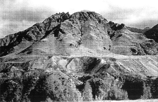
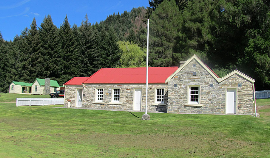
Sign up to hear more
Get the latest heritage news, features and events delivered
straight to your inbox.
