Land surveyors and the use of survey test marks
During the early days of New Zealand settlement land surveyors used a method known as chain surveying to survey the land. Initially this involved using a linked chain, sixty-six feet long and divided into one hundred equal links, known as the Gunter's chain . Then, in approximately 1867-1868, Edwin Fairburn is credited with introducing a steel band, which would later be wound on a drum, to replace this measure. It seems likely that both chains and bands were used in New Zealand for a time with all land surveyors unlikely to immediately be able to secure one of the new designs.
Both chains and bands were subject to wear and tear in the field; the links on Gunter's chains tended to stretch and steel bands were easily broken. Brian Coutts, a Senior Lecturer from the School of Surveying at the University of Otago, reports that steel bands were often repaired if broken in the field, with a candle, solder and a 'joiner' . He also reports that they were subject to expansion and contraction due to temperature changes for which corrections needed to be applied. A chain or band that was the wrong length could significantly affect the accuracy of land surveyors' measurements and so standards were put in place for land surveyors to check their bands or chains against.
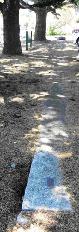
The survey test marks that can be found near Bridge Street, and the mark found nearby Hardy Street, are said to be the standards at which Nelson land surveyors checked the lengths of chains or bands during the settlement of Nelson, that on Bridge Street the earliest, dating from 1877. Similar marks were laid down in each district of the Nelson Region and across New Zealand for the same purpose.
Land surveying in New Zealand
Bar the charting of a few harbours and coastlines, little surveying took place in New Zealand prior to 1840 . It was during the mid nineteenth century as large numbers of principally British immigrants began to settle in New Zealand by way of organised resettlement schemes that the need for professional land surveyors would be felt. Land surveying, 'the practice of measuring angles and distances of land area in order to plot them accurately on a map' would play a significant role in asserting both Crown authority over, and settler ownership of land. As Lawn, the author of a history on pioneer land surveyors in New Zealand, comments 'security of title and facility of land transaction were to depend on accurate surveys and well demarcated boundaries'.
Land surveying in New Zealand was an activity dominated by Europeans largely preoccupied with European interests. Nevertheless it was also an activity that would involve contact, co operation and conflict with Maori. Maori are known to have assisted land surveyors as survey hands or as guides in difficult terrain, and to have offered land surveyors food and shelter in isolated areas. However confrontations and conflicts between land surveyors and Maori were not uncommon. Non violent means such as the pulling up of land surveyors pegs were more common than 'overt hostility' between the parties such as in the case of the Wairau Massacre touched on below. Byrnes, in her book on Land Surveying and the Colonisation of New Zealand notes that 'in almost all examples, surveyors had encroached onto Maori land without permission, or were surveying disputed or confiscated land'. Land surveying was an activity that would have significant consequences for Maori, in particular on their possession of their lands.
Land surveying in early Nelson
Nelson was among four settlements founded by the New Zealand Company, the most significant of the groups involved in organised settlement schemes (their other settlements were at Wellington, Wanganui and New Plymouth). Though Maori had a number of sites in the area of Whakatu (now Nelson city) where they lived seasonally or on a short term basis for food harvesting the area was not permanently inhabited between the late 1820s and 1830s and was not occupied when the New Zealand Company arrived to form their settlement in 1841. However, it remained an important area to Tasman Bay Maori, particularly for those living at the eastern end at Whakapuaka and other nearby settlements along the shores.
The surveying of the Nelson settlement, under the auspices of the New Zealand Company, began to take place immediately upon the arrival of the preliminary expedition to the area in 1841. Frederick Tuckett, the Principal Surveyor for the New Zealand Company, divided the settlement into eight survey districts. To speed up settlement of the land he dispensed with a triangulation survey instead using the running survey method. This required the laying of a long base line in each survey district for the purpose of bearing control and then from this bearing laying out the land in a series of rectangles measuring seventy-five by sixty nine chains. By April 1842 the New Zealand Company had completed surveying the Nelson town sections and land began to be allocated to Maori and to European settlers. The land surveyors then turned their attention to laying out the suburban and rural sections.
After surveying distant districts of the region the Company found sufficient land for the suburban sections but there was a large shortfall in land for the planned rural sections. In February 1843, on confirming that the Wairau Valley contained approximately 200,000 acres of suitable land, the New Zealand Company set out to secure it. They called for tenders for the surveying of the land in March 1843 - this 'despite the oft-repeated objections of Ngati Toa chiefs' Te Rauparaha and Te Rangihaeata, who asserted that they were the principal owners of the Wairau. Te Rauparaha and Te Rangihaeata made deputations to William Spain who was investigating the Company's Cook Strait claims on behalf of the Government. Ngati Toa parties also obstructed the land surveyors' work. Spain's investigation proceeded slowly. After telling Te Rauparaha and Te Rangihaeata that he would not be able to give them an answer until July and to allow the surveying of the land to continue, Ngati Toa escorted the land surveyors from the land, removing survey poles and burning huts. The authorities in Nelson decided that action should be taken against Ngati Toa for the disruption and a party set out to arrest Te Rauparaha and Te Rangihaeata for arson. The ensuing confrontation resulted in the deaths of a number of Maori and Europeans.
The New Zealand Company already faced, and after Wairau would continue to face, financial difficulties. Among other financial concerns they had to support labourers brought in for agricultural work for a longer period than they anticipated, there being little rural land available. The land surveyors continued to search the hinterlands for suitable agricultural land and though there were a number of expeditions none met with much success. After having to suspend its operations in 1844 the Company obtained a loan from the Government to enable it to resume its operations in 1845. It did eventually obtain rural land in Wairau, purchasing sufficient land to meet its obligations to settlers from the Crown in 1847, the Crown having subsequently 'purchased' the land. However the Company's financial problems continued. Under the terms of agreement for another loan from the Government in 1847 the Company agreed to hand over its assets and liabilities to the Government if it could not continue its operations within 3 years. The probation period expired in April 1850 and in 1851 the Company surrendered its Charter to the Government, terminating its existence.
Land surveying bodies in New Zealand
Throughout this period land surveying in New Zealand was conducted by different bodies. All land, bar that vested in the New Zealand Company, was surveyed by government agents. With the division of the colony into the two provinces New Munster and New Ulster in 1846 this was the responsibility of the surveyor-general. However, as discussed, land owned by the New Zealand Company, such as that in Nelson, was surveyed by their agents. Land surveying during the 1840s was as Byrnes, in her book on land surveying and the colonisation of New Zealand, suggests 'ad-hoc'. However differences in the bodies in charge of land surveying and the methods they employed would continue long after the termination of the New Zealand Company in 1851 with the surveyor-general responsible for all land for only a brief period with the appointment of a provincial government system in 1853. From this time each province was responsible for surveying their own lands and each had their own chief surveyor.
Confusion caused by the multitudes of bodies and methods involved in land surveying continued and by the 1860s public concern over the matter was growing. In 1873 the chief surveyors of the provinces met and recommended that a general survey system be established. The Government subsequently seized on a opportunity to gain the opinion of Major A S Palmer, an eminent English surveyor, when he visited New Zealand in late 1874 to observe the transit of Venus. Palmer's report, on the state of land surveying in the provinces, was scathing of the systems in place across the country. Only in Otago did he find a system he was satisfied with. On Nelson he commented that it had 'drifted into a greater state of confusion than in any other province'.
The plan suggested by the chief surveyors in 1873 for a general survey system was ultimately adopted in 1876 on the abolition of provincial government. A national survey system and a single body to manage it - the Lands and Survey Department - were introduced. John Turnbull Thomson was appointed as surveyor-general. On his appointment in 1876 Thomson made a tour of all the provinces to examine the state of the survey in each. In a report to Government he made recommendations on 'a better system of survey'. The new survey system, approved by Government, was based on a standardised system of triangulation that Thomson had used successfully in Otago. This was the same method originally rejected by the New Zealand Company in Nelson for expediency.
The survey test marks within Albion Square
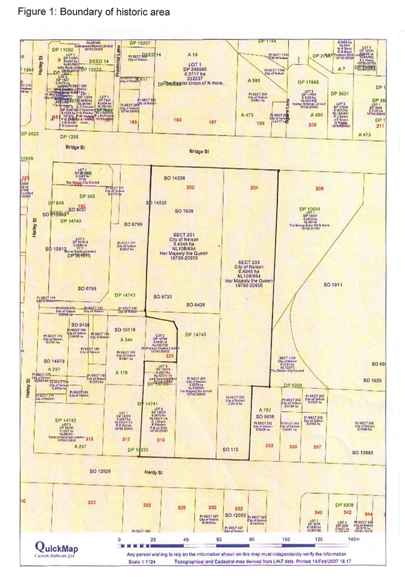
Thomson's visit to Nelson in late 1876, and the prior criticism of the state of Nelson's survey, seems likely to have prompted the laying of the survey test marks in 1877 to assist with triangulation work in the area. The survey test marks would be laid on Section 201 and Section 203 within Albion Square. Section 203 was originally a native reserve but was exchanged for Section 733, a European section, in 1848 to enable the Nelson School Committee [Society], who ran the Matthew Campbell School, to enlarge their premises (though no reference has been found to them ever building there).
John Samuel Browning was appointed as Chief Surveyor of Nelson Land District by Nelson Provincial Council in 1876 and he would continue in the equivalent role when control passed to the Lands and Survey Department that same year. He worked to bring the survey information for the district together and to update the maps. Land surveying activity in Nelson during this time concentrated on connecting Nelson to adjoining provinces by road or rail and opening up access to the backcountry of the province. Two significant works that took place under the direction of Browning and John George Blackett, Resident Engineer, were the building of the main highways from Nelson to Lyall on the Buller River, and from Nelson to Blenheim via the Rai Valley.
Browning retired in 1896 and was succeeded by Thomas Humphries. It is likely that it was during Humphries time managing land surveying in the district that the other of the survey test marks still visible in Albion Square was laid down. The five-chain base was reportedly established in 1902 after further checks on the standard length in use revealed slight differences to the Imperial Standard. It is also reported that the standardisation or recalculation of the triangulation was completed by Messrs Humphries, Pollock Robinson, Dickie Wilson and Kelly.
Little more is known about the use of the marks by land surveyors or when they fell into disuse. However, a more recent event is associated with the marks on Bridge Street. On the 4 September 1988, on the occasion of their centenary, the New Zealand Institute of Surveyors commemorated these marks commenting that they were 'formerly the standard for Nelson land title measurement'. To the east of the marks they erected a plaque and buried a time capsule (see Appendix 4; Figure 6 of the registration report for an image of the plaque). The capsule includes contributions from the Nelson Branch of the New Zealand Institute of Surveyors Nelson, the Department of Survey and Land Information, local city, borough and county councils, and a number of individuals and local schools. The capsule is due to be opened on the bicentenary of the New Zealand Institute of Surveyors in 4 September 2088. Perhaps there is material buried in this capsule that will shed more light on the marks and the land surveyors that used them.