

Mt Cook was originally Pukeahu, a pa occupied intermittently by Maori. In 1843 troops were brought in to protect Wellington from potentially hostile Maori and occupied the hill, the beginning of a long military association with the area. The hill was later occupied by barracks, a magazine and a prison. In 1843, barracks were built to accommodate Imperial troops assigned to protect Wellington during the New Zealand Wars. After the troops left in 1865 the barracks housed immigrants. In 1879 the building was demolished, more levelling took place and a huge gaol was built by prisoners from the nearby Terrace Gaol. Only one wing of six planned was built (c.1882) and the prison finally closed by 1900. The building was taken over by the Army for use as barracks and it was not until 1930 that it was finally demolished to make way for the National War Memorial and Dominion Museum.
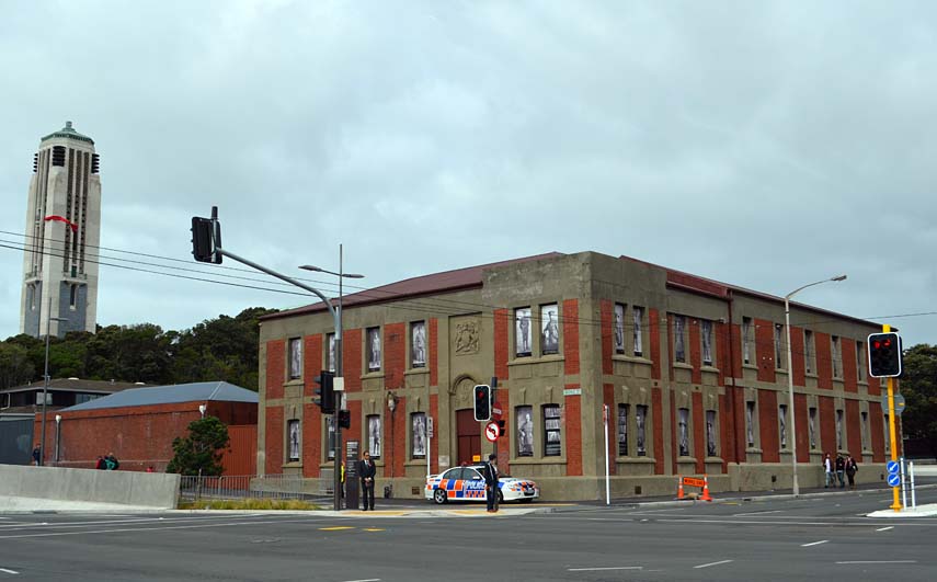
The oldest part of the wall dates from at least 1891, and perhaps earlier. Built by prisoners who made the bricks on site at Mt Cook, the first section of wall built was at the northern end. It was extended further north to meet the Mt Cook Police Station in 1893/94 and after a period of work in 1896 the last section was built some time after 1897 and completed by 1899. The wall has been altered in places, particularly by the addition of two stairs, at least one of which was built to give access to air raid shelters constructed in 1942. A sub-station was built in the wall in 1965 and courses of brick were added to the southern end of the wall during the 1940s.
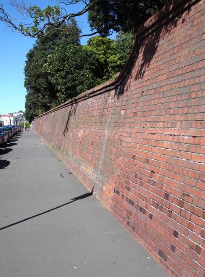
The wall is a gravity wall i.e. it uses its sheer bulk to retain the earth behind. This approach is enhanced by the rake (or tilt) of the wall, which acts like a buttress. The construction is English bond - alternating courses of headers and stretchers. The wall is interrupted in three places; by two stairs and a sub-station. The wall is at its highest at the northern end, where the land rises above the former police station. It is at its lowest at the southern end, where the wall retains two tennis courts.
Brick walls of the age of the Tasman Street Wall are very rare in Wellington and there is almost certainly nothing of this size in the city. It is likely to be rare nationally. While the wall is a relatively prosaic structure, it is the oldest construction of any type left on Mt Cook Reserve. Its brick construction links it directly to the penal history of the area, to the prisoners who made the bricks and built the wall, and the general era of brickmaking that so characterised this part of Wellington. It is an important historic structure of regional significance.
List Entry Information
Status
Listed
List Entry Status
Historic Place Category 2
Access
Able to Visit
List Number
7758
Date Entered
27th June 2008
Date of Effect
27th June 2008
City/District Council
Wellington City
Region
Wellington Region
Extent of List Entry
Registration includes part of the land described in WN54C/503, WN54D/136, WN6C/802 and New Zealand Gazette 1994, p.2705 and the structure known as Tasman Street Wall. Registration excludes the substation building but includes the surrounding brickwork (Refer to Extent of Registration Map in Appendix 1 of the registration report for further information).
Legal description
Lot 2 DP 87064 (RTs WN54C/503, WN54D/136), Sec 1253 Town of Wellington (RT WN6C/802), Sec 1 SO 36519 (New Zealand Gazette 1994, p.2705), Wellington Land District.
Location Description
West side of Tasman Street between 60 Tasman Street (Massey University carpark) and the former Mt Cook Police Station, corner Buckle Street and Tasman Street
Why is this place significant?
Historic Significance
Historical Significance or Value The wall has historic significance for a number of reasons. Firstly, it is the oldest surviving structure associated with Mt Cook Reserve. It is thought to predate the former Mt Cook Police Station, with which it shares so much in common. So much of the Reserve has changed over its history - the hill itself, the structures on it and the landscaping - that the wall is one of the few constants. The wall is, like the Station, a reminder of the considerable contribution made by the prisoners of the Terrace and Mt Cook Gaols, who made the bricks and built the structures. The wall is the best place in Wellington to see prison bricks, regarded during the time they were made to be a very fine brick. Today they retain a certain caché amongst those who value old bricks.
Physical Significance
AESTHETIC SIGNIFICANCE OR VALUE: The Tasman Street Wall has high aesthetic value, as a lengthy and prominent red brick wall on the boundary of the historic Mt Cook reserve. The brickwork is very competently handled, particularly the pronounced tilt of the wall's construction, the neatly detailed cornice and the conjunction of the wall with that of the Mt Cook Police Station. Red brick structures once dominated this part of Mt Cook, appropriately so given that the Mt Cook clay brick was virtually a vernacular building material. There are still red brick structures in the vicinity, including the former defence General Headquarters Building at the western end of Buckle Street, but it is the combination of the wall and Mt Cook Police Station which is particularly distinctive and pleasing. The wall, as viewed from the eastern side of Tasman Street, has (for some of its length) a backdrop of maturing bush, planted following the construction of the National Museum and National War Memorial in the 1930s, and a prominent feature of the eastern flanks of Mt Cook. With the minor exception of the sub-station opposite the intersection with Rugby Street, views of the wall are unencumbered by buildings. ARCHAEOLOGICAL SIGNIFICANCE OR VALUE: The wall has some archaeological value. Archaeological analysis of the wall can provide information about the differing periods of construction of the wall and changes in construction technique over time. Analysis of the bricks themselves could provide information on the source of the clay obtained as well as details of the manufacturing process. The main archaeological value of the wall is as a feature of the historic landscape in which it sits - it represents a particular period of occupation and use of this part of Mt Cook. The wall itself, therefore, has some archaeological value but the wall should be considered to be a feature of the wider archaeological site complex associated with it. TECHNOLOGICAL SIGNIFICANCE OR VALUE: The wall has technological significance for the use of brick construction to retain a bank. There are a number of matters of importance. As brick historian Gary Tonks has noted, the wall is a technically fine example of brick construction, which was 'built with pride and demonstrates artisan workmanship'. Of particular interest is the rake of the wall, which required the bricks to be laid on a shallow angle. Although not unusual, it is well handled, certainly when contrasted with the work on the 1969 sub-station. The wall demonstrates 19th and early 20th century techniques in brick wall retaining that are rare in Wellington. Although no survey has been undertaken, there are likely to be few other examples left, and none of this length. The only examples discovered thus far (apart from the retaining walls for the Mt Cook Police Station itself) are the shorter, but taller wall built for the Mt View Asylum c.1897 (Government House grounds), the lower and shorter Ira Street wall (1924) in Miramar and the retaining wall built behind some of the 'Seven Sisters' houses on Oriental Parade (pre-1907). However, there are retaining walls built of concrete in many parts of Wellington.
Why is this place Category 1 / Category 2?
Detail Of Assessed Criteria
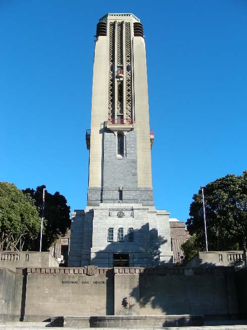
(a) The association of the place with events, persons, or ideas of importance in New Zealand history: The Tasman Street Wall is not in itself a place of great historic importance, but its association with this precinct, and its construction during the period of prison use tells an important part of the remarkable story of Mt Cook. As a structure formed of prison-made bricks and constructed by prisoners, it is a reminder of 19th century criminal justice and punishment practices; a time when prisoners were expected to do hard labour as their repayment to society. With no structure other than the Mt Cook Police Station still standing on site from that period of use, the wall is a hugely important relic. (c) The potential of the place to provide knowledge of New Zealand history: The wall has the potential to provide knowledge of the past uses of this area, in particular the construction, use of, and changes to the wall. The immediate environs of the wall might also yield information of past uses, given the long history of occupation of Mt Cook. Those uses in the immediate area include the construction of a road in the 1840s from Tasman Street to Mt Cook via the magazine, and the building of the air raid shelters in 1942. (e) The community association with, or public esteem for the place: The wall is a prominent structure in Mt Cook and well known to most people in the area. It is particularly familiar to those who live in Tasman Street or nearby and for those who use the wall to gain access to the buildings above. The prison bricks are a particular attraction for some. Frequently individuals or groups can be seen peering at bricks to see the prison mark, while heritage trails occasionally take groups to the wall. The wall will feature in the next reprint of the Te Aro Heritage Trail. In addition, the Wellington City Council has included the wall as a listed item in the operative District Plan since 1995. (f) The potential of the place for public education: The wall and former police station together offer a considerable opportunity for public education on the former uses of the Mt Cook Reserve, prison brickmaking and the general changes to the area. The wall is publicly accessible and the best place in Wellington to view prison bricks. The changes to the wall tell other stories too, including the construction of a set of stairs to give access to World War II air raid shelters. (g) The technical accomplishment or value, or design of the place: The wall demonstrates technical accomplishment on a number of levels. Firstly, the brickwork, with few exceptions, is well done. The rake of the wall, the courses, weep holes and cornices are neatly and accurately finished. The alignment and fall of the wall are particularly significant for the care taken in their execution. Secondly, the wall continues to serve its purpose well, showing no signs of major deterioration in its general form, and demonstrating how well it was constructed. (j) The importance of identifying rare types of historic places: Brick retaining walls are not rare nationally but they are rare in Wellington region. Concerns over the risk of earthquakes and, as a result, a more prevalent use of concrete may partly explain this. However, there are still a number of old buildings in Wellington that retain their brick walls. It is more likely that the manufacture of cheap bricks at Mt Cook made it logical to use it as the retaining material; all the other major structures at Mt Cook were built of bricks. The length of the wall is also a most unusual feature, there being no parallel to it anywhere in Wellington. (k) The extent to which the place forms part of a wider historical and cultural complex or historical and cultural landscape: Tasman Street Wall is just one element of a wider and extremely significant historic and cultural landscape. Mt Cook has been a place of importance to Maori and Pakeha for centuries. Following intermittent Maori occupation as a pa, the hilltop was used for military purposes and then by the Armed Constabulary. No physical reminders of that period survive. The oldest part of the wall is the oldest structure still standing within the reserve, and it dates from the period of penal use, which coincided with the brickmaking undertaken by prisoners from the Terrace and Mt Cook gaols. Apart from the adjacent Mt Cook Police Station and nearby Army General Headquarters building, no other structures on the reserve still stand from the period before the building of the National War Memorial in 1931. The Tasman Street Wall remains an integral part of the wider heritage landscape, serving as eastern bulwark to the National War Memorial and Carillon, while offering a tangible link back to the earlier history of the site. SUMMARY OF SIGNIFICANCE OR VALUES: This place was assessed against, and found it to qualify under the following criteria: a, c, e, f, g, j, k CONCLUSION: It is considered that this place qualifies as a Category II historic place. Brick walls of the age of the Tasman Street Wall are very rare in Wellington and there is almost certainly nothing of this size in the city. It is likely to be rare nationally. While the wall is a relatively prosaic structure, it is the oldest construction of any type left on Mt Cook Reserve. Its brick construction links it directly to the penal history of the area, to the prisoners who made the bricks and built the wall, and the general era of brickmaking that so characterised this part of Wellington. It is an important historic structure of regional significance.
Why is this place significant?
Historic Significance
Historical Significance or Value The wall has historic significance for a number of reasons. Firstly, it is the oldest surviving structure associated with Mt Cook Reserve. It is thought to predate the former Mt Cook Police Station, with which it shares so much in common. So much of the Reserve has changed over its history - the hill itself, the structures on it and the landscaping - that the wall is one of the few constants. The wall is, like the Station, a reminder of the considerable contribution made by the prisoners of the Terrace and Mt Cook Gaols, who made the bricks and built the structures. The wall is the best place in Wellington to see prison bricks, regarded during the time they were made to be a very fine brick. Today they retain a certain caché amongst those who value old bricks.
Physical Significance
AESTHETIC SIGNIFICANCE OR VALUE: The Tasman Street Wall has high aesthetic value, as a lengthy and prominent red brick wall on the boundary of the historic Mt Cook reserve. The brickwork is very competently handled, particularly the pronounced tilt of the wall's construction, the neatly detailed cornice and the conjunction of the wall with that of the Mt Cook Police Station. Red brick structures once dominated this part of Mt Cook, appropriately so given that the Mt Cook clay brick was virtually a vernacular building material. There are still red brick structures in the vicinity, including the former defence General Headquarters Building at the western end of Buckle Street, but it is the combination of the wall and Mt Cook Police Station which is particularly distinctive and pleasing. The wall, as viewed from the eastern side of Tasman Street, has (for some of its length) a backdrop of maturing bush, planted following the construction of the National Museum and National War Memorial in the 1930s, and a prominent feature of the eastern flanks of Mt Cook. With the minor exception of the sub-station opposite the intersection with Rugby Street, views of the wall are unencumbered by buildings. ARCHAEOLOGICAL SIGNIFICANCE OR VALUE: The wall has some archaeological value. Archaeological analysis of the wall can provide information about the differing periods of construction of the wall and changes in construction technique over time. Analysis of the bricks themselves could provide information on the source of the clay obtained as well as details of the manufacturing process. The main archaeological value of the wall is as a feature of the historic landscape in which it sits - it represents a particular period of occupation and use of this part of Mt Cook. The wall itself, therefore, has some archaeological value but the wall should be considered to be a feature of the wider archaeological site complex associated with it. TECHNOLOGICAL SIGNIFICANCE OR VALUE: The wall has technological significance for the use of brick construction to retain a bank. There are a number of matters of importance. As brick historian Gary Tonks has noted, the wall is a technically fine example of brick construction, which was 'built with pride and demonstrates artisan workmanship'. Of particular interest is the rake of the wall, which required the bricks to be laid on a shallow angle. Although not unusual, it is well handled, certainly when contrasted with the work on the 1969 sub-station. The wall demonstrates 19th and early 20th century techniques in brick wall retaining that are rare in Wellington. Although no survey has been undertaken, there are likely to be few other examples left, and none of this length. The only examples discovered thus far (apart from the retaining walls for the Mt Cook Police Station itself) are the shorter, but taller wall built for the Mt View Asylum c.1897 (Government House grounds), the lower and shorter Ira Street wall (1924) in Miramar and the retaining wall built behind some of the 'Seven Sisters' houses on Oriental Parade (pre-1907). However, there are retaining walls built of concrete in many parts of Wellington.
Why is this place Category 1 / Category 2?
Detail Of Assessed Criteria
(a) The association of the place with events, persons, or ideas of importance in New Zealand history: The Tasman Street Wall is not in itself a place of great historic importance, but its association with this precinct, and its construction during the period of prison use tells an important part of the remarkable story of Mt Cook. As a structure formed of prison-made bricks and constructed by prisoners, it is a reminder of 19th century criminal justice and punishment practices; a time when prisoners were expected to do hard labour as their repayment to society. With no structure other than the Mt Cook Police Station still standing on site from that period of use, the wall is a hugely important relic. (c) The potential of the place to provide knowledge of New Zealand history: The wall has the potential to provide knowledge of the past uses of this area, in particular the construction, use of, and changes to the wall. The immediate environs of the wall might also yield information of past uses, given the long history of occupation of Mt Cook. Those uses in the immediate area include the construction of a road in the 1840s from Tasman Street to Mt Cook via the magazine, and the building of the air raid shelters in 1942. (e) The community association with, or public esteem for the place: The wall is a prominent structure in Mt Cook and well known to most people in the area. It is particularly familiar to those who live in Tasman Street or nearby and for those who use the wall to gain access to the buildings above. The prison bricks are a particular attraction for some. Frequently individuals or groups can be seen peering at bricks to see the prison mark, while heritage trails occasionally take groups to the wall. The wall will feature in the next reprint of the Te Aro Heritage Trail. In addition, the Wellington City Council has included the wall as a listed item in the operative District Plan since 1995. (f) The potential of the place for public education: The wall and former police station together offer a considerable opportunity for public education on the former uses of the Mt Cook Reserve, prison brickmaking and the general changes to the area. The wall is publicly accessible and the best place in Wellington to view prison bricks. The changes to the wall tell other stories too, including the construction of a set of stairs to give access to World War II air raid shelters. (g) The technical accomplishment or value, or design of the place: The wall demonstrates technical accomplishment on a number of levels. Firstly, the brickwork, with few exceptions, is well done. The rake of the wall, the courses, weep holes and cornices are neatly and accurately finished. The alignment and fall of the wall are particularly significant for the care taken in their execution. Secondly, the wall continues to serve its purpose well, showing no signs of major deterioration in its general form, and demonstrating how well it was constructed. (j) The importance of identifying rare types of historic places: Brick retaining walls are not rare nationally but they are rare in Wellington region. Concerns over the risk of earthquakes and, as a result, a more prevalent use of concrete may partly explain this. However, there are still a number of old buildings in Wellington that retain their brick walls. It is more likely that the manufacture of cheap bricks at Mt Cook made it logical to use it as the retaining material; all the other major structures at Mt Cook were built of bricks. The length of the wall is also a most unusual feature, there being no parallel to it anywhere in Wellington. (k) The extent to which the place forms part of a wider historical and cultural complex or historical and cultural landscape: Tasman Street Wall is just one element of a wider and extremely significant historic and cultural landscape. Mt Cook has been a place of importance to Maori and Pakeha for centuries. Following intermittent Maori occupation as a pa, the hilltop was used for military purposes and then by the Armed Constabulary. No physical reminders of that period survive. The oldest part of the wall is the oldest structure still standing within the reserve, and it dates from the period of penal use, which coincided with the brickmaking undertaken by prisoners from the Terrace and Mt Cook gaols. Apart from the adjacent Mt Cook Police Station and nearby Army General Headquarters building, no other structures on the reserve still stand from the period before the building of the National War Memorial in 1931. The Tasman Street Wall remains an integral part of the wider heritage landscape, serving as eastern bulwark to the National War Memorial and Carillon, while offering a tangible link back to the earlier history of the site. SUMMARY OF SIGNIFICANCE OR VALUES: This place was assessed against, and found it to qualify under the following criteria: a, c, e, f, g, j, k CONCLUSION: It is considered that this place qualifies as a Category II historic place. Brick walls of the age of the Tasman Street Wall are very rare in Wellington and there is almost certainly nothing of this size in the city. It is likely to be rare nationally. While the wall is a relatively prosaic structure, it is the oldest construction of any type left on Mt Cook Reserve. Its brick construction links it directly to the penal history of the area, to the prisoners who made the bricks and built the wall, and the general era of brickmaking that so characterised this part of Wellington. It is an important historic structure of regional significance.
Construction Details
Start Year
1931
Type
Other
Description
Alexandra Barracks is demolished in preparation for the building of the National War Memorial & National Art Gallery & Dominion Museum.
Start Year
1931
Type
Other
Description
Spoil from the excavations for the Memorial is used to make the Tasman Street bank more uniform.
Start Year
1942
Type
Modification
Description
Emergency air raid shelters constructed on the eastern side of Mount Cook Reserve and access steps are cut into the Tasman Street Wall
Start Year
1942
Type
Modification
Description
Wellington Technical College builds tennis courts on the former section of Crown land on the south-eastern corner of the Mount Cook Reserve and additional courses of brick are laid to retain the raised platform
Start Year
1969
Type
Demolished - Other
Description
The Tasman Street Wall is partly demolished and a substation built
Start Year
2004
Type
Other
Description
Massey University art students paint sections of cement mortar on the wall.
Start Year
2006
Type
Other
Description
Massey University arranges for the sand blasting of graffiti off the middle section of the wall.
Type
Other
Description
Brick, tile, and drain-pipe production begins at Mount Cook Reserve using prison labour from The Terrace Gaol
Period
Late 1870s
Start Year
1882
startYearCirca
Type
Other
Description
Construction of the Mount Cook Gaol begins using bricks manufactured at the site
Start Year
1884
Type
Other
Description
Hoffmann kiln is built at Mount Cook Reserve
Type
Original Construction
Description
First (northern) section of the Tasman Street Wall completed
Period
By 1891
Start Year
1893
Type
Addition
Description
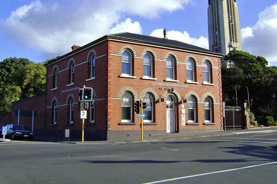
Construction begins on the Mount Cook Police Station that abuts the Tasman Street Wall (finished early 1894). The wall is extended from the Station to meet the existing wall
Start Year
1896
Type
Addition
Description
2 March-6 May period of construction on the wall
Start Year
1897
Type
Other
Description
Construction of Mount Cook Gaol ceases with only one major wing completed
Type
Original Construction
Description
Tasman Street Wall completed after urgings (in 1897) by the Wellington City Council
Period
By 1899
Start Year
1924
Type
Other
Description
Approximate date for the construction of the first steps, near the intersection with Rugby and Tasman Sts, which takes pedestrians via a path to the Wellington Technical School, newly established on Mt Cook
Construction Materials
Bricks, cement mortar and concrete. Construction Professionals: Not known, although prisoners at the Terrace Gaol made the bricks and constructed the wall. The design may have been the work of Bryen Weyburne, inspector of works at Mount Cook Gaol.
Construction Details
Start Year
1931
Type
Other
Description
Alexandra Barracks is demolished in preparation for the building of the National War Memorial & National Art Gallery & Dominion Museum.
Start Year
1931
Type
Other
Description
Spoil from the excavations for the Memorial is used to make the Tasman Street bank more uniform.
Start Year
1942
Type
Modification
Description
Emergency air raid shelters constructed on the eastern side of Mount Cook Reserve and access steps are cut into the Tasman Street Wall
Start Year
1942
Type
Modification
Description
Wellington Technical College builds tennis courts on the former section of Crown land on the south-eastern corner of the Mount Cook Reserve and additional courses of brick are laid to retain the raised platform
Start Year
1969
Type
Demolished - Other
Description
The Tasman Street Wall is partly demolished and a substation built
Start Year
2004
Type
Other
Description
Massey University art students paint sections of cement mortar on the wall.
Start Year
2006
Type
Other
Description
Massey University arranges for the sand blasting of graffiti off the middle section of the wall.
Type
Other
Description
Brick, tile, and drain-pipe production begins at Mount Cook Reserve using prison labour from The Terrace Gaol
Period
Late 1870s
Start Year
1882
startYearCirca
Type
Other
Description
Construction of the Mount Cook Gaol begins using bricks manufactured at the site
Start Year
1884
Type
Other
Description
Hoffmann kiln is built at Mount Cook Reserve
Type
Original Construction
Description
First (northern) section of the Tasman Street Wall completed
Period
By 1891
Start Year
1893
Type
Addition
Description
Construction begins on the Mount Cook Police Station that abuts the Tasman Street Wall (finished early 1894). The wall is extended from the Station to meet the existing wall
Start Year
1896
Type
Addition
Description
2 March-6 May period of construction on the wall
Start Year
1897
Type
Other
Description
Construction of Mount Cook Gaol ceases with only one major wing completed
Type
Original Construction
Description
Tasman Street Wall completed after urgings (in 1897) by the Wellington City Council
Period
By 1899
Start Year
1924
Type
Other
Description
Approximate date for the construction of the first steps, near the intersection with Rugby and Tasman Sts, which takes pedestrians via a path to the Wellington Technical School, newly established on Mt Cook
Construction Materials
Bricks, cement mortar and concrete. Construction Professionals: Not known, although prisoners at the Terrace Gaol made the bricks and constructed the wall. The design may have been the work of Bryen Weyburne, inspector of works at Mount Cook Gaol.
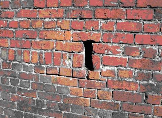
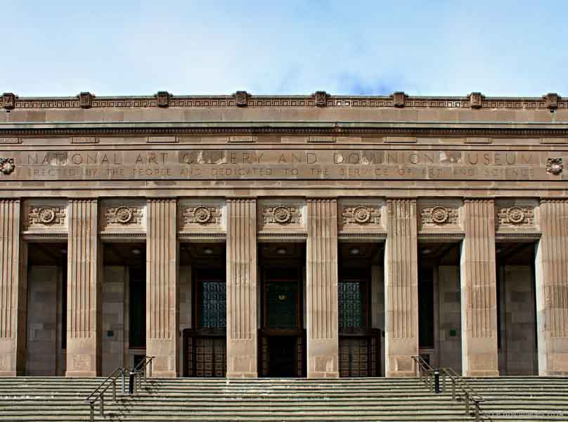
Tasman Street Brick Wall is part of a wider assemblage of buildings and structures that occupy what was once Mt Cook Reserve. The brick wall was built by prisoners in three parts (c.1891, 1893/94 and c.1903) and is today the oldest structure associated with the Reserve. MOUNT COOK RESERVE: The Tasman Street Wall retains the eastern base of Mount Cook Reserve, an area described by Premier Richard Seddon as 'the noblest site in Wellington.' Mt Cook is the European name for a hill, Pukeahu, which was the site of a pa, long abandoned by the time of European settlement. It was renamed by settlers after Captain James Cook. The New Zealand Company saw a military use for it, as the Company's 1840 map shows the hill reserved for military purposes. British troops were stationed there temporarily in 1843 to protect Wellington from potentially hostile Maori in the wake of the Wairau 'Massacre'. Governor Grey reserved the land for military purposes in 1850. After the troops left in 1865 the barracks housed immigrants. In 1879 the building was demolished, more levelling took place and a huge goal was built by prisoners from the nearby Terrace Gaol, using bricks made on site at Mt Cook. Only one wing of the six planned was built (c 1882) and the prison finally closed by 1900. During this period the prisoners working the Mt Cook brickworks made millions of bricks for government and private construction. The prison building was taken over by the Army for use as barracks and it was not until 1930 that it was finally demolished. In 1893/94, the Mount Cook Police Station was built on the north-eastern corner of the reserve, at the junction of Buckle and Tasman Streets. The Station and wall are today the oldest structures associated with the Mt Cook Reserve. In 1924 the Government decided to build a new museum on Mt Cook to replace the overcrowded Colonial Museum, near Parliament. In 1928 it was decided to combine the museum with the National Art Gallery and build the National War Memorial on the same site. The Carillon, part of the National War Memorial, opened in 1932, despite not being completed. The Hall of Memories was finally built in 1964. Construction of the Dominion Museum (later National Museum) began in 1932 and officially opened in August 1936. The museum was closed during World War II and used a military headquarters. It did not reopen until 1949. A network of underground emergency shelter tunnels was built in the reserve in 1942. Steps cut into the Tasman Street Wall date from this work and were access ways to the tunnels. In 1996 the National Museum closed preparatory to a move to the new Museum of New Zealand - Te Papa - on Wellington's waterfront. This took place in 1998, and in 1999 the old Museum was purchased by the Wellington Tenths Trust. Massey University merged with the Wellington Polytechnic and took over the old building, which reopened in 2001 after considerable restoration and refurbishment. LATE NINETEENTH CENTURY BRICK-MAKING: Tasman Street Wall is primarily associated with the Reserve's penal and brick-making past. The distinctive prison bricks used in construction of the wall and also the Mount Cook Police Station/Barracks can be identified by their incised broad arrow. The arrow denoted property of the Crown, and was first used in Britain in the 17th century. It became the standard mark of government property, but only became widely used on prison garb in the 1870s. Its adoption in New Zealand was a natural extension of British practices. Use of the arrow was discontinued in Britain in the 1920s. The bricks were made on site at the prison industry workshop and kiln at Mount Cook Reserve from the late 1870s onwards. The suitability and easy availability of its clay made Mt Cook the centre of Wellington brick-making in the late 19th and early 20th centuries. There were a number of brick-making businesses in the area, particularly on Taranaki Street, Adelaide Road and Wallace Street, but the Mount Cook Gaol was the most important enterprise of all. The brickworks at Mt Cook Reserve had several advantages over its competitors in the area. The most obvious was the readily available, cheap work force, in the form of hard labour and penal servitude prisoners. Also, by 1884, the bricks were being fired in a Hoffmann kiln, at the time one of only two operational in Wellington. The Hoffmann kiln was patented by Frederich Hoffmann in 1856 and was revolutionary because it enabled continuous production. As a result it offered further advantage to the Mt Cook Gaol as traditional kilns could only fire one batch of bricks at one time. This meant that production was not only slower, but the process also used more fuel as the kiln had to be reignited after each firing, making this method less economical than Hoffmann's new kiln design. The continuous production of the Hoffmann kilns, like the large one at Mt Cook, was the result of its special features, including a series of compartments which could be loaded externally and firing operating on rotation. The latter meant that at any time the kiln could contain 'green' bricks, bricks which were drying out in preparation for firing, bricks being fired, bricks which were cooling, and completed bricks which were being emptied from the kiln. As a result, Hoffmann kilns increased production and manufactured bricks that were generally of a higher quality than other methods. By the mid-1880s the Mount Cook Reserve Hoffmann kiln could produce approximately two million bricks per annum, with prisoners from The Terrace Gaol marching to the site each day to provide the necessary manual labour. In 1885, Arthur Hume, the Inspector of Prisons, reported that: Various tests of the quality of these bricks have been made by competent official authority, which has pronounced them superior to anything of the kind previously produced by private enterprise. He continued in this vein in 1887 by proclaiming that the bricks were 'universally admitted to be the best ever manufactured in the colony.' The clay was taken largely from the south-western face of Mt Cook, which eventually created what are today Wellington High School's playing fields. Production at the site continued despite the prison being officially closed in 1900 and eventually re-designated as the Alexandra Barracks. Brick production gradually diminished to the point that in 1918 it was estimated that only 820,000 bricks would be manufactured that year and that the clay supply would soon be exhausted. It was suggested that clay could be excavated from the bank behind the Tasman Street Wall. However, this was halted by the Wellington City Council District Engineer, who wanted the bank to maintain its form as part of an 'improvement scheme' which was to be undertaken on the Tasman Street frontage. It is assumed that the kiln was demolished in 1920, at the same time the old prison was pulled down. Three significant structures at Mt Cook were constructed from prison bricks: the Mt Cook Gaol (later Alexandra Barracks), the Mt Cook Police Station (Register no. 1408) and the Tasman Street Wall. Other buildings in Wellington which were made from the Mount Cook prison bricks included the Parliamentary Library (Register No 217), the Wellington Harbour Board Wharf Office Building (Register No 1446), Wellington Public Hospital (now demolished), the Government Print Office, and the fortifications at Fort Ballance (Register No 5074). Bricks were also supplied for projects such as the Wellington and Manawatu Railway, as well as to private companies on occasion. TASMAN STREET WALL: Despite the kiln's large output, completion of some projects in the immediate vicinity, namely the new Mount Cook Gaol and the Tasman Street Wall, were stalled for years, and in the case of the gaol, were never completed. As noted, the Mount Cook Gaol was begun c.1882 but only one wing was built. Shortage of funds and using prison labour prevented it being built quickly (it was reported as only being up to the second-storey of one wing by 1888). Construction was finally abandoned in 1897. The construction delays caused much frustration for Hume who consistently stressed the need for his new gaol to alleviate the woeful conditions at The Terrace Gaol. The Tasman Street Wall was identified as first appearing on a plan in 1891 in an incomplete state and remained this way until at least 1897 when, in response to lobbying from Mt Cook residents, the city council approached the government urging them to complete the project. It seems likely that the government responded to this request in due course, as the Engineer-in-Chief Public Works Department reported the retaining wall on Tasman Street as completed in 1899. The delays that these projects faced appear to have been due to demand for prison bricks and labour elsewhere. In the last decades of the 19th century the government placed particular importance on fortification projects in light of the perceived Russian threat, which diverted resources and resulted in the building of structures like that at Fort Ballance.22 Also, the immediate completion of the Tasman Street Wall may have been affected by the fact that in 1891, by the time the first section was completed, production of the prison bricks stopped. The reasons cited for this cessation were increased fuel costs and labour troubles, however, these issues were resolved and production had resumed by the next year. A typhoid epidemic in 1892, which cleared the Mt Cook site, no doubt further slowed construction progress. As a result of this epidemic, further effort was diverted into completing drainage works at the barracks and prison building. No designer has been identified for the wall although the Mt Cook Police Station was designed by Bryen Weyburne, inspector of works at Mount Cook Gaol. It is possible that he was also responsible for the design of at least the first section of the wall, which predated the building. The construction work was completed by prison labour, which would have been supervised by the prison overseer. No pre-construction plans have been found for the wall, possibly because its construction was considered a fairly prosaic matter. There were various construction periods, including (by) 1891, 1893/94 and (by) 1899. In 1896 a dozen free labourers were also employed to work on the wall from 2 March-6 May, at the same time as working on the approach road to the prison. The bricks were made on site at Mt Cook from local clay, which would have been ground into a fine mixture before being mixed with water and formed by a mould into the familiar brick form. Many of the bricks show evidence that they were partly formed from crushed and reused older bricks i.e. there are chunks of old brick lying within the fired brick. In addition, brick historian Gary Tonks has identified that the surface of some of the bricks shows the finger impressions of the men who handled the bricks when moist, prior to firing. The topography of the land the wall retained was much different from what it is today. The land behind the wall was once much steeper in places. A photograph taken in 1926 shows a bank rising directly behind the wall not far from the Rugby Street intersection (see Appendix 2, Figure 6). Today there is a wide platform behind the wall, probably formed when the excavations were made for air raid shelters in 1942 (see below). In the century since the wall's completion, there have been no alterations to the form of the earlier portion of the wall. However, changing uses of Mt Cook Reserve have led to additions and modifications to the later section. In some cases it is difficult to fix the date of these changes. Today, a set of stairs and path leave the wall and heads in a south-westerly direction to the top of the hill (see Appendix 2, Figure 16). There was originally a road in this vicinity, formed in the 1840s, and it provided access from the hilltop to a magazine (c.1847) halfway down the hill (where a prefab building stands today) and then on to Banks Terrace (as Tasman Street was once known). It is likely that the path was formed across the reserve to provide access from Tasman Street to the Wellington Technical College, which moved to Mt Cook in 1922. It is possible that access was provided to the path from Tasman Street from the time the wall was completed around the turn of the 19th century, but it is more likely to date from the mid-1920s. A clue to its origins is that the stair is lined with red bricks (and well constructed) but not prison-made i.e. there are no arrows on them. Also, part way up the stairs are cavities in the brick wall (two on the north side and one on the south) that were almost certainly used to house fixings for a gate (see Appendix 2, Figure17). Some time in the early 1940s Wellington Technical College built tennis courts on the land to the immediate south of the path. It appears as if the path was simply used as a convenient boundary. The site was not level, but rather than cut down the bank below the existing level of the Tasman Street Wall, the land was built up to form a uniform height for the two courts. The fill for this may have come from excavations into the hill to form the courts. As a result, additional courses of brickwork were added to the top of the existing prison brick wall to retain the north court (see Appendix 2, Figure 20). It is possible that the concrete wall on the southern boundary of the reserve (the northern boundary of 60 Tasman St) was formed at this time to retain the fill (see Appendix 2, Figure 20). In 1942, with the Japanese threat at its highest, air raid shelters were built in many parts of Wellington, including the grounds of Dominion Museum. Four shelters were built on the eastern side of the Mt Cook, just above the Tasman Street Wall. To gain access to the shelters, steps were cut from Tasman Street, about halfway down the wall's length (see Appendix 2, Figure 13). These steps later provided another access point to the museum, and more recently the Massey University campus. The next significant modification to the form of the wall was the construction of a substation for the WCC's Municipal Electricity Department in 1969. Land was purchased from the Crown for the purpose, at a cost of £227, in November 1968, although Wellington High School did object to the taking of its land when the proposal was first raised in 1965. Positioned to the immediate south of the c.1924 steps, the substation is set into the side of the hill and as such, a portion of the prison brick wall had to be removed to make room for it (see Appendix 2, Fig.18). A new path to the tennis courts was also formed, leading to the entrance gate immediately perpendicular to the top of the wall (see Appendix 2, Fig.1). In 1978, the Wellington Regional Committee of the Historic Places Trust became involved in the restoration and refurbishment of the Mt Cook Police Station. During this work, considerable interest was focussed on the prison bricks used to construct the building. The Tasman Street Wall, seen as an adjunct of the Station, also received some attention at the time. However, it was not until 1995 that the wall's heritage value was formally recognised when it was included as an object on the Wellington City Council's District Plan. Part of the site is now half-owned by Massey University with the Wellington Tenths Trust, who lease the remainder back to the University. The Trust purchased the site in 1997 with the proceeds of their successful Treaty of Waitangi claim and an undisclosed half was on sold to Massey University. The remainder of the site was reserved by the Crown for secondary school purposes and is occupied by Wellington High School, except for the portion of the wall that is occupied by the substation which is owned by Vector Limited. This area, which encompasses the Tasman Street Wall, the Mount Cook Police Station (Register No 1408), National War Memorial and Carillion (Register No 1410), and former National Art Gallery and Dominion Museum building (Massey University, Register No 1409), is now recognised as a heritage precinct under the Wellington City District Plan and is subject to special controls and regulations. In 2004, sections of cement mortar on the wall were painted (apparently by Massey University students on an assignment). In recent years, the wall has also been vandalised by taggers. One section of badly tagged wall, between the two sets of stairs, was sand blasted in 2006 under the direction of Massey University. Unfortunately, this stripped the bricks of their glazed patina. Tagging remains over much of the southern end of wall, the portion owned by Wellington High School.
Tasman Street Brick Wall is part of a wider assemblage of buildings and structures that occupy what was once Mt Cook Reserve. The brick wall was built by prisoners in three parts (c.1891, 1893/94 and c.1903) and is today the oldest structure associated with the Reserve. MOUNT COOK RESERVE: The Tasman Street Wall retains the eastern base of Mount Cook Reserve, an area described by Premier Richard Seddon as 'the noblest site in Wellington.' Mt Cook is the European name for a hill, Pukeahu, which was the site of a pa, long abandoned by the time of European settlement. It was renamed by settlers after Captain James Cook. The New Zealand Company saw a military use for it, as the Company's 1840 map shows the hill reserved for military purposes. British troops were stationed there temporarily in 1843 to protect Wellington from potentially hostile Maori in the wake of the Wairau 'Massacre'. Governor Grey reserved the land for military purposes in 1850. After the troops left in 1865 the barracks housed immigrants. In 1879 the building was demolished, more levelling took place and a huge goal was built by prisoners from the nearby Terrace Gaol, using bricks made on site at Mt Cook. Only one wing of the six planned was built (c 1882) and the prison finally closed by 1900. During this period the prisoners working the Mt Cook brickworks made millions of bricks for government and private construction. The prison building was taken over by the Army for use as barracks and it was not until 1930 that it was finally demolished. In 1893/94, the Mount Cook Police Station was built on the north-eastern corner of the reserve, at the junction of Buckle and Tasman Streets. The Station and wall are today the oldest structures associated with the Mt Cook Reserve. In 1924 the Government decided to build a new museum on Mt Cook to replace the overcrowded Colonial Museum, near Parliament. In 1928 it was decided to combine the museum with the National Art Gallery and build the National War Memorial on the same site. The Carillon, part of the National War Memorial, opened in 1932, despite not being completed. The Hall of Memories was finally built in 1964. Construction of the Dominion Museum (later National Museum) began in 1932 and officially opened in August 1936. The museum was closed during World War II and used a military headquarters. It did not reopen until 1949. A network of underground emergency shelter tunnels was built in the reserve in 1942. Steps cut into the Tasman Street Wall date from this work and were access ways to the tunnels. In 1996 the National Museum closed preparatory to a move to the new Museum of New Zealand - Te Papa - on Wellington's waterfront. This took place in 1998, and in 1999 the old Museum was purchased by the Wellington Tenths Trust. Massey University merged with the Wellington Polytechnic and took over the old building, which reopened in 2001 after considerable restoration and refurbishment. LATE NINETEENTH CENTURY BRICK-MAKING: Tasman Street Wall is primarily associated with the Reserve's penal and brick-making past. The distinctive prison bricks used in construction of the wall and also the Mount Cook Police Station/Barracks can be identified by their incised broad arrow. The arrow denoted property of the Crown, and was first used in Britain in the 17th century. It became the standard mark of government property, but only became widely used on prison garb in the 1870s. Its adoption in New Zealand was a natural extension of British practices. Use of the arrow was discontinued in Britain in the 1920s. The bricks were made on site at the prison industry workshop and kiln at Mount Cook Reserve from the late 1870s onwards. The suitability and easy availability of its clay made Mt Cook the centre of Wellington brick-making in the late 19th and early 20th centuries. There were a number of brick-making businesses in the area, particularly on Taranaki Street, Adelaide Road and Wallace Street, but the Mount Cook Gaol was the most important enterprise of all. The brickworks at Mt Cook Reserve had several advantages over its competitors in the area. The most obvious was the readily available, cheap work force, in the form of hard labour and penal servitude prisoners. Also, by 1884, the bricks were being fired in a Hoffmann kiln, at the time one of only two operational in Wellington. The Hoffmann kiln was patented by Frederich Hoffmann in 1856 and was revolutionary because it enabled continuous production. As a result it offered further advantage to the Mt Cook Gaol as traditional kilns could only fire one batch of bricks at one time. This meant that production was not only slower, but the process also used more fuel as the kiln had to be reignited after each firing, making this method less economical than Hoffmann's new kiln design. The continuous production of the Hoffmann kilns, like the large one at Mt Cook, was the result of its special features, including a series of compartments which could be loaded externally and firing operating on rotation. The latter meant that at any time the kiln could contain 'green' bricks, bricks which were drying out in preparation for firing, bricks being fired, bricks which were cooling, and completed bricks which were being emptied from the kiln. As a result, Hoffmann kilns increased production and manufactured bricks that were generally of a higher quality than other methods. By the mid-1880s the Mount Cook Reserve Hoffmann kiln could produce approximately two million bricks per annum, with prisoners from The Terrace Gaol marching to the site each day to provide the necessary manual labour. In 1885, Arthur Hume, the Inspector of Prisons, reported that: Various tests of the quality of these bricks have been made by competent official authority, which has pronounced them superior to anything of the kind previously produced by private enterprise. He continued in this vein in 1887 by proclaiming that the bricks were 'universally admitted to be the best ever manufactured in the colony.' The clay was taken largely from the south-western face of Mt Cook, which eventually created what are today Wellington High School's playing fields. Production at the site continued despite the prison being officially closed in 1900 and eventually re-designated as the Alexandra Barracks. Brick production gradually diminished to the point that in 1918 it was estimated that only 820,000 bricks would be manufactured that year and that the clay supply would soon be exhausted. It was suggested that clay could be excavated from the bank behind the Tasman Street Wall. However, this was halted by the Wellington City Council District Engineer, who wanted the bank to maintain its form as part of an 'improvement scheme' which was to be undertaken on the Tasman Street frontage. It is assumed that the kiln was demolished in 1920, at the same time the old prison was pulled down. Three significant structures at Mt Cook were constructed from prison bricks: the Mt Cook Gaol (later Alexandra Barracks), the Mt Cook Police Station (Register no. 1408) and the Tasman Street Wall. Other buildings in Wellington which were made from the Mount Cook prison bricks included the Parliamentary Library (Register No 217), the Wellington Harbour Board Wharf Office Building (Register No 1446), Wellington Public Hospital (now demolished), the Government Print Office, and the fortifications at Fort Ballance (Register No 5074). Bricks were also supplied for projects such as the Wellington and Manawatu Railway, as well as to private companies on occasion. TASMAN STREET WALL: Despite the kiln's large output, completion of some projects in the immediate vicinity, namely the new Mount Cook Gaol and the Tasman Street Wall, were stalled for years, and in the case of the gaol, were never completed. As noted, the Mount Cook Gaol was begun c.1882 but only one wing was built. Shortage of funds and using prison labour prevented it being built quickly (it was reported as only being up to the second-storey of one wing by 1888). Construction was finally abandoned in 1897. The construction delays caused much frustration for Hume who consistently stressed the need for his new gaol to alleviate the woeful conditions at The Terrace Gaol. The Tasman Street Wall was identified as first appearing on a plan in 1891 in an incomplete state and remained this way until at least 1897 when, in response to lobbying from Mt Cook residents, the city council approached the government urging them to complete the project. It seems likely that the government responded to this request in due course, as the Engineer-in-Chief Public Works Department reported the retaining wall on Tasman Street as completed in 1899. The delays that these projects faced appear to have been due to demand for prison bricks and labour elsewhere. In the last decades of the 19th century the government placed particular importance on fortification projects in light of the perceived Russian threat, which diverted resources and resulted in the building of structures like that at Fort Ballance.22 Also, the immediate completion of the Tasman Street Wall may have been affected by the fact that in 1891, by the time the first section was completed, production of the prison bricks stopped. The reasons cited for this cessation were increased fuel costs and labour troubles, however, these issues were resolved and production had resumed by the next year. A typhoid epidemic in 1892, which cleared the Mt Cook site, no doubt further slowed construction progress. As a result of this epidemic, further effort was diverted into completing drainage works at the barracks and prison building. No designer has been identified for the wall although the Mt Cook Police Station was designed by Bryen Weyburne, inspector of works at Mount Cook Gaol. It is possible that he was also responsible for the design of at least the first section of the wall, which predated the building. The construction work was completed by prison labour, which would have been supervised by the prison overseer. No pre-construction plans have been found for the wall, possibly because its construction was considered a fairly prosaic matter. There were various construction periods, including (by) 1891, 1893/94 and (by) 1899. In 1896 a dozen free labourers were also employed to work on the wall from 2 March-6 May, at the same time as working on the approach road to the prison. The bricks were made on site at Mt Cook from local clay, which would have been ground into a fine mixture before being mixed with water and formed by a mould into the familiar brick form. Many of the bricks show evidence that they were partly formed from crushed and reused older bricks i.e. there are chunks of old brick lying within the fired brick. In addition, brick historian Gary Tonks has identified that the surface of some of the bricks shows the finger impressions of the men who handled the bricks when moist, prior to firing. The topography of the land the wall retained was much different from what it is today. The land behind the wall was once much steeper in places. A photograph taken in 1926 shows a bank rising directly behind the wall not far from the Rugby Street intersection (see Appendix 2, Figure 6). Today there is a wide platform behind the wall, probably formed when the excavations were made for air raid shelters in 1942 (see below). In the century since the wall's completion, there have been no alterations to the form of the earlier portion of the wall. However, changing uses of Mt Cook Reserve have led to additions and modifications to the later section. In some cases it is difficult to fix the date of these changes. Today, a set of stairs and path leave the wall and heads in a south-westerly direction to the top of the hill (see Appendix 2, Figure 16). There was originally a road in this vicinity, formed in the 1840s, and it provided access from the hilltop to a magazine (c.1847) halfway down the hill (where a prefab building stands today) and then on to Banks Terrace (as Tasman Street was once known). It is likely that the path was formed across the reserve to provide access from Tasman Street to the Wellington Technical College, which moved to Mt Cook in 1922. It is possible that access was provided to the path from Tasman Street from the time the wall was completed around the turn of the 19th century, but it is more likely to date from the mid-1920s. A clue to its origins is that the stair is lined with red bricks (and well constructed) but not prison-made i.e. there are no arrows on them. Also, part way up the stairs are cavities in the brick wall (two on the north side and one on the south) that were almost certainly used to house fixings for a gate (see Appendix 2, Figure17). Some time in the early 1940s Wellington Technical College built tennis courts on the land to the immediate south of the path. It appears as if the path was simply used as a convenient boundary. The site was not level, but rather than cut down the bank below the existing level of the Tasman Street Wall, the land was built up to form a uniform height for the two courts. The fill for this may have come from excavations into the hill to form the courts. As a result, additional courses of brickwork were added to the top of the existing prison brick wall to retain the north court (see Appendix 2, Figure 20). It is possible that the concrete wall on the southern boundary of the reserve (the northern boundary of 60 Tasman St) was formed at this time to retain the fill (see Appendix 2, Figure 20). In 1942, with the Japanese threat at its highest, air raid shelters were built in many parts of Wellington, including the grounds of Dominion Museum. Four shelters were built on the eastern side of the Mt Cook, just above the Tasman Street Wall. To gain access to the shelters, steps were cut from Tasman Street, about halfway down the wall's length (see Appendix 2, Figure 13). These steps later provided another access point to the museum, and more recently the Massey University campus. The next significant modification to the form of the wall was the construction of a substation for the WCC's Municipal Electricity Department in 1969. Land was purchased from the Crown for the purpose, at a cost of £227, in November 1968, although Wellington High School did object to the taking of its land when the proposal was first raised in 1965. Positioned to the immediate south of the c.1924 steps, the substation is set into the side of the hill and as such, a portion of the prison brick wall had to be removed to make room for it (see Appendix 2, Fig.18). A new path to the tennis courts was also formed, leading to the entrance gate immediately perpendicular to the top of the wall (see Appendix 2, Fig.1). In 1978, the Wellington Regional Committee of the Historic Places Trust became involved in the restoration and refurbishment of the Mt Cook Police Station. During this work, considerable interest was focussed on the prison bricks used to construct the building. The Tasman Street Wall, seen as an adjunct of the Station, also received some attention at the time. However, it was not until 1995 that the wall's heritage value was formally recognised when it was included as an object on the Wellington City Council's District Plan. Part of the site is now half-owned by Massey University with the Wellington Tenths Trust, who lease the remainder back to the University. The Trust purchased the site in 1997 with the proceeds of their successful Treaty of Waitangi claim and an undisclosed half was on sold to Massey University. The remainder of the site was reserved by the Crown for secondary school purposes and is occupied by Wellington High School, except for the portion of the wall that is occupied by the substation which is owned by Vector Limited. This area, which encompasses the Tasman Street Wall, the Mount Cook Police Station (Register No 1408), National War Memorial and Carillion (Register No 1410), and former National Art Gallery and Dominion Museum building (Massey University, Register No 1409), is now recognised as a heritage precinct under the Wellington City District Plan and is subject to special controls and regulations. In 2004, sections of cement mortar on the wall were painted (apparently by Massey University students on an assignment). In recent years, the wall has also been vandalised by taggers. One section of badly tagged wall, between the two sets of stairs, was sand blasted in 2006 under the direction of Massey University. Unfortunately, this stripped the bricks of their glazed patina. Tagging remains over much of the southern end of wall, the portion owned by Wellington High School.
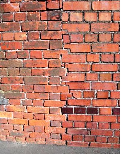
Tasman Street Wall is a brick retaining wall that extends 250 metres south from the rear wall of the Mount Cook Police Station on the corner of Tasman and Buckle Streets. It forms the boundary of the western side of Tasman Street, while houses and apartment buildings occupy the eastern side. Tasman Street in general remains a residential street. A short distance to the west are the various buildings and structures that make up the National War Memorial and the former National Museum (now Massey University). To the south-west, behind the university, is Wellington High School. The wall sits near the northern margins of the suburb of Mt Cook, an inner-city suburb that gets its name form the landmark hill. The wall is a gravity (retaining) wall i.e. its sheer mass and dimensions are used to retain the earth behind. The width of the wall is not known but it is assumed to be substantial - wider at the bottom than the top. A clue may be found in the profile of the retaining wall on the western side of the Mt Cook Police Station (Appendix 2, Figure 23). A photograph taken in 1926, which shows how steep the bank behind once was, suggests that the wall may have been constructed close to or even hard up against the excavated bank, rather the being built in front of the existing bank and back filled (Appendix 2: Figure 6). The brickwork is English bond with its alternating courses of stretchers or headers, although there are odd, isolated variations (see Appendix 2, Figure10). These courses were laid on a shallow pitch which created a rake, or tilt in the wall. Running the entire length of wall is a brick cornice, which steps down at different intervals in harmony with the topography and the height of the street. The height of the wall at the north end is 3.6 metres, while at the southern end it is 2.05 metres. From north to south, the wall shows evidence of the construction sequence. Of particular interest is the conjunction of the wall and the police station. It is known that the wall was built first, but this is also supported by the visual evidence. There is an untidy joint between the wall and the station wall (see Appendix 2, Figure 9). The latter appears to have been extended to meet the wall further south than the point where the station compound actually ends. The weepholes that span the length of the wall are taller in the earlier construction section than the second. There also is a change in the broad arrow markings on the bricks from being present on both headers and stretchers, and of varying orientation, to being only on the headers and incised horizontally. The major addition (in brick) is the additional retaining laid on top of the wall to retain the northern of the two tennis courts, which sits above its southern neighbour (see Appendix 3, Figure 20). No prison bricks were used in this addition. The major addition (in brick) is the additional retaining laid on top of the wall to retain the northern of the two tennis courts, which sits above its southern neighbour. No prison bricks were used in this addition. Two stairs are cut into the wall. The north stair (steps and walls) is constructed of concrete, built hard up against the bricks (see Appendix 2, Figure 13). The south stairs has brick walls and concrete steps. Two piers a short distance up the stairs have cavities in them that probably once housed the fixings for a gate (see Appendix 2, Figure 17). When the substation was built in 1969, a portion of the prison brick wall was removed and replaced with bricks that face the concrete base on which the substation sits. This brick work was integrated into the surrounding brickwork and is distinctive because, while the rake of the initial wall is echoed, much of it is laid horizontally so each course is stepped back slightly (see Appendix 2, Figure 19). The majority of this alteration is, like the tennis court addition, constructed of bricks that were not prison made. However, a few prison bricks were reused in the cornice. There was also an attempt in this section to mirror the curved corners that are a feature of the surrounds to the steps to the immediate north. The wall terminates abruptly in line with the boundary of the tennis courts and 60 Tasman Street. The return wall here was built of concrete, perhaps at the time of the construction of the tennis courts in 1942 (see Appendix 2, Figure 22 of the registration report).
Tasman Street Wall is a brick retaining wall that extends 250 metres south from the rear wall of the Mount Cook Police Station on the corner of Tasman and Buckle Streets. It forms the boundary of the western side of Tasman Street, while houses and apartment buildings occupy the eastern side. Tasman Street in general remains a residential street. A short distance to the west are the various buildings and structures that make up the National War Memorial and the former National Museum (now Massey University). To the south-west, behind the university, is Wellington High School. The wall sits near the northern margins of the suburb of Mt Cook, an inner-city suburb that gets its name form the landmark hill. The wall is a gravity (retaining) wall i.e. its sheer mass and dimensions are used to retain the earth behind. The width of the wall is not known but it is assumed to be substantial - wider at the bottom than the top. A clue may be found in the profile of the retaining wall on the western side of the Mt Cook Police Station (Appendix 2, Figure 23). A photograph taken in 1926, which shows how steep the bank behind once was, suggests that the wall may have been constructed close to or even hard up against the excavated bank, rather the being built in front of the existing bank and back filled (Appendix 2: Figure 6). The brickwork is English bond with its alternating courses of stretchers or headers, although there are odd, isolated variations (see Appendix 2, Figure10). These courses were laid on a shallow pitch which created a rake, or tilt in the wall. Running the entire length of wall is a brick cornice, which steps down at different intervals in harmony with the topography and the height of the street. The height of the wall at the north end is 3.6 metres, while at the southern end it is 2.05 metres. From north to south, the wall shows evidence of the construction sequence. Of particular interest is the conjunction of the wall and the police station. It is known that the wall was built first, but this is also supported by the visual evidence. There is an untidy joint between the wall and the station wall (see Appendix 2, Figure 9). The latter appears to have been extended to meet the wall further south than the point where the station compound actually ends. The weepholes that span the length of the wall are taller in the earlier construction section than the second. There also is a change in the broad arrow markings on the bricks from being present on both headers and stretchers, and of varying orientation, to being only on the headers and incised horizontally. The major addition (in brick) is the additional retaining laid on top of the wall to retain the northern of the two tennis courts, which sits above its southern neighbour (see Appendix 3, Figure 20). No prison bricks were used in this addition. The major addition (in brick) is the additional retaining laid on top of the wall to retain the northern of the two tennis courts, which sits above its southern neighbour. No prison bricks were used in this addition. Two stairs are cut into the wall. The north stair (steps and walls) is constructed of concrete, built hard up against the bricks (see Appendix 2, Figure 13). The south stairs has brick walls and concrete steps. Two piers a short distance up the stairs have cavities in them that probably once housed the fixings for a gate (see Appendix 2, Figure 17). When the substation was built in 1969, a portion of the prison brick wall was removed and replaced with bricks that face the concrete base on which the substation sits. This brick work was integrated into the surrounding brickwork and is distinctive because, while the rake of the initial wall is echoed, much of it is laid horizontally so each course is stepped back slightly (see Appendix 2, Figure 19). The majority of this alteration is, like the tennis court addition, constructed of bricks that were not prison made. However, a few prison bricks were reused in the cornice. There was also an attempt in this section to mirror the curved corners that are a feature of the surrounds to the steps to the immediate north. The wall terminates abruptly in line with the boundary of the tennis courts and 60 Tasman Street. The return wall here was built of concrete, perhaps at the time of the construction of the tennis courts in 1942 (see Appendix 2, Figure 22 of the registration report).
Historical and Associated Iwi / Hapū / Whānau
Completion Date
13th May 2008
Report Written By
Michael Kelly / Karen Astwood
Information Sources
Appendices to the Journals of the House of Representatives (AJHR)
Appendices to the Journals of the House of Representatives
Archives New Zealand (Wgtn)
Archives New Zealand (Wellington)
Evening Post
Evening Post, 27 Jun 1919, p.7.
Wises Post Office Directories
Wises Post Office Directories
Land Information New Zealand (LINZ)
Land Information New Zealand
Lawlor, 1959
P Lawlor, Old Wellington Days, Whitcombe and Tombs: Wellington, 1959.
Lundy, 2005
J Lundy, Nine Thousand Bricks a Day - The Hoffmann Kiln and the Brickworks of Palmerston North, Manawatu Branch of the New Zealand Historic Places Trust, with the Higgins Charitable Trust: Palmerston North, 2005.
Mitchell, 1938
G A Mitchell, Building construction, (13th ed.) B.T. Batsford Ltd. for Aberdeen University Press: Aberdeen, 1938.
Neely, 2003
D Neely and J Romanos, The Basin: An Illustrated History of the Basin Reserve, Canterbury University Press: Christchurch, 2003.
New Zealand Historic Places Trust (NZHPT)
New Zealand Historic Places Trust
New Zealand Mail
New Zealand Mail
Thornton, 1982
Geoffrey G. Thornton, New Zealand's Industrial Heritage, A.H. & A.W. Reed, Wellington, 1982
Wellington City Council
Wellington City Council
Other Information
A fully referenced registration report is available from the NZHPT Central Region Office Please note that entry on the New Zealand Heritage List/Rarangi Korero identifies only the heritage values of the property concerned, and should not be construed as advice on the state of the property, or as a comment of its soundness or safety, including in regard to earthquake risk, safety in the event of fire, or insanitary conditions.
Current Usages
Uses: Civic Facilities
Specific Usage: Wall/Fence
Former Usages
General Usage: Civic Facilities
Specific Usage: Wall/Fence
Current Usages
Uses: Civic Facilities
Specific Usage: Wall/Fence
Former Usages
General Usage: Civic Facilities
Specific Usage: Wall/Fence
Location
Related listings
Sign up to hear more
Get the latest heritage news, features and events delivered
straight to your inbox.
