

The wharf was erected in Commercial Bay, which was used by Maori for food gathering and other purposes before European arrival. Following the foundation of colonial Auckland in 1840, reclamation of the bay successively occurred. By the early 1860s, a large timber wharf had been erected to service the town’s growing commercial centre. A timber wharf survived until the early 1900s, when the inadequate nature of Auckland’s harbour facilities caused the AHB to instigate improvements.
In 1903, the AHB employed W.H. Hamer, who was previously Resident Engineer at the Royal Albert Docks in London. Hamer produced a plan for the comprehensive improvement of Auckland’s waterfront incorporating a series of finger wharves. The Ferro-Concrete Company of Australasia, was contracted to erect the first of these in reinforced concrete at the Railway (later Kings) Wharf, and by early 1907 had begun building the new Queens Wharf. The company is reported to have been the first to use the Hennebique method of concrete construction in New Zealand, and simultaneously constructed Auckland’s Grafton Bridge (1907-10) which had the world’s largest single reinforced concrete span when built. From 1909 work at Queens Wharf was carried out by the AHB evidently under Hamer’s supervision, and was completed in 1913.
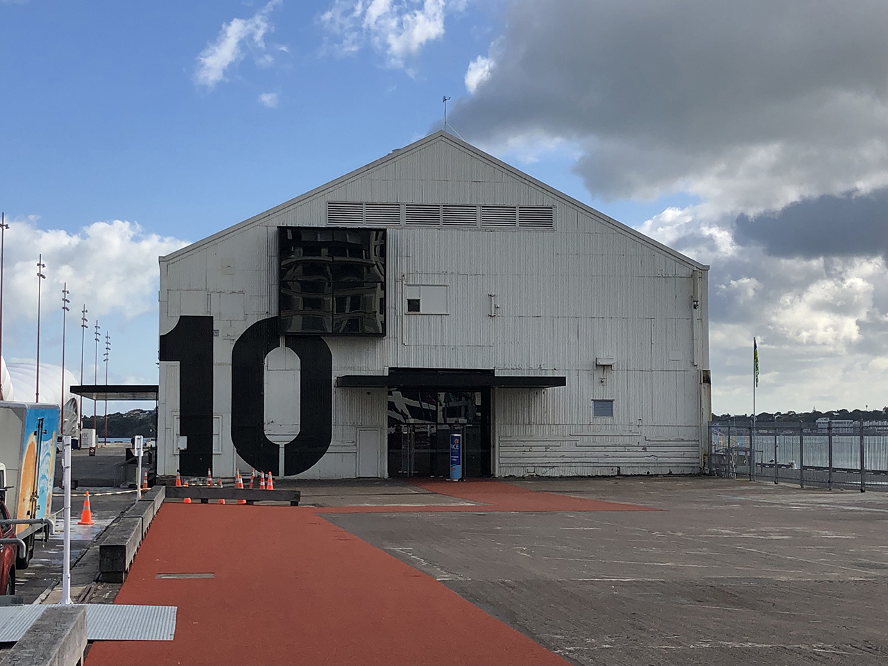
Hamer’s design for the wharf encompassed a central roadway; flanking sheds for the storage of cargo; and railway lines on the opposite side of the sheds beside each quayside. The tracks were connected to the North Island Main Trunk Line via the Auckland Goods Station, enabling direct access between the wharf and Auckland’s extensive rural hinterland. Cargo sheds were of steel-frame construction with corrugated iron cladding, and were initially envisaged to all be double-storey to accommodate transit facilities on the ground floor and warehousing upstairs. The first of these (Shed ‘G’, later known as Shed 15, then Shed 10) was erected on the east side of the wharf in 1910. Single-storey steel-framed structures were built on the west side, including Shed ‘J’ (later known as Shed 18, then Shed 11) in 1914. A Police and Customs Building was constructed near the south end of the wharf in 1911-12.
Before the wharf was fully finished it was used for berthing the HMS New Zealand - a gift from the New Zealand government to the Royal Navy - which was visited by some 94,000 Aucklanders. Towards the end of 1913, the wharf was occupied and barricaded by special constables during the Waterfront strike. The opening of the Panama Canal in 1914 resulted in Auckland becoming the first point of call in New Zealand for ships from Europe and the eastern USA, leading to a further growth in activity. By 1920, Auckland had become the busiest port in New Zealand.
Throughout this period and during the following decades, the wharf remained a central part of the waterfront, housing the Wharf Police and Customs Offices, as well as providing regular ferry services to the North Shore from berths in its southwest corner. It was a venue for ceremonial events, including the departure of troops for the First World War (1914-18), and British royal visits. In 1918, it was linked with controversy over the introduction of the influenza pandemic to New Zealand, which ultimately claimed over 8,000 lives and has been regarded as the country’s worst public health disaster. Many believed that the RMS Niagara was responsible for introducing the virus after it discharged passengers at Queens Wharf without quarantine, although this is no longer considered to be the case.
During the Second World War (1939-45) the wharf operated at full capacity to assist the allied war effort, and was part of the infrastructure that supported the military campaign in the Pacific. At this time, the port was considered to be of ‘vital national importance.’ Facilities were later affected by the 1951 Waterfront Workers Strike, one of New Zealand’s longest and most costly industrial disputes.
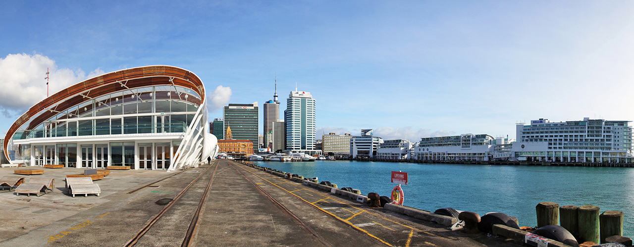
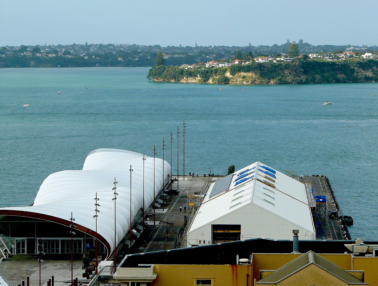
Some changes to the wharf occurred in 1951, but it was with the advent of containerised transport that the biggest alterations occurred. The former Police and Customs building was demolished. Some of the sheds were destroyed or removed. In 2004, a new ferry terminal was built in the southwest part of the wharf, incorporating an early ferry shelter. In 2009, the main part of the wharf was purchased by the government and the Auckland Regional Council. Following a public debate about the fate of two remaining sheds, one (Shed ‘J’, or Shed 11) was dismantled and removed in November 2010, and the other (Shed ‘G’, or Shed 10) retained for ongoing use.
Queens Wharf has historical significance for its close connections with the development of Auckland’s overseas trade during the twentieth century and with organisations and events such as the AHB, the 1913 and 1951 Watersiders strikes, two World Wars and notable ceremonial visits. The wharf has social significance for its central role on the Auckland waterfront; for its function as a major place of arrival to, and departure from New Zealand; and as a place of formal welcome and farewell. It is significant for the perceived consequences of these functions, including during the influenza pandemic of 1918. The place has particularly high technological significance for its connections with early reinforced concrete construction, and may be an early surviving Australasian example of a reinforced concrete wharf. The place has important connections with the pioneering Ferro-Concrete Company of Australasia and its chief engineer R.F. Moore.
List Entry Information
Status
Listed
List Entry Status
Historic Place Category 1
Access
Able to Visit
List Number
9500
Date Entered
10th December 2010
Date of Effect
10th December 2010
City/District Council
Auckland Council
Region
Auckland Council
Extent of List Entry
Extent includes part of the land described as Pt Lot 37 DP 131568, North Auckland Land District, and the buildings and structures known as the Queens Wharf thereon, and their fittings and fixtures. (Refer to map in Appendix 1 of the registration report for further information).
Legal description
Pt Lot 37 DP 131568, North Auckland Land District
Why is this place significant?
Cultural Significance
Social Significance or Value Queens Wharf has social significance for its historical role as a major place of arrival to, and departure from New Zealand. It has particular value as a place of formal welcome and farewell, including for the 3rd Maori Contingent in the First World War, and for British royal visitors. The wharf has social significance as an important place of work on the Auckland waterfront for much of the twentieth century; as the site of notable industrial disputes; and for its connections with other events with a strong social impact such as the 1918 influenza epidemic – New Zealand’s worst public health disaster. It has been part of a local ferry hub since the early twentieth century, allowing Aucklanders access to and from the city centre. Prominently located in the centre of Auckland, the wharf continues to form a notable and familiar backdrop to many people’s daily lives.
Historic Significance
Historical Significance or Value The place has high historical significance for its contribution to the development of trade and commerce in early twentieth-century Auckland. It is of particular value for its connections with the expansion of New Zealand’s overseas trade, including exports from Auckland’s rural hinterland. The place is closely linked with Auckland’s emergence as New Zealand’s busiest and most important port. It has strong connections with police and customs activity, including at a time when the control of imports formed an important part of government management of the economy. Queens Wharf is of particular value for reflecting Auckland’s reliance on maritime transport. This connection extends to the presence of any earlier wharf on the site. It is particularly significant with regard to overseas contact, including mail delivery on the Pacific route and direct links with Europe and the east coast of the USA after the opening of the Panama Canal in 1914. It is also important for its lengthy associations with local ferry travel and the growth of Auckland’s marine suburbs on the North Shore. Queens Wharf has strong connections with the workings of a major Auckland institution, the Auckland Harbour Board (AHB), and in turn Auckland’s mercantile elite. Since 1988, it has been associated with Ports of Auckland Limited, the largest port company in New Zealand. The wharf has notable connections with the Wharf Police and Customs Office, which were housed on the wharf until 1951 and 1973 respectively. Well-known shipping companies to have operated from the wharf include the Peninsular and Orient (P & O), Union Steamship and Cunard lines. The wharf is also significant for its associations with important events in New Zealand’s history. These include the 1913 Waterfront strike; the 1918 flu pandemic; and activities in two World Wars. Ships to have berthed at the wharf include those belonging to New Zealand’s military allies. The place is connected with the remembrance of New Zealand’s contribution in the First World War through the visit by Edward, Prince of Wales in 1920.
Physical Significance
Technological Significance or Value The place has strong technological significance as part of the earliest comprehensive scheme of reinforced concrete wharf construction believed to have occurred in New Zealand. Along with the nearby Ferry Jetty, it is the earliest part of this scheme that is visible. The place demonstrates technology that had been developed by notable French engineers, François Hennebique and Louis Gustave Mouchel. It demonstrates the way in which this system was used in large-scale marine engineering. It is an important surviving work of the pioneering firm, the Ferro-Concrete Company of Australasia, which also erected the Grafton Bridge. The place can be considered significant for reflecting the development of mechanisation within industrial activities, and the use of electricity in port operations.
Why is this place Category 1 / Category 2?
Detail Of Assessed Criteria
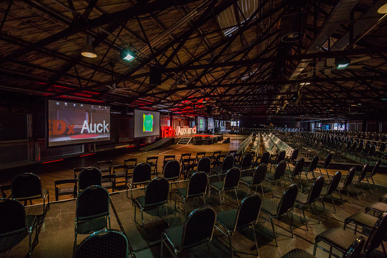
(a) The extent to which the place reflects important or representative aspects of New Zealand history Queens Wharf has special significance for the extent to which it reflects the importance of maritime trade to New Zealand, as one of the main wharves for overseas shipping in this country. It reflects the improvement of port facilities in early twentieth-century Auckland, helping the city to achieve dominance in New Zealand’s maritime trade. It is linked with the expansion of New Zealand’s export production, and increasing productivity in Auckland’s rural hinterland. Its layout and design reflects more systematic approaches to port processes. (b) The association of the place with events, persons, or ideas of importance in New Zealand history Queens Wharf has strong associations with the Auckland Harbour Board (AHB), which held responsibility for Auckland’s waterfront from 1871 and facilitated the city’s emergence as New Zealand’s busiest and most important port during the twentieth century. The AHB was led by notable individuals at the time of the wharf’s construction, including Edwin Mitchelson, who was a former acting Premier and Mayor of Auckland. The wharf was used for almost half a century by the wharf police, and longer by the customs office. Customs inspections in the late 1950s and early 1960s included the grand prix racing cars belonging to Stirling Moss, Bruce McLaren and Jack Brabham. Notable companies that utilised the wharf shortly after its construction included the Peninsular and Oriental (P & O), and Union Company lines. The place has connections with significant events in New Zealand’s history, notably the Waterfront strike of 1913, when the wharf was occupied and barricaded by special constables, and strike-breaking labour was introduced. The wharves were also affected during the 1951 waterfront dispute. Other notable events included visits by the HMS New Zealand in 1913, a vessel gifted to the Royal Navy by the New Zealand government and present in several battles during the First World War. Visits by British royalty similarly demonstrating New Zealand’s close connections with the British Empire in the early twentieth century included those by Edward, Prince of Wales in 1920 and the Duke and Duchess of York in 1927. Other celebrations and related events occurred at the wharf, continuing an earlier tradition of commemoration and welcome at the nineteenth-century wharf on the site. (c)The potential of the place to provide knowledge of New Zealand history The place has the potential to provide knowledge about several aspects of Auckland’s maritime past. It was the site of the settlement’s main wharf from the 1860s until the early 1900s. At least one nineteenth-century shipwreck is recorded beside this wharf. The waterlogged remnants of the early wharf and its associated elements potentially survive within reclaimed land in the southern part of the site, and in silts below the current wharf structure. Remnants may provide evidence about aspects such as trade, or wharf and boat construction. The current structure incorporates extensive remnants of early twentieth-century wharf technology. Elements such as rail tracks, crane rails, mooring bollards and a weighbridge can provide information about work organisation, technological innovation, the growth of mechanisation and related aspects of activity. Structural remnants such as Shed ‘G’ (Shed 10) can provide similar information, and may be particularly valuable due to comparative rarity as a surviving building type. The ferro-concrete structure of the wharf has strong potential to provide knowledge of early reinforced concrete technology and development - notably the Hennebique system and its use in New Zealand. (e) The community association with, or public esteem for, the place The place has considerable community association as a major facility for contact between Aucklanders, and between Auckland and the rest of the world. It has been a place of formal welcome and farewell, including for events of importance to local people. The wharf has been strongly linked with the provision of ferry transport for local inhabitants, including those on the North Shore, for nearly a century. Prominently located in the centre of Auckland, the place continues to be of considerable interest to the general public, as indicated by debates over its future and visitation by several thousand people at an open day in April 2010. (f) The potential of the place for public education The place has considerable potential for public education about New Zealand’s history. This is enhanced by the existence of a large archive of documentary material connected with the wharf, as well as notable surviving physical remains. It is the best-preserved of the early twentieth-century finger wharves along the Auckland waterfront, retaining a number of its early elements. The place - including surviving structures such as Shed G (Shed 10) - has considerable significance as a reminder of the central role of the port and its wharves to Auckland and New Zealand during and beyond the twentieth century. Queens Wharf has particular potential because most of the land is under public ownership; is located in an accessible part of New Zealand’s largest city; and incorporates a major point of embarkation for ferry travel to and from Auckland’s North Shore. It can also present information about an unusually wide range of topics, including the development of trade and technology in New Zealand; Auckland’s emergence as the country’s leading port; and important events such as the 1913 and 1951 Waterside strikes; the 1918 flu pandemic; and the country’s involvement in two World Wars. The potential of the place for public education is enhanced as many of these issues have connections with a diversity of communities, both within New Zealand and in some cases overseas. (g) The technical accomplishment or value, or design of the place The place has outstanding significance for its connections with early reinforced concrete wharf construction in New Zealand. It is an important remnant of what is believed to be the earliest comprehensive scheme of reinforced concrete wharf construction in the country. Reinforced concrete subsequently became a commonplace material in the creation of wharves and jetties around New Zealand’s coastline. Queens Wharf is a well-preserved and early remnant of the Auckland scheme, and also appears to be an early surviving Australasian example. The place has special significance as a major surviving work undertaken by the Ferro-Concrete Company of Australasia and the firm’s Chief Engineer in Auckland, R.F. Moore. Both Moore and the Ferro-Concrete Company can be regarded as being at the forefront of international engineering achievements while work at Queens Wharf was underway. At the time of their involvement, both were also engaged in the design and construction of Grafton Bridge, which had the largest reinforced concrete span in the world when built. Queens Wharf also has value for its design by W.H. Hamer, Engineer to the Auckland Harbour Board (and former Resident Engineer of the Royal Albert Docks). The wharf formed the centrepiece of Hamer’s comprehensive scheme for remodelling Auckland’s waterfront. It may represent an uncommon example of an early twentieth-century finger wharf designed with double rows of cargo sheds and a central roadway. Of the other similarly-arranged finger wharves designed by Hamer in Auckland, the Queens Wharf is the best-preserved. The surviving two-storey structure on Queens Wharf is believed to be the only wharf shed of its type and age to survive on the Auckland waterfront. The structure reflects the integrated nature of the overall wharf design, having taken into account interconnections with road, rail and ship. Its creator, W.H. Hamer, regarded the design to have been carefully considered. It differs in aspects of construction and appearance from early twentieth-century wharf sheds that have so far been identified in other major ports in New Zealand. (k) The extent to which the place forms part of a wider historical and cultural complex or historical and cultural landscape The place has special value as an important component of a notable historical landscape along the Auckland waterfront. The waterfront reflects the extent to which Auckland developed economically in the late nineteenth and early twentieth centuries, ultimately becoming New Zealand’s busiest and most important port. The waterfront is significant as a designed landscape, created as a result of late nineteenth-century reclamation and early twentieth-century port planning. The Queens Wharf is an integral part of the area, having been created as a centrepiece of Hamer’s plan to enhance the city’s port facilities. It survives with other notable elements of its contemporary landscape, including the Ferry Building, the former Chief Post Office, the Queens Wharf Gates and Endeans Building. Many of these lie within the Harbour Historic Area. Summary of Significance or Values This place was assessed against, and found to qualify under the following criteria: a, b, c, e, f, g and k. Conclusion Queens Wharf is considered to qualify as a Category I historic place. Queens Wharf has special value as part of a notable historical landscape along the Auckland waterfront, which reflects how Auckland developed economically in the late nineteenth and early twentieth centuries. The place was the centrepiece of a crucial redevelopment of waterfront facilities in the early twentieth century that ultimately led Auckland to become the busiest and most important port in New Zealand. Queens Wharf is now the best-preserved of the early twentieth-century finger wharves along the Auckland waterfront, visibly retaining structures and features linked with its early use, including the only wharf shed of its type and age to survive on the Auckland waterfront. Queens Wharf has outstanding significance as an important remnant of what is believed to be the earliest comprehensive scheme of reinforced concrete wharf construction in New Zealand. It also has special significance as a major surviving work by the Ferro-Concrete Company of Australasia and the firm’s Chief Engineer in Auckland, R.F. Moore, who were at the forefront of international engineering achievements while work at Queens Wharf was underway. As an important place of embarkation and arrival for passengers, Queens Wharf has particular value for its strong association with key events in New Zealand’s history including the 1913 and 1951 Waterside strikes; the 1918 flu pandemic; and the country’s involvement in two World Wars. The place retains a high profile as a major facility for contact between Aucklanders, and between Auckland and the rest of the world; and is of considerable interest to the general public.
Why is this place significant?
Cultural Significance
Social Significance or Value Queens Wharf has social significance for its historical role as a major place of arrival to, and departure from New Zealand. It has particular value as a place of formal welcome and farewell, including for the 3rd Maori Contingent in the First World War, and for British royal visitors. The wharf has social significance as an important place of work on the Auckland waterfront for much of the twentieth century; as the site of notable industrial disputes; and for its connections with other events with a strong social impact such as the 1918 influenza epidemic – New Zealand’s worst public health disaster. It has been part of a local ferry hub since the early twentieth century, allowing Aucklanders access to and from the city centre. Prominently located in the centre of Auckland, the wharf continues to form a notable and familiar backdrop to many people’s daily lives.
Historic Significance
Historical Significance or Value The place has high historical significance for its contribution to the development of trade and commerce in early twentieth-century Auckland. It is of particular value for its connections with the expansion of New Zealand’s overseas trade, including exports from Auckland’s rural hinterland. The place is closely linked with Auckland’s emergence as New Zealand’s busiest and most important port. It has strong connections with police and customs activity, including at a time when the control of imports formed an important part of government management of the economy. Queens Wharf is of particular value for reflecting Auckland’s reliance on maritime transport. This connection extends to the presence of any earlier wharf on the site. It is particularly significant with regard to overseas contact, including mail delivery on the Pacific route and direct links with Europe and the east coast of the USA after the opening of the Panama Canal in 1914. It is also important for its lengthy associations with local ferry travel and the growth of Auckland’s marine suburbs on the North Shore. Queens Wharf has strong connections with the workings of a major Auckland institution, the Auckland Harbour Board (AHB), and in turn Auckland’s mercantile elite. Since 1988, it has been associated with Ports of Auckland Limited, the largest port company in New Zealand. The wharf has notable connections with the Wharf Police and Customs Office, which were housed on the wharf until 1951 and 1973 respectively. Well-known shipping companies to have operated from the wharf include the Peninsular and Orient (P & O), Union Steamship and Cunard lines. The wharf is also significant for its associations with important events in New Zealand’s history. These include the 1913 Waterfront strike; the 1918 flu pandemic; and activities in two World Wars. Ships to have berthed at the wharf include those belonging to New Zealand’s military allies. The place is connected with the remembrance of New Zealand’s contribution in the First World War through the visit by Edward, Prince of Wales in 1920.
Physical Significance
Technological Significance or Value The place has strong technological significance as part of the earliest comprehensive scheme of reinforced concrete wharf construction believed to have occurred in New Zealand. Along with the nearby Ferry Jetty, it is the earliest part of this scheme that is visible. The place demonstrates technology that had been developed by notable French engineers, François Hennebique and Louis Gustave Mouchel. It demonstrates the way in which this system was used in large-scale marine engineering. It is an important surviving work of the pioneering firm, the Ferro-Concrete Company of Australasia, which also erected the Grafton Bridge. The place can be considered significant for reflecting the development of mechanisation within industrial activities, and the use of electricity in port operations.
Why is this place Category 1 / Category 2?
Detail Of Assessed Criteria
(a) The extent to which the place reflects important or representative aspects of New Zealand history Queens Wharf has special significance for the extent to which it reflects the importance of maritime trade to New Zealand, as one of the main wharves for overseas shipping in this country. It reflects the improvement of port facilities in early twentieth-century Auckland, helping the city to achieve dominance in New Zealand’s maritime trade. It is linked with the expansion of New Zealand’s export production, and increasing productivity in Auckland’s rural hinterland. Its layout and design reflects more systematic approaches to port processes. (b) The association of the place with events, persons, or ideas of importance in New Zealand history Queens Wharf has strong associations with the Auckland Harbour Board (AHB), which held responsibility for Auckland’s waterfront from 1871 and facilitated the city’s emergence as New Zealand’s busiest and most important port during the twentieth century. The AHB was led by notable individuals at the time of the wharf’s construction, including Edwin Mitchelson, who was a former acting Premier and Mayor of Auckland. The wharf was used for almost half a century by the wharf police, and longer by the customs office. Customs inspections in the late 1950s and early 1960s included the grand prix racing cars belonging to Stirling Moss, Bruce McLaren and Jack Brabham. Notable companies that utilised the wharf shortly after its construction included the Peninsular and Oriental (P & O), and Union Company lines. The place has connections with significant events in New Zealand’s history, notably the Waterfront strike of 1913, when the wharf was occupied and barricaded by special constables, and strike-breaking labour was introduced. The wharves were also affected during the 1951 waterfront dispute. Other notable events included visits by the HMS New Zealand in 1913, a vessel gifted to the Royal Navy by the New Zealand government and present in several battles during the First World War. Visits by British royalty similarly demonstrating New Zealand’s close connections with the British Empire in the early twentieth century included those by Edward, Prince of Wales in 1920 and the Duke and Duchess of York in 1927. Other celebrations and related events occurred at the wharf, continuing an earlier tradition of commemoration and welcome at the nineteenth-century wharf on the site. (c)The potential of the place to provide knowledge of New Zealand history The place has the potential to provide knowledge about several aspects of Auckland’s maritime past. It was the site of the settlement’s main wharf from the 1860s until the early 1900s. At least one nineteenth-century shipwreck is recorded beside this wharf. The waterlogged remnants of the early wharf and its associated elements potentially survive within reclaimed land in the southern part of the site, and in silts below the current wharf structure. Remnants may provide evidence about aspects such as trade, or wharf and boat construction. The current structure incorporates extensive remnants of early twentieth-century wharf technology. Elements such as rail tracks, crane rails, mooring bollards and a weighbridge can provide information about work organisation, technological innovation, the growth of mechanisation and related aspects of activity. Structural remnants such as Shed ‘G’ (Shed 10) can provide similar information, and may be particularly valuable due to comparative rarity as a surviving building type. The ferro-concrete structure of the wharf has strong potential to provide knowledge of early reinforced concrete technology and development - notably the Hennebique system and its use in New Zealand. (e) The community association with, or public esteem for, the place The place has considerable community association as a major facility for contact between Aucklanders, and between Auckland and the rest of the world. It has been a place of formal welcome and farewell, including for events of importance to local people. The wharf has been strongly linked with the provision of ferry transport for local inhabitants, including those on the North Shore, for nearly a century. Prominently located in the centre of Auckland, the place continues to be of considerable interest to the general public, as indicated by debates over its future and visitation by several thousand people at an open day in April 2010. (f) The potential of the place for public education The place has considerable potential for public education about New Zealand’s history. This is enhanced by the existence of a large archive of documentary material connected with the wharf, as well as notable surviving physical remains. It is the best-preserved of the early twentieth-century finger wharves along the Auckland waterfront, retaining a number of its early elements. The place - including surviving structures such as Shed G (Shed 10) - has considerable significance as a reminder of the central role of the port and its wharves to Auckland and New Zealand during and beyond the twentieth century. Queens Wharf has particular potential because most of the land is under public ownership; is located in an accessible part of New Zealand’s largest city; and incorporates a major point of embarkation for ferry travel to and from Auckland’s North Shore. It can also present information about an unusually wide range of topics, including the development of trade and technology in New Zealand; Auckland’s emergence as the country’s leading port; and important events such as the 1913 and 1951 Waterside strikes; the 1918 flu pandemic; and the country’s involvement in two World Wars. The potential of the place for public education is enhanced as many of these issues have connections with a diversity of communities, both within New Zealand and in some cases overseas. (g) The technical accomplishment or value, or design of the place The place has outstanding significance for its connections with early reinforced concrete wharf construction in New Zealand. It is an important remnant of what is believed to be the earliest comprehensive scheme of reinforced concrete wharf construction in the country. Reinforced concrete subsequently became a commonplace material in the creation of wharves and jetties around New Zealand’s coastline. Queens Wharf is a well-preserved and early remnant of the Auckland scheme, and also appears to be an early surviving Australasian example. The place has special significance as a major surviving work undertaken by the Ferro-Concrete Company of Australasia and the firm’s Chief Engineer in Auckland, R.F. Moore. Both Moore and the Ferro-Concrete Company can be regarded as being at the forefront of international engineering achievements while work at Queens Wharf was underway. At the time of their involvement, both were also engaged in the design and construction of Grafton Bridge, which had the largest reinforced concrete span in the world when built. Queens Wharf also has value for its design by W.H. Hamer, Engineer to the Auckland Harbour Board (and former Resident Engineer of the Royal Albert Docks). The wharf formed the centrepiece of Hamer’s comprehensive scheme for remodelling Auckland’s waterfront. It may represent an uncommon example of an early twentieth-century finger wharf designed with double rows of cargo sheds and a central roadway. Of the other similarly-arranged finger wharves designed by Hamer in Auckland, the Queens Wharf is the best-preserved. The surviving two-storey structure on Queens Wharf is believed to be the only wharf shed of its type and age to survive on the Auckland waterfront. The structure reflects the integrated nature of the overall wharf design, having taken into account interconnections with road, rail and ship. Its creator, W.H. Hamer, regarded the design to have been carefully considered. It differs in aspects of construction and appearance from early twentieth-century wharf sheds that have so far been identified in other major ports in New Zealand. (k) The extent to which the place forms part of a wider historical and cultural complex or historical and cultural landscape The place has special value as an important component of a notable historical landscape along the Auckland waterfront. The waterfront reflects the extent to which Auckland developed economically in the late nineteenth and early twentieth centuries, ultimately becoming New Zealand’s busiest and most important port. The waterfront is significant as a designed landscape, created as a result of late nineteenth-century reclamation and early twentieth-century port planning. The Queens Wharf is an integral part of the area, having been created as a centrepiece of Hamer’s plan to enhance the city’s port facilities. It survives with other notable elements of its contemporary landscape, including the Ferry Building, the former Chief Post Office, the Queens Wharf Gates and Endeans Building. Many of these lie within the Harbour Historic Area. Summary of Significance or Values This place was assessed against, and found to qualify under the following criteria: a, b, c, e, f, g and k. Conclusion Queens Wharf is considered to qualify as a Category I historic place. Queens Wharf has special value as part of a notable historical landscape along the Auckland waterfront, which reflects how Auckland developed economically in the late nineteenth and early twentieth centuries. The place was the centrepiece of a crucial redevelopment of waterfront facilities in the early twentieth century that ultimately led Auckland to become the busiest and most important port in New Zealand. Queens Wharf is now the best-preserved of the early twentieth-century finger wharves along the Auckland waterfront, visibly retaining structures and features linked with its early use, including the only wharf shed of its type and age to survive on the Auckland waterfront. Queens Wharf has outstanding significance as an important remnant of what is believed to be the earliest comprehensive scheme of reinforced concrete wharf construction in New Zealand. It also has special significance as a major surviving work by the Ferro-Concrete Company of Australasia and the firm’s Chief Engineer in Auckland, R.F. Moore, who were at the forefront of international engineering achievements while work at Queens Wharf was underway. As an important place of embarkation and arrival for passengers, Queens Wharf has particular value for its strong association with key events in New Zealand’s history including the 1913 and 1951 Waterside strikes; the 1918 flu pandemic; and the country’s involvement in two World Wars. The place retains a high profile as a major facility for contact between Aucklanders, and between Auckland and the rest of the world; and is of considerable interest to the general public.
Construction Professional
Name
Hamer, W.H
Type
Engineer
Biography
W.H. Hamer (c.1869-1940) was educated at Rugby, England, and in the mechanical workshops at King’s College. He was subsequently articled to E.G. Mawbey, the waterworks engineer at King’s Lynn, Norfolk, who was also President of the County Engineers and Surveyors’ Association. By the early 1900s, Hamer occupied the post of Resident Engineer of the Victoria and Albert Docks in London, said at the time to be ‘unsurpassed in the completeness of its arrangements by any other docks in the world.’ Employed by the London and India Dock Company during this period, Hamer worked in a department with an expenditure of more than £200,000 and was in charge of over a thousand workmen. In January 1903, Hamer was appointed Engineer to the Auckland Harbour Board and arrived in New Zealand a few months later. In July 1904, he produced his blueprint for the modernisation of Auckland’s port facilities, involving a radical reorganisation of the waterfront using innovative aspects such as ferro-concrete wharves. Work was undertaken on the Railway (later Kings) Wharf extension in 1904-8, the Ferry Jetty in 1907, and the Queens Wharf in 1907-13, although it was not until the 1920s that some elements of his scheme such as the Princes Wharf (1921-4) were completed. Hamer is said to have overseen construction of parts of the Queens Wharf himself. Hamer’s opinion was evidently sought for other harbour-related projects including at Thames and Whakatane. In 1907, he also produced a set of plans for a canal between the Waitemata and Manukau harbours, although this was never built. Keeping up-to-date with methods of wharf construction and new machinery, he undertook tours of inquiry to Australia (1914), Canada and the United States (1918), and the ports of Great Britain (1920). Hamer resigned from his post with the Auckland Harbour Board in December 1924. Source: Registration Report for First World War Memorial (Register No. 9652), May 2014
Name
Ferro-Concrete Company of Australasia Ltd.
Type
Builder
Biography
The Ferro-Concrete Company of Australasia was an Australian-based business, which operated mainly in New Zealand. Its parent company was evidently L.G. Mouchel (later L.G. Mouchel & Partners), founded by a major populariser of reinforced concrete in Britain, Louis Gustave Mouchel (1852-1908). Specialising in reinforced concrete construction, the Ferro-Concrete Company held the licence in New Zealand and Australia to patents granted to Mouchel. Both Mouchel and the Ferro-Concrete Company were closely linked with methods developed by fellow French engineer François Hennebique. In 1897, Mouchel erected what is regarded as the first reinforced concrete framed building in Britain - Weaver’s Granary and Flour Mill in Swansea - to Hennebique’s design. The Ferro-Concrete Company was evidently operating in Australia in 1902. It is reported to have been the first to undertake the construction of reinforced structures in New Zealand under the Hennebique system. The company was responsible for initial large-scale modernisation of Auckland’s waterfront in the early 1900s, including the Railway (later Kings) Wharf extension (1904-8), the Ferry Jetty (1907) and an initial portion of the Queens Wharf (1907-9). It erected other works in the same city including Liechtenstein’s Building and a store for the Northern Roller Mills (1907-8), as well as structures in Napier, Hastings, and Wellington. It also built what was regarded as the first ferro-concrete wharf in Queensland at Gladstone (1907-8), and reinforced concrete wharves at Nukualofa (c.1906-7) and Neiafu (1908) in Tonga. The company is perhaps most notable for the design and initial construction of Grafton Bridge, Auckland, at that time the largest single-span reinforced concrete structure in the world. The company, however, went into liquidation in November 1909. Some of the works that it was engaged in, such as Grafton Bridge, were taken over by other bodies. By December 1910, it had completed all of its contracts other than one that was sub-contracted. The company’s final meeting of shareholders occurred in 1911.
Name
Moore, Robert Forbes
Type
Engineer
Biography
Robert Forbes Moore (c.1865 -1938) was born in South America and educated in England, later joining the Royal Engineers. After moving to Australia, he became involved in mining engineering. In the early 1900s he was employed by the Ferro-Concrete Company of Australasia, becoming its engineer-in-chief based in Auckland. While in this position, Moore was responsible for overseeing the company’s construction of extensive works along Auckland’s waterfront, including the Railway (later King’s) Wharf extension in 1904-8, the Ferry Jetty in 1907, and early parts of the Queens Wharf in 1907-9. He also oversaw the construction of early reinforced concrete buildings in Auckland such as the Northern Roller Mills building (1907-8), and a breakwater extension and new wharf for the Napier Harbour Board (c. 1906). Prior to the liquidation of the Ferro-Concrete Company in 1909, Moore was also responsible for the design and initial construction of the Grafton Bridge, Auckland, which had the largest reinforced concrete span in the world when built. He later oversaw construction of the first Mangere Bridge, built in reinforced concrete in 1914-15, and undertook other work in the Auckland region. He died in Auckland in 1938, aged 73.
Construction Details
Start Year
2012
Finish Year
2013
Type
Refurbishment/renovation
Description
Refurbishment of Shed 10
Type
Original Construction
Description
Timber wharf erected
Period
Pre 1984
Type
Addition
Description
Additional tees constructed
Period
1870s
Type
Addition
Description
Further tees added
Period
1880s
Start Year
1904
Type
Designed
Description
New wharf designed
Start Year
1907
Type
Original Construction
Description
Construction of ferro-concrete Queens Wharf underway
Start Year
1907
Finish Year
1913
Type
Demolished - Other
Description
Gradual removal of earlier wharf
Start Year
1910
Type
Original Construction
Description
Construction of Shed ‘F’ (later known as Shed 14), and Shed ‘G’ (later known as Shed 15, then Shed 10)
Start Year
1911
Type
Original Construction
Description
Weighbridge
Start Year
1911
Finish Year
1912
Type
Original Construction
Description
Construction of Police and Customs Building
Start Year
1912
Finish Year
1913
Type
Original Construction
Description
Construction of Shed ‘H’ (later known as Shed 16)
Start Year
1913
Type
Other
Description
Completion of Queens Wharf superstructure
Start Year
1913
Finish Year
1914
Type
Original Construction
Description
Construction of Shed ‘I’ (later known as Shed 17)
Start Year
1913
Finish Year
1914
Type
Original Construction
Description
Construction of gates and fence
Start Year
1914
Type
Original Construction
Description
Construction of Shed ‘J’ (later known as Shed 18, then Shed 11) and ferry shelter. Additional chutes inserted in Shed ‘G’ (Shed 10)
Start Year
1920
Type
Other
Description
Fruit Inspector’s office in Shed ‘G’ (Shed 10) dismantled. Cargo platform for upper floor added
Start Year
1925
Type
Modification
Description
Corrugated iron roof of Shed ‘G’ (Shed 10) replaced by corrugated asbestos cement
Start Year
1927
Type
Modification
Description
Balcony of Shed ‘G’ (Shed 10) renewed in Brushbox timber
Start Year
1928
Type
Modification
Description
Repairs to concrete wharf. Customs Offices on upper floor of Shed ‘G’ (Shed 10) renovated and painted
Start Year
1932
Type
Addition
Description
Addition of raker piles to wharf
Start Year
1934
Type
Other
Description
Alterations to lifting mechanism for roller shutters in Shed ‘G’ (Shed 10)
Start Year
1935
Type
Other
Description
Alterations and additions to Customs Offices in Shed ‘G’ (Shed 10)
Start Year
1939
Type
Other
Description
Asphalt surface replaced by durable metal concrete
Type
Modification
Description
Roof of Shed ‘G’ clad with RPM sheeting
Period
1950s
Start Year
1952
Type
Original Construction
Description
Electricity substation building constructed
Start Year
1970
startYearCirca
Type
Demolished - Other
Description
Police Building demolished 1970s
Start Year
1983
Type
Addition
Description
Substation addition erected
Type
Other
Description
Removal of Sheds ‘F’, ‘H’ and ‘I’
Period
Pre 2001
Start Year
2004
Type
Original Construction
Description
Construction of ferry terminal building, incorporating retention and conservation of earlier ferry shelter
Start Year
2010
Type
Other
Description
Dismantling of Shed ‘J’ (Shed 11)
Construction Materials
Queens Wharf: reinforced concrete Shed ‘G’ (Shed 10): steel frame, with corrugated iron wall cladding, corrugated asbestos roof cladding; and timber upper floor and partitions Ferry shelter: timber with corrugated metal roof
Early history of the site Prior to European colonisation, Maori occupied numerous sites beside the Waitemata Harbour and used its associated bays for transport, food-gathering and other purposes. The bay which now borders Auckland’s commercial centre was linked with settlement in the Waihorotiu Valley and its adjoining headlands, which has been traditionally connected with Ngati Haurere, Te Waiohua and Ngati Whatua. The bay contained a pipi bank known as Te Roukai. Following the initial foundation of colonial Auckland in 1840, the waters between Point Britomart and Smales Point were renamed Commercial Bay. The bay formed the new settlement’s main harbour, and its key landing point for goods and settlers. Arrivals during the first few years were made directly on to the foreshore or a rocky ridge extending into its waters. Jetties were subsequently erected, including a structure at the northern end of Queen Street, which serviced the town’s emerging commercial centre in the Waihorotiu or Queen Street valley. In 1852 a new Queen Street wharf was erected, evidently using Maori labour for at least some aspects of the work. Located within the bay’s main deep water channel, the wharf allowed large boats used for long-distance travel to access the shore. Throughout the rest of the nineteenth century, a wharf at the end of Queen Street remained a major economic lifeline for Auckland, and an important means of communication with the outside world. When initial reclamation of the bay was carried out as far north as Custom House (now Customs) Street during the late 1850s and early 1860s, a long timber wharf with projecting berthing tees was constructed, which is said to have measured 1,555 feet long by 40 feet wide. It remained Auckland’s main wharf even after further reclamation in the 1870s and 1880s extended the harbourfront to its current location on Quay Street, and allowed the creation of supplementary berthage at the new Railway Wharf to the east and elsewhere. A report in 1871 noted that the Queens Wharf had three tees, and further tees were added in the 1870s and 1880s. Images of the Queens Wharf in the late nineteenth century show it as a place where bustling mercantile activity and social functions such as promenading mingled. Redevelopment of the Auckland Waterfront (1904 onwards) In 1886, Auckland became New Zealand’s most populous city, and its growth placed increasing strain on the port’s facilities. Along with Wellington, Lyttelton-Christchurch and Dunedin-Port Chalmers, Auckland was one of the ‘big four’ centres for the country’s shipping trade. A rapid increase in trading activity after the depression of the late 1880s and early 1890s caused the authorities and leading merchants to consider further improvements to the port. In 1900, it was stated that ‘to meet the growing trade of the port, further accommodation will soon be absolutely necessary.’ Responsibility for the port lay with the Auckland Harbour Board (AHB), which had been founded in 1871. The AHB oversaw a large area extending from the Tamaki River located to the south of Auckland city, to Rangitoto and the North Shore further north. Traditionally, the organisation was dominated by members with strong mercantile connections. Its board was made up of individuals that were appointed or elected by the government, city council, adjoining Highway Boards, the Chamber of Commerce, and the payers of Harbour dues. The AHB sought to appoint an engineer to prepare plans and oversee works. In January 1903, it recruited W.H. Hamer (c.1869-?) following the resignation of an earlier appointee. A comparatively young man, Hamer had previously occupied the important role of Resident Engineer of the London and India Dock Company, based at the Royal Victoria and Albert Docks in London. While under his care, the Albert Docks were described as ‘unsurpassed in the completeness of its arrangements by any other docks in the world’: they were the first in London to be lit by electricity so as to allow operations to occur day and night, and were specifically intended to be used for goods in transit. To this end, they included a network of single-storey transit sheds considered unique when the docks opened in 1880, and also incorporated rail access for the efficient transfer and distribution of goods. Shortly after his arrival in Auckland, Hamer was asked to provide a comprehensive scheme for the modernisation of the waterfront. His report, produced in June 1904, recommended a scheme stretching from Freemans Bay in the west to Mechanics Bay in the east, involving the construction of a network of reinforced concrete finger wharves at right angles or inclined from the Quay Street frontage. Wharves in the western and eastern parts of the scheme were to be erected in conjunction with an extensive reclamation programme. All were to incorporate large sheds on either side of a broad roadway for vehicle access, with railways to be situated between the sheds and the main quay sides. Electrical lifting machinery was recommended for loading and discharging cargo from vessels. Many aspects of Hamer’s scheme were innovative and forward-looking. Its systematic and technologically-advanced approach to the rapid transfer of large cargo loads foresaw the future growth of Auckland’s trading requirements and the increasing size of overseas shipping. The suggested use of reinforced concrete was also at the forefront of technological developments in New Zealand and the broader region. Reinforced concrete was particularly useful for wharf construction due to its potential durability and resistance to pests. Although reinforced concrete had been invented in 1849, it was not until the 1890s that its use for piles, beams and floors was pioneered in France by François Hennebique (1842-1921). Patents for Hennebique’s system and modifications by Louis Gustave Mouchel (1852-1908) were licensed in Britain in the late 1890s, and applied at an early stage for the construction of port structures. Possibly the earliest was a jetty erected for the Irish cattle trade at Liverpool in 1895-7, although a wharf at Southampton in 1899 has been described as the first structure of any magnitude. As the main populariser of Hennebique’s methods in Britain, Mouchel had supervised the country’s first reinforced concrete fully-framed structure and also undertook work for Hamer’s previous employers at the Royal Albert Docks. Hamer had evidently attempted to contact Mouchel before leaving London, to ask if he would carry out work in New Zealand. Hamer’s scheme was formally adopted in August 1904, and permission sought to obtain a loan of £400,000 to carry out an initial part of the plan. Members of the board who approved the scheme included the future chairman Edwin Mitchelson (1846-1934), who was a former Minister of Public Works and acting Premier, as well as being a prominent timber merchant, and Mayor of Auckland in 1903-5. The agreement to use reinforced concrete appears to have pre-dated other comparable developments in New Zealand, including the construction of reinforced concrete wharves at Napier (circa 1906 and 1908-9); Limestone Island, Whangarei (circa 1906-8); the Ferry Street wharf in Dunedin (1907); and Clyde Quay Wharf in Wellington (1909-10). In Australia, the earliest concrete wharves in Queensland and South Australia are respectively said to have been erected at Gladstone (1908) and Port Adelaide (1908-9). Elsewhere, works at Singapore were reportedly underway in 1904, while in another British imperial port at Madras, India, more than 1400 metres of wharfing using pre-cast piles and retaining walls was undertaken in 1905-10. Early twentieth-century reporters believed that Auckland was the first place in New Zealand to use reinforced concrete in the construction of a wharf. In 1913, a newspaper account further claimed that ‘the Auckland Harbour Board was the first in the Southern Hemisphere to adopt the system of ferro-concrete construction on an extensive scale’. Construction of Queens Wharf (1907-1913) The first tests for concrete piles on the Auckland waterfront were carried out in November 1904. By February 1905, a contract for the first part of the waterfront scheme - consisting of a major extension to the pre-existing Railway Wharf - was said to be in hand. Visitors to the works included the Minister for Agriculture in Victoria, Mr Swinburne, who subsequently declared that he had become a ‘thoroughgoing ferro-concretist’ and that from his perspective no more wooden piles would be used for harbour works in Victoria. The second stage of the project was to involve the replacement of the pre-existing Queen Street wharf with a much wider finger wharf, and the construction of a small ferry jetty a short distance to the west. The Queen Street wharf was to incorporate deep-water berths so that ‘the largest vessel afloat could berth at the foot of Queen Street’. Ferry traffic was also to be accommodated at an angle on its western side, ‘bringing both services to one centre and under one control at the foot of Queen Street’. The wharf was ultimately to house most of the official functions necessary for the practical operation of the waterfront, including customs, police and harbourmaster facilities. Plans for the new wharf were prepared and submitted to the Board in November 1904. In late 1905, the AHB sought tenders internationally for the construction of part of the new Queens Wharf and the Ferry Jetty. The contract was initially awarded to the Ferro-Concrete Company of Australasia, although it was not the lowest bidder. Controversy over this award caused fresh tenders to be called, after which the Ferro-Concrete Company was again offered the contract in spite of not being the least expensive. Reasons given by the Board for preferring the company included the strength of the structure provided for. The firm had also already started erecting the Railway Wharf extension for the AHB. The Ferro-Concrete Company was an Australian-based enterprise, which held the patents granted to Mouchel and others in New Zealand and Australia. Specialising in reinforced concrete construction, the company is reported to have been the first to undertake the construction of structures in New Zealand under the Hennebique system. The firm’s chief engineer in Auckland was W.F. Moore, who later designed the Grafton Bridge, which had the world’s largest single reinforced concrete span when built (1907-10). Apart from its work on the Railway Wharf and Grafton Bridge, the company created other notable structures including the concrete wharf at Napier (circa 1906); the first reinforced concrete wharf in Queensland (Gladstone, 1907-8); and reinforced concrete wharves in Tonga (Nukualofa, c.1906-7; and Neiafu, 1908). Because of the need to keep the Queens Wharf in use during the construction process, the new structure was erected in several stages. Initially, concrete piles were driven to the east of the pre-existing wharf, to support a temporary roadway to the inner tees. Work appears to have commenced by the beginning of 1907, when Hamer noted that the temporary approach would soon be available. By June 1907, this structure was in use and the timber decking of the southern part of the earlier wharf was being removed. The separate ferry jetty to the west had also been completed. By the middle of the following year, the permanent replacement of the southern part of the earlier wharf had been finished, and the temporary approach closed. Replacement of the central part of the wharf appears to have been finished by September 1909, marking the end of the contract between the Ferro-Concrete Company and the AHB. The company went into liquidation at this time, in spite of its involvement in several major projects. The superstructure on the site of the former approach was subsequently erected by day labour employed by the AHB, and evidently overseen by Hamer. This was completed in 1910, after which work on the northeast part of the wharf was undertaken. Concrete piles for this element were made in Freemans Bay, but due to factors including a lack of trained workmen this section was not completed until 1912. Approximately seven miles of piles had been used by this stage, with some measuring 100 feet long by 20 inches square, and weighing twenty tons. The final section on the northwest side was completed in 1912-13. The last pile was driven on 14 October 1913. Construction methods may have been modified as work progressed. In 1909, it was reported that the piles used by Hamer contained as many as twelve steel rods, while those previously employed by the Ferro-Concrete employed only four. Materials appear to have come from both local and overseas sources. Initial reinforcement steel arrived from England. However, cement was supplied by Wilsons Portland Cement Company and the Whangarei-based New Zealand Portland Cement Company. Local companies J.J. Craig and Winstone Ltd. also provided sand and shingle. Timber piles from the earlier wharf were spliced and re-used as fenders on the eastern side of the new structure. Construction of cargo sheds and other structures The Queens Wharf incorporated facilities for transport by road, rail and sea. Its spatial design may have been unusual in a New Zealand context. In Hamer’s initial scheme, five double-storey sheds were to be erected in which to store cargo: three on the east side of the wharf and two on the west. These were to be positioned on either side of a broad central thoroughfare to allow the easy transfer of goods between the sheds and road vehicles. Railway tracks along the quaysides were to facilitate the transfer of cargo between the sheds and rail network, as well as directly between rail and ship. The tracks were to be connected to the North Island Main Trunk line via Auckland’s Goods Station, allowing the distribution of cargo to and from an extensive rural hinterland. The expansion of shed facilities on the waterfront was an important part of Hamer’s scheme. Large and conveniently located sheds enabled ships to be loaded and unloaded more rapidly, particularly if associated with mechanised transfer. Although most sheds in Hamer’s overall scheme were to be of single-storey design, double-storey structures were proposed for the Queen Street and Hobson Street wharves to accommodate transit goods at ground floor level, and longer-term warehousing for merchants on the upper floors. Hamer suggested that rental from the latter would pay the interest on money borrowed for the scheme. Cargo could be delivered to the top floors by crane, and transferred by chutes or other appliances to the lower storey or vehicles as required. Buildings and ancillary features were erected as wharf construction progressed. Designs for double-storey cargo sheds on Queens Wharf were well-advanced by January 1908, when Hamer noted that: As these structures have no precedent in the Port, every minute detail has to be carefully designed and considered... In order to make the most satisfactory and economical work, and at the same time make all sheds available for the interchange of machinery, such as cranes, lifts, elevators etc., prolonged and careful investigation of items quite outside the mere sheds themselves has to be made. By June 1909, a contract had been let for the first two structures. Initially known as Sheds ‘F’ and ‘G’, these were to be erected on the eastern side of the wharf. The contract was awarded to J.H. Adams and Co., a local engineering firm that had previously been engaged to erect smaller structures on the Railway Wharf. The initial cost of the sheds was £33,829, a considerable amount. Shed ‘G’ (later known as Shed 15 and then Shed 10: still surviving) appears to have been the first to be erected, shortly followed by Shed ‘F’ (later known as Shed 14) to the south. Work was underway by March 1910, and anticipated for completion before the end of the year. Each shed was rectangular in plan, measuring 320 x 80 feet, and of steel-framed construction with substantial timber flooring at upper-storey level. They were clad with corrugated iron, and incorporated large openings in their roadside elevations that were sealed by roller shutters. The latter were delivered in 1911, when electric lifts and an overhead traveller were also installed. Wider than sheds on the Railway Wharf, the buildings contained large open spaces and were reportedly regarded as ‘favourite working areas’. They included a waterside workers’ room on the upper storey of Shed ‘F’, an electrical switchboard room, and accommodation for Customs and Traffic Managers’ Offices. Subsequent structures included a Police and Customs Building (1911-12) of wedge-shaped design located in the southwest part of the wharf, and another double-storey shed, ‘H’ (1912-13, later known as Shed 14), to the north of Shed ‘G’. Two further cargo sheds, ‘I’ (1913-14, later known as Shed 17) and ‘J’ (1914; later known as Shed 18, and then Shed 11), were erected on the western side of the wharf as single- rather than double-storey steel-framed structures, although they were to be made strong enough to accommodate an additional storey at a future date. Hamer had previously indicated that the efficiency in transferring cargo exhibited by the new system was ‘a source of considerable revenue to merchants but a loss on storage to the Board’. The combined cost of structures ‘I’ and ‘J’ was £17,229 and, as with the other sheds, they were erected by J.H. Adams. Related elements for the functioning of the wharf included a weighbridge and electric lighting (installed by 1911); an improved water supply; and four five-ton electric cranes and four one-ton electric capstans (ordered by January 1912). Following installation, the cranes travelled along rails that were located close to the wharf edge on one side and attached to the cargo sheds on the other, enabling cargo to be lifted into the upper floor of the two-storey buildings via a projecting platform and large sliding doors at first floor level. Timber chutes for transferring goods from the upper to ground floor areas inside these buildings were soon increased in number. The wharf was progressively asphalted by the Neuchatel Asphalte Co. to create a smooth working surface. Initial use of Queens Wharf The primary function of the Queens Wharf was to facilitate overseas trade. However, it also received passenger ships and was frequently the scene for welcomes, farewells and other activities. Before the new berths were ready, one of the first two sheds was employed as a venue for the Agricultural and Pastoral Winter Show in 1910, accommodating crowds of people and a large display of exhibits. In June 1911, Shed ‘F’ was utilised for concerts by the 200-strong Sheffield Choir as part of the Music Festival of the British Empire. Initial ships at the new berths included mail steamers from the Peninsular and Oriental (P & O), and Union Company lines. The P & O had recently extended its England-Australia passenger service to Auckland, and in 1911 the Union Company - which had a near monopoly on the Pacific mail routes pertaining to New Zealand - made Auckland rather than Wellington its port of call. The first vessel to use Shed ‘H’, in April 1913, was the SS Zealandia which worked the Pacific mail route. The proximity of the wharf to the new Chief Post Office (1909-12) in Queen Street may have been significant, as the latter contained substantial mail facilities that were also linked to the railway system. Other new construction was linked with the wharf. In 1909-12 the Ferry Building was erected, immediately adjoining the inner berths on Queens Wharf that serviced an extensive ferry network in the Waitemata harbour. In 1913, 94,000 Aucklanders visited the battleship HMS New Zealand which berthed at the Queens Wharf. At the time, Auckland’s population was approximately 113,000. The ship was presented to the British Royal Navy by the New Zealand government, following the country’s emergence as a Dominion in 1907. The HMS New Zealand went on to participate in several notable battles in the First World War (1914-18), including Heligoland, Dogger Bank and Jutland. Shortly before the wharf was fully completed, the 1913 Waterfront Strike broke out, paralysing port facilities at Wellington, Auckland and elsewhere. A supporting general strike in Auckland was the first in New Zealand’s history, and involved more than 10,000 workers including most of the AHB’s employees. The authorities took charge of the waterfront using special constables recruited from the farming community, who reportedly erected a barricade across the entrance of the Queens Wharf employing timber piles that were ‘plentiful around the waterfront in consequence of the reconstruction in ferro-concrete’. Sleeping quarters were prepared for 400 ‘specials’ in the upper storey of Shed ‘F’. Rural strike-breakers were also escorted to the site to unload shipping, and were initially accommodated in a shed at ‘the outer end of the Queen’s Wharf’. Such actions helped to undermine the effects of the strike, which was subsequently called off. Greater ability to control access to the wharf was foreseen with the letting of a contract for an ornamental fence and gates in November 1912. The need for gates was said to be demonstrated a few months later, when a crowd of several thousand people who arrived to witness the berthing of the Sydney steamer, Wimmera, made it difficult for passengers to leave the wharf. The fence and gates were erected in 1913-14. After their creation, public entry was restricted during the arrival and departure of large vessels, although admission could be gained by paying 2d. A shelter for the ferry jetties in the southwest corner of the wharf appears to have been erected in 1914. Completion of the wharf and its associated structures in 1914 broadly coincided with the opening of the Panama Canal, a major factor in enabling Auckland to surpass the South Island ports in importance, and ultimately also Wellington. The port now became the first place of call in New Zealand for ships from both the eastern USA and Great Britain. Completion of the North Island Main Trunk Line in 1908 also stimulated growth, as did the development of Auckland’s rural hinterland. Although Auckland was noted for its imports, it also exported large quantities of produce including butter, cheese and frozen meat, and extractive products such as timber, gold and kauri gum. By 1920, Auckland had become the busiest port in New Zealand, with more overseas and coastal vessels calling than at any other centre. Subsequent history The wharf remained the port’s centre of operations for several decades. It was a busy and sometimes hazardous workplace, perhaps reflected in its choice as the location for safety facilities such as a motor ambulance provided by the Waterside Workers’ Union, and a casualty room fitted with first aid appliances. In the 1930s, all discharging, trucking, and stacking of cargo in sheds was carried out by shipping companies or stevedoring firms acting for these firms. At this time, the wharf accommodated HM Customs, the Water Police, the shipping companies and receiving firms. The separately enclosed part of the wharf reserved for local ferries, such as those run by the Devonport Steam Ferry Company, provided a regular service to suburbs on the North Shore as these settlements expanded. In spite of restricted access, the main part of the wharf remained socially important as a place where an earlier tradition of public welcome, send off and commemoration was maintained, and where many people had their first, or last, experience of New Zealand. In 1916, several thousand troops belonging to the 4th Battalion of the New Zealand Rifle Brigade, the 3rd Maori Contingent, and two sections of the No.2 Rifle Brigade Ambulance paraded through the city before setting off from Queens Wharf to fight in the First World War (1914-18). The men were addressed under cover of the large sheds at the wharf by a number of dignitaries, including the Governor, the Prime Minister, the Minister of Defence and others. Later in the war, armed guards protected the wharf. Advertised instructions relating to returning troopships stipulated that arrival would occur only at guarded wharves, and that friends and relatives would be required to wait in a reserved enclosure rather than alongside the ship as previously. Returning troops included those from the Maori Pioneer Battalion, who disembarked from the Westmoreland in April 1919, and were ‘greeted by the greatest enthusiasm and cheered to the Domain’ for a formal welcome. The group was the only battalion of the New Zealand Expeditionary Force to return to New Zealand as a complete unit, and consequently received a particularly enthusiastic reception. At the end of the war, the wharf was linked with controversy over the introduction of the influenza pandemic to New Zealand, which accompanied the return of overseas troops. The pandemic ultimately claimed over 8,000 lives and has been regarded as the country’s worst public health disaster. In October 1918, the RMS Niagara was allowed by the Minster of Health, George Russell (1854-1937) to discharge its passengers at Queens Wharf without quarantine, in spite of an influenza outbreak onboard that had claimed the life of a crew member. Many at the time believed that the ship was responsible for introducing the virus, although this is no longer considered to be the case. Passengers included the Prime Minister William Massey (1856-1925) and his deputy (and former Prime Minister) Sir Joseph Ward, who were returning from the Imperial War Conference in London. In 1920 Edward, Prince of Wales, disembarked at the wharf to formally thank the Dominion for its involvement in the war effort, and to participate in Anzac Day commemorations. He was received in one of the cargo sheds by the Governor-General Lord Liverpool, the Prime Minister William Massey and others. A boxing tournament organised by the Northern Boxing Association was held in Shed ‘G’ (Shed 10) during the visit, involving some of the crew from the prince’s ship, the HMS Renown. In 1927, the Duke and Duchess of York were welcomed at the wharf, where a dais was erected. Other celebrations or worthy causes were marked by illuminations or the erection of bunting. Early modifications to the wharf structures around this period included adding cargo platforms to the upper floors of the two-storey sheds, and dismantling a Fruit Inspector’s Office in Shed ‘G’ in 1920. Roof claddings for all sheds were initially treated with tar and then replaced due to the effects of the marine environment. When Princes Wharf was constructed in 1921-4, its cargo sheds were erected of a different style and in concrete. In 1932, the Queens Wharf structure was strengthened with the addition of raker piles. The replacement of the wharf’s asphalt surface with vibrated metal concrete was begun in 1939. Proposals to extend the wharf to accommodate greater passenger and mail traffic did not eventuate. Following the outbreak of the Second World War (1939-45), the port was considered to be of ‘vital national importance.’ Food production was expanded to supply Britain and later American troops in the Pacific as part of the war effort. Numerous troopships departed from Auckland bearing members of the New Zealand Expeditionary Force. Defensive measures for the wharf included a proposed Bofors gun on top of the adjacent Endeans Building, and an air raid shelter with accommodation for 33 staff. In 1942, the Cabinet approved the dredging of the west side of Queens Wharf and other berths along the waterfront, during preparations for potential use of the harbour by the American Fleet. Early US troopships to visit included the Uruguay and Santa Paula, one of which docked at Queens Wharf. From June 1942 to 1945, Auckland played a notable role as a major operating and supply base for American forces in the South Pacific campaign, and was initially home of the US South Pacific Command (COMSOPAC). At least 1.5 million tons of cargo was handled for the US Forces during this period, in addition to the usual port business. To cope with the volume, the wharves operated around the clock for seven days a week, and new equipment such as tractors and trailers was introduced. A significant part of the immediate hinterland was linked with associated activities such as housing, storage and production for the military effort. Queens Wharf lay close to the heart of the American operation, which was based at Princes Wharf. Following the war, other events to affect the port included the 1951 Waterfront Workers Strike, one of New Zealand’s longest and most costly industrial disputes. In February the wharves were taken over by the military, and an ensuing lockout lasted some 151 days. The wharf police moved from the Queens Wharf to new premises in the same year. In April 1952, a contract was issued for the construction of a small Auckland Electric Power Board substation just inside the entrance to the wharf - one of a pair that also included a building at the entrance of Princes Wharf (since demolished). The substation subsequently provided electricity to the wharf via one of the cargo sheds, as well as to the Ferry Building and breastwork between the Queens Wharf and Captain Cook Wharf. In 1954, the AHB determined that all cargo sheds on the waterfront should be provided with improved lighting in the form of fluorescent rather than filament lights. Other changes are likely to have occurred following the creation of the overseas passenger wharf on Princes Wharf in 1961 and the advent of more widespread air travel. Between 1940 and 1961, the Bledisloe, Jellicoe and Freyberg wharves were also erected for overseas shipping further east along the waterfront. These were better designed than the earlier finger wharves to cope with newer cargo-handling methods such as those associated with pallets. The advent of containerised shipping from the 1970s also altered the way that goods were handled and stored, and focus shifted further towards other parts of the port. The upstairs area in Shed ‘G’ (Shed 10) may have been used as customs offices from at least the 1920s, throughout a period when the regulation of imports and exports was a major part of state control over the economy. All entries for cargo brought into the port and destined for the Auckland region were processed in this building, which encompassed a goods examination area for gauging and testing all imported bulk alcohol. In the late 1950s and early 1960s, the cars to compete in the New Zealand Grand Prix were loaded into the ground floor for inspection, including the Coopers driven by Jack Brabham and Bruce McLaren, and Stirling Moss’ Lotus. The building’s use as a customs office ceased in 1973. The former Wharf Police Building was also demolished in the 1970s. In 1983, a small extension was added to the electricity substation to allow an ongoing supply of DC power for cranes on the wharf. In 1988, Ports of Auckland Limited replaced the AHB. Prior to 2001, three of the cargo sheds were successively removed or destroyed. Only the double-storey Shed ‘G’ (Shed 10) and single-storey Shed ‘J’ (Shed 11) subsequently remained, the latter containing the port’s only cool store. Queens Wharf remained in use for shipping, including for vessels linked with the Pacific Island trade. Large passenger vessels such as the Cunard flagship Queen Elizabeth 2 also occasionally berthed. Local ferry services were still operational. In circa 2004, a new Ferry Terminal building was erected on the southwest corner of the wharf incorporating the earlier ferry shelter. In 2009, the wharf was purchased by the Crown and the Auckland Regional Council (ARC). Considerable public debate occurred over the future use of the wharf and the fate of its remaining cargo sheds. An agreement was reached between the government and the ARC, which involved retaining the double-storey Shed ‘G’ (Shed 10) and dismantling the single-storey Shed ‘J’ (Shed 11) for potential re-erection in a suitable maritime environment. When the main wharf was opened on Anzac Day (25 April) 2010 to allow the public to view the site, several thousand people are reported to have visited. The southwest part of the wharf is still employed as a ferry terminal for local passengers. The eastern berths are used by the Ports of Auckland Limited - New Zealand’s largest port company. Significant parts of the waterfront remain dedicated to port activities, and encompass the country’s largest container port which is located immediately to the east of Queens Wharf. Shed ‘J’ (Shed 11) was dismantled and removed from the wharf in November 2010. At the time of its removal, the structure consisted of a large single-storey, steel-framed structure with corrugated iron wall cladding and a roof covered predominantly with RPM sheeting. Of simple, gable-ended design it measured approximately 97.5 m long (N-S) x 24.4 m wide (E-W), and contained large sliding doors at the north and south ends, and several openings of the same type on the west side to enable the rapid transfer of goods to and from the quayside. Internally the shed enclosed a single large space, with the exception of a small staff room addition in its southeast corner. The structure was recorded in detail before dismantling.
Early history of the site Prior to European colonisation, Maori occupied numerous sites beside the Waitemata Harbour and used its associated bays for transport, food-gathering and other purposes. The bay which now borders Auckland’s commercial centre was linked with settlement in the Waihorotiu Valley and its adjoining headlands, which has been traditionally connected with Ngati Haurere, Te Waiohua and Ngati Whatua. The bay contained a pipi bank known as Te Roukai. Following the initial foundation of colonial Auckland in 1840, the waters between Point Britomart and Smales Point were renamed Commercial Bay. The bay formed the new settlement’s main harbour, and its key landing point for goods and settlers. Arrivals during the first few years were made directly on to the foreshore or a rocky ridge extending into its waters. Jetties were subsequently erected, including a structure at the northern end of Queen Street, which serviced the town’s emerging commercial centre in the Waihorotiu or Queen Street valley. In 1852 a new Queen Street wharf was erected, evidently using Maori labour for at least some aspects of the work. Located within the bay’s main deep water channel, the wharf allowed large boats used for long-distance travel to access the shore. Throughout the rest of the nineteenth century, a wharf at the end of Queen Street remained a major economic lifeline for Auckland, and an important means of communication with the outside world. When initial reclamation of the bay was carried out as far north as Custom House (now Customs) Street during the late 1850s and early 1860s, a long timber wharf with projecting berthing tees was constructed, which is said to have measured 1,555 feet long by 40 feet wide. It remained Auckland’s main wharf even after further reclamation in the 1870s and 1880s extended the harbourfront to its current location on Quay Street, and allowed the creation of supplementary berthage at the new Railway Wharf to the east and elsewhere. A report in 1871 noted that the Queens Wharf had three tees, and further tees were added in the 1870s and 1880s. Images of the Queens Wharf in the late nineteenth century show it as a place where bustling mercantile activity and social functions such as promenading mingled. Redevelopment of the Auckland Waterfront (1904 onwards) In 1886, Auckland became New Zealand’s most populous city, and its growth placed increasing strain on the port’s facilities. Along with Wellington, Lyttelton-Christchurch and Dunedin-Port Chalmers, Auckland was one of the ‘big four’ centres for the country’s shipping trade. A rapid increase in trading activity after the depression of the late 1880s and early 1890s caused the authorities and leading merchants to consider further improvements to the port. In 1900, it was stated that ‘to meet the growing trade of the port, further accommodation will soon be absolutely necessary.’ Responsibility for the port lay with the Auckland Harbour Board (AHB), which had been founded in 1871. The AHB oversaw a large area extending from the Tamaki River located to the south of Auckland city, to Rangitoto and the North Shore further north. Traditionally, the organisation was dominated by members with strong mercantile connections. Its board was made up of individuals that were appointed or elected by the government, city council, adjoining Highway Boards, the Chamber of Commerce, and the payers of Harbour dues. The AHB sought to appoint an engineer to prepare plans and oversee works. In January 1903, it recruited W.H. Hamer (c.1869-?) following the resignation of an earlier appointee. A comparatively young man, Hamer had previously occupied the important role of Resident Engineer of the London and India Dock Company, based at the Royal Victoria and Albert Docks in London. While under his care, the Albert Docks were described as ‘unsurpassed in the completeness of its arrangements by any other docks in the world’: they were the first in London to be lit by electricity so as to allow operations to occur day and night, and were specifically intended to be used for goods in transit. To this end, they included a network of single-storey transit sheds considered unique when the docks opened in 1880, and also incorporated rail access for the efficient transfer and distribution of goods. Shortly after his arrival in Auckland, Hamer was asked to provide a comprehensive scheme for the modernisation of the waterfront. His report, produced in June 1904, recommended a scheme stretching from Freemans Bay in the west to Mechanics Bay in the east, involving the construction of a network of reinforced concrete finger wharves at right angles or inclined from the Quay Street frontage. Wharves in the western and eastern parts of the scheme were to be erected in conjunction with an extensive reclamation programme. All were to incorporate large sheds on either side of a broad roadway for vehicle access, with railways to be situated between the sheds and the main quay sides. Electrical lifting machinery was recommended for loading and discharging cargo from vessels. Many aspects of Hamer’s scheme were innovative and forward-looking. Its systematic and technologically-advanced approach to the rapid transfer of large cargo loads foresaw the future growth of Auckland’s trading requirements and the increasing size of overseas shipping. The suggested use of reinforced concrete was also at the forefront of technological developments in New Zealand and the broader region. Reinforced concrete was particularly useful for wharf construction due to its potential durability and resistance to pests. Although reinforced concrete had been invented in 1849, it was not until the 1890s that its use for piles, beams and floors was pioneered in France by François Hennebique (1842-1921). Patents for Hennebique’s system and modifications by Louis Gustave Mouchel (1852-1908) were licensed in Britain in the late 1890s, and applied at an early stage for the construction of port structures. Possibly the earliest was a jetty erected for the Irish cattle trade at Liverpool in 1895-7, although a wharf at Southampton in 1899 has been described as the first structure of any magnitude. As the main populariser of Hennebique’s methods in Britain, Mouchel had supervised the country’s first reinforced concrete fully-framed structure and also undertook work for Hamer’s previous employers at the Royal Albert Docks. Hamer had evidently attempted to contact Mouchel before leaving London, to ask if he would carry out work in New Zealand. Hamer’s scheme was formally adopted in August 1904, and permission sought to obtain a loan of £400,000 to carry out an initial part of the plan. Members of the board who approved the scheme included the future chairman Edwin Mitchelson (1846-1934), who was a former Minister of Public Works and acting Premier, as well as being a prominent timber merchant, and Mayor of Auckland in 1903-5. The agreement to use reinforced concrete appears to have pre-dated other comparable developments in New Zealand, including the construction of reinforced concrete wharves at Napier (circa 1906 and 1908-9); Limestone Island, Whangarei (circa 1906-8); the Ferry Street wharf in Dunedin (1907); and Clyde Quay Wharf in Wellington (1909-10). In Australia, the earliest concrete wharves in Queensland and South Australia are respectively said to have been erected at Gladstone (1908) and Port Adelaide (1908-9). Elsewhere, works at Singapore were reportedly underway in 1904, while in another British imperial port at Madras, India, more than 1400 metres of wharfing using pre-cast piles and retaining walls was undertaken in 1905-10. Early twentieth-century reporters believed that Auckland was the first place in New Zealand to use reinforced concrete in the construction of a wharf. In 1913, a newspaper account further claimed that ‘the Auckland Harbour Board was the first in the Southern Hemisphere to adopt the system of ferro-concrete construction on an extensive scale’. Construction of Queens Wharf (1907-1913) The first tests for concrete piles on the Auckland waterfront were carried out in November 1904. By February 1905, a contract for the first part of the waterfront scheme - consisting of a major extension to the pre-existing Railway Wharf - was said to be in hand. Visitors to the works included the Minister for Agriculture in Victoria, Mr Swinburne, who subsequently declared that he had become a ‘thoroughgoing ferro-concretist’ and that from his perspective no more wooden piles would be used for harbour works in Victoria. The second stage of the project was to involve the replacement of the pre-existing Queen Street wharf with a much wider finger wharf, and the construction of a small ferry jetty a short distance to the west. The Queen Street wharf was to incorporate deep-water berths so that ‘the largest vessel afloat could berth at the foot of Queen Street’. Ferry traffic was also to be accommodated at an angle on its western side, ‘bringing both services to one centre and under one control at the foot of Queen Street’. The wharf was ultimately to house most of the official functions necessary for the practical operation of the waterfront, including customs, police and harbourmaster facilities. Plans for the new wharf were prepared and submitted to the Board in November 1904. In late 1905, the AHB sought tenders internationally for the construction of part of the new Queens Wharf and the Ferry Jetty. The contract was initially awarded to the Ferro-Concrete Company of Australasia, although it was not the lowest bidder. Controversy over this award caused fresh tenders to be called, after which the Ferro-Concrete Company was again offered the contract in spite of not being the least expensive. Reasons given by the Board for preferring the company included the strength of the structure provided for. The firm had also already started erecting the Railway Wharf extension for the AHB. The Ferro-Concrete Company was an Australian-based enterprise, which held the patents granted to Mouchel and others in New Zealand and Australia. Specialising in reinforced concrete construction, the company is reported to have been the first to undertake the construction of structures in New Zealand under the Hennebique system. The firm’s chief engineer in Auckland was W.F. Moore, who later designed the Grafton Bridge, which had the world’s largest single reinforced concrete span when built (1907-10). Apart from its work on the Railway Wharf and Grafton Bridge, the company created other notable structures including the concrete wharf at Napier (circa 1906); the first reinforced concrete wharf in Queensland (Gladstone, 1907-8); and reinforced concrete wharves in Tonga (Nukualofa, c.1906-7; and Neiafu, 1908). Because of the need to keep the Queens Wharf in use during the construction process, the new structure was erected in several stages. Initially, concrete piles were driven to the east of the pre-existing wharf, to support a temporary roadway to the inner tees. Work appears to have commenced by the beginning of 1907, when Hamer noted that the temporary approach would soon be available. By June 1907, this structure was in use and the timber decking of the southern part of the earlier wharf was being removed. The separate ferry jetty to the west had also been completed. By the middle of the following year, the permanent replacement of the southern part of the earlier wharf had been finished, and the temporary approach closed. Replacement of the central part of the wharf appears to have been finished by September 1909, marking the end of the contract between the Ferro-Concrete Company and the AHB. The company went into liquidation at this time, in spite of its involvement in several major projects. The superstructure on the site of the former approach was subsequently erected by day labour employed by the AHB, and evidently overseen by Hamer. This was completed in 1910, after which work on the northeast part of the wharf was undertaken. Concrete piles for this element were made in Freemans Bay, but due to factors including a lack of trained workmen this section was not completed until 1912. Approximately seven miles of piles had been used by this stage, with some measuring 100 feet long by 20 inches square, and weighing twenty tons. The final section on the northwest side was completed in 1912-13. The last pile was driven on 14 October 1913. Construction methods may have been modified as work progressed. In 1909, it was reported that the piles used by Hamer contained as many as twelve steel rods, while those previously employed by the Ferro-Concrete employed only four. Materials appear to have come from both local and overseas sources. Initial reinforcement steel arrived from England. However, cement was supplied by Wilsons Portland Cement Company and the Whangarei-based New Zealand Portland Cement Company. Local companies J.J. Craig and Winstone Ltd. also provided sand and shingle. Timber piles from the earlier wharf were spliced and re-used as fenders on the eastern side of the new structure. Construction of cargo sheds and other structures The Queens Wharf incorporated facilities for transport by road, rail and sea. Its spatial design may have been unusual in a New Zealand context. In Hamer’s initial scheme, five double-storey sheds were to be erected in which to store cargo: three on the east side of the wharf and two on the west. These were to be positioned on either side of a broad central thoroughfare to allow the easy transfer of goods between the sheds and road vehicles. Railway tracks along the quaysides were to facilitate the transfer of cargo between the sheds and rail network, as well as directly between rail and ship. The tracks were to be connected to the North Island Main Trunk line via Auckland’s Goods Station, allowing the distribution of cargo to and from an extensive rural hinterland. The expansion of shed facilities on the waterfront was an important part of Hamer’s scheme. Large and conveniently located sheds enabled ships to be loaded and unloaded more rapidly, particularly if associated with mechanised transfer. Although most sheds in Hamer’s overall scheme were to be of single-storey design, double-storey structures were proposed for the Queen Street and Hobson Street wharves to accommodate transit goods at ground floor level, and longer-term warehousing for merchants on the upper floors. Hamer suggested that rental from the latter would pay the interest on money borrowed for the scheme. Cargo could be delivered to the top floors by crane, and transferred by chutes or other appliances to the lower storey or vehicles as required. Buildings and ancillary features were erected as wharf construction progressed. Designs for double-storey cargo sheds on Queens Wharf were well-advanced by January 1908, when Hamer noted that: As these structures have no precedent in the Port, every minute detail has to be carefully designed and considered... In order to make the most satisfactory and economical work, and at the same time make all sheds available for the interchange of machinery, such as cranes, lifts, elevators etc., prolonged and careful investigation of items quite outside the mere sheds themselves has to be made. By June 1909, a contract had been let for the first two structures. Initially known as Sheds ‘F’ and ‘G’, these were to be erected on the eastern side of the wharf. The contract was awarded to J.H. Adams and Co., a local engineering firm that had previously been engaged to erect smaller structures on the Railway Wharf. The initial cost of the sheds was £33,829, a considerable amount. Shed ‘G’ (later known as Shed 15 and then Shed 10: still surviving) appears to have been the first to be erected, shortly followed by Shed ‘F’ (later known as Shed 14) to the south. Work was underway by March 1910, and anticipated for completion before the end of the year. Each shed was rectangular in plan, measuring 320 x 80 feet, and of steel-framed construction with substantial timber flooring at upper-storey level. They were clad with corrugated iron, and incorporated large openings in their roadside elevations that were sealed by roller shutters. The latter were delivered in 1911, when electric lifts and an overhead traveller were also installed. Wider than sheds on the Railway Wharf, the buildings contained large open spaces and were reportedly regarded as ‘favourite working areas’. They included a waterside workers’ room on the upper storey of Shed ‘F’, an electrical switchboard room, and accommodation for Customs and Traffic Managers’ Offices. Subsequent structures included a Police and Customs Building (1911-12) of wedge-shaped design located in the southwest part of the wharf, and another double-storey shed, ‘H’ (1912-13, later known as Shed 14), to the north of Shed ‘G’. Two further cargo sheds, ‘I’ (1913-14, later known as Shed 17) and ‘J’ (1914; later known as Shed 18, and then Shed 11), were erected on the western side of the wharf as single- rather than double-storey steel-framed structures, although they were to be made strong enough to accommodate an additional storey at a future date. Hamer had previously indicated that the efficiency in transferring cargo exhibited by the new system was ‘a source of considerable revenue to merchants but a loss on storage to the Board’. The combined cost of structures ‘I’ and ‘J’ was £17,229 and, as with the other sheds, they were erected by J.H. Adams. Related elements for the functioning of the wharf included a weighbridge and electric lighting (installed by 1911); an improved water supply; and four five-ton electric cranes and four one-ton electric capstans (ordered by January 1912). Following installation, the cranes travelled along rails that were located close to the wharf edge on one side and attached to the cargo sheds on the other, enabling cargo to be lifted into the upper floor of the two-storey buildings via a projecting platform and large sliding doors at first floor level. Timber chutes for transferring goods from the upper to ground floor areas inside these buildings were soon increased in number. The wharf was progressively asphalted by the Neuchatel Asphalte Co. to create a smooth working surface. Initial use of Queens Wharf The primary function of the Queens Wharf was to facilitate overseas trade. However, it also received passenger ships and was frequently the scene for welcomes, farewells and other activities. Before the new berths were ready, one of the first two sheds was employed as a venue for the Agricultural and Pastoral Winter Show in 1910, accommodating crowds of people and a large display of exhibits. In June 1911, Shed ‘F’ was utilised for concerts by the 200-strong Sheffield Choir as part of the Music Festival of the British Empire. Initial ships at the new berths included mail steamers from the Peninsular and Oriental (P & O), and Union Company lines. The P & O had recently extended its England-Australia passenger service to Auckland, and in 1911 the Union Company - which had a near monopoly on the Pacific mail routes pertaining to New Zealand - made Auckland rather than Wellington its port of call. The first vessel to use Shed ‘H’, in April 1913, was the SS Zealandia which worked the Pacific mail route. The proximity of the wharf to the new Chief Post Office (1909-12) in Queen Street may have been significant, as the latter contained substantial mail facilities that were also linked to the railway system. Other new construction was linked with the wharf. In 1909-12 the Ferry Building was erected, immediately adjoining the inner berths on Queens Wharf that serviced an extensive ferry network in the Waitemata harbour. In 1913, 94,000 Aucklanders visited the battleship HMS New Zealand which berthed at the Queens Wharf. At the time, Auckland’s population was approximately 113,000. The ship was presented to the British Royal Navy by the New Zealand government, following the country’s emergence as a Dominion in 1907. The HMS New Zealand went on to participate in several notable battles in the First World War (1914-18), including Heligoland, Dogger Bank and Jutland. Shortly before the wharf was fully completed, the 1913 Waterfront Strike broke out, paralysing port facilities at Wellington, Auckland and elsewhere. A supporting general strike in Auckland was the first in New Zealand’s history, and involved more than 10,000 workers including most of the AHB’s employees. The authorities took charge of the waterfront using special constables recruited from the farming community, who reportedly erected a barricade across the entrance of the Queens Wharf employing timber piles that were ‘plentiful around the waterfront in consequence of the reconstruction in ferro-concrete’. Sleeping quarters were prepared for 400 ‘specials’ in the upper storey of Shed ‘F’. Rural strike-breakers were also escorted to the site to unload shipping, and were initially accommodated in a shed at ‘the outer end of the Queen’s Wharf’. Such actions helped to undermine the effects of the strike, which was subsequently called off. Greater ability to control access to the wharf was foreseen with the letting of a contract for an ornamental fence and gates in November 1912. The need for gates was said to be demonstrated a few months later, when a crowd of several thousand people who arrived to witness the berthing of the Sydney steamer, Wimmera, made it difficult for passengers to leave the wharf. The fence and gates were erected in 1913-14. After their creation, public entry was restricted during the arrival and departure of large vessels, although admission could be gained by paying 2d. A shelter for the ferry jetties in the southwest corner of the wharf appears to have been erected in 1914. Completion of the wharf and its associated structures in 1914 broadly coincided with the opening of the Panama Canal, a major factor in enabling Auckland to surpass the South Island ports in importance, and ultimately also Wellington. The port now became the first place of call in New Zealand for ships from both the eastern USA and Great Britain. Completion of the North Island Main Trunk Line in 1908 also stimulated growth, as did the development of Auckland’s rural hinterland. Although Auckland was noted for its imports, it also exported large quantities of produce including butter, cheese and frozen meat, and extractive products such as timber, gold and kauri gum. By 1920, Auckland had become the busiest port in New Zealand, with more overseas and coastal vessels calling than at any other centre. Subsequent history The wharf remained the port’s centre of operations for several decades. It was a busy and sometimes hazardous workplace, perhaps reflected in its choice as the location for safety facilities such as a motor ambulance provided by the Waterside Workers’ Union, and a casualty room fitted with first aid appliances. In the 1930s, all discharging, trucking, and stacking of cargo in sheds was carried out by shipping companies or stevedoring firms acting for these firms. At this time, the wharf accommodated HM Customs, the Water Police, the shipping companies and receiving firms. The separately enclosed part of the wharf reserved for local ferries, such as those run by the Devonport Steam Ferry Company, provided a regular service to suburbs on the North Shore as these settlements expanded. In spite of restricted access, the main part of the wharf remained socially important as a place where an earlier tradition of public welcome, send off and commemoration was maintained, and where many people had their first, or last, experience of New Zealand. In 1916, several thousand troops belonging to the 4th Battalion of the New Zealand Rifle Brigade, the 3rd Maori Contingent, and two sections of the No.2 Rifle Brigade Ambulance paraded through the city before setting off from Queens Wharf to fight in the First World War (1914-18). The men were addressed under cover of the large sheds at the wharf by a number of dignitaries, including the Governor, the Prime Minister, the Minister of Defence and others. Later in the war, armed guards protected the wharf. Advertised instructions relating to returning troopships stipulated that arrival would occur only at guarded wharves, and that friends and relatives would be required to wait in a reserved enclosure rather than alongside the ship as previously. Returning troops included those from the Maori Pioneer Battalion, who disembarked from the Westmoreland in April 1919, and were ‘greeted by the greatest enthusiasm and cheered to the Domain’ for a formal welcome. The group was the only battalion of the New Zealand Expeditionary Force to return to New Zealand as a complete unit, and consequently received a particularly enthusiastic reception. At the end of the war, the wharf was linked with controversy over the introduction of the influenza pandemic to New Zealand, which accompanied the return of overseas troops. The pandemic ultimately claimed over 8,000 lives and has been regarded as the country’s worst public health disaster. In October 1918, the RMS Niagara was allowed by the Minster of Health, George Russell (1854-1937) to discharge its passengers at Queens Wharf without quarantine, in spite of an influenza outbreak onboard that had claimed the life of a crew member. Many at the time believed that the ship was responsible for introducing the virus, although this is no longer considered to be the case. Passengers included the Prime Minister William Massey (1856-1925) and his deputy (and former Prime Minister) Sir Joseph Ward, who were returning from the Imperial War Conference in London. In 1920 Edward, Prince of Wales, disembarked at the wharf to formally thank the Dominion for its involvement in the war effort, and to participate in Anzac Day commemorations. He was received in one of the cargo sheds by the Governor-General Lord Liverpool, the Prime Minister William Massey and others. A boxing tournament organised by the Northern Boxing Association was held in Shed ‘G’ (Shed 10) during the visit, involving some of the crew from the prince’s ship, the HMS Renown. In 1927, the Duke and Duchess of York were welcomed at the wharf, where a dais was erected. Other celebrations or worthy causes were marked by illuminations or the erection of bunting. Early modifications to the wharf structures around this period included adding cargo platforms to the upper floors of the two-storey sheds, and dismantling a Fruit Inspector’s Office in Shed ‘G’ in 1920. Roof claddings for all sheds were initially treated with tar and then replaced due to the effects of the marine environment. When Princes Wharf was constructed in 1921-4, its cargo sheds were erected of a different style and in concrete. In 1932, the Queens Wharf structure was strengthened with the addition of raker piles. The replacement of the wharf’s asphalt surface with vibrated metal concrete was begun in 1939. Proposals to extend the wharf to accommodate greater passenger and mail traffic did not eventuate. Following the outbreak of the Second World War (1939-45), the port was considered to be of ‘vital national importance.’ Food production was expanded to supply Britain and later American troops in the Pacific as part of the war effort. Numerous troopships departed from Auckland bearing members of the New Zealand Expeditionary Force. Defensive measures for the wharf included a proposed Bofors gun on top of the adjacent Endeans Building, and an air raid shelter with accommodation for 33 staff. In 1942, the Cabinet approved the dredging of the west side of Queens Wharf and other berths along the waterfront, during preparations for potential use of the harbour by the American Fleet. Early US troopships to visit included the Uruguay and Santa Paula, one of which docked at Queens Wharf. From June 1942 to 1945, Auckland played a notable role as a major operating and supply base for American forces in the South Pacific campaign, and was initially home of the US South Pacific Command (COMSOPAC). At least 1.5 million tons of cargo was handled for the US Forces during this period, in addition to the usual port business. To cope with the volume, the wharves operated around the clock for seven days a week, and new equipment such as tractors and trailers was introduced. A significant part of the immediate hinterland was linked with associated activities such as housing, storage and production for the military effort. Queens Wharf lay close to the heart of the American operation, which was based at Princes Wharf. Following the war, other events to affect the port included the 1951 Waterfront Workers Strike, one of New Zealand’s longest and most costly industrial disputes. In February the wharves were taken over by the military, and an ensuing lockout lasted some 151 days. The wharf police moved from the Queens Wharf to new premises in the same year. In April 1952, a contract was issued for the construction of a small Auckland Electric Power Board substation just inside the entrance to the wharf - one of a pair that also included a building at the entrance of Princes Wharf (since demolished). The substation subsequently provided electricity to the wharf via one of the cargo sheds, as well as to the Ferry Building and breastwork between the Queens Wharf and Captain Cook Wharf. In 1954, the AHB determined that all cargo sheds on the waterfront should be provided with improved lighting in the form of fluorescent rather than filament lights. Other changes are likely to have occurred following the creation of the overseas passenger wharf on Princes Wharf in 1961 and the advent of more widespread air travel. Between 1940 and 1961, the Bledisloe, Jellicoe and Freyberg wharves were also erected for overseas shipping further east along the waterfront. These were better designed than the earlier finger wharves to cope with newer cargo-handling methods such as those associated with pallets. The advent of containerised shipping from the 1970s also altered the way that goods were handled and stored, and focus shifted further towards other parts of the port. The upstairs area in Shed ‘G’ (Shed 10) may have been used as customs offices from at least the 1920s, throughout a period when the regulation of imports and exports was a major part of state control over the economy. All entries for cargo brought into the port and destined for the Auckland region were processed in this building, which encompassed a goods examination area for gauging and testing all imported bulk alcohol. In the late 1950s and early 1960s, the cars to compete in the New Zealand Grand Prix were loaded into the ground floor for inspection, including the Coopers driven by Jack Brabham and Bruce McLaren, and Stirling Moss’ Lotus. The building’s use as a customs office ceased in 1973. The former Wharf Police Building was also demolished in the 1970s. In 1983, a small extension was added to the electricity substation to allow an ongoing supply of DC power for cranes on the wharf. In 1988, Ports of Auckland Limited replaced the AHB. Prior to 2001, three of the cargo sheds were successively removed or destroyed. Only the double-storey Shed ‘G’ (Shed 10) and single-storey Shed ‘J’ (Shed 11) subsequently remained, the latter containing the port’s only cool store. Queens Wharf remained in use for shipping, including for vessels linked with the Pacific Island trade. Large passenger vessels such as the Cunard flagship Queen Elizabeth 2 also occasionally berthed. Local ferry services were still operational. In circa 2004, a new Ferry Terminal building was erected on the southwest corner of the wharf incorporating the earlier ferry shelter. In 2009, the wharf was purchased by the Crown and the Auckland Regional Council (ARC). Considerable public debate occurred over the future use of the wharf and the fate of its remaining cargo sheds. An agreement was reached between the government and the ARC, which involved retaining the double-storey Shed ‘G’ (Shed 10) and dismantling the single-storey Shed ‘J’ (Shed 11) for potential re-erection in a suitable maritime environment. When the main wharf was opened on Anzac Day (25 April) 2010 to allow the public to view the site, several thousand people are reported to have visited. The southwest part of the wharf is still employed as a ferry terminal for local passengers. The eastern berths are used by the Ports of Auckland Limited - New Zealand’s largest port company. Significant parts of the waterfront remain dedicated to port activities, and encompass the country’s largest container port which is located immediately to the east of Queens Wharf. Shed ‘J’ (Shed 11) was dismantled and removed from the wharf in November 2010. At the time of its removal, the structure consisted of a large single-storey, steel-framed structure with corrugated iron wall cladding and a roof covered predominantly with RPM sheeting. Of simple, gable-ended design it measured approximately 97.5 m long (N-S) x 24.4 m wide (E-W), and contained large sliding doors at the north and south ends, and several openings of the same type on the west side to enable the rapid transfer of goods to and from the quayside. Internally the shed enclosed a single large space, with the exception of a small staff room addition in its southeast corner. The structure was recorded in detail before dismantling.
Context The Queens Wharf is located at the northern end of Auckland’s Central Business District (CBD), and forms part of the city’s main waterfront. It is situated centrally within a network of wharves that extend into the Waitemata harbour. The structure lies between Princes Wharf and the ferry harbour to the west; and a large container port occupied by the Ports of Auckland to the east. It is positioned at the northern end of Queen Street, Auckland’s main commercial thoroughfare, and effectively forms a visual continuation of that route. It also adjoins Quay Street. The latter is a busy arterial road along the waterfront that currently links the eastern suburbs with the motorway system to the North Shore. The Queens Wharf forms part of a broader area of heritage significance along the waterfront. Much of this landscape has been formally recognised as significant through registration as the Harbour Historic Area (Record no. 7158). The historic area encompasses notable elements of the waterfront from the Western Viaduct in the west; to Marsden Wharf in the east. The area contains a number of structures including the Princes Wharf, the Quay Street Landings and the Western Viaduct bridge. It also incorporates the southwest part of the Queens Wharf and its associated ferry tees and shelter. Immediately to the west of the Queens Wharf, the Ferry Building (Record no. 102, Category I historic place) lies within the historic area and is individually registered as a historic place. This imposing building was erected at the same time as the wharf. Immediately to the south are the Queens Wharf Gates (Record no. 632, Category II historic place), which also lie within the historic area and were created as part of the overall wharf scheme. Other nearby places that have been recognised as significant include Endeans Building (Record no. 4598, Category II historic place) - located on the southeast corner of Quay and Queen Streets - which is an early reinforced concrete structure like the wharf. The adjacent former Chief Post Office (Record no. 101, Category I historic place) also has strong connections with the creation of the wharf, having been constructed at the same time and used for mailing services. To the east and south, the Quay Street Historic Area (Record no. 7159) and the Customs Street Historic Area (Record no. 7160) incorporate numerous structures linked with the early twentieth-century use of the waterfront. Other recognised places of importance include the site of the sinking of the Rainbow Warrior (1985) at Marsden Wharf. General description and layout The site occupies a broadly rectangular area measuring approximately 400 m N-S x 88 m E-W. Its boundaries extend one metre to the west, north and east of the main Queens Wharf structure. The site incorporates the entire wharf and a smaller area of reclaimed land to the south, located between the southern end of the wharf and the existing wharf gates. Boundaries of the registration along the west side of the reclaimed land are marked by the Ferry Building property; along the south by the northern side of (but not including) the separately registered wharf gates; and on the east by a diagonal line to the east of surviving double railway lines to Quay Street. The wharf itself is approximately 375 m long x 86 m wide, and extends into the Waitemata harbour. Plans indicate that the nineteenth-century wharf that preceded it extended the same distance north, and had a main jetty that lay directly beneath the central western part of the existing structure. Cross-sections drawn in the early twentieth century suggest that extensive silts have accumulated beneath the current wharf. These are likely to retain evidence linked with use of the nineteenth-century structure and other activity on the site. Silts could contain the remnants of a nineteenth-century shipwreck. The current wharf can be considered the best-preserved of the early twentieth-century finger wharves along the waterfront, visibly retaining a number of structures and features linked with its early use. The wharf is rectangular in plan, other than diagonal indents in its southwest part to accommodate ferry berths. It contains a wide central roadway, with platforms for cargo sheds on either side for most of its length. One shed currently remains: a double-storey shed midway along the east side of the wharf. Another building of early twentieth-century date survives, consisting of a long open shelter for ferry passengers. This runs parallel to the edge of the wharf in the southwest corner, and has been recently enclosed within and beside a modern ferry terminal building. A mid twentieth-century electricity substation with a later extension exists in the southern part of the site. Numerous other elements relating to the twentieth-century operation of the wharf are retained. Double railway tracks survive along either side of the wharf, originally extending from the quaysides, through gates on the south side of the wharf to Quay Street and beyond. Crane tracks also remain along either side of the wharf. The wharf perimeter contains numerous bollards for mooring ships. Other infrastructure includes service covers at deck level, and the remnants of a weighbridge immediately to the north of the wharf gates. The wharf surface itself contains considerable evidence of removed structures. The ground immediately to the south of the wharf, but within the enclosing fence incorporates similar evidence. The latter also encompasses material from associated early twentieth-century reclamation of the harbour, and may further retain significant evidence of the earlier wharf and related deposits including the Quay Street sea wall. Archaeological excavations in the vicinity have demonstrated the survival of important waterlogged remains linked to nineteenth-century jetty structures. Concrete wharf structure The wharf is constructed of reinforced concrete, incorporating closely-spaced piles which are reported to have been driven into bedrock. Cross braces and diagonal elements provide additional support. The piles support beams that are of larger dimensions within areas that contained rail and road access. The slab decking varies in depth between 200 mm under the rail and roadway areas, and 150 mm beneath the cargo sheds. The structure supporting the central roadway is generally at a lower level than the flanking shed platforms and quaysides. This was to facilitate the transfer of cargo between the sheds and horse-drawn carts or motor vehicles. At the northern end of the wharf, the structure incorporates a set of concrete steps to water level. The steps were employed for access to and from a pilot’s boat. Shed ‘G’ (Shed 10) Shed ‘G’ is the last remaining cargo shed on the site. It consists of a double-storey, steel-framed structure of rectangular, gable-ended design. The building is of considerable dimensions, measuring 97.5 m long (N-S) x 24.4 m wide (E-W). The walls are clad with corrugated iron, and the roof is covered with RPM sheeting. The structure incorporates steel stanchions or columns within its external walls, with two rows of intermediate columns at ground floor level. Many of the latter forming the eastern row have been removed, although columns at the southern end remain. The columns support large ‘I’ beams, which in turn bear substantial blue gum joists that are bolted to the beams. The joists are closely spaced, indicating an intent to hold heavy loads. At upper floor level, single-span steel roof trusses are supported on perimeter columns. Steel connections within the structure are generally riveted. Externally, the building contains large central openings with sliding doors at ground floor level in its north and south ends. A regular pattern of similar openings with sliding doors along the east side enabled the rapid transfer of goods to and from the quayside. Further sliding door openings are located at upper floor level. The west side incorporates a large number of roller door openings. Smaller doors in the south elevation provide access to an upstairs staircase and a small room in the southwest corner of the building respectively. A row of upper windows along the west and north sides light the first floor. Glazed lights survive above the sliding doorways at ground floor level on the east side, but on the west side only the framing for these lights survives. Internally, most of the lower floor consists of a large open space. Painted numbering on many of the central stanchions indicate the position of bays. A timber cage survives in the northwest corner. Upstairs, comparatively recent rooms at the southern end contain staff facilities. Offices, a locker room and other facilities exist at the northern end. Much of the intervening area is open to the roof, which is sarked with diagonal boarding and contains skylights. The timber floorboards bear white-painted lines, possibly indicating where goods should be stacked or stored. Graffiti survives, reflecting the use of the building as a workplace. Ferry shelter and ferry terminal building The ferry shelter is a long narrow structure, orientated approximately north-south, with a slight alteration in angle midway along its length. Of gable-roofed appearance, it incorporates exposed timber posts with timber tongued and grooved cladding cut in arched forms between the posts. It was extensively restored in 2004. The structure now lies partly within a small modern ferry terminal building of single-storey design. A car-parking area to the east of the terminal is separated from the rest of the wharf by a metal railing fence of comparatively recent date. Electricity substation A substation loc ated close to Quay Street consists of a small, single-storey building of streamlined, rectangular design. It has doors on its southern side, above which are the letters ‘AEPB’. A rectangular extension exists at the west end of its north elevation. Other elements Platforms lie on either side of the original roadway, with details that reflect the position of removed sheds. Part of the arrangement of these sheds can be discerned by the position of surviving steel housing for sliding doors in the wharf surface. The locations of removed stanchions are also visible within the sites of former double-storey sheds in the eastern half of the wharf. Some of the platforms retain concrete stub walling and other details. Two sets of railway tracks survive, running from the quaysides towards Quay Street. One set of double tracks on the western side of the wharf has crossovers and evidence of points, but has been obscured or removed in the vicinity of the new ferry terminal building before arcing to exit the wharf through the main wharf gates. The other set of double tracks on the eastern side of the wharf is well-preserved and - retaining similar features - extends in an unbroken fashion from the northern end of the wharf to gates in the wharf fence to the east of its companion set. Linear crane rails also survive, running parallel to the wharf edge on the eastern and western sides of the structure. A variety of types of mooring bollards are present along the quayside, on all sides of the wharf structure. Some on the east side bear the lettering ‘AHB 1906’, indicating an early date. Other early examples adjoining the western ferry berths are marked ‘AHB B 1906’ but are of contrasting design to those on the east side, possibly reflecting a slightly different use. Bollards linked with later stages in the wharf’s construction to the north and west (1910-13) are marked ‘AHB M’. A variety of steel covers for access to service elements beneath the wharf also bear stamps linked with ownership by the Auckland Harbour Board. These include the marks ‘AHB’, ‘AHB 1906’, ‘AHB 1948’, and ‘Hydrant AHB 1978’. Parts of a large weighbridge survive immediately to the north of the entrance gates to the wharf. One of the steel elements of the weighbridge bears a makers’ name: ‘W & T Avery Ltd., London & Birmingham’. Modifications to the wharf surface indicate the presence of other elements, possibly including a former structure immediately to the east of the weighbridge. Comparisons - Reinforced concrete wharves Auckland The Queens Wharf is part of what appears to be the earliest comprehensive scheme of reinforced concrete wharf construction in New Zealand. The first element of this scheme was the Railway (later Kings) Wharf extension (1904-8), which has since been incorporated into the much larger Bledisloe Container Terminal. The Ferry Jetty (1907) was erected at the same time as the first portion of the Queens Wharf, and is a relatively small structure. The Queens Wharf is the earliest visibly surviving part of the scheme, along with the Ferry Jetty. It is the earliest of the large concrete wharves to remain visible. Wellington All but two of the wharves forming the main port in central Wellington are of timber. The earliest reinforced concrete wharf to be constructed as part of the port facilities is reported to have been Clyde Quay Wharf, erected for large ships requiring deep-water berths. A contract was let for this in November 1907, to Messrs John McLean and Son who had unsuccessfully bid for the Queens Wharf contract the previous year. The cost of the contract was £30,755. The first reinforced concrete piles were driven in early 1909, and the wharf was evidently completed by June 1910. Its berthage is reported to have become available in 1912. In 1963-4, Clyde Quay Wharf was widened and extended to encompass an overseas passenger terminal. The 1909-10 concrete structure and the passenger terminal remain, although they are currently (2010) projected to undergo substantial redevelopment. Pipitea Wharf was evidently started in 1916 and completed in 1923. This structure has been subsumed within later reclamation and no longer exists as a visible wharf. Lyttelton Due to a comparative lack of teredo worm, wharf construction at Lyttelton has generally been undertaken in timber. Reinforced concrete foundations for a heavy lift crane were created midway along Gladstone pier in circa 1914. Dunedin and Port Chalmers Construction of a reinforced concrete wharf at the northern end of the Jetty Street Wharf, Dunedin, was reported as being underway in April 1907. Sheet piling at the back of the wharf was being driven, each pile being ‘23ft long, 16 in width, and 5 in thick...The reinforcement, or strengthening part, consists of five rods of mild steel, three of which are about five-eighths of an inch in diameter, and two which are smaller.’ The work was supervised by a Mr Davis, who had previously ‘constructed the whole of the Monier pipes for the Drainage Board’. Ordinary piles for the rest of the wharf were to be ‘about 15in square’, and commenced after sufficient sheet piles had been made. The structure may survive as part of the Kitchener Street Wharf, the construction date of which has been given as 1911. Elsewhere in New Zealand A reinforced concrete wharf at Napier was either built or under construction by July 1906, when it is said to have withstood severe storms. An image of the structure was published in December 1906. In 1908-9, an extension in ferro-concrete was undertaken to the Glasgow Wharf, Napier. The port was destroyed during the 1931 earthquake, after which the harbour was rebuilt. A reinforced concrete wharf extension at Limestone Island, Whangarei, may have been under construction towards the end of 1906 as part of the New Zealand Portland Cement Company’s works. This was described as still ‘being done’ in 1908. The structure was erected by the Ferro-Concrete Company of Australasia. In 1909, further wharfage was considered. A concrete wharf is believed to survive as part of the ruined works. Australia A concrete wharf at Gladstone, Queensland was described prior to its erection in 1907-8 as ‘probably the only one of its kind in Australia’. A slightly later wharf was constructed by the South Australian Reinforced Concrete Company at Port Adelaide in 1908-9, which a contemporary report noted as ‘the first of its kind in the State’. This was built using the Monier system. The Cairns Wharf complex (1910 onwards) has been described as ‘the first port in Queensland to adopt reinforced concrete wharves to any extent’. Also, its ‘use of reinforced concrete for wharf construction represents one of the earliest Australian attempts to introduce this material for wharf construction’. In Sydney, Walsh Bay was redeveloped in 1906-22 using a timber, finger wharf system built at a similar time to the modernisation of Auckland’s waterfront. The Jones Bay Wharf, Berths 19-21 or Jones Bay Finger Wharf, which was constructed from 1911 onwards, has been described as ‘unique in the Sydney Region for its very early use of reinforced concrete.’ The NSW State Heritage Inventory refers to it as ‘a notable early use of concrete in wharf construction.’ The Institution of Engineers, Australia - Queensland Division has noted that a reinforced concrete wharf at Circular Quay, Brisbane (1916) ‘may be Brisbane’s first major reinforced concrete structure.’ Comparisons - Wharf sheds Auckland Wharf sheds were an integral part of the operation of the port prior to the 1970s, but few survived the advent of containerisation. The double-storey shed at Queens Wharf is believed to be both the earliest surviving cargo shed on the waterfront, and the only one of its type to survive within the port. Apart from its associated single-storey shed (to be dismantled), no other steel-framed shed from Hamer’s scheme is considered to survive. A concrete shed (Shed 51) on Bledisloe Wharf is likely to date from the period after 1918, when it was determined that concrete should in future be used for shed walls. Two other sheds of steel and corrugated iron construction on Freyburg Wharf (Shed 54 and a surviving part of former Shed 56), are believed to date from the late 1950s or early 1960s. Wellington Several wharf sheds remain as part of Wellington’s waterfront. The earliest of these are two timber structures erected in 1886-7 (Shed 3 and Shed 5). Shed 3 was initially of single-storey design and had an additional floor added in the early 1900s. Shed 5 is clad with rusticated weatherboards, and incorporates a queen post roof and clerestory. Surviving structures from the early 1900s include the brick-built Sheds 11 and 13 (Record nos. 235 and 236, Category I historic places), erected in 1904-5. These are of single-storey type, and contain a distinctive skylight arrangement and a scissor truss roof. The more elaborate three-storey Shed 21, built in 1910 to store wool, was also erected of brick. Shed 35 on Waterloo Quay is a large rectangular structure erected in 1913-15, and similarly has masonry walls. It incorporates steel roof trusses within its double-storey design; and has a clerestory rising above its gabled roof. Built in 1920-1, the single-storey Shed 22 uses a steel frame encased in concrete, with a brick masonry exterior. Its saw-tooth roof contains trusses made up of steel joists. Two later structures, Sheds 6 and 1 date to 1959 and 1964 respectively. None of the above are directly comparable to the shed types used by Hamer for the Queens Wharf. Lyttelton Comparatively few wharf sheds appear to survive at Lyttelton. A large structure remaining on Cashin Quay was erected in the 1960s as a transit shed. Dunedin and Port Chalmers Three surviving wharf sheds lie within the Dunedin Harbourside Historic Area (Record no.7767). These are ‘S’ Shed built in 1910; ‘R’ Shed, erected in 1911; and ‘P’ Shed completed in 1930. All are of single-storey design. Both ‘S’ and ‘R’ Sheds are built of reinforced concrete.
Context The Queens Wharf is located at the northern end of Auckland’s Central Business District (CBD), and forms part of the city’s main waterfront. It is situated centrally within a network of wharves that extend into the Waitemata harbour. The structure lies between Princes Wharf and the ferry harbour to the west; and a large container port occupied by the Ports of Auckland to the east. It is positioned at the northern end of Queen Street, Auckland’s main commercial thoroughfare, and effectively forms a visual continuation of that route. It also adjoins Quay Street. The latter is a busy arterial road along the waterfront that currently links the eastern suburbs with the motorway system to the North Shore. The Queens Wharf forms part of a broader area of heritage significance along the waterfront. Much of this landscape has been formally recognised as significant through registration as the Harbour Historic Area (Record no. 7158). The historic area encompasses notable elements of the waterfront from the Western Viaduct in the west; to Marsden Wharf in the east. The area contains a number of structures including the Princes Wharf, the Quay Street Landings and the Western Viaduct bridge. It also incorporates the southwest part of the Queens Wharf and its associated ferry tees and shelter. Immediately to the west of the Queens Wharf, the Ferry Building (Record no. 102, Category I historic place) lies within the historic area and is individually registered as a historic place. This imposing building was erected at the same time as the wharf. Immediately to the south are the Queens Wharf Gates (Record no. 632, Category II historic place), which also lie within the historic area and were created as part of the overall wharf scheme. Other nearby places that have been recognised as significant include Endeans Building (Record no. 4598, Category II historic place) - located on the southeast corner of Quay and Queen Streets - which is an early reinforced concrete structure like the wharf. The adjacent former Chief Post Office (Record no. 101, Category I historic place) also has strong connections with the creation of the wharf, having been constructed at the same time and used for mailing services. To the east and south, the Quay Street Historic Area (Record no. 7159) and the Customs Street Historic Area (Record no. 7160) incorporate numerous structures linked with the early twentieth-century use of the waterfront. Other recognised places of importance include the site of the sinking of the Rainbow Warrior (1985) at Marsden Wharf. General description and layout The site occupies a broadly rectangular area measuring approximately 400 m N-S x 88 m E-W. Its boundaries extend one metre to the west, north and east of the main Queens Wharf structure. The site incorporates the entire wharf and a smaller area of reclaimed land to the south, located between the southern end of the wharf and the existing wharf gates. Boundaries of the registration along the west side of the reclaimed land are marked by the Ferry Building property; along the south by the northern side of (but not including) the separately registered wharf gates; and on the east by a diagonal line to the east of surviving double railway lines to Quay Street. The wharf itself is approximately 375 m long x 86 m wide, and extends into the Waitemata harbour. Plans indicate that the nineteenth-century wharf that preceded it extended the same distance north, and had a main jetty that lay directly beneath the central western part of the existing structure. Cross-sections drawn in the early twentieth century suggest that extensive silts have accumulated beneath the current wharf. These are likely to retain evidence linked with use of the nineteenth-century structure and other activity on the site. Silts could contain the remnants of a nineteenth-century shipwreck. The current wharf can be considered the best-preserved of the early twentieth-century finger wharves along the waterfront, visibly retaining a number of structures and features linked with its early use. The wharf is rectangular in plan, other than diagonal indents in its southwest part to accommodate ferry berths. It contains a wide central roadway, with platforms for cargo sheds on either side for most of its length. One shed currently remains: a double-storey shed midway along the east side of the wharf. Another building of early twentieth-century date survives, consisting of a long open shelter for ferry passengers. This runs parallel to the edge of the wharf in the southwest corner, and has been recently enclosed within and beside a modern ferry terminal building. A mid twentieth-century electricity substation with a later extension exists in the southern part of the site. Numerous other elements relating to the twentieth-century operation of the wharf are retained. Double railway tracks survive along either side of the wharf, originally extending from the quaysides, through gates on the south side of the wharf to Quay Street and beyond. Crane tracks also remain along either side of the wharf. The wharf perimeter contains numerous bollards for mooring ships. Other infrastructure includes service covers at deck level, and the remnants of a weighbridge immediately to the north of the wharf gates. The wharf surface itself contains considerable evidence of removed structures. The ground immediately to the south of the wharf, but within the enclosing fence incorporates similar evidence. The latter also encompasses material from associated early twentieth-century reclamation of the harbour, and may further retain significant evidence of the earlier wharf and related deposits including the Quay Street sea wall. Archaeological excavations in the vicinity have demonstrated the survival of important waterlogged remains linked to nineteenth-century jetty structures. Concrete wharf structure The wharf is constructed of reinforced concrete, incorporating closely-spaced piles which are reported to have been driven into bedrock. Cross braces and diagonal elements provide additional support. The piles support beams that are of larger dimensions within areas that contained rail and road access. The slab decking varies in depth between 200 mm under the rail and roadway areas, and 150 mm beneath the cargo sheds. The structure supporting the central roadway is generally at a lower level than the flanking shed platforms and quaysides. This was to facilitate the transfer of cargo between the sheds and horse-drawn carts or motor vehicles. At the northern end of the wharf, the structure incorporates a set of concrete steps to water level. The steps were employed for access to and from a pilot’s boat. Shed ‘G’ (Shed 10) Shed ‘G’ is the last remaining cargo shed on the site. It consists of a double-storey, steel-framed structure of rectangular, gable-ended design. The building is of considerable dimensions, measuring 97.5 m long (N-S) x 24.4 m wide (E-W). The walls are clad with corrugated iron, and the roof is covered with RPM sheeting. The structure incorporates steel stanchions or columns within its external walls, with two rows of intermediate columns at ground floor level. Many of the latter forming the eastern row have been removed, although columns at the southern end remain. The columns support large ‘I’ beams, which in turn bear substantial blue gum joists that are bolted to the beams. The joists are closely spaced, indicating an intent to hold heavy loads. At upper floor level, single-span steel roof trusses are supported on perimeter columns. Steel connections within the structure are generally riveted. Externally, the building contains large central openings with sliding doors at ground floor level in its north and south ends. A regular pattern of similar openings with sliding doors along the east side enabled the rapid transfer of goods to and from the quayside. Further sliding door openings are located at upper floor level. The west side incorporates a large number of roller door openings. Smaller doors in the south elevation provide access to an upstairs staircase and a small room in the southwest corner of the building respectively. A row of upper windows along the west and north sides light the first floor. Glazed lights survive above the sliding doorways at ground floor level on the east side, but on the west side only the framing for these lights survives. Internally, most of the lower floor consists of a large open space. Painted numbering on many of the central stanchions indicate the position of bays. A timber cage survives in the northwest corner. Upstairs, comparatively recent rooms at the southern end contain staff facilities. Offices, a locker room and other facilities exist at the northern end. Much of the intervening area is open to the roof, which is sarked with diagonal boarding and contains skylights. The timber floorboards bear white-painted lines, possibly indicating where goods should be stacked or stored. Graffiti survives, reflecting the use of the building as a workplace. Ferry shelter and ferry terminal building The ferry shelter is a long narrow structure, orientated approximately north-south, with a slight alteration in angle midway along its length. Of gable-roofed appearance, it incorporates exposed timber posts with timber tongued and grooved cladding cut in arched forms between the posts. It was extensively restored in 2004. The structure now lies partly within a small modern ferry terminal building of single-storey design. A car-parking area to the east of the terminal is separated from the rest of the wharf by a metal railing fence of comparatively recent date. Electricity substation A substation loc ated close to Quay Street consists of a small, single-storey building of streamlined, rectangular design. It has doors on its southern side, above which are the letters ‘AEPB’. A rectangular extension exists at the west end of its north elevation. Other elements Platforms lie on either side of the original roadway, with details that reflect the position of removed sheds. Part of the arrangement of these sheds can be discerned by the position of surviving steel housing for sliding doors in the wharf surface. The locations of removed stanchions are also visible within the sites of former double-storey sheds in the eastern half of the wharf. Some of the platforms retain concrete stub walling and other details. Two sets of railway tracks survive, running from the quaysides towards Quay Street. One set of double tracks on the western side of the wharf has crossovers and evidence of points, but has been obscured or removed in the vicinity of the new ferry terminal building before arcing to exit the wharf through the main wharf gates. The other set of double tracks on the eastern side of the wharf is well-preserved and - retaining similar features - extends in an unbroken fashion from the northern end of the wharf to gates in the wharf fence to the east of its companion set. Linear crane rails also survive, running parallel to the wharf edge on the eastern and western sides of the structure. A variety of types of mooring bollards are present along the quayside, on all sides of the wharf structure. Some on the east side bear the lettering ‘AHB 1906’, indicating an early date. Other early examples adjoining the western ferry berths are marked ‘AHB B 1906’ but are of contrasting design to those on the east side, possibly reflecting a slightly different use. Bollards linked with later stages in the wharf’s construction to the north and west (1910-13) are marked ‘AHB M’. A variety of steel covers for access to service elements beneath the wharf also bear stamps linked with ownership by the Auckland Harbour Board. These include the marks ‘AHB’, ‘AHB 1906’, ‘AHB 1948’, and ‘Hydrant AHB 1978’. Parts of a large weighbridge survive immediately to the north of the entrance gates to the wharf. One of the steel elements of the weighbridge bears a makers’ name: ‘W & T Avery Ltd., London & Birmingham’. Modifications to the wharf surface indicate the presence of other elements, possibly including a former structure immediately to the east of the weighbridge. Comparisons - Reinforced concrete wharves Auckland The Queens Wharf is part of what appears to be the earliest comprehensive scheme of reinforced concrete wharf construction in New Zealand. The first element of this scheme was the Railway (later Kings) Wharf extension (1904-8), which has since been incorporated into the much larger Bledisloe Container Terminal. The Ferry Jetty (1907) was erected at the same time as the first portion of the Queens Wharf, and is a relatively small structure. The Queens Wharf is the earliest visibly surviving part of the scheme, along with the Ferry Jetty. It is the earliest of the large concrete wharves to remain visible. Wellington All but two of the wharves forming the main port in central Wellington are of timber. The earliest reinforced concrete wharf to be constructed as part of the port facilities is reported to have been Clyde Quay Wharf, erected for large ships requiring deep-water berths. A contract was let for this in November 1907, to Messrs John McLean and Son who had unsuccessfully bid for the Queens Wharf contract the previous year. The cost of the contract was £30,755. The first reinforced concrete piles were driven in early 1909, and the wharf was evidently completed by June 1910. Its berthage is reported to have become available in 1912. In 1963-4, Clyde Quay Wharf was widened and extended to encompass an overseas passenger terminal. The 1909-10 concrete structure and the passenger terminal remain, although they are currently (2010) projected to undergo substantial redevelopment. Pipitea Wharf was evidently started in 1916 and completed in 1923. This structure has been subsumed within later reclamation and no longer exists as a visible wharf. Lyttelton Due to a comparative lack of teredo worm, wharf construction at Lyttelton has generally been undertaken in timber. Reinforced concrete foundations for a heavy lift crane were created midway along Gladstone pier in circa 1914. Dunedin and Port Chalmers Construction of a reinforced concrete wharf at the northern end of the Jetty Street Wharf, Dunedin, was reported as being underway in April 1907. Sheet piling at the back of the wharf was being driven, each pile being ‘23ft long, 16 in width, and 5 in thick...The reinforcement, or strengthening part, consists of five rods of mild steel, three of which are about five-eighths of an inch in diameter, and two which are smaller.’ The work was supervised by a Mr Davis, who had previously ‘constructed the whole of the Monier pipes for the Drainage Board’. Ordinary piles for the rest of the wharf were to be ‘about 15in square’, and commenced after sufficient sheet piles had been made. The structure may survive as part of the Kitchener Street Wharf, the construction date of which has been given as 1911. Elsewhere in New Zealand A reinforced concrete wharf at Napier was either built or under construction by July 1906, when it is said to have withstood severe storms. An image of the structure was published in December 1906. In 1908-9, an extension in ferro-concrete was undertaken to the Glasgow Wharf, Napier. The port was destroyed during the 1931 earthquake, after which the harbour was rebuilt. A reinforced concrete wharf extension at Limestone Island, Whangarei, may have been under construction towards the end of 1906 as part of the New Zealand Portland Cement Company’s works. This was described as still ‘being done’ in 1908. The structure was erected by the Ferro-Concrete Company of Australasia. In 1909, further wharfage was considered. A concrete wharf is believed to survive as part of the ruined works. Australia A concrete wharf at Gladstone, Queensland was described prior to its erection in 1907-8 as ‘probably the only one of its kind in Australia’. A slightly later wharf was constructed by the South Australian Reinforced Concrete Company at Port Adelaide in 1908-9, which a contemporary report noted as ‘the first of its kind in the State’. This was built using the Monier system. The Cairns Wharf complex (1910 onwards) has been described as ‘the first port in Queensland to adopt reinforced concrete wharves to any extent’. Also, its ‘use of reinforced concrete for wharf construction represents one of the earliest Australian attempts to introduce this material for wharf construction’. In Sydney, Walsh Bay was redeveloped in 1906-22 using a timber, finger wharf system built at a similar time to the modernisation of Auckland’s waterfront. The Jones Bay Wharf, Berths 19-21 or Jones Bay Finger Wharf, which was constructed from 1911 onwards, has been described as ‘unique in the Sydney Region for its very early use of reinforced concrete.’ The NSW State Heritage Inventory refers to it as ‘a notable early use of concrete in wharf construction.’ The Institution of Engineers, Australia - Queensland Division has noted that a reinforced concrete wharf at Circular Quay, Brisbane (1916) ‘may be Brisbane’s first major reinforced concrete structure.’ Comparisons - Wharf sheds Auckland Wharf sheds were an integral part of the operation of the port prior to the 1970s, but few survived the advent of containerisation. The double-storey shed at Queens Wharf is believed to be both the earliest surviving cargo shed on the waterfront, and the only one of its type to survive within the port. Apart from its associated single-storey shed (to be dismantled), no other steel-framed shed from Hamer’s scheme is considered to survive. A concrete shed (Shed 51) on Bledisloe Wharf is likely to date from the period after 1918, when it was determined that concrete should in future be used for shed walls. Two other sheds of steel and corrugated iron construction on Freyburg Wharf (Shed 54 and a surviving part of former Shed 56), are believed to date from the late 1950s or early 1960s. Wellington Several wharf sheds remain as part of Wellington’s waterfront. The earliest of these are two timber structures erected in 1886-7 (Shed 3 and Shed 5). Shed 3 was initially of single-storey design and had an additional floor added in the early 1900s. Shed 5 is clad with rusticated weatherboards, and incorporates a queen post roof and clerestory. Surviving structures from the early 1900s include the brick-built Sheds 11 and 13 (Record nos. 235 and 236, Category I historic places), erected in 1904-5. These are of single-storey type, and contain a distinctive skylight arrangement and a scissor truss roof. The more elaborate three-storey Shed 21, built in 1910 to store wool, was also erected of brick. Shed 35 on Waterloo Quay is a large rectangular structure erected in 1913-15, and similarly has masonry walls. It incorporates steel roof trusses within its double-storey design; and has a clerestory rising above its gabled roof. Built in 1920-1, the single-storey Shed 22 uses a steel frame encased in concrete, with a brick masonry exterior. Its saw-tooth roof contains trusses made up of steel joists. Two later structures, Sheds 6 and 1 date to 1959 and 1964 respectively. None of the above are directly comparable to the shed types used by Hamer for the Queens Wharf. Lyttelton Comparatively few wharf sheds appear to survive at Lyttelton. A large structure remaining on Cashin Quay was erected in the 1960s as a transit shed. Dunedin and Port Chalmers Three surviving wharf sheds lie within the Dunedin Harbourside Historic Area (Record no.7767). These are ‘S’ Shed built in 1910; ‘R’ Shed, erected in 1911; and ‘P’ Shed completed in 1930. All are of single-storey design. Both ‘S’ and ‘R’ Sheds are built of reinforced concrete.
Historical and Associated Iwi / Hapū / Whānau
Completion Date
9th December 2010
Report Written By
Martin Jones
Information Sources
Thornton, 1996
Geoffrey Thornton, Cast in Concrete: Concrete Construction in New Zealand 1850-1939, Auckland, 1996
Rose, 1973
J Rose, Akarana - The Ports of Auckland, Auckland 1973
Auckland Harbour Board
Auckland Harbour Board
Hamer, 1904
W.H Hamer, ‘Report on the Extension of Auckland Harbour’, Auckland, 1904
Matthews and Matthews Architects Ltd, 2009
Matthews and Matthews Architects Ltd., ‘Queens Wharf and Sheds, Auckland: Heritage Assessment August 2009, Draft Issue 3’, Auckland, 2009
Barr, 1926
John Barr, The Ports of Auckland, New Zealand: A History of the Discovery and Development of the Waitemata and Manukau Harbours, Auckland, 1926
Other Information
A fully referenced registration report is available from the NZHPT Northern Region office. Please note that entry on the New Zealand Heritage List/Rarangi Korero identifies only the heritage values of the property concerned, and should not be construed as advice on the state of the property, or as a comment of its soundness or safety, including in regard to earthquake risk, safety in the event of fire, or insanitary conditions.
Current Usages
Uses: Transport
Specific Usage: Wharf/Dock/ Pier/ Jetty
Former Usages
General Usage: Trade
Specific Usage: Warehouse/storage area
General Usage: Transport
Specific Usage: Wharf/Dock/ Pier/ Jetty
Current Usages
Uses: Transport
Specific Usage: Wharf/Dock/ Pier/ Jetty
Former Usages
General Usage: Trade
Specific Usage: Warehouse/storage area
General Usage: Transport
Specific Usage: Wharf/Dock/ Pier/ Jetty
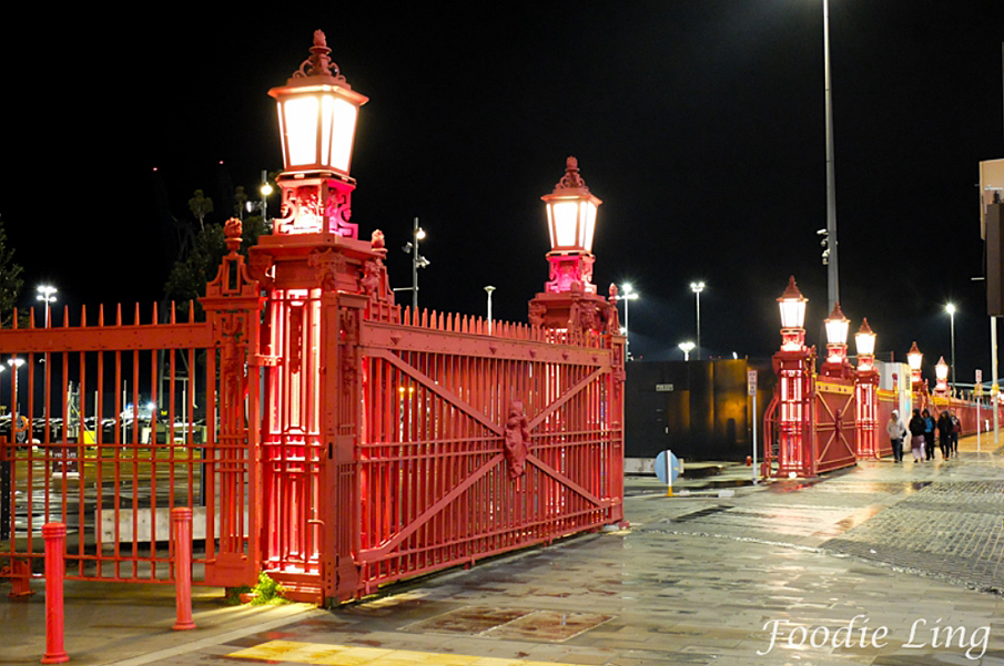
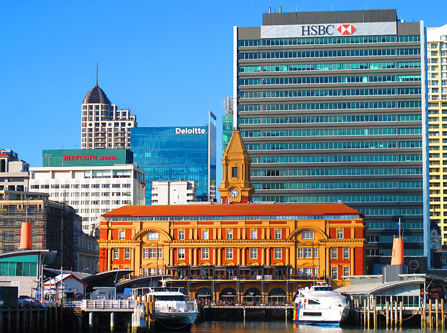

Sign up to hear more
Get the latest heritage news, features and events delivered
straight to your inbox.
