

The section on which the house stands was subdivided in 1873, creating Lot 5 Rural Section 216a, and ownership for this parcel was transferred to Elizabeth Watkins, wife of noted early settler and Mayor, Henry Green Watkins. Three years later, in 1876, Watkins sold to Pigeon Bay dairy farmer John Hemingway. By the time of his death in 1878, there were two houses on Lot 5 and this remains the case, the rear house being registered as a historic place (NZHPT Record Number 1725). Both 147A and 147B Rue Jolie are within the registered Akaroa Historic Area (NZHPT Record Number 7443).
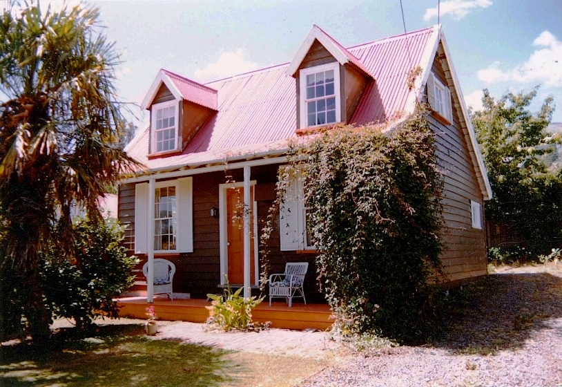
The two houses are quite different in style. That at the rear, 147B Rue Jolie, is a one and a half storeyed timber cottage, with a verandah, small multi-paned double hung sash windows without horns at the corners, those at the upper level being dormer windows set into a steeply pitched roof. In contrast, the house at the front of this section, at 147A Rue Jolie, fronting the street is a much plainer single storeyed Georgian box-style cottage with a hipped roof, wider double hung sash windows with horns, and a central four-panelled door. If both houses were built contemporaneously, it is curious that such different styles were employed. The rear house has the hallmarks of an earlier style of building and therefore may pre-date the front house at 147A Rue Jolie.
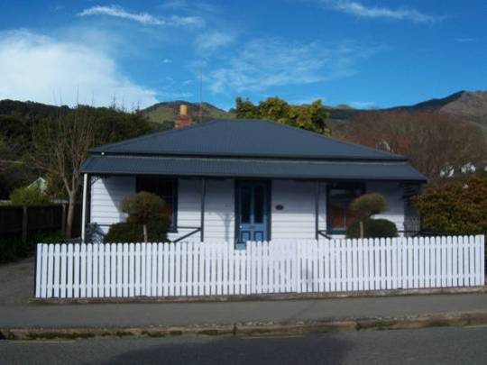
Like the wealth of other nineteenth century buildings in Akaroa, the house at 147A Rue Jolie has historical significance in exhibiting a clear link with historic settlement and in particular the development of the southern end of the township. As a small-scale Georgian box-styled cottage typical of others found in Akaroa and elsewhere in New Zealand, its form, scale and materials contribute to the wider historical streetscape of Rue Jolie, which in turn forms part of the wider cultural landscape of Akaroa within the harbour basin.
List Entry Information
Status
Listed
List Entry Status
Historic Place Category 2
Access
Private/No Public Access
List Number
9945
Date Entered
25th June 2010
Date of Effect
25th June 2010
City/District Council
Christchurch City
Region
Canterbury Region
Extent of List Entry
Extent includes the land described as Lot 1 DP 21949, Flat 1 DP 35213 (RT CB14B/1244), Canterbury Land District and the building known as 147A Rue Jolie thereon, and its fittings and fixtures (Refer to map in Appendix 1 of the registration report for further information).
Legal description
Lot 1 DP 21949, Flat 1 DP 35213 (RT CB14B/1244), Canterbury Land District
Location Description
The house is located on the west side of the southern part of Rue Jolie, in front of an historic timber house at 147B Rue Jolie.
Why is this place significant?
Historic Significance
Historical Significance or Value Like the wealth of other nineteenth century buildings in Akaroa, the house at 147A Rue Jolie exhibits a clear link with historic settlement and in particular the development of the southern end of the township. As a small-scale Georgian box-styled cottage typical of others found in Akaroa and elsewhere in New Zealand, including in Lyttelton also on Banks Peninsula, it is a representative house type. It is a contributing element of the historic Rue Jolie streetscape and provides clear physical evidence of trends in housing within a notable historic township.
Why is this place Category 1 / Category 2?
Detail Of Assessed Criteria
(a) The extent to which the place reflects important or representative aspects of New Zealand history The house at 147A Rue Jolie represents a common building type, the Georgian box-style house with central door flanked by sash windows and covered with a hipped roof. It occurs throughout New Zealand most commonly in the 1870s through the 1890s, though there are examples that fall both earlier and later than those decades. The house has additional interest in that its design clearly differs from a house on the rear of the same section, 147B Rue Jolie, and this provides an opportunity to compare approaches to and reasons for building relatively small residences in close proximity in the late nineteenth century. (e) The community association with, or public esteem for the place The house at 147A Rue Jolie is held in regard by the Akaroa community and visitors as part of a documented collection of noted buildings within a unique historic township. The owners have displayed a plaque on the west front of the house noting its historicity and the house is well cared for. (k) The extent to which the place forms part of a wider historical and cultural complex or historical and cultural landscape The form, scale and materials of the house at 147A Rue Jolie contribute to the wider historical streetscape of Rue Jolie which in turn forms part of the wider cultural landscape of Akaroa within the harbour basin. Summary of Significance or Values This place was assessed against, and found it to qualify under the following criteria: a, e, k. Conclusion It is considered that this place qualifies as a Category II historic place.
Construction Details
Start Year
1876
Finish Year
1878
Type
Original Construction
Description
Construction of two houses at the property
Start Year
1900
startYearCirca
Type
Demolished - prior building
Description
Redevelopment of or complete construction of front house at 147A Rue Jolie
Construction Materials
Timber, corrugated iron, glass, brick.
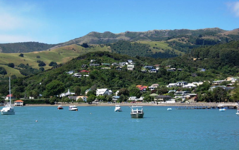
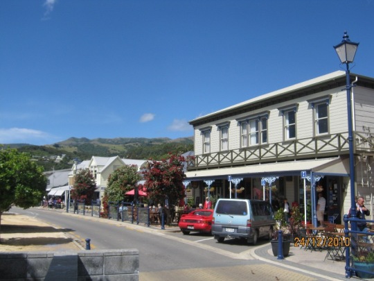
In pre-European times, Banks Peninsula (Te Pataka o Rakaihautu, the great food store house of Rakaihautu) was an important centre of Maori settlement, favoured for its sheltered harbours and valleys, rich fishing grounds, flourishing forests and bird life, and fresh running water. There were numerous Maori settlements around the large southern harbour on the peninsula, Akaroa harbour, including at a sheltered bay, Paka Ariki, the place that was later to become the European town of Akaroa. For Ngai Tahu, the harbour remains of great significance as a mahinga kai and Akaroa is part of a highly significant cultural landscape. By the turn of the nineteenth century, European seafarers (notably whalers) had discovered the harbour and were visiting Akaroa for fresh supplies. By the 1820s, British traders were seeking high quality, dressed flax fibre for ships' cordage, which was in short supply. By the 1820s an undefended flax trading village was established at Takapuneke, at a bay immediately south of the present Akaroa township, to supply visiting ships. A shocking event occurred in November 1830 when the brig Elizabeth anchored off Takapuneke, flying the British flag. Maori at Takapuneke expected to trade with the brig. Instead they were sabotaged and massacred. The brig's captain, John Stewart, had concealed a war party of Ngati Toa from the North Island, led by Te Rauparaha. It was this event that led directly to Britain appointing an official representative to New Zealand, to deter British subjects in New Zealand from committing such atrocities. It was the first step towards the British annexation of New Zealand and ultimately led to the signing of the Treaty of Waitangi in February 1840. In 1838, an enterprising French whaling captain, Jean Langlois, decided that Akaroa would be a good place to start French colonisation in New Zealand. He initiated a purported deed of sale for Banks Peninsula and returned to France where he persuaded some French merchants to join him in a French company, the Nanto-Bordelaise Company, to colonise Banks Peninsula. In March 1840, unaware of the British mission, but with the French King's approval, Langlois sailed for Akaroa in command of a converted storeship, renamed the Comte de Paris, with about 60 colonists and with supplies and equipment for a French settlement at Akaroa. It was anticipated this could expand to include the whole South Island. The French government also supplied a 32 gun corvette called L'Aube which had already left France under Captain Charles Lavaud, to guard the new colony and the local French whaling fleet. By the time the French colonists arrived in Akaroa in August 1840, however, the Union Jack flag was already flying at Greens Point (Takapuneke) as proof that New Zealand had been annexed by the British. A copy of the Treaty of Waitangi had, in May 1840, already been signed by Maori at nearby Onuku. Although unsuccessful, it is these intentions of the French to colonise the area that makes Akaroa's colonial settlement history unique in New Zealand. Even though the British had formally colonised the whole of New Zealand, the French arrivals and their German companions decided to stay in Akaroa alongside the British. The resulting mixed colonial population made Akaroa unusual in New Zealand, with the French setting up at the north end of the town and the English at the south. As elsewhere in New Zealand, European settlement of the Akaroa area had serious consequences for local Maori, as loss of their lands removed their ability to cultivate food and thus to trade. Akaroa, one of the first organised European settlements in New Zealand, is an exceptionally well preserved example of a small New Zealand colonial town and its character is clearly set by its historic buildings within a dramatic landscape of an extinct volcanic crater and harbour setting. Although a small number of buildings survive from the period 1840s-1860s, most of the historic buildings and structures in Akaroa township date from the 1870s through to the early 1900s, when Akaroa was developing its rural and maritime servicing roles. Genuine French design elements are to be found in the area such as the metric width of the streets (12 metres) and French European trees, roses and vines descended from French originals. However, Akaroa's architectural character is predominantly British colonial, with its buildings typified by weatherboard construction, steeply pitched roofs with dormer windows, verandahs and sash windows. Collectively, Akaroa's buildings and structures contribute to the streetscapes and the interrelationship between the town, hills and sea. This special significance of Akaroa has been recognised by the NZHPT with registrations of the Akaroa Waterfront Historic Area (Record No. 7330) and Akaroa Historic Area (Record No. 7443). In recognition of the town's particularly high concentration of historic buildings, the Akaroa Historic Area was the largest historic area to be added to the Register at its time of registration in 1999. In addition, Akaroa has the highest number of registrations compared to other historic towns of a similar size. A Plan of the Town of Akaroa, surveyed by Boys and Davie 1852-6 and drawn in 1878, shows the southern part of Akaroa containing large parcels of land which were in fact by the 1870s subdivided into residential sections. The large Land parcel 216, shown on the 1878 map, on the corner of Jolie Street (Rue Jolie) and Aylmer Street was granted by the Canterbury Association to Reverend William Aylmer in 1851. A section of 1 acres, 1 rood and 10 perches of this land was purchased by Samuel Farr from Reverend Aylmer in 1857. This section was triangular, including all of the west side of Rue Jolie (south) above Aylmer's Stream. Farr sold the whole section in 1863 and it remained as one block until it was transferred to Elizabeth Watkins, wife of Henry Green Watkins, and subdivided in 1873. Henry Green Watkins (1829-1879), son of early Canterbury settler Dr Daniel Watkins (1791-1882), was an early Akaroa pharmacist and later mayor of Akaroa. Henry's father, Dr Watkins, shifted from his earlier Akaroa house to a new one built for him in 1876 at 113 Rue Jolie. Just up the road, at 147 Rue Jolie, Lot 5 Rural Section 216a, was purchased in 1876 by Pigeon Bay dairy farmer John Hemingway (1834-78). By the time of his death in 1878, there were two houses on Hemingway's Lot 5 RS 216. Akaroa had seen something of a 'building boom' in the 1870s. By 1877 the town had two Building Surveyors (one being J Hemingway) and 19 carpenters and joiners. An area of notable building activity was in the Rue Jolie south area in circa 1875-1876, complementing existing houses there of the 1860s. By 1900 both houses at 147 Rue Jolie were 'in a very dilapidated state' and the sole beneficiary of Hemingway's estate, daughter Sarah Jane Hemingway, was unable to afford the considerable maintenance expenses. The Public Trust was given permission to sell and dispose of the property on behalf of Sarah Hemingway and in 1905 the property, including its buildings, was conveyed to Thomas Brittan. Brittan, a retired farmer, died in December 1924 and thereafter the property was again conveyed by the Public Trust. Although it is documented that two houses were already in existence on the property by 1878, the style of the two houses are markedly different. That at the rear, 147B Rue Jolie, is a one and a half storeyed timber cottage, with a verandah, small multi-paned double hung sash windows without horns at the corners, those at the upper level being dormer windows set into a steeply pitched roof. The style of this house is similar to many others from the mid nineteenth century in Akaroa. In contrast, the house at the front of this section, at 147A Rue Jolie, fronting the street is a much plainer single storeyed Georgian box-style cottage with a hipped roof, wider double hung sash windows with horns, and a central four-panelled door. Its style is of a type used over many decades and bears similarities to other cottages in Rue Jolie south such as 117 Rue Jolie (1876) Although it is possible that the front house (147A Rue Jolie) is contemporary with the rear house and could have been built in the late 1870s, its style is clearly different, and therefore it is most likely to have been built (or altered) at a later date than 147B Rue Jolie at the rear. One possibility is that the house at the rear was built prior to Hemingway's purchase of the land, that is, before 1876. The land was not subdivided to Lot 5 until 1873 when Elizabeth Watkins took ownership, and it is possible that the rear house was built from this time, 1873-6. The house at the front then may have been built by Hemingway between 1876-78. Alternatively, if the two houses were built by Hemingway in 1876-78, the front one may have subsequently been either drastically altered or completely replaced. It is not clear which was the case. A plan showing subdivisions of Section 216A, dated 25 February 1901 from a survey of 1896, shows a house apparently with the exact footprint of the present house at 147A Rue Jolie so it appears to have been in place well by this time. Another, possibly less likely, scenario is that such redevelopment could have happened in the first decade of the twentieth century, from the time that Thomas Brittan purchased the property in 1905, but if this is the case it must have utilised the exact footprint of the building shown in the 1896 surveyed map. The two houses remained on the same title until 1974 when the section was resurveyed and the front house on the lot was sold with a cross lease on the same section. Both houses are included within the Akaroa Township Historic Area registration.
In pre-European times, Banks Peninsula (Te Pataka o Rakaihautu, the great food store house of Rakaihautu) was an important centre of Maori settlement, favoured for its sheltered harbours and valleys, rich fishing grounds, flourishing forests and bird life, and fresh running water. There were numerous Maori settlements around the large southern harbour on the peninsula, Akaroa harbour, including at a sheltered bay, Paka Ariki, the place that was later to become the European town of Akaroa. For Ngai Tahu, the harbour remains of great significance as a mahinga kai and Akaroa is part of a highly significant cultural landscape. By the turn of the nineteenth century, European seafarers (notably whalers) had discovered the harbour and were visiting Akaroa for fresh supplies. By the 1820s, British traders were seeking high quality, dressed flax fibre for ships' cordage, which was in short supply. By the 1820s an undefended flax trading village was established at Takapuneke, at a bay immediately south of the present Akaroa township, to supply visiting ships. A shocking event occurred in November 1830 when the brig Elizabeth anchored off Takapuneke, flying the British flag. Maori at Takapuneke expected to trade with the brig. Instead they were sabotaged and massacred. The brig's captain, John Stewart, had concealed a war party of Ngati Toa from the North Island, led by Te Rauparaha. It was this event that led directly to Britain appointing an official representative to New Zealand, to deter British subjects in New Zealand from committing such atrocities. It was the first step towards the British annexation of New Zealand and ultimately led to the signing of the Treaty of Waitangi in February 1840. In 1838, an enterprising French whaling captain, Jean Langlois, decided that Akaroa would be a good place to start French colonisation in New Zealand. He initiated a purported deed of sale for Banks Peninsula and returned to France where he persuaded some French merchants to join him in a French company, the Nanto-Bordelaise Company, to colonise Banks Peninsula. In March 1840, unaware of the British mission, but with the French King's approval, Langlois sailed for Akaroa in command of a converted storeship, renamed the Comte de Paris, with about 60 colonists and with supplies and equipment for a French settlement at Akaroa. It was anticipated this could expand to include the whole South Island. The French government also supplied a 32 gun corvette called L'Aube which had already left France under Captain Charles Lavaud, to guard the new colony and the local French whaling fleet. By the time the French colonists arrived in Akaroa in August 1840, however, the Union Jack flag was already flying at Greens Point (Takapuneke) as proof that New Zealand had been annexed by the British. A copy of the Treaty of Waitangi had, in May 1840, already been signed by Maori at nearby Onuku. Although unsuccessful, it is these intentions of the French to colonise the area that makes Akaroa's colonial settlement history unique in New Zealand. Even though the British had formally colonised the whole of New Zealand, the French arrivals and their German companions decided to stay in Akaroa alongside the British. The resulting mixed colonial population made Akaroa unusual in New Zealand, with the French setting up at the north end of the town and the English at the south. As elsewhere in New Zealand, European settlement of the Akaroa area had serious consequences for local Maori, as loss of their lands removed their ability to cultivate food and thus to trade. Akaroa, one of the first organised European settlements in New Zealand, is an exceptionally well preserved example of a small New Zealand colonial town and its character is clearly set by its historic buildings within a dramatic landscape of an extinct volcanic crater and harbour setting. Although a small number of buildings survive from the period 1840s-1860s, most of the historic buildings and structures in Akaroa township date from the 1870s through to the early 1900s, when Akaroa was developing its rural and maritime servicing roles. Genuine French design elements are to be found in the area such as the metric width of the streets (12 metres) and French European trees, roses and vines descended from French originals. However, Akaroa's architectural character is predominantly British colonial, with its buildings typified by weatherboard construction, steeply pitched roofs with dormer windows, verandahs and sash windows. Collectively, Akaroa's buildings and structures contribute to the streetscapes and the interrelationship between the town, hills and sea. This special significance of Akaroa has been recognised by the NZHPT with registrations of the Akaroa Waterfront Historic Area (Record No. 7330) and Akaroa Historic Area (Record No. 7443). In recognition of the town's particularly high concentration of historic buildings, the Akaroa Historic Area was the largest historic area to be added to the Register at its time of registration in 1999. In addition, Akaroa has the highest number of registrations compared to other historic towns of a similar size. A Plan of the Town of Akaroa, surveyed by Boys and Davie 1852-6 and drawn in 1878, shows the southern part of Akaroa containing large parcels of land which were in fact by the 1870s subdivided into residential sections. The large Land parcel 216, shown on the 1878 map, on the corner of Jolie Street (Rue Jolie) and Aylmer Street was granted by the Canterbury Association to Reverend William Aylmer in 1851. A section of 1 acres, 1 rood and 10 perches of this land was purchased by Samuel Farr from Reverend Aylmer in 1857. This section was triangular, including all of the west side of Rue Jolie (south) above Aylmer's Stream. Farr sold the whole section in 1863 and it remained as one block until it was transferred to Elizabeth Watkins, wife of Henry Green Watkins, and subdivided in 1873. Henry Green Watkins (1829-1879), son of early Canterbury settler Dr Daniel Watkins (1791-1882), was an early Akaroa pharmacist and later mayor of Akaroa. Henry's father, Dr Watkins, shifted from his earlier Akaroa house to a new one built for him in 1876 at 113 Rue Jolie. Just up the road, at 147 Rue Jolie, Lot 5 Rural Section 216a, was purchased in 1876 by Pigeon Bay dairy farmer John Hemingway (1834-78). By the time of his death in 1878, there were two houses on Hemingway's Lot 5 RS 216. Akaroa had seen something of a 'building boom' in the 1870s. By 1877 the town had two Building Surveyors (one being J Hemingway) and 19 carpenters and joiners. An area of notable building activity was in the Rue Jolie south area in circa 1875-1876, complementing existing houses there of the 1860s. By 1900 both houses at 147 Rue Jolie were 'in a very dilapidated state' and the sole beneficiary of Hemingway's estate, daughter Sarah Jane Hemingway, was unable to afford the considerable maintenance expenses. The Public Trust was given permission to sell and dispose of the property on behalf of Sarah Hemingway and in 1905 the property, including its buildings, was conveyed to Thomas Brittan. Brittan, a retired farmer, died in December 1924 and thereafter the property was again conveyed by the Public Trust. Although it is documented that two houses were already in existence on the property by 1878, the style of the two houses are markedly different. That at the rear, 147B Rue Jolie, is a one and a half storeyed timber cottage, with a verandah, small multi-paned double hung sash windows without horns at the corners, those at the upper level being dormer windows set into a steeply pitched roof. The style of this house is similar to many others from the mid nineteenth century in Akaroa. In contrast, the house at the front of this section, at 147A Rue Jolie, fronting the street is a much plainer single storeyed Georgian box-style cottage with a hipped roof, wider double hung sash windows with horns, and a central four-panelled door. Its style is of a type used over many decades and bears similarities to other cottages in Rue Jolie south such as 117 Rue Jolie (1876) Although it is possible that the front house (147A Rue Jolie) is contemporary with the rear house and could have been built in the late 1870s, its style is clearly different, and therefore it is most likely to have been built (or altered) at a later date than 147B Rue Jolie at the rear. One possibility is that the house at the rear was built prior to Hemingway's purchase of the land, that is, before 1876. The land was not subdivided to Lot 5 until 1873 when Elizabeth Watkins took ownership, and it is possible that the rear house was built from this time, 1873-6. The house at the front then may have been built by Hemingway between 1876-78. Alternatively, if the two houses were built by Hemingway in 1876-78, the front one may have subsequently been either drastically altered or completely replaced. It is not clear which was the case. A plan showing subdivisions of Section 216A, dated 25 February 1901 from a survey of 1896, shows a house apparently with the exact footprint of the present house at 147A Rue Jolie so it appears to have been in place well by this time. Another, possibly less likely, scenario is that such redevelopment could have happened in the first decade of the twentieth century, from the time that Thomas Brittan purchased the property in 1905, but if this is the case it must have utilised the exact footprint of the building shown in the 1896 surveyed map. The two houses remained on the same title until 1974 when the section was resurveyed and the front house on the lot was sold with a cross lease on the same section. Both houses are included within the Akaroa Township Historic Area registration.
The single storeyed timber house at 147A Rue Jolie is located on the east side of the southern part of Rue Jolie in Akaroa. Fronting the street, it sits less than ten metres in front of the one and a half storeyed timber house of a similar plan size at 147B Rue Jolie, within the same section of land. The house at 147A Rue Jolie is a relatively plain, small cottage, apparently built to a standard plan. It has a corrugated iron hipped roof, and a straight roofed verandah fronts the street which includes cast iron trim of stock design. The house was built mainly of totara, with kauri match lining throughout including ceilings. From a central front door, a passage led through to a kitchen and bedroom at the rear. An oval plaque noting that the house is a registered historic building in Akaroa is attached to the west front. Contextual Analysis Akaroa has retained its village scale with a solid reputation as a special place with a high proportion of historic buildings. In particular, its single or one and a half storeyed timber cottages are considered the norm of Akaroa's nineteenth century domestic architecture. Most residents of Akaroa throughout the second half of the nineteenth century were people of modest means; hence cottages and smaller houses predominate over larger ones. As the nineteenth century advanced, even these smaller dwellings tended to be decorated or embellished in some way, often in the bargeboards or with verandah and window detailing. Although the building styles are typically 'Colonial Vernacular' found elsewhere in New Zealand, Akaroa is unusual as a town because such a large number of these nineteenth century buildings have survived in the relatively small area occupied by the nineteenth century town. This gives the town its special atmosphere and character today. Along with Percy Street, William Street, Rue Balguerie and Rue Grehan, Rue Jolie south is recognised as a part of the older town where single and one and a half storey cottages abound. A recent Akaroa Historical Overview report has identified the southern length of Rue Jolie, from the Beach Road corner up the entrance of the Garden of Tane as having the most important concentration of Akaroa's smaller nineteenth century houses. This stretch of road is also noted for having examples of houses built throughout the twentieth century, making the street a remarkably comprehensive catalogue of New Zealand domestic architectural styles, in a manner akin to some Lyttelton streetscapes. Unfortunately, the town has lost a number of historic cottages and other buildings, notably in the 1980s and 1990s. Nikau Cottage, at 130 Rue Jolie, just down from 147A Rue Jolie on the opposite side of the street, for example, now sits isolated between modern buildings where previously it was part of a continuous row of four older dwellings. 147[A] and 147B Rue Jolie form part of published list of extant town fabric dating from 1850-1900 and are considered to form part of this important streetscape.
The single storeyed timber house at 147A Rue Jolie is located on the east side of the southern part of Rue Jolie in Akaroa. Fronting the street, it sits less than ten metres in front of the one and a half storeyed timber house of a similar plan size at 147B Rue Jolie, within the same section of land. The house at 147A Rue Jolie is a relatively plain, small cottage, apparently built to a standard plan. It has a corrugated iron hipped roof, and a straight roofed verandah fronts the street which includes cast iron trim of stock design. The house was built mainly of totara, with kauri match lining throughout including ceilings. From a central front door, a passage led through to a kitchen and bedroom at the rear. An oval plaque noting that the house is a registered historic building in Akaroa is attached to the west front. Contextual Analysis Akaroa has retained its village scale with a solid reputation as a special place with a high proportion of historic buildings. In particular, its single or one and a half storeyed timber cottages are considered the norm of Akaroa's nineteenth century domestic architecture. Most residents of Akaroa throughout the second half of the nineteenth century were people of modest means; hence cottages and smaller houses predominate over larger ones. As the nineteenth century advanced, even these smaller dwellings tended to be decorated or embellished in some way, often in the bargeboards or with verandah and window detailing. Although the building styles are typically 'Colonial Vernacular' found elsewhere in New Zealand, Akaroa is unusual as a town because such a large number of these nineteenth century buildings have survived in the relatively small area occupied by the nineteenth century town. This gives the town its special atmosphere and character today. Along with Percy Street, William Street, Rue Balguerie and Rue Grehan, Rue Jolie south is recognised as a part of the older town where single and one and a half storey cottages abound. A recent Akaroa Historical Overview report has identified the southern length of Rue Jolie, from the Beach Road corner up the entrance of the Garden of Tane as having the most important concentration of Akaroa's smaller nineteenth century houses. This stretch of road is also noted for having examples of houses built throughout the twentieth century, making the street a remarkably comprehensive catalogue of New Zealand domestic architectural styles, in a manner akin to some Lyttelton streetscapes. Unfortunately, the town has lost a number of historic cottages and other buildings, notably in the 1980s and 1990s. Nikau Cottage, at 130 Rue Jolie, just down from 147A Rue Jolie on the opposite side of the street, for example, now sits isolated between modern buildings where previously it was part of a continuous row of four older dwellings. 147[A] and 147B Rue Jolie form part of published list of extant town fabric dating from 1850-1900 and are considered to form part of this important streetscape.
Historical and Associated Iwi / Hapū / Whānau
Completion Date
30th March 2010
Report Written By
Robyn Burgess and Christine Whybrew
Information Sources
Ogilvie, 1990
G. Ogilvie, Banks Peninsula; the Cradle of Canterbury, GP Books, 1990
Allison, 1990
Barbara Allison, An Akaroa Precinct, Christchurch, 1990.
Turner, 1977
Gwenda Turner, Akaroa, Banks Peninsula, New Zealand, Dunedin, 1977.
Other Information
A copy of the original report is available from the NZHPT Southern region office. Please note that entry on the New Zealand Heritage List/Rarangi Korero identifies only the heritage values of the property concerned, and should not be construed as advice on the state of the property, or as a comment of its soundness or safety, including in regard to earthquake risk, safety in the event of fire, or insanitary conditions.
Current Usages
Uses: Accommodation
Specific Usage: House
Former Usages
General Usage: Accommodation
Specific Usage: House
Current Usages
Uses: Accommodation
Specific Usage: House
Former Usages
General Usage: Accommodation
Specific Usage: House
Location
Sign up to hear more
Get the latest heritage news, features and events delivered
straight to your inbox.
