

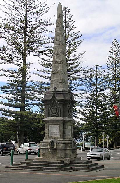
The 1897 Flood Heroism Memorial is located at the northern end of Marine Parade, Napier. It commemorates ten men who died on 16 April 1897 trying to rescue residents of the settlement of Clive during a major flood. Built three years after the devastating event, the memorial has historical significance as the first memorial of its kind among only a few that commemorate New Zealand’s most common form of natural disaster. It has symbolic importance as a surrogate tombstone for six of the ten men, whose bodies were never recovered. A service held at the memorial to mark the centenary of the men’s deaths, attended by their descendants, demonstrates the memorial’s enduring community esteem. Public funding enabled the creation of the memorial, with the impetus for the project coming from John Vigor Brown (1854-1942), a prominent businessman who later became a well-regarded Mayor of Napier. It was designed by David Bruce Frame, a Napier architect who also designed Napier’s war memorial Cenotaph and other buildings in the city that still stand today. The Gothic Revival monument took the form of a limestone obelisk atop a squared and carved Timaru bluestone column. Marble plaques on each face described the flood event and listed the ten men’s names. The limestone plinth incorporated a drinking fountain niche on each elevation, the water flowing from bronze lion’s head reliefs into curved bowls protruding from beneath pointed arches. The memorial survived the major 1931 Hawke’s Bay earthquake but suffered damage to its upper half, which was restored around 1935. Each side of the monument originally contained chain link fencing and planting bordering the steps up to the drinking fountain recesses. However, the monument no longer functions as a drinking fountain and the fencing and planting have been removed, with the memorial now fully incorporated into the footpath. The memorial occupies a prominent place in the landscape, on Marine Parade, and is part of a wider commemorative space.
Location
List Entry Information
Overview
Detailed List Entry
Status
Listed
List Entry Status
Historic Place Category 2
Access
Able to Visit
List Number
1115
Date Entered
2nd February 2020
Date of Effect
3rd March 2020
City/District Council
Napier City
Region
Hawke's Bay Region
Extent of List Entry
Extent includes part of the land described as Legal Road, Hawkes Bay Land District, and the structure known as 1897 Flood Heroism Memorial thereon. Extent includes a 2-metre curtilage around the structure, measured from the base of the steps. (Refer to map in Appendix 1 of the List entry report for further information).
Legal description
Legal Road, Hawkes Bay Land District
Location Description
E1937101.46, N5621870.07 (NZTM)
Cultural Significance
Social Significance or Value The bodies of six of the ten men who died trying to rescue the flood victims were never recovered. The 1897 Flood Heroism Memorial’s location close to the sea on Marine Parade reflects the final resting place of these men who have no gravesite on land. As a place that descendants of the men can visit to remember them it serves an important social function as a surrogate tombstone, while others can be reminded of and contemplate the forces of nature that have affected many. Its ongoing meaning to the community is reflected by events such as the service commemorating the centenary of the event, attended by descendants of the drowned heroes and members of the public who wanted to show their respects, and its maintenance by Napier City Council. The 1897 Flood Heroism Memorial has been a prominent feature on Marine Parade for over a century, and although it no longer boasts the drawcard of a drinking fountain it forms a part of the everyday fabric of local residents, a backdrop for the many people who encounter it each day. Although its surroundings have seen major change, the memorial has been retained. It is a valued element of Marine Parade’s significant commemorative landscape of various memorials and monuments.
Historic Significance
Historical Significance or Value The 1897 Flood Heroism Memorial has historical significance as a physical reminder of a devastating nineteenth century flood in the Hawke’s Bay. New Zealand has a history of major floods that were particularly destructive during early European settlement before comprehensive flood protection measures were put in place. The flood of Easter 1897 prompted the formation of the Hawke’s Bay River Board and influenced the development of the region’s major flood control schemes, and the reclamation work that enabled Napier and its surrounding area to grow as an urban environment. The memorial is the first of its kind among only a few public memorials that remember those who lost their lives during a common form of natural disaster. Whereas many other memorials in New Zealand commemorate men who died during military service or who achieved renown in political life, the 1897 Flood Heroism Memorial recognises ten ‘everyday’ men who died while trying to help fellow citizens. It is also of historical significance for its construction at the very cusp of an era in which public memorials became much more common. The memorial is connected to prominent figures in Napier’s early history such as successful businessman and Mayor of Napier, John Vigor Brown, who initiated the creation of a memorial, architect David Frame, who designed the Napier war memorial Cenotaph and buildings that still exist today, and Mayor George Henry Swan who officially unveiled the memorial.
Detail Of Assessed Criteria
It is considered that this place qualifies as a Category 2 historic place. It was assessed against all criteria, and found to qualify under the following: a, b, e, f, h, k. (a) The extent to which the place reflects important or representative aspects of New Zealand history The 1897 Flood Heroism Memorial is one of only a few public monuments in New Zealand that commemorate loss of life due to a major flooding event. Flooding is a frequent and costly natural event in New Zealand and the geographic features of Hawke’s Bay mean that the area is particularly prone to flooding, while unfortunately drowning became known as ‘the New Zealand death’ soon after colonial settlement, and remains a common cause of fatality. Preventative measures have decreased the incidence of major flooding in the Hawke’s Bay in modern times, so the memorial stands as an important reminder of the danger floods posed to colonial settlers in Napier and wider New Zealand. (b) The association of the place with events, persons, or ideas of importance in New Zealand history The 1897 Flood Heroism Memorial was the idea of John Vigor Brown, a prominent businessman in Napier who later served as Mayor of Napier for many years. He was responsible for introducing many new amenities and public works in Napier. His final term as Mayor included the devastating 1931 Hawke’s Bay earthquake and he provided strong leadership in the aftermath of the earthquake. The memorial is an early example of Vigor Brown’s civic interests and was the first memorial structure to be erected on Marine Parade, which later became a key commemorative space in Napier. The memorial was built as one of the very first such memorials in the country, just as a phase of memorialisation began in the early twentieth century. (e) The community association with, or public esteem for, the place The majority of the ten men who died on 16 April 1897 were residents of Napier and seven of the men had children. At the wreath laying service held to commemorate the centenary of the men’s deaths in 1997, descendants of the men placed tributes on the 1897 Flood Heroism Memorial demonstrating that members of the men’s families still have a connection to the memorial. It has been a prominent feature on Marine Parade for over one hundred years and was not moved or altered when major changes occurred on land behind it in 2001, instead its accessibility was increased by its incorporation into a busy public footpath. This demonstrates how it is valued by the people of Napier as an important element in the significant collection of commemorative structures along Marine Parade. (f) The potential of the place for public education The 1897 Flood Heroism Memorial is situated in a prominent public place with high foot traffic. Two of its plaques record the major 1897 flood and have the potential to educate those who stop to read them about the incidence of major flooding in the Hawke’s Bay, particularly prior to modern flood protection measures. The nearby MTG Hawke’s Bay includes a permanent exhibition about the major 1931 earthquake, but public education about the history of flooding in the region receives far less attention. The memorial is imposing and sombre and provides an enduring visual manifestation of the dangers of natural disasters. (h) The symbolic or commemorative value of the place The 1897 Flood Heroism Memorial commemorates ten men who died on Friday 16 April 1897 during an attempt to rescue residents of the township of Clive during a major flood. The bodies of six of the men were never recovered, so the Memorial acts as a surrogate tombstone for these six men. On the centenary of the men’s deaths, a memorial service was held during which descendants of the men placed wreaths on the Memorial, demonstrating the enduring commemorative nature of the monument. (k) The extent to which the place forms part of a wider historical and cultural area The 1897 Flood Heroism Memorial is located on Marine Parade, Napier’s popular seaside promenade. As one of a number of memorial structures along Marine Parade, including the 1906 South African War Memorial, the 1917 Swan Memorial Pool Shelter, the 1933 Kirk Sundial, 1934 Veronica Sunbay, 1937 Colonnade, 1947 Percy Spiller Memorial, 1982 Swan Memorial Lamp, 1993 Reflecting Ball, 1999 HMNZS Tui Anchor and the 2000 Millennial Arch, it not only forms an important element of a significant wider commemorative landscape, but its construction in 1899-1900 began the use of this space for commemorative purposes. In close proximity to other survivors of the 1931 earthquake such as the Napier Soldiers’ Club (Former) (List No. 9967), the Borough Council Chambers (Former) (List No. 2794) and the Hawke’s Bay Club (List No. 180), it helps provide continuity with the city’s pre-quake landscape.
Construction Professional
Biography
D B Frame, the architect who designed the homestead and stables at Aramoana, practised architecture in Napier for about 30 years. He was referred to as an architect in the Hawked Bay Almanac in 1885. In 1894, he was engaged by A Mc Hardy to design Aramoana for his second son Percival. Over the years he designed a variety of buildings but mainly houses and some banks. In the early years he combined with a more successful architect, W P Finch, in several projects. David Bruce Frame was an architect and civil engineer who spent most of his life in Napier. He designed a variety of buildings, sometimes in partnership with other notable architects, such as the Abbott’s Building (1932) with J.A. Louis Hay. Other buildings known to have been designed by Frame include the Aramoana Station Homestead (1894, Category 1 historic place), the Ancient Order of Foresters building (1919, currently Napier’s Quest Hotel) and the former McCulloch Butler & Spence Building (1929). He also designed another significant Napier monument, the 1897 Flood Heroism Memorial (List No. 1115) located on Marine Parade and unveiled in September 1900. Frame died in 1938 at the age of 75. Source: Proposal Report for Cenotaph, Napier (List No. 1113)
Name
Frame, David Bruce
Type
Architect
Biography
Metal casting engineers for the 1897 Flood Heroism Memorial Fountain, Napier. Source: List Entry Report for the 1897 Flood Heroism Memorial Fountain, NAPIER, List No. 1115, Cherie Jacobson and Elizabeth Cox, 12 November 2019
Name
J. J. Niven and Co.
Type
Engineer
Biography
Plumber for the 1897 Flood Heroism Memorial Fountain, Napier. Source: List Entry Report for the 1897 Flood Heroism Memorial Fountain, NAPIER, List No. 1115, Cherie Jacobson and Elizabeth Cox, 12 November 2019
Name
J. Constable
Type
Plumber
Biography
Builder, concrete steps of the 1897 Flood Heroism Memorial Fountain. Source: List Entry Report for the 1897 Flood Heroism Memorial Fountain, NAPIER, List No. 1115, Cherie Jacobson and Elizabeth Cox, 12 November 2019
Name
J. King
Type
Builder
Biography
No biography is currently available for this construction professional
Name
Fraser, E.
Type
Builder
Biography
No biography is currently available for this construction professional
Name
McNamara, P.
Type
Stonemason
Construction Details
Finish Year
1900
Start Year
1899
Type
Original Construction
Description
Damaged during the Hawke’s Bay earthquake
Start Year
1931
Type
Damaged
Description
Earthquake damage repaired
Finish Year
1935
Type
Maintenance/repairs
Description
Surrounding fencing and planting added
Finish Year
1901
Type
Modification
Description
Changes made to surrounding landscape
Finish Year
2001
Type
Modification
Description
Fencing and planting removed; drinking fountain function disestablished
Period
Unknown
Type
Modification
Construction Materials
Timaru bluestone, crystalline limestone, marble, metal, concrete.
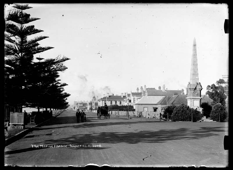
Early Napier The Ahuriri area’s rivers, wetlands, lagoons and fertile land produced important resources, making the area an attractive place to live. Settlement is thought to have begun in the twelfth or thirteenth century and Ngāti Kahungunu became the dominant iwi from the sixteenth century. There were several pā at what became Port Ahuriri and Napier, including an island pā, Te Pakake, just west of Mataruahou island (Scinde Island, later Napier/Hospital/Bluff Hill), Pukemokimoki to the south and Hukarere on top of Mataruahou. As a result of inter-tribal warfare, around the 1830s many local Ngāti Kahungunu sought refuge in Māhia. When missionaries and other Europeans began arriving in earnest after the signing of the Treaty of Waitangi, the exiles had returned and Te Koau, near Te Pakake, became the principal local pā. With the Ahuriri Purchase of 1851, the Crown acquired the lands between the Tutaekuri River and north to the Mohaka area, inclusive of Mataruahou and most of its surrounds. A few years later, in 1855, Napier was established by the government, with the town primarily located on the hill and around its base, as well as the narrow spits extending south and west. The site was not promising because road access was difficult and future expansion would be challenging. However, Napier had a port. This was an important factor in Napier becoming Hawke’s Bay’s early administrative, commercial, and social centre. The population rose steadily: 343 in 1858; to 3,514 in 1874; and 8,774 in 1901. Napier’s geography limited its growth, despite several reclamation projects, until the 1931 Hawke’s Bay Earthquake lifted the ground level by as much as 2.7 metres in some places. Flood-prone Hawke’s Bay The 1897 Flood Heroism Memorial is directly connected to the geographical history of the Hawke’s Bay. It also reflects the prevalence of drowning in New Zealand, both historically and to this day. It is a memorial to ten men who died on 16 April 1897 while attempting to rescue residents from the nearby settlement of Clive during a severe flood. Floods continue to be the ‘most frequent hazard in Hawke’s Bay’ as well as the ‘most frequent and costly natural disasters in New Zealand.’ The risk of flooding is high in the Hawke’s Bay because so much of the region’s land is low lying and settlement has occurred on river flood plains. There are a variety of factors that contribute to flooding in the Hawke’s Bay, including its climate (hot, dry periods followed by heavy rainfall), shallow soils, a lack of lake/wetland storage as a result of land reclamation in the area and the proximity of three major river mouths on the Heretaunga Plains. The Ngaruroro, Tukituki and Tutaekuri rivers discharge into the sea within approximately five kilometres of each other and certain wind, current and tidal conditions can cause water to back up in these rivers. This is particularly problematic during times of high rainfall. From as early as the 1860s, colonial settlers in the area were exploring the possibility of controlling rivers and preventing flooding. A network of stopbanks and protection systems now exists on both the Heretaunga and Ruataniwha Plains to reduce the effect of floods in the Hawke’s Bay. This has evolved over the last 130 years, with improvements informed by flooding events. Not long after colonial settlement in New Zealand, drowning became known as ‘the New Zealand death’ due to the high number of drownings each year. Rapidly rising rivers and the deceptively strong current of rivers in flood contributed to this. Even today, New Zealand has one of the highest fatal drowning rates amongst OECD (Organisation for Economic Co-operation and Development) countries, with drowning being the third highest cause of accidental death. The 1897 flood On Thursday 15 and Friday 16 April 1897, heavy rain led to water covering three-fifths of the Heretaunga Plains. At one point, 11.5 inches (29.21 centimetres) of rain fell in just two and a half hours. To the south of Napier, the small settlement of Clive was in a particularly vulnerable position, being located between the mouths of the Ngaruroro and Tukituki Rivers. By Friday afternoon (Good Friday), the rain had subsided but nevertheless telegrams from Clive were received by the Chief Traffic Clerk in Napier advising the Ngaruroro River was rising rapidly and, finally, ‘For God’s sake send us some help.’ A number of boats from Napier went to rescue residents of Clive, and numerous successful rescues occurred. Two boats were transported by special train in the early evening of Good Friday to Waitangi, near the mouths of the Tutaekuri and Ngaruroro rivers. This was as close as the train could get, as the railway line further on had been washed away. It seems that soon after the boats were launched and the train returned to Napier, floodwaters from the Ngaruroro broke through the railway embankment at Waitangi causing a large washout. It was initially thought the two boats, each holding five men, had successfully departed for Clive before the washout occurred and further rescue boats were launched that night. The initial newspaper reporting of the flood made no mention of missing boats. However, by Sunday 18 April, it was confirmed the ten men from the two boats initially launched at Waitangi had not been seen in Clive at all and a search began. Oars from each boat were found amongst wreckage on Wairoa Beach. Later in April, the bodies of two of the men, John Rose and Henry Brierly, were found by a steam trawler. An inquest determined the two men had ‘accidentally drowned in a brave attempt to save the lives of others’ and no further inquest would be necessary if bodies of other the men were found. In early May two further bodies, those of Constable Alfred Stephenson and John Prebble, were washed ashore. No other bodies from the rescue party were found. All ten men were presumed to have been washed out to sea and drowned. They were identified as Arthur McCartney (licensee of the Albion Hotel), John Rose (a commercial traveller from Sydney), John Prebble (the son of a local fruitier), Constable Alfred Stephenson, Henry Brierly (a wheelwright), Frederick Cassin (an auction mart clerk), Herbert Oborn (an employee of the Napier branch of the department store Kirkcaldie and Stains), Sergeant Florence O’Donovan, George Chambers (a blacksmith) and Frederick Ansell (a carpenter). Six of the men had wives and children, while Sergeant O’Donovan left behind ‘four motherless children.’ At least two other people drowned as a result of the flooding and hundreds of families were left homeless. Heavy damage occurred throughout the region, including to Napier, Hastings and a number of Māori settlements, and farmers lost houses, fences and tens of thousands of sheep. Numerous washouts of the railway line, roads and bridges occurred, and communication systems were lost. On Easter Monday the Evening Post described what it called ‘An Awful Tale of Woe,’ with water covering the entire Hawke’s Bay countryside. It said the whole township of Clive was underwater, and in the lower parts of Clive ‘only the tops of a few houses are visible, and several have been washed away.’ The cost of the damage to the province was estimated at £150,000. The storm was not confined to the Hawke’s Bay; damage was recorded throughout the lower part of the North island, and the ship the Zuleika sank near Cape Palliser with the loss of 12 lives. A national disaster was declared, and relief funds were opened. The flood led to the formation of the Hawke's Bay River Board, who worked to develop the region’s network of flood protection systems, while the way in which the Tutaekuri River had spread silt over the plains showed engineers that the same process could be used to reclaim land in the area. A memorial to the heroes In February the following year, local businessman John Vigor Brown (who would later serve as the Mayor of Napier for a total of 18 years) suggested a memorial be erected to the ten men. He argued the heroic deeds of working men were just as deserving of recognition as those of soldiers, and started a public subscription. Others also contributed: a fundraising concert was given by the City Band and a large carnival held on the Recreation Ground with 3,500 people in attendance. A meeting of subscribers to the memorial was held, chaired by the Mayor of Napier George Henry Swan, who had himself been involved in the rescue effort and had arranged the two boats and crew to be taken to Clive. A proposal for the memorial to contain a drinking fountain and be placed ‘in a prominent position on the Parade’ in Napier was agreed to. A public invitation to architects, stonemasons and others to present designs for the memorial was made and eventually a design by David Frame was adopted. David Bruce Frame was an architect and civil engineer who spent most of his life in Napier. He designed a variety of buildings, sometimes in partnership with other notable architects such as the Abbott’s Building (1932) with James Augustus Louis Hay. Other buildings known to have been designed by Frame include the Category One listed Aramoana Station Homestead (1894), the Ancient Order of Foresters building (1919) and the former McCulloch Butler & Spence Building (1929). He also designed another significant Napier monument, the war memorial Cenotaph (List No.1113) located in Memorial Square and unveiled in November 1924. The base section of the memorial and the tapered obelisk were made from local crystalline limestone, originally supplied by the Napier Harbour Board. Each of the four sides had a protruding curved bowl, into which a metal lion’s head was set, with water running from the mouth of the lion. Plaques were set on the northern and southern side of the memorial naming the men who died and the events that occurred. The central section was made from Timaru bluestone, providing a darker contrast to the limestone above and below it. The construction of the memorial, supervised by Frame, met with ‘many vexations’ and delays, including the discovery that ‘the third section of the monument would not stand the carving which it is to carry, the stone chipping off in huge flakes.’ The memorial was finally unveiled on 26 September 1900 in front of a large crowd, with Mayor Swan, members of the committee, the Bishop of Waiapu and the Fire Police in attendance. Swan gave a detailed account of the events of 16 April 1897 that led to the men’s deaths. The base was decorated for the event with trees associated with death and mourning throughout the world. Within the base was sealed a ‘specially prepared glass bottle’ containing accounts of the flood and the fundraising effort. The Mayor’s wife turned on the water for the fountains, and the Mayor promised that the council would ensure the fountains were cared for and the water would be kept running in perpetuity free of charge. Very few monuments had been raised in New Zealand in the nineteenth century, even to ‘great men’ or as war memorials. Indeed, Napier residents thought their memorial was one of a kind – at the opening of the memorial the Mayor said ‘The monument is unique, the first of its kind erected in New Zealand’, meaning, probably, the first to be built in memory of people lost in disasters. However, he was not aware of two others – one being an obelisk built in Timaru in 1883-1885 in memory of those lost in two shipwrecks, and an obelisk erected over the graves of those who died in the 1896 Brunner Mine disaster in the same month as the Napier memorial. However, the 1897 Flood Heroism Memorial is likely the first public monument to commemorate deaths as a result of flooding. The only other known flood memorials commemorate flood levels in Queenstown and Kelso and deaths as a result of the 1938 Kōpuawhara flood. From the beginning of the twentieth century many more memorials were built; as historian Jock Phillips writes, they became in this era ‘a way for Pākehā to endow the landscape with its own history and embellish cities with statuary.’ Ongoing care for the memorial The following month the Mayor recommended fencing and planting around the memorial and a local woman offered to meet the costs. An image of the memorial after this shows young trees planted in garden beds added to the four corners of the memorial, protected by chains connected to decorative posts that also create a pathway to each of the drinking fountains. The memorial was to suffer significant damage during the 1931 Hawke’s Bay earthquake. The magnitude 7.8 earthquake on 3 February 1931 killed at least 256 and injured thousands more. Buildings in Napier and the nearby city of Hastings crumbled and fire quickly tore through Napier’s central business district. The damage was catastrophic. Images of the memorial in the years immediately after the earthquake show the top two-thirds of the column missing, while the rest of the memorial appears to remain relatively intact. Small hedges or shrubs have replaced the trees planted in the garden beds. In 1932 Leonard Bestall (1895-1959), an architect, draper and later the first director of the Hawke’s Bay Art Gallery and Museum, stated the Memorial was one of the city’s pre-earthquake treasures and advocated for its speedy restoration. Newspaper reports from March 1935 mention that the Napier City Council planned to repair the memorial, but the exact date of the repairs is not known. A service was held on 16 April 1997 at the memorial to commemorate the centenary of the ten men’s deaths. The service was led by the Dean of St John’s Cathedral and was attended by around 20 people, including the great-niece of one of the men who died. The surroundings of the memorial have seen many changes since its construction. Originally its address was described as being at the intersection of Marine Parade and Byron Street, but its backdrop is now a hotel, since in 2001 the northern end of Byron Street was permanently closed. The memorial was incorporated into the footpath of Marine Parade. At this time, archaeological work found several early Māori fireplaces close to the memorial. At some point the fencing and planting were removed and it is no longer operational as a drinking fountain.
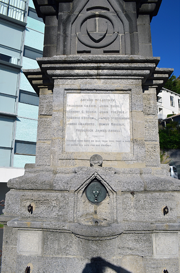
Current Description The 1897 Flood Heroism Memorial is located on the western footpath at the northern end of Marine Parade in Napier. Its 11-metre height and Gothic Revival-influenced masonry mark it out as an imposing figure in the seaside urban landscape, particularly when viewed in the context of the more contemporary architecture surrounding it. The memorial is a four-sided square column that tapers to a point. Each of the four sides has four concrete steps leading to the 5.8 metre base of the memorial, originally designed to provide access to the four drinking fountains set into the monument. The first section of the memorial is made from local crystalline limestone, originally supplied by the Napier Harbour Board. Each side has a protruding curved bowl beneath a pointed arch into which a small metal sculpture of a lion’s head is set, with water previously running from the mouth of the lion to form the drinking fountain. The lion sculpture is missing on the southern side of the memorial. Iron eyelet hooks protrude from the four corners of each side of the base; these were added after the construction of the monument to attach chain link fencing which has since been removed. One of the eyelet hooks is missing on the northern side of the memorial. At the top of the pointed arch is a circular form, and above that is a marble plaque set into the limestone. The plaques on the northern and southern sides of the memorial read: ‘This Monument / Was Erected / By The People Of Napier / To Commemorate / A Deed of Heroism / By Which Ten Men Lost Their Lives / On Good Friday 16th April 1897. / In Attempting To Rescue The / Flooded Out Settlers Of Clive.’ While the plaques on the eastern and western sides record the names of the deceased men and read: ‘Arthur McCartney. / Frederick Cassin. John Rose. / Herbert G. Orborn. John Prebble. / Florence O’Donovan. Alfred Stephenson. / George Chambers. Henry Brierly. / Frederick James Ansell. / Greater Love Hath No Man Than This, That A Man / Lay Down His Life For His Friends.’ The quote following the names of the men is John 15:13 from the King James Bible. The central section of the memorial is made from Timaru bluestone, providing a darker contrast to the limestone above and below it. The bluestone is carved on each side with a pointed arch that has a circular form at its tip. Within the arch are circular and triangular forms, with a shield shape at the centre. The upper tapered section, an obelisk which forms half of the total height of the memorial, is made from crystalline limestone like the base. Each horizontal row of limestone blocks alternates between a smooth and rough finish, up to the final smooth section that tapers into a four-sided triangular point. It is one of a number of memorial structures along Marine Parade, including the 1917 Swan Memorial Pool Shelter (List No. 1165), located almost directly opposite. Others include the 1906 South African War Memorial (List No. 1111), 1933 Kirk Sundial, 1934 Veronica Sunbay, 1937 Colonnade, 1947 Percy Spiller Memorial, 1982 Swan Memorial Lamp, 1993 Reflecting Ball, 1999 HMNZS Tui Anchor and the 2000 Millennial Arch. While the Memorial falls just outside the Napier City Centre Historic Area (List No. 7022), it is part of an area that includes other survivors of the 1931 earthquake, such as the Napier Soldiers’ Club (Former) (List No. 9967), the Borough Council Chambers (Former) (List No. 2794) and the Hawke’s Bay Club (List No. 180).
Completion Date
11th November 2019
Report Written By
Cherie Jacobson and Elizabeth Cox
Information Sources
Campbell, 1975
M. D. N. Campbell, Story of Napier, 1874-1974; Footprints Along the Shore
Daily Telegraph
Daily Telegraph
Te Ara - The Encyclopedia of New Zealand
www.TeAra.govt.nz
Te Ara - The Encyclopedia of New Zealand
www.TeAra.govt.nz
Hawke's Bay Herald
Hawke's Bay Herald
Hawke’s Bay Museum and Art Gallery
Hawke’s Bay Museum and Art Gallery
NIWA
NIWA Taihoro Nukurangi NZ Historic Weather Events Catalog
Report Written By
A fully referenced List Entry report is available on request from the Central Region Office of Heritage New Zealand Pouhere Taonga Please note that entry on the New Zealand Heritage List/Rārangi Kōrero identifies only the heritage values of the property concerned, and should not be construed as advice on the state of the property, or as a comment of its soundness or safety, including in regard to earthquake risk, safety in the event of fire, or insanitary conditions. Archaeological sites are protected by the Heritage New Zealand Pouhere Taonga Act 2014, regardless of whether they are entered on the New Zealand Heritage List/Rārangi Kōrero or not. Archaeological sites include ‘places associated with pre-1900 human activity, where there may be evidence relating to the history of New Zealand’. This List entry report should not be read as a statement on whether or not the archaeological provisions of the Act apply to the property (s) concerned. Please contact your local Heritage New Zealand office for archaeological advice.
Current Usages
Uses: Commemoration
Specific Usage: Memorial - Disaster
Uses: Commemoration
Specific Usage: Memorial - Particular person or group
Former Usages
General Usage:: Civic Facilities
Specific Usage: Fountain
Stay up to date with Heritage this month
