Situated on the banks of the Mangapai River in the southern Whangārei Harbour, Smedley Farmhouse (Former) lies within a contested landscape with connections to multiple iwi and has a long history of Māori settlement. The extensive forests and waterways in the area were important resources for Māori and included kauri which were considered a taonga. The place is an impressive late 1890s timber residence linked with the transition from extractive to renewable industry in rural northland communities. The place has historical significance as it reflects the dominant economic patterns in North Auckland both through its links with the gum trade providing the capital for its construction and quick expansion, and its later development as a farm under Frank Hilford who served as a local councillor. The place remains largely intact and has the potential to provide information about locally felled and processed kauri timber and construction techniques. Multiple iwi including have connections to the landscape near the Mangapai River, including Te Parawhau and Patuharakeke who settled the lands around Whangārei harbour. From 1854 notable Te Parawhau rangatira Te Tirarau Kūkupa led eleven Parawhau rangatira in transferring a number of land blocks around the harbour to the Crown. Te Mata block, including the site of Smedley Farmhouse (Former), was acquired by the Crown in 1858. Early Pākehā settlements in the area were reliant on extractive industries, particularly in kauri timber and gum which could be exported for national and international markets via coastal shipping routes serviced by the mosquito fleet which operated in northern New Zealand. Edwin Smedley dug – and possibly traded – gum near Dargaville prior to acquiring over 80 acres of land near Oakleigh Wharf in late 1892. After marrying Mary Hayward in 1894, Smedley built a one and a half storey wide gable cottage on his property. Solidly constructed of kauri timber from a local sawmill, the residence had four rooms downstairs with ladder access to additional rooms upstairs. Smedley continued to be involved in the kauri gum trade and, with the close proximity of the wharf, established a gum store, boarding house and store to cater to itinerant gum diggers in the area. The businesses were profitable and within a few years Smedley expanded the residence into an impressive 10 room farmhouse with the addition of a wide lean-to, wrap around verandah and balcony in circa 1900. Decorative features reminiscent of wealthy Whangārei villa style residences were added including rusticated weatherboards, timber fretwork, chamfered verandah posts as well as curved rafters for a concave verandah roof. As well as improving the house Smedley cleared his wider property, converting flax and fern scrub into pasture for stock farming. In 1901 Smedley sold the property to Hilford who fully transitioned the place to renewable industry as a farm raising sheep and likely later cattle for export to Britain in a period which has been referred to as recolonisation. Although the gum trading business ceased, the residence continued to have a public function as a local post office which was established from the residence in 1912 and continued to operate until 1945. As well as farming Hilford was involved in the rural community as a member of the Mangapai Riding Farmers Association for many years and as a local councillor. Hilford also collected export dues from users of the wharf. A later owner, Lucy Nutsford, regularly hosted the Women’s Institute and other clubs at the residence. From the 1920s, developments in rail and road transport reduced the importance of Oakleigh. Few changes were made to the place over the twentieth century except some internal room rearrangements and two sections of the verandah were enclosed. In later decades the farm was subdivided. The place remains a private residence.
Location
List Entry Information
Overview
Detailed List Entry
Status
Listed
List Entry Status
Historic Place Category 2
Access
Private/No Public Access
List Number
1235
Date Entered
7th July 2021
Date of Effect
7th July 2021
City/District Council
Whangārei District
Region
Northland Region
Extent of List Entry
Extent includes the land described as Lot 1 DP 165680 (RT NA95C/655), North Auckland Land District, and the buildings and structures known as Smedley Farmhouse (Former) thereon. (Refer to map in Appendix 1 of the List entry report for further information).
Legal description
Lot 1 DP 165680 (RT NA95C/655), North Auckland Land District.
Location Description
Located on a rural lifestyle block on State Highway 1 just before the Oakleigh garage, 13km south of Whangarei. Additional Location Information NZTM Easting: 1718785.0 NZTM Northing: 6033952
Historic Significance
Historical Significance or Value Smedley Farmhouse (Former) has historical significance as a place which reflects the outcomes for Pākehā settlers of the exploitation of the northern kauri forests and consequent development of the Auckland provincial economy, particularly the transition from extractive to renewable industries in the late nineteenth and early twentieth centuries. The importance of kauri timber and gum in regional economy is reflected in that the place was constructed from locally milled kauri timber and that its creation and quick expansion was funded through activities linked with the kauri gum trade including gum digging and use as a gum store and boarding house. The modifications to convert the early residence into an impressive farmhouse and its ensuing use through the twentieth century reflect the widespread shift to small scale farming in northern New Zealand after resources for extraction were exhausted. The place further shows how domestic and commercial activities were mixed in rural environments through its concurrent use as a residential home and farmhouse as well as store, boarding house and later post office. The location of the place near Oakleigh wharf reflects the importance of waterborne transport and the mosquito fleet in northern New Zealand for connecting rural communities with national and international markets.
Physical Significance
Archaeological Significance or Value Smedley Farmhouse (Former) was constructed in two phases in the late 1890s from locally sourced and milled kauri timber, and has the potential to provide information about turn of the century rural construction methods and timber processing from an identifiable source through archaeological methods.
Detail Of Assessed Criteria
This place was assessed against the Section 66(3) criteria and found to qualify under the following criteria a and c. The assessment concludes that this place should be listed as a Category 2 historic place. (a) The extent to which the place reflects important or representative aspects of New Zealand history Smedley Farmhouse (Former) is of significance for the extent to which it reflects the dominant patterns of the northern New Zealand economy. The residence is solidly constructed from locally milled kauri timber and retains much of its original layout and many early features which reflect the importance of the kauri timber industry and how the proliferation of sawmills around northern New Zealand allowed settlers to build ‘better houses, now that timber can be had without the cost of freight to Auckland’ in the late nineteenth century. The place also reflects the importance of kauri gum trade as it was created by a gum digger who went on to recruit diggers for other settlers, operated as a gum store and boarding house, which likely hosted gumdiggers, and the creation and expansion were funded accumulation of capital over a short time through these activities. Additionally the place reflects the importance of farming as the place was expanded to become an impressive farmhouse around the turn of the century and subsequently remained in use for this purpose for over 70 years. (c) The potential of the place to provide knowledge of New Zealand history The intact physical fabric of Smedley Farmhouse (Former) has the potential to provide information about kauri timber processing from a known source and construction in rural communities around the turn of the century. Summary of Significance or Values The place is of significance as through its construction from local timber, early use as part of the gum trade and subsequent use as a farm and farmhouse, the place reflects the dominant patterns of the north Auckland economy and the transition from extractive to renewable industry. It also reflects the importance of waterborne transport for rural northland communities.
Construction Professional
Biography
No biography is currently available for this construction professional
Name
Smedley, Edwin James
Type
Builder
Biography
No biography is currently available for this construction professional
Name
Haywood, Charlie
Type
Builder
Biography
No biography is currently available for this construction professional
Name
Hilford, Frank Christopher
Type
Builder
Biography
No biography is currently available for this construction professional
Name
Hilford, Harry
Type
Builder
Construction Details
Description
Residence
Start Year
1894
Type
Original Construction
Description
Lean-to, verandah, and balcony, staircase; Removal - ladder
Start Year
1900
Type
Addition
Description
Downstairs bedroom converted into bathroom; fireplaces replaced; internal walls removed
Finish Year
1978
Start Year
1917
Type
Modification
Description
enclosure of two sections of verandah; reblocking
Finish Year
1978
Start Year
1973
Type
Modification
Description
upstairs bedroom converted into bathroom and dormer window added; staircase relined
Period
pre-2005
Type
Modification
Description
Residence re-piled; bathroom renovated and north verandah access moved to internal access
Period
post-2005
Type
Refurbishment/renovation
Construction Materials
Kauri Timber Tile Brick Corrugated iron
Early history Smedley Farmhouse (Former) is located where the Mangapai River flows into the southern Whangārei Harbour. Lands in the south Whangārei area form part of a contested Māori landscape with connections to multiple iwi, including Te Parawhau and Patuharekeke. Sites of conflict in the wider harbour area include Otaika Creek, located several kilometres to the north, where an incoming Ngāti Maru taua overcame a Ngāpuhi force led by Tawhiro in the late 1700s and gave the area its name; and Mangawhati to the east within the rohe of Patuharakeke where multiple significant battles occurred. During the so called Musket Wars of the early nineteenth century, many inhabitants moved inland before returning to the coast from the late 1830s onwards. Kawanui, a Parawhau rangatira, established a papakāinga known as Matakitahe west of the Mangapai River in this period. Māori settlement in the immediate vicinity of the Smedley Farmhouse (Former) site is attested by several recorded archaeological sites including a pā, and features such as shell midden and storage pits. Extensive native ngahere (forests) and interconnected waterways in the area were important resources for Māori including as sources of kai, timber and transport routes. Kauri, which grew exclusively in the northern North Island, were considered taonga and featured in whakataukī and pakiwaitara (traditional stories). The timber was used for waka while kāpia (kauri gum) had multiple uses including for medicinal purposes, as fire starter and for torches. The burnt soot from kāpia was also used for tā moko. By the early nineteenth century kauri spars were among the resources traded with early settlers for European goods. The Crown first obtained land around the Whangārei Harbour in 1854 when Te Tirarau Kūkupa, a notable Te Parawhau rangatira, led a group of eleven Parawhau rangatira in agreeing to transfer the Maungatapere Block. Te Tirarau Kūkupa resided at Tangiterōria on the Northern Wairoa River and ‘held authority over the area south and west of Whangārei Harbour, and by conquest his power extended to Kaipara Harbour’. The Crown subsequently acquired more land in the area including Te Mata Block in 1858, upon part of which Smedley Farmhouse would later be built. In ensuing years the government laid out small European settlements in the area including Maungakaramea and Mangapai, both beside tributaries of the Mangapai River, west of the harbour. The colonial economy of Auckland Province, and Northland in particular, was heavily reliant on extractive industries such as kauri timber and gum. Kauri felling and export formed a major industry from early European arrival and the gum, dug from the ground, similarly formed a popular international commodity, converted into furniture polish and other products. Under the new colonial system the existing Māori economy was effectively dismantled as the impacts of land loss by raupatu and through the Native Land Court and Waste Lands Act, agricultural farming difficulties and stagnation, and increased numbers of Pākehā traders and coastal shippers challenged Māori dominance. Consequently many Māori were forced to seek new ways to survive and embrace new opportunities including employment in the extractive industries which still had the potential to be lucrative and profitable. Māori were the earliest gum diggers and last to leave as gum was located in their ancestral lands. It has been said that ‘[the Māori] economy had been knocked back and knocked back. Their cupboards — the forest, the moana — were being emptied. They came to the point of saying: ‘Well, the only economy we have is to cut down the trees and sell them to the Pakeha’. Export of kauri resources for the national and international market was assisted by a network of wharves along the coast, including the Whangārei Harbour, which serviced a ‘mosquito’ fleet of small boats including timber scows centred on the major entrepôt and port at Auckland - this pattern of intensive, small-vessel transport differed from waterborne trade elsewhere in New Zealand. By 1876, a wharf at the tidal mouth of the Mangapai River had been erected - generally known as Maungakaramea Wharf - and an associated landing reserve gazetted in 1881. In 1891, Coulthard Brothers built a timber mill close to the wharf, processing pockets of remaining kauri in the surrounding hills, which was otherwise being burnt off as widespread natural resource extraction began to give way to more permanent settlement activity such as farming. When the mill opened, a journalist reported that ‘no doubt many who did with any sort of house previously will now be induced to make themselves more comfortable by getting better houses, now that timber can be had without the cost of freight from Auckland’. Within a few years, a substantial residence would be built just a few hundred metres away, close to the wharf and landing reserve, almost certainly using timber from the mill - the Smedley Farmhouse. Creation and early use of Smedley Farmhouse (1894-1901) Construction and early use of the Smedley Farmhouse was directly linked with the latter period of the extensive kauri gum extraction industry in the area, and the rise of North Auckland’s subsequent economic priority, farming. In October 1892 the Government surveyed and opened more of the Maungakaramea parish for settlement and auctioned a small number of low acreage sections beside Maungakaramea Wharf. Edwin James Smedley, an engineer’s son originally from Belper, Derbyshire, purchased a nearly two acre section at the auction and subsequently leased Section 142, with a right to purchase, expanding his landholding by a further 81 acres which adjoined his lot and the Landing Reserve. This property was largely covered by fern scrub and flax with a high hill in the west part while being fairly flat on the east side nearest the Mangapai River. Smedley had immigrated to New Zealand with his parents, brother, sister, and brother-in-law in 1889. The family had settled at Maungakaramea to farm while Edwin, perhaps reflecting his later entrepreneurial streak, struck out westwards to dig – and perhaps trade – kauri gum near Dargaville prior to purchasing his property near the wharf. In 1894 Smedley married Mary Amelia Hayward, also from Maungakaramea whose family had been among the first Pākehā settlers to the area in the 1870s. 
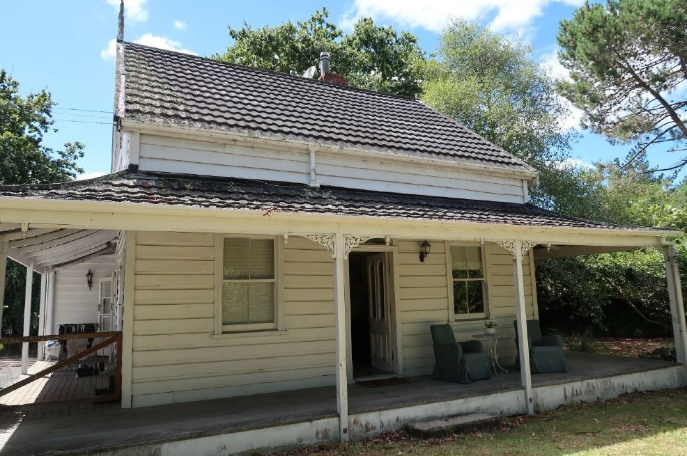
While Smedley may have temporarily continued gum digging in the Dargaville area immediately after acquiring his property it is likely he moved permanently to the holding in 1894 after getting married. Smedley appears to have built a simple initial one and half storey residence in the south eastern part of the leased land with assistance from Mary’s brother Charlie Hayward, and their brothers-in-law, Frank Christopher Hilford and Harry Hilford, who were married to Mary’s sisters. The building was a wide gable cottage with four rooms downstairs and further rooms on the upper floor accessed by a central ladder. The residence was constructed from local kauri timber, likely from the Coulthard Mill, and had twelve pane windows, a corrugated iron roof and was oriented to look westwards over the main part of the property and towards Maungakaramea. The building combined use as a family home with commercial functions and its role as the centrepiece of a burgeoning farm. Smedley appears to have steadily worked to clear and convert the fern covered land into farmland. By 1900, the property was described as being good land with 45 acres of ‘splendid black soil’ and several paddocks which were ‘ploughed and in grass’. Assisted by the close proximity of the wharf, however, the main focus of his activities remained connected with the gum trade. By 1898 Smedley was operating a gum business, store and boarding house from his residence capitalising on the improving economic situation as the country emerged from the Long Depression, and the last burst of activity in the extractive timber and gum digging industries in the North before the resources were exhausted. Smedley provided food, goods and accommodation to itinerant workers and purchased gum for export to Auckland and onto the international market. Smedley also actively recruited gum diggers for private fields as an agent acting for other local settlers. By 1900 Smedley had an annual turnover of £1500-£2000 from his businesses. Store accommodation was common through Northland and was a downmarket option in contrast to farmhouse accommodation or hotels. In 1899, only a few years after original construction, Smedley took out a mortgage on the leased property and appears to have invested in improvements to the residence which as well as improving the quality of accommodation on offer, created a more impressive farmhouse commensurate with the improved property. 
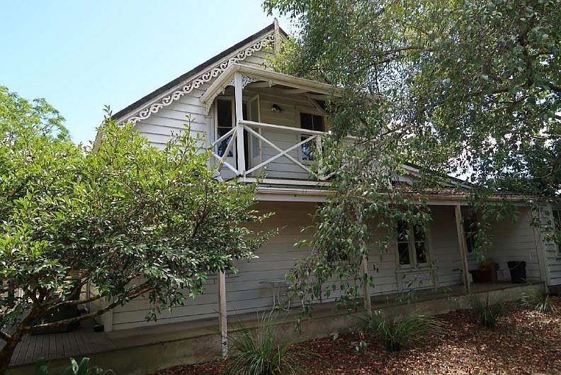
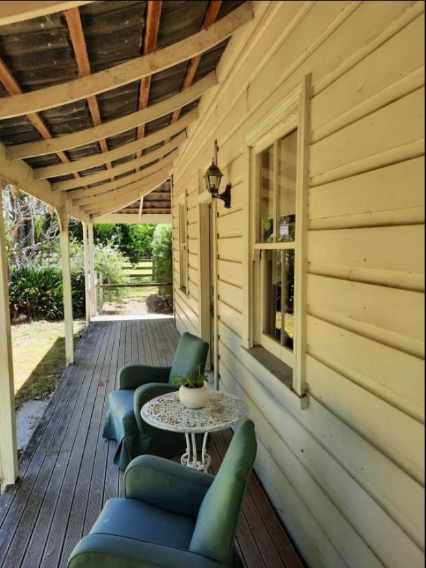
The improvements were reminiscent of the houses of wealthy landowners in nearby settlements, such as Clarke Homestead in Maunu, a large villa style residence built for Dr Alexander Clark in circa 1885, and projected the affluence the Smedleys aspired to. The residence was expanded with a lean-to on the back facing the wharf, while a wraparound verandah and balcony were added to the sides of the building which looked over the bulk of the farm and were visible from the road to Maungakaramea. Decorative elements were added to the house including timber fretwork and chamfered verandah posts, curved verandah and balcony rafters, a section of rusticated weatherboards on the west elevation around the front door, four-pane sash windows, and French doors. The internal layout was also changed with the addition of a staircase to the upstairs rooms and access to the new verandah from three rooms via French doors. The residence was described as nearly new with ten rooms and had a separate bathroom in an outbuilding. In July 1900 Smedley advertised the residence and wider property for sale and it was purchased in 1901 by Frank Hilford, one of the original builders of the house, who later acquired the freehold in 1910. With its sale, its use as a store and boarding house ceased. Ongoing use as a farmhouse (1901-1975) Smedley Farmhouse (Former) remained the primary residence for a small farm for most of the twentieth century. The residence generally retained its overall form and appearance throughout this period and subsequently. As extractive industries exhausted their potential, including the increased scarcity of kauri by 1905, settlers shifted to renewable industry including farming. During a period of tightening connections between New Zealand and Britain identified by historian James Belich as recolonisation, the number of small farms around New Zealand increased 30-fold between 1890 and 1911, largely on the back of protein farming of sheep, cattle and dairy for refrigerated export to Britain. Hilford and his wider family were established sheep and dairy farmers at Waikiekie and initially Hilford moved his existing sheep stock to his new farm. Hilford stopped sheep farming by April 1905 and, with the construction of cattle yards at Maungakaramea Wharf in circa 1904, likely shifted to cattle farming like other local farmers. Regular export of produce for the national and international market continued to be vital for the success of rural communities and the mosquito fleet continued to regularly visit Maungakaramea wharf. By the early twentieth century the Northern Steamship Company ran two services per week to the wharf and in 1906 Hilford was appointed to collect export dues from other local farmers. The subsequent owner of the farm, John Crane temporarily held the role until Hilford’s successor could be appointed. The Hilfords also established an orchard in the paddock immediately north of the residence growing fruit including pears, nectarines and quinces. In February 1912 a post office, initially known as Mangapai Wharf Post Office, was opened and run from one of the back rooms in the lean-to. In this fashion the residence continued to have a public role in the rural community despite primarily being a farm. Early mail deliveries to the area were by boat, although mail was likely brought by rail and road later in the century. In 1913 the name Oakleigh came to be associated with the community and the post office and wharf were officially renamed in 1913 and 1916 respectively. Oakleigh Post Office continued to be run from the residence by successive owners until its closure in 1945. For a short period of time from the mid-1910s Smedley Farmhouse (Former) was located immediately beside the the terminus of the North Auckland Railway which extended the continuous railway from Auckland to Oakleigh by 1916. A portion of the farm along the southern and eastern boundary was taken for the railway and Oakleigh station was built between the farmhouse and the wharf. The wharf remained an important shipping connection to Whangārei and farther north until the early 1920s when a further extension fully connected the line directly to Whangārei by rail thus diminishing the importance of Oakleigh within the North Auckland transport network. Hilford unsuccessfully attempted to take advantage of the proximity of the terminus and had a number of residential lots surveyed and subdivided in 1916 in the north eastern part of the farm. After selling Smedley Farmhouse (Former) with the western portion of the farm in 1917, Hilford retained the subdivision until 1922 when, with the railway extension completed, he sold them as a block that was later largely reintegrated into the rest of farm from 1928. Membership of farming and rural organisations was an important way in which farming communities remained connected. Hilford was an active member of the Mangapai Riding Farmers Association for many years and was elected onto the committee multiple times between 1906, and 1914 while he farmed the property. Between 1908 and 1911 Hilford also served as a councillor on the Whangarei County Council. From 1928 to 1949 the farm was owned by Lucy Nutsford with her husband George Frederick Ernest Nutsford, a farmer and former motor garage and taxi proprietor, who had previously lived in Whangārei. Lucy Nutsford developed a praised flower garden around the residence which became known as Nutsford Cottage. She was involved in women’s organisations including the Women’s Institute and the Whangarei Ladies’ Gardening Club and often hosted both groups in the residence and garden. The Nutsfords were relatively well-to-do and hosted parties for friends who motored to Oakleigh from Whangārei, and Nutsford also on occasion drove to Auckland. As the roading network north of Auckland improved over the twentieth century Smedley Farmhouse (Former) continued to be at the nexus of transport routes as the main road north passed to the west of the place. The intersection of the road and railway, immediately beside the driveway south west of the residence, was a dangerous section of road and the key for a roadside first aid kit was kept at the farmhouse in case of accidents. In 1938 the road was raised on a bridge over the railway. The road has been realigned over subsequent decades including extending the road surface at the height of the bridge past the residence which cut off the view of the western half of the farm from the residence in the early twenty-first century. Later changes to Smedley Farmhouse (Former) From 1928 Smedley’s farm mostly remained in the same ownership as a working farm. In 1968 and 1979 much of the property was sold although the orchard and residence remained as a single property. By 1942 a driveway had been formed along the southern boundary which later became a limited access road from the State Highway. After the road was subsequently raised the driveway was extended around the west boundary. With the changes to the grounds the main entrance to the house changed to the lean-to. The residence has had minor alterations to its internal configuration with changes limited to creating internal bathrooms, combining rooms into a larger room, and enclosing two sections of the back verandah. The residence was reblocked in the 1970s and re-piled since 2005 along with some additional repairs. In 2021 the place remains a private residence.
Context Smedley Farmhouse (Former) is located at Oakleigh, south of Whangārei, on a flat plain by the northern branch of the Mangapai River. The area is predominantly rural with a number of late twentieth and early twenty-first century residences in the surrounding landscape, including two residences constructed after 2004 immediately north of the place. A circa 1900 residence associated with an 1891 sawmill is located to the southwest of Smedley Farmhouse (Former). The place lies between the junction of multiple transport networks. The place is bounded by State Highway One on the west side and the North Auckland Railway Line runs past the southern and eastern boundary. A limited access road which comprises the former driveway is located by the south west corner. Immediately east of the railway line is the former railway station, clear of buildings with an unpaved gravel section, and the nineteenth century landing reserve with a twentieth century wharf. Site The Smedley Farmhouse (Former) site is generally rectangular, tapered at the south end. The site is comprised of a two-phase residence in the southern half, a grassed paddock, a former early twentieth century orchard with sheep in the northern half, and a driveway which runs along the western boundary around the south and east of the residence with an inner picket fence. A two-car garage with weatherboard cladding and a corrugated iron roof is located at the end of the driveway with a water tank behind. The west boundary includes a stone retaining wall associated with the raising of the road. Landscaping around the residence includes a raised garden within a picket fence in front of the residence separated by a path from a second garden. A paved area on the north side of the residence, with a hedge screening the paddock, is externally accessible via a path formed of railway sleepers. The remainder of the site immediately surrounding the residence is in grass with a number of mature trees including oak trees, a cabbage tree and a jacaranda. The paddock is lined by trees on the north and east sides. Residence The good quality, solidly built kauri timber residence was created in two early phases - an 1894 cottage and a circa 1900 extension with decorative villa elements – with minor subsequent alterations. The residence remains largely intact with its slight L-shaped plan and layout generally maintained with minor alterations to combine rooms to form a larger space. A number of early features have been retained since the residence was created by its first owner. Exterior The structure consists of an initial one and a half storey wide gable cottage with a lean-to on its east side. The structure also features a wraparound verandah on the north, west and south elevations and a small balcony in the southern gable. The main roof gable is orientated north to south over the 1894 building and extends at the lower pitch over the lean-to. The verandah roof has a slight concave shape with curved rafters. A concrete slab verandah deck has been covered with a timber deck. Two sections of verandah on the east elevation are enclosed with an extended verandah roof between. The residence is generally clad with plain weatherboards and all the roofs are tiled with decramastic tiles. At the join of the original structure and the lean-to on the south side is a visible break in the weatherboards which shows the connection of the separate elements. The original front elevation retains many of the villa decorative features which were added in 1900. These include rusticated weatherboards, timber fretwork brackets around the verandah posts, and a central four-panel glazed door, with a later rectangular fan-light above. Further fretwork brackets have survived on the south elevation at both verandah and balcony level and the later also retains its original chamfered posts and railing. Each gable has fretwork bargeboards and a tall finial is present on the north gable. Most of the windows are four pane sash windows with moulded architraves excepting the north elevation which retains earlier four twelve pane windows – two sash windows in the lean-to and two hinged in north gable – and the south elevation which has a pair of two pane sash windows with a prominent sill that evidently are a later twentieth century replacement of a doorway. A modern dormer window has been added in the east side of the roof. A pair of French doors with moulded details are located in the balcony and two further sets of French doors with plain architraves are present on the north side, opening onto the wraparound verandah. The original twelve pane rear entrance door has been relocated to the southern enclosed verandah room and a twenty-first century front door added. Interior The ground floor contains a kitchen and bathroom in the lean-to, an expanded dining room, a sitting room, and two bedrooms at the rear, and a laundry in the enclosed section of verandah. The dining room and bedrooms maintain external access onto the verandah and paved patio. A back-to-back fireplace is located on the shared wall between the sitting room and south bedroom. The bedroom fireplace has a cast iron grate and surround and decorative timber mantle which likely dates from the late nineteenth century. A modern woodburner with simple plaster surround is installed in the sitting room. The floors are mainly tongue and groove kauri timber and the door architraves and skirting boards are moulded. The ceilings are board and batten except in the renovated bathroom and are generally orientated east to west in the 1894 structure and north to south in the lean-to. The staircase, likely added during the circa 1900 alterations, is centrally located entirely within the 1894 structure facing the main entrance from the lean-to. The staircase has acoustic lining and ceiling tiles. Upstairs the rooms are arranged around a central north-south passage with the largest bedroom in the southwest corner. The room, through which the balcony is accessed, has a board and batten ceiling which extends into the passage while the other rooms have plastered ceilings. The rooms have sloped ceilings to collar height with exposed kauri beams except the northeast bathroom which has a dormer window on the east side with a view overlooking the landing reserve towards Mangapai River. A trapdoor covering the original ladder opening is located in the south east room. Large kauri rafters are visible in the roof space and a layer of earlier corrugated iron roofing is present beneath the external roof tiles.
Public NZAA Number
Q07/1480
Completion Date
2nd February 2021
Report Written By
Alexandra Foster
Information Sources
Keene, 1978
Keene, Florence, Legacies in Kauri: Old Homes and Churches of the North, Whangarei, 1978
Keene, 1978
Keene, Florence, Legacies in Kauri: Old Homes and Churches of the North, Whangarei, 1978
O'Shea, Bethany 1985
'Maungakaramea Past & Present' Maungakaramea Reserve Board 1985
O'Shea, Bethany 1985
'Maungakaramea Past & Present' Maungakaramea Reserve Board 1985
Stephen, 1983
Stephen, J.T., Early Northland: Waikiekie Pioneers 1860-1900 and their Descendants, Whangārei, 1983, pp. 102-3.
The Maungakaramea and Mangapai Wharves
‘The Maungakaramea and Mangapai Wharves’, in ‘UF018 Scrapbook’, Whangārei Recollect, Whangārei District Library, URL: https://whangarei.recollect.co.nz/nodes/view/2087?highlights=WyJvYWtsZWlnaCkiLCJvYWt0ZWlnaCwiLCJvYWsxZWlnaC4iLCJvYWtsZWlnaCJd&keywords=Oakleigh#idx24153
Report Written By
A fully referenced New Zealand Heritage List report is available on request from the Northland Area Office of Heritage New Zealand Pouhere Taonga
Current Usages
Uses: Accommodation
Specific Usage: Garden - private
Uses: Accommodation
Specific Usage: House
Uses: Agriculture
Specific Usage: Orchard
Former Usages
General Usage:: Accommodation
Specific Usage: Boarding/ Guest House
General Usage:: Agriculture
Specific Usage: Farm
General Usage:: Agriculture
Specific Usage: Paddock
General Usage:: Communication
Specific Usage: Post Office
General Usage:: Trade
Specific Usage: Trading station