

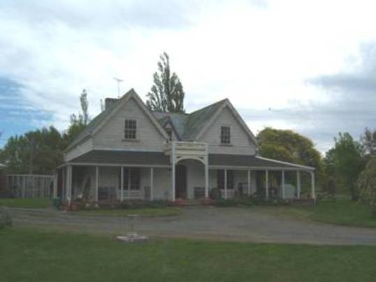
Godfrey carried out landscaping of the property, planting trees that remain to this day, and initially utilised a ditch and bank system in lieu of fencing to contain stock. By the early 1850s Godfrey had constructed a six roomed cob house, and nearby were cob stables which contained rooms for employees at one end. A separate cob building, with a wide verandah and steeply pitched hip roof was built to the south of the main cob house. Another cob building was near the banks of Mill Stream and may have been associated with blacksmithing. By the mid 1850s Godfrey established a water powered flourmill on the stream meandering through his property, this being the first flourmill established in Marlborough. In 1862 a large two storeyed timber house with wide verandah was constructed on the property some 500 metres south of the original cob house and the Godfreys' shifted into this with their growing family.
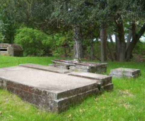
Remnants of many of these earliest structures survive. The timber homestead is easily recognisable as the large mid nineteenth century homestead erected by Godfrey despite having undergone some alteration and addition over time. Further to the north is the cob stable building as well as ruins of two cob buildings, a lined well and concrete horse trough. The mill dam wall and retaining wall of the mid 1850s survives largely intact, and some movable chattels from the mill, such as small parts of the waterwheel and cast iron machinery parts survive. The original timber mill building itself is no longer extant, as it was demolished in the late 1940s after having earlier been relocated to near the cob stables building and used as a woolshed. Foundations of a miller's house and a sheep dip survive downstream from the dam.
Only three families have held ownership since Woodbourne Farm was first established in the late 1840s: the Godfreys (1840s-1907), the Fairhalls (1907-1946) and the present owners, the Walsh family (from 1946). An interesting series of aviation and military events occurred at the property in the first half of the twentieth century, during the Fairhall family's time. Marlborough Aero Club began using part of the property for a flying field, and in October 1928 Charles Kingsford Smith used these paddocks for his return to Australia in the 'Southern Cross', the first flight made from New Zealand to Australia. The government leased the property from the Fairhalls during the Second World War to create a satellite air training and defence station called RNZAF Fairhall. During this time, pilot officers lived in the timber homestead and purpose-built defence structures were erected around the plantation and farm buildings. Nissen hangars or 'pens' were built for aircraft, three being erected on and near the site of the original six roomed cob homestead. A temporary dining hall and a separate concrete safe were constructed to the east of the timber homestead, in the 'forest' area beside Mill Stream. Remnants of these survive along with one of the original 15 Nissen hangars.
Woodbourne Homestead and Historic Farm forms a special historic place, with layers of history told through its combination of early plantings, archaeological features, chattels and its collection of structures and ruins. Both the dam walls associated with Marlborough's earliest flourmill and the Nissen hangar are rare survivors, the latter being a tangible reminder of a period of intense military and social activity at the property during the Second World War.
List Entry Information
Status
Listed
List Entry Status
Historic Place Category 1
Access
Private/No Public Access
List Number
1539
Date Entered
30th April 2010
Date of Effect
30th April 2010
City/District Council
Marlborough District
Region
Marlborough Region
Extent of List Entry
Extent includes the land described as Part Deposited Plan 420, (RT MB4D/485), Marlborough Land District and the buildings and structures associated with Woodbourne farm thereon, and its fittings and fixtures and the following chattels: Parts of seven blade windmill; parts of timber waterwheel; parts of cast iron mill machinery; flourmilling grindstones; and Gray plough (Refer to map in Appendix 1 of the registration report for further information). Key elements on the property that make up the historic place registration are: the two storeyed timber house known as Woodbourne Homestead, constructed in 1862 and altered over time; a set of double hinged cast iron gates; the structure of the mid nineteenth century landscaping, including the so-called 'forest', ditch and bank fencing and dray tracks; masonry and concrete dam wall and associated retaining wall, being the built remains of the mill dam of the early 1850s, all located at Mill Stream; cob stables of the 1850s that are still standing though much altered to function now as a shed; the remains of a cob building; a mid nineteenth century stone lined well near these cob remains; remains of a cob building located close to Mill Stream; remains of a sheep dip; foundation remains of miller's house; a 361 foot (110 metre) deep well to the south-west of the timber homestead; concrete horse trough; remnants of the Second World War defence structures including a rare surviving Nissen hangar, remnants of dining hall, concrete food safe, 'foxhole' ditches; archaeological features from all periods. Chattels included in the registration are parts of the timber waterwheel, cast iron mill machinery pieces, an almost complete iron turbine windmill associated with the stone lined well; flourmilling grindstones and a single furrow Gray plough.
Legal description
Pt DP 420, (RT MB4D/485), Marlborough Land District.
Location Description
A memorial marker with inscription, incorporating reused parts from the original mill from the site is situated on New Renwick Road, at the entrance to the long driveway leading down to the Woodbourne Homestead.
Why is this place significant?
Cultural Significance
Social Significance or Value Woodbourne Homestead and Historic Farm has considerable social significance. Henry Godfrey is notable as one of the few early landholders who actually lived and ran the farm at Woodbourne rather than merely owning it and living elsewhere. When his wife, Eliza, moved to the property in 1852 she was at that time one of only a very small number of Pakeha women in the Wairau. Like many settler women of the time, she learned to cope with unknowns, and her life revolved around family and social considerations, improving the house, managing servants and gardens. Woodbourne, with its relatively central location, became known as a social centre and it was here that several early settlers met their future spouses. The Godfreys' management of the property, including the employment of three married men and their families living in cottages on the farm, and payment of others (including local Maori) at harvest time, tells stories of social interactions typical of such labour intensive operations. The loss of the Godfrey's first child through illness reflects a reality that many did not live through infancy, and the subsequent death of Henry Godfrey and three of the Godfreys' children to diphtheria in 1868 showed the impact such an epidemic had on the community. Eliza, like so many people of the time, stoically carried on, giving birth to the Godfreys' last born after Henry's death, and being involved in the farm and mill's affairs. The cluster of trees called 'the forest' and its surrounds has had a range of uses by others in the community, especially in the twentieth century, ranging from camps of mounted rifles in the 1930s, to Second World War military camps between 1941 and 1943, to Scout Jamborees in the 1950s and 1960s. There have been numerous visits to the property by groups of different tree enthusiasts, such as the Wairau Plains Landscape Group. Field trips have also been conducted by the Marlborough Historical Society and the NZHPT.
Historic Significance
Historical Significance or Value Woodbourne Homestead and Historic Farm has historical significance that reflects the region's early settler history, agricultural and pastoral history, early twentieth century aviation history and Second World War military history. The range of buildings, structures and features including notable early landscaping at the property are significant in representing not only the requirements of a mid nineteenth century farm and commercial flour mill, but complementary layers of history associated with the site. This includes an interesting series of aviation and military events that occurred at the property in the first half of the twentieth century, ranging from the use by New Zealand's first aero club, Charles Kingsford-Smith's particularly significant trans-Tasman flight from New Zealand to Australia, to Second World War satellite air training. Although little tangible built heritage survives from these aviation and military ventures, documentation including photographs and a few key pieces of built heritage survive to tell the story of this brief but intense series of events at the property. Woodbourne Homestead and Historic Farm therefore has additional historical significance as a reminder of a particular period in New Zealand history, the Second World War when the threat of enemy attack was genuinely feared.
Physical Significance
Aesthetic Significance or Value Woodbourne Homestead and Historic Farm has aesthetic value. As a group, the homestead, farm buildings and ruins including the dam, set in a rural landscape with well established and noteworthy historic plantings, has aesthetic value as a rustic example of an early settler farm. As a complex the place holds strong community meaning which gives a real sense of place of the working farm and mill, something which has been captured by both owners of and visitors to the place in photographs and paintings over the years. Archaeological Significance or Value Pre-1900 buildings, ruins and other structures including sheep dip and stone-lined well, garden structure, earthworks including the early ditch and bank system and dray tracks, and artefacts together combine to give the place archaeological significance. In addition, there is reasonable cause to suspect that the grounds of the property, especially the sites of nineteenth century structures that are no longer extant (for example, Godfrey's first cob hut or whare, the mill building, miller's house, original cob homestead, gig house) may hold archaeological material. The archaeology of the place therefore can contribute knowledge at a regional level to enhance an understanding more of the lives of the Godfreys' and their staff and of how the early farm operated. Features associated with the Second World War such as the military camp site, sites of Nissen hangars and foxholes may also be considered to have archaeological value as they are able to provide evidence relating to the historical and cultural heritage of New Zealand through investigation by archaeological methods. Architectural Significance or Value As a group the early farm structures, including the cob building remains, dam walls and associated retaining wall, and the timber homestead hold architectural value. Cob houses and buildings were a major feature in New Zealand vernacular architecture, as cob was an ideal construction material, but relatively few such buildings survive. In addition, the Nissen hangar has architectural significance as a rare survivor of the building type that was once very common and its ongoing use to hold farm implements demonstrates the flexibility of such structures for adaptation to a range of uses.
Why is this place Category 1 / Category 2?
Detail Of Assessed Criteria
(a) The extent to which the place reflects important or representative aspects of New Zealand history The complex, including the 1862 Woodbourne Homestead, is largely representative of early sheep farms in Marlborough, integral to the story of the pattern of settlement in New Zealand. As a group, the buildings and structures form a good representative example of this type in New Zealand. The mill dam represents an important aspect of New Zealand's history, being the first flourmill in Marlborough to supply flour, removing the necessity to import it to the region from Australia. (b) The association of the place with events, persons, or ideas of importance in New Zealand history Woodbourne Homestead and Historic Farm is strongly associated with Henry Godfrey, a pioneer early squatter who had arrived in Nelson in late 1842 and who in the 1850s and early 1860s took the property to the point of being widely recognised as a model farm. As well as being active on the farm, Henry Godfrey had taken a lively interest in politics and had variously been Deputy-Superintendent of the Marlborough Province, Member of the Executive, Justice of the Peace, Member of the Nelson Provincial Council and an active worker on several local committees. Godfrey's death (and the death of three of his children) from diphtheria reflects a true epidemic that swept through Marlborough in the late 1860s resulting in many deaths. The property is also closely associated with aviation events of importance in New Zealand, notably the flight of Charles Kingsford Smith from the paddocks of Woodbourne back to Australia following the first non-stop aerial crossing of the Tasman Sea in 1928. The return flight from Woodbourne was the first flight made from New Zealand to Australia. Woodbourne Homestead and Historic Farm saw an intense period of military activity between 1941 and 1943, when it became a satellite aviation training and defence base during the Second World War, a pivotal period in New Zealand's history when the threat of attack was considered very real. (e) The community association with, or public esteem for the place Woodbourne farm is a well-known farm in the Wairau Valley. The property has been made open to the public on numerous occasions and the farm has been mentioned in several publications. There is a strong community association for Woodbourne farm generally, and its grounds have been used for a host of community activities in the twentieth century, ranging from biannual mounted rifle camps, scout jamborees and vintage farm machinery shows. An unveiling of the memorial at the entrance in the 1960s was attended by a large crowd. (j) The importance of identifying rare types of historic places The cob structures and chattels such as the remains of the waterwheel and windmill have historical significance as a tangible reminder of a type of building construction and machinery often used by pioneer settlers but now relatively rare. The Nissen aircraft hangar is the only one left out of 15 originally on the Woodbourne property during the Second World War. Nissen huts were often used in many countries because they were cheap, quickly built and versatile. That many were erected at Woodbourne during the Second World War is not surprising, but the fact that one survives there in situ is particularly rare. The Woodbourne one is believed to be one of only four in situ in New Zealand, the other three being at Ashburton Aerodrome and Ardmore Aerodrome. Conclusion It is considered that this place qualifies as a Category I historic place. Woodbourne Homestead and Historic Farm historic place forms a special cultural landscape with its layers of history that tells the stories of early settler history from the 1840s, farming history including that of mid nineteenth century systematic commercial agriculture, early twentieth century aviation history and Second World War military history. As the site of a range of pioneering ventures, the collection of surviving structures and features combined with intangible social histories indicate that the place is of special significance.
Construction Details
Type
Original Construction
Description
Landscaping, Cob buildings, Flourmill including dam walls and retaining wall.
Period
1850s
Start Year
1862
Type
Original Construction
Description
Woodbourne Homestead (timber house)
Start Year
1900
Type
Original Construction
Description
Well
Start Year
1928
Type
Original Construction
Description
Concrete horse trough
Start Year
1942
startYearCirca
Type
Original Construction
Description
Nissen hangar, concrete food safe, dining hall
Construction Materials
Variously cob, timber, glass, corrugated iron, cast iron, concrete, cement, brick.
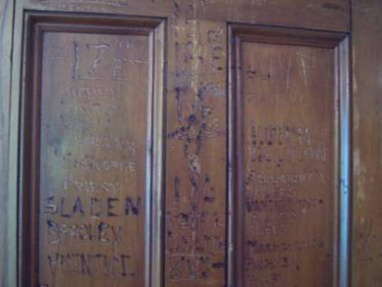
The Wairau Valley is a wide river valley with rolling hills in the upper valley, opening onto the Wairau Plain, where Renwick and Blenheim are situated. The general area around Renwick was a favoured place for Maori cultivating food plants and there were a number of scattered hamlets or families dotted about the surrounding area. Several waterways, including Mill Stream and Fairhall River, drained into an extensive lagoon that teemed with swamp and water fowl. The farm property known as Woodbourne was established by Henry Godfrey, who had been among the first pastoralists and agriculturalists in the Wairau area. Henry Godfrey arrived in Nelson in December 1842 on the George Fyfe, a ship chartered by the New Zealand Company. Little is known about Godfrey's first five years in the new settlement, but it appears that by 1846 he was squatting on an area of land approximately 3,000 acres in the Wairau which was later to become known as Woodbourne. By 1847 he was weighing up whether to build a house on some land in his possession but plans were put on hold. It appears Godfrey then went to China and back to England then returned to Nelson by 1848 when the survey of the Wairau was being completed and licenses were granted to section holders. Elizabeth W Godfrey (Henry's mother) is noted as the original section holder for section 75 in 1848 though no section holders appear to be named at this date for section 76, the core of the existing historic farm. Henry Godfrey appears to have formally acquired a license for the land by 1850 and ultimately gained ownership through a Crown Grant process beginning in 1852. Over the following few years, Godfrey purchased several of the bordering blocks and by 1858 he had approximately 600 acres in one block. Henry Godfrey retained interests in Nelson and also held interests in the Awatere Valley where, from circa 1850, he had a lease over 7,000 acres (known in the New Zealand Company records as Fairfield Downs, and now known as Camden). Because of his extensive travelling, Godfrey chose his centrally placed property near Renwick to be his main base and by the early 1850s he had built a cob hut or whare there. Godfrey named this farm 'Woodbourne', purportedly after the Godfrey family home in Oxford, though various spellings have been used over time. Other cob buildings were soon built on the property including the first proper homestead which was constructed in time for Godfrey's marriage in 1852 to Eliza Jane Harley, another early Nelson settler, who moved with Godfrey to his property in the Wairau immediately after their marriage. Land records show that in 1852 Charles Harley, Eliza's father, was granted 150 acres being Rural Section 73 in the District of Omaka, this being part of the land that Godfrey added to his farm. Eliza, one of only eight Pakeha women in the Wairau, contributes to an important story of pioneer women. Her memoirs and letters record journeying with some anticipation to the residence in the Wairau and graciously coping with many unknowns. Like many settler women of the time, her life revolved around family and social considerations, cooking, improving the house, and managing servants and gardens. The cob house that Henry and Eliza lived in was a six roomed cottage, with small bedrooms and sitting room, and with a kitchen 'of a good size'. Although she had household help, like many colonial women, Eliza actively participated in work, baking bread and learning to make butter, cheese, cornflour and haggis. The surrounds were well established by 1852 when Eliza arrived, with a garden with fruit trees and four gums (planted from seed sent from Australia), together with a cultivated five acre paddock. Nearby was a four-stalled cob stable, with two rooms at the end for men to sleep and smoke in. There was also a shearing shed and stockyard. To the south of the cob homestead a stone lined well was put down. Near to this was a cob building with a steeply pitched hip roof, the function of which is not certain. It may have been use for accommodation or as a second set of stables, or possibly it was the shearing shed referred to by Eliza Godfrey in her memoirs. These early buildings and early landscaping were established on Section 76, a parcel of land which Godfrey appears yet to have officially purchased through the Crown Grant process. To contain the property, Godfrey paid workers to follow his specifications to create a ditch and bank system around parts of the property in lieu of fences. Hawthorne or 'prick' hedges were planted atop the banks. Later, Godfrey became the first in the district to erect iron standard and steel wire fencing. By the mid 1850s Godfrey established a flourmill, powered by a breast waterwheel, on the stream meandering through his property. Believed to have been built by John Barton, this was the first flour and grist mill established in Marlborough. The erection of the mill meant that the wheat, barley and oats could be milled directly. It was timely, not only for local residents and the Godfrey family but because the Wakamarina gold rush of the 1860s provided a ready business for Godfrey's Marlborough Mill. There were teething issues especially with the first set of mill stones as further had to be imported from England. By 10 January 1857 the farm was harvesting a large field of oats for processing in the small flourmill driven by water power. At times when the water level in the Mill Stream became too low to operate the water wheel, Godfrey used a steam engine to run the mill, being the first in the district to utilise such machinery. Godfrey's farm journal entries record aspects of the flourmill, dam and harvest. The mill house, a timber building, may have cantilevered over the river, as Godfrey's journal records flood waters of Mill Stream coming up over the floor of the mill house. Godfrey's cash book shows he made payments for some 'Maoris' who helped at harvest time. By 1858, Godfrey had brought Woodbourne to the stage where it was described as a 'model farm' and even strangers would come to see it. He was the first local farmer to purchase and use machines for harvesting. The farm had a swim-through sheep dip, a necessity for such properties running flocks of sheep in the mid nineteenth century. Numerous Wairau sheep runs suffered from the serious issue of 'scab', the sheep disease that eventually led to ruin for many in the region. Many sheep imported from eastern Australia between the 1840s and 1860s were infected with scab, and sheep dips were quickly installed to dip sheep immediately after shearing. In 1860 Godfrey decided to build a new timber house and engaged an architect, Mr Sloane. Carpenters came from Nelson, though it is not known who supplied the timber. Bricks used in construction were made on the farm. Slates for the roof and other fittings were imported from England. By 1863 the house (the present Woodbourne Homestead) was occupied by the Godfreys, though it had stretched their finances considerably. Nineteenth century photographs of the house show it as a substantial double gabled two storeyed structure with a trellised verandah running around the north and west sides, and with a large brick chimney on the south exterior. This chimney served the kitchen's bread oven, hot water boiler and cooker. The interior had walls of roughly dressed timber and scrim and in all there were seven fireplaces. Largely the domain of Eliza Godfrey, the logistics for running the household required attentive effort, not least to keep the fireplaces operating for heating, cooking and hot water. After the Godfreys shifted into the new timber homestead, George Story (head farm worker) and his family moved into the original cob homestead. In the early to mid 1860s Story left to establish his own farm and he was replaced at Woodbourne by George Graham. By this time, the farm was thriving, the mill was always working and there were three married men in cottages working on the property. Woodbourne, with its relatively central location, became known as a social centre and it was here that several early settlers met their future spouses. It was some time before proper roading was developed in the area and many travellers or farmers shifting stock simply crossed over the property. Horse and carts (gigs) appear to have come in over the stream to the north of the house. A gig house, with cobbled floors, was located several metres from the west of the timber homestead. Sadly, Godfrey did not live long to enjoy his new homestead, as he died from diphtheria at age 42 on 22 August 1868. A true epidemic that swept through the district, diphtheria also claimed the lives of three of the Godfrey children in the homestead. Godfrey's obituary noted his vast contribution to the new colony. An early settler, he successfully followed the pursuits of sheep farmer, agriculturalist and miller and he is noted as being the first to introduce the use of steam in this district, and one of the first in New Zealand. Godfrey had taken a lively interest in politics and had variously been Deputy-Superintendent of the Marlborough Province, Member of the Executive, Justice of the Peace, Member of the Nelson Provincial Council and an active worker on several local committees. After Godfrey's death, the farm was vested in trustees, and Eliza, who was pregnant when the epidemic swept through the household, stayed on to give birth to their lastborn, Ethel. Then Eliza and family moved to Nelson for a period of 15 months in an effort to improve her spirits, before returning to live at the farm for about four years with the children. The farm continued to be run by manager, George Graham, who knew the farm and mill operations well. Eliza was involved in the farm and mill's affairs, nevertheless, and after her husband's death, invoices for flour from the Marlborough Mill were debtor to Mrs H Godfrey. In 1874 Eliza and children left Woodbourne for good and the property was leased to the Redwoods and Fairhalls. In November 1878 Eliza Godfrey remarried, this time to Evan Prichard, a chemist of Nelson, though he too died an untimely death just over one year later, in early 1880. An advertisement for leasing in 1884 gives an indication of what was at the farm: 'The property consists of sections 72, 73, 74, 75, 76, and parts of 78, 90, 92, 94, all freehold, and section 89 leasehold, running to November 1888. Substantial house of eleven rooms, and Cellar, and Stables, and Orchard attached, Woolshed, Sheep Dip, three Cottages, Sheds, and Stables. Two thousand Sheep.' Small changes occurred at the property. It is not known when the corrugated iron was placed as roof covering on the verandah, as only slate tiles are mentioned in Eliza's memoirs of the early house. Photographs show that by the late nineteenth century, the verandah roof was striped in appearance, either because it was painted that way or possibly due to the method of creating corrugated iron in the nineteenth century whereby more zinc was used on the upside and less on the underside of the sheets. The use of corrugated iron during the nineteenth century often shows a striped appearance over time since, whether deliberate or not, the placing of sheets with the underside turned up meant that alternate sheets showed rusting. In 1900 a deep artesian well was put down close to the west side of the timber homestead. The well was astonishingly deep at 361 feet (110 metres) and was operated by a Douglas hand pump from within the house itself. It appears that some time before 1907 the timber mill house was shifted, by traction engine, about 250 metres north of its site by the dam walls to sit just south of the cob stables. In 1928 a concrete horse trough, surmounted by water tanks, was built near a present stone lined well. An interesting link with the Walsh family who later became owners, the horse trough was constructed by Irish immigrant, Dick Dermody, Mahon Walsh's uncle. In 1907 the Godfrey family finally sold the last of the Woodbourne estate to Edward Fairhall. An interesting series of aviation and military events occurred at the property, which at this time was often referred to as Fairhall's Farm, during the Fairhall family's time at Woodbourne. In the 1920s the Marlborough Aero Club, the first such club formed in New Zealand, began using an area of Woodbourne for a flying field. Charles Kingsford Smith used these large paddocks for his return to Australia in the 'Southern Cross' in 1928 following his historic first non-stop flight across the Tasman Sea to New Zealand. Kingsford Smith required a particularly long runway for take-off so fences were removed between paddocks to allow more than 200 acres for take-off. 'Smithy's' flight from Woodbourne to Sydney was made in 22 hours 51 minutes, nearly double the time it had taken him to cross eastward the first time. It was itself an historic event, being the first flight made from New Zealand to Australia. The decision to make the return trip from the Woodbourne property, near Blenheim, instead of Christchurch was made after it had been estimated that by avoiding the Southern Alps, the flying time would be reduced by about two hours. In 1935 a terminal building was built and used by Union Airways and Cook Strait Airways. As well as the aviation developments at the property, military camps had been held on the site. Between 1920 and 1930 the Nelson-Marlborough mounted rifles used the forest and large fields of Woodbourne as the site of regular camps. In 1936 there was a particularly large camp of these mounted rifles which drew huge crowds and the Governor General of the time attended. In 1939, at the start of the Second World War, the Government took part of Woodbourne, by proclamation, for defence and training purposes, and the area at the far north and north-east of the property became RNZAF Base Woodbourne, a permanent military base that remains to this day. The core of the Woodbourne (Fairhall) Farm was leased by the government to become a satellite station, Fairhall Satellite Aerodrome. Between August 1942 and June 1943 Airforce Fighter squadrons 14, 15, 16, 17 and 18 were based around the Woodbourne Homestead and farm site (RNZAF Fairhall). Fighter Squadron 16 was the first to arrive, the others following sometimes only for a short time as they prepared for operational tours in the Pacific. Here airmen trained for operational flying in the Pacific, whilst providing defence for the Wellington and Marlborough regions. A flying off strip was located to the north and west of Woodbourne Homestead. The airforce utilised some of the existing buildings on the farm. The pilot officers lived in the timber house, Woodbourne Homestead, as it became the officers' mess between 1942 and 1943. During this time the house saw an intense period of social activity, and it suffered considerable wear as a result. The predominant fighter squadron initially was the Sixteenth Fighter Squadron, but both the seventeenth and eighteenth fighter squadrons were also present for a time, as evidenced by the names of airmen from each of these three squadrons scratched on the living room door of the homestead. A 1940s photograph shows approximately sixteen little Japanese flags hanging from an upper window on the north elevation, representing 'kills' made by airmen while flying overseas. While some of the existing farm building were utilised by the airforce, some were altered or destroyed during this period. It appears that the original cob homestead built by Godfrey was flattened to make way for an aircraft maintenance hangar. The original miller's house, constructed of timber possibly in the 1860s, located about 70 metres north of the dam site and had in its latter years been used as a singlemen's quarters, was also demolished by the airforce. Many other temporary structures were constructed by the airforce on the farm, almost all being demolished after the Second World War, as was the arrangement between government and the Fairhalls. While pilot officers lived in the Woodbourne Homestead, others lived in huts amongst Godfrey's original tree plantation area (the 'forest'), as it provided natural camouflage. Other temporary buildings included fifteen timber-framed Nissen hangars for kittyhawk aircraft, a dining hall (dining mess), concrete food safe, a bridge to the east of the timber homestead, a new well, and 'foxholes' (military pits) on the north edge of the property. The Nissen hangars, also called Nissen huts, a commonly used type of simple half-barrel structure named after Canadian engineer Lt Col Peter N Nissen, were constructed around the property as hangars for the aircraft. Three of the Nissen hangars were situated at the northern end of the property, around Godfrey's original homestead site. While fourteen of the original fifteen Nissen hangars were demolished after the airmen left, one was allowed to remain and this survives to this day as one of only about four in New Zealand surviving in situ. This Nissen hangar, the design being a parabolic shelter and sometimes referred to as a blister hangar, was used during the Second World War as a maintenance hangar. Aeroplanes would be wheeled in through sliding doors on the east elevation and propped up to allow engine change. Documentation associated with the Fairhall Aerodrome refers to the Nissen hangars as 'pens', noting that some aircraft pens were covered only with netting (camouflage) while others were weatherproofed. In 1946 following the Second World War, G H M Fairhall Estate sold the core of the historic property to T M (Mahon) Walsh. Evan Fairhall retained the property (named Fairview) fronting Godfrey and Middle Renwick Road. Mahon Walsh and his family were interested in both the history of the property and expanding its farming pursuits. Even prior to ownership, the Walshs had a long association with the property, as Mahon's father and grandfather had worked on the farm. Mahon became a major grower of lucerne seed in the years 1950 to 1960, producing over 100 dressed sacks annually. In October 1959 a vintage farm machinery show was held at Woodbourne, a fitting venue since the fields there had been among the first in Marlborough to be cultivated utilising some of the first agricultural farm machinery in the district. Organised by the Marlborough District Federation of Young Farmers Clubs as part of the Marlborough Centennial year celebrations, this was the first show of vintage machinery to be held in Marlborough and one of the first in New Zealand. This vintage farm machinery show, recorded by photographer and historian Norman Brayshaw, was the catalyst for the creation of Brayshaw Heritage Park in Blenheim. During the 1950s and 1960s the 'forest' area was used for scout jamboree camps. In 1962 a memorial was erected by the New Renwick Road entrance to Woodbourne Farm, comprising components of Godfrey's Marlborough Mill and a plaque with a brief outline of the historic farm and mill. In 1973, part of the land was sold to Montana Wines and grape vines were planted. Mahon's son, John R Walsh, the present owner, who has lived his entire life on the property, with his wife, Lynne, became a pioneer deer farmer at Woodbourne in 1977. In 1989 John and Lynne Walsh and family planted their first grape vines, showing viticulture becoming a common trend in Marlborough. As with previous owners, a number of changes have occurred to the structures at the property since the Walshs took over. The timber Woodbourne Homestead has seen almost constant small-scale change. Almost immediately after purchasing the property, Mahon removed the slate tiles from the roof of the timber homestead, as they were in poor condition, and replaced them with reused corrugated iron taken from the cob building that is now in ruins near the well at the north end of the property. The verandah posts were replaced and gradually the verandah trellis has been removed. Chimneys were reduced in height in the 1970s. The chimney associated with the kitchen's bread oven and cooker was dismantled, and the original bread oven door was relocated for use as a wood box door for the log burner in the sitting room. Single storey additions have been built at the south-west and north-west corners of the house in stages from around the 1970s. The corrugated iron roofing of the verandah was replaced with decramastic style tiling in the 1980s. Some changes occurred near to the house. Mahon built a detached garage to the north-east of the house but this burnt down in 1998. The gig house several metres to the south-west was derelict, having been crushed by limbs of large trees in the area, and was demolished by Mahon. He then built a concrete tennis court in this area, covering over the deep well of 1900. In the late 1990s John Walsh pulled up the old tennis court and found the well, confirming that it is indeed of a significant depth. Also in the late 1990s, John Walsh built a single storeyed double garage a few metres to the north-east of the homestead to replace the one that had recently burnt down. By the time Mahon Walsh purchased the property in 1946, the defence department had either already removed most of the military buildings or was in the process of doing so. Mahon was eager to purchase and retain at least one of the Nissen hangars and he successfully negotiated with the Public Works Department for the retention of the Nissen hangar located immediately to the west of the stables. Mahon clad it with iron over the original malfoid covered plywood and used it as an implement shed. Nissen hut type buildings were commonly relocated or destroyed, but the survival of this parabolic shelter type of Nissen building (also known as a blister hangar) is believed now to be one of only four surviving in situ in New Zealand, the others being two at Ardmore Aerodrome and one at Ashburton Aerodrome. It is not clear if the relocated timber mill building had been used by the airforce, as it was derelict by the time the Walsh family took over the property in 1946, so Mahon burnt it down. A sheep yard and adjacent woolshed were built roughly on the site of another of the Nissen hangars, being the approximate site of Godfrey's original cob house. The present owner, John Walsh, collects vintage farm machinery, much of which does not originate from the property, although a number of implements are parts are from Woodbourne farm, such as remains of a seven blade windmill (which may date from the 1880s and was an addition to the early stone lined well), a single furrow Gray plough, and parts of the original flourmill machinery.
The Wairau Valley is a wide river valley with rolling hills in the upper valley, opening onto the Wairau Plain, where Renwick and Blenheim are situated. The general area around Renwick was a favoured place for Maori cultivating food plants and there were a number of scattered hamlets or families dotted about the surrounding area. Several waterways, including Mill Stream and Fairhall River, drained into an extensive lagoon that teemed with swamp and water fowl. The farm property known as Woodbourne was established by Henry Godfrey, who had been among the first pastoralists and agriculturalists in the Wairau area. Henry Godfrey arrived in Nelson in December 1842 on the George Fyfe, a ship chartered by the New Zealand Company. Little is known about Godfrey's first five years in the new settlement, but it appears that by 1846 he was squatting on an area of land approximately 3,000 acres in the Wairau which was later to become known as Woodbourne. By 1847 he was weighing up whether to build a house on some land in his possession but plans were put on hold. It appears Godfrey then went to China and back to England then returned to Nelson by 1848 when the survey of the Wairau was being completed and licenses were granted to section holders. Elizabeth W Godfrey (Henry's mother) is noted as the original section holder for section 75 in 1848 though no section holders appear to be named at this date for section 76, the core of the existing historic farm. Henry Godfrey appears to have formally acquired a license for the land by 1850 and ultimately gained ownership through a Crown Grant process beginning in 1852. Over the following few years, Godfrey purchased several of the bordering blocks and by 1858 he had approximately 600 acres in one block. Henry Godfrey retained interests in Nelson and also held interests in the Awatere Valley where, from circa 1850, he had a lease over 7,000 acres (known in the New Zealand Company records as Fairfield Downs, and now known as Camden). Because of his extensive travelling, Godfrey chose his centrally placed property near Renwick to be his main base and by the early 1850s he had built a cob hut or whare there. Godfrey named this farm 'Woodbourne', purportedly after the Godfrey family home in Oxford, though various spellings have been used over time. Other cob buildings were soon built on the property including the first proper homestead which was constructed in time for Godfrey's marriage in 1852 to Eliza Jane Harley, another early Nelson settler, who moved with Godfrey to his property in the Wairau immediately after their marriage. Land records show that in 1852 Charles Harley, Eliza's father, was granted 150 acres being Rural Section 73 in the District of Omaka, this being part of the land that Godfrey added to his farm. Eliza, one of only eight Pakeha women in the Wairau, contributes to an important story of pioneer women. Her memoirs and letters record journeying with some anticipation to the residence in the Wairau and graciously coping with many unknowns. Like many settler women of the time, her life revolved around family and social considerations, cooking, improving the house, and managing servants and gardens. The cob house that Henry and Eliza lived in was a six roomed cottage, with small bedrooms and sitting room, and with a kitchen 'of a good size'. Although she had household help, like many colonial women, Eliza actively participated in work, baking bread and learning to make butter, cheese, cornflour and haggis. The surrounds were well established by 1852 when Eliza arrived, with a garden with fruit trees and four gums (planted from seed sent from Australia), together with a cultivated five acre paddock. Nearby was a four-stalled cob stable, with two rooms at the end for men to sleep and smoke in. There was also a shearing shed and stockyard. To the south of the cob homestead a stone lined well was put down. Near to this was a cob building with a steeply pitched hip roof, the function of which is not certain. It may have been use for accommodation or as a second set of stables, or possibly it was the shearing shed referred to by Eliza Godfrey in her memoirs. These early buildings and early landscaping were established on Section 76, a parcel of land which Godfrey appears yet to have officially purchased through the Crown Grant process. To contain the property, Godfrey paid workers to follow his specifications to create a ditch and bank system around parts of the property in lieu of fences. Hawthorne or 'prick' hedges were planted atop the banks. Later, Godfrey became the first in the district to erect iron standard and steel wire fencing. By the mid 1850s Godfrey established a flourmill, powered by a breast waterwheel, on the stream meandering through his property. Believed to have been built by John Barton, this was the first flour and grist mill established in Marlborough. The erection of the mill meant that the wheat, barley and oats could be milled directly. It was timely, not only for local residents and the Godfrey family but because the Wakamarina gold rush of the 1860s provided a ready business for Godfrey's Marlborough Mill. There were teething issues especially with the first set of mill stones as further had to be imported from England. By 10 January 1857 the farm was harvesting a large field of oats for processing in the small flourmill driven by water power. At times when the water level in the Mill Stream became too low to operate the water wheel, Godfrey used a steam engine to run the mill, being the first in the district to utilise such machinery. Godfrey's farm journal entries record aspects of the flourmill, dam and harvest. The mill house, a timber building, may have cantilevered over the river, as Godfrey's journal records flood waters of Mill Stream coming up over the floor of the mill house. Godfrey's cash book shows he made payments for some 'Maoris' who helped at harvest time. By 1858, Godfrey had brought Woodbourne to the stage where it was described as a 'model farm' and even strangers would come to see it. He was the first local farmer to purchase and use machines for harvesting. The farm had a swim-through sheep dip, a necessity for such properties running flocks of sheep in the mid nineteenth century. Numerous Wairau sheep runs suffered from the serious issue of 'scab', the sheep disease that eventually led to ruin for many in the region. Many sheep imported from eastern Australia between the 1840s and 1860s were infected with scab, and sheep dips were quickly installed to dip sheep immediately after shearing. In 1860 Godfrey decided to build a new timber house and engaged an architect, Mr Sloane. Carpenters came from Nelson, though it is not known who supplied the timber. Bricks used in construction were made on the farm. Slates for the roof and other fittings were imported from England. By 1863 the house (the present Woodbourne Homestead) was occupied by the Godfreys, though it had stretched their finances considerably. Nineteenth century photographs of the house show it as a substantial double gabled two storeyed structure with a trellised verandah running around the north and west sides, and with a large brick chimney on the south exterior. This chimney served the kitchen's bread oven, hot water boiler and cooker. The interior had walls of roughly dressed timber and scrim and in all there were seven fireplaces. Largely the domain of Eliza Godfrey, the logistics for running the household required attentive effort, not least to keep the fireplaces operating for heating, cooking and hot water. After the Godfreys shifted into the new timber homestead, George Story (head farm worker) and his family moved into the original cob homestead. In the early to mid 1860s Story left to establish his own farm and he was replaced at Woodbourne by George Graham. By this time, the farm was thriving, the mill was always working and there were three married men in cottages working on the property. Woodbourne, with its relatively central location, became known as a social centre and it was here that several early settlers met their future spouses. It was some time before proper roading was developed in the area and many travellers or farmers shifting stock simply crossed over the property. Horse and carts (gigs) appear to have come in over the stream to the north of the house. A gig house, with cobbled floors, was located several metres from the west of the timber homestead. Sadly, Godfrey did not live long to enjoy his new homestead, as he died from diphtheria at age 42 on 22 August 1868. A true epidemic that swept through the district, diphtheria also claimed the lives of three of the Godfrey children in the homestead. Godfrey's obituary noted his vast contribution to the new colony. An early settler, he successfully followed the pursuits of sheep farmer, agriculturalist and miller and he is noted as being the first to introduce the use of steam in this district, and one of the first in New Zealand. Godfrey had taken a lively interest in politics and had variously been Deputy-Superintendent of the Marlborough Province, Member of the Executive, Justice of the Peace, Member of the Nelson Provincial Council and an active worker on several local committees. After Godfrey's death, the farm was vested in trustees, and Eliza, who was pregnant when the epidemic swept through the household, stayed on to give birth to their lastborn, Ethel. Then Eliza and family moved to Nelson for a period of 15 months in an effort to improve her spirits, before returning to live at the farm for about four years with the children. The farm continued to be run by manager, George Graham, who knew the farm and mill operations well. Eliza was involved in the farm and mill's affairs, nevertheless, and after her husband's death, invoices for flour from the Marlborough Mill were debtor to Mrs H Godfrey. In 1874 Eliza and children left Woodbourne for good and the property was leased to the Redwoods and Fairhalls. In November 1878 Eliza Godfrey remarried, this time to Evan Prichard, a chemist of Nelson, though he too died an untimely death just over one year later, in early 1880. An advertisement for leasing in 1884 gives an indication of what was at the farm: 'The property consists of sections 72, 73, 74, 75, 76, and parts of 78, 90, 92, 94, all freehold, and section 89 leasehold, running to November 1888. Substantial house of eleven rooms, and Cellar, and Stables, and Orchard attached, Woolshed, Sheep Dip, three Cottages, Sheds, and Stables. Two thousand Sheep.' Small changes occurred at the property. It is not known when the corrugated iron was placed as roof covering on the verandah, as only slate tiles are mentioned in Eliza's memoirs of the early house. Photographs show that by the late nineteenth century, the verandah roof was striped in appearance, either because it was painted that way or possibly due to the method of creating corrugated iron in the nineteenth century whereby more zinc was used on the upside and less on the underside of the sheets. The use of corrugated iron during the nineteenth century often shows a striped appearance over time since, whether deliberate or not, the placing of sheets with the underside turned up meant that alternate sheets showed rusting. In 1900 a deep artesian well was put down close to the west side of the timber homestead. The well was astonishingly deep at 361 feet (110 metres) and was operated by a Douglas hand pump from within the house itself. It appears that some time before 1907 the timber mill house was shifted, by traction engine, about 250 metres north of its site by the dam walls to sit just south of the cob stables. In 1928 a concrete horse trough, surmounted by water tanks, was built near a present stone lined well. An interesting link with the Walsh family who later became owners, the horse trough was constructed by Irish immigrant, Dick Dermody, Mahon Walsh's uncle. In 1907 the Godfrey family finally sold the last of the Woodbourne estate to Edward Fairhall. An interesting series of aviation and military events occurred at the property, which at this time was often referred to as Fairhall's Farm, during the Fairhall family's time at Woodbourne. In the 1920s the Marlborough Aero Club, the first such club formed in New Zealand, began using an area of Woodbourne for a flying field. Charles Kingsford Smith used these large paddocks for his return to Australia in the 'Southern Cross' in 1928 following his historic first non-stop flight across the Tasman Sea to New Zealand. Kingsford Smith required a particularly long runway for take-off so fences were removed between paddocks to allow more than 200 acres for take-off. 'Smithy's' flight from Woodbourne to Sydney was made in 22 hours 51 minutes, nearly double the time it had taken him to cross eastward the first time. It was itself an historic event, being the first flight made from New Zealand to Australia. The decision to make the return trip from the Woodbourne property, near Blenheim, instead of Christchurch was made after it had been estimated that by avoiding the Southern Alps, the flying time would be reduced by about two hours. In 1935 a terminal building was built and used by Union Airways and Cook Strait Airways. As well as the aviation developments at the property, military camps had been held on the site. Between 1920 and 1930 the Nelson-Marlborough mounted rifles used the forest and large fields of Woodbourne as the site of regular camps. In 1936 there was a particularly large camp of these mounted rifles which drew huge crowds and the Governor General of the time attended. In 1939, at the start of the Second World War, the Government took part of Woodbourne, by proclamation, for defence and training purposes, and the area at the far north and north-east of the property became RNZAF Base Woodbourne, a permanent military base that remains to this day. The core of the Woodbourne (Fairhall) Farm was leased by the government to become a satellite station, Fairhall Satellite Aerodrome. Between August 1942 and June 1943 Airforce Fighter squadrons 14, 15, 16, 17 and 18 were based around the Woodbourne Homestead and farm site (RNZAF Fairhall). Fighter Squadron 16 was the first to arrive, the others following sometimes only for a short time as they prepared for operational tours in the Pacific. Here airmen trained for operational flying in the Pacific, whilst providing defence for the Wellington and Marlborough regions. A flying off strip was located to the north and west of Woodbourne Homestead. The airforce utilised some of the existing buildings on the farm. The pilot officers lived in the timber house, Woodbourne Homestead, as it became the officers' mess between 1942 and 1943. During this time the house saw an intense period of social activity, and it suffered considerable wear as a result. The predominant fighter squadron initially was the Sixteenth Fighter Squadron, but both the seventeenth and eighteenth fighter squadrons were also present for a time, as evidenced by the names of airmen from each of these three squadrons scratched on the living room door of the homestead. A 1940s photograph shows approximately sixteen little Japanese flags hanging from an upper window on the north elevation, representing 'kills' made by airmen while flying overseas. While some of the existing farm building were utilised by the airforce, some were altered or destroyed during this period. It appears that the original cob homestead built by Godfrey was flattened to make way for an aircraft maintenance hangar. The original miller's house, constructed of timber possibly in the 1860s, located about 70 metres north of the dam site and had in its latter years been used as a singlemen's quarters, was also demolished by the airforce. Many other temporary structures were constructed by the airforce on the farm, almost all being demolished after the Second World War, as was the arrangement between government and the Fairhalls. While pilot officers lived in the Woodbourne Homestead, others lived in huts amongst Godfrey's original tree plantation area (the 'forest'), as it provided natural camouflage. Other temporary buildings included fifteen timber-framed Nissen hangars for kittyhawk aircraft, a dining hall (dining mess), concrete food safe, a bridge to the east of the timber homestead, a new well, and 'foxholes' (military pits) on the north edge of the property. The Nissen hangars, also called Nissen huts, a commonly used type of simple half-barrel structure named after Canadian engineer Lt Col Peter N Nissen, were constructed around the property as hangars for the aircraft. Three of the Nissen hangars were situated at the northern end of the property, around Godfrey's original homestead site. While fourteen of the original fifteen Nissen hangars were demolished after the airmen left, one was allowed to remain and this survives to this day as one of only about four in New Zealand surviving in situ. This Nissen hangar, the design being a parabolic shelter and sometimes referred to as a blister hangar, was used during the Second World War as a maintenance hangar. Aeroplanes would be wheeled in through sliding doors on the east elevation and propped up to allow engine change. Documentation associated with the Fairhall Aerodrome refers to the Nissen hangars as 'pens', noting that some aircraft pens were covered only with netting (camouflage) while others were weatherproofed. In 1946 following the Second World War, G H M Fairhall Estate sold the core of the historic property to T M (Mahon) Walsh. Evan Fairhall retained the property (named Fairview) fronting Godfrey and Middle Renwick Road. Mahon Walsh and his family were interested in both the history of the property and expanding its farming pursuits. Even prior to ownership, the Walshs had a long association with the property, as Mahon's father and grandfather had worked on the farm. Mahon became a major grower of lucerne seed in the years 1950 to 1960, producing over 100 dressed sacks annually. In October 1959 a vintage farm machinery show was held at Woodbourne, a fitting venue since the fields there had been among the first in Marlborough to be cultivated utilising some of the first agricultural farm machinery in the district. Organised by the Marlborough District Federation of Young Farmers Clubs as part of the Marlborough Centennial year celebrations, this was the first show of vintage machinery to be held in Marlborough and one of the first in New Zealand. This vintage farm machinery show, recorded by photographer and historian Norman Brayshaw, was the catalyst for the creation of Brayshaw Heritage Park in Blenheim. During the 1950s and 1960s the 'forest' area was used for scout jamboree camps. In 1962 a memorial was erected by the New Renwick Road entrance to Woodbourne Farm, comprising components of Godfrey's Marlborough Mill and a plaque with a brief outline of the historic farm and mill. In 1973, part of the land was sold to Montana Wines and grape vines were planted. Mahon's son, John R Walsh, the present owner, who has lived his entire life on the property, with his wife, Lynne, became a pioneer deer farmer at Woodbourne in 1977. In 1989 John and Lynne Walsh and family planted their first grape vines, showing viticulture becoming a common trend in Marlborough. As with previous owners, a number of changes have occurred to the structures at the property since the Walshs took over. The timber Woodbourne Homestead has seen almost constant small-scale change. Almost immediately after purchasing the property, Mahon removed the slate tiles from the roof of the timber homestead, as they were in poor condition, and replaced them with reused corrugated iron taken from the cob building that is now in ruins near the well at the north end of the property. The verandah posts were replaced and gradually the verandah trellis has been removed. Chimneys were reduced in height in the 1970s. The chimney associated with the kitchen's bread oven and cooker was dismantled, and the original bread oven door was relocated for use as a wood box door for the log burner in the sitting room. Single storey additions have been built at the south-west and north-west corners of the house in stages from around the 1970s. The corrugated iron roofing of the verandah was replaced with decramastic style tiling in the 1980s. Some changes occurred near to the house. Mahon built a detached garage to the north-east of the house but this burnt down in 1998. The gig house several metres to the south-west was derelict, having been crushed by limbs of large trees in the area, and was demolished by Mahon. He then built a concrete tennis court in this area, covering over the deep well of 1900. In the late 1990s John Walsh pulled up the old tennis court and found the well, confirming that it is indeed of a significant depth. Also in the late 1990s, John Walsh built a single storeyed double garage a few metres to the north-east of the homestead to replace the one that had recently burnt down. By the time Mahon Walsh purchased the property in 1946, the defence department had either already removed most of the military buildings or was in the process of doing so. Mahon was eager to purchase and retain at least one of the Nissen hangars and he successfully negotiated with the Public Works Department for the retention of the Nissen hangar located immediately to the west of the stables. Mahon clad it with iron over the original malfoid covered plywood and used it as an implement shed. Nissen hut type buildings were commonly relocated or destroyed, but the survival of this parabolic shelter type of Nissen building (also known as a blister hangar) is believed now to be one of only four surviving in situ in New Zealand, the others being two at Ardmore Aerodrome and one at Ashburton Aerodrome. It is not clear if the relocated timber mill building had been used by the airforce, as it was derelict by the time the Walsh family took over the property in 1946, so Mahon burnt it down. A sheep yard and adjacent woolshed were built roughly on the site of another of the Nissen hangars, being the approximate site of Godfrey's original cob house. The present owner, John Walsh, collects vintage farm machinery, much of which does not originate from the property, although a number of implements are parts are from Woodbourne farm, such as remains of a seven blade windmill (which may date from the 1880s and was an addition to the early stone lined well), a single furrow Gray plough, and parts of the original flourmill machinery.
Woodbourne Homestead and Historic Farm is located at the core of 200 acres (87 hectares) of largely flat farm land in the Wairau Valley, some four kilometres south-east of Renwick and eight kilometres west of Blenheim. The property is entered off New Renwick Road where it is marked by a plaque and memorial made of a millstone and a piece of iron cog machinery from the property's flourmill. A fairly straight driveway of approximately 200 metres leads to a circular carriage turning area beside the original two storeyed timber homestead (Woodbourne Homestead). The core of the homestead has an H-plan, with small additions at the east and south-west sides. The main wings form a pair of gables running in a north-south direction and a verandah runs around the north and parts of the east and west elevations. The exterior comprises weatherboard and the main entrance on the north elevation is marked by parapeted timber fretwork above a centrally placed doorway. A small dormer on the first floor above has an eight paned door opening out onto a small flat area above the parapet. A larger dormer is located on the western side of the roof. Fenestration comprises a mix of sash and aluminium windows on the ground floor, while the first floor has pairs of six paned sash windows typical of the mid nineteenth century, lacking 'horns' at the corners. The bargeboards to the gables are plain. The main roof is covered with reused corrugated iron, while the verandah roof covering and part a small single storey addition at the south-west corner has modern 'decramastic' style tiling. The house has been refurbished over time, but a cupboard on the first floor retains newspaper lining on its timber walls from a British newspaper dated 1866. Beneath the central corridor of the house, but now blocked off, is a 2.5 metre deep brick-lined cellar with metal grilles. Approximately 30 metres to the east of Woodbourne Homestead is a set of double hinged iron gates, measuring approximately four metres wide and over one metre high. A matching set of double hinged gates is located approximately 50 meters north-west of the homestead. Believed to be designed for easy opening without dismounting from a horse, these gates open both in and out and are self-closing. A small stream called Mill Stream meanders through the centre of the property, less than fifty metres from the south and east of the homestead. Mill Stream is named after Godfrey's mill which was located on its banks, approximately 150 metres north-east of the timber homestead. The stream is generally dry in the summer months, except for a spring-fed pond within the stream, near the homestead, which has a permanent water supply and never dries, even in the worst droughts. Dam walls, situated in the stream bed, indicate the location of the mill. Piles of shingle containing various archaeological remains such as ceramics and black bottle glass have built up around the dam wall, notably after a recent flood. The dam wall is approximately one metre above water and silt level and approximately eight metres long and less than half a metre wide. It is constructed of rubble with a scored concrete or cement render. A matching retaining wall is located close by, about five metres to the west. This retaining wall, also constructed of scored concrete or cement to give the appearance of coursed stone, is on the west side more than two metres high at the point where the bank meets the stream, and less than half a metre high on the east side above the level of the bank it retains. A gap and set back in the masonry at the northern end of the dam wall, within stream itself, indicates the location of the original water wheel, no longer in situ. Fragments of the timber water wheel survive nearby and in storage on the farm. The remains of the dam walls are slightly out of alignment, due largely to willow growth in recent decades which caused damage (the willows were removed in recent years). Currently out of sight, below water line and concealed by silt build-up, there is a brick arch within part of the dam wall which is thought to have functioned as a sluice gate. Metal uprights, now bent since the period of occupation by the air force in the 1940s, protrude from the top of the dam wall. The property has well established landscaping, including some very large trees. One of the older gums, located about 15-20 metres to the east of the timber homestead, is considered to be the largest in the world. According to a 1969 survey by the Forest Research Institute, the gum tree could be the 'biggest' (not tallest) of its variety, manna gum (eucalyptus viminalis) in the world. Other trees, including more gums, oak, yew, poplar, willow, ash, elm, laurel, cypress, holly and hawthorns mark early occupation. Many of these are in the planted area known as the 'forest', situated 20-50 metres to the east and north-east of the timber homestead, near Mill Stream. Hawthorne hedges around the property, including at the edge of the 'forest' are adjacent to ditch and bank features which show early stock containment areas used in lieu of fencing. Other features for example a hand dug cutting at the north-eastern extent of the property, may mark early dray tracks. Early gums are also located at the northern end of the property, some 500 metres to the north of the timber homestead, marking the area of the Godfrey's original homestead as well as the remains of some of the earliest cob buildings as well as several later buildings. The most intact of the cob buildings is a single storeyed partial cob structure which is now used as a storage shed. These former stables have a rectangular plan approximately 20 metres by five metres, and retain original cob walling on the west and north elevations, the west elevation having eight bays, four of which are open. The remaining elevations are partially open and incorporate a range of additional material such as timber and corrugated iron. Cobblestones remain as flooring. The ruins of another cob structure are situated less than 100 metres to the south-east of the standing stables building. There is little left surviving to determine the original use of this structure as only two corner walls, less than two metres high, survive. Joist holes may be evidence of a second level, possibly a loft. Only a few metres north of the cob ruins is an overgrown area that partly conceals a fake floor over a stone-lined well. Concealed under ground, a lead water pipe leads from this well to the old cob homestead site. Lying loosely beside the well site are some of the remains of a seven blade windmill. Other paddles of this windmill are held in a nearby wool shed, and the windmill parts are notable for belonging to this property. Immediately to the north of the well site is a concrete horse trough. Numerous other vintage farm machinery pieces are scattered around the farm, especially in the area near the horse trough, as part of the owner's collection of vintage farm machinery from around the region. Only about two metres to the north-west of the standing stable building is a parabolic shelter Nissen hangar, a half-barrel shaped building, approximately 40 metres by 40 metres square in plan. Constructed out of timber framing clad with plywood, the original covering for this structure was malfoid, a type of building paper, but the outer cladding is now corrugated and flat iron. The flat iron parts comprise the reused envelope which the corrugated iron originally came in. Sliding doors open out on the east elevation and the floor here has grooved concrete strips indicating where the plane would come in. Approximately 50 metres east from the Nissen hangar are post Second World War timber sheep yards and adjacent corrugated iron wool shed. Approximately 100 metres to the east of the cob ruins and horse trough, near the banks of Mill Stream and amongst a small plantation of pines planted by the present owner are the remains of another cob building. Comprising the length of what would have been a southern wall and short western wall return, the surviving cob walls are no more than one metre in height. The wall remains and primitive concrete floor (mostly covered in soil) suggest that the main part of the building was originally at least three metres by three metres in plan, with a possible lean-to or addition extending to the east. It is thought that this building may have been associated with blacksmithing, as the present owner and his father have both found blacksmiths tools here over time. It is within a clearing of the early planted 'forest' area that concrete remains of two 'temporary' buildings of the Second World War period are located, namely the dining hall and food safe. Two sets of concrete steps and an expanse of grass is all that remains of the dining hall. Just a few metres to the north, beside Mill Stream, is a largely intact concrete food safe. The concrete employed in the construction of this safe is varied, with a layer of relatively porous river rubble concrete on part of the east and west sides. The roof is barrel-vaulted concrete and a small opening at the south side retains remnants of timber slats for ventilation. The entrance to the food safe is on the east side. There are numerous archaeological features on the farm, including ditch and bank areas around the forested area and at the north-east end of the property. Remains of another cutting near a ditch and bank hedge area at the north east of the property may be remnants of a dray track which was used by pioneer settlers before the present-day public roads. Remains of the concrete lined sheep dip, with draining out yards, and cobblestone flooring are situated beside Mill Stream, approximately 70 metres downstream from the mill dam site and near a patch of cork elm trees. Close by a brick fireplace hearth and foundations indicate the site of the miller's house. A low terrace to the north of the timber homestead marks the site of an early vegetable garden, used as such by Mahon Walsh and likely by earlier owners of the property. Cob Cob construction is surprisingly like concrete once dry. A wet mix was made of clay, tempered with chopped straw and dung, which set hard as it dried. The materials were free and the method was very old and had been used in for many centuries, notably in England from where Henry Godfrey had hailed. In nineteenth century New Zealand cob construction was common. Several of the colonists' handbooks recommended it for its simplicity, pointing out that even farm labourers could build with it. Cob houses were a major feature in New Zealand vernacular architecture, though often considered temporary, a step before building more substantial places once a settler became better established. In Marlborough, cob was an ideal construction material and it was used widely. However, comparatively few have survived.
Woodbourne Homestead and Historic Farm is located at the core of 200 acres (87 hectares) of largely flat farm land in the Wairau Valley, some four kilometres south-east of Renwick and eight kilometres west of Blenheim. The property is entered off New Renwick Road where it is marked by a plaque and memorial made of a millstone and a piece of iron cog machinery from the property's flourmill. A fairly straight driveway of approximately 200 metres leads to a circular carriage turning area beside the original two storeyed timber homestead (Woodbourne Homestead). The core of the homestead has an H-plan, with small additions at the east and south-west sides. The main wings form a pair of gables running in a north-south direction and a verandah runs around the north and parts of the east and west elevations. The exterior comprises weatherboard and the main entrance on the north elevation is marked by parapeted timber fretwork above a centrally placed doorway. A small dormer on the first floor above has an eight paned door opening out onto a small flat area above the parapet. A larger dormer is located on the western side of the roof. Fenestration comprises a mix of sash and aluminium windows on the ground floor, while the first floor has pairs of six paned sash windows typical of the mid nineteenth century, lacking 'horns' at the corners. The bargeboards to the gables are plain. The main roof is covered with reused corrugated iron, while the verandah roof covering and part a small single storey addition at the south-west corner has modern 'decramastic' style tiling. The house has been refurbished over time, but a cupboard on the first floor retains newspaper lining on its timber walls from a British newspaper dated 1866. Beneath the central corridor of the house, but now blocked off, is a 2.5 metre deep brick-lined cellar with metal grilles. Approximately 30 metres to the east of Woodbourne Homestead is a set of double hinged iron gates, measuring approximately four metres wide and over one metre high. A matching set of double hinged gates is located approximately 50 meters north-west of the homestead. Believed to be designed for easy opening without dismounting from a horse, these gates open both in and out and are self-closing. A small stream called Mill Stream meanders through the centre of the property, less than fifty metres from the south and east of the homestead. Mill Stream is named after Godfrey's mill which was located on its banks, approximately 150 metres north-east of the timber homestead. The stream is generally dry in the summer months, except for a spring-fed pond within the stream, near the homestead, which has a permanent water supply and never dries, even in the worst droughts. Dam walls, situated in the stream bed, indicate the location of the mill. Piles of shingle containing various archaeological remains such as ceramics and black bottle glass have built up around the dam wall, notably after a recent flood. The dam wall is approximately one metre above water and silt level and approximately eight metres long and less than half a metre wide. It is constructed of rubble with a scored concrete or cement render. A matching retaining wall is located close by, about five metres to the west. This retaining wall, also constructed of scored concrete or cement to give the appearance of coursed stone, is on the west side more than two metres high at the point where the bank meets the stream, and less than half a metre high on the east side above the level of the bank it retains. A gap and set back in the masonry at the northern end of the dam wall, within stream itself, indicates the location of the original water wheel, no longer in situ. Fragments of the timber water wheel survive nearby and in storage on the farm. The remains of the dam walls are slightly out of alignment, due largely to willow growth in recent decades which caused damage (the willows were removed in recent years). Currently out of sight, below water line and concealed by silt build-up, there is a brick arch within part of the dam wall which is thought to have functioned as a sluice gate. Metal uprights, now bent since the period of occupation by the air force in the 1940s, protrude from the top of the dam wall. The property has well established landscaping, including some very large trees. One of the older gums, located about 15-20 metres to the east of the timber homestead, is considered to be the largest in the world. According to a 1969 survey by the Forest Research Institute, the gum tree could be the 'biggest' (not tallest) of its variety, manna gum (eucalyptus viminalis) in the world. Other trees, including more gums, oak, yew, poplar, willow, ash, elm, laurel, cypress, holly and hawthorns mark early occupation. Many of these are in the planted area known as the 'forest', situated 20-50 metres to the east and north-east of the timber homestead, near Mill Stream. Hawthorne hedges around the property, including at the edge of the 'forest' are adjacent to ditch and bank features which show early stock containment areas used in lieu of fencing. Other features for example a hand dug cutting at the north-eastern extent of the property, may mark early dray tracks. Early gums are also located at the northern end of the property, some 500 metres to the north of the timber homestead, marking the area of the Godfrey's original homestead as well as the remains of some of the earliest cob buildings as well as several later buildings. The most intact of the cob buildings is a single storeyed partial cob structure which is now used as a storage shed. These former stables have a rectangular plan approximately 20 metres by five metres, and retain original cob walling on the west and north elevations, the west elevation having eight bays, four of which are open. The remaining elevations are partially open and incorporate a range of additional material such as timber and corrugated iron. Cobblestones remain as flooring. The ruins of another cob structure are situated less than 100 metres to the south-east of the standing stables building. There is little left surviving to determine the original use of this structure as only two corner walls, less than two metres high, survive. Joist holes may be evidence of a second level, possibly a loft. Only a few metres north of the cob ruins is an overgrown area that partly conceals a fake floor over a stone-lined well. Concealed under ground, a lead water pipe leads from this well to the old cob homestead site. Lying loosely beside the well site are some of the remains of a seven blade windmill. Other paddles of this windmill are held in a nearby wool shed, and the windmill parts are notable for belonging to this property. Immediately to the north of the well site is a concrete horse trough. Numerous other vintage farm machinery pieces are scattered around the farm, especially in the area near the horse trough, as part of the owner's collection of vintage farm machinery from around the region. Only about two metres to the north-west of the standing stable building is a parabolic shelter Nissen hangar, a half-barrel shaped building, approximately 40 metres by 40 metres square in plan. Constructed out of timber framing clad with plywood, the original covering for this structure was malfoid, a type of building paper, but the outer cladding is now corrugated and flat iron. The flat iron parts comprise the reused envelope which the corrugated iron originally came in. Sliding doors open out on the east elevation and the floor here has grooved concrete strips indicating where the plane would come in. Approximately 50 metres east from the Nissen hangar are post Second World War timber sheep yards and adjacent corrugated iron wool shed. Approximately 100 metres to the east of the cob ruins and horse trough, near the banks of Mill Stream and amongst a small plantation of pines planted by the present owner are the remains of another cob building. Comprising the length of what would have been a southern wall and short western wall return, the surviving cob walls are no more than one metre in height. The wall remains and primitive concrete floor (mostly covered in soil) suggest that the main part of the building was originally at least three metres by three metres in plan, with a possible lean-to or addition extending to the east. It is thought that this building may have been associated with blacksmithing, as the present owner and his father have both found blacksmiths tools here over time. It is within a clearing of the early planted 'forest' area that concrete remains of two 'temporary' buildings of the Second World War period are located, namely the dining hall and food safe. Two sets of concrete steps and an expanse of grass is all that remains of the dining hall. Just a few metres to the north, beside Mill Stream, is a largely intact concrete food safe. The concrete employed in the construction of this safe is varied, with a layer of relatively porous river rubble concrete on part of the east and west sides. The roof is barrel-vaulted concrete and a small opening at the south side retains remnants of timber slats for ventilation. The entrance to the food safe is on the east side. There are numerous archaeological features on the farm, including ditch and bank areas around the forested area and at the north-east end of the property. Remains of another cutting near a ditch and bank hedge area at the north east of the property may be remnants of a dray track which was used by pioneer settlers before the present-day public roads. Remains of the concrete lined sheep dip, with draining out yards, and cobblestone flooring are situated beside Mill Stream, approximately 70 metres downstream from the mill dam site and near a patch of cork elm trees. Close by a brick fireplace hearth and foundations indicate the site of the miller's house. A low terrace to the north of the timber homestead marks the site of an early vegetable garden, used as such by Mahon Walsh and likely by earlier owners of the property. Cob Cob construction is surprisingly like concrete once dry. A wet mix was made of clay, tempered with chopped straw and dung, which set hard as it dried. The materials were free and the method was very old and had been used in for many centuries, notably in England from where Henry Godfrey had hailed. In nineteenth century New Zealand cob construction was common. Several of the colonists' handbooks recommended it for its simplicity, pointing out that even farm labourers could build with it. Cob houses were a major feature in New Zealand vernacular architecture, though often considered temporary, a step before building more substantial places once a settler became better established. In Marlborough, cob was an ideal construction material and it was used widely. However, comparatively few have survived.
Historical and Associated Iwi / Hapū / Whānau
Completion Date
5th March 2010
Report Written By
Robyn Burgess
Information Sources
Broad, 1892 (1976)
L. Broad, 'Jubilee History of Nelson', Nelson, 1892 (reprinted by Capper Press, Christchurch1976)
McIntosh, 1940
A D McIntosh et al (eds), Marlborough: A Provincial History, Marlborough Historical Society, Blenheim, 1940
Salmond, 1986
Jeremy Salmond, Old New Zealand Houses 1800-1940, Auckland, 1986, Reed Methuen
Brayshaw, 1962
NH Brayshaw, The Godfreys of Wairau: A short history of John and Henry Godfrey, Blenheim, 1962.
Burstall, 1984
Burstall, S W and W V Sale, Great Trees of New Zealand, Wellington, 1984.
McIntyre, 2007
R McIntyre, Historic heritage of high-country pastoralism: South Island up to 1948, Department of Conservation, Wellington, 2007
Ross, 1955
J M S Ross, Royal New Zealand Air Force, War History Branch, Department of Internal Affairs, Wellington, 1955.
Baker, 1985
T Lindsay Baker, A Field Guide to American Windmills, University of Oklahoma Press, 1985.
Arden, 2004
The New Zealand Period House: A Conservation Guide, Auckland, 2004.
Other Information
A fully referenced registration report is available from the NZHPT Central Region Office Please note that entry on the New Zealand Heritage List/Rarangi Korero identifies only the heritage values of the property concerned, and should not be construed as advice on the state of the property, or as a comment of its soundness or safety, including in regard to earthquake risk, safety in the event of fire, or insanitary conditions.
Current Usages
Uses: Accommodation
Specific Usage: House
Uses: Agriculture
Specific Usage: Farm
Uses: Agriculture
Specific Usage: Paddock
Uses: Agriculture
Specific Usage: Shed
Uses: Agriculture
Specific Usage: Vineyard/Winery
Uses: Commemoration
Specific Usage: Landing Site - Aviation
Uses: Commemoration
Specific Usage: Memorial - Early settler
Uses: Utilities
Specific Usage: Reservoir/ Dam
Uses: Utilities
Specific Usage: Well
Former Usages
General Usage: Accommodation
Specific Usage: House
General Usage: Agriculture
Specific Usage: Farm
General Usage: Agriculture
Specific Usage: Paddock
General Usage: Agriculture
Specific Usage: Shed
General Usage: Agriculture
Specific Usage: Stables
General Usage: Defence
Specific Usage: Defence Base Airforce
General Usage: Transport
Specific Usage: Aircraft Hangar
General Usage: Transport
Specific Usage: Horse Trough
General Usage: Utilities
Specific Usage: Reservoir/ Dam
General Usage: Utilities
Specific Usage: Well
Location
Sign up to hear more
Get the latest heritage news, features and events delivered
straight to your inbox.
