

The Woolston Borough Monument, a memorial lamp gifted by mayor John Richardson in 1893 to commemorate the proclamation of Woolston as a borough that year, stands in a relocated spot beside Ferry Road, near Richardson Terrace, Christchurch. A reminder of an amalgamated local body, the monument is an example of nineteenth century monumental design that also acts as a practical public amenity. It has historical, social, architectural and aesthetic significance.
Between 1877 and 1913 a number of separate small boroughs were set up to govern closely settled areas around the edges of Christchurch. Woolston developed south-east of Christchurch as a residential, commercial and industrial area. Woolston was proclaimed a borough on 27 July 1893. Scottish-born John Richardson, a tanner and currier by profession, was first elected to the Woolston Town Board in 1884. He became Woolston Borough’s first mayor in 1893 and arranged for the memorial lamp, with a drinking fountain, to be erected opposite the Council’s office on Ferry Road to be of service to the community.
The Woolston Borough Monument is located in a grassed area of road reserve adjoining the Heathcote River, and fronting the south side of Ferry Road near the intersection with Richardson Terrace. Constructed in Oamaru limestone, inset with a marble plaque, and surmounted by an iron lamp standard, the monument has a classical design. On the north side, the inscription on the marble plaque reads: ‘Woolston, Proclaimed a Borough July 27th 1893, “May it Prosper”, John Richardson, Mayor’. The lamp standard was cast by Anderson’s Foundry in Christchurch. Now adapted to electricity, it is one of the few surviving former gas lamps in Christchurch. On the south (rear) side of the monument, a small thistle is carved in the stone. The monument is surrounded by a clear plastic fence.
Richardson was mayor of Woolston Borough between 1893 and 1896 and was again re-elected in 1902. In the early twentieth century, Christchurch city absorbed some of the small surrounding boroughs, including Woolston in 1921. By the early 1940s the monument had been shifted from further down Ferry Road to its current location near Richardson Terrace. The drinking fountain had been removed by 1974, when the monument was renovated. In 1993 the main body of the monument was completely replaced with new stone, the marble plaque cleaned and re-leaded, and a flattened circular shaped light was replaced with a replica of what was most likely there in the nineteenth century. Since early 2017, the monument has been fenced by a protective hard plastic clear surround in an effort prevent it from being defaced by graffiti.
Between 1877 and 1913 a number of separate small boroughs were set up to govern closely settled areas around the edges of Christchurch. Woolston developed south-east of Christchurch as a residential, commercial and industrial area. Woolston was proclaimed a borough on 27 July 1893. Scottish-born John Richardson, a tanner and currier by profession, was first elected to the Woolston Town Board in 1884. He became Woolston Borough’s first mayor in 1893 and arranged for the memorial lamp, with a drinking fountain, to be erected opposite the Council’s office on Ferry Road to be of service to the community.
The Woolston Borough Monument is located in a grassed area of road reserve adjoining the Heathcote River, and fronting the south side of Ferry Road near the intersection with Richardson Terrace. Constructed in Oamaru limestone, inset with a marble plaque, and surmounted by an iron lamp standard, the monument has a classical design. On the north side, the inscription on the marble plaque reads: ‘Woolston, Proclaimed a Borough July 27th 1893, “May it Prosper”, John Richardson, Mayor’. The lamp standard was cast by Anderson’s Foundry in Christchurch. Now adapted to electricity, it is one of the few surviving former gas lamps in Christchurch. On the south (rear) side of the monument, a small thistle is carved in the stone. The monument is surrounded by a clear plastic fence.
Richardson was mayor of Woolston Borough between 1893 and 1896 and was again re-elected in 1902. In the early twentieth century, Christchurch city absorbed some of the small surrounding boroughs, including Woolston in 1921. By the early 1940s the monument had been shifted from further down Ferry Road to its current location near Richardson Terrace. The drinking fountain had been removed by 1974, when the monument was renovated. In 1993 the main body of the monument was completely replaced with new stone, the marble plaque cleaned and re-leaded, and a flattened circular shaped light was replaced with a replica of what was most likely there in the nineteenth century. Since early 2017, the monument has been fenced by a protective hard plastic clear surround in an effort prevent it from being defaced by graffiti.
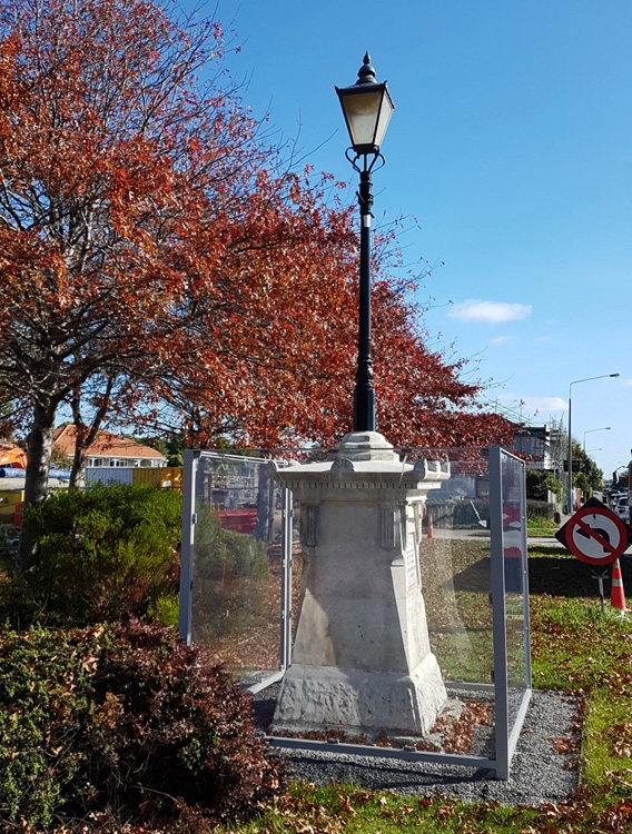
Woolston Borough Monument, Christchurch | Robyn Burgess | 02/05/2018 | Heritage New Zealand Pouhere Taonga
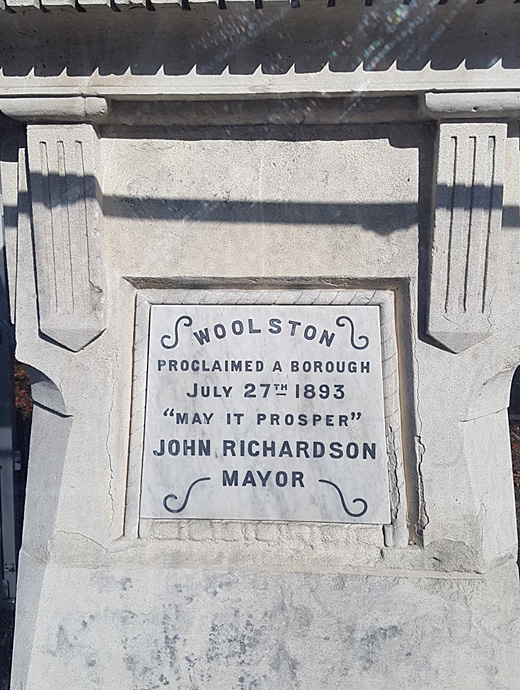
Woolston Borough Monument, Christchurch. North side marble plaque detail | Robyn Burgess | 02/05/2018 | Heritage New Zealand Pouhere Taonga
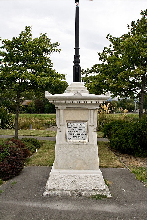
Woolston Borough Monument, Christchurch. CC Licence 2.0 Image courtesy of commons.wikimedia.org | Paul Willyams | 20/01/2010 | Paul Willyams - Wikimedia Commons
Woolston Borough Monument, Christchurch | Robyn Burgess | 02/05/2018 | Heritage New Zealand Pouhere Taonga
Woolston Borough Monument, Christchurch. North side marble plaque detail | Robyn Burgess | 02/05/2018 | Heritage New Zealand Pouhere Taonga
Woolston Borough Monument, Christchurch. CC Licence 2.0 Image courtesy of commons.wikimedia.org | Paul Willyams | 20/01/2010 | Paul Willyams - Wikimedia Commons
