

List Entry Information
Status
Listed
List Entry Status
Historic Place Category 2
Access
Private/No Public Access
List Number
2251
Date Entered
23rd September 2005
Date of Effect
23rd September 2005
City/District Council
Dunedin City
Region
Otago Region
Extent of List Entry
Registration includes the bridge over the Tairei River on the Hyde-Macraes Road, its wings walls and abutments, part legal road, part marginal strip (see plan in Appendix 3 of registration report)
Legal description
No Certificate of Title. Part legal road, part marginal strip. Approximate Grid References - 2295360E 5539697N. NZMS 260 I42 Ed 1984, Ltd Rev. 1996.
Location Description
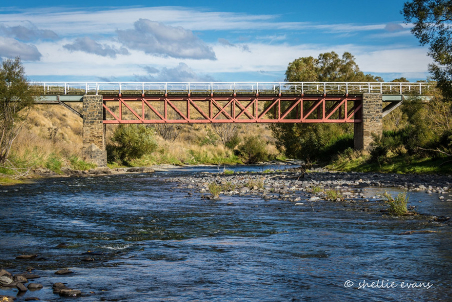
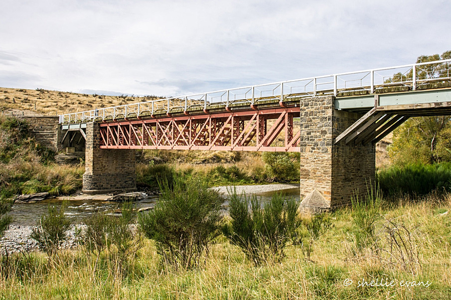
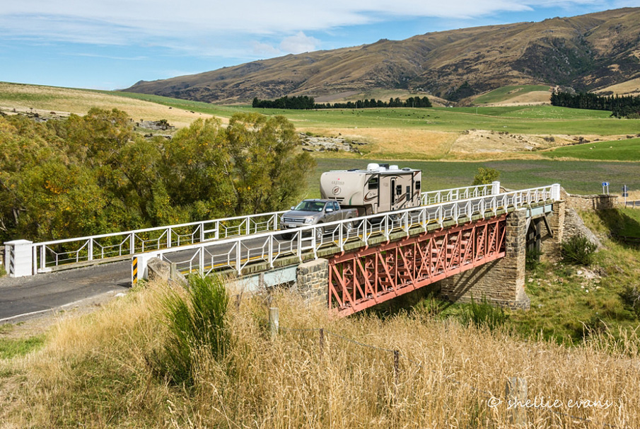
Spans the Taieri River on the Hyde-Macraes Road, close to the junction of that road and Mareburn Road.
Status
Listed
List Entry Status
Historic Place Category 2
Access
Private/No Public Access
List Number
2251
Date Entered
23rd September 2005
Date of Effect
23rd September 2005
City/District Council
Dunedin City
Region
Otago Region
Extent of List Entry
Registration includes the bridge over the Tairei River on the Hyde-Macraes Road, its wings walls and abutments, part legal road, part marginal strip (see plan in Appendix 3 of registration report)
Legal description
No Certificate of Title. Part legal road, part marginal strip. Approximate Grid References - 2295360E 5539697N. NZMS 260 I42 Ed 1984, Ltd Rev. 1996.
Location Description
Spans the Taieri River on the Hyde-Macraes Road, close to the junction of that road and Mareburn Road.
Why is this place significant?
Historic Significance
Historical Significance or Value The Bridge has historical significance. It is one of the earliest road bridges over the Taieri River in the Strath Taieri, is the result of community agitation and effort. The isolation of the area, and in particular the barrier that the Taieri River posed to both settlement and communication, forms a significant part of the history of the area, and is well illustrated by the stories associated with the agitation for, and the construction of the bridge.
Physical Significance
The Bridge has technological significance. As noted by Geoffrey Thornton it is a significant monument to engineering heritage, and in particular the work of the county engineer in managing the construction in what was then a remote and isolated site. Thornton considers this both an early and an unusual bridge design.
Why is this place Category 1 / Category 2?
Detail Of Assessed Criteria
The building of the bridge reflects the establishment of basic infrastructure of the Strath Taieri. The history of the development of roads, the bridging of rivers, and the connecting of communities in such isolated areas is a representative aspect of New Zealand history. This is one of the important early bridges in the Strath Taieri region. River crossing was a hazardous undertaking in colonial New Zealand, and the agitation for the bridge was an important expression of community concerns in the region in the 1870s. Geoffrey Thornton considers it a monument to the local community's determination to have the river bridged. The bridge has an association with a significant early engineer in Otago - Robert Henry Browne (1843-1907). Browne was District Engineer for the Provincial Government before transferring to the Maniototo County Council. He remained County Engineer until his death in August 1907, and was a significant figure in the region. The bridge has the potential to provide knowledge of New Zealand history. The bridge itself is illustrates the construction and engineering methods of the period. Through the story of its commissioning, backed up with the histories of drownings in the area which prompted public outcry, it reveals aspects of New Zealand's past which are largely overlooked today - such as the hazardous nature of travel in this isolated place. The design of the bridge is significant. As already mentioned it shows the work of Robert Browne. Geoffrey Thornton considers it a monument to the skill of this early engineer. He notes that the construction was a considerable feat given the isolation of the area.
Construction Professional
Name
Browne, Richard Herbert
Type
Engineer
Biography
Richard Herbert Browne (1843-1907) Browne was born in 1843 in Norwich. He left England age twenty, and after a few months in Melbourne came to New Zealand and spent all his professional life in Otago. For a few years prior to the abolition of the Provincial Government in 1876, he was District Engineer for Otago. Browne remained the County engineer until his death on 27 August 1907.
Construction Details
Start Year
1879
Type
Original Construction
Hyde (originally called Eight Mile), but renamed in honour of Provincial Superintendent John Hyde Harris, is an isolated community in the Strath Taieri district of Central Otago. Communications were difficult, the Taieri River could be dangerous in flood, and the Taieri Gorge was steep and in places impassable. Inland routes to the goldfields either took the Dunstan Road well to the south of Hyde, or the Pig Root to the north. This part of Maniototo was settled late due to its relative inaccessibility. Prospect of gold in the district was noted by official prospector Mr Macrae in November 1861, and a small but payable field was discovered six miles east of Hyde in winter 1862, known as the Highlay Diggings, midway between Hyde and Macraes. In August 1863 what was to become known as the Hyde district was included in the proclamation of the Mount Ida Goldfield. In 1864 there was a rush at the field at Hyde. Roads were constructed during the 1870s. The main connecting route for Hyde was with the isolated Macraes Flat gold field. Bullocky Denny Daley was the pioneer carrier in the mid-1860s who blazed the trail between Macraes and Hyde, which forms the basis of the modern road. A track ran between the Pig Root and Hyde, via Macraes Flat, and it was this route that saw the first bridge construction in the vicinity. In the early days of settlement travellers in the district had to use dangerous fords for some years: Hyde had two fords (one where Kokonga is today, the site of Taieri Lake Station, the other at Mardlings Flat, a mile below Hyde) , one on either side of the township. During the flood season, settlers would have to wait three or four weeks for supplies. In December 1873 a deputation waited on James Macandrew, Superintendent of the Province of Otago, to press for a bridge. The Taieri River was first bridged at Hogburn Junction in 1874. By 1874 the Hyde Progress Committee was becoming increasingly impatient. At Mardlings Crossing three lives were lost in the three years prior to November 1876. Public meetings were called to agitate for a bridge. County engineer Robert Herbert Browne, previously District Engineer for Otago Province, pushed for the bridge. He was apparently trained as an engineer and surveyor, and was a savvy operator, knowing who to approach for advice and equipment, which government departments to apply to for finance, and how to assess costings. Historian Janet Angus notes that his resourcefulness was demonstrated over the construction of the Hyde Bridge, writing to the Waikouaiti Council to see if they would share in securing the iron bridge "now in the hands of the Government and lying in Dunedin." Browne knew the bridge had been intended for the railway line, but it had fallen overboard in Sydney Harbour and had been abandoned for that purpose. Browne thought the bridge could be repaired and brought to Hyde for £275. The bridge was built for £2,560 by Mr Stephens of Naseby, with James Archibald as inspector. The bridge was under construction by 1878, with historian Janet Cowan noting a substantial bridge built over the Taieri during that year. She states that Patrick Kinney carted the stones for the piers, and some of the wood and iron work. Transport to the site was a considerable feat. It was taken to Palmerston by rail and then carted by bullock wagon over narrow upland tracks - a distance of 115 kilometres. Richard Kinsman, Jimmy Biggans, John Budge, W. Coatsworth, A. McKay and W. Mathews were noted as the builders and stone masons at that time. Contemporary accounts describe the bridge as having "a sturdy iron half-lattice type girder with handsome stone piers so typical of both road and rail bridges in Central Otago. The wooden arches at each end are purely ornamental." The bridge at Hyde survived the severe 1892 flood, the highest since 1868. The water was within three feet of the lower girder. Bridges over the Kyeburn were swept away as was the new horse traffic bridge at Capburn. Angus writing in 1977 found the earlier descriptions still apt, except that the stone cappings to the piers had been removed and the approaches strengthened and lengthened. In 1977 it was painted blue above the wooden arches and iron work, and was considered one of the finest sights on the county roads. Today the bridge is still in use on the road between Hyde and Macraes Flat.
Hyde (originally called Eight Mile), but renamed in honour of Provincial Superintendent John Hyde Harris, is an isolated community in the Strath Taieri district of Central Otago. Communications were difficult, the Taieri River could be dangerous in flood, and the Taieri Gorge was steep and in places impassable. Inland routes to the goldfields either took the Dunstan Road well to the south of Hyde, or the Pig Root to the north. This part of Maniototo was settled late due to its relative inaccessibility. Prospect of gold in the district was noted by official prospector Mr Macrae in November 1861, and a small but payable field was discovered six miles east of Hyde in winter 1862, known as the Highlay Diggings, midway between Hyde and Macraes. In August 1863 what was to become known as the Hyde district was included in the proclamation of the Mount Ida Goldfield. In 1864 there was a rush at the field at Hyde. Roads were constructed during the 1870s. The main connecting route for Hyde was with the isolated Macraes Flat gold field. Bullocky Denny Daley was the pioneer carrier in the mid-1860s who blazed the trail between Macraes and Hyde, which forms the basis of the modern road. A track ran between the Pig Root and Hyde, via Macraes Flat, and it was this route that saw the first bridge construction in the vicinity. In the early days of settlement travellers in the district had to use dangerous fords for some years: Hyde had two fords (one where Kokonga is today, the site of Taieri Lake Station, the other at Mardlings Flat, a mile below Hyde) , one on either side of the township. During the flood season, settlers would have to wait three or four weeks for supplies. In December 1873 a deputation waited on James Macandrew, Superintendent of the Province of Otago, to press for a bridge. The Taieri River was first bridged at Hogburn Junction in 1874. By 1874 the Hyde Progress Committee was becoming increasingly impatient. At Mardlings Crossing three lives were lost in the three years prior to November 1876. Public meetings were called to agitate for a bridge. County engineer Robert Herbert Browne, previously District Engineer for Otago Province, pushed for the bridge. He was apparently trained as an engineer and surveyor, and was a savvy operator, knowing who to approach for advice and equipment, which government departments to apply to for finance, and how to assess costings. Historian Janet Angus notes that his resourcefulness was demonstrated over the construction of the Hyde Bridge, writing to the Waikouaiti Council to see if they would share in securing the iron bridge "now in the hands of the Government and lying in Dunedin." Browne knew the bridge had been intended for the railway line, but it had fallen overboard in Sydney Harbour and had been abandoned for that purpose. Browne thought the bridge could be repaired and brought to Hyde for £275. The bridge was built for £2,560 by Mr Stephens of Naseby, with James Archibald as inspector. The bridge was under construction by 1878, with historian Janet Cowan noting a substantial bridge built over the Taieri during that year. She states that Patrick Kinney carted the stones for the piers, and some of the wood and iron work. Transport to the site was a considerable feat. It was taken to Palmerston by rail and then carted by bullock wagon over narrow upland tracks - a distance of 115 kilometres. Richard Kinsman, Jimmy Biggans, John Budge, W. Coatsworth, A. McKay and W. Mathews were noted as the builders and stone masons at that time. Contemporary accounts describe the bridge as having "a sturdy iron half-lattice type girder with handsome stone piers so typical of both road and rail bridges in Central Otago. The wooden arches at each end are purely ornamental." The bridge at Hyde survived the severe 1892 flood, the highest since 1868. The water was within three feet of the lower girder. Bridges over the Kyeburn were swept away as was the new horse traffic bridge at Capburn. Angus writing in 1977 found the earlier descriptions still apt, except that the stone cappings to the piers had been removed and the approaches strengthened and lengthened. In 1977 it was painted blue above the wooden arches and iron work, and was considered one of the finest sights on the county roads. Today the bridge is still in use on the road between Hyde and Macraes Flat.
This bridge crosses the Taieri River on the Hyde-Macraes Road. The bridge has an iron lattice truss for the main span and short timber arch trusses at either end. The piers and abutments are stone. It was adapted to the site by the addition of a 30 ft (9.1m) span at each end, to give a total length of 160ft (48.7m). The deck is 30 ft (9.1m) above water level, and it has a load limit of 609 tonnes. According to historian Janet Cowan, the iron truss was fabricated in Dunedin. The bridge has been strengthened and some of the decking replaced since its construction.
This bridge crosses the Taieri River on the Hyde-Macraes Road. The bridge has an iron lattice truss for the main span and short timber arch trusses at either end. The piers and abutments are stone. It was adapted to the site by the addition of a 30 ft (9.1m) span at each end, to give a total length of 160ft (48.7m). The deck is 30 ft (9.1m) above water level, and it has a load limit of 609 tonnes. According to historian Janet Cowan, the iron truss was fabricated in Dunedin. The bridge has been strengthened and some of the decking replaced since its construction.
Historical and Associated Iwi / Hapū / Whānau
Completion Date
13th December 2005
Report Written By
Heather Bauchop
Information Sources
Angus, 1977 (2)
Janet C. Angus, Maniototo Milestone: A Centennial History of the Maniototo County Council, Maniototo Council, [Ranfurly], 1977
Cowan, 1948
Janet. C. Cowan, Down the Years in the Maniototo: A Survey of the Early History of Maniototo County and Naseby Borough, Otago Centennial Historical Publications, Whitcombe and Tombs, Dunedin, 1948
New Zealand Historic Places
New Zealand Historic Places
Thornton, 2001
Geoffrey Thornton, Bridging the Gap, Early Bridges in New Zealand 1830-1939, Auckland, 2001
Other Information
A fully referenced registration report is available from the NZHPT Otago/Southland Area office Please note that entry on the New Zealand Heritage List/Rarangi Korero identifies only the heritage values of the property concerned, and should not be construed as advice on the state of the property, or as a comment of its soundness or safety, including in regard to earthquake risk, safety in the event of fire, or insanitary conditions.
Current Usages
Uses: Transport
Specific Usage: Bridge/ Viaduct
Former Usages
General Usage: Transport
Specific Usage: Bridge/ Viaduct
Current Usages
Uses: Transport
Specific Usage: Bridge/ Viaduct
Former Usages
General Usage: Transport
Specific Usage: Bridge/ Viaduct
Location
Sign up to hear more
Get the latest heritage news, features and events delivered
straight to your inbox.
