

Thomson came to New Zealand in 1856 and almost immediately set to work forging his key role in the surveying of southern New Zealand. His first task as the Otago Province’s new Chief Surveyor was to go to Southland and establish which site would be best for its capital, Invercargill. In the years subsequent to this he surveyed inland Otago and in his role as Chief Engineer Thomson was also responsible for defining many important roads. After he retired in 1879 from his position as the first Surveyor-General of New Zealand, Thomson based himself at his a large home he designed for his family in Invercargill, and became a leading figure in that community. When Thomson died in 1884, his will set aside a sum to allow his family to build a mausoleum at St. John’s Cemetery in Waikiwi, on the outskirts of Invercargill. Subsequently his wife and eldest daughter were also interred in the family plot, as well as relatives such as important local community leader and historian, Frederick Hall-Jones (1891-1982).
John Turnbull Thomson Mausoleum and Family Plot consists of a semi-subterranean mausoleum building, adorned with a granite monument, as well as several marble memorial structures dating from the late nineteenth and early twentieth centuries, and two memorial plaques from the late twentieth century. In 2009 a restoration project replaced broken monument fixtures, as well as led to the sealing of the mausoleum in order to forestall the sequence of vandalism which had occurred in recent years. This project was led by the Historic Cemeteries Conservation Trust of New Zealand, with financial assistance from David Hall-Jones.
Thomson was not only Invercargill’s leading citizen at the time of his death in 1884, but his contribution to the history of settlement in Otago and Southland was nationally recognised. As such, John Turnbull Thomson Mausoleum and Family Plot has significance because it is directly associated with Thomson, and is a significant as his resting place. John Turnbull Thomson Mausoleum and Family Plot is picturesquely and prominently situated within St. John’s Cemetery and has further local historical importance because of the on-going significance that Thomson’s family and the extended Hall-Jones family had in the story of Invercargill and Southland.
List Entry Information
Status
Listed
List Entry Status
Historic Place Category 2
Access
Private/No Public Access
List Number
2497
Date Entered
23rd June 2011
Date of Effect
23rd June 2011
City/District Council
Invercargill City
Region
Southland Region
Extent of List Entry
Extent includes part of the land described as Sec 181 Blk XV Invercargill Hundred (RT SLA4/133), Southland Land District and the structures known as John Turnbull Thomson Mausoleum and Family Plot thereon, and its fittings and fixtures. The extent also includes curtilage of two metres from the concrete boundary around the plot. (Refer to map in Appendix 1 of the registration report for further information).
Legal description
Sec 181 Blk XV Invercargill Hundred (RT SLA4/133), Southland Land District
Location Description
The Thomson family plot is located in St. John’s Cemetery, at Waikiwi in north Invercargill, which is accessed from North Road/State Highway Six. Durham Street runs west from the highway and is just north of an opposing intersection with Bainfield Road. The cemetery is located at the west end of Durham Street on the northern side. Within the cemetery the mausoleum is positioned towards the west boundary, immediately behind the rows of graves on the southwest corner of the cemetery.
Why is this place significant?
Historic Significance
Historical Significance or Value The John Turnbull Thomson Mausoleum and Family Plot has historical importance as the resting place of John Turnbull Thomson, who in his role as an important surveyor and engineer in the mid nineteenth century put a European stamp on Southland and Otago, which opened up the area for further settlement. As such, Thomson has many geographical but few built legacies. Therefore, John Turnbull Thomson Mausoleum and Family Plot has value as an important physical tribute to this key figure in New Zealand history and one who was described at the time of his death as Invercargill’s leading citizen. Indeed, because he investigated the site for, and planned Invercargill, Thomson can be seen as the founding father of the city, which makes it a particularly pertinent place for his final resting. His descendents and later relatives continued to be significant contributors to that community and as such John Turnbull Thomson Mausoleum and Family Plot has considerable local historical importance. The marriage links to another prominent family, the Hall-Jones’, are evident at the site which includes a memorial to Frederick Hall-Jones who became influential in Invercargill in the post World War One period, a contribution recognised in 1958 with the honour of an OBE.
Physical Significance
Aesthetic Significance or Value: While the John Turnbull Thomson Mausoleum is a comparatively modest monument to this prominent figure in New Zealand’s history, the respect for Thomson and his family is demonstrated by the reverend distance between it and other burials, as well as the landscaping. Because of this the mausoleum has aesthetic value as the focal point within this picturesquely solemn and contemplative environment.
Why is this place Category 1 / Category 2?
Detail Of Assessed Criteria
(a) The extent to which the place reflects important or representative aspects of New Zealand history Although not an ostentatious monument, John Turnbull Thomson Mausoleum still reflects the high social status that was achieved by Thomson as a result of his being part of an influential profession in the European settlement of New Zealand - surveyors. It was through surveying that a European stamp was imposed on the land, but on a personal level John Turnbull Thomson Mausoleum and Family Plot speaks to an inherent desire by people from all strata of society to leave a physical reminder of their life after they have passed on. (b) The association of the place with events, persons, or ideas of importance in New Zealand history John Turnbull Thomson Mausoleum and Family Plot is directly associated with Thomson who was one of the seminal figures in the history of Otago and Southland. Thomson had many talents, but it was his work as a surveyor which had the greatest and lasting effect. Many of the places Thomson named, such as Lindis Pass, had autobiographical flavour, and his surveying work clearly demonstrates the desire of the early government to fully annex their new territory of New Zealand and imprint European ideas and understandings of land onto it. Thomson’s survey and engineering work in the lower South Island has been attributed as a key means by which European settlement was advanced. Thomson was nationally renowned during his life, being the first Surveyor-General of New Zealand, in which capacity he regulated and standardised the profession. Summary of Significance or Values This place was assessed against, and found it to qualify under the following criteria: a and b. Conclusion It is considered that this place qualifies as a Category II historic place.
Construction Details
Start Year
1885
startYearCirca
Type
Original Construction
Description
Mausoleum constructed
Start Year
1908
startYearCirca
Type
Addition
Description
Northeast monument and grave boundary constructed
Start Year
1912
startYearCirca
Type
Addition
Description
Southern side, west monument constructed
Start Year
1932
startYearCirca
Type
Addition
Description
Southern side, central monument constructed
Start Year
1982
startYearCirca
Type
Other
Description
Southeast corner memorial plaque installed
Start Year
1995
startYearCirca
Type
Other
Description
Memorial plaque south of mausoleum gate installed
Start Year
2009
Type
Other
Description
Mausoleum sealed, marble monument crosses replaced
Construction Materials
Concrete, granite, marble, Oamaru stone, steel
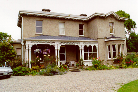
Maori History Ancient stories tell the origins of southern Maori, with the waka of Aoraki becoming Te Wai Pounamu (the South Island), and its sternpost, Te Taurapa a Te Waka o Aoraki becoming Bluff Hill (also known as Motupohue). The Maui traditions are told in the south, with Maui arriving in his waka Maahunui, and pulling up the stone to be used as an anchor - Te Puka o Te Waka a Maui (Rakiura). Maui's achievements are recognised in place names in the south, including Omaui near Bluff, and Te Tapuwae o Maui and Te Rereka o Maui in Fiordland (Maui's footstep and Maui's leap). Stories of the original explorers of the south are also told. The explorer Rakaihautu journeyed through the south with place names recalling his journey. After Rakaihautu came the Takitimu waka with Tamatea Pokai Whenua. The waka was overcome by three waves O-te-wao, O-roko and O-kaka, coming to rest near the mouth of the Waiau (Waimeha). The three waves continued across the low lying lands and ended up as features of the landscape. The early generations learnt about the land and its resources: stone sources were found, and stone (especially pounamu) became an important trading item. Kaika were established close to resources. Rights and resources and places were established, and traditions established which protected the manawhenua. When traditions were written down Kati Mamoe and Kai Tahu dominate the history after Waitaha, with stories of war and peace, and intermarriage that spread through the south. In the early 1820s there was further fighting, with muskets first being used at this time, with major sieges in the more northern area of the South Island leading a retreat to the south. Ruapuke Island became the centre of leadership in the south, its isolation giving a measure of security. The final fight with the northern taua of Te Puoho and his followers at Tuturau in 1835-1836, where Te Puoho was defeated, saw the end of warfare in the region. According to the Ngai Tahu Statutory acknowledgments in the settlement important villages along the south coast included: Te Wae Wae (Waiau), Taunoa (Orepuki), Kawakaputaputa (Wakapatu), Oraka (Colac bay), Aparima, Turangiteuaru, Awarua (Bluff), Te Whera, Toe Toe (mouth of the Mataura River) and Waikawa. Mokamoka (also known as Mokemoke or Mokomoko) was a settlement at the Invercargill estuary sustained by the rich resources found there. Tauranga waka occur up and down the coast linking land and sea trails with mahinga kai resources. Whaling boats plied the waters from the 1820s leading to changes in settlement patterns and resource use. 1853 saw the Murihiku purchase which left Maori south of the Waitaki (excluding the Otakou Block) with only 4,630 acres, the start of a long quest by southern Maori for justice questioning the legality of the purchase as well as the inadequacy of the land reserved. It was soon after these land purchases that Invercargill township was laid out by chief surveyor John Turnbull Thomson (1821-1884) in 1856. John Turnbull Thomson and family Thomson was born in Northumberland in England and spent much of his youth in the north of England and in Scotland. His studies included mathematics at Aberdeen University and engineering at Newcastle upon Tyne. Thomson’s upbringing is reflected in many of the places that he named in the South Island, among which are Lindis Pass, named after Lindisfarne Island near his early home, Mount Earnslaw after his grandfather’s farm, as well as places such as Twizel River, Cardrona River, and Mount St. Bathans. Although chiefly celebrated in New Zealand as a surveyor, Thomson was not exclusively so, also being noted as an engineer, architect, explorer, artist, and writer. This full range of talents was perhaps first appreciated when he was appointed Governor Surveyor of Singapore in 1841, after having worked in Malaysia for three years prior. Aside from survey duties he was also responsible for engineering roads and bridges, and Thomson designed key buildings such as hospitals, but also the Dalhousie Obelisk and the Horsburgh Lighthouse. Watercolour paintings he created of general scenes around Singapore are recognised as an important record of this period of settlement, as are his writings, such as Glimpses into Life in Malayan Lands. Later, one Otago commentator disparagingly described Thomson’s paintings as having ‘very little merit in their execution to commend them to notice.’ However, Thomson clearly enjoyed painting and was able enough to have one hung in the Dunedin Town Hall, and several are now in the collection of Hocken Library in Dunedin. Thomson’s time in Singapore came to an end in 1853 when illness caused him to return to England to convalesce, after which he decided to immigrate to New Zealand. Upon arrival in Auckland in 1856, Thomson was quick to secure a prominent surveying position in his newly adopted country. It was in Auckland that William Cargill (1784-1860), Superintendent of Otago Province, approached him to become Chief Surveyor of the province. Soon after, Thomson made his way to Dunedin and launched into his new job. Thomson’s first task as Chief Surveyor was to find a suitable location for the town of Invercargill. Unlike earlier European surveys of Southland, Thomson’s approach seems to have been more in-depth. In clarifying why he believed Invercargill to be the best sited capital for the area Thomson stated that: ‘An acquaintance with the interior, its topographical features and communications, as well as the completion of a careful survey of the rivers from their embouchures to the heads of their navigation, all combined to point out the head of the Waihopai navigation to be the position for the capital (now called Invercargill). At Invercargill the interior traffic can centre - to here the seaborne traffic can be brought. It is consequently here that the interchange of merchandise can take place, and people congregate for that purpose.’ The strength of his conviction is perhaps reflected in the fact that Thomson bought a significant amount of land in Invercargill and when he retired in 1879 he returned there. After establishing the site, Thomson planned Invercargill in a manner which almost a century later was credited with Invercargill having ‘few town-planning problems, for it was laid out with wide streets and generous areas of parks and reserves...’ Upon completing his work in Invercargill, Thomson did not rest upon his laurels, and soon began what has been described as ‘his marathon reconnaissance survey of Otago’ in 1857 and 1858. It was then that he named many features in Otago, giving many places a particular character. The barren landscape of the Maniototo is a veritable barnyard with Eweburn, Oxburn, Hogburn, Pigburn, and Sowburn, reflecting Thomson’s reaction to not being allowed to use Maori names in the area. Following this, in his role as Otago Provincial Engineer, Thomson was reasonable for establishing main roads out of Dunedin and others, such as the Dunstan Road which led to the Otago gold fields. Later he also designed accompanying bridges like the Waianakarua River Road Bridge. Thomson’s work in Otago was a recognised achievement, and when the provincial system was abolished in favour of centralised government he was appointed the first Surveyor-General of New Zealand. The Thomson family benefitted from Thomson’s ‘life devoted to assiduous labor [sic], and the application of foresight and judgement when opportunity came,’ which led to his ‘accumulating a considerable and honourable fortune.’ Therefore, when he retired in 1879 he was able to build a commodious residence which he called Lennel (Category I, Record No. 389). Thomson’s busy retirement included him becoming a Borough Councillor, and also being elected Mayor of Gladstone. Thomson continued his interest in intellectual pursuits in his role as a founding member and President of the Southland Institute. He had earlier been among the founders of the Otago Institute. Thomson’s retirement was only to last five years because he died at his home in Invercargill on 16 October 1884 after a serious illness of six months. As would be expected for such a high profile personality, news of Thomson’s death was published in newspapers all around New Zealand, with the Southland Times stating: ‘Mr Thomson was our most prominent citizen and had long been a man of mark in New Zealand.’ Correspondingly, Thomson’s funeral was a large one, with a cortege that reportedly consisting of ‘31 carriages, gentlemen on horseback, and a number on foot.’ Thomson was interred at the family vault in St. John’s Cemetery, in Waikiwi, a northern suburb of Invercargill. Thomson’s will directed that £200 be used ‘for a vault and monument for himself and such of his family as may rest therein.’ The legacy of Thomson and his immediate family is highly visible in Invercargill, with landmarks such as Thomson Bush and Turnbull Thomson Park. This latter large tract of land was donated to the city in 1935 by two of Thomson’s daughters, Miss P. O. Thomson of London and her sister, Miss N. E. Thomson, who lived in Christchurch. In the wider South Island landscape his prominence is also recognised: two mountains in the Southern Alps, Mounts Turnbull and Thomson, are named in recognition of his work in that region, as are the Turnbull Thomson Falls at the base of Mount Aspiring. Thomson’s descendants have continued to honour their illustrious ancestor through such avenues as the establishment of a University of Otago history scholarship in 2005. As envisaged by Thomson, the mausoleum and family plot in St. John’s Cemetery has become the resting place for some of his immediate family and later relatives. These include his wife, Jane Williamson (1833-1908), who Thomson married in 1858, and was herself from a prominent Otago family who were among the pioneer settlers in the province. The couple’s eldest daughter, Janet Mackie Bush, is also interred in the plot. Among other relatives buried within the family plot is Frederick George Hall-Jones (1891-1982). Hall-Jones married Thomson’s granddaughter, Marjorie Carlo Bush Thomson (1896-1967), in 1919 after he moved to Invercargill to practice law. In 1925 he purchased Lennel, and began to assert himself in the community through his profession, but also as a Borough and City Councillor, and by writing many histories as well as biographies of both John Turnbull Thomson and his father, former Prime Minister William Hall-Jones (1851-1936). As well as this, Hall-Jones was involved at a governance level in many local organisations, such as the Rotary Club of Invercargill and Invercargill Returned Services’ Association. Hall-Jones’ contribution to Southland’s historical record, and as a community leader, were recognised in 1958 when he was made an Officer of the Order of the British Empire (OBE). The most recent family member buried at John Turnbull Thomson Mausoleum and Family Plot was Patricia Hazel Hall-Jones (1923-2000) in 2000. By 2006 the vandalism and general deterioration of the mausoleum was cause for concern amongst the Hall-Jones family and also the Historic Cemeteries Conservation Trust of New Zealand. The original gates had even been removed for safe keeping by Invercargill City Council who administers St. John’s Cemetery. Eventually this led to a restoration project at the site in 2009, funded by the David Hall-Jones, which saw the monuments surrounding the mausoleum repaired, and the vault sealed in order to prevent further graffiti and vandalism inside. In 2011 the restored John Turnbull Thomson Mausoleum and the Family Plot sits in its prominent site in the corner of St. John’s Cemetery in Invercargill.
Maori History Ancient stories tell the origins of southern Maori, with the waka of Aoraki becoming Te Wai Pounamu (the South Island), and its sternpost, Te Taurapa a Te Waka o Aoraki becoming Bluff Hill (also known as Motupohue). The Maui traditions are told in the south, with Maui arriving in his waka Maahunui, and pulling up the stone to be used as an anchor - Te Puka o Te Waka a Maui (Rakiura). Maui's achievements are recognised in place names in the south, including Omaui near Bluff, and Te Tapuwae o Maui and Te Rereka o Maui in Fiordland (Maui's footstep and Maui's leap). Stories of the original explorers of the south are also told. The explorer Rakaihautu journeyed through the south with place names recalling his journey. After Rakaihautu came the Takitimu waka with Tamatea Pokai Whenua. The waka was overcome by three waves O-te-wao, O-roko and O-kaka, coming to rest near the mouth of the Waiau (Waimeha). The three waves continued across the low lying lands and ended up as features of the landscape. The early generations learnt about the land and its resources: stone sources were found, and stone (especially pounamu) became an important trading item. Kaika were established close to resources. Rights and resources and places were established, and traditions established which protected the manawhenua. When traditions were written down Kati Mamoe and Kai Tahu dominate the history after Waitaha, with stories of war and peace, and intermarriage that spread through the south. In the early 1820s there was further fighting, with muskets first being used at this time, with major sieges in the more northern area of the South Island leading a retreat to the south. Ruapuke Island became the centre of leadership in the south, its isolation giving a measure of security. The final fight with the northern taua of Te Puoho and his followers at Tuturau in 1835-1836, where Te Puoho was defeated, saw the end of warfare in the region. According to the Ngai Tahu Statutory acknowledgments in the settlement important villages along the south coast included: Te Wae Wae (Waiau), Taunoa (Orepuki), Kawakaputaputa (Wakapatu), Oraka (Colac bay), Aparima, Turangiteuaru, Awarua (Bluff), Te Whera, Toe Toe (mouth of the Mataura River) and Waikawa. Mokamoka (also known as Mokemoke or Mokomoko) was a settlement at the Invercargill estuary sustained by the rich resources found there. Tauranga waka occur up and down the coast linking land and sea trails with mahinga kai resources. Whaling boats plied the waters from the 1820s leading to changes in settlement patterns and resource use. 1853 saw the Murihiku purchase which left Maori south of the Waitaki (excluding the Otakou Block) with only 4,630 acres, the start of a long quest by southern Maori for justice questioning the legality of the purchase as well as the inadequacy of the land reserved. It was soon after these land purchases that Invercargill township was laid out by chief surveyor John Turnbull Thomson (1821-1884) in 1856. John Turnbull Thomson and family Thomson was born in Northumberland in England and spent much of his youth in the north of England and in Scotland. His studies included mathematics at Aberdeen University and engineering at Newcastle upon Tyne. Thomson’s upbringing is reflected in many of the places that he named in the South Island, among which are Lindis Pass, named after Lindisfarne Island near his early home, Mount Earnslaw after his grandfather’s farm, as well as places such as Twizel River, Cardrona River, and Mount St. Bathans. Although chiefly celebrated in New Zealand as a surveyor, Thomson was not exclusively so, also being noted as an engineer, architect, explorer, artist, and writer. This full range of talents was perhaps first appreciated when he was appointed Governor Surveyor of Singapore in 1841, after having worked in Malaysia for three years prior. Aside from survey duties he was also responsible for engineering roads and bridges, and Thomson designed key buildings such as hospitals, but also the Dalhousie Obelisk and the Horsburgh Lighthouse. Watercolour paintings he created of general scenes around Singapore are recognised as an important record of this period of settlement, as are his writings, such as Glimpses into Life in Malayan Lands. Later, one Otago commentator disparagingly described Thomson’s paintings as having ‘very little merit in their execution to commend them to notice.’ However, Thomson clearly enjoyed painting and was able enough to have one hung in the Dunedin Town Hall, and several are now in the collection of Hocken Library in Dunedin. Thomson’s time in Singapore came to an end in 1853 when illness caused him to return to England to convalesce, after which he decided to immigrate to New Zealand. Upon arrival in Auckland in 1856, Thomson was quick to secure a prominent surveying position in his newly adopted country. It was in Auckland that William Cargill (1784-1860), Superintendent of Otago Province, approached him to become Chief Surveyor of the province. Soon after, Thomson made his way to Dunedin and launched into his new job. Thomson’s first task as Chief Surveyor was to find a suitable location for the town of Invercargill. Unlike earlier European surveys of Southland, Thomson’s approach seems to have been more in-depth. In clarifying why he believed Invercargill to be the best sited capital for the area Thomson stated that: ‘An acquaintance with the interior, its topographical features and communications, as well as the completion of a careful survey of the rivers from their embouchures to the heads of their navigation, all combined to point out the head of the Waihopai navigation to be the position for the capital (now called Invercargill). At Invercargill the interior traffic can centre - to here the seaborne traffic can be brought. It is consequently here that the interchange of merchandise can take place, and people congregate for that purpose.’ The strength of his conviction is perhaps reflected in the fact that Thomson bought a significant amount of land in Invercargill and when he retired in 1879 he returned there. After establishing the site, Thomson planned Invercargill in a manner which almost a century later was credited with Invercargill having ‘few town-planning problems, for it was laid out with wide streets and generous areas of parks and reserves...’ Upon completing his work in Invercargill, Thomson did not rest upon his laurels, and soon began what has been described as ‘his marathon reconnaissance survey of Otago’ in 1857 and 1858. It was then that he named many features in Otago, giving many places a particular character. The barren landscape of the Maniototo is a veritable barnyard with Eweburn, Oxburn, Hogburn, Pigburn, and Sowburn, reflecting Thomson’s reaction to not being allowed to use Maori names in the area. Following this, in his role as Otago Provincial Engineer, Thomson was reasonable for establishing main roads out of Dunedin and others, such as the Dunstan Road which led to the Otago gold fields. Later he also designed accompanying bridges like the Waianakarua River Road Bridge. Thomson’s work in Otago was a recognised achievement, and when the provincial system was abolished in favour of centralised government he was appointed the first Surveyor-General of New Zealand. The Thomson family benefitted from Thomson’s ‘life devoted to assiduous labor [sic], and the application of foresight and judgement when opportunity came,’ which led to his ‘accumulating a considerable and honourable fortune.’ Therefore, when he retired in 1879 he was able to build a commodious residence which he called Lennel (Category I, Record No. 389). Thomson’s busy retirement included him becoming a Borough Councillor, and also being elected Mayor of Gladstone. Thomson continued his interest in intellectual pursuits in his role as a founding member and President of the Southland Institute. He had earlier been among the founders of the Otago Institute. Thomson’s retirement was only to last five years because he died at his home in Invercargill on 16 October 1884 after a serious illness of six months. As would be expected for such a high profile personality, news of Thomson’s death was published in newspapers all around New Zealand, with the Southland Times stating: ‘Mr Thomson was our most prominent citizen and had long been a man of mark in New Zealand.’ Correspondingly, Thomson’s funeral was a large one, with a cortege that reportedly consisting of ‘31 carriages, gentlemen on horseback, and a number on foot.’ Thomson was interred at the family vault in St. John’s Cemetery, in Waikiwi, a northern suburb of Invercargill. Thomson’s will directed that £200 be used ‘for a vault and monument for himself and such of his family as may rest therein.’ The legacy of Thomson and his immediate family is highly visible in Invercargill, with landmarks such as Thomson Bush and Turnbull Thomson Park. This latter large tract of land was donated to the city in 1935 by two of Thomson’s daughters, Miss P. O. Thomson of London and her sister, Miss N. E. Thomson, who lived in Christchurch. In the wider South Island landscape his prominence is also recognised: two mountains in the Southern Alps, Mounts Turnbull and Thomson, are named in recognition of his work in that region, as are the Turnbull Thomson Falls at the base of Mount Aspiring. Thomson’s descendants have continued to honour their illustrious ancestor through such avenues as the establishment of a University of Otago history scholarship in 2005. As envisaged by Thomson, the mausoleum and family plot in St. John’s Cemetery has become the resting place for some of his immediate family and later relatives. These include his wife, Jane Williamson (1833-1908), who Thomson married in 1858, and was herself from a prominent Otago family who were among the pioneer settlers in the province. The couple’s eldest daughter, Janet Mackie Bush, is also interred in the plot. Among other relatives buried within the family plot is Frederick George Hall-Jones (1891-1982). Hall-Jones married Thomson’s granddaughter, Marjorie Carlo Bush Thomson (1896-1967), in 1919 after he moved to Invercargill to practice law. In 1925 he purchased Lennel, and began to assert himself in the community through his profession, but also as a Borough and City Councillor, and by writing many histories as well as biographies of both John Turnbull Thomson and his father, former Prime Minister William Hall-Jones (1851-1936). As well as this, Hall-Jones was involved at a governance level in many local organisations, such as the Rotary Club of Invercargill and Invercargill Returned Services’ Association. Hall-Jones’ contribution to Southland’s historical record, and as a community leader, were recognised in 1958 when he was made an Officer of the Order of the British Empire (OBE). The most recent family member buried at John Turnbull Thomson Mausoleum and Family Plot was Patricia Hazel Hall-Jones (1923-2000) in 2000. By 2006 the vandalism and general deterioration of the mausoleum was cause for concern amongst the Hall-Jones family and also the Historic Cemeteries Conservation Trust of New Zealand. The original gates had even been removed for safe keeping by Invercargill City Council who administers St. John’s Cemetery. Eventually this led to a restoration project at the site in 2009, funded by the David Hall-Jones, which saw the monuments surrounding the mausoleum repaired, and the vault sealed in order to prevent further graffiti and vandalism inside. In 2011 the restored John Turnbull Thomson Mausoleum and the Family Plot sits in its prominent site in the corner of St. John’s Cemetery in Invercargill.
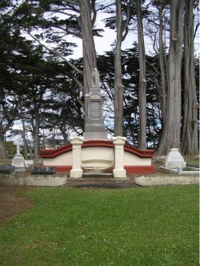
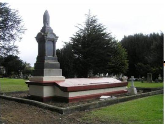
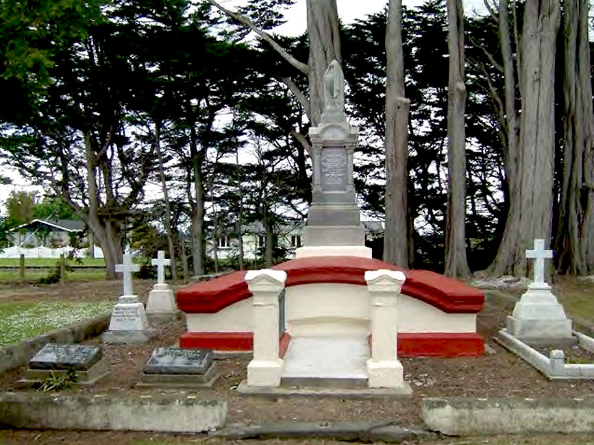
John Turnbull Thomson Mausoleum and Family Plot is located in St. John’s Cemetery in the northern Invercargill suburb of Waikiwi. The grassed and level cemetery has a roughly central axis defined by its main entrance and path. The eastern side of the site features condensed rows of burials, while the western side of the cemetery has several rows of graves towards its Durham Street frontage which are screened from the John Turnbull Thomson Mausoleum and Family Plot and subsequent longitudinal rows of burials, by mature plantings. Indeed, the John Turnbull Thomson Mausoleum and Family Plot is singled out from its counterparts by a sizeable curtilage, and plantings, including towering macrocarpa trees on the Gloucester Street boundary of the cemetery, reminiscent of William Sutton’s iconic painting, Nor’wester in the Cemetery (1950). John Turnbull Thomson Mausoleum and Family Plot consists of the mausoleum building, and several surrounding external monuments, contained within a concrete boundary which was previously the base for a metal rail fence. It is unclear when this fencing was removed. In itself, the John Turnbull Thomson Mausoleum is a comparatively modest monument. Other nineteenth century grave monuments are much more elaborate, for example, Larnach’s Tomb in Dunedin’s Northern Cemetery, which is a towering structure. However, the John Turnbull Thomson Mausoleum’s height, mass, and segregated location within the cemetery, make it a prominent point within the site. The circa 1885 mausoleum is mostly subterranean with its shallow vaulted concrete ceiling being approximately one metre above ground level at its apex. Prior to the 2009 restoration, the interior was accessible by way of the set of stairs on the east of the chamber, which is flanked by two painted Oamaru stone pillars and steel rail fencing. On the west end of the rectangular building is the mausoleum’s memorial monument. This granite structure, on a square concrete base, features a substantial inscription pedestal with a draped urn motif atop. Inscriptions to John Turnbull Thomson and Jane Williamson are on the east face, and the only other wording is present on the north side and is dedicated to Janet Mackie Bush. Each corner of the pedestal features decorative Corinthian columns that support an arch-top pediment. Engraved into the pediment are stylised floral embellishments either side of what appears to be a family crest. The large urn, traditionally symbolic of mourning, is sculpted with fabric adorning it, only exposing the urn on the southeast side. At the northeast corner of the mausoleum is the grave of Thomson’s wife Jane Williamson who died in 1908. This has a low marble surround with concrete base and a substantial monument at its west end. The memorial inscription spans the three tiers of the marble pedestal. The original cross shape which capped the monument was replaced in 2009. However, this has now also been dislodged and lies within the grave boundary. At the front of the plot south of the mausoleum are two low concrete plinths with black granite memorial plaques. The northern most plaque was installed circa 1995 upon the death of Geoffrey Hall-Jones and includes an inscription to Hazel Patricia Hall-Jones. Its companion is dedicated to Marjorie and Frederick Hall-Jones, and was most likely installed in 1982. Along the southern edge of the plot are two marble cross monuments and a disused small concrete base to the rear of the plot. Both monuments have small bases with inwards sloping sides which were designed with simple cross shapes attached on top. These crosses were also replaced in 2009. In the period subsequent to the restoration, the top of Noel Thomson’s monument, constructed circa 1912, has once again been dislodged. Its partner, dedicated to Janet Mackie Bush, is still complete.
John Turnbull Thomson Mausoleum and Family Plot is located in St. John’s Cemetery in the northern Invercargill suburb of Waikiwi. The grassed and level cemetery has a roughly central axis defined by its main entrance and path. The eastern side of the site features condensed rows of burials, while the western side of the cemetery has several rows of graves towards its Durham Street frontage which are screened from the John Turnbull Thomson Mausoleum and Family Plot and subsequent longitudinal rows of burials, by mature plantings. Indeed, the John Turnbull Thomson Mausoleum and Family Plot is singled out from its counterparts by a sizeable curtilage, and plantings, including towering macrocarpa trees on the Gloucester Street boundary of the cemetery, reminiscent of William Sutton’s iconic painting, Nor’wester in the Cemetery (1950). John Turnbull Thomson Mausoleum and Family Plot consists of the mausoleum building, and several surrounding external monuments, contained within a concrete boundary which was previously the base for a metal rail fence. It is unclear when this fencing was removed. In itself, the John Turnbull Thomson Mausoleum is a comparatively modest monument. Other nineteenth century grave monuments are much more elaborate, for example, Larnach’s Tomb in Dunedin’s Northern Cemetery, which is a towering structure. However, the John Turnbull Thomson Mausoleum’s height, mass, and segregated location within the cemetery, make it a prominent point within the site. The circa 1885 mausoleum is mostly subterranean with its shallow vaulted concrete ceiling being approximately one metre above ground level at its apex. Prior to the 2009 restoration, the interior was accessible by way of the set of stairs on the east of the chamber, which is flanked by two painted Oamaru stone pillars and steel rail fencing. On the west end of the rectangular building is the mausoleum’s memorial monument. This granite structure, on a square concrete base, features a substantial inscription pedestal with a draped urn motif atop. Inscriptions to John Turnbull Thomson and Jane Williamson are on the east face, and the only other wording is present on the north side and is dedicated to Janet Mackie Bush. Each corner of the pedestal features decorative Corinthian columns that support an arch-top pediment. Engraved into the pediment are stylised floral embellishments either side of what appears to be a family crest. The large urn, traditionally symbolic of mourning, is sculpted with fabric adorning it, only exposing the urn on the southeast side. At the northeast corner of the mausoleum is the grave of Thomson’s wife Jane Williamson who died in 1908. This has a low marble surround with concrete base and a substantial monument at its west end. The memorial inscription spans the three tiers of the marble pedestal. The original cross shape which capped the monument was replaced in 2009. However, this has now also been dislodged and lies within the grave boundary. At the front of the plot south of the mausoleum are two low concrete plinths with black granite memorial plaques. The northern most plaque was installed circa 1995 upon the death of Geoffrey Hall-Jones and includes an inscription to Hazel Patricia Hall-Jones. Its companion is dedicated to Marjorie and Frederick Hall-Jones, and was most likely installed in 1982. Along the southern edge of the plot are two marble cross monuments and a disused small concrete base to the rear of the plot. Both monuments have small bases with inwards sloping sides which were designed with simple cross shapes attached on top. These crosses were also replaced in 2009. In the period subsequent to the restoration, the top of Noel Thomson’s monument, constructed circa 1912, has once again been dislodged. Its partner, dedicated to Janet Mackie Bush, is still complete.
Historical and Associated Iwi / Hapū / Whānau
Completion Date
25th February 2011
Report Written By
Karen Astwood
Information Sources
McLintock, 1966
An Encyclopedia of New Zealand, Government Printer, Wellington, 1966
Watt, 1971
J O P Watt. Centenary Invercargill Municipality 1871 - 1971. Southland Times Printing Service, Invercargill, 1971.
Cunningham, 2005
G. Cunningham, Illustrated History of Central Otago and the Queenstown Lakes District, Auckland, 2005
Other Information
A fully referenced registration report is available from the NZHPT Otago/Southland Area Office Please note that entry on the New Zealand Heritage List/Rarangi Korero identifies only the heritage values of the property concerned, and should not be construed as advice on the state of the property, or as a comment of its soundness or safety, including in regard to earthquake risk, safety in the event of fire, or insanitary conditions.
Current Usages
Uses: Funerary Sites
Specific Usage: Headstone
Uses: Funerary Sites
Specific Usage: Mausoleum/Tomb/Vault/Ossario
Former Usages
General Usage: Funerary Sites
Specific Usage: Headstone
General Usage: Funerary Sites
Specific Usage: Mausoleum/Tomb/Vault/Ossario
Current Usages
Uses: Funerary Sites
Specific Usage: Headstone
Uses: Funerary Sites
Specific Usage: Mausoleum/Tomb/Vault/Ossario
Former Usages
General Usage: Funerary Sites
Specific Usage: Headstone
General Usage: Funerary Sites
Specific Usage: Mausoleum/Tomb/Vault/Ossario
Location
Sign up to hear more
Get the latest heritage news, features and events delivered
straight to your inbox.
