

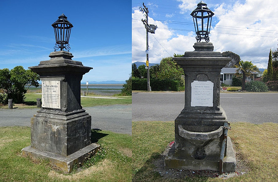
The settlement of the Nelson region by the New Zealand Company began in the early 1840s. However, the expansion into rural areas was difficult beyond the Waimea Plains because of the rudimentary nature of the land-based transport routes. As such, when relatively peripheral communities, like Motueka, began to coalesce during the 1850s, and looked to develop further, it was necessary to construct coastal shipping facilities. By the 1880s local people bemoaned the quality and capacity of the existing wharf at Motueka. Therefore, to enable the further growth of horticultural and other local industries, Motueka Wharf was constructed in 1887. The port was the main local portal for goods, communications, and passenger conveyance in the area, and because it was such a high profile site it was appropriate to erect the Trooper Tarrant Memorial there in 1903. The concrete memorial features a lamp and drinking fountain and honours the son of a prominent Nelson man Leonard M. Tarrant, who was killed in the South African (Boer) War.
The increased trade that Motueka Wharf enabled was eventually its downfall as industry developed to a point that the existing wharf facilities became insufficient. As such, the port was moved to a new location in 1916 and Motueka Wharf became redundant in terms of its original function. Subsequently, the Motueka Wharf and Memorial became a focal within the recreation area along the shoreline as the area gradually changed from an industrial to a residential area.
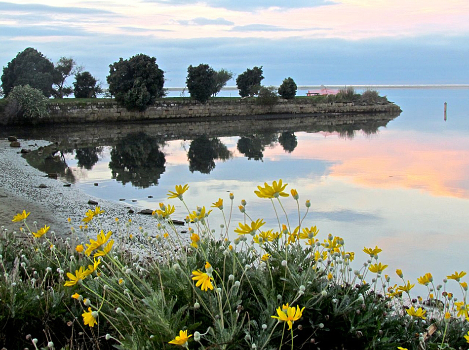
The Motueka Wharf and Memorial form a prominent landmark along the coastline at Motueka. The remains of the wharf include a causeway and seawalls constructed from locally sourced granite, the durability of which is demonstrated by contrast with the single timber pile which survives from the original timber section of the wharf. Despite this relative resilience several peripheral areas of the causeway and seawalls now show signs of age with the disintegration of some of the masonry. The wharf, and the area surrounding the square concrete column memorial, are grassed and form part of a leisure area along the coast which is connected by a walkway and lined with vegetation.
Because of its stone construction the surviving section of Motueka Wharf is nationally rare among other wharf structures. Within this group the use of granite for a causeway is unique. This means that Motueka Wharf is a nationally significant structure, but is also important because it is a remnant of coastal shipping, which was a representative feature of New Zealand's early transport and economic history. The wharf enabled efficient and essential conveyance of local goods and people, and as such was a key component in the development of Motueka district. The local social and historical importance of Motueka Wharf, as well as the community's loyalty to the British Empire, is physically demonstrated at the nearby memorial.
List Entry Information
Status
Listed
List Entry Status
Historic Place Category 2
Access
Able to Visit
List Number
2985
Date Entered
11th December 2009
Date of Effect
11th December 2009
City/District Council
Tasman District
Region
Tasman Region
Extent of List Entry
Extent includes parts of the lands described as Pt Sec 143MR Motueka District and Sec 100 Square 3, (NZ Gazette 1989, p.2377) Nelson Land District and the structures known as Motueka Wharf and Memorial thereon. This extent encompasses a reasonable curtilage which is the core area where archaeological material is likely to be deposited around the wharf, including the area that was the site of a timber section which formed a T-shaped adjunct on the east end of the granite wharf causeway. The extent excludes the current interpretation structure south of the memorial. (Refer to map in Appendix 1 of the registration report for further information).
Legal description
Pt Sec 143MR Motueka District and Sec 100 Square 3, (NZ Gazette 1989, p.2377) Nelson Land District
Location Description
When travelling north from Nelson and entering Motueka township via State Highway 60/Coastal Highway/High Street turn east into Old Wharf Road. Upon its termination this road leads into Motueka Quay. Motueka Wharf is situated towards the south end of Motueka Quay opposite house number 21 Motueka Quay. The reserve adjoining the wharf has a car park.
Why is this place significant?
Cultural Significance
Social Significance or Value Coastal shipping was an essential mode of transport and communication in the mid to late nineteenth century and was therefore of considerable local and national social importance. Motueka Wharf is representative of this and as the main local portal for the import and export of goods, as well as the conveyance of passengers, it is directly associated with the growth in the area's population. As the gateway to the district it also meant that the wharf was a busy and significant social gathering point for people working at the facilities or embarking and disembarking the vessels which moored at the wharf. The subsequent twentieth century use of Motueka Wharf and Memorial as a focal point of the recreational activities along the coastline means that these structures continue to have social value in connection with people's leisure activities.
Historic Significance
Historical Significance or Value From the mid 1850s the area in the immediate vicinity of Motueka Wharf was used as a wharf, becoming a vital asset for the district's development. The construction in 1887, and use of Motueka Wharf, is contemporary with the peak era of coastal shipping in New Zealand. As such, relatively small local wharves were of inestimable value to regional economies because shipping was the most efficient means of transporting goods and people in this period before road infrastructure was of a satisfactory standard. The replacement of the 1850s wharf with Motueka Wharf came at a crucial developmental time for the district's economy and is a lasting remnant of the period when Motueka transitioned from that of a frontier community to the commercial centre of a thriving local horticultural industry. Motueka Wharf facilitated this to such a degree that it brought about its own downfall, being abandoned as the port in 1916 in favour of a new wharf that was equal to increased local demand. Motueka Wharf is also of historical value because it stimulated the building of factories and service buildings nearby, and is now the only substantive remnant of this industrial area. The use of this site as the main port is documented on a memorial close to the wharf. This was constructed in 1903 to commemorate the sacrifice of Trooper Tarrant, peace in South Africa, and the accession of King Edward VII. The choice of location at Motueka Wharf is indicative of the high profile and visibility of this site as the main gateway to the outside world for the town, as well as the practical needs of those who frequented the wharf for drinking facilities and lighting.
Physical Significance
Aesthetic Significance or Value Motueka Wharf is a prominent local landmark on the gracefully curving coastline at Motueka, which forms an adjunct and creates a point of reference and interest. The shoreline features a walkway along which Motueka Wharf is a popular destination because it extends out into the estuary and is an excellent viewing platform by which to contemplate the beauty of the coastline. Therefore, Motueka Wharf is not only significant in itself for its local aesthetic and landmark value, but also because it facilitates the appreciation of the wider land and seascape. Technological Significance or Value Despite its relatively simple design, the remaining constituent part of Motueka Wharf, the granite causeway and seawalls, is of technical importance because it demonstrates the technical knowledge and accomplishment of the Akerstens who designed and constructed the structure. This skill is evidenced by the fact that both the materials and the causeway's original form have endured over a century of demanding conditions remarkably intact, albeit somewhat weathered.
Why is this place Category 1 / Category 2?
Detail Of Assessed Criteria
(a) The extent to which the place reflects important or representative aspects of New Zealand history Motueka Wharf is a remnant of the peak period of coastal shipping in New Zealand. This is an important feature of New Zealand history because it enabled the development of smaller provincial towns along the coastline, and their economies, in an age when land-based transport was rudimentary and inefficient in many areas, like the Motueka district. (c) The potential of the place to provide knowledge of New Zealand history Because Motueka Wharf is a pre-1900 structure it is protected under the archaeological provisions of the Historic Places Act. There is a high probability of debris and remnants, such as the timber piles, from the structure being present in the immediate area. This archaeological importance is enhanced by the previous port function of the structure, as accumulated deposits of waste and discarded material from the ships have the potential to provide information about the vessels that used the wharf, and more generally about the nature and extent of early coastal shipping in the region. The memorial not only details the importance of the wharf site in the development of Motueka, but provides other insights into its history and society by demonstrating the broader interests of Motueka's turn of the twentieth century community. For example it is indicative of the community's concern with events in the British Empire, such as the activities of the monarchy and the South African War. (e) The community association with, or public esteem for the place Motueka Wharf's function as an early port meant it was of seminal importance to the population growth of the area. The wharf's subsequent use and status as a landmark associated with leisure activities has ensured the continuance of the strong association with Motueka Wharf that the local community have had since it was built in the late nineteenth century. The community esteem for Motueka Wharf and Memorial has been the impetus behind the recent moves by its owners to restore the wharf structure and enhance the aesthetic appeal of the surrounding area. (j) The importance of identifying rare types of historic places Motueka Wharf is nationally unique because its long causeway is constructed from granite, one of several minerals found in the Nelson region that were recognised as being of high quality throughout New Zealand. Most early wharves in New Zealand were constructed from timber, and while Motueka Wharf had a timber component, the durability and suitability of the granite has been proven because it has endured while the mooring extension has not. (k) The extent to which the place forms part of a wider historical and cultural complex or historical and cultural landscape Coastal shipping is represented in the wider landscape of Nelson province with other structures and remnants of wharf structures and associated buildings dating from the mid nineteenth to early twentieth century, such as at Mapua and Nelson. As such, Motueka Wharf is part of a historical land and seascape which was integral to the development of settlement, trade, and the local economy in the Nelson region.
Construction Professional
Name
Akersten, William
Type
Engineer
Biography
William Akersten (1825-1905) William Akersten immigrated to Nelson when he was 21 and set about establishing a ships chandlery business and a reputation as a marine surveyor and engineer. He was a trained civil engineer and was responsible for designing and building the Albion and Provincial Government wharves at Nelson, as well as designing that in Motueka. It is said that it was also Akersten who suggested cutting an entrance to Nelson's harbour through the Boulder Bank to improve the shipping passage. He is commemorated in Nelson in the naming of Akersten Street and, before they were dismantled in 1991, a set of gates constructed at the entrance to the old port wharf in 1958 also bore his name, as does Akersten Bay in Abel Tasman National Park. (R.A. Venner, The Wakapuaka Cemetery: A place to walk and wonder, Nelson, 2002, n.p.)
Name
Akersten, Myles
Type
Builder
Biography
No biography is currently available for this construction professional
Name
Miller and Sons
Type
Builder
Biography
Miller and Sons This was a Nelson company that appears to have been active in the decades either side of the turn of the twentieth century. Originally their core business was monumental masonry, but this focus shifted in late 1903 with the firm becoming a construction company. Miller and Sons then went on to work on factories and other buildings, such as Nelson's hospital, as well as completing drainage and other contracts in the Nelson area. (Colonist, 22 October 1891, p. 3; Nelson Evening Mail, 1 December 1903, p.4; 'City Council,' Colonist, 12 October 1907, p.2; 'Nelson Freezing Company,' Wanganui Herald, 27 August 1908, p.5; ‘Hospital and Charitable Aid Board,' Nelson Evening Mail, 8 October 1908, p.1)
Construction Details
Start Year
1887
Type
Original Construction
Description
Motueka Wharf constructed
Start Year
1903
Type
Original Construction
Description
Trooper Tarrant Memorial completed
Start Year
1916
Type
Other
Description
Operations cease at Motueka Wharf and related structures are dismantled. Timber section left to degrade
Start Year
1920
startYearCirca
Type
Addition
Description
Addition to memorial of a plaque commemorating the area's use as the port of Motueka
Construction Materials
Concrete, earth fill, granite, mortar, steel, timber.
The settlement of the Nelson region is said to have begun with the landing of the prominent early iwi, Waitaha, in the waka Uruao. This travelled from Hawaiki and the voyagers made landfall on the Boulder Bank circa 850, near what would become Nelson city. From there scouting parties set out to explore the interior while others continued their sea journey down the east coast of the South Island. The settlement of the Nelson region then ensued and was driven by the fact that the area was found to be rich in resources, such as minerals for fashioning tradable items like adzes. Food, in the form of seal, moa and shellfish, was plentiful too and the district also had large tracts of land with fertile soil, or soil whose fertility could be manipulated, suitable for growing kumara and other garden produce. It was because of this abundance of resources that the district is said to have been 'one of the most fought over in New Zealand.' A European association with the Nelson area was first established in 1642 when Abel Tasman anchored in what was to be called Murderer's, then Massacre, and now Golden Bay. The result of this first visit was a lethal exchange between the Dutch sailors and Ngati Tumatakokiri. It was centuries after this initial encounter that European interest in the area began in earnest with explorative visits from Captain James Cook and Dumont D'Urville and a few others. Then in the late eighteenth to early nineteenth century flax traders and sealers began to frequent the coast around Nelson. However, because there were few whaling stations in the immediate area there was no substantive European settlement until the New Zealand Company's establishment and settlement of Nelson from 1841. The company explored the potential of several sites for its settlement but Nelson was chosen as the nucleus, despite the generally swampy nature of the low lying areas, because of its harbour and the plentiful supplies of game and fish. It was then a matter of Captain Arthur Wakefield meeting with the various iwi of the region to persuade them to agree to the proposed settlement. This was essentially a confirmation and extension of a land sale organised by the Tory expedition in 1839. The meeting took place at Kaiteriteri and Wakefield eventually negotiated a deal with those in attendance. However, subsequent events demonstrate that in regard to this and some later transactions there were discrepancies in what each party believed they had agreed to. This led to several instances of conflict in the Nelson region during the 1840s, in particular. Perhaps the most well-known occurrence was the 'Wairau Affray' in 1843. After the nucleus of the Nelson settlement was established settlers began to move into outlying areas and form rural communities. However, a significant hindrance to the initial expansion beyond the Waimea Plains was that transportation of people and goods was difficult because early road infrastructure was rudimentary and bridges were not common. This did not improve to a satisfactory level until the 1920s and therefore the economies of coastal settlements, like Motueka, relied heavily on coastal shipping, and it was not until the construction of the Nelson to Glenhope railway that the interior of the Tasman district began to be readily accessible. Motueka and coastal shipping Motueka was originally considered as one of the possible sites for the New Zealand Company settlement before Nelson was decided upon. However, because its distance from the company's eventual choice it meant that European incursion into the Motueka area was slow to take hold despite settlement beginning only a few years after Nelson was established. The first European settler in Motueka was Captain Frederick Moore who initiated the first scoping of the Nelson area for a possible New Zealand Company settlement. Moore had been to the Motueka region during this scouting exercise and came back to settle there in 1842 after creating a close association with it by marrying a local Te Ati Awa woman named Paru. It was because of Paru that Moore was granted land at Motueka. However, he soon ran foul of his in-laws by selling sections of that land which saw other settlers coming to Motueka in 1843. At that stage the available land around Motueka was found to be less fertile than other areas in the Nelson region and, after land issues had been resolved to the New Zealand Company and settler's satisfaction, it was therefore typically used for sheep farming from the mid 1840s. In the mid twentieth century the Nelson region bustled with shipping activity because of the early lack of satisfactory land-based transport infrastructure. This increased when Nelson became a key New Zealand coastal shipping port during the 1860s after the Provincial Government constructed a wharf there in 1860. This project was undertaken by William Akersten whose family arrived in Nelson in 1855. Akersten ran a marine surveying, supplies, and engineering business, and it was his experience at Nelson's port, and on other contracts, which led to his employment designing the Motueka Wharf several decades later. The port at Nelson received few ocean-going vessels, but its importance as a coastal shipping port meant that in the 1880s it was the 'busiest provincial port in New Zealand.' From Nelson goods from all over the district were exported to other big ports around the country. Like many of Nelson's satellite settlements, Motueka did not begin to coalesce into a town until the 1850s, and it was with this that adequate coastal shipping facilities became a growing local concern. From early in the settlement of Motueka the site of the Motueka Wharf was used for the purpose of landing coastal vessels. There were several sites used as boat landings prior to the mid nineteenth century but that at the entrance to Doctor's Creek, located at the end of the present Old Wharf Road, was reportedly the most popular one. There is evidence that local iwi had used this as a landing site and early European settlers recognised the astuteness of this choice by also using the site. The need of the emerging township of Motueka for better wharf facilities was sated in 1856 with the construction of a 2.4 metre wide timber t-shaped jetty close to the traditional landing site. An important event which was reported at length was the trial trip of the passenger and cargo paddle steamer the Tasmanian Maid, which then came into regular use, from Nelson to Motueka in June 1857. With the construction of the early wharf associated buildings and businesses sprang up close by, such as accommodation houses. One of these was the Retreat Inn which was constructed in 1858 and continued being used by the public who travelled along the immediate coastline, and also further afield to places such as Nelson and Wellington, until the late nineteenth century, and then was used as a boarding house. Other buildings were also constructed in the immediate area such as the harbour masters house, wharfingers houses, and small warehouses. However, despite consistent extension and additions to its facilities, by the early 1880s the 1850s wharf at Motueka was coming under increased criticism. The Nelson Weekly News was therefore pleased to announce in August 1886 that Motueka was to have new wharf, and not before time because the existing wharf was described as 'almost as dangerous as the Moslim's [sic] bridge to heaven.' Motueka Wharf The construction of the Motueka Wharf in 1887 was a family affair with William Akersten designing the structure and Myles Akersten contracted by the provincial government to build it. The cost of the structure was approximately £4,000, for which a substantial loan was taken out, and the design included a stone causeway to build up the land end of the wharf that then had a timber pile wharf extending further into the harbour. This part of the wharf featured the wharf offices and was where the coastal vessels moored. The granite causeway featured a tramway that led to the warehouses and factories surrounding the wharf area and also provided direct access to the ships for horse and cart traffic. It is perhaps not surprising that when designing the Motueka Wharf, a structure which would have to be robust and durable given its environment, Akersten chose to use local granite available at Astrolabe and Torrent Bays for the main causeway. The exploitation of the significant mineral resources of the area around the Tasman district has a long history. Maori established several argillite quarries around Motueka from the thirteenth century. This was a prized resource because it was perfect for the fashioning of hardy tools. Nelson province continued to be noted for its mineral resources after European settlement began and high profile buildings as Parliament House in Wellington are constructed from the region's stone. In particular, granite was sometimes used locally for building piles. Granite was also used for significant structures such as the Church Steps in Nelson and in the Public Trust Office Building, Wellington, and this stone, originating from Tonga Bay, has the distinction of being regarded as New Zealand's only true granite. Motueka Wharf enabled increased coastal shipping capacity. Because of the lack of other efficient modes of transport this facility was essential to the area's growth, and the wharf was a vital portal for cargo and passenger conveyance and other services such as mail circulation. Because of this latter role there was a post office and telephone exchange directly adjacent to the end of the causeway. Because of these factors the wharf was consistently busy and bustling with people, be they wharfingers, ships crew, delivery staff, embarking or disembarking passengers, and people gathered to meet or farewell the former. While an early focus of the local economy was agricultural, by the 1880s the fruit growing and processing industry in Motueka had been established on a small scale. An example of the extent of this is that one company produced approximately five tons of jam in 1881. But with the aid of the wharf by 1895 Motueka, along with Stoke, was considered a leading fruit growing and processing area in Nelson province, which in turn was recognised as the predominant berry-fruit growing region in New Zealand. Coastal shipping access was crucial for the agricultural industry in particular due to the perishable nature of much of the product and the associated need for efficient transportation. The importance and growth of this and other local industries during this period motivated the Motueka Wharf Board, who took ownership of the wharf in 1902, to immediately upgrade the facilities by extending of the timber section of Motueka Wharf. The period around 1902 was not only a time of change at the port, but also for the British Empire. This was represented at Motueka Wharf with the construction of a commemorative monument. Because Motueka Wharf was the major point of entry and exit to the town, and therefore a high profile spot, it was an appropriate location for a memorial. However, this choice of site was also tied in with the fact that residents had been petitioning the County Council to construct a drinking fountain and light at the wharf in 1900. It seems that the suggested addition of a plaque recognising the sacrifice of Trooper Tarrant, who died in the South African War and was the son of a prominent local man, to the already proposed structure was an astute manoeuvre to progress the project. From this time the focus of the project, which was initiated and promoted by wharfinger H.L. Moffat, became the construction of a memorial. By framing the project like this Trooper Tarrant could be genuinely honoured but, as a return for their generosity towards the memorial fund, the public could also expect to benefit through the addition of wharf utilities which the County Council was slow to grant. Originally, contributions towards the Trooper Tarrant memorial began to be collected in 1901, approximately a year before the South African War was finished. However, the process stalled until the next year with only half of the £37 cost collected. At this time the project was resurrected because it was felt that: The time is ripe for it just now, for with memories associated with a happy termination of the war, and the enthronement of King Edwards after a period of anxiety and suspense through illness, loyal subjects will all the more readily contribute. Therefore, in order to raise further the necessary funds the scope of the monument's dedication was expanded to include a celebration of both the end of the war and the accession of the new King. This appears to have been an accurate reading of the climate because almost all of the balance of the cost had been raised when the memorial was unveiled at a ceremony on 8 July 1903. A large gathering of local people and dignitaries, as well as mounted troops, were in attendance at the unveiling ceremony. The monument was described as 'an excellent piece of masonry, the work of Miller and Sons, Nelson.' The concrete structure was surmounted with a lamp, and on the wharf side it had a marble plaque dedicating the monument to the memory of Leonard M. Tarrant, the end of the South African War, and to the accession of King Edward VII. A water trough on the monument benefitted the numerous horses that were used to cart goods at the wharf. The human traffic at the wharf was not forgotten either as there was a fountain on the opposite side, which was greatly appreciated by those who worked at the wharf. These features fulfilled the functional purpose which had been the initial motivation for the memorial project. In 1905 the Motueka Wharf Board was incorporated and became known as the Motueka Harbour Board. Because Motueka was a shallow-draught port much of the income of the Motueka Harbour Board was derived from outward bound local fruit, timber and tobacco. In particular, fruit growing increased rapidly in the early years of the twentieth century with shipments from the wharf doubling between 1911 and 1915. This boom in the industry saw many companies build packing facilities and cool stores in close proximity to the wharf. A particular coup for Motueka was the presence of the Nelson District Fruitgrowers' Association's cider, vinegar, apple drying and preserving factory near Motueka Wharf. The company opted to base itself in Motueka and not Nelson when its proposal to build a private siding to the city's port was denied. Other company's such as St George Co. Ltd. also had a canning and jam making plant nearby, but like the Nelson District Fruitgrowers' Association's they were compelled to move their factory when a new wharf came into use in 1916. In the early years of the twentieth century the booming local horticultural industries, which the wharf had assisted in developing, were beginning to place a demand on the wharf facilities that could not continue to be met with the existing structure and, like the first wharf at Motueka, its shortcomings began to be highlighted and lamented publically. This resulted in the Motueka Harbour Board entreating the Marine Department to pay £13,000 to extend the wharf and dredge the harbour. This cost was dismissed by the government as untenable considering the size of the district. Therefore, the Harbour Board was forced to consider more cost effective solutions which could provide improved services to the local region, and within a decade they launched an extensive building programme that would see a new wharf built at a location in the Moutere Inlet. The new wharf was operative in 1916 and it then became the focus of the areas transport and industrial processing facilities, rendering Motueka Wharf, and the surrounding industrial area, largely redundant. However, later a plaque was attached to the memorial at Motueka Wharf to commemorate the use of the area as the early port of the town. Despite the creation of the new wharf, Motueka Wharf continued to be owned by the Motueka Harbour Board, but was not used as part of their operations and the buildings on the wharf were removed. Because of the new facilities Motueka Wharf was not maintained to the level it had been previously and between 1919 and 1925, the last time it appears as an asset of the Motueka Harbour Board, the value of the structure diminished from £700 to £225. It would appear that from this time onwards the timber sections of the wharf were left to degrade. The causeway fared better than the timber section of Motueka Wharf because of its construction materials and has subsequently been incorporated into a popular picnic and recreational area which evolved as the tenor of the area changed from industrial to residential. Aside from the wharf, other key features of this picturesque area include a beachside walkway and the wreck of the Janie Seddon. This ship was built in 1901 for the New Zealand Defence Department and later acquired by Talleys who converted it into a fishing vessel. In 1953 it was beached at its current location, close to Motueka Wharf, after it sunk while in its moorings. The heritage and social values of the wharf have long been recognised locally and in 2006 a project, led by Tasman District Council and supported by community groups such as Keep Motueka Beautiful, was launched to restore the structure starting with the commissioning of a conservation plan. As yet the recommendations in this report have not been implemented. However, the co-owners of the land and structure, Department of Conservation and the Council, are endeavouring to complete the project in the near future.
The settlement of the Nelson region is said to have begun with the landing of the prominent early iwi, Waitaha, in the waka Uruao. This travelled from Hawaiki and the voyagers made landfall on the Boulder Bank circa 850, near what would become Nelson city. From there scouting parties set out to explore the interior while others continued their sea journey down the east coast of the South Island. The settlement of the Nelson region then ensued and was driven by the fact that the area was found to be rich in resources, such as minerals for fashioning tradable items like adzes. Food, in the form of seal, moa and shellfish, was plentiful too and the district also had large tracts of land with fertile soil, or soil whose fertility could be manipulated, suitable for growing kumara and other garden produce. It was because of this abundance of resources that the district is said to have been 'one of the most fought over in New Zealand.' A European association with the Nelson area was first established in 1642 when Abel Tasman anchored in what was to be called Murderer's, then Massacre, and now Golden Bay. The result of this first visit was a lethal exchange between the Dutch sailors and Ngati Tumatakokiri. It was centuries after this initial encounter that European interest in the area began in earnest with explorative visits from Captain James Cook and Dumont D'Urville and a few others. Then in the late eighteenth to early nineteenth century flax traders and sealers began to frequent the coast around Nelson. However, because there were few whaling stations in the immediate area there was no substantive European settlement until the New Zealand Company's establishment and settlement of Nelson from 1841. The company explored the potential of several sites for its settlement but Nelson was chosen as the nucleus, despite the generally swampy nature of the low lying areas, because of its harbour and the plentiful supplies of game and fish. It was then a matter of Captain Arthur Wakefield meeting with the various iwi of the region to persuade them to agree to the proposed settlement. This was essentially a confirmation and extension of a land sale organised by the Tory expedition in 1839. The meeting took place at Kaiteriteri and Wakefield eventually negotiated a deal with those in attendance. However, subsequent events demonstrate that in regard to this and some later transactions there were discrepancies in what each party believed they had agreed to. This led to several instances of conflict in the Nelson region during the 1840s, in particular. Perhaps the most well-known occurrence was the 'Wairau Affray' in 1843. After the nucleus of the Nelson settlement was established settlers began to move into outlying areas and form rural communities. However, a significant hindrance to the initial expansion beyond the Waimea Plains was that transportation of people and goods was difficult because early road infrastructure was rudimentary and bridges were not common. This did not improve to a satisfactory level until the 1920s and therefore the economies of coastal settlements, like Motueka, relied heavily on coastal shipping, and it was not until the construction of the Nelson to Glenhope railway that the interior of the Tasman district began to be readily accessible. Motueka and coastal shipping Motueka was originally considered as one of the possible sites for the New Zealand Company settlement before Nelson was decided upon. However, because its distance from the company's eventual choice it meant that European incursion into the Motueka area was slow to take hold despite settlement beginning only a few years after Nelson was established. The first European settler in Motueka was Captain Frederick Moore who initiated the first scoping of the Nelson area for a possible New Zealand Company settlement. Moore had been to the Motueka region during this scouting exercise and came back to settle there in 1842 after creating a close association with it by marrying a local Te Ati Awa woman named Paru. It was because of Paru that Moore was granted land at Motueka. However, he soon ran foul of his in-laws by selling sections of that land which saw other settlers coming to Motueka in 1843. At that stage the available land around Motueka was found to be less fertile than other areas in the Nelson region and, after land issues had been resolved to the New Zealand Company and settler's satisfaction, it was therefore typically used for sheep farming from the mid 1840s. In the mid twentieth century the Nelson region bustled with shipping activity because of the early lack of satisfactory land-based transport infrastructure. This increased when Nelson became a key New Zealand coastal shipping port during the 1860s after the Provincial Government constructed a wharf there in 1860. This project was undertaken by William Akersten whose family arrived in Nelson in 1855. Akersten ran a marine surveying, supplies, and engineering business, and it was his experience at Nelson's port, and on other contracts, which led to his employment designing the Motueka Wharf several decades later. The port at Nelson received few ocean-going vessels, but its importance as a coastal shipping port meant that in the 1880s it was the 'busiest provincial port in New Zealand.' From Nelson goods from all over the district were exported to other big ports around the country. Like many of Nelson's satellite settlements, Motueka did not begin to coalesce into a town until the 1850s, and it was with this that adequate coastal shipping facilities became a growing local concern. From early in the settlement of Motueka the site of the Motueka Wharf was used for the purpose of landing coastal vessels. There were several sites used as boat landings prior to the mid nineteenth century but that at the entrance to Doctor's Creek, located at the end of the present Old Wharf Road, was reportedly the most popular one. There is evidence that local iwi had used this as a landing site and early European settlers recognised the astuteness of this choice by also using the site. The need of the emerging township of Motueka for better wharf facilities was sated in 1856 with the construction of a 2.4 metre wide timber t-shaped jetty close to the traditional landing site. An important event which was reported at length was the trial trip of the passenger and cargo paddle steamer the Tasmanian Maid, which then came into regular use, from Nelson to Motueka in June 1857. With the construction of the early wharf associated buildings and businesses sprang up close by, such as accommodation houses. One of these was the Retreat Inn which was constructed in 1858 and continued being used by the public who travelled along the immediate coastline, and also further afield to places such as Nelson and Wellington, until the late nineteenth century, and then was used as a boarding house. Other buildings were also constructed in the immediate area such as the harbour masters house, wharfingers houses, and small warehouses. However, despite consistent extension and additions to its facilities, by the early 1880s the 1850s wharf at Motueka was coming under increased criticism. The Nelson Weekly News was therefore pleased to announce in August 1886 that Motueka was to have new wharf, and not before time because the existing wharf was described as 'almost as dangerous as the Moslim's [sic] bridge to heaven.' Motueka Wharf The construction of the Motueka Wharf in 1887 was a family affair with William Akersten designing the structure and Myles Akersten contracted by the provincial government to build it. The cost of the structure was approximately £4,000, for which a substantial loan was taken out, and the design included a stone causeway to build up the land end of the wharf that then had a timber pile wharf extending further into the harbour. This part of the wharf featured the wharf offices and was where the coastal vessels moored. The granite causeway featured a tramway that led to the warehouses and factories surrounding the wharf area and also provided direct access to the ships for horse and cart traffic. It is perhaps not surprising that when designing the Motueka Wharf, a structure which would have to be robust and durable given its environment, Akersten chose to use local granite available at Astrolabe and Torrent Bays for the main causeway. The exploitation of the significant mineral resources of the area around the Tasman district has a long history. Maori established several argillite quarries around Motueka from the thirteenth century. This was a prized resource because it was perfect for the fashioning of hardy tools. Nelson province continued to be noted for its mineral resources after European settlement began and high profile buildings as Parliament House in Wellington are constructed from the region's stone. In particular, granite was sometimes used locally for building piles. Granite was also used for significant structures such as the Church Steps in Nelson and in the Public Trust Office Building, Wellington, and this stone, originating from Tonga Bay, has the distinction of being regarded as New Zealand's only true granite. Motueka Wharf enabled increased coastal shipping capacity. Because of the lack of other efficient modes of transport this facility was essential to the area's growth, and the wharf was a vital portal for cargo and passenger conveyance and other services such as mail circulation. Because of this latter role there was a post office and telephone exchange directly adjacent to the end of the causeway. Because of these factors the wharf was consistently busy and bustling with people, be they wharfingers, ships crew, delivery staff, embarking or disembarking passengers, and people gathered to meet or farewell the former. While an early focus of the local economy was agricultural, by the 1880s the fruit growing and processing industry in Motueka had been established on a small scale. An example of the extent of this is that one company produced approximately five tons of jam in 1881. But with the aid of the wharf by 1895 Motueka, along with Stoke, was considered a leading fruit growing and processing area in Nelson province, which in turn was recognised as the predominant berry-fruit growing region in New Zealand. Coastal shipping access was crucial for the agricultural industry in particular due to the perishable nature of much of the product and the associated need for efficient transportation. The importance and growth of this and other local industries during this period motivated the Motueka Wharf Board, who took ownership of the wharf in 1902, to immediately upgrade the facilities by extending of the timber section of Motueka Wharf. The period around 1902 was not only a time of change at the port, but also for the British Empire. This was represented at Motueka Wharf with the construction of a commemorative monument. Because Motueka Wharf was the major point of entry and exit to the town, and therefore a high profile spot, it was an appropriate location for a memorial. However, this choice of site was also tied in with the fact that residents had been petitioning the County Council to construct a drinking fountain and light at the wharf in 1900. It seems that the suggested addition of a plaque recognising the sacrifice of Trooper Tarrant, who died in the South African War and was the son of a prominent local man, to the already proposed structure was an astute manoeuvre to progress the project. From this time the focus of the project, which was initiated and promoted by wharfinger H.L. Moffat, became the construction of a memorial. By framing the project like this Trooper Tarrant could be genuinely honoured but, as a return for their generosity towards the memorial fund, the public could also expect to benefit through the addition of wharf utilities which the County Council was slow to grant. Originally, contributions towards the Trooper Tarrant memorial began to be collected in 1901, approximately a year before the South African War was finished. However, the process stalled until the next year with only half of the £37 cost collected. At this time the project was resurrected because it was felt that: The time is ripe for it just now, for with memories associated with a happy termination of the war, and the enthronement of King Edwards after a period of anxiety and suspense through illness, loyal subjects will all the more readily contribute. Therefore, in order to raise further the necessary funds the scope of the monument's dedication was expanded to include a celebration of both the end of the war and the accession of the new King. This appears to have been an accurate reading of the climate because almost all of the balance of the cost had been raised when the memorial was unveiled at a ceremony on 8 July 1903. A large gathering of local people and dignitaries, as well as mounted troops, were in attendance at the unveiling ceremony. The monument was described as 'an excellent piece of masonry, the work of Miller and Sons, Nelson.' The concrete structure was surmounted with a lamp, and on the wharf side it had a marble plaque dedicating the monument to the memory of Leonard M. Tarrant, the end of the South African War, and to the accession of King Edward VII. A water trough on the monument benefitted the numerous horses that were used to cart goods at the wharf. The human traffic at the wharf was not forgotten either as there was a fountain on the opposite side, which was greatly appreciated by those who worked at the wharf. These features fulfilled the functional purpose which had been the initial motivation for the memorial project. In 1905 the Motueka Wharf Board was incorporated and became known as the Motueka Harbour Board. Because Motueka was a shallow-draught port much of the income of the Motueka Harbour Board was derived from outward bound local fruit, timber and tobacco. In particular, fruit growing increased rapidly in the early years of the twentieth century with shipments from the wharf doubling between 1911 and 1915. This boom in the industry saw many companies build packing facilities and cool stores in close proximity to the wharf. A particular coup for Motueka was the presence of the Nelson District Fruitgrowers' Association's cider, vinegar, apple drying and preserving factory near Motueka Wharf. The company opted to base itself in Motueka and not Nelson when its proposal to build a private siding to the city's port was denied. Other company's such as St George Co. Ltd. also had a canning and jam making plant nearby, but like the Nelson District Fruitgrowers' Association's they were compelled to move their factory when a new wharf came into use in 1916. In the early years of the twentieth century the booming local horticultural industries, which the wharf had assisted in developing, were beginning to place a demand on the wharf facilities that could not continue to be met with the existing structure and, like the first wharf at Motueka, its shortcomings began to be highlighted and lamented publically. This resulted in the Motueka Harbour Board entreating the Marine Department to pay £13,000 to extend the wharf and dredge the harbour. This cost was dismissed by the government as untenable considering the size of the district. Therefore, the Harbour Board was forced to consider more cost effective solutions which could provide improved services to the local region, and within a decade they launched an extensive building programme that would see a new wharf built at a location in the Moutere Inlet. The new wharf was operative in 1916 and it then became the focus of the areas transport and industrial processing facilities, rendering Motueka Wharf, and the surrounding industrial area, largely redundant. However, later a plaque was attached to the memorial at Motueka Wharf to commemorate the use of the area as the early port of the town. Despite the creation of the new wharf, Motueka Wharf continued to be owned by the Motueka Harbour Board, but was not used as part of their operations and the buildings on the wharf were removed. Because of the new facilities Motueka Wharf was not maintained to the level it had been previously and between 1919 and 1925, the last time it appears as an asset of the Motueka Harbour Board, the value of the structure diminished from £700 to £225. It would appear that from this time onwards the timber sections of the wharf were left to degrade. The causeway fared better than the timber section of Motueka Wharf because of its construction materials and has subsequently been incorporated into a popular picnic and recreational area which evolved as the tenor of the area changed from industrial to residential. Aside from the wharf, other key features of this picturesque area include a beachside walkway and the wreck of the Janie Seddon. This ship was built in 1901 for the New Zealand Defence Department and later acquired by Talleys who converted it into a fishing vessel. In 1953 it was beached at its current location, close to Motueka Wharf, after it sunk while in its moorings. The heritage and social values of the wharf have long been recognised locally and in 2006 a project, led by Tasman District Council and supported by community groups such as Keep Motueka Beautiful, was launched to restore the structure starting with the commissioning of a conservation plan. As yet the recommendations in this report have not been implemented. However, the co-owners of the land and structure, Department of Conservation and the Council, are endeavouring to complete the project in the near future.
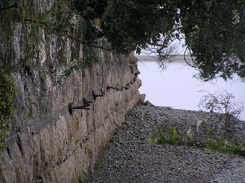
Motueka Wharf and Memorial are located on the slightly arching coast line at Motueka, approximate half way between the entrance to the Moutere Inlet (to the south) and the mouth of the Motueka River (to the north). During the time that the port was operative the west side of the Motueka Quay was an industrial area with factories, warehouses, and the like, but is now a residential area. The eastern side of Motueka Quay features a coastal walkway that has access points to the beach at various intervals between plantings of trees and shrubs. The form of the coastline is a relatively unimpeded and unbroken contour, and as such the interruption of this by the Motueka Wharf, which forms a peninsular, creates a focal point and prominent landmark along the shoreline. Wharf The perpendicular nature of the wharf appendage on the shore is clearly defined in the structure itself because the wharf's granite causeway has short seawalls flanking each side at 90 degree angles. These aspects of the structure all seem to be original features, the seawalls being included in the design in order to protect the land end of the causeway from erosion. These masonry wings are constructed from the same large, rectangular shaped, granite slabs of stone as the causeway. However, unlike the causeway masonry, the walls have not been repointed to the same extent, and where there is evidence of repointing it is of a rudimentary standard. The northern seawall was not able to be assessed as it is covered with vegetation. However, despite this it is apparent that the seawalls each side of the causeway have been undermined at their outer limits over the course of their life. The technically simple causeway design consists of an elongated rectangular granite masonry enclosure that is packed with earth and other fill. The interior material was levelled and a layer of asphalt applied to create a weather and water tight durable surface. Currently this is covered with grass and there are planting of trees and shubs spaced along the outer edges of the causeway, which are condensed at the land/west end of the structure. Like the seawalls, buffeting from the sea has meant that the causeway has disintegrated somewhat at its eastern end. At some stage in the late twentieth century irregular shaped slabs of concrete were placed around this outer edge to forestall further damage. This appears to have been an interim solution, but grass has now begun to grow over these. Other features of the causeway include rows of rusted steel bolts and brackets on each side which supported the timber handrail of the wharf. The eyelet steel stakes were most likely added after the original timber railing was removed. The recreational use of the wharf is apparent because of the inclusion of a simple timber picnic table towards the eastern end of the structure, as well as elsewhere in the reserve at the western end of the wharf. Because it dates from prior to 1900, the Motueka Wharf meets the legal definition of an archaeological site contained in the Historic Places Act. Remnants of the tramline are thought to be present underneath the mounded earth, and layer of grass on top of the asphalt. Although the timber section of the wharf has largely disintegrated, and the only portion visible above sea level is one timber pile a few metres southeast from the east end of the causeway, there is a strong probability that archaeological remains of the other piles are present. There are also likely to be other structural materials from the wharf such as dislodged stone, causeway fill, spikes, braces and other material. There is also a high possibility of other historical archaeological deposits being present, such as items that were lost or discarded which will have accumulated alongside the wharf. Typically this comprises glass and crockery and on-board domestic items, but also might include discarded ballast. These deposits are likely to be concentrated immediately adjacent to the wharf where vessels berthed, but might have accumulated on either side of the berthed vessel, so may be some distance away from what remains of the wharf. There were several small wharfs around the Nelson area which were essential for transport of people and product to the central port at Nelson. The closest of these to Motueka was at Mapua, and although there was a structure there contemporary with that at Motueka the current structure dates from 1921. This wharf at Mapua is a timber structure, as are the majority of wharves which the New Zealand Historic Places Trust has recognised as Category II registrations. There are two Category I wharfs on the Register of historic places; one is Old Stone Wharf, Whitianga (Record number 4675), the other is the reinforced concrete and timber wharf, Tolaga Bay Wharf (Record number 3516). Despite the fact that Motueka Wharf consists of the stone causeway and seawalls, and one of the piles of the original timber section, it is still a substantial structure, with the use of stone meaning it is a rare type of wharf structure. The use of granite in Motueka Wharf's construction appears to be nationally unique among remaining structures. Memorial The western end of the wharf is separated from the reserve carpark and grassed area by a low timber barrier spanning the causeway's width except for small access points at either end. In the grassed centre of a sealed turning circle at that end of the wharf, and situated along the centre line of Motueka Wharf, is the Memorial. This is an abbreviated concrete, square column, monument with a steel lamp surround at its pinnacle. The column sits upon a square concrete foundation before rising by way of a base, approximately one fourth of the height of the structure, which then steps in at its top. On the western side of the base is a half cone shaped feature which was a horse trough. The shaft of the memorial is above this and is of a similar height as the base. Two plaques are attached to this section and the one on the east side details its original function as a memorial to Trooper Tarrant, peace in South Africa, and King Edward VII's accession. However, the current plaque is not the original one, having been replaced at some point probably because of vandalism which was being reported as early as 1909. The other, early to mid twentieth century, plaque commemorates the use of the area as the Port of Motueka between 1857 and 1916 (west side of the structure). Each corner of each of the shaft's elevations has moulded leaf motifs, some of which have been damaged and chipped off. Above the shaft the concrete then splays outwards before stepping back towards the centre where the lamp is attached. Most of the war memorials around the Tasman region are dedicated to those who died in World Wars One and Two, with only a few South African War Memorials, one of which is in Collingwood. Like the Collingwood memorial most of the war memorials in the region are obelisks. Functional monuments like that at Motueka Wharf are in the minority, but predominantly take the form of public buildings or gates. The combining of the memorial with the drinking and lighting facilities in the Trooper Tarrant Memorial is unique within the region, but there are a few other examples of drinking fountains being included in South African War monuments, such as at the much grander Invercargill South African War Memorial. The majority of South African War memorials around New Zealand generally focused on celebrating the national contribution to the war. It is only at smaller places such as Shannon, Motueka, and Ross, that the tone of the memorial is mournful due to the specific dedication of the monument to an individual with the town who died during the war. However, with the Trooper Tarrant Memorial this is off-set by the dedications to peace and the accession.
Motueka Wharf and Memorial are located on the slightly arching coast line at Motueka, approximate half way between the entrance to the Moutere Inlet (to the south) and the mouth of the Motueka River (to the north). During the time that the port was operative the west side of the Motueka Quay was an industrial area with factories, warehouses, and the like, but is now a residential area. The eastern side of Motueka Quay features a coastal walkway that has access points to the beach at various intervals between plantings of trees and shrubs. The form of the coastline is a relatively unimpeded and unbroken contour, and as such the interruption of this by the Motueka Wharf, which forms a peninsular, creates a focal point and prominent landmark along the shoreline. Wharf The perpendicular nature of the wharf appendage on the shore is clearly defined in the structure itself because the wharf's granite causeway has short seawalls flanking each side at 90 degree angles. These aspects of the structure all seem to be original features, the seawalls being included in the design in order to protect the land end of the causeway from erosion. These masonry wings are constructed from the same large, rectangular shaped, granite slabs of stone as the causeway. However, unlike the causeway masonry, the walls have not been repointed to the same extent, and where there is evidence of repointing it is of a rudimentary standard. The northern seawall was not able to be assessed as it is covered with vegetation. However, despite this it is apparent that the seawalls each side of the causeway have been undermined at their outer limits over the course of their life. The technically simple causeway design consists of an elongated rectangular granite masonry enclosure that is packed with earth and other fill. The interior material was levelled and a layer of asphalt applied to create a weather and water tight durable surface. Currently this is covered with grass and there are planting of trees and shubs spaced along the outer edges of the causeway, which are condensed at the land/west end of the structure. Like the seawalls, buffeting from the sea has meant that the causeway has disintegrated somewhat at its eastern end. At some stage in the late twentieth century irregular shaped slabs of concrete were placed around this outer edge to forestall further damage. This appears to have been an interim solution, but grass has now begun to grow over these. Other features of the causeway include rows of rusted steel bolts and brackets on each side which supported the timber handrail of the wharf. The eyelet steel stakes were most likely added after the original timber railing was removed. The recreational use of the wharf is apparent because of the inclusion of a simple timber picnic table towards the eastern end of the structure, as well as elsewhere in the reserve at the western end of the wharf. Because it dates from prior to 1900, the Motueka Wharf meets the legal definition of an archaeological site contained in the Historic Places Act. Remnants of the tramline are thought to be present underneath the mounded earth, and layer of grass on top of the asphalt. Although the timber section of the wharf has largely disintegrated, and the only portion visible above sea level is one timber pile a few metres southeast from the east end of the causeway, there is a strong probability that archaeological remains of the other piles are present. There are also likely to be other structural materials from the wharf such as dislodged stone, causeway fill, spikes, braces and other material. There is also a high possibility of other historical archaeological deposits being present, such as items that were lost or discarded which will have accumulated alongside the wharf. Typically this comprises glass and crockery and on-board domestic items, but also might include discarded ballast. These deposits are likely to be concentrated immediately adjacent to the wharf where vessels berthed, but might have accumulated on either side of the berthed vessel, so may be some distance away from what remains of the wharf. There were several small wharfs around the Nelson area which were essential for transport of people and product to the central port at Nelson. The closest of these to Motueka was at Mapua, and although there was a structure there contemporary with that at Motueka the current structure dates from 1921. This wharf at Mapua is a timber structure, as are the majority of wharves which the New Zealand Historic Places Trust has recognised as Category II registrations. There are two Category I wharfs on the Register of historic places; one is Old Stone Wharf, Whitianga (Record number 4675), the other is the reinforced concrete and timber wharf, Tolaga Bay Wharf (Record number 3516). Despite the fact that Motueka Wharf consists of the stone causeway and seawalls, and one of the piles of the original timber section, it is still a substantial structure, with the use of stone meaning it is a rare type of wharf structure. The use of granite in Motueka Wharf's construction appears to be nationally unique among remaining structures. Memorial The western end of the wharf is separated from the reserve carpark and grassed area by a low timber barrier spanning the causeway's width except for small access points at either end. In the grassed centre of a sealed turning circle at that end of the wharf, and situated along the centre line of Motueka Wharf, is the Memorial. This is an abbreviated concrete, square column, monument with a steel lamp surround at its pinnacle. The column sits upon a square concrete foundation before rising by way of a base, approximately one fourth of the height of the structure, which then steps in at its top. On the western side of the base is a half cone shaped feature which was a horse trough. The shaft of the memorial is above this and is of a similar height as the base. Two plaques are attached to this section and the one on the east side details its original function as a memorial to Trooper Tarrant, peace in South Africa, and King Edward VII's accession. However, the current plaque is not the original one, having been replaced at some point probably because of vandalism which was being reported as early as 1909. The other, early to mid twentieth century, plaque commemorates the use of the area as the Port of Motueka between 1857 and 1916 (west side of the structure). Each corner of each of the shaft's elevations has moulded leaf motifs, some of which have been damaged and chipped off. Above the shaft the concrete then splays outwards before stepping back towards the centre where the lamp is attached. Most of the war memorials around the Tasman region are dedicated to those who died in World Wars One and Two, with only a few South African War Memorials, one of which is in Collingwood. Like the Collingwood memorial most of the war memorials in the region are obelisks. Functional monuments like that at Motueka Wharf are in the minority, but predominantly take the form of public buildings or gates. The combining of the memorial with the drinking and lighting facilities in the Trooper Tarrant Memorial is unique within the region, but there are a few other examples of drinking fountains being included in South African War monuments, such as at the much grander Invercargill South African War Memorial. The majority of South African War memorials around New Zealand generally focused on celebrating the national contribution to the war. It is only at smaller places such as Shannon, Motueka, and Ross, that the tone of the memorial is mournful due to the specific dedication of the monument to an individual with the town who died during the war. However, with the Trooper Tarrant Memorial this is off-set by the dedications to peace and the accession.
Historical and Associated Iwi / Hapū / Whānau
Public NZAA Number
N27/195
Completion Date
8th September 2009
Report Written By
Karen Astwood
Information Sources
Cyclopedia of New Zealand, 1906
Cyclopedia Company, Industrial, descriptive, historical, biographical facts, figures, illustrations, Wellington, N.Z, 1897-1908, Vol. 5, Nelson, Marlborough, Westland, 1906
McAloon, 1997
Jim McAloon, Nelson: A Regional History, Whatamango Bay, 1997
Newport, 1966
J N W Newport, A short history of the Nelson Province, RW Stiles ad Co Ltd, Nelson, 1966
Conservation Plan
Conservation Plan
Other Information
A full referenced registration report is available from the NZHPT Central Region Office Please note that entry on the New Zealand Heritage List/Rarangi Korero identifies only the heritage values of the property concerned, and should not be construed as advice on the state of the property, or as a comment of its soundness or safety, including in regard to earthquake risk, safety in the event of fire, or insanitary conditions.
Current Usages
Uses: Civic Facilities
Specific Usage: Recreation Area/Picnic Ground
Uses: Commemoration
Specific Usage: Memorial - Particular person or group
Uses: Commemoration
Specific Usage: Memorial - South African War
Former Usages
General Usage: Commemoration
Specific Usage: Memorial - Particular person or group
General Usage: Commemoration
Specific Usage: Memorial - South African War
General Usage: Transport
Specific Usage: Horse Trough
General Usage: Transport
Specific Usage: Wharf/Dock/ Pier/ Jetty
Themes
War Memorial
Location
Sign up to hear more
Get the latest heritage news, features and events delivered
straight to your inbox.
