

European settlement in the Wairarapa was gradual, beginning in the 1850s from the south after lengthy negotiations between the Crown and iwi. However, it was not until the 1870s with the government public works and immigration schemes that Europeans started to earnestly occupy the north Wairarapa. Despite this government push, Pahiatua was not a Crown settlement and it took much local petitioning to acquire public institutions, like a post office building, for the privately established town. However, by the 1930s the tension which characterised this early town and Crown relationship had abated and a large replacement post office was finally begun in 1935, on a site purchased for the purpose in 1926. The new building was opened by the Postmaster General in 1937 and its features reflected the size of the town and its large farming district, such as a substantial mail sorting and public area, private boxes, and banking and telephone facilities, including a toll exchange. As such, Post Office (Former) was the communications hub for the district for 50 years, until the disbanding of the Post Office Department into state owned enterprises in 1987 saw the post office removed from the building and ownership vested with the newly formed Telecom Corporation Limited.
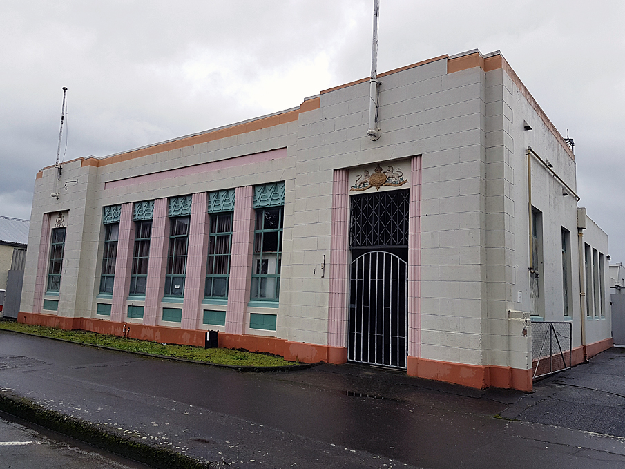
Post Office (Former) is a large, single-storey, painted reinforced concrete building, which features design elements typical in Mair’s work at the time, such as Stripped Classical pilasters and symmetry on the front façade, with some Art Deco inspired panels above its sizeable windows. The integrity of the materials and form of the building is high, due to it undergoing few alterations apart from the removal of a partition wall in the main section of the building, an extension to the toll exchange room at the rear of the building, and this area’s recent conversion into a residential space. Remnants of the building’s former use also remain, such as telephone booths and a mail availability indicator board.
Because it was a post office under the Post Office Department, Post Office (Former) has significance as a vestige of this department’s historical importance due to its dominance of the communications sector in New Zealand until the late twentieth century. As such, the building also has local social value because it connected people through its services, but also informally because it was a central gathering point. Architecturally, Post Office (Former) is a representative example of the work of the important Government Architect, John Thomas Mair, and because the building also retains a high level of integrity it is of architectural significance.
List Entry Information
Status
Listed
List Entry Status
Historic Place Category 2
Access
Private/No Public Access
List Number
4022
Date Entered
15th April 2011
Date of Effect
15th April 2011
City/District Council
Tararua District
Region
Horizons (Manawatū-Whanganui) Region
Extent of List Entry
Extent includes the land described as Lot 2 DP 82314 (RT WN48D/879), Wellington Land District and the building known as Post Office (Former) thereon, and its fittings and fixtures. (Refer to map in Appendix 1 of the registration report for further information).
Legal description
Lot 2 DP 82314 (RT WN48D/879), Wellington Land District
Location Description
State Highway 2 leads onto Main Street at the northeast and southwest ends of Pahiatua. Post Office (Former) is positioned one building southwest of the Main Street and Mangahao Road intersection, approximately halfway along Main Street in the central business area of Pahiatua.
Why is this place significant?
Cultural Significance
Social Significance or Value: As the main communications centre for Pahiatua and the surrounding district from the 1930s, Post Office (Former) was perhaps one of the most important buildings to the social fabric of the town because it was the conduit connecting people within the town, regionally, nationally, and internationally. Other than postal and telecommunications services, the post office also provided banking and other financial services, and as such it was a high use building where people would meet or dial into the toll exchange for informal socialising. The toll exchange aspect of the building imbues it with further social value because in the building’s early decades the exchange was an integral social service in times of crisis, coordinating and disseminating emergency information.
Historic Significance
Historical Significance or Value After the uneasy early relationship between Pahiatua and central government, the construction of Post Office (Former) is indicative that by the 1930s the privately established town had developed into the main service centre in the district, which was recognised by government through the building of an impressive new post office in Pahiatua. This building also has considerable local historical importance as the central hub of communications for the district for 50 years, not only being the main mail centre but also a base for telecommunications. The late twentieth century transfer of the building into the hands of the newly formed Telecom Corporation Limited also has historical value because it represents the broader economic and political situation in New Zealand at the time which led to the disbanding of the Post Office Department into state owned enterprises and the redistribution of its assets and functions.
Physical Significance
Architectural Significance or Value: With its Stripped Classical elements augmented by Art Deco touches, Post Office (Former) is a building characteristic of its construction period and purpose. Post Office (Former) also has significance as a typical example of a building designed by John Thomas Mair in his important role as Government Architect. This building has further value because it has retained a significant amount of its original fabric due to the limited number, and extent, of alterations since its construction was completed in 1937.
Why is this place Category 1 / Category 2?
Detail Of Assessed Criteria
(a) The extent to which the place reflects important or representative aspects of New Zealand history Post Office (Former) is representative of the ascendancy of the Post Office Department in New Zealand’s communication sector until the late twentieth century. In Pahiatua, as elsewhere in New Zealand, this was demonstrated by the early establishment of postal services and the various building projects undertaken by the department to expand its capacity in the town as it, and the wider area’s, population grew and communication technologies developed. By the 1930s, when Post Office (Former) was constructed, telecommunications were a well established branch of the department’s activities and as such these facilities were integrated into the design of Post Office (Former). The building’s loss of function was a result of the political and economic situation of the late 1980s which saw the beginnings of corporatisation of some operations traditionally undertaken by the state, which is another important aspect of New Zealand’s history. (b) The association of the place with events, persons, or ideas of importance in New Zealand history John Thomas Mair was the architect of Post Office (Former) and as such the building has importance because of its association with him in his role as Government Architect. Post Office (Former) has further value because it is a characteristic Mair public building, particularly in its combination of Stripped Classical style and Art Deco features, and its construction in reinforced concrete, which on the main façade was decoratively given the appearance of masonry. (g) The technical accomplishment or value, or design of the place The form and features of Post Office (Former) demonstrate design fidelity to the precepts of the Stripped Classical architecture in New Zealand. This building is a confident expression of this architectural style and therefore Post Office (Former) is of value as an accomplishment in this form of design. Summary of Significance or Values This place was assessed against, and found to qualify under the following criteria: a, b and g. Conclusion It is considered that this place qualifies as a Category II historic place.
Construction Professional
Name
Mair, John Thomas
Type
Architect
Biography
John Thomas Mair (1876-1959) was born in Invercargill and began his career with the New Zealand Railways on the staff of the Office Engineer, George Troup. In 1906 he travelled to the United States of America where he studied architecture at the University of Pennsylvania. He then worked in the office of George B. Post in New York before travelling to England where he was admitted as an Associate of the Royal Institute of British Architects. He became a Fellow in 1940. On his return to New Zealand he entered private practice, one of his first buildings being the Presbyterian First Church, Invercargill (1915), a prominent building of Romanesque character. He then practised in Wellington, carrying out largely domestic commissions. In 1918 he was appointed Inspector of Military Hospitals by the Defence Department, and in 1920 he became architect to the Department of Education. Following the retirement of John Campbell in 1922, Mair was appointed Government Architect, a position which he held until his retirement in 1942. During this period he was responsible for a variety of buildings, including the Courthouse, Hamilton, the Post Office in High Street, Christchurch, Government Life Office and the Departmental Building, both in Wellington, and the Jean Batten Building, Auckland. Such buildings show a departure from tradition, with the emphasis on function, structure and volume as opposed to a stylistic treatment of the building fabric. A Fellow of the New Zealand Institute of Architects, Mair was made a Life Member in 1942. His son John Lindsay Mair also practised as an architect.
Construction Details
Start Year
1935
Type
Original Construction
Description
Construction begins
Finish Year
1937
Type
Original Construction
Description
Construction completed
Start Year
1961
Type
Modification
Description
Toll room extended
Start Year
2010
Type
Modification
Description
Residence created in former toll room
Construction Materials
Concrete, brick, reinforced concrete, timber
The discovery and settlement of the Wairarapa region is connected with several prominent figures of New Zealand’s history. Ancestral figures such as Hau-nui-a-nanaia, Kupe, Whatonga, Tara Ika and Toi have all been said to have connections with the region and are responsible for the naming of many of the Wairarapa’s features and places. It has been estimated that Rangitane settled in the region by about the sixteenth century. Marriage links with Rangitane saw a group of Ngati Kahungunu retreat to the Wairarapa in the subsequent century as the result of internal hapu conflicts. The groups cohabitated mostly in the south Wairarapa for a period, but then the Ngati Kahungunu newcomers negotiated several sections of land for themselves. This process was not seamless and instances of conflict continued between the two iwi over the centuries. The next significant period of change in the area was in the early nineteenth century with the progression of Te Rauparaha and others. This ushered in an era when many different iwi, including Ngati Whatua, Ngati Awa, Ngati Toa, Ngati Raukawa, Ngati Tama, and Ngati Mutunga, made advances into the region and some Ngati Kahungunu hapu withdrew. Several decades later European incursion into the Wairarapa began after the New Zealand Company’s Port Nicholson settlement was established. Based on the reports of the company’s exploring and surveying parties the southern Wairarapa became one of the first extensive tracts of land to be occupied by Europeans, although the Crown titles, negotiated by Donald McLean, were not obtained until 1853. However, it took substantially longer for settlement to progress beyond Masterton, which was linked to Wellington by road in 1859. Further incursion was slow because the northern Wairarapa was heavily forested. In particular, the forest north of Mount Bruce was dense with rimu, tawa, matai, maire, kahikatea, and rata, and was known as Forty Mile Bush, which was within the larger Seventy Mile Bush that also encompassed the area as far north as Dannevirke and Norsewood. Maori referred to this forest as Te Tapere Nui o Whatonga (The great forest of Whatonga) and an abundance of birdlife resided there amongst giant ancient trees, some of which were large enough for groups of local Maori to shelter within their trunks. The forest acted as a significant barrier and therefore, while there was some European settlement in the northern Wairarapa before the late nineteenth century, it was not until roads were extended further and the railway link to Wellington established that the area was opened up for substantive settlement. In preparation for the construction of railway the government had an active role in the foundation of several places in the region. Towns such as Mauriceville, Eketahuna, Norsewood, and Dannevirke were all initially formed as bases for the labourers. Part of the preparation for railway construction included clearing the forest and building a road through the district which had progressed by the mid to late 1870s. This increased, albeit rudimentary, access meant that land sales in the Pahiatua area earnestly began in the early 1880s. An initially slow sales market was boosted greatly by purchases made on behalf of Arthur James Balfour (1848-1930), who later went onto become British Prime Minister and Earl Balfour. In this way, when Pahiatua township was eventually established in 1881 it differed from most of the other settlements in the area because it was not created by the Crown; instead it resulted from private subdivisions of land. The site of Pahiatua had previously been a Maori village called Te Pohatu. It is thought that Pahiatua’s founder, Masterton nurseryman William Wilson McCardle (1844-1921), named the township after his friend and local Maori Chief, Koneke Pahiatua. Pahiatua, which means resting place, or camp, of the atua refers to a seventeenth century event when an atua rescued a Rangitane chief from invading forces to the south. Once the private subdivisions were made, Pahiatua quickly emerged as a frontrunner to become the main service centre of the area, which attracted further settlement and businesses to the town. By the mid 1880s local tenacity meant that the burgeoning town of about 500 people had shops, a hotel, and a Road Board, but had been by-passed by the railway despite Main Street having been specifically made unusually wide to compensate for the potential railway line down its centre. The fact that Main Street was prone to flooding was a valid reason for the government engineer to recommend the railway tracks be laid west of the town, but Pahiatua people saw this as a deliberate snub. Because it was a privately created town Pahiatua was slow to accrue many of the public facilities that were established comparatively early in other towns. However, the rapid growth of the town and wider area led to the creation of the Pahiatua County Council in 1888 and the Pahiatua Borough in 1892. Most of the early activity of the County Council seems to have been focused on petitioning the government to create public institutions in Pahiatua. Although a state school had already been opened by the time the council came into effect, it took years of pressure for other institutions to be granted to Pahiatua. For example it was not until 1894 that the town received its first permanent police officer. This seems to have been an auspicious year for Pahiatua because it was also in 1894 that the town was granted its first purpose-built Post Office. Prior to this the post office had operated out of local shops, and then was based at the railway station several kilometres from the town centre. In 1908 Pahiatua was described as a ‘rising town.’ It was probably in recognition of this growth that the existing late nineteenth century post office building was substantially extended in 1905, before being completely replaced with a new timber one constructed in 1908 on the corner of Main and King Streets. However, within 20 years it was recognised that this building was insufficient for a town the size of Pahiatua, and as such a large site in central Main Street was purchased in 1926. However, the tenders to erect a new Post Office were not called for until late 1935. Pahiatua’s new post office was designed by John Thomas Mair (1876-1959) in his role as Government Architect, and construction began in 1935. Indeed, Post Office (Former) is typical of his public buildings during the 1930s in that it is a Stripped Classical building with some Art Deco decorative features. Opened on 14 May 1937 by the Postmaster General, Hon. Frederick Jones (1884-1966), the new Post Office cost the reasonably substantial sum of £7,000. Like many post offices of its size around New Zealand, the Post Office was not only a place to post and collect mail. Throughout much of the twentieth century the Post Office Department was responsible for post and telecommunications, as well as providing banking and funds transfer facilities. This meant that post office buildings were busy places, often teeming with people undertaking their everyday business. As well as the various communications and money services which were based in Post Office (Former), there was also a toll exchange in the building. The staff in the exchange connected telephone calls to other exchanges around the country and administered the relevant charges for the toll calls. However, their role often extended beyond formal duties, for example the ‘toll girls’ were also a good unofficial source of local and national news. One toll exchange employee from the 1930s remembered summer being a particularly busy time at the exchange, with people calling in order to get updates on the various cricket matches happening nationally. The exchange was also vital as a key means of organising emergency services, as well as spreading information about floods and other hazards. A few decades after Post Office (Former) was built the remainder of the section was taken up by a large telephone exchange constructed at the rear of the site in 1957. This was a separate building but was close enough to the Post Office for the two to be linked by a passageway. The automatic exchange equipment installed in the new building was described as the most modern in the country, but the toll exchange continued to operate out of the Post Office. After 1960 the toll room was extended, nearly doubling its original size. In 1987 the Post Office Department was broken up into New Zealand Post Limited, Postbank Limited, and Telecom Corporation Limited. Given that the larger part of the buildings at the Post Office site were occupied by telecommunications operations it was Telecom that took ownership of the property, at which time the post office moved out of its 1937 building and the toll exchange also ceased soon after. In 1989 it seems that Telecom desired to convert the former post office area into offices with a new large central entranceway created by removing most of the pilasters and other details from the centre of the front façade. Earlier in 1985 the Post Office Department had similarly proposed eliminating the front windows and Art Deco decorative panels, replacing them with full length glazing sheltered by a diagonal glass verandah. The New Zealand Historic Places Trust was not in favour of the proposal as it stood and the Post Office Department agreed to reassess the matter, however no further action was taken. In 1996 the former Post Office was sold into private ownership, but the Telephone Exchange was retained by Telecom. Recently the toll exchange has been converted into a residence while the main section of the building is currently unoccupied.
The discovery and settlement of the Wairarapa region is connected with several prominent figures of New Zealand’s history. Ancestral figures such as Hau-nui-a-nanaia, Kupe, Whatonga, Tara Ika and Toi have all been said to have connections with the region and are responsible for the naming of many of the Wairarapa’s features and places. It has been estimated that Rangitane settled in the region by about the sixteenth century. Marriage links with Rangitane saw a group of Ngati Kahungunu retreat to the Wairarapa in the subsequent century as the result of internal hapu conflicts. The groups cohabitated mostly in the south Wairarapa for a period, but then the Ngati Kahungunu newcomers negotiated several sections of land for themselves. This process was not seamless and instances of conflict continued between the two iwi over the centuries. The next significant period of change in the area was in the early nineteenth century with the progression of Te Rauparaha and others. This ushered in an era when many different iwi, including Ngati Whatua, Ngati Awa, Ngati Toa, Ngati Raukawa, Ngati Tama, and Ngati Mutunga, made advances into the region and some Ngati Kahungunu hapu withdrew. Several decades later European incursion into the Wairarapa began after the New Zealand Company’s Port Nicholson settlement was established. Based on the reports of the company’s exploring and surveying parties the southern Wairarapa became one of the first extensive tracts of land to be occupied by Europeans, although the Crown titles, negotiated by Donald McLean, were not obtained until 1853. However, it took substantially longer for settlement to progress beyond Masterton, which was linked to Wellington by road in 1859. Further incursion was slow because the northern Wairarapa was heavily forested. In particular, the forest north of Mount Bruce was dense with rimu, tawa, matai, maire, kahikatea, and rata, and was known as Forty Mile Bush, which was within the larger Seventy Mile Bush that also encompassed the area as far north as Dannevirke and Norsewood. Maori referred to this forest as Te Tapere Nui o Whatonga (The great forest of Whatonga) and an abundance of birdlife resided there amongst giant ancient trees, some of which were large enough for groups of local Maori to shelter within their trunks. The forest acted as a significant barrier and therefore, while there was some European settlement in the northern Wairarapa before the late nineteenth century, it was not until roads were extended further and the railway link to Wellington established that the area was opened up for substantive settlement. In preparation for the construction of railway the government had an active role in the foundation of several places in the region. Towns such as Mauriceville, Eketahuna, Norsewood, and Dannevirke were all initially formed as bases for the labourers. Part of the preparation for railway construction included clearing the forest and building a road through the district which had progressed by the mid to late 1870s. This increased, albeit rudimentary, access meant that land sales in the Pahiatua area earnestly began in the early 1880s. An initially slow sales market was boosted greatly by purchases made on behalf of Arthur James Balfour (1848-1930), who later went onto become British Prime Minister and Earl Balfour. In this way, when Pahiatua township was eventually established in 1881 it differed from most of the other settlements in the area because it was not created by the Crown; instead it resulted from private subdivisions of land. The site of Pahiatua had previously been a Maori village called Te Pohatu. It is thought that Pahiatua’s founder, Masterton nurseryman William Wilson McCardle (1844-1921), named the township after his friend and local Maori Chief, Koneke Pahiatua. Pahiatua, which means resting place, or camp, of the atua refers to a seventeenth century event when an atua rescued a Rangitane chief from invading forces to the south. Once the private subdivisions were made, Pahiatua quickly emerged as a frontrunner to become the main service centre of the area, which attracted further settlement and businesses to the town. By the mid 1880s local tenacity meant that the burgeoning town of about 500 people had shops, a hotel, and a Road Board, but had been by-passed by the railway despite Main Street having been specifically made unusually wide to compensate for the potential railway line down its centre. The fact that Main Street was prone to flooding was a valid reason for the government engineer to recommend the railway tracks be laid west of the town, but Pahiatua people saw this as a deliberate snub. Because it was a privately created town Pahiatua was slow to accrue many of the public facilities that were established comparatively early in other towns. However, the rapid growth of the town and wider area led to the creation of the Pahiatua County Council in 1888 and the Pahiatua Borough in 1892. Most of the early activity of the County Council seems to have been focused on petitioning the government to create public institutions in Pahiatua. Although a state school had already been opened by the time the council came into effect, it took years of pressure for other institutions to be granted to Pahiatua. For example it was not until 1894 that the town received its first permanent police officer. This seems to have been an auspicious year for Pahiatua because it was also in 1894 that the town was granted its first purpose-built Post Office. Prior to this the post office had operated out of local shops, and then was based at the railway station several kilometres from the town centre. In 1908 Pahiatua was described as a ‘rising town.’ It was probably in recognition of this growth that the existing late nineteenth century post office building was substantially extended in 1905, before being completely replaced with a new timber one constructed in 1908 on the corner of Main and King Streets. However, within 20 years it was recognised that this building was insufficient for a town the size of Pahiatua, and as such a large site in central Main Street was purchased in 1926. However, the tenders to erect a new Post Office were not called for until late 1935. Pahiatua’s new post office was designed by John Thomas Mair (1876-1959) in his role as Government Architect, and construction began in 1935. Indeed, Post Office (Former) is typical of his public buildings during the 1930s in that it is a Stripped Classical building with some Art Deco decorative features. Opened on 14 May 1937 by the Postmaster General, Hon. Frederick Jones (1884-1966), the new Post Office cost the reasonably substantial sum of £7,000. Like many post offices of its size around New Zealand, the Post Office was not only a place to post and collect mail. Throughout much of the twentieth century the Post Office Department was responsible for post and telecommunications, as well as providing banking and funds transfer facilities. This meant that post office buildings were busy places, often teeming with people undertaking their everyday business. As well as the various communications and money services which were based in Post Office (Former), there was also a toll exchange in the building. The staff in the exchange connected telephone calls to other exchanges around the country and administered the relevant charges for the toll calls. However, their role often extended beyond formal duties, for example the ‘toll girls’ were also a good unofficial source of local and national news. One toll exchange employee from the 1930s remembered summer being a particularly busy time at the exchange, with people calling in order to get updates on the various cricket matches happening nationally. The exchange was also vital as a key means of organising emergency services, as well as spreading information about floods and other hazards. A few decades after Post Office (Former) was built the remainder of the section was taken up by a large telephone exchange constructed at the rear of the site in 1957. This was a separate building but was close enough to the Post Office for the two to be linked by a passageway. The automatic exchange equipment installed in the new building was described as the most modern in the country, but the toll exchange continued to operate out of the Post Office. After 1960 the toll room was extended, nearly doubling its original size. In 1987 the Post Office Department was broken up into New Zealand Post Limited, Postbank Limited, and Telecom Corporation Limited. Given that the larger part of the buildings at the Post Office site were occupied by telecommunications operations it was Telecom that took ownership of the property, at which time the post office moved out of its 1937 building and the toll exchange also ceased soon after. In 1989 it seems that Telecom desired to convert the former post office area into offices with a new large central entranceway created by removing most of the pilasters and other details from the centre of the front façade. Earlier in 1985 the Post Office Department had similarly proposed eliminating the front windows and Art Deco decorative panels, replacing them with full length glazing sheltered by a diagonal glass verandah. The New Zealand Historic Places Trust was not in favour of the proposal as it stood and the Post Office Department agreed to reassess the matter, however no further action was taken. In 1996 the former Post Office was sold into private ownership, but the Telephone Exchange was retained by Telecom. Recently the toll exchange has been converted into a residence while the main section of the building is currently unoccupied.
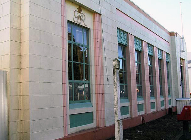
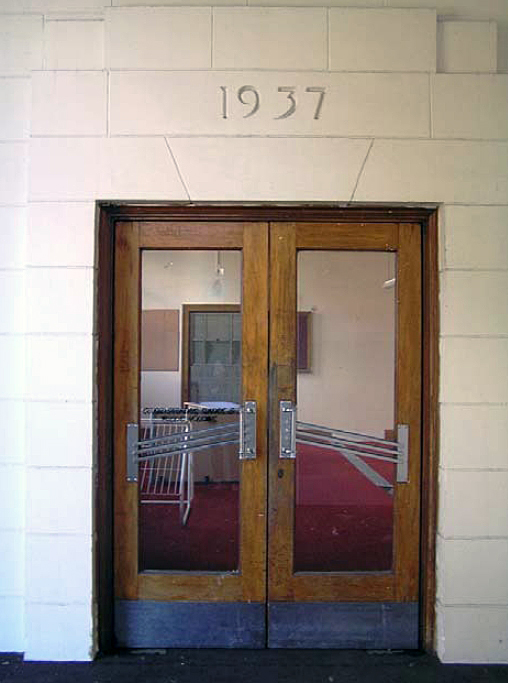
Post Office (Former) has been described as a Style 1P post office, which indicates it is a single storey, government designed building, constructed in permanent materials, in this case reinforced concrete. Post Office (Former) is located in the central business area of Pahiatua and, despite being a single level building, has a strong presence on the northwest side of Main Street and immediately abuts the footpath. The building has a high stud and therefore its uninterrupted decorative façade is striking in comparison to most of the commercial buildings that surround it, which are generally simple single storey buildings with verandahs. An exception to this is Bank of New South Wales (Former), the northern neighbour of Post Office (Former). Dating from 1912, this bank building is of a similar height to Post Office (Former) and its Italianate decorative features create an interesting contrast with the pared-back Stripped Classical styling of the post office building. Occupying much of its current land parcel, there is a narrow driveway between Post Office (Former) and the bank building on its north boundary. This driveway leads past the main rectangular bulk of the post office building before opening out slightly into a loading and utility area. Previously the driveway also provided access to the Telephone Exchange building, which is only separated from the rear of Post Office (Former) by a gap of approximately two metres. These two buildings historically were linked by an enclosed walkway, however this was removed and a high boundary fence erected in the late twentieth century when Post Office (Former) was sold by the current owners of the Telephone Exchange. In general Post Office (Former) is an austere building on its exterior. However, the main façade of the building exhibits Stripped Classical features, with some decorative Art Deco elements, characteristic of Mair’s public buildings from this period. The street front of Post Office (Former) is symmetrical in its form and decorative features, including its kauri flagpoles, with the only divergence from this formula being aspects of the outer, slightly projected, full height bays. The southernmost bay features a window framed by quarter column pilasters and the plaster insignia of King George VI, while on the opposing northern bay the window opening has been extended to the ground creating the access to the building’s lobby, which is capped by New Zealand’s coat of arms. Previously the banner above the main group of front windows contained the original name of the building. However this has subsequently been removed, presumably to eliminate confusion among the public looking for the current Post Office. The decorative elements of the building continue between the bays with fluted pilasters interspersed between a series of five large multi-paned windows, whose lower panes are predominantly frosted. The middle upper panes of these windows are hinged at the top and open outwards. Immediately above each window is a decorative Art Deco relief panel featuring three graduating triangles which segment a wave pattern. Beneath the windows are recessed plain panels. These features, as well as the building’s abbreviated parapet, have been highlighted with paint. However, originally the building was not painted and this treatment only seems to have started in the mid to late twentieth century. A further decorative element of the front elevation is the thick plastered surface which has been pointed in order to create a masonry effect. This plastering imbues the reinforced concrete building with characteristics associated with masonry buildings: an air of grandeur, formality and permanence. Along with the style of the building, this technique was typical in Mair’s public buildings from the period, such as the Palmerston North Police Station (Former). Through the opening in the front façade, which has an upper grille and lower steel gate, this plastered masonry effect is continued into the lobby where the opening plaque is located and ‘1937’ is inscribed into the plaster above the main entrance of the building. As well as these glazed timber-framed double doors with diagonal chrome handles that span the width of each, there is also an entrance in the northwest side of the lobby. Previously, this was the access point for the private box and package collection area, which still has its mail delivery indicator above the opening which leads through to the former mail sorting area. Inside the main entrance is what used to be the public area of the post office, and to the left of the doors are a couple of original timber telephone booths. At the opposite end of the public space is the former manager’s office, which retains its rimu skirting and picture rail. Rimu is used frequently elsewhere in the building for the trimmings and architraves, such as in the frames of the windows topping the partitioning wall that divided the public and mail sorting areas. Like the other internal partitions, this wall is constructed from brick faced with plaster. The current partition wall which defines the public area was originally repeated, completely enclosing the space. However, this had been removed by the late twentieth century creating the present open plan flow through to what was formerly the mail room. This rear section of the main part of the building is a large open area with a loading bay door close to its north corner. The mail sorting area has several smaller rooms adjoining it, such as the former staff and stationary rooms on the southwest end, the strong room, and former operations room, the latter being the only timber floored room in the building as it is located above the basement. The strong room and operations room adjoin a passageway that originally ran the remaining length of the building, providing staff access to the bathrooms and toll room. The adjacent male and female bathrooms feature tiling which is most likely original. Recently the passageway was blocked off, establishing an enclosed residence in the former toll room at the rear of the building. As such the ladies toilet is now isolated from its counterpart. A set of aluminium framed double doors provides access to the residence. Internal partitions have also been installed to create bedrooms.
Post Office (Former) has been described as a Style 1P post office, which indicates it is a single storey, government designed building, constructed in permanent materials, in this case reinforced concrete. Post Office (Former) is located in the central business area of Pahiatua and, despite being a single level building, has a strong presence on the northwest side of Main Street and immediately abuts the footpath. The building has a high stud and therefore its uninterrupted decorative façade is striking in comparison to most of the commercial buildings that surround it, which are generally simple single storey buildings with verandahs. An exception to this is Bank of New South Wales (Former), the northern neighbour of Post Office (Former). Dating from 1912, this bank building is of a similar height to Post Office (Former) and its Italianate decorative features create an interesting contrast with the pared-back Stripped Classical styling of the post office building. Occupying much of its current land parcel, there is a narrow driveway between Post Office (Former) and the bank building on its north boundary. This driveway leads past the main rectangular bulk of the post office building before opening out slightly into a loading and utility area. Previously the driveway also provided access to the Telephone Exchange building, which is only separated from the rear of Post Office (Former) by a gap of approximately two metres. These two buildings historically were linked by an enclosed walkway, however this was removed and a high boundary fence erected in the late twentieth century when Post Office (Former) was sold by the current owners of the Telephone Exchange. In general Post Office (Former) is an austere building on its exterior. However, the main façade of the building exhibits Stripped Classical features, with some decorative Art Deco elements, characteristic of Mair’s public buildings from this period. The street front of Post Office (Former) is symmetrical in its form and decorative features, including its kauri flagpoles, with the only divergence from this formula being aspects of the outer, slightly projected, full height bays. The southernmost bay features a window framed by quarter column pilasters and the plaster insignia of King George VI, while on the opposing northern bay the window opening has been extended to the ground creating the access to the building’s lobby, which is capped by New Zealand’s coat of arms. Previously the banner above the main group of front windows contained the original name of the building. However this has subsequently been removed, presumably to eliminate confusion among the public looking for the current Post Office. The decorative elements of the building continue between the bays with fluted pilasters interspersed between a series of five large multi-paned windows, whose lower panes are predominantly frosted. The middle upper panes of these windows are hinged at the top and open outwards. Immediately above each window is a decorative Art Deco relief panel featuring three graduating triangles which segment a wave pattern. Beneath the windows are recessed plain panels. These features, as well as the building’s abbreviated parapet, have been highlighted with paint. However, originally the building was not painted and this treatment only seems to have started in the mid to late twentieth century. A further decorative element of the front elevation is the thick plastered surface which has been pointed in order to create a masonry effect. This plastering imbues the reinforced concrete building with characteristics associated with masonry buildings: an air of grandeur, formality and permanence. Along with the style of the building, this technique was typical in Mair’s public buildings from the period, such as the Palmerston North Police Station (Former). Through the opening in the front façade, which has an upper grille and lower steel gate, this plastered masonry effect is continued into the lobby where the opening plaque is located and ‘1937’ is inscribed into the plaster above the main entrance of the building. As well as these glazed timber-framed double doors with diagonal chrome handles that span the width of each, there is also an entrance in the northwest side of the lobby. Previously, this was the access point for the private box and package collection area, which still has its mail delivery indicator above the opening which leads through to the former mail sorting area. Inside the main entrance is what used to be the public area of the post office, and to the left of the doors are a couple of original timber telephone booths. At the opposite end of the public space is the former manager’s office, which retains its rimu skirting and picture rail. Rimu is used frequently elsewhere in the building for the trimmings and architraves, such as in the frames of the windows topping the partitioning wall that divided the public and mail sorting areas. Like the other internal partitions, this wall is constructed from brick faced with plaster. The current partition wall which defines the public area was originally repeated, completely enclosing the space. However, this had been removed by the late twentieth century creating the present open plan flow through to what was formerly the mail room. This rear section of the main part of the building is a large open area with a loading bay door close to its north corner. The mail sorting area has several smaller rooms adjoining it, such as the former staff and stationary rooms on the southwest end, the strong room, and former operations room, the latter being the only timber floored room in the building as it is located above the basement. The strong room and operations room adjoin a passageway that originally ran the remaining length of the building, providing staff access to the bathrooms and toll room. The adjacent male and female bathrooms feature tiling which is most likely original. Recently the passageway was blocked off, establishing an enclosed residence in the former toll room at the rear of the building. As such the ladies toilet is now isolated from its counterpart. A set of aluminium framed double doors provides access to the residence. Internal partitions have also been installed to create bedrooms.
Historical and Associated Iwi / Hapū / Whānau
Completion Date
15th October 2010
Report Written By
Karen Astwood
Information Sources
Bagnall, 1976
A. G. Bagnall, Wairarapa; An Historical Excursion, Trentham, 1976
Cyclopedia of New Zealand, 1908
Cyclopedia Company, Industrial, descriptive, historical, biographical facts, figures, illustrations, Wellington, N.Z, 1897-1908, Vol. 6, Taranaki, Hawke's Bay, Wellington, 1908
McLintock, 1966
An Encyclopedia of New Zealand, Government Printer, Wellington, 1966
Grant, 1995
Grant, I.F., North of the Waingawa: The Masterton Borough and County Councils, 1877-1989, Masterton, 1995
Clulee, 2009
I, Clulee, Post Office Buildings in the Lower North Island, Auckland, 2009
Other Information
A fully referenced registration report is available from the NZHPT Central Region office Please note that entry on the New Zealand Heritage List/Rarangi Korero identifies only the heritage values of the property concerned, and should not be construed as advice on the state of the property, or as a comment of its soundness or safety, including in regard to earthquake risk, safety in the event of fire, or insanitary conditions.
Current Usages
Uses: Accommodation
Specific Usage: Studio/granny flat
Former Usages
General Usage: Communication
Specific Usage: Post Office
General Usage: Communication
Specific Usage: Postal Sorting & Distribution Centre
General Usage: Communication
Specific Usage: Telephone Exchange
Current Usages
Uses: Accommodation
Specific Usage: Studio/granny flat
Former Usages
General Usage: Communication
Specific Usage: Post Office
General Usage: Communication
Specific Usage: Postal Sorting & Distribution Centre
General Usage: Communication
Specific Usage: Telephone Exchange
Location
Sign up to hear more
Get the latest heritage news, features and events delivered
straight to your inbox.
