

List Entry Information
Status
Listed
List Entry Status
Historic Place Category 1
Access
Private/No Public Access
List Number
4726
Date Entered
19th April 1990
Date of Effect
19th April 1990
City/District Council
Dunedin City
Region
Otago Region
Legal description
Lot 5 DP 389391 (RT 360774), Pt Sec 51 and Sec 52 Blk I Lower Harbour West SD (RT OT299/247), Sec 55 Block I Lower Harbour West SD (RT 40978, NZ Gazette 1986, p. 4621), Sec 12 Blk II Andersons Bay SD (RT OT11B/1048), Secs 1-3, 5 SO 394230 (RTs 403802, 403815; NZ Gazette 2008, p. 188), Sec 14 Blk IV Andersons Bay SD (RT OT9A/219), Sec 64 Upper Harbour East SD (RT 40977), Secs 1-2 SO 23874 (RT 37632), Seabed, Legal Road, Railway Land, Otago Land District.
Status
Listed
List Entry Status
Historic Place Category 1
Access
Private/No Public Access
List Number
4726
Date Entered
19th April 1990
Date of Effect
19th April 1990
City/District Council
Dunedin City
Region
Otago Region
Legal description
Lot 5 DP 389391 (RT 360774), Pt Sec 51 and Sec 52 Blk I Lower Harbour West SD (RT OT299/247), Sec 55 Block I Lower Harbour West SD (RT 40978, NZ Gazette 1986, p. 4621), Sec 12 Blk II Andersons Bay SD (RT OT11B/1048), Secs 1-3, 5 SO 394230 (RTs 403802, 403815; NZ Gazette 2008, p. 188), Sec 14 Blk IV Andersons Bay SD (RT OT9A/219), Sec 64 Upper Harbour East SD (RT 40977), Secs 1-2 SO 23874 (RT 37632), Seabed, Legal Road, Railway Land, Otago Land District.
Why is this place significant?
Historic Significance
Historical Significance or Value The wall on the Peninsula side of the harbour from Vauxhall to Broad Bay was built by private contractors working for the Otago Provincial Council. The Portobello Road Board made a few kilometres in Broad Bay and Portobello Bay. After 1877 the government used prison labour on the rest of the Broad Bay to Taiaroa Head Road. It is likely that the Army built the very fine stonework on Pilots beach and Harington Point. On the Port Chalmers side, the road from Careys Bay to Otafelo Point was mostly formed by prison labour transported daily by train from 1872 to 1880. It was extensively repaired by relief labour during the 1930s. Between Port Chalmers and Dunedin the railway originally ran round all the bays and in the 1930s a start was made on realigning it on causeways across the bays. Work ceased during the 1939-45 war and the line was not opened until 1948. After its opening the Dunedin-Port Chalmers Road was realigned for much of its length on the old rail embankment. Consequently its revetments near St Leonards and around Arden Bay were built for the railway line in 1870-72. The railway revetments vary from older near Dunedin to the 1930s causeways across Arden Bay.
Physical Significance
ARCHITECTURAL SIGNIFICANCE: A massive example of this type of vernacular stone work in New Zealand. The walls total about 37 kilometres (19.4 km on the east side of the harbour, 8.3 km from Port Chalmers to Aramoana, 1.3 km around back beach, and about 8.5 km of old and current railway causeways). TOWNSCAPE/LANDMARK SIGNIFICANCE: The seawalls are an important part of the historic landscape of the harbour edge.
Why is this place significant?
Historic Significance
Historical Significance or Value The wall on the Peninsula side of the harbour from Vauxhall to Broad Bay was built by private contractors working for the Otago Provincial Council. The Portobello Road Board made a few kilometres in Broad Bay and Portobello Bay. After 1877 the government used prison labour on the rest of the Broad Bay to Taiaroa Head Road. It is likely that the Army built the very fine stonework on Pilots beach and Harington Point. On the Port Chalmers side, the road from Careys Bay to Otafelo Point was mostly formed by prison labour transported daily by train from 1872 to 1880. It was extensively repaired by relief labour during the 1930s. Between Port Chalmers and Dunedin the railway originally ran round all the bays and in the 1930s a start was made on realigning it on causeways across the bays. Work ceased during the 1939-45 war and the line was not opened until 1948. After its opening the Dunedin-Port Chalmers Road was realigned for much of its length on the old rail embankment. Consequently its revetments near St Leonards and around Arden Bay were built for the railway line in 1870-72. The railway revetments vary from older near Dunedin to the 1930s causeways across Arden Bay.
Physical Significance
ARCHITECTURAL SIGNIFICANCE: A massive example of this type of vernacular stone work in New Zealand. The walls total about 37 kilometres (19.4 km on the east side of the harbour, 8.3 km from Port Chalmers to Aramoana, 1.3 km around back beach, and about 8.5 km of old and current railway causeways). TOWNSCAPE/LANDMARK SIGNIFICANCE: The seawalls are an important part of the historic landscape of the harbour edge.
Construction Details
Start Year
1865
Finish Year
1880
Type
Original Construction
Construction Materials
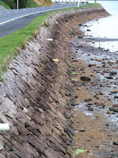
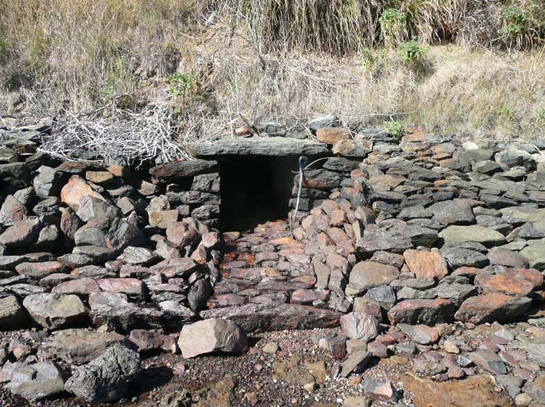
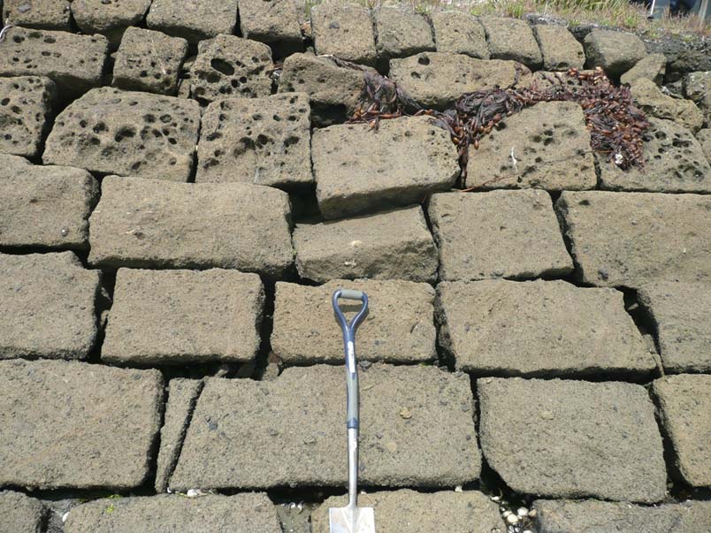
The road walls are dry stone revetments, backed by about 60cm of small stone rubble. They vary in height from 1.5 to 3.0 metres but are most commonly about 2 metres high. The pitch varies from 35 to 85 degrees but is most commonly 40-50 degrees and usually even from top to bottom of the wall. The stones are not brought to course and are poorly graded, but the face is very even, the joints well crossed and where well built and maintained, very stable. There are a few stone lined culverts and with stone lintels 1 metre long, which deliver stormwater and creeks from the other side of the road on to the beach. These are presumably the original culverts, most of which have been replaced with earthenware or concrete pipes. The rock used on the Portobello-Harrington Point Road is the local rock that has been quarried into in order to form the road. This rock varies from pink breccias to dark gray basalts. The rock used for the Aramoana Road is also the local volcanics but includes more grey Port Chalmers breccia. The stones were generally cleaved until they showed a suitable face and do not appear to have been trimmed by flaking. They are generally rather small - 50-20cm long and 10-22cm high. The wall is reasonably intact for about 32 kilometres around the harbour. The railway causeways are more massive, usually 3-4 metres high, a steeper pitch of 60-75 degrees, larger stones used, rougher face, stones not so well crossed on the more recent causeways, but well made and well chocked. They are built of Leith valley andesite and Port Chalmers breccia, the latter cleaving well into massive blocks. A photograph of the Arden Bay causeway under construction 19 November 1937, shows wooden profile frames in place to guide the wallers.
Notable Features
The length of the walls. They also represent a skill no longer generally available in the community.
Construction Details
Start Year
1865
Finish Year
1880
Type
Original Construction
Construction Materials
The road walls are dry stone revetments, backed by about 60cm of small stone rubble. They vary in height from 1.5 to 3.0 metres but are most commonly about 2 metres high. The pitch varies from 35 to 85 degrees but is most commonly 40-50 degrees and usually even from top to bottom of the wall. The stones are not brought to course and are poorly graded, but the face is very even, the joints well crossed and where well built and maintained, very stable. There are a few stone lined culverts and with stone lintels 1 metre long, which deliver stormwater and creeks from the other side of the road on to the beach. These are presumably the original culverts, most of which have been replaced with earthenware or concrete pipes. The rock used on the Portobello-Harrington Point Road is the local rock that has been quarried into in order to form the road. This rock varies from pink breccias to dark gray basalts. The rock used for the Aramoana Road is also the local volcanics but includes more grey Port Chalmers breccia. The stones were generally cleaved until they showed a suitable face and do not appear to have been trimmed by flaking. They are generally rather small - 50-20cm long and 10-22cm high. The wall is reasonably intact for about 32 kilometres around the harbour. The railway causeways are more massive, usually 3-4 metres high, a steeper pitch of 60-75 degrees, larger stones used, rougher face, stones not so well crossed on the more recent causeways, but well made and well chocked. They are built of Leith valley andesite and Port Chalmers breccia, the latter cleaving well into massive blocks. A photograph of the Arden Bay causeway under construction 19 November 1937, shows wooden profile frames in place to guide the wallers.
Notable Features
The length of the walls. They also represent a skill no longer generally available in the community.
DATE OF BUILDING: The road walls on the east side were built between 1865-1880. The road walls near St Leonards and at Blanket Bay are the old railway walls built before 1872. The road walls from Port Chalmers to Aramoana were built and rebuilt from 1872 through to the 1930s. The present railway causeways range from the 1870s close to Dunedin to 1937-48 close to Port Chalmers where new causeways were built. ARCHITECT/ENGINEER/DESIGNER: The Otago Provincial Roads and Works Engineers and their successors. The Railways Engineers. ARCHITECTURAL DESCRIPTION (STYLE): Simple vernacular dry stone revetments MODIFICATIONS: The road walls have required constant maintenance against wave action and are particularly vulnerable to overtopping by storm generated waves at high tide. They have been repaired by uneven replacement of the original stones, concrete mortar, concrete and asphalt topping and in places tipping of quarried basalt blocks to form a rubble slope. In recent years the City has repaired the walls by replacing the original stones but acknowledge that there is a lack of men with the skills of the 1870 wallers. The railway walls are not so vulnerable to overtopping and the main problem has been the washing out of fines from behind the facing stones, causing voids and collapse of the facing stones. The voids have been filled with chocking stones and bitumen poured down the faces over considerable stretches of the outer walls. Occasional cone shaped heaps of rubble have been used and there are rubble slopes in some places which may be original.
DATE OF BUILDING: The road walls on the east side were built between 1865-1880. The road walls near St Leonards and at Blanket Bay are the old railway walls built before 1872. The road walls from Port Chalmers to Aramoana were built and rebuilt from 1872 through to the 1930s. The present railway causeways range from the 1870s close to Dunedin to 1937-48 close to Port Chalmers where new causeways were built. ARCHITECT/ENGINEER/DESIGNER: The Otago Provincial Roads and Works Engineers and their successors. The Railways Engineers. ARCHITECTURAL DESCRIPTION (STYLE): Simple vernacular dry stone revetments MODIFICATIONS: The road walls have required constant maintenance against wave action and are particularly vulnerable to overtopping by storm generated waves at high tide. They have been repaired by uneven replacement of the original stones, concrete mortar, concrete and asphalt topping and in places tipping of quarried basalt blocks to form a rubble slope. In recent years the City has repaired the walls by replacing the original stones but acknowledge that there is a lack of men with the skills of the 1870 wallers. The railway walls are not so vulnerable to overtopping and the main problem has been the washing out of fines from behind the facing stones, causing voids and collapse of the facing stones. The voids have been filled with chocking stones and bitumen poured down the faces over considerable stretches of the outer walls. Occasional cone shaped heaps of rubble have been used and there are rubble slopes in some places which may be original.
Historical and Associated Iwi / Hapū / Whānau
Public NZAA Number
I44/302
Information Sources
Evening Star
Evening Star
Other Information
This historic place was registered under the Historic Places Act 1980. This report includes the text from the original Building Classification Committee report considered by the NZHPT Board at the time of registration. Please note that entry on the New Zealand Heritage List/Rarangi Korero identifies only the heritage values of the property concerned, and should not be construed as advice on the state of the property, or as a comment of its soundness or safety, including in regard to earthquake risk, safety in the event of fire, or insanitary conditions.
Historical and Associated Iwi / Hapū / Whānau
Public NZAA Number
I44/302
Information Sources
Evening Star
Evening Star
Other Information
This historic place was registered under the Historic Places Act 1980. This report includes the text from the original Building Classification Committee report considered by the NZHPT Board at the time of registration. Please note that entry on the New Zealand Heritage List/Rarangi Korero identifies only the heritage values of the property concerned, and should not be construed as advice on the state of the property, or as a comment of its soundness or safety, including in regard to earthquake risk, safety in the event of fire, or insanitary conditions.
Former Usages
General Usage: Civic Facilities
Specific Usage: Wall/Fence
Former Usages
General Usage: Civic Facilities
Specific Usage: Wall/Fence
Location
Sign up to hear more
Get the latest heritage news, features and events delivered
straight to your inbox.
