

People have inhabited Mohua (Golden Bay) for many centuries, valuing its climate and resources, including kōkōwai (red ochre), obtained from the foothills of Parapara, a maunga of great cultural importance to tangata whenua. The mineral richness of the Onekaka-Parapara hills was also recognised by early colonists, who moved quickly to secure this resource for the Crown. The Onakaka Iron and Steel Company was formed in 1920, consolidating various earlier mining leases that had not been fully realised. Forty men were employed to construct smelting works on a terrace to the west of State Highway 60. The plant was fully operational by 1924, producing bars of pig iron suitable for making railway irons, stoves and pipes.
The company infrastructure stretched from the hills to the coast at the Onekaka Inlet. Limonite (iron ore) and limestone was obtained from adjacent open-cast pits in the foothills; workers lived on site in huts. Then an aerial ropeway carried buckets 2.4 kilometres downhill to the ironworks. The raw materials were crushed, washed, mixed with coke produced on site, and smelted in a blast furnace. Good transport routes were necessary to get machinery and coal to the works, and the smelted iron products from there to domestic and international markets. A wharf was constructed at Onekaka Inlet and a tramline ran 2.6 kilometres directly from the wharf to the ironworks. In 1928-29, near to the quarries, a hydro-electric scheme consisting of a 10-metre-high concrete arch dam on the Onekaka River, a 1.25-kilometre-long penstock, and a powerhouse containing a Boving Pelton wheel, was built to power the ironworks’ new pipe-making plant.
The ironworks were a major employer in the area, and with over 81,000 tons of iron produced between 1922 and 1935, hopes were high for an enduring industry. However, ultimately the enterprise proved uneconomic, and the company was placed into receivership in 1931 before closure in 1935. Government efforts to revive the Onekaka industry ceased in 1954. The ironworks were dismantled, and bush reclaimed the quarries and the workers’ camp. However, the hydro-electric power scheme continued to be useful. The Golden Bay Electric Power Board utilised it to meet increased demand from 1937 until the Cobb Hydro-Scheme could supply all the load. In 2003 the dam gained a new lease of life when it was resurrected by Onekaka Energy Company Ltd, and it continues to supply power to the national grid.
List Entry Information
Status
Listed
List Entry Status
Historic Place Category 2
Access
Private/No Public Access
List Number
5120
Date Entered
16th December 2021
Date of Effect
26th January 2022
City/District Council
Tasman District
Region
Tasman Region
Extent of List Entry
Extent includes part of the land described as Pt Sec 19 SO 15200 (RT 212069; Kahurangi National Park NZ Gazette 1996 p.977), part of the land described as Sec 1 SO 15230 (Conservation Purposes NZ Gazette 1995 p.2242), part of the land described as Lot 2 DP 19322 (RT NL12C/1283), part of the land described as Sec 1 SO 15235 (RT 131389) and part of the land described as Lot 1 DP 331995 (RT 131389), and the structures associated with Onekaka Ironworks Quarries and Hydro-electric Power Scheme thereon. All land parcels are within the Nelson Land District. Extent includes the limestone quarry and limonite mining sites, associated remnant machinery, workers’ accommodation sites, historic tracks, remains of the aerial ropeway system, and the concrete arch dam, old penstock and powerhouse foundations from the hydro-electric power scheme. The extent does not include the new power station and penstock, or the house or farm buildings on Lot 1 DP 331995. (Refer to map in Appendix 1 of the List entry report for further information).
Legal description
Pt Sec 19 SO 15200 (RT 212069; Kahurangi National Park NZ Gazette 1996 p.977), Sec 1 SO 15230 (Conservation Purposes NZ Gazette 1995 p.2242), Lot 2 DP 19322 (RT NL12C/1283), Sec 1 SO 15235 and Lot 1 DP 331995 (RT 131389), Nelson Land District.
Location Description
Onekaka is 16 kilometres north of Takaka along the Takaka-Collingwood Highway (State Highway 60). GPS information (NZTM): Onekaka Dam: N5485361 E1573642 +/- 5 metres
Why is this place significant?
Historic Significance
Historical Significance or Value The Onekaka Ironworks Quarries and Hydro-electric Power Scheme have historical value as relics from a major attempt at mining and smelting iron in New Zealand. They are a demonstration of New Zealand’s attempts to realise the colonial vision of building a largely self-sufficient industrialised society. The limited success of the venture also ultimately signifies our country’s awareness of its ties to the global network of trade and resources, and to the global fluctuations of commodity markets.
Physical Significance
Aesthetic Significance or Value The Onekaka Ironworks Quarries and Hydro-electric Power Scheme have aesthetic value as poignantly evocative ruins (excepting the dam, which remains in good condition). The deteriorated nature of the remnants, overgrown with bush and spread across a landscape requiring a sense of adventure and discovery, creates space for the imagination. The dam, with its clear blue holding pond, has value for the contrast it provides as a powerful, man-made structure; a wall of concrete inserted in a dramatically steep landscape of native bush. Archaeological Significance or Value Archaeological study of the Onekaka Ironworks Quarries and Hydro-electric Power Scheme has the potential to recover information about the structures themselves, the operations of the ironworks, and the people who worked there, to supplement the information available through documentary sources. Archaeological analysis of the surviving structural elements can further our knowledge of the technologies used. Technological Significance or Value The Onekaka Ironworks Quarries and Hydro-electric Power Scheme were important elements in a complex of infrastructure that demonstrated persistent technological innovation. The Onekaka Ironworks complex was a significant technological investment that required ongoing adaptation to remain competitive and viable. The aerial ropeway was integral to getting the raw material to the ironworks, and the hydro-electric scheme necessary to power the new pipe-making plant. The individual components were not unique, similar to those being used in other mining operations and contemporary hydro-power schemes, however the combination and breadth of the operations is of technological interest. The remnants today are indicative of an operation using finely-tuned technological systems to maximise efficient production in sub-optimal economic conditions.
Why is this place Category 1 / Category 2?
Detail Of Assessed Criteria
This place was assessed against the Section 66(3) criteria and found to qualify under the following criteria: a, b, c, k. The assessment concludes that this place should be listed as a Category 2 historic place. (a) The extent to which the place reflects important or representative aspects of New Zealand history The Onekaka Ironworks were an integral part of the development of the iron and steel industry in New Zealand. Although these are only remnants of a complex of infrastructure now mostly destroyed, the place still reflects the drive to develop New Zealand as a self-sufficient nation—an aspect of New Zealand history that continues to be relevant. The ironworks were regularly visited by politicians and visiting dignitaries, discussed in parliamentary forums, and held up as a shining example of a nationally important endeavour. The history of the Onakaka Iron and Steel Company reflects global economic history, particularly the global economic downturn of the early 1930s, which led to the company’s closure in 1935. The Onekaka Ironworks Quarries and Hydro-electric Power Scheme also reflects New Zealand’s colonial history, whereby Treaty promises were frequently set aside to disenfranchise Māori from their land’s resources, to favour the needs of the European settlers. This applies here in the Crown’s early securing of the iron-ore mineral reserves for exploitation, and the harnessing of the Onekaka River for hydro-power. The Ironworks story also reflects Māori agency and adaptation as they actively participated in the new local industry via skilled employment. (b) The association of the place with events, persons, or ideas of importance in New Zealand history The Onekaka Ironworks Wharf and Tramline Piles are associated with John Ambrose Heskett, a mining engineer who pushed hard to develop New Zealand’s iron industry via his endeavours at Taranaki and Onekaka. In 1916 Heskett helped develop the ‘Heskett Process’ of producing lumps of smeltable ‘ferro-coke’ from Taranaki ironsand. This was an innovative step on the path to overcoming the technical challenges posed by the small particles of sand, leading eventually to the development of the large-scale exploitation of this resource. As a founding director of the Onakaka Iron and Steel Company and manager of the Onekaka Ironworks between 1920 until its closure in 1935, Heskett persistently demonstrated technical and commercial innovation to improve production process and attempt to keep the company afloat. The hydro-electric scheme is notable for its designer, Lloyd Mandeno, who is highly esteemed for his many pioneering contributions to the generation, distribution and promotion of electricity in New Zealand. Onekaka was one of nine hydro-schemes this multi-talented civil and electrical engineer and inventor designed between the 1920s-1970s, and dates from the early years of his career as a consultant. (c) The potential of the place to provide knowledge of New Zealand history Archaeological surveying of the remains of the quarries, tracks, workers’ camp and aerial ropeway route could provide information on the people who worked there and the methods and machinery they were using. This would provide knowledge to supplement a patchy documentary record. The place is likely to contain artefactual evidence of the daily operations and operators of the ironworks’ business, a social history that is not always captured in written accounts. (k) The extent to which the place forms part of a wider historical and cultural area The Onekaka Ironworks Quarries and Hydro-electric Power Scheme are the inland elements of a complex of infrastructure that stretches over six kilometres to the coast. Remnants of the other components of the infrastructure can still be found, albeit in a similarly deteriorated condition. The place is also contextually linked to the remains of the area’s other industrial mining endeavours, such as gold mining and paint-manufacture from the iron oxide ore, and other hydro-electric power schemes such as the Pupu and Cobb hydro-schemes. Summary of Significance or Values The Onekaka Ironworks Quarries and Hydro-electric Power Scheme have historical and technological significance as remnants of an ambitious industrial undertaking. Although it was ultimately unsuccessful, the Onekaka Ironworks was a nationally significant operation and an important chapter in the development of iron and steel production in New Zealand, an endeavour that was characterised by slow progress and the tenacity needed to battle technological challenges and economic vulnerability. The deteriorated structures have archaeological potential to provide evidence to supplement the archival record.
Construction Professional
Name
Onekaka Iron Steel Company Limited
Type
Foundry
Biography
No biography is currently available for this construction professional
Name
Mandeno, Lloyd
Type
Engineer
Biography
Tauranga Borough Council engineer
Construction Details
Start Year
1921
Finish Year
1922
Type
Original Construction
Description
Aerial ropeway; tracks, quarries
Start Year
1928
Finish Year
1929
Type
Original Construction
Description
Hydro-electric power scheme (dam, penstock, surge chamber, powerhouse)
Start Year
1954
Type
Modification
Description
Ropeway dismantled; powerhouse dismantled and building removed
Start Year
2002
Finish Year
2003
Type
Modification
Description
Lower part of access track widened for vehicles; new penstock outlet and scour pipe installed in dam; intake screen replaced.
Construction Materials
Concrete, iron
The northern South Island is known as Te Tau Ihu in Māori mythology: the prow of the waka from which the demigod Māui fished up Te Ika-a-Māui, the North Island. People have lived in the Tasman region since the 1300s. In the Mohua /Golden Bay district alone, archaeologists have recorded around 300 places where Māori were building pā, gardens, fishing settlements, urupā and middens. Placenames such as Tākaka, Parapara and Motueka are a legacy of the peoples’ Pacific Island ancestry. In 1642, when Dutch explorer Abel Tasman’s ships arrived in Mohua, Ngāti Tūmatakōkiri were dominant in the Mohua/Golden Bay area, having displaced earlier tribes. This first recorded encounter between Māori and Europeans, when 22 waka met Tasman’s two ships on the water, resulted in a violent clash and Tasman’s departure. Around 1800, Ngāti Tūmatakōkiri were displaced by Ngāti Apa, Ngāti Kuia and Ngāi Tahu, with Ngāti Apa dominating the Mohua /Golden Bay district. Further changes occurred between 1828-1832, when an alliance of Tainui and Taranaki iwi war parties moved to Te Tau Ihu. A subsequent division of territory was determined, with Te Ātiawa, Ngāti Tama and Ngāti Rārua settling in Mohua. Today eight iwi are recognised as tangata whenua of Te Tau Ihu: Ngāti Tama ki Te Tau Ihu (of Tokomaru waka descent), Te Ātiawa o Te Waka-a-Māui (of Aotea or Kurahaupo), Ngāti Rārua, Ngāti Koata and Ngāti Toa Rangatira (of Tainui), and Ngāti Kuia, Rangitāne o Wairau, and Ngāti Apa ki te Rā Tō (of Kurahaupo). Onekaka, an inlet north of Tākaka, was the location of a papakāinga (village), under the gaze of the maunga Parapara which remains central to the lives and identities of Mohua hau kāinga Ngāti Tama ki Te Tau Ihu, Te Ātiawa o Te Waka-a-Māui, and Ngāti Rārua. Ngāti Kuia and Ngāti Apa also retain associations with Parapara and its coastal areas. Onekakā was also an important communication point from which Te Ātiawa o Te Waka-a-Māui sent smoke signals to Motueka, the Marlborough Sounds and across to Taranaki. Wai (water) is of fundamental significance to mana whenua iwi. It is a living taonga with a mauri (life force) and wairua (spirit). Wai is the source of all life, essential for survival, and waterways represent the interconnectedness between all living things. The lifeblood of Papatūānuku and the tears of Ranginui flow as waterways through the land, sustaining the treasures that live within the realms of Tangaroa (spiritual guardian of water) and Tane Mahuta (spiritual guardian of forest, trees and birds living along the waterways and their catchments). The awa (rivers) that flow from Parapara maunga and the surrounding hills, and feed their catchments, such as the Onekaka and Ōtere Rivers, are of cultural, spiritual and physical importance to mana whenua iwi. A mineral-rich region The many mineral resources of Te Tau Ihu have been appreciated and extracted by people for centuries. Pakohe (argillite) was used by Māori for tools and weapons; pounamu and flints were also important. Kōkōwai /red ochre (iron-rich haematite clay) from the Parapara-Onekakā area was highly valued as a body paint and decorative pigment, with spiritual associations to the blood of Papatūānuku. The story of Kaiwhakaruaki – a deadly taniwha who lived in the Parapara inlet, just north of Onekaka, and who was eventually defeated with a stratagem involving kōkōwai – may have deterred outsiders from taking too close an interest in the local mineral resources. New Zealand Company colonists, who established the Nelson settlement in 1842, were also keen to capitalise on the mineral richness of the region. Copper and chromite were discovered in 1852 but proved to be scarce; gold was more plentiful, inspiring Golden Bay’s name. Coal was mined between 1840 and 1913, but clay, limestone and marble were among the region’s more abundant minerals. The presence of iron ore in Golden Bay was also noted by European settlers, and in train with the Crown’s Waipounamu purchase, in 1852 Superintendent of Nelson Mathew Richmond moved quickly to secure this important mineral deposit for the Crown, before Māori could realise its financial value. Richmond admitted his focus on minerals when negotiating the Waipounamu and Pakawau land purchases. The backbone of the world we have built around us Iron was a key element in industrial development, described as ‘the backbone of the world we have built around us.’ Utilised by people for at least 6000 years, around 2000 years ago its value as a resource increased when smelting technology advanced and ironworkers discovered it is a crucial ingredient in creating a much harder alloy—steel. Everyday life was especially transformed in the industrial revolution of the eighteenth and nineteenth centuries by the widespread employment of iron and steel for construction, machinery, tools and implements. Iron mainly occurs as mineral ores, particularly as different types of iron oxides. The bulk of New Zealand’s iron prospecting has focused on exploiting titanomagnetite iron ore, readily available in the black ironsand found along the North Island’s west coast beaches. European settlers first attempted to smelt the ironsand in 1848 at New Plymouth, however the technicalities posed by the small grains of sand and the amount of titanium in the ore proved challenging. Efforts to extract the iron by smelting the sand in a blast furnace were repeatedly unsuccessful, for decades. The ore at Onekakā, in the form of rock-based limonite accessible from the ground surface, seemed to be a more feasible way of starting an iron industry in New Zealand. Exploiting the iron ore at Onekaka The iron ore in Golden Bay lies in a belt between Onekaka and Parapara, parallel to the coast. It begins 1.2 kilometres inland of Parapara and stretches for 4.8 kilometres south into the hills behind Onekaka, 400 metres above sea level. The deposit consists mainly of limonite (limonitic iron ore, sometimes classed as ‘bog iron’), interspersed with patches of quartz and limestone. The ore deposits in the Onekaka-Parapara hills were used by enterprises such as the New Zealand Haematite Paint Company to produce red, yellow and orange pigments from the early 1870s. Their iron-oxide red paints became familiar throughout New Zealand from their use on all New Zealand Railways goods sheds and wagons, and many woolsheds and other buildings. Paint manufacturers continued to make use of the local oxide deposits until the early 1930s. By 1874 the Nelson Provincial Council was promoting the potential benefits to the district’s population and income if the limonite deposits were developed into an iron smelting industry: the combination of limonite with limestone deposits, close to the coast, made this especially feasible. In the ensuing years various companies formed to exploit the mineral, however were generally unsuccessful due to lack of capital. Most of these companies planned to smelt the iron elsewhere. The quality of the ore was demonstrated in 1891, when the Onehunga Iron Smelting Company successfully smelted 300 tons of the Onekaka limonite at their Onehunga smelter, producing good quality pig iron bars. Hopes for a national industry rose even higher at the beginning of the twentieth century. Onakaka Iron and Steel Company Limited By 1920, however, New Zealand was still importing all of its pig iron (a crude state cast into bars directly from the blast furnace). That year, the Onakaka Iron and Steel Company Limited was incorporated. Bankrolled by wealthy Hawke’s Bay runholders including Mason and John Chambers, and Robert Donald Douglas McLean, the directors included the technical expertise of mining engineers. One, John Ambrose Heskett, had been central to ironsand smelting attempts in New Plymouth. After much perseverance, Heskett had some success developing the ‘Heskett Process’, which combined the sand with powdered coal to form lumps of ‘ferro-coke’ which could be smelted in a blast furnace, albeit on a small scale. Heskett would become manager of the Onekaka Ironworks throughout its tenure as a private enterprise. The Onakaka Iron and Steel Company acquired the prospecting leases of previous companies and secured a 53-acre site for their main works west of the Takaka-Collingwood Highway, purchased from farmer Richard Scadden. A blast furnace was bought from the Taranaki Ironsand Company, via Heskett’s connections; this was part of over £42,000 expenditure on equipment. Construction of the ironworks began in early 1921, after more capital had been sought with a government loan. Much excitement was reported in newspapers. Politicians and commentators supported the endeavour as being vital to national security, and one that would ‘give birth to a new industry for New Zealand… From an economic point of view the value of this industry can hardly be exaggerated.’ Smelting began on 27 April 1922 and was judged to be ‘of splendid quality’. This must have provided only limited relief, as by then the price of pig iron had dropped dramatically: by 50 percent in just two years. A serious fire early in 1923 then caused a slight delay in getting up to full production. Infrastructure The raw materials necessary for smelting–the limonite ore and limestone–were obtained from adjacent open-air pits 360 metres above the ironworks. Mining was done by hand, using explosives and air drills to loosen rock and sledgehammers to break it into smaller chunks. It was then loaded into hand-trucks which were pushed by the men along rails to the top of the aerial ropeway. Sheds were built to shelter the raw material from rain. Amanda Young notes that photographs show various other huts/sheds scattered around the quarries. Workers lived in one of the four 4-6-room huts on site; each room (called a ‘camp’) had its own chimney and could house two men but one per ‘camp’ was preferred. The men cooked for themselves and walked the zigzag track down to the ironworks with relief at the end of their week-long shifts. The work was reportedly very tough and miserable, wages were limited, and living facilities were basic, but there was reportedly little argument or industrial action. The raw material was carried 2.4 kilometres downhill to the ironworks on an aerial ropeway, with 67 buckets suspended from a ¾-inch thick plated steel cable. Each end of the ropeway was anchored on a heavy concrete block supporting a bullwheel. Buckets were shunted off the rope onto rails to enable efficient and safe loading and unloading. The weight of the descending buckets, which carried 2 cwt (100 kilograms) each and were spaced 180 feet (54 metres) apart, was sufficient to haul the empty buckets back up, once a motor had been used to start the system. The ropeway travelled at 4 miles (6.5 kilometres) an hour. Buckets were emptied directly into a crusher at the smelter. A belt conveyor moved the crushed and washed material to a bank of storage bins built into the hillside; these held the limonite, limestone, and coke that had been produced onsite by up to 30 beehive ovens. Trucks then loaded the correct mix of these three ingredients onto an inclined skipway, which fed into a hopper at the top of a blast furnace. The blast furnace was powered by three gas-fired boilers, which created steam to drive the blowers to superheat the material. The molten iron was tapped from the furnace at least twice a day, and cast into bars of pig iron weighing 50kg each (and from 1928-29 when a pipe plant was built, into pipes. The brittleness of cast iron made it most suitable for casting into bulky items). Fine ore rejects were processed for sale for gas purification; other waste was washed over the hillside. The proximity of the limonite ore so near to the coast suggested sea transportation was most efficient for getting the coal and infrastructure material to the ironworks, and the company’s iron products to domestic and international markets. In 1923 the Onekaka Wharf was constructed, extending 1210 feet (368 metres) to deep water from the beach in front of long-time residents’ the Washbourns’ property. A tramline stretching from the wharf to the ironworks was built in 1924. Archaeologist Amanda Young has described the Onekaka Ironworks as being ‘essentially a town’, with its own post office, shop, engineering workshop, laboratory, and tennis court. A school was built nearby. The number of employees rose from 40 to around 150-170 people, who were housed in an accommodation camp nearby. The cookhouse was operated by Ngara and Dave Mason. Workers participated in the social life of the district, and the ironworks itself was something of a visitor attraction, especially at night when the furnace was tapped or slag was run off down the hill. Draughtsman and surveyor Graham Bell, who worked there in the late 1920s, reported that a number of Māori were employed at the ironworks, particularly at the coking ovens: ‘The work was semi-skilled, and they were proud of it. They were treated the same way as others and there were no racial distinctions or friction. Owen and I were welcome in their houses and got on well with them.’ More than one generation of the prominent Ward-Holmes family was employed by the company. Challenge, diversification and expansion: a hydro-electric power scheme Although government subsidies were increased in 1925, a slump in iron price in 1926 hit the company hard. Smelting operations were temporarily suspended due to the New Zealand market being flooded by cheaply imported pig iron from India. Heskett sought new markets in Australia, and intense lobbying for increased state support resulted in tariffs being imposed on imported iron. In an attempt to remain afloat and diversify the company installed a pipe-making plant in 1928-29. This required upgrades to the aerial tramway, blast furnace, coking ovens and wharf; and construction of a hydro-electric power scheme. The original mono-line aerial ropeway was replaced with a new British Ropeway system capable of carrying much heavier loads: 7 cwt (355 kilograms) loads were taken in bigger buckets now spaced 365 feet (111 metres) apart, on a thicker 1 ¾-inch cable. It was probably at this time that some, if not all, of the original timber ropeway towers were replaced with ones constructed from railway irons. The ability to harness hydro-power was yet another advantage of the Onekaka site. The 10-metre high concrete arch dam, built in 1928-29, was located very near to the quarries, on the Onekaka River. The hydro-electric scheme was designed by Lloyd Mandeno (1888-1973), a pioneer electrical engineer and ‘passionate advocate for hydroelectricity’, whose life’s work included many innovations in the development and distribution of electricity in New Zealand. Mandeno designed nine hydro-stations in total and is celebrated as having made an enormous contribution to electric-power generation in New Zealand; he received an OBE in 1965 for his development of the SWER (single-wire earth-return) system of reticulation, now in use internationally. Norman Livingston, Chief Engineer at the Onakaka Iron and Steel Co at the time, oversaw the construction. The base of the dam was 5 feet (1.5 metres) thick, tapering to 2 foot 3 inches (0.7 metres) at the top. The stone on site was deemed to be of doubtful strength, so sand and shingle from Onekaka beach was used (shells are still visible in the dam today). The materials had to be hauled up on the aerial ropeway, and from there to the dam construction site by a flying fox. An iron penstock 15 inches (38 centimetres) in diameter took water from the dam 1.25 kilometres down to a powerhouse, near the confluence of the river and Ironstone Creek. A side race here diverted some water down to supply the ironworks. The powerhouse contained a Boving Pelton wheel coupled to a 350 K.V.A. A.G.E.C. generator. The alternating current, generated at 400 volts and stepped up by transformers to 6600 volts, was transmitted to the sub-station down at the ironworks where it was stepped down again to 400 volts. Heskett explained that an initial error in generator settings caused some of the welded joints of the penstock to fail; this was soon corrected. None of the pipes appear to have been manufactured by the company, instead having been acquired from various sources. Historian Jeff Newport states that ‘although the second hand pipes which were used in the lead from the dam to the powerhouse sometimes developed leaks, and caused loss of power, the plant was eventually a very reliable generating station.’ Norman Livingston recalled that only a select few of the staff houses and the cookhouse were allowed to use the free electricity. Although the Pupu Hydro Scheme (List No. 7519) was built in 1929 for public supply, it was not enough. The Golden Bay Electric Power Board first applied to use power from the Onakaka Iron Works scheme in 1935, to meet growing demand for reticulated power. By 1937 the arrangement was in place, continuing until the Cobb Hydro-scheme became operational. Perseverance unrewarded: the Company collapses In 1930 the company’s application to extract coal from nearby Mt Burnett was approved, however that project was never fully realised as the coal seam soon ran out. The ironworks ‘seemed to be booming’, with pipes being sold throughout the country for sewage and water, and the Government Railway Workshops a longstanding customer of the iron, along with most of the country’s foundries. However, exporting was vital as plant capacity was 10,000 tons of iron per year, and local demand was only 4,000 tons. Australia was a good customer of the company’s soft iron–useful for stove-making–but had imposed a duty of £3 per ton, which ate into profits. The New Zealand market soon became saturated, and the Onakaka Ironworks couldn’t compete with cheaper iron produced overseas. The 1929 Depression also had a devastating effect. Soon after, the company was bankrupt, and went into liquidation in May 1931. Under the receivers, smelting continued sporadically but only until the end of May 1935, when the smelter was finally closed. The State temporarily takes over The Iron and Steel Industry Act 1937 authorised the government to establish a State steel industry. The Government was optimistic, still planning for an expanded iron and steel industry in Onekaka, even preparing to survey a surrounding town for a population of 2-3,000. The long-term plan was to smelt Taranaki ironsand at the ironworks, in addition to the limonite ore. The Onekaka Ironworks were duly acquired under the Public Works Act. The ironworks assumed greater national significance with the outbreak of World War Two and were seen as a vital asset for self-sufficiency. In 1941 heavy machinery for the emergency reconditioning of the disused and deteriorated smelting equipment was shipped in. However, the war’s end saw the demand for pig iron drop, and re-surveying of the ore deposits suggested there was not enough to justify the expenditure. The government decided to dispose of the ironworks. The end of an era The government continued to spend money on the works until the early 1950s, by which time the smelter site was largely cleared. Before the smelter equipment was dismantled, however, the Onekaka ironworks featured one last time in the push to establish an efficient national steel industry. Exploitation of the West Coast’s titanomagnetite ironsand ore was back in focus, and international research now suggested the challenges of the titanium could be overcome with controlled slag composition and an electric arc furnace. The Department of Scientific and Industrial Research (DSIR) successfully trialled these methods at the Onekaka Ironworks in 1949, bringing in ironsand. However, electricity costs were too high, and it would be another 20 years until the ironsand steel industry got underway at Waikato North Head and Glenbrook. In 1954 the main ironworks site was officially alienated from the Crown estate, allowing its conversion into fee simple freehold properties. Subdivision ensued; by 2007 the change in use from industrial to residential was completed. The smelter buildings and equipment were either destroyed or dispersed around the district. The beehive coking ovens remained a feature of some pride for the locals, however the last of these reportedly disappeared in the 1980s. The quarries, which became part of the Kahurangi National Park in 1996, were reclaimed by bush and most of the aerial ropeway towers fell from rust damage. The turbine from the powerhouse was reportedly sent to be reused in the Solomon Islands. A new chapter for the Onekaka Dam Around 2002 Onekaka Energy Limited, led by Jim Baird and Brian Kidson, began preparing to resurrect the disused dam. The penstock was beyond repair but the dam could be modernised by an upgrade to the intake screen system, and excavation of the silted-up holding pond. A new penstock outlet and scour pipe were inserted through the dam, and a new surge chamber and power station were constructed, both near to their first-generation counterparts. The new penstock followed the route of the original. Heritage features were preserved in situ wherever possible. The Onekaka hydro-electricity scheme now supplies power to the national grid via the 33,000-volt Takaka-Collingwood transmission line.
The northern South Island is known as Te Tau Ihu in Māori mythology: the prow of the waka from which the demigod Māui fished up Te Ika-a-Māui, the North Island. People have lived in the Tasman region since the 1300s. In the Mohua /Golden Bay district alone, archaeologists have recorded around 300 places where Māori were building pā, gardens, fishing settlements, urupā and middens. Placenames such as Tākaka, Parapara and Motueka are a legacy of the peoples’ Pacific Island ancestry. In 1642, when Dutch explorer Abel Tasman’s ships arrived in Mohua, Ngāti Tūmatakōkiri were dominant in the Mohua/Golden Bay area, having displaced earlier tribes. This first recorded encounter between Māori and Europeans, when 22 waka met Tasman’s two ships on the water, resulted in a violent clash and Tasman’s departure. Around 1800, Ngāti Tūmatakōkiri were displaced by Ngāti Apa, Ngāti Kuia and Ngāi Tahu, with Ngāti Apa dominating the Mohua /Golden Bay district. Further changes occurred between 1828-1832, when an alliance of Tainui and Taranaki iwi war parties moved to Te Tau Ihu. A subsequent division of territory was determined, with Te Ātiawa, Ngāti Tama and Ngāti Rārua settling in Mohua. Today eight iwi are recognised as tangata whenua of Te Tau Ihu: Ngāti Tama ki Te Tau Ihu (of Tokomaru waka descent), Te Ātiawa o Te Waka-a-Māui (of Aotea or Kurahaupo), Ngāti Rārua, Ngāti Koata and Ngāti Toa Rangatira (of Tainui), and Ngāti Kuia, Rangitāne o Wairau, and Ngāti Apa ki te Rā Tō (of Kurahaupo). Onekaka, an inlet north of Tākaka, was the location of a papakāinga (village), under the gaze of the maunga Parapara which remains central to the lives and identities of Mohua hau kāinga Ngāti Tama ki Te Tau Ihu, Te Ātiawa o Te Waka-a-Māui, and Ngāti Rārua. Ngāti Kuia and Ngāti Apa also retain associations with Parapara and its coastal areas. Onekakā was also an important communication point from which Te Ātiawa o Te Waka-a-Māui sent smoke signals to Motueka, the Marlborough Sounds and across to Taranaki. Wai (water) is of fundamental significance to mana whenua iwi. It is a living taonga with a mauri (life force) and wairua (spirit). Wai is the source of all life, essential for survival, and waterways represent the interconnectedness between all living things. The lifeblood of Papatūānuku and the tears of Ranginui flow as waterways through the land, sustaining the treasures that live within the realms of Tangaroa (spiritual guardian of water) and Tane Mahuta (spiritual guardian of forest, trees and birds living along the waterways and their catchments). The awa (rivers) that flow from Parapara maunga and the surrounding hills, and feed their catchments, such as the Onekaka and Ōtere Rivers, are of cultural, spiritual and physical importance to mana whenua iwi. A mineral-rich region The many mineral resources of Te Tau Ihu have been appreciated and extracted by people for centuries. Pakohe (argillite) was used by Māori for tools and weapons; pounamu and flints were also important. Kōkōwai /red ochre (iron-rich haematite clay) from the Parapara-Onekakā area was highly valued as a body paint and decorative pigment, with spiritual associations to the blood of Papatūānuku. The story of Kaiwhakaruaki – a deadly taniwha who lived in the Parapara inlet, just north of Onekaka, and who was eventually defeated with a stratagem involving kōkōwai – may have deterred outsiders from taking too close an interest in the local mineral resources. New Zealand Company colonists, who established the Nelson settlement in 1842, were also keen to capitalise on the mineral richness of the region. Copper and chromite were discovered in 1852 but proved to be scarce; gold was more plentiful, inspiring Golden Bay’s name. Coal was mined between 1840 and 1913, but clay, limestone and marble were among the region’s more abundant minerals. The presence of iron ore in Golden Bay was also noted by European settlers, and in train with the Crown’s Waipounamu purchase, in 1852 Superintendent of Nelson Mathew Richmond moved quickly to secure this important mineral deposit for the Crown, before Māori could realise its financial value. Richmond admitted his focus on minerals when negotiating the Waipounamu and Pakawau land purchases. The backbone of the world we have built around us Iron was a key element in industrial development, described as ‘the backbone of the world we have built around us.’ Utilised by people for at least 6000 years, around 2000 years ago its value as a resource increased when smelting technology advanced and ironworkers discovered it is a crucial ingredient in creating a much harder alloy—steel. Everyday life was especially transformed in the industrial revolution of the eighteenth and nineteenth centuries by the widespread employment of iron and steel for construction, machinery, tools and implements. Iron mainly occurs as mineral ores, particularly as different types of iron oxides. The bulk of New Zealand’s iron prospecting has focused on exploiting titanomagnetite iron ore, readily available in the black ironsand found along the North Island’s west coast beaches. European settlers first attempted to smelt the ironsand in 1848 at New Plymouth, however the technicalities posed by the small grains of sand and the amount of titanium in the ore proved challenging. Efforts to extract the iron by smelting the sand in a blast furnace were repeatedly unsuccessful, for decades. The ore at Onekakā, in the form of rock-based limonite accessible from the ground surface, seemed to be a more feasible way of starting an iron industry in New Zealand. Exploiting the iron ore at Onekaka The iron ore in Golden Bay lies in a belt between Onekaka and Parapara, parallel to the coast. It begins 1.2 kilometres inland of Parapara and stretches for 4.8 kilometres south into the hills behind Onekaka, 400 metres above sea level. The deposit consists mainly of limonite (limonitic iron ore, sometimes classed as ‘bog iron’), interspersed with patches of quartz and limestone. The ore deposits in the Onekaka-Parapara hills were used by enterprises such as the New Zealand Haematite Paint Company to produce red, yellow and orange pigments from the early 1870s. Their iron-oxide red paints became familiar throughout New Zealand from their use on all New Zealand Railways goods sheds and wagons, and many woolsheds and other buildings. Paint manufacturers continued to make use of the local oxide deposits until the early 1930s. By 1874 the Nelson Provincial Council was promoting the potential benefits to the district’s population and income if the limonite deposits were developed into an iron smelting industry: the combination of limonite with limestone deposits, close to the coast, made this especially feasible. In the ensuing years various companies formed to exploit the mineral, however were generally unsuccessful due to lack of capital. Most of these companies planned to smelt the iron elsewhere. The quality of the ore was demonstrated in 1891, when the Onehunga Iron Smelting Company successfully smelted 300 tons of the Onekaka limonite at their Onehunga smelter, producing good quality pig iron bars. Hopes for a national industry rose even higher at the beginning of the twentieth century. Onakaka Iron and Steel Company Limited By 1920, however, New Zealand was still importing all of its pig iron (a crude state cast into bars directly from the blast furnace). That year, the Onakaka Iron and Steel Company Limited was incorporated. Bankrolled by wealthy Hawke’s Bay runholders including Mason and John Chambers, and Robert Donald Douglas McLean, the directors included the technical expertise of mining engineers. One, John Ambrose Heskett, had been central to ironsand smelting attempts in New Plymouth. After much perseverance, Heskett had some success developing the ‘Heskett Process’, which combined the sand with powdered coal to form lumps of ‘ferro-coke’ which could be smelted in a blast furnace, albeit on a small scale. Heskett would become manager of the Onekaka Ironworks throughout its tenure as a private enterprise. The Onakaka Iron and Steel Company acquired the prospecting leases of previous companies and secured a 53-acre site for their main works west of the Takaka-Collingwood Highway, purchased from farmer Richard Scadden. A blast furnace was bought from the Taranaki Ironsand Company, via Heskett’s connections; this was part of over £42,000 expenditure on equipment. Construction of the ironworks began in early 1921, after more capital had been sought with a government loan. Much excitement was reported in newspapers. Politicians and commentators supported the endeavour as being vital to national security, and one that would ‘give birth to a new industry for New Zealand… From an economic point of view the value of this industry can hardly be exaggerated.’ Smelting began on 27 April 1922 and was judged to be ‘of splendid quality’. This must have provided only limited relief, as by then the price of pig iron had dropped dramatically: by 50 percent in just two years. A serious fire early in 1923 then caused a slight delay in getting up to full production. Infrastructure The raw materials necessary for smelting–the limonite ore and limestone–were obtained from adjacent open-air pits 360 metres above the ironworks. Mining was done by hand, using explosives and air drills to loosen rock and sledgehammers to break it into smaller chunks. It was then loaded into hand-trucks which were pushed by the men along rails to the top of the aerial ropeway. Sheds were built to shelter the raw material from rain. Amanda Young notes that photographs show various other huts/sheds scattered around the quarries. Workers lived in one of the four 4-6-room huts on site; each room (called a ‘camp’) had its own chimney and could house two men but one per ‘camp’ was preferred. The men cooked for themselves and walked the zigzag track down to the ironworks with relief at the end of their week-long shifts. The work was reportedly very tough and miserable, wages were limited, and living facilities were basic, but there was reportedly little argument or industrial action. The raw material was carried 2.4 kilometres downhill to the ironworks on an aerial ropeway, with 67 buckets suspended from a ¾-inch thick plated steel cable. Each end of the ropeway was anchored on a heavy concrete block supporting a bullwheel. Buckets were shunted off the rope onto rails to enable efficient and safe loading and unloading. The weight of the descending buckets, which carried 2 cwt (100 kilograms) each and were spaced 180 feet (54 metres) apart, was sufficient to haul the empty buckets back up, once a motor had been used to start the system. The ropeway travelled at 4 miles (6.5 kilometres) an hour. Buckets were emptied directly into a crusher at the smelter. A belt conveyor moved the crushed and washed material to a bank of storage bins built into the hillside; these held the limonite, limestone, and coke that had been produced onsite by up to 30 beehive ovens. Trucks then loaded the correct mix of these three ingredients onto an inclined skipway, which fed into a hopper at the top of a blast furnace. The blast furnace was powered by three gas-fired boilers, which created steam to drive the blowers to superheat the material. The molten iron was tapped from the furnace at least twice a day, and cast into bars of pig iron weighing 50kg each (and from 1928-29 when a pipe plant was built, into pipes. The brittleness of cast iron made it most suitable for casting into bulky items). Fine ore rejects were processed for sale for gas purification; other waste was washed over the hillside. The proximity of the limonite ore so near to the coast suggested sea transportation was most efficient for getting the coal and infrastructure material to the ironworks, and the company’s iron products to domestic and international markets. In 1923 the Onekaka Wharf was constructed, extending 1210 feet (368 metres) to deep water from the beach in front of long-time residents’ the Washbourns’ property. A tramline stretching from the wharf to the ironworks was built in 1924. Archaeologist Amanda Young has described the Onekaka Ironworks as being ‘essentially a town’, with its own post office, shop, engineering workshop, laboratory, and tennis court. A school was built nearby. The number of employees rose from 40 to around 150-170 people, who were housed in an accommodation camp nearby. The cookhouse was operated by Ngara and Dave Mason. Workers participated in the social life of the district, and the ironworks itself was something of a visitor attraction, especially at night when the furnace was tapped or slag was run off down the hill. Draughtsman and surveyor Graham Bell, who worked there in the late 1920s, reported that a number of Māori were employed at the ironworks, particularly at the coking ovens: ‘The work was semi-skilled, and they were proud of it. They were treated the same way as others and there were no racial distinctions or friction. Owen and I were welcome in their houses and got on well with them.’ More than one generation of the prominent Ward-Holmes family was employed by the company. Challenge, diversification and expansion: a hydro-electric power scheme Although government subsidies were increased in 1925, a slump in iron price in 1926 hit the company hard. Smelting operations were temporarily suspended due to the New Zealand market being flooded by cheaply imported pig iron from India. Heskett sought new markets in Australia, and intense lobbying for increased state support resulted in tariffs being imposed on imported iron. In an attempt to remain afloat and diversify the company installed a pipe-making plant in 1928-29. This required upgrades to the aerial tramway, blast furnace, coking ovens and wharf; and construction of a hydro-electric power scheme. The original mono-line aerial ropeway was replaced with a new British Ropeway system capable of carrying much heavier loads: 7 cwt (355 kilograms) loads were taken in bigger buckets now spaced 365 feet (111 metres) apart, on a thicker 1 ¾-inch cable. It was probably at this time that some, if not all, of the original timber ropeway towers were replaced with ones constructed from railway irons. The ability to harness hydro-power was yet another advantage of the Onekaka site. The 10-metre high concrete arch dam, built in 1928-29, was located very near to the quarries, on the Onekaka River. The hydro-electric scheme was designed by Lloyd Mandeno (1888-1973), a pioneer electrical engineer and ‘passionate advocate for hydroelectricity’, whose life’s work included many innovations in the development and distribution of electricity in New Zealand. Mandeno designed nine hydro-stations in total and is celebrated as having made an enormous contribution to electric-power generation in New Zealand; he received an OBE in 1965 for his development of the SWER (single-wire earth-return) system of reticulation, now in use internationally. Norman Livingston, Chief Engineer at the Onakaka Iron and Steel Co at the time, oversaw the construction. The base of the dam was 5 feet (1.5 metres) thick, tapering to 2 foot 3 inches (0.7 metres) at the top. The stone on site was deemed to be of doubtful strength, so sand and shingle from Onekaka beach was used (shells are still visible in the dam today). The materials had to be hauled up on the aerial ropeway, and from there to the dam construction site by a flying fox. An iron penstock 15 inches (38 centimetres) in diameter took water from the dam 1.25 kilometres down to a powerhouse, near the confluence of the river and Ironstone Creek. A side race here diverted some water down to supply the ironworks. The powerhouse contained a Boving Pelton wheel coupled to a 350 K.V.A. A.G.E.C. generator. The alternating current, generated at 400 volts and stepped up by transformers to 6600 volts, was transmitted to the sub-station down at the ironworks where it was stepped down again to 400 volts. Heskett explained that an initial error in generator settings caused some of the welded joints of the penstock to fail; this was soon corrected. None of the pipes appear to have been manufactured by the company, instead having been acquired from various sources. Historian Jeff Newport states that ‘although the second hand pipes which were used in the lead from the dam to the powerhouse sometimes developed leaks, and caused loss of power, the plant was eventually a very reliable generating station.’ Norman Livingston recalled that only a select few of the staff houses and the cookhouse were allowed to use the free electricity. Although the Pupu Hydro Scheme (List No. 7519) was built in 1929 for public supply, it was not enough. The Golden Bay Electric Power Board first applied to use power from the Onakaka Iron Works scheme in 1935, to meet growing demand for reticulated power. By 1937 the arrangement was in place, continuing until the Cobb Hydro-scheme became operational. Perseverance unrewarded: the Company collapses In 1930 the company’s application to extract coal from nearby Mt Burnett was approved, however that project was never fully realised as the coal seam soon ran out. The ironworks ‘seemed to be booming’, with pipes being sold throughout the country for sewage and water, and the Government Railway Workshops a longstanding customer of the iron, along with most of the country’s foundries. However, exporting was vital as plant capacity was 10,000 tons of iron per year, and local demand was only 4,000 tons. Australia was a good customer of the company’s soft iron–useful for stove-making–but had imposed a duty of £3 per ton, which ate into profits. The New Zealand market soon became saturated, and the Onakaka Ironworks couldn’t compete with cheaper iron produced overseas. The 1929 Depression also had a devastating effect. Soon after, the company was bankrupt, and went into liquidation in May 1931. Under the receivers, smelting continued sporadically but only until the end of May 1935, when the smelter was finally closed. The State temporarily takes over The Iron and Steel Industry Act 1937 authorised the government to establish a State steel industry. The Government was optimistic, still planning for an expanded iron and steel industry in Onekaka, even preparing to survey a surrounding town for a population of 2-3,000. The long-term plan was to smelt Taranaki ironsand at the ironworks, in addition to the limonite ore. The Onekaka Ironworks were duly acquired under the Public Works Act. The ironworks assumed greater national significance with the outbreak of World War Two and were seen as a vital asset for self-sufficiency. In 1941 heavy machinery for the emergency reconditioning of the disused and deteriorated smelting equipment was shipped in. However, the war’s end saw the demand for pig iron drop, and re-surveying of the ore deposits suggested there was not enough to justify the expenditure. The government decided to dispose of the ironworks. The end of an era The government continued to spend money on the works until the early 1950s, by which time the smelter site was largely cleared. Before the smelter equipment was dismantled, however, the Onekaka ironworks featured one last time in the push to establish an efficient national steel industry. Exploitation of the West Coast’s titanomagnetite ironsand ore was back in focus, and international research now suggested the challenges of the titanium could be overcome with controlled slag composition and an electric arc furnace. The Department of Scientific and Industrial Research (DSIR) successfully trialled these methods at the Onekaka Ironworks in 1949, bringing in ironsand. However, electricity costs were too high, and it would be another 20 years until the ironsand steel industry got underway at Waikato North Head and Glenbrook. In 1954 the main ironworks site was officially alienated from the Crown estate, allowing its conversion into fee simple freehold properties. Subdivision ensued; by 2007 the change in use from industrial to residential was completed. The smelter buildings and equipment were either destroyed or dispersed around the district. The beehive coking ovens remained a feature of some pride for the locals, however the last of these reportedly disappeared in the 1980s. The quarries, which became part of the Kahurangi National Park in 1996, were reclaimed by bush and most of the aerial ropeway towers fell from rust damage. The turbine from the powerhouse was reportedly sent to be reused in the Solomon Islands. A new chapter for the Onekaka Dam Around 2002 Onekaka Energy Limited, led by Jim Baird and Brian Kidson, began preparing to resurrect the disused dam. The penstock was beyond repair but the dam could be modernised by an upgrade to the intake screen system, and excavation of the silted-up holding pond. A new penstock outlet and scour pipe were inserted through the dam, and a new surge chamber and power station were constructed, both near to their first-generation counterparts. The new penstock followed the route of the original. Heritage features were preserved in situ wherever possible. The Onekaka hydro-electricity scheme now supplies power to the national grid via the 33,000-volt Takaka-Collingwood transmission line.
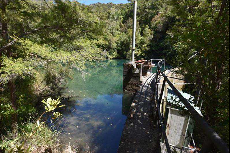
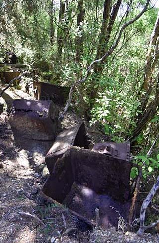
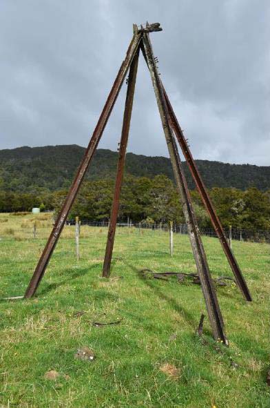
Travelling north from Tākaka, Onekaka is approximately halfway between Tākaka and Collingwood. The Onekaka Ironworks Quarries and Hydro-scheme is up in the hills 1.5 kilometres southwest of the end of Onekaka Ironworks Road, across multiple private properties. The place is not publicly accessible, except with prior permission from private landowners. Through bush, a very steep private road leads up to the hydro-dam, largely following the route of the original access track used by the quarry workers, although now much widened and improved. First encountered are the foundations of the old powerhouse, just uphill from the new power station. All that remains of the old powerhouse are the concrete foundations, containing a reinforced open channel, representing the former penstock entry. Pipework is fixed along the floor at the southwestern edge; a valve is embossed with “J. STONE & CO LTD / DEPTFORD / LONDON S.E.” J. Stone & Co Ltd was a British marine, railway and general engineering company founded in 1831. Along the road, cut sections of iron pipes re-employed as catchpit inlets to channel drainage into culverts, hint at the place’s past. Part-way up, one of the cuttings that branches off to the northwest of the road leads to an approximately 30-metre-long section of intact penstock, lying flat along a wide, cleared bench. The pipes are joined by the rivet-and-hook method. Looking uphill from here, the tower of the new surge chamber is visible above the treetops. The remains of fallen tramway buckets lie strewn amongst the bush. The old surge chamber stands across the road from the new surge chamber. It is signified by a tower of riveted pipes (as opposed to the welded pipes of the new surge chamber), 40 centimetres in diameter, anchored in a concrete base that contains shells and gravel from Onekaka beach. No longer part of the functioning hydro-scheme, sections of disconnected penstock lie alongside the road in the near vicinity. The concrete arch dam is 30 metres across, and over 10 metres high. Its poured-layer construction can be read on its face; the masonry also contains shells and pebbles. At its base, the old scour pipe protrudes; this has been capped and plugged with concrete. Its former valve—removed because its great weight was threatening the pipe’s integrity—lies nearby. The new galvanised steel scour pipe protrudes from slightly higher up in the dam wall, sheltered by an awning. The new penstock outlet is located at the eastern edge of the dam. Above this sits a small operation shed, also modern and accessed by a metal catwalk. Iron rungs leading up from here to the crest of the dam are an original heritage feature. The concrete intake bay sits within the holding pond at the rear of the dam; it is of the same concrete construction and also bears the marks of its formwork. A new automatic stainless steel screen system replaced the original intake screen in the 2003 works. Near the surge chambers a track branches off to the south of the road. This leads through bush uphill to the quarries and workers’ camp, largely following the route of the old track. Workers’ huts are evidenced by artefactual material lying round amongst the scrub, including whisky, lemonade and Worcester sauce bottles, and concrete fireplace bases. Scraps of corrugated iron and metal oven doors are from these huts. A track did previously run between this camp and the dam, but this is now hard to trace. The quarry area was briefly examined, around the vicinity of the upper terminal of the aerial ropeway. The most prominent feature in this area is the concrete foundation that the bullwheel for the cable was mounted on. This large concrete block, approximately 2 metres high with a small gable at its highest end, contains shells and slag in its mix. A small guide wheel (to feed the cable to the bullwheel) is fixed to each side. Behind this the bullwheel would have been mounted horizontally on a recessed platform; the two substantial brackets for its support beam remain but the beam, presumably timber, has gone. The impressive bullwheel, at least 2 metres in diameter, lies in the bush nearby. Young reports that the bullwheel was made in two halves, bolted together; presumably this made transportation easier. Pairs of metal truck wheels connected by an axle (remains of the hand trucks used to load the ore into the ropeway buckets), buckets, hoppers, railway irons and various other bits of machinery are scattered around this area. Archaeologists Steve Bagley (1994) and Amanda Young (2003) reported further remains of the aerial ropeway along its route between the upper terminal and the lower terminus at the ironworks. These included standing towers (timber and iron); suspension, guideline and pulley assemblies; buckets; and parts thereof. None of these were able to be re-located on the current site visit, however while some towers may have collapsed due to the high moisture levels in their bush environment, at least three reportedly still remain. One example of a standing tower is on private farmland below the powerhouse. This consists of four railway irons (embossed ‘OF…1903…COUILLET BELGIUM’), anchored in concrete and propped together in a pyramid. Multiple bolts protrude from each iron, signifying the location of attachments for bracing and mechanisms. Two sets of pulley/guidewheels for relaying cable past the tower, and various timber beams, lie fallen at its base. More sets of the cable relays lie twisted and broken at other former tower sites on this property, but their towers are no longer discernible.
Travelling north from Tākaka, Onekaka is approximately halfway between Tākaka and Collingwood. The Onekaka Ironworks Quarries and Hydro-scheme is up in the hills 1.5 kilometres southwest of the end of Onekaka Ironworks Road, across multiple private properties. The place is not publicly accessible, except with prior permission from private landowners. Through bush, a very steep private road leads up to the hydro-dam, largely following the route of the original access track used by the quarry workers, although now much widened and improved. First encountered are the foundations of the old powerhouse, just uphill from the new power station. All that remains of the old powerhouse are the concrete foundations, containing a reinforced open channel, representing the former penstock entry. Pipework is fixed along the floor at the southwestern edge; a valve is embossed with “J. STONE & CO LTD / DEPTFORD / LONDON S.E.” J. Stone & Co Ltd was a British marine, railway and general engineering company founded in 1831. Along the road, cut sections of iron pipes re-employed as catchpit inlets to channel drainage into culverts, hint at the place’s past. Part-way up, one of the cuttings that branches off to the northwest of the road leads to an approximately 30-metre-long section of intact penstock, lying flat along a wide, cleared bench. The pipes are joined by the rivet-and-hook method. Looking uphill from here, the tower of the new surge chamber is visible above the treetops. The remains of fallen tramway buckets lie strewn amongst the bush. The old surge chamber stands across the road from the new surge chamber. It is signified by a tower of riveted pipes (as opposed to the welded pipes of the new surge chamber), 40 centimetres in diameter, anchored in a concrete base that contains shells and gravel from Onekaka beach. No longer part of the functioning hydro-scheme, sections of disconnected penstock lie alongside the road in the near vicinity. The concrete arch dam is 30 metres across, and over 10 metres high. Its poured-layer construction can be read on its face; the masonry also contains shells and pebbles. At its base, the old scour pipe protrudes; this has been capped and plugged with concrete. Its former valve—removed because its great weight was threatening the pipe’s integrity—lies nearby. The new galvanised steel scour pipe protrudes from slightly higher up in the dam wall, sheltered by an awning. The new penstock outlet is located at the eastern edge of the dam. Above this sits a small operation shed, also modern and accessed by a metal catwalk. Iron rungs leading up from here to the crest of the dam are an original heritage feature. The concrete intake bay sits within the holding pond at the rear of the dam; it is of the same concrete construction and also bears the marks of its formwork. A new automatic stainless steel screen system replaced the original intake screen in the 2003 works. Near the surge chambers a track branches off to the south of the road. This leads through bush uphill to the quarries and workers’ camp, largely following the route of the old track. Workers’ huts are evidenced by artefactual material lying round amongst the scrub, including whisky, lemonade and Worcester sauce bottles, and concrete fireplace bases. Scraps of corrugated iron and metal oven doors are from these huts. A track did previously run between this camp and the dam, but this is now hard to trace. The quarry area was briefly examined, around the vicinity of the upper terminal of the aerial ropeway. The most prominent feature in this area is the concrete foundation that the bullwheel for the cable was mounted on. This large concrete block, approximately 2 metres high with a small gable at its highest end, contains shells and slag in its mix. A small guide wheel (to feed the cable to the bullwheel) is fixed to each side. Behind this the bullwheel would have been mounted horizontally on a recessed platform; the two substantial brackets for its support beam remain but the beam, presumably timber, has gone. The impressive bullwheel, at least 2 metres in diameter, lies in the bush nearby. Young reports that the bullwheel was made in two halves, bolted together; presumably this made transportation easier. Pairs of metal truck wheels connected by an axle (remains of the hand trucks used to load the ore into the ropeway buckets), buckets, hoppers, railway irons and various other bits of machinery are scattered around this area. Archaeologists Steve Bagley (1994) and Amanda Young (2003) reported further remains of the aerial ropeway along its route between the upper terminal and the lower terminus at the ironworks. These included standing towers (timber and iron); suspension, guideline and pulley assemblies; buckets; and parts thereof. None of these were able to be re-located on the current site visit, however while some towers may have collapsed due to the high moisture levels in their bush environment, at least three reportedly still remain. One example of a standing tower is on private farmland below the powerhouse. This consists of four railway irons (embossed ‘OF…1903…COUILLET BELGIUM’), anchored in concrete and propped together in a pyramid. Multiple bolts protrude from each iron, signifying the location of attachments for bracing and mechanisms. Two sets of pulley/guidewheels for relaying cable past the tower, and various timber beams, lie fallen at its base. More sets of the cable relays lie twisted and broken at other former tower sites on this property, but their towers are no longer discernible.
Historical and Associated Iwi / Hapū / Whānau
Public NZAA Number
M25/26
Completion Date
20th October 2021
Report Written By
Blyss Wagstaff
Information Sources
Young, 2002
Amanda Young, Heritage Inventory: The Onekaka Hydro-electricity Scheme, unpublished client report, 30 July 2002
Templeton, 2006
Fleur Templeton, 'Iron and steel', Te Ara - the Encyclopedia of New Zealand, 2006, http://www.TeAra.govt.nz/en/iron-and-steel
Heskett, 1930
J.A. Heskett, ‘Onakaka Iron and Steel works: an important Nelson industry’, Nelson Evening Mail, 4 October 1930, p.14
Stephens, 2008
Joy Stephens, ‘Onekaka Ore’, The Prow, 2008b, URL: http://www.theprow.org.nz/enterprise/onekaka-ore/#.XS_gTWeP6Uk
Newport, 1979
J.N.W. Newport, ‘Some Industries of Golden Bay’, Nelson Historical Society Journal, Vol 3 Issue 5, October 1979, pp.5-26.
Other Information
Please note that entry on the New Zealand Heritage List/Rārangi Kōrero identifies only the heritage values of the property concerned, and should not be construed as advice on the state of the property, or as a comment of its soundness or safety, including in regard to earthquake risk, safety in the event of fire, or insanitary conditions. Archaeological sites are protected by the Heritage New Zealand Pouhere Taonga Act 2014, regardless of whether they are entered on the New Zealand Heritage List/Rārangi Kōrero or not. Archaeological sites include ‘places associated with pre-1900 human activity, where there may be evidence relating to the history of New Zealand’. This List entry report should not be read as a statement on whether or not the archaeological provisions of the Act apply to the property (s) concerned. Please contact your local Heritage New Zealand office for archaeological advice. A fully referenced New Zealand Heritage List/Rārangi Kōrero report is available on request from the Central Office of Heritage New Zealand Pouhere Taonga.
Current Usages
Uses: Civic Facilities
Specific Usage: National park
Uses: Ruin
Specific Usage: Misc Archaeological
Uses: Transport
Specific Usage: Footpath/Path/track
Uses: Utilities
Specific Usage: Power House
Former Usages
General Usage: Cultural Landscape
Specific Usage: Industrial/mining landscape
General Usage: Mining
Specific Usage: Aerial ropeway
General Usage: Mining
Specific Usage: Mining & Mineral Processing - other
General Usage: Mining
Specific Usage: Mining camp/settlement/housing
General Usage: Mining
Specific Usage: Quarry
General Usage: Utilities
Specific Usage: Reservoir/ Dam
Themes
Of Significance to Maori
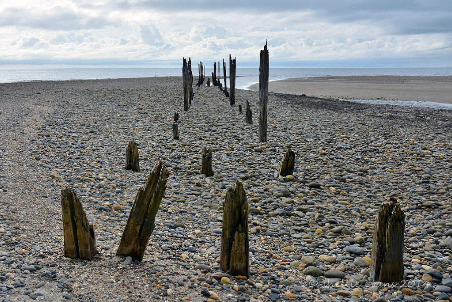
Sign up to hear more
Get the latest heritage news, features and events delivered
straight to your inbox.
