

The area lies near the south end of the valley, which is closely associated with the shapeshifter Horotiu, kaitiaki (guardian) of Te Wai o Horotiu or the Horotiu creek. Māori settlement beside this watercourse included occupation on the site of the current Auckland Town Hall and adjoining Aotea Square. Also in the vicinity was a kāinga for female hawini (attendants) and kaimahi (helpers) who cared for Horotiu. The gully occupied by the present Myers Park formed a taniwha mahinga kai or taniwha feeding/grazing area. In 1840, Ngāti Whātua provided land for Auckland to be created as a colonial city. By the mid-1860s working-class housing developed in the gully, next to the upper end of Queen Street - by this time the city’s main commercial thoroughfare. At the turn of the century, numerous groups expressed concern about the perceived poor condition of such housing and both the moral and physical welfare of its inhabitants - exacerbated by bubonic plague scares and other fears. Renewed prosperity in Queen Street from the mid-1890s likely also stimulated middle-class desires for beautification.
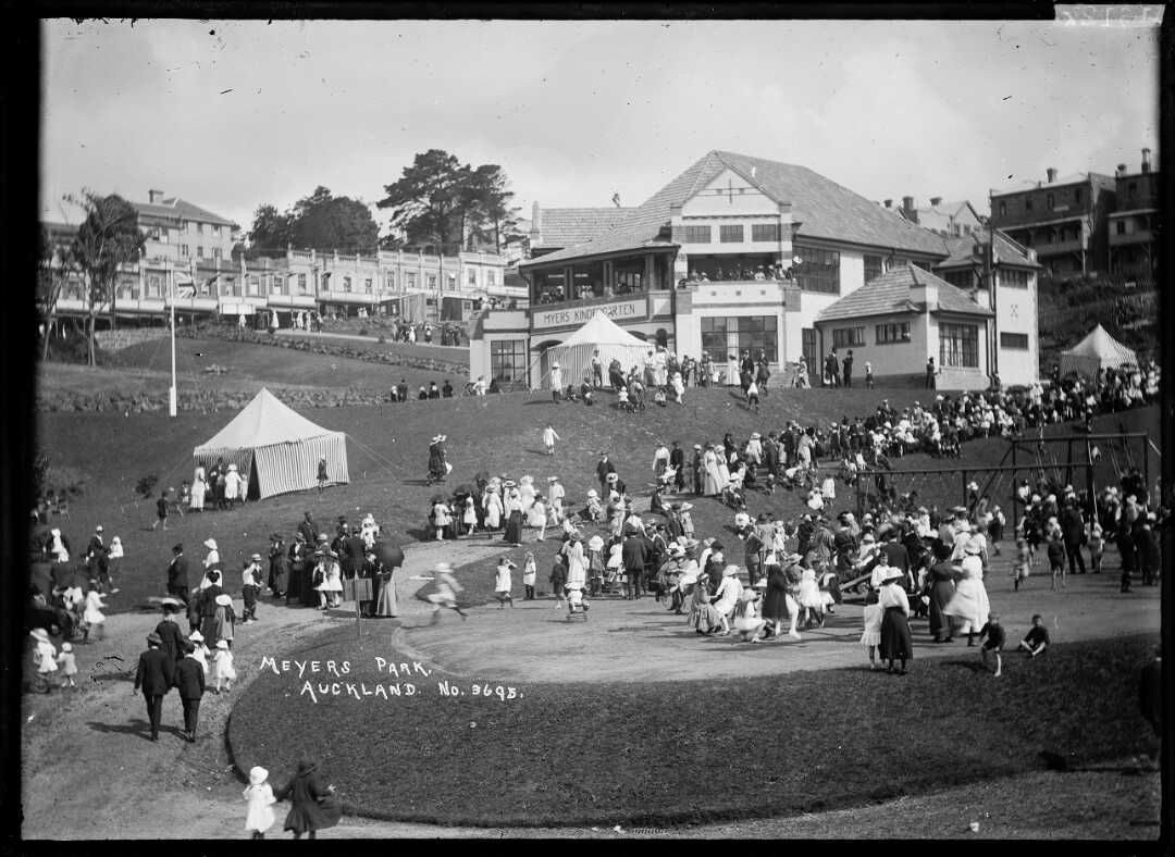
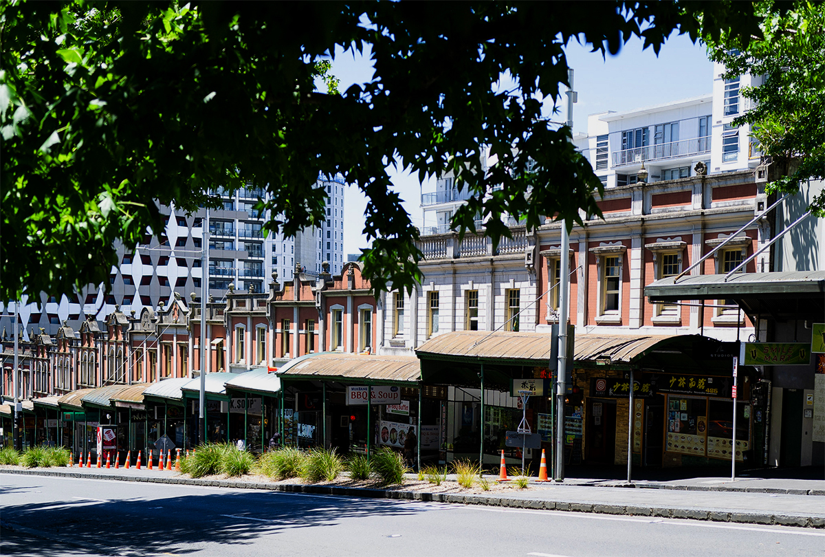
In 1908-12, a handsome, brick terrace of shops containing first floor dwellings was erected on the Queen Street frontage, tenanted mostly by single-person businesses at low rents. This development was commissioned by leaseholder, Neville Newcombe, on land owned by Methodist authorities - themselves active in social movements intended to alleviate poverty. The year after its completion, Liberal MP and prominent member of Auckland’s Jewish community, Arthur Myers (1867-1926) donated funds to the City Council to acquire land in the gully opposite the shops for a children’s park, presaging further beautification. An early proponent of Town Planning laws in New Zealand, Myers was influenced by the ideas of his American sister-in-law Martha Washington Myers (1867-1945), who promoted the importance of parks as healthy settings for children’s activities, notably in association with free kindergartens. Myers’ donation occurred in the context of simmering class tension in Auckland and elsewhere, which came to a head in the 1913 General Strike.
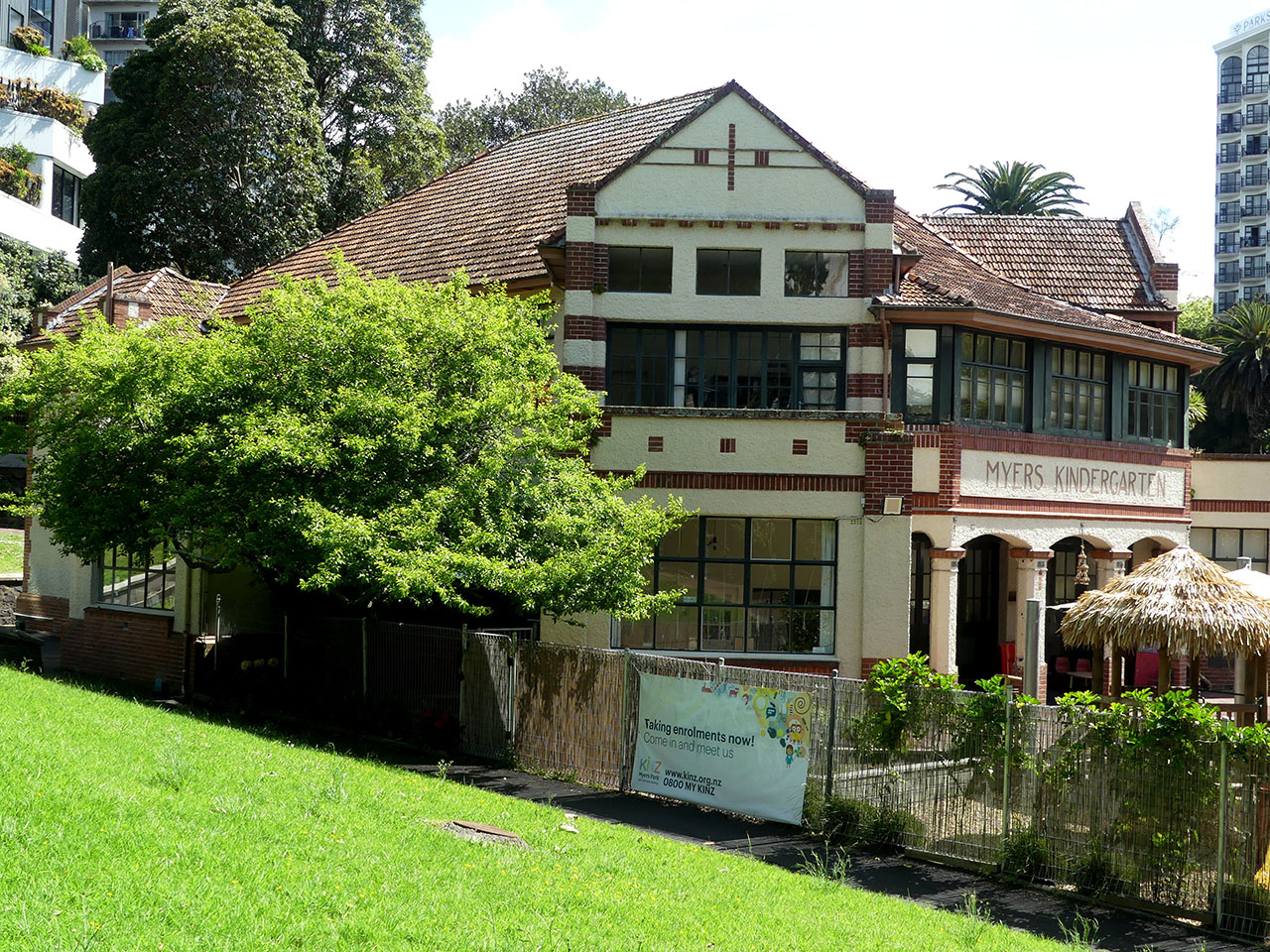
The proposed park was framed by its proponents as an experiment that would help establish the scientific basis of town planning to improve the health and lives of community members, particularly local, working-class mothers and infants. After nearly all pre-existing houses were removed from the site, the park opened in January 1915 with a new playground and wading pool. Myers also funded construction of Myers Kindergarten, a large two-storey brick building of Arts and Crafts design (1916) housing both a free kindergarten and a school for children with special learning needs. In addition to further landscaping, formal park gates at the Queen Street entrance were erected.
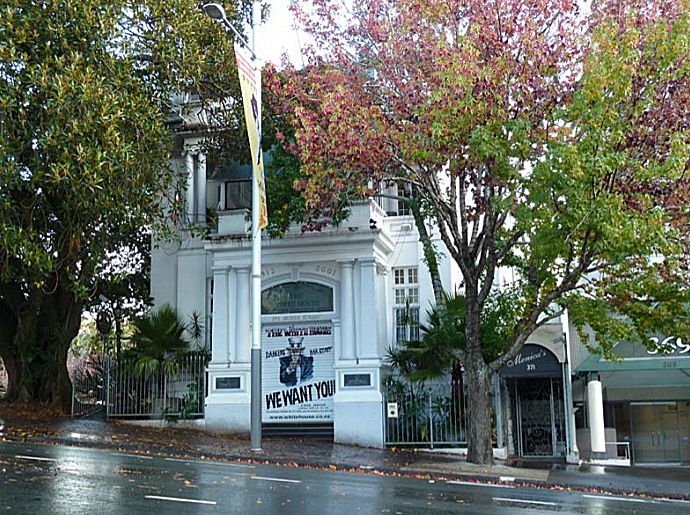
The area’s transformation continued with construction of a Young Women’s Christian Association or YWCA building (now demolished) on the south side of the Queen Street entrance in 1917, intended to serve women working in the vicinity. By the inter-war period, the 1908-12 shops were tenanted by a high proportion of women’s businesses involved in fabric and textile work. The Theosophical Society, a world organisation for the promotion of brotherhood and encouragement of the study of religion, philosophy and science, also built a visually striking hall of neo-Classical design to the north of the entrance in 1922-3.
From its inception, the park was a meeting place for people other than those for whom it was formally designed. By the 1960s it had become the site of many student protests, with regular gatherings forming a precursor to Jumping Sundays at Albert Park. It was also part of sex workers’ beats for many decades, including for members of the LGBTQIA+ community. In 2000, the Theosophical Society Hall was converted into an adult entertainment club.
Retaining its operational kindergarten and row of shops, the park and its associated area continues to reflect notable aspects of its early 1900s purpose, as well as serving alternative needs of its surrounding communities.


List Entry Information
Status
Listed
List Entry Status
Historic Area
Access
Able to Visit
List Number
7008
Date Entered
16th December 1994
Date of Effect
16th December 1994
City/District Council
Auckland Council
Region
Auckland Council
Extent of List Entry
Extent includes the land known as Pt Allot 14 Sec 29 Town of Auckland (RT NA352/144), Pt Allot 14 Sec 29 City of Auckland (RT NA1391/28), Pt Lot 15 DP 2816 (RT NA337/101), Lot 16 and Pt Lot 15 DP 2816 (RT NA113/265), Lot 2 DP 9036 (RT NA302/191), Pt Allots 15 16 Sec 29 Town of Auckland (RT NA751/7) and Lot 1 DP 173799 (RT NA106C/803), and part of the land known as Lot 4 DP 322571 (RT 90052) and Legal Road, North Auckland Land District, and the buildings and structures known as Myers Park, Myers Kindergarten, Theosophical Society Hall (HPB Lodge) (Former) and Terrace of shops thereon. Extent includes park gates and seats, Phoenix palms (x2), Oaks (x3), Moreton Bay Fig, and grove of mature trees west of Theosophical Society Hall (HPB Lodge) (Former) including Pūriri (x5), Laurel (x2) and unspecified trees (x2).
Legal description
Pt Allot 14 Sec 29 Town of Auckland (RT NA352/144), Pt Allot 14 Sec 29 City of Auckland (RT NA1391/28), Pt Lot 15 DP 2816 (RT NA337/101), Lot 16 and Pt Lot 15 DP 2816 (RT NA113/265), Lot 2 DP 9036 (RT NA302/191), Pt Allots 15 16 Sec 29 Town of Auckland (RT NA751/7), Lot 1 DP 173799 (RT NA106C/803), Lot 4 DP 322571 (RT 90052) and Legal Road, North Auckland Land District
Why is this place significant?
Cultural Significance
Cultural/Social: This area underwent considerable change around the turn of the century. A slum housing area was transformed into an attractive recreational space with community facilities reflecting the community's expectations of better urban conditions.
Historic Significance
Historical Significance or Value This area is particularly significant in terms of the redevelopment of a once slum area into a commercial/community centre. The creation of Myers Park together with community facilities such as the Kindergarten indicate Auckland's growing interest in the importance of town planning in the early decades of the twentieth Century. The redevelopment of this area was made possible with the improvements in transportation.
Physical Significance
Architectural: The buildings grouped around the formal entrance to Myers Park represent the diversity of architectural styles common during the first quarter of the century. The terrace shops with a range of features incorporated into their design illustrate the eclectic nature of Edwardian architecture. The Kindergarten is designed in the Arts & Crafts style, popular at the time, and in contrast, the Theosophical Society Hall follows a more traditional neo-Classical design. Aesthetic: The Myers Park area has aesthetic appeal and acts as a mediating space between the parkland and the urban nature of Queen Street. The area is enhanced by mature trees and a group of historic buildings ranging in architectural styles.
Construction Professional
Name
May, T W
Type
Architect
Biography
An Auckland architect responsible for a number of residential and commercial buildings around the city including three 7 storey concrete warehouses for Arthur Yates and Co. Designed Shop/Dwellings for the Terrace Shops, 456-486 Queen Street, Auckland in 1909.
Name
Craig Brothers
Type
Builder
Biography
No biography is currently available for this construction professional
Name
Robinson, Henry.F
Type
Architect
Biography
No biography is currently available for this construction professional
Name
Chilwell and Trevithick
Type
Architectural Partnership
Biography
No biography is currently available for this construction professional
Name
Wiseman, Alexander
Type
Architect
Biography
Alexander Wiseman (1865-1915) - Articled to Edward Bartley 1881-85. Began practising as an architect in 1904. The Auckland Ferry building (classified 'B') is his best known work and shows he was an architect of considerable ability.
Name
Pearson, Thomas Edward
Type
Designer
Biography
Thomas Edward Pearson (circa 1857-1930). English born Pearson was the son of a nurseryman. After various positions around the world, in 1901 he was employed with the newly created Tourist and Health Department and by 1907 was responsible for the development of reserves in Rotorua, Te Aroha, Hamner and Queenstown, until his appointment as Park Superintendant for Auckland City in 1908. He was also responsible for the design of the fernery for the Christchurch Exhibition in Hagley Park in 1906/1907 and the grounds layout for the Auckland Exhibition in the Domain in 1913/14. Pearson was a Fellow of the Royal Horticultural Society.
Construction Details
Start Year
1908
Finish Year
1912
Type
Original Construction
Description
Terrace of Shops
Start Year
1916
Type
Original Construction
Description
Park and playground
Start Year
1916
Type
Original Construction
Description
Myers Kindergarten and Queen Street gates
Type
Original Construction
Description
Public Toilet
Period
Pre-1920
Start Year
1922
Finish Year
1923
Type
Original Construction
Description
Theosophical Society Hall
DESCRIPTION OF BOUNDARY: The buildings are grouped around approximately an acre of Myers Park, an extensive reserve in the gully confined by Queen St, Greys Avenue, Poynton Terrace and Mayor Drive. LIST OF ITEMS: Terraced Shops, Myers Kindergarten, Theosophical Society Hall, seats at the entrance to Myers Park. Trees-2 Phoenix Palms, 1 Morten Bay Fig, 3 Oaks, Grove of mature trees (includes 5 Puriri, 2 Laurel, 2 trees of unknown species) west of Theosophical Hall but within Myers Park. STRUCTURES: Terrace Shops, 456-86 Queen St - Category I Architect(s): T.W. Hay, Alex Wiseman (built at different stages) 1908-12 Brick construction; two storey Features: series of arched verandahs along the street frontage give the impression of one continuous building, individual shops with subtle variations in design Kindergarten, 379 Queen St - Category II Architect: Chilworth & Trevithick Free English Renaissance, 1915 Brick construction; two storey Features: rough cast brick, pointed brick finish, Marseilles tile roof Theosophical Society Hall, 371 Queen St - Category II Architect: H.F. Robinson Neo Classical, 1922 Concrete construction; three storey Features: elaborate Neo Classical facade Park gates and seats: Large mature trees within park: 2 Phoenix Palms 1 Morten Bay Fig 3 Oaks Grove of mature trees (includes 5 Puriri, 2 Laurel, 2 trees of unknown species
DESCRIPTION OF BOUNDARY: The buildings are grouped around approximately an acre of Myers Park, an extensive reserve in the gully confined by Queen St, Greys Avenue, Poynton Terrace and Mayor Drive. LIST OF ITEMS: Terraced Shops, Myers Kindergarten, Theosophical Society Hall, seats at the entrance to Myers Park. Trees-2 Phoenix Palms, 1 Morten Bay Fig, 3 Oaks, Grove of mature trees (includes 5 Puriri, 2 Laurel, 2 trees of unknown species) west of Theosophical Hall but within Myers Park. STRUCTURES: Terrace Shops, 456-86 Queen St - Category I Architect(s): T.W. Hay, Alex Wiseman (built at different stages) 1908-12 Brick construction; two storey Features: series of arched verandahs along the street frontage give the impression of one continuous building, individual shops with subtle variations in design Kindergarten, 379 Queen St - Category II Architect: Chilworth & Trevithick Free English Renaissance, 1915 Brick construction; two storey Features: rough cast brick, pointed brick finish, Marseilles tile roof Theosophical Society Hall, 371 Queen St - Category II Architect: H.F. Robinson Neo Classical, 1922 Concrete construction; three storey Features: elaborate Neo Classical facade Park gates and seats: Large mature trees within park: 2 Phoenix Palms 1 Morten Bay Fig 3 Oaks Grove of mature trees (includes 5 Puriri, 2 Laurel, 2 trees of unknown species
Historical and Associated Iwi / Hapū / Whānau
Completion Date
21st June 2023
Report Written By
Alexandra Foster and Martin Jones
Information Sources
Auckland Star
Auckland Star
New Zealand Herald
New Zealand Herald, ‘Historic Hut is Preserved’, 25 March 1961
Matthews and Matthews, 1998
Matthews, Jane and Antony, ‘Myers Park Kindergarten, 381 Queen Street, Auckland: Conservation Plan’, [Auckland], 1998
Cairncross and Nelson, 1996
Cairncross, Craig and Thyra Rachel Nelson, ‘Conservation Plan: The Queen Street Shops’, [Auckland], 1996
Cusins-Lewer and Gatley, 2002
Cusins-Lewer, Anéne and Julia Gatley, The ‘Myers Park Experiment’ (1913–1916) and its Legacy in Auckland’, Fabrications, 12:1, 2002, pp.59-80
Foster, 2012
Foster, Russell, ‘Myers Park Improvements: Archaeological Assessment’, Oct 2012, Auckland
Stone, 1996
Stone, R.C.J., 'Myers, Arthur Mielziner', Dictionary of New Zealand Biography, first published in 1996, Te Ara - the Encyclopedia of New Zealand
Other Information
A fully referenced copy of the upgrade report is available on request from the Northern Regional Office of Heritage New Zealand Pouhere Taonga This historic place was registered under the Historic Places Act 1993. This report includes text from the original Proposal for Registration considered by the NZHPT Board at the time of registration. Please note that entry on the New Zealand Heritage List/Rārangi Kōrero identifies only the heritage values of the property concerned, and should not be construed as advice on the state of the property, or as a comment of its soundness or safety, including in regard to earthquake risk, safety in the event of fire, or insanitary conditions.
Current Usages
Uses: Civic Facilities
Specific Usage: Park
Uses: Education
Specific Usage: Pre-school education
Uses: Trade
Specific Usage: Brothel
Uses: Trade
Specific Usage: Shop
Uses: Trade
Specific Usage: Shopping/retail complex
Former Usages
General Usage: Civic Facilities
Specific Usage: Club rooms/building
General Usage: Civic Facilities
Specific Usage: Hall, Community
General Usage: Civic Facilities
Specific Usage: Tree/tree groups
General Usage: Religion
Specific Usage: Meeting House
Themes
Rainbow List
Sign up to hear more
Get the latest heritage news, features and events delivered
straight to your inbox.
