

The land was owned from 1839-40 by John Vittoria Cowell, trader of Kawhia and Waipa districts, and his wife Keke Tumohe (Ngati Apakura) and the house is believed by their descendants to have been built by them as a residence. It is also believed to have operated as a bush hotel and residence until the Waikato War of 1863-64. The Cowells had a trading store on the east bank of the Waipa River, a small house (or another store) on the western bank and another larger house west of the Waipa River. A Maori-owned flour mill was being built nearby in 1853 (completion date not established). The house is situated at the junction of tracks from the Kawhia and Raglan areas in the west with north-south tracks, as well as being on the main route, the Waipa River.
Because of Cowell's sympathies with Maori concerns, his property was confiscated by the colonial government under the New Zealand Settlements Act 1863. A portion was granted to Charles Allan Edenborough as his military allotment for service as quartermaster in the Second Regiment of Waikato Militia. Edenborough sold the house and property to Isaac Hodgson in 1874. Edenborough became a shipping merchant in Auckland as partner in the firm of Donald and Edenborough, serving the South Pacific islands.
Hodgson and his wife Margaret had a farm of at least 1500 acres (607 hectares) on which they grew a variety of crops as well as grazing cattle, sheep and work horses. It is probable that the older extant outbuildings relate to their occupancy. Hodgson became a prominent local identity, serving on various committees such as the Agricultural and Pastoral Association, the Pirongia Roads Board, Pirongia Highway Board, Harapepe School Committee, and the County Council. He was often the chairman of such bodies, and was director of the Farmers Co-operative Association in 1885. His family owned the property until 1953. The current owners Les and Heather Garrett have occupied the house for over 40 years and are also prominent in local organisations.
The house was prominent in the affairs of the district, at various times serving as a school, a venue for funerals, weddings and social gatherings for the community, and the grounds being used for picnics by various groups including schools and Girl Guides.
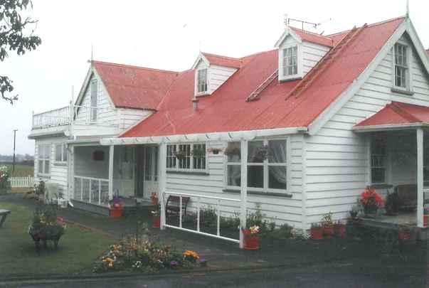
The house may have been a prefabricated house, or its design derived from a pattern book. It was constructed in at least two major phases, the original portion being covered with a shingle roof (now covered with iron sheeting). The house is in good condition with some modifications, most of which are sympathetic to the original style. The outbuildings are in poor to good condition. One may date to the late 19th century and two to the late 19th - early 20th centuries. Two wells are known to exist.
List Entry Information
Status
Listed
List Entry Status
Historic Place Category 2
Access
Private/No Public Access
List Number
739
Date Entered
15th February 2008
Date of Effect
15th February 2008
City/District Council
Waipā District
Region
Waikato Region
Extent of List Entry
The registration includes part of the land in RT SA45C/744 (as shown on the 'Extent of Registration' map in Appendix 3) and the buildings, structures and their fittings and fixtures thereon.
Legal description
Allotment 83 Parish of Pirongia (part of RT SA45C/744), South Auckland Land District
Location Description
Corner Rosborough Road and Hodgson Road. Allotment 83 is also known as 129 Rosborough Road but owners use 144 Hodgson Road (which refers to Allotment 82) as their address. Homewood is near the settlements of Te Rore and Te Pahu and Ngahinapouri.
Why is this place significant?
Cultural Significance
CULTURAL SIGNIFICANCE OR VALUE The property is associated with the first Maori King Potatau Te Wherowhero, who is believed to have given gifts of pear trees to the Cowells; the whanau of Keke Tumohe (aka Mata Cowell) whanau (Ngati Koroki, Ngati Apakura) hold the place in respect. A tapu was placed on the house and road after some of the trees attributed to Te Wherowhero were cut down prior to the purchase by the current owners. (The tapu has since been lifted.) Keke Tumohe was of high status, being the daughter of Tumohe Taraunahi, a chief of Te Pakuru pa, and his wife Pinenga, and half-sister of the Rangiaowhia chief Wiremu Toe Toe Tumohe. When she died in 1896 she was believed to be the last of the Ngati Waikohika sub-tribe as well as the oldest of Ngati Apakura. SOCIAL SIGNIFICANCE OR VALUE The house has strong significance for the wider community, having been used for weddings, funerals and social occasions such as picnics. The relationship of the house to the Cowell family is not challenged by community and it is valued for its age.
Historic Significance
Historical Significance or Value The property is associated with prominent Waikato-Waipa trader John Vittoria Cowell and his wife Mata and therefore the place represents the era of European traders who settled amongst local iwi in the 1830s-40s. It is associated with Pakeha-Maori and inter-racial marriage; relations with missionaries and government over Maori land and lack of support for those favourable to Maori land issues; association with the land wars in the Waikato, with the confiscation of the land and subsequent allotment to a Waikato Militia settler. The house is known to have belonged to Charles Edenborough, quartermaster for the Waikato Militia and subsequently an Auckland merchant; and with Isaac Hodgson farmer and local body politician. Part of the house was used as a schoolroom prior to the Te Rore School being built.
Physical Significance
ARCHAEOLOGICAL SIGNIFICANCE OR VALUE The property was occupied pre 1900 and is, therefore, an archaeological site under the provisions of the Historic Places Act. Homewood can be considered to possess significant archaeological values. It is located on land that was used pre 1900 and has been occupied for at least 150 years, and for which the evidence of this past human activity still exists in the form of middens, old wells, and other associated structures. Homewood offers the opportunity through archaeological techniques to understand nineteenth century occupation of the Waikato, and the associated changing patterns of land use brought about by the arrival of colonial settlement. TECHNOLOGICAL SIGNIFICANCE OR VALUE The house may have evidence for early kit set (prefabricated) or pattern book houses imported to New Zealand and colonial structural techniques. The house retains a form of heat insulation with sawdust in the wall cavities and an area of original wooden shingles remains underneath the corrugated steel roof. Much of the original joinery retains hand-forged nails.
Why is this place Category 1 / Category 2?
Detail Of Assessed Criteria
(a) The extent to which the place reflects important or representative aspects of New Zealand history: Homewood is closely associated with the Waikato Wars, the confiscation of land by the government, military land allocations of confiscated Waikato land and the subsequent opening up of the Waikato and Waipa districts for European settlements and farming methods. The place may represent an early period of Maori-European relationships and the beginnings of the trading of European goods to Maori and distribution of Maori produce to the wider markets. The place represents the changing lifestyles of colonial settlers who were able to improve their living conditions, financial status and social status in the new colony. The property is associated with a high-ranking Maori woman, Keke Tumohe, who experienced several changes of lifestyle from traditional Maori to being the wife of a European engaged in commercial businesses as well as farming; suffering displacement and exile and the confiscation of her land during the Waikato wars of the 1860s and the subsequent need to appeal for recognition of her status and previous land interests in the compensation courts. (b) The association of the place with events, persons, or ideas of importance in New Zealand history: The property is associated with the Cowell family, traders in Kawhia from c.1831, who had major roles in the introduction of European goods and customs into Tainui society. John Cowell, father or son, played a major role in significant events such as the involvement of the Elizabeth in intertribal warfare in 1830; both John Cowells adopted the Pakeha-Maori lifestyle adopted by several European men during the initial years of Maori and Pakeha interaction; both were involved in inter-racial marriage and in land acquisition by gift from tangata whenua prior to the Treaty of Waitangi. John Vittoria Cowell is one of the first Pakeha to live in inland Waikato/Waipa; his stepmother Mary Ann Cowell was the first white woman to live at Kawhia. John V. Cowell operated a trading post and a flour mill near the property and a hotel on or near the property, prior to the 1863-64 war and his life illustrates the role of Pakeha-Maori in the Waikato wars and subsequent land disputes. The place is associated with Charles Edenborough, owner from 1867 to 1874. Edenborough was quartermaster to the Second Regiment of Waikato Militia who subsequently became a prominent merchant and a South Pacific Islands shipping trader in partnership with A.B. Donald in Auckland. The place is associated with Isaac Hodgson, a farmer who became a prominent member of the local community serving on highway boards, local councils and committees and thereby helped in the development of infrastructure and local body administration. Hodgson played a part in the trout fishing industry by constructing a dam on a local waterway, Stony Creek, to receive trout in 1886. (c) The potential of the place to provide knowledge of New Zealand history: The place has a strong potential to provide knowledge of aspects of New Zealand history, in particular the changing relationships between Maori and Pakeha in the Waikato-Waipa districts, the intensification of European crops and methods of farming, the role of local farmers in local politics and community affairs. The house has strong potential to provide knowledge of early colonial building techniques, expansion of buildings as need arises and the changing attitudes towards conservation and preservation of heritage structures. The house has been occupied for c.130 years by European families and perhaps previously by a Maori-Pakeha family; reputedly as a 'bush hostel' or refreshment place for travellers; as a school; for farming activities with associated outhouses including cowshed, woolshed, pump shed, windmills, wells and possibly a bread oven; evidence of former domestic activities, buildings, gardens and midden associated with all periods of use. Subsurface evidence retrieved through archaeological techniques may provide information about colonial settlement of the Waikato and changing patterns of land use and the use of various extant and previous structures and occupations. (d) The importance of the place to tangata whenua: The place is of importance to tangata whenua as it is known to have been visited by Te Wherowhero when he gifted two pear trees which were planted by the Cowells. The cutting down of these trees in the 1950s led to a tapu being placed on the property, showing the strength of the association with Te Wherowhero. J.V. Cowell's wife Keke and his second stepmother Rewa (Ngati Hikairo) were both Tainui with close links to Potatau Te Wherowhero, the first Maori King. Their descendants strongly associate with the place. A large puriri on the property was reputedly used for burials and/or tangi by local Maori in the 19th century (or earlier). (e)The community association with, or public esteem for the place The community association with, or public esteem for the place is high. Many local and national groups and individuals have visited the property for at least 130 years. The property continues to be used for school gatherings, Girl Guides' activities, vintage motorcycle enthusiasts' gatherings and by other community groups as a focal point for activities. (g)The technical accomplishment or value, or design of the place: The structure of the house retains mid-late 19th century construction techniques, mortise joints, hand-forged nails, wooden walls, floor and shingle roofing, built at a time when materials and expertise would have to be brought in from outside the district. (i) The importance of identifying historic places known to date from early periods of New Zealand settlement: Homewood itself may date from c.1841, or from c.1853, or from the late 1860s. The importance of a house from such early periods of the Waikato's European history is very high as such examples are rare. The property retains several features and outbuildings associated with a rural homestead of the late 19th century. Category: Category II From verified research to date, Homewood is recommended for Category II status as it is a rare example in the Waikato of an early farm homestead dating from at least the late 1860s-1870 in very good and near-original condition. It may date from the early 1840s and been used at some time as a bush hotel as well as a residence, but this has not been verified; it is on the land owned by the proprietor of such a bush hotel. It is in its original setting of trees planted over 100 years ago and retains structures and outbuildings associated with farming activities. The property is known to have been associated with several important people of local, regional and national importance, both Maori and Pakeha. Its location on the junction of early tracks linking the Raglan-Kawhia-Aotea areas to the Waipa district, and adjacent to the Waipa River, which served as the major waterway from Ngaruawahia to the south, is fundamental to its history. It represents aspects of the Waikato Wars such as prejudice against Pakeha-Maori, confiscation and allotment of land to colonial militiamen. Further research verifying its age as pre-1864, the occupation of the house by the Pakeha-Maori trader John Vittoria Cowell and his wife Mata [Keke] and its use as a bush hotel would merit the place being considered for Category I status as a unique remnant of an 1840s and 1850s Waikato accommodation house and residence. Archives that may be useful include: the travel diaries of Hochstetter, Hadfield and Dieffenbach; military records (including paintings) related to the occupation of Te Rore and the establishment of Harapepe redoubt; and survey records for land partition and for roads.
Construction Details
Start Year
1848
startYearCirca
Type
Original Construction
Description
Construction of northwest part of the house as small cottage
Type
Modification
Description
[1853?] house extended along existing gable line?; southern wing built with two north-south ridges
Period
pre-1857
Type
Modification
Description
Shingle roof covered with corrugated iron
Period
pre-1881
Start Year
1870
startYearCirca
Finish Year
1910
finishYearCirca
Type
Modification
Description
Construction of outbuildings.
Start Year
1925
Type
Modification
Description
Electricity installed; water closet toilet in the wash-house.
Type
Modification
Description
Additional window installed. Western (back) verandah partly glazed in and canvas awning installed
Period
pre-1945
Start Year
1945
Type
Modification
Description
Bottom half of stairs removed and lower landing boarded up. Semi en-suite installed in lounge to become bedroom. Dormer windows removed and gaps covered with iron.
Start Year
1953
startYearCirca
Finish Year
1960
finishYearCirca
Type
Modification
Description
House re-piled. Bathroom and kitchen renovated; toilet installed; coal range replaced with space heater. Internal walls in scullery, kitchen, two bedrooms altered. Upper storey boarded up.
Start Year
1953
startYearCirca
Finish Year
1960
finishYearCirca
Type
Modification
Description
Wall lights added; new wiring in several sections of house. En-suite removed from front lounge, fireplace modernised, elaborate kauri mantelpiece and over-mantel replaced with plainer rimu mantelpiece.
Start Year
1953
startYearCirca
Finish Year
1960
finishYearCirca
Type
Modification
Description
Skirting boards in back section replaced with rimu skirting boards. Back (west) verandah demolished, walls enclosed and new windows installed.
Start Year
1967
Type
Other
Description
Fire in kitchen; minor repairs needed.
Start Year
1968
Type
Other
Description
Wahini storm damaged part of roof, barge board and a finial; trees up-rooted; severe damage to out-buildings
Start Year
1976
Type
Addition
Description
Swimming pool installed with fire-fighting system.
Start Year
1977
Type
Modification
Description
Dormer windows reconstructed and installed Stairs reconstructed; upstairs re-floored; deck (balcony) built over the bathroom and door installed. House redecorated including adding plasterboard to sarking.
Start Year
1993
Type
Modification
Description
Verandahs over bay window and front door restored; concrete steps replaced with wooden structures. Kitchen and laundry renovated; French doors from kitchen.
Start Year
2001
Type
Other
Description
Gig shed/car shed collapsed; new shed built.
Start Year
2002
Type
Other
Description
Westernmost of pair of oaks was felled for safety reasons.
Start Year
2005
Finish Year
2006
Type
Modification
Description
Windows that were installed in 1977 rebuilt. Pergola built over kitchen door exit.
Construction Materials
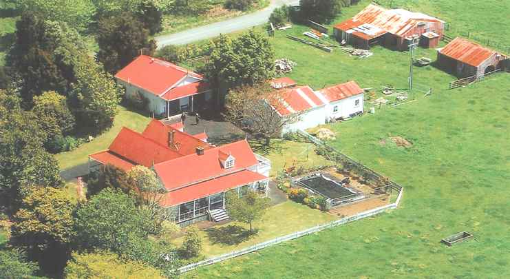
The main building is a two-storeyed timber-framed, wooden weatherboard house with corrugated iron and steel roofs, verandahs and dormer windows. It was erected in two, possibly three, stages. It sits on concrete piles, replacements for the original wooden ones. The outbuildings are single-storey simple buildings of either corrugated iron or wooden weatherboard, with corrugated iron roofs and floors of earth, concrete or timber planking.
Construction Details
Start Year
1848
startYearCirca
Type
Original Construction
Description
Construction of northwest part of the house as small cottage
Type
Modification
Description
[1853?] house extended along existing gable line?; southern wing built with two north-south ridges
Period
pre-1857
Type
Modification
Description
Shingle roof covered with corrugated iron
Period
pre-1881
Start Year
1870
startYearCirca
Finish Year
1910
finishYearCirca
Type
Modification
Description
Construction of outbuildings.
Start Year
1925
Type
Modification
Description
Electricity installed; water closet toilet in the wash-house.
Type
Modification
Description
Additional window installed. Western (back) verandah partly glazed in and canvas awning installed
Period
pre-1945
Start Year
1945
Type
Modification
Description
Bottom half of stairs removed and lower landing boarded up. Semi en-suite installed in lounge to become bedroom. Dormer windows removed and gaps covered with iron.
Start Year
1953
startYearCirca
Finish Year
1960
finishYearCirca
Type
Modification
Description
House re-piled. Bathroom and kitchen renovated; toilet installed; coal range replaced with space heater. Internal walls in scullery, kitchen, two bedrooms altered. Upper storey boarded up.
Start Year
1953
startYearCirca
Finish Year
1960
finishYearCirca
Type
Modification
Description
Wall lights added; new wiring in several sections of house. En-suite removed from front lounge, fireplace modernised, elaborate kauri mantelpiece and over-mantel replaced with plainer rimu mantelpiece.
Start Year
1953
startYearCirca
Finish Year
1960
finishYearCirca
Type
Modification
Description
Skirting boards in back section replaced with rimu skirting boards. Back (west) verandah demolished, walls enclosed and new windows installed.
Start Year
1967
Type
Other
Description
Fire in kitchen; minor repairs needed.
Start Year
1968
Type
Other
Description
Wahini storm damaged part of roof, barge board and a finial; trees up-rooted; severe damage to out-buildings
Start Year
1976
Type
Addition
Description
Swimming pool installed with fire-fighting system.
Start Year
1977
Type
Modification
Description
Dormer windows reconstructed and installed Stairs reconstructed; upstairs re-floored; deck (balcony) built over the bathroom and door installed. House redecorated including adding plasterboard to sarking.
Start Year
1993
Type
Modification
Description
Verandahs over bay window and front door restored; concrete steps replaced with wooden structures. Kitchen and laundry renovated; French doors from kitchen.
Start Year
2001
Type
Other
Description
Gig shed/car shed collapsed; new shed built.
Start Year
2002
Type
Other
Description
Westernmost of pair of oaks was felled for safety reasons.
Start Year
2005
Finish Year
2006
Type
Modification
Description
Windows that were installed in 1977 rebuilt. Pergola built over kitchen door exit.
Construction Materials
The main building is a two-storeyed timber-framed, wooden weatherboard house with corrugated iron and steel roofs, verandahs and dormer windows. It was erected in two, possibly three, stages. It sits on concrete piles, replacements for the original wooden ones. The outbuildings are single-storey simple buildings of either corrugated iron or wooden weatherboard, with corrugated iron roofs and floors of earth, concrete or timber planking.
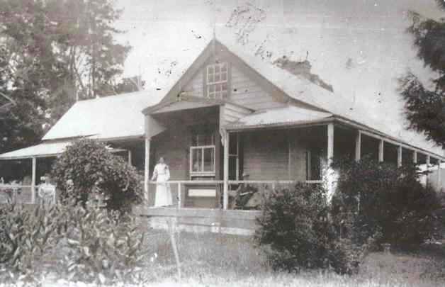
The early history of 'Homewood' and its date of construction are unclear. Local and family tradition states that the house and the property extending down to the Waipa River on both sides of Hodgson Road, plus some land on the east side of the River, was owned from 1840 by John Vittoria Cowell and his wife Keke Tumohe (aka Martha Cowell aka Mata Kaora, aka Martha Risdon). The imputed association of the house to the Cowell family is not challenged by the community and there is no known contrary information. John Vittoria Cowell (1813 -1880) arrived in New Zealand on 13 February 1822 as a young boy with his father John, stepmother Mary Ann Risdon Cowell (aka Martha; nee Howe) and Reverend John Butler of the Church Missionary Society (CMS). John senior was one of Samuel Marsden's lay missionaries and a twine-spinner. In the Roll of Early Settlers and descendants in the Auckland Province John Vittoria Cowell's first place of residence is recorded as Kororareka in 1823, by which time his father had dissolved his connection with the CMS. The family was back in Sydney by February 1824 and still there in 1828. A 'Mr. Cowell' was involved in the Elizabeth incident in 1830, travelling as supercargo (trading master) and interpreter on its voyage from Sydney to Kapiti and thence with Te Rauparaha and Ngati Toa to Akaroa Harbour where several locals were killed and the chief Tamaiharanui, his wife and daughter were captured and killed aboard the vessel, apparently with the connivance of the Pakeha on board. However, as it could not be established which Cowell had been involved, father or son, 'Mr Cowell' was acquitted in the subsequent trial. Decades later it was reported that John V. Cowell used to boast, when drunk, of his exploits in the Elizabeth affair to his guests at his Te Rore hotel. However, another report states that Cowell bitterly regretted his involvement. Family opinion is that involvement with the affair was more in character for the son, i.e. J.V., and the government held the same view when denying him compensation for land confiscated in 1864. John V. Cowell was established at Kawhia as a trader by late 1830-31. In 1832 he and Edward Lee established a trading post at the mouth of the Awaroa River, at the eastern end of the Kawhia Harbour on 5250 acres (2125 hectares) they had purchased. His father also settled at Kawhia in c.1831; having left Marsden's service he became a trader with a successful business based at Kawhia. John senior's wife Mary Ann is believed to have been the first European woman at Kawhia. Mary Ann died in March 1832. John senior married again, to Rewa, Ngati Hikairo, but he was widowed for the third time in 1838 and then cared for by Tawariki, who was possibly a common law wife, until his death in October 1839. In recognition of John Cowell's mana, soon after he was buried 'the chiefs called a great convocation to confer some suitable gift upon his son, and those chiefs present unanimously agreed' to gift John Vittoria Cowell 40,000 acres (over 16100 hectares) 'on the banks of the Waipa river about 40 miles [64 km] from Kawhia'. It seems that soon after this Cowell shifted his trading station inland to the Te Pahu-Te Rore area to the land now occupied by Homewood. The area of Cowell's newly acquired property on the Waipa River had been heavily populated and exploited by Maori who utilised the Waipa River as an easy accessway into the interior and its fertile soils, copious natural resources of food and technological materials. There are nine recorded pa sites in the immediate Te Pahu-Te Rore area, plus artefact findspots and undefended terraces and storage pits. A large puriri on the property was reputedly used for burials and/or tangi by local Maori. The number of Maori in the area encouraged missionaries and traders to establish posts and as the growing of wheat and other European crops flourished the Waipa became a prosperous district. In the 1840s-50s the Waipa River was very busy as the main transport route to the mission stations upstream at Waipa and Otawhao [Te Awamutu], the Roman Catholic and Anglican churches at Rangiaowhia and the Maori communities living throughout this area who were harvesting wheat, root crops, oats, fruit, pigs and flax for the Auckland market. The produce was taken via tracks and streams to the Waipa River then by canoe along the river to its confluence with the Waikato River and thence to Onehunga. 'Homewood' is situated approximately two kilometres west of the Waipa River just upstream from Te Rore which was usually the navigable limit for boats other than waka, although on occasions the river was navigable through to Pirongia. A ford existed a few kilometres upstream from Te Rore. The main Maori track over Pirongia from the Kawhia and Aotea Harbours and down to the Waipa River is now in part Hodgson and Rosborough Roads which run past Homewood and down to the approximate location of the former trading store on the eastern bank. On the western bank tracks from Raglan (to the west) and Whatawhata (to the north) converge at Homewood and continue south (the latter part is now Grey's Road). In c.1840 John Vittoria Cowell married Keke of Ngati Apakura as his customary wife. Keke Tumohe was the daughter of the prominent chief Tumohe Taraunahi and his wife Pinenga. Keke's whanau at Rangiaowhia would have been amongst those with whom John Cowell was trading. Keke Tumohe was the half-sister of the Rangiaowhia chief Wiremu Toe Toe Tumohe who was instrumental in the acquisition of a printing press gifted to him by Emperor Maxmillian when he visited Austria in 1857. On 16 August 1845 Keke was christened by Reverend John Whiteley at the Methodist mission station on the shore of Kawhia Harbour. She took the name Martha Risdon, the same name as her husband's stepmother, and she and John Vittoria Cowell were married in law and in the view of the church the same day. Their three daughters were christened then as well. On their marriage record in 1845 their residence is noted as Kawhia. Precisely when the Cowells moved to Te Rore is not known; they may have resided intermittently at both Kawhia and Te Rore for a time. In a document dated 4 February 1841 J V Cowell states that at the time of writing he was still in business with Edward Lee for the collection of pork and flour at his place at Pouewe, Kawhia. In April 1841 John Cowell was one of the 'lawless drunken set' of Pakeha living at Kawhia, according to Ensign Best. In Dieffenbach's account of his trip in April 1841 from Kawhia Harbour, across Pirongia Mountain to the Waipa, he states re April 23rd: ' we arrived at the banks of the Waipa, and were welcomed in the house of an Englishman, a trader and old settler. Our English host had a quantity of tobacco hung up to dry, which he had grown here. On the 24th we crossed the Waipa in a canoe, and reached the Church missionary station of Otawao [sic], which is about nine miles distant from our resting-place of the night before.' Dieffenbach's host is presumed to be John Cowell, as no other traders are known to have lived on the west bank at this time. Homewood is nearly two kilometres from the river, rather than on its banks, so the description is presumably of what was then Cowells' home. Dieffenbach does not mention Cowell's wife but in April 1841 Keke was away in Sydney with one of her daughters; while there she purchased several ornamental trees. Dieffenbach's reference to the crop of tobacco implies his host had been utilising the property for at least one growing season. It has not been firmly established that 'Homewood' itself was built by Cowell, but material evidence observed by the current owners is strongly indicative of this. During re-decorating, the current owners saw a list of names with dates 1841 and 1848 written in indelible pencil on the boards on one interior wall (now obscured) in the north end of the house. The names include 'Ernest Dieffenbach 1841' and several names dated 1848 including John Morris, builder. These may not be actual signatures but a compilation of visitors' names written at a later date, perhaps when the house was built, or when the house became a bush hotel. Further examination is required for evidence that the wall boards are in their original location and not recycled from another building. The core of the house, the east-west section, may be a prefabricated kitset house from a pattern book put out by Thomas Allom and Sampson Kempthorne of Auckland and Parramatta, Australia. According to the current owners, Ministry of Works architect Mac Campin was researching this aspect before his death. He believed it was related to the house Claybrook in Auckland, and that both Claybrook and Homewood are the same pattern as the design called Homewood in the pattern book. Further support for an early date is that the current floor plan could suggest a two-roomed cottage at the northern end with a central entrance in its north wall, and perhaps a brick chimney on its eastern side. There may have been lean-tos on the south side. According to the shipping manifest for the barque Nerio, seen by the current owners, Mata Cowell returned from a visit to Sydney in 1841-42 with a large collection of trees, shrubs and lilies. This included three camellias, three cedars, a rhododendron 'General Ellis', a Magnolia campbellii and 48 azaleas. Only one of the azaleas remains, and that only as a cutting from the original which was uprooted in a storm. According to a report by H.C.M. Norris some pine trees attributed to Charles Edenborough were cut down in 1968 after they were affected by poisoning of gorse. However these trees were estimated then to be 120 years old, which places them in the 1840s rather than in Edenborough's time. The Cowells are believed to have had three separate contemporaneous buildings: a trading store, a bush hotel/residence and a small house. One of these was on the east bank of the river opposite the rest of the property. It is assumed that the bush hotel, which may have existed by 1845, is Homewood, but this has not been proven, problems being that descriptions for the location and appearance of the bush hotel are non-specific. The bush hotel may have been Mata [Keke] Cowell's main residence, but again, this is unclear. Information relating to the location and function of the other two Cowell buildings is also contradictory or unclear. The tradition that Johnny and Mata Cowell ran a bush hotel, either from Homewood or from another house, is very strong in family and local memory. Research on bush hotels undertaken by Heather Bauchop has found that: From the mid 1840s the government recognised that it was necessary to provide accommodation for travellers to the interior regions. A 'Bush Licence' was 'A special licence, granted in respect of a remote accommodation house or public house, entitling the holder to sell liquor esp. as a convenience to the travelling public.' The earliest reference given for the term was Edward Jerningham Wakefield's 1848 The hand-book for New Zealand. Wakefield states that 'under the amended Licensing Ordinance 'bush licenses' were granted for the convenience of Travellers at rates fixed by the Governor and Executive Council, according to the traffic of the place.' The1844 ordinance does not refer specifically to a bush licence [but] is what E.J. Wakefield understands as a bush license, and what seems to be understood as an Accommodation House, a term dating from the mid-1840s. The Cowells received many notable visitors including Rev. Octavius and Mrs Hadfield in 1853. In late December 1854 Mr and Mrs James Shepperd, teachers who were en route to Rev. John Morgan's mission station at Te Awamutu, called at Te Rore where according to Mrs Sheppard 'there is a kind of bush hotel and store kept by Mr John Cowell who had a lovely orchard and some very beautiful daughters, one of whom kindly lent me her saddle and skirt'. Some time in the 1840s-50s Te Wherowhero visited and gifted two pear trees. Ferdinand von Hochstetter's map of his journey up the Waipa River placed 'Mr Cowell' as a dot on the east bank of the Waipa River, with 'Pa Orakiokio' [Horokiokio] just downstream. Hochstetter was only on the River itself and did not explore the banks either side. In 1853 the local Maori community was building a flour mill on the Cowell's farm for a cost of £320, on the western side of the Waipa River on the Mangakara Stream. The mill is shown on a major bend of the river on an official map. The water race for the mill is reported to have begun from the Grey Road area as a six foot (1.8 metres) deep trench channelling water into glazed pipes then narrower pipes down to a water wheel to power the mill. The Cowells acquired (or renewed) a liquor license in 1857. Isaac Hodgson, a visitor in 1857, described the Cowell house as a commodious 12-room dwelling with stable, cow-byre and bakery, and stated that this was the same house as on his second visit in 1874 prior to his purchase of the property. Like other Pakeha-Maori, Cowell was distrusted by the colonial establishment, especially when inter-racial tensions became heightened over the pressure for more acquisition of land from Maori. In 1858 the local Government Magistrate, Francis Dart Fenton, claimed that Cowell was stirring rebellion and also accused two members of the extended family of incest. In retaliation, Cowell arranged for the stealing of Fenton's horses. He also refused Fenton accommodation at his hotel. The house existed at a time of intense trouble between the colonial government and tangata whenua Tainui and the King Movement. In 1863-64 Cowell had all his vast land holdings confiscated under the New Zealand Settlements Act 1863 and his property was involved in the subsequent skirmishes and conflict between the local people and colonial and imperial forces. Immediately prior to the arrival of the troops Mata and John Cowell fled to Rangiaowhia with their daughters, but were forced to leave again when that was sacked. In 1872 Mata was granted 100 acres (40.5 hectares) at Orua Bay, Manukau Heads, in compensation and a further 300 acres (121 hectares) in the Puahue Block in 1887. Mata died in October 1896. John V. Cowell died on 12 July 1880 at the age of 67. Their son John continued to live at Kawhia, playing an active role in land claims, running a mail service and working as an assistant in the Native Land Court. On 28 January 1864 a force of nearly 3000 soldiers made camp in a large canvas town at Te Rore 'by the river side, where General Cameron, close by the ruins of a house belonging to Mr. John Cowell, that had been fired by the natives upon the advance of the soldiers, fixed his headquarters. A redoubt was thrown up on each side of the river.' The Commissariat brought supplies to the camp from Ngaruawahia and Onehunga by steamer and dray; Te Rore was the furthest upstream the steamers could go. Local tradition places the store on the east bank of the Waipa; this is also confirmed by military descriptions. However military records relating to the building burnt in 1864 place the building on the east bank, whereas archaeological evidence for a burnt structure exists on the west bank on the site believed by family to be the small house, Johnny Cowell's 'retreat'. A watercolour painted in 1864 and copied by J.O. Hamley shows the military steamer at Te Rore. It shows one building and two tents on the eastern bank and four buildings and a tent on the western bank, which suggests the army did utilise existing buildings on both sides of the river. A small building, possibly also a store and hostel, that remained on the east bank and was used by the Militia as a canteen, was eventually shifted further north to Allcock's farm. Part of this building still exists. It was from Te Rore that Cameron attacked Rangiaowhia and the Hairini ridge settlements, skirting the very strong defensive work at Paterangi, only five km from Te Rore. The main body of troops left from Te Rore on February 20th and the supply team the following day. According to Heather Garrett, the Quartermaster Charles Edenborough, was established at 'Homewood'. This has not been verified but Edenborough acquired the land in 1867. The Forest Rangers were allocated land around Harapepe, approximately two km from Homewood, and the 2nd Regiment of the Waikato Militia received land around Pirongia (then called Alexandra). A stockade was subsequently built at Harapepe in 1866, and maintained initially by the Waikato Militia and later by the Armed Constabulary. The Armed Constabulary built a road from Harapepe past Homewood to Pirongia along the western side of the Waipa. SUBSEQUENT OWNERS Charles Alan [Allan] Edenborough received some of Cowell's confiscated land as his military allotment for service as quartermaster in the Second Regiment of Waikato Militia. According to research done by the late Jim Mandeno, Edenborough received title in 1867, also the year he was probably struck off pay. Mandeno speculated the house was built by Edenborough at about this time. Edenborough married Grace Allan at Pirongia, then called Alexandra, in 1867. Homewood was only about three kilometres from the place where surveyor Richard Todd was killed on 28 November 1870, and less than five kilometres from the Confiscation Line. By c.1874 the house was at the junction of several roads or tracks, and the river crossing below was at or close to the junction of several other tracks. On a sketch map of the Waikato-Waipa-Piako region drawn in c. 1873-75 by Captain Stuart Newall of the Armed Constabulary, one of only two houses shown as being substantial (the other is Schnakenburg's mission house at Raglan) is marked 'Edenborough' at the current house's location. Edenborough sold the house and property to Isaac Hodgson in 1874 in a land swap which saw Edenborough receive shares in the sawmill business of Piper and Hodgson at Duvauchelles, Banks Peninsula. The Edenborough family moved to Auckland where he went into partnership with Alexander Bell Donald, a trader and ship-owner. From c.1878 to 1918 the firm of Donald and Edenborough bought about 15 ships to serve the Pacific Island produce trade between Auckland and Samoa, Tahiti and Rarotonga, with sailing boats working between the islands and steamers making the longer journeys. In July 1881 Charles Edenborough and his wife, Grace, 'were among the survivors on board the firm's Ovalau when it was wrecked at Huahine in the Society Islands.' The firm became involved with political developments in the Cook Islands, as their agent was also the British consul there, and Charles Edenborough was involved in a political incident between Germany and Britain in Apia in 1889. According to the current owners, Edenborough was tried and imprisoned for participating in 'blackbirding', the kidnap of Pacific Islanders for sugar plantation work, but this had not been verified. Edenborough retired from the business in the mid 1890s and the firm became A.B. Donald Limited. Edenborough died at Awanui in 1898. Isaac Hodgson had visited Homewood in 1857 when looking for land to buy, but settled in Akaroa. He was a partner in the sawmilling business of Piper and Hodgson. He married Margaret Donnet (c.1838-1905) daughter of John Donnet. In 1880 Hodgson's farm is described as a notable farm: '700 acres, all of good soil and first class quality'. His produce included mangold-wurzel, oats, potatoes, 'horse beans', wheat, cattle, horses and sheep. On the property were 'a very commodious and elegant family residence containing twelve rooms with outbuildings, stables, etc' and an acre of orchard and ornamental trees. The Waikato Times frequently reported Hodgson's farming activities, including selling a Berkshire boar, two sows and cattle, growing two types of potatoes for sale and harvesting mustard. In the 1902 Cyclopedia of New Zealand, Hodgson is recorded as having 'many valuable horses which have received numerous awards at various shows' and also that Mr Hodgson's services as a judge of cattle are much sought after.' Hodgson was a prominent member of the community for many years. He was elected to the Raglan County Council in 1881, served on the Pirongia Highway Board and Pirongia Road Board including time as chairman in 1885; he was on the Harapepe School committee, Mangapiko Licensing Committee, Te Awamutu Presbyterian Church committee, the Waikato Agricultural & Pastoral Association committee and was elected as Director of the Farmers Co-operative Association in 1885. Hodgson played a part in the trout fishing industry by building a receiving dam on Stony Creek on his farm in 1886. On March 27 1886 the Waikato Times reported that: 'A very pleasant day's amusement in the shape of a picnic was given to the children of the Harapepe and Te Rore schools on the 17th. Mr J [sic] Hodgson very kindly allowed the committee the use of his garden and shrubbery, and also provided many of the good things consumed'. The Hodgsons had nine children, many of whom remained on the farm or elsewhere in the district. Hodgson's wife Margaret died in 1905, and after his death in 1920 the property transferred to their two unmarried daughters, one of whom (Mary) subsequently married the farm's teamster John O'Regan. As the most substantial building in the district, the house was used sometimes for community activities. Part of the house was used as a school room for the Edenborough and Hodgson children as well as others in the district prior to the building of the Te Rore school. According to Trevor Clark, son of Pony Clark of Clark & McMillan undertakers and cabinetmakers, around the late 19th - early 20th centuries funerals and weddings used to be held in the billiard room prior to school halls being built, as there was no other large enough room in the community. During the time Mary and John O'Regan lived in the house, they made many changes to the building. In 1925 they had electricity installed and a water closet toilet in the wash-house, in the 1940s an additional window was installed, the western (back) verandah partly glazed in and canvas awning installed; the bottom half of stairs was removed and the lower landing boarded up; a semi en-suite was installed in the lounge making it a bedroom. The dormer windows removed and the gaps covered with iron; glazing bars in several windows and doors were removed. They lived in the house for many years until first leasing it then selling it to Francis Pinfold in 1953. The Pinfolds also undertook many renovations including having the house re-piled, the bathroom and kitchen renovated; the coal range replaced with a space heater and two bedrooms altered. The upper storey was boarded up. The en-suite was removed from the front lounge and its fireplace modernised, replacing the elaborate kauri mantelpiece and over-mantel with a plainer rimu mantelpiece. The skirting boards in the back section were replaced with rimu skirting boards and the back verandah was demolished, its walls enclosed and new windows installed. In 1960 the Pinfolds sold the property to Charles and Mary Davison and in 1966 they sold to Les and Heather Garrett who remain as owner-occupiers. The Garretts have also undertaken many structural and aesthetic changes to the house. In 1967 a fire in the kitchen meant minor repairs were needed; the 'Wahini' storm in 1968 damaged part of the roof, a barge board and a finial, trees were up-rooted and there was severe damage to out-buildings. Some changes were made with the intention of restoring lost features of the house such as the dormer windows, the stairs, making the some of the upper floor usable with new flooring, installing verandahs and restoring the front door; the concrete steps were replaced with wooden structures. The Garretts received funding from the New Zealand Historic Places Trust for some of these renovations. In 2001 the old gig shed/car shed collapsed and was replaced with a new shed. In 2002 the westernmost of the pair of oaks was felled for safety reasons. The property continues to be used for school gatherings, Girl Guides' activities, vintage motorcycle enthusiasts' meets and other community groups.
The early history of 'Homewood' and its date of construction are unclear. Local and family tradition states that the house and the property extending down to the Waipa River on both sides of Hodgson Road, plus some land on the east side of the River, was owned from 1840 by John Vittoria Cowell and his wife Keke Tumohe (aka Martha Cowell aka Mata Kaora, aka Martha Risdon). The imputed association of the house to the Cowell family is not challenged by the community and there is no known contrary information. John Vittoria Cowell (1813 -1880) arrived in New Zealand on 13 February 1822 as a young boy with his father John, stepmother Mary Ann Risdon Cowell (aka Martha; nee Howe) and Reverend John Butler of the Church Missionary Society (CMS). John senior was one of Samuel Marsden's lay missionaries and a twine-spinner. In the Roll of Early Settlers and descendants in the Auckland Province John Vittoria Cowell's first place of residence is recorded as Kororareka in 1823, by which time his father had dissolved his connection with the CMS. The family was back in Sydney by February 1824 and still there in 1828. A 'Mr. Cowell' was involved in the Elizabeth incident in 1830, travelling as supercargo (trading master) and interpreter on its voyage from Sydney to Kapiti and thence with Te Rauparaha and Ngati Toa to Akaroa Harbour where several locals were killed and the chief Tamaiharanui, his wife and daughter were captured and killed aboard the vessel, apparently with the connivance of the Pakeha on board. However, as it could not be established which Cowell had been involved, father or son, 'Mr Cowell' was acquitted in the subsequent trial. Decades later it was reported that John V. Cowell used to boast, when drunk, of his exploits in the Elizabeth affair to his guests at his Te Rore hotel. However, another report states that Cowell bitterly regretted his involvement. Family opinion is that involvement with the affair was more in character for the son, i.e. J.V., and the government held the same view when denying him compensation for land confiscated in 1864. John V. Cowell was established at Kawhia as a trader by late 1830-31. In 1832 he and Edward Lee established a trading post at the mouth of the Awaroa River, at the eastern end of the Kawhia Harbour on 5250 acres (2125 hectares) they had purchased. His father also settled at Kawhia in c.1831; having left Marsden's service he became a trader with a successful business based at Kawhia. John senior's wife Mary Ann is believed to have been the first European woman at Kawhia. Mary Ann died in March 1832. John senior married again, to Rewa, Ngati Hikairo, but he was widowed for the third time in 1838 and then cared for by Tawariki, who was possibly a common law wife, until his death in October 1839. In recognition of John Cowell's mana, soon after he was buried 'the chiefs called a great convocation to confer some suitable gift upon his son, and those chiefs present unanimously agreed' to gift John Vittoria Cowell 40,000 acres (over 16100 hectares) 'on the banks of the Waipa river about 40 miles [64 km] from Kawhia'. It seems that soon after this Cowell shifted his trading station inland to the Te Pahu-Te Rore area to the land now occupied by Homewood. The area of Cowell's newly acquired property on the Waipa River had been heavily populated and exploited by Maori who utilised the Waipa River as an easy accessway into the interior and its fertile soils, copious natural resources of food and technological materials. There are nine recorded pa sites in the immediate Te Pahu-Te Rore area, plus artefact findspots and undefended terraces and storage pits. A large puriri on the property was reputedly used for burials and/or tangi by local Maori. The number of Maori in the area encouraged missionaries and traders to establish posts and as the growing of wheat and other European crops flourished the Waipa became a prosperous district. In the 1840s-50s the Waipa River was very busy as the main transport route to the mission stations upstream at Waipa and Otawhao [Te Awamutu], the Roman Catholic and Anglican churches at Rangiaowhia and the Maori communities living throughout this area who were harvesting wheat, root crops, oats, fruit, pigs and flax for the Auckland market. The produce was taken via tracks and streams to the Waipa River then by canoe along the river to its confluence with the Waikato River and thence to Onehunga. 'Homewood' is situated approximately two kilometres west of the Waipa River just upstream from Te Rore which was usually the navigable limit for boats other than waka, although on occasions the river was navigable through to Pirongia. A ford existed a few kilometres upstream from Te Rore. The main Maori track over Pirongia from the Kawhia and Aotea Harbours and down to the Waipa River is now in part Hodgson and Rosborough Roads which run past Homewood and down to the approximate location of the former trading store on the eastern bank. On the western bank tracks from Raglan (to the west) and Whatawhata (to the north) converge at Homewood and continue south (the latter part is now Grey's Road). In c.1840 John Vittoria Cowell married Keke of Ngati Apakura as his customary wife. Keke Tumohe was the daughter of the prominent chief Tumohe Taraunahi and his wife Pinenga. Keke's whanau at Rangiaowhia would have been amongst those with whom John Cowell was trading. Keke Tumohe was the half-sister of the Rangiaowhia chief Wiremu Toe Toe Tumohe who was instrumental in the acquisition of a printing press gifted to him by Emperor Maxmillian when he visited Austria in 1857. On 16 August 1845 Keke was christened by Reverend John Whiteley at the Methodist mission station on the shore of Kawhia Harbour. She took the name Martha Risdon, the same name as her husband's stepmother, and she and John Vittoria Cowell were married in law and in the view of the church the same day. Their three daughters were christened then as well. On their marriage record in 1845 their residence is noted as Kawhia. Precisely when the Cowells moved to Te Rore is not known; they may have resided intermittently at both Kawhia and Te Rore for a time. In a document dated 4 February 1841 J V Cowell states that at the time of writing he was still in business with Edward Lee for the collection of pork and flour at his place at Pouewe, Kawhia. In April 1841 John Cowell was one of the 'lawless drunken set' of Pakeha living at Kawhia, according to Ensign Best. In Dieffenbach's account of his trip in April 1841 from Kawhia Harbour, across Pirongia Mountain to the Waipa, he states re April 23rd: ' we arrived at the banks of the Waipa, and were welcomed in the house of an Englishman, a trader and old settler. Our English host had a quantity of tobacco hung up to dry, which he had grown here. On the 24th we crossed the Waipa in a canoe, and reached the Church missionary station of Otawao [sic], which is about nine miles distant from our resting-place of the night before.' Dieffenbach's host is presumed to be John Cowell, as no other traders are known to have lived on the west bank at this time. Homewood is nearly two kilometres from the river, rather than on its banks, so the description is presumably of what was then Cowells' home. Dieffenbach does not mention Cowell's wife but in April 1841 Keke was away in Sydney with one of her daughters; while there she purchased several ornamental trees. Dieffenbach's reference to the crop of tobacco implies his host had been utilising the property for at least one growing season. It has not been firmly established that 'Homewood' itself was built by Cowell, but material evidence observed by the current owners is strongly indicative of this. During re-decorating, the current owners saw a list of names with dates 1841 and 1848 written in indelible pencil on the boards on one interior wall (now obscured) in the north end of the house. The names include 'Ernest Dieffenbach 1841' and several names dated 1848 including John Morris, builder. These may not be actual signatures but a compilation of visitors' names written at a later date, perhaps when the house was built, or when the house became a bush hotel. Further examination is required for evidence that the wall boards are in their original location and not recycled from another building. The core of the house, the east-west section, may be a prefabricated kitset house from a pattern book put out by Thomas Allom and Sampson Kempthorne of Auckland and Parramatta, Australia. According to the current owners, Ministry of Works architect Mac Campin was researching this aspect before his death. He believed it was related to the house Claybrook in Auckland, and that both Claybrook and Homewood are the same pattern as the design called Homewood in the pattern book. Further support for an early date is that the current floor plan could suggest a two-roomed cottage at the northern end with a central entrance in its north wall, and perhaps a brick chimney on its eastern side. There may have been lean-tos on the south side. According to the shipping manifest for the barque Nerio, seen by the current owners, Mata Cowell returned from a visit to Sydney in 1841-42 with a large collection of trees, shrubs and lilies. This included three camellias, three cedars, a rhododendron 'General Ellis', a Magnolia campbellii and 48 azaleas. Only one of the azaleas remains, and that only as a cutting from the original which was uprooted in a storm. According to a report by H.C.M. Norris some pine trees attributed to Charles Edenborough were cut down in 1968 after they were affected by poisoning of gorse. However these trees were estimated then to be 120 years old, which places them in the 1840s rather than in Edenborough's time. The Cowells are believed to have had three separate contemporaneous buildings: a trading store, a bush hotel/residence and a small house. One of these was on the east bank of the river opposite the rest of the property. It is assumed that the bush hotel, which may have existed by 1845, is Homewood, but this has not been proven, problems being that descriptions for the location and appearance of the bush hotel are non-specific. The bush hotel may have been Mata [Keke] Cowell's main residence, but again, this is unclear. Information relating to the location and function of the other two Cowell buildings is also contradictory or unclear. The tradition that Johnny and Mata Cowell ran a bush hotel, either from Homewood or from another house, is very strong in family and local memory. Research on bush hotels undertaken by Heather Bauchop has found that: From the mid 1840s the government recognised that it was necessary to provide accommodation for travellers to the interior regions. A 'Bush Licence' was 'A special licence, granted in respect of a remote accommodation house or public house, entitling the holder to sell liquor esp. as a convenience to the travelling public.' The earliest reference given for the term was Edward Jerningham Wakefield's 1848 The hand-book for New Zealand. Wakefield states that 'under the amended Licensing Ordinance 'bush licenses' were granted for the convenience of Travellers at rates fixed by the Governor and Executive Council, according to the traffic of the place.' The1844 ordinance does not refer specifically to a bush licence [but] is what E.J. Wakefield understands as a bush license, and what seems to be understood as an Accommodation House, a term dating from the mid-1840s. The Cowells received many notable visitors including Rev. Octavius and Mrs Hadfield in 1853. In late December 1854 Mr and Mrs James Shepperd, teachers who were en route to Rev. John Morgan's mission station at Te Awamutu, called at Te Rore where according to Mrs Sheppard 'there is a kind of bush hotel and store kept by Mr John Cowell who had a lovely orchard and some very beautiful daughters, one of whom kindly lent me her saddle and skirt'. Some time in the 1840s-50s Te Wherowhero visited and gifted two pear trees. Ferdinand von Hochstetter's map of his journey up the Waipa River placed 'Mr Cowell' as a dot on the east bank of the Waipa River, with 'Pa Orakiokio' [Horokiokio] just downstream. Hochstetter was only on the River itself and did not explore the banks either side. In 1853 the local Maori community was building a flour mill on the Cowell's farm for a cost of £320, on the western side of the Waipa River on the Mangakara Stream. The mill is shown on a major bend of the river on an official map. The water race for the mill is reported to have begun from the Grey Road area as a six foot (1.8 metres) deep trench channelling water into glazed pipes then narrower pipes down to a water wheel to power the mill. The Cowells acquired (or renewed) a liquor license in 1857. Isaac Hodgson, a visitor in 1857, described the Cowell house as a commodious 12-room dwelling with stable, cow-byre and bakery, and stated that this was the same house as on his second visit in 1874 prior to his purchase of the property. Like other Pakeha-Maori, Cowell was distrusted by the colonial establishment, especially when inter-racial tensions became heightened over the pressure for more acquisition of land from Maori. In 1858 the local Government Magistrate, Francis Dart Fenton, claimed that Cowell was stirring rebellion and also accused two members of the extended family of incest. In retaliation, Cowell arranged for the stealing of Fenton's horses. He also refused Fenton accommodation at his hotel. The house existed at a time of intense trouble between the colonial government and tangata whenua Tainui and the King Movement. In 1863-64 Cowell had all his vast land holdings confiscated under the New Zealand Settlements Act 1863 and his property was involved in the subsequent skirmishes and conflict between the local people and colonial and imperial forces. Immediately prior to the arrival of the troops Mata and John Cowell fled to Rangiaowhia with their daughters, but were forced to leave again when that was sacked. In 1872 Mata was granted 100 acres (40.5 hectares) at Orua Bay, Manukau Heads, in compensation and a further 300 acres (121 hectares) in the Puahue Block in 1887. Mata died in October 1896. John V. Cowell died on 12 July 1880 at the age of 67. Their son John continued to live at Kawhia, playing an active role in land claims, running a mail service and working as an assistant in the Native Land Court. On 28 January 1864 a force of nearly 3000 soldiers made camp in a large canvas town at Te Rore 'by the river side, where General Cameron, close by the ruins of a house belonging to Mr. John Cowell, that had been fired by the natives upon the advance of the soldiers, fixed his headquarters. A redoubt was thrown up on each side of the river.' The Commissariat brought supplies to the camp from Ngaruawahia and Onehunga by steamer and dray; Te Rore was the furthest upstream the steamers could go. Local tradition places the store on the east bank of the Waipa; this is also confirmed by military descriptions. However military records relating to the building burnt in 1864 place the building on the east bank, whereas archaeological evidence for a burnt structure exists on the west bank on the site believed by family to be the small house, Johnny Cowell's 'retreat'. A watercolour painted in 1864 and copied by J.O. Hamley shows the military steamer at Te Rore. It shows one building and two tents on the eastern bank and four buildings and a tent on the western bank, which suggests the army did utilise existing buildings on both sides of the river. A small building, possibly also a store and hostel, that remained on the east bank and was used by the Militia as a canteen, was eventually shifted further north to Allcock's farm. Part of this building still exists. It was from Te Rore that Cameron attacked Rangiaowhia and the Hairini ridge settlements, skirting the very strong defensive work at Paterangi, only five km from Te Rore. The main body of troops left from Te Rore on February 20th and the supply team the following day. According to Heather Garrett, the Quartermaster Charles Edenborough, was established at 'Homewood'. This has not been verified but Edenborough acquired the land in 1867. The Forest Rangers were allocated land around Harapepe, approximately two km from Homewood, and the 2nd Regiment of the Waikato Militia received land around Pirongia (then called Alexandra). A stockade was subsequently built at Harapepe in 1866, and maintained initially by the Waikato Militia and later by the Armed Constabulary. The Armed Constabulary built a road from Harapepe past Homewood to Pirongia along the western side of the Waipa. SUBSEQUENT OWNERS Charles Alan [Allan] Edenborough received some of Cowell's confiscated land as his military allotment for service as quartermaster in the Second Regiment of Waikato Militia. According to research done by the late Jim Mandeno, Edenborough received title in 1867, also the year he was probably struck off pay. Mandeno speculated the house was built by Edenborough at about this time. Edenborough married Grace Allan at Pirongia, then called Alexandra, in 1867. Homewood was only about three kilometres from the place where surveyor Richard Todd was killed on 28 November 1870, and less than five kilometres from the Confiscation Line. By c.1874 the house was at the junction of several roads or tracks, and the river crossing below was at or close to the junction of several other tracks. On a sketch map of the Waikato-Waipa-Piako region drawn in c. 1873-75 by Captain Stuart Newall of the Armed Constabulary, one of only two houses shown as being substantial (the other is Schnakenburg's mission house at Raglan) is marked 'Edenborough' at the current house's location. Edenborough sold the house and property to Isaac Hodgson in 1874 in a land swap which saw Edenborough receive shares in the sawmill business of Piper and Hodgson at Duvauchelles, Banks Peninsula. The Edenborough family moved to Auckland where he went into partnership with Alexander Bell Donald, a trader and ship-owner. From c.1878 to 1918 the firm of Donald and Edenborough bought about 15 ships to serve the Pacific Island produce trade between Auckland and Samoa, Tahiti and Rarotonga, with sailing boats working between the islands and steamers making the longer journeys. In July 1881 Charles Edenborough and his wife, Grace, 'were among the survivors on board the firm's Ovalau when it was wrecked at Huahine in the Society Islands.' The firm became involved with political developments in the Cook Islands, as their agent was also the British consul there, and Charles Edenborough was involved in a political incident between Germany and Britain in Apia in 1889. According to the current owners, Edenborough was tried and imprisoned for participating in 'blackbirding', the kidnap of Pacific Islanders for sugar plantation work, but this had not been verified. Edenborough retired from the business in the mid 1890s and the firm became A.B. Donald Limited. Edenborough died at Awanui in 1898. Isaac Hodgson had visited Homewood in 1857 when looking for land to buy, but settled in Akaroa. He was a partner in the sawmilling business of Piper and Hodgson. He married Margaret Donnet (c.1838-1905) daughter of John Donnet. In 1880 Hodgson's farm is described as a notable farm: '700 acres, all of good soil and first class quality'. His produce included mangold-wurzel, oats, potatoes, 'horse beans', wheat, cattle, horses and sheep. On the property were 'a very commodious and elegant family residence containing twelve rooms with outbuildings, stables, etc' and an acre of orchard and ornamental trees. The Waikato Times frequently reported Hodgson's farming activities, including selling a Berkshire boar, two sows and cattle, growing two types of potatoes for sale and harvesting mustard. In the 1902 Cyclopedia of New Zealand, Hodgson is recorded as having 'many valuable horses which have received numerous awards at various shows' and also that Mr Hodgson's services as a judge of cattle are much sought after.' Hodgson was a prominent member of the community for many years. He was elected to the Raglan County Council in 1881, served on the Pirongia Highway Board and Pirongia Road Board including time as chairman in 1885; he was on the Harapepe School committee, Mangapiko Licensing Committee, Te Awamutu Presbyterian Church committee, the Waikato Agricultural & Pastoral Association committee and was elected as Director of the Farmers Co-operative Association in 1885. Hodgson played a part in the trout fishing industry by building a receiving dam on Stony Creek on his farm in 1886. On March 27 1886 the Waikato Times reported that: 'A very pleasant day's amusement in the shape of a picnic was given to the children of the Harapepe and Te Rore schools on the 17th. Mr J [sic] Hodgson very kindly allowed the committee the use of his garden and shrubbery, and also provided many of the good things consumed'. The Hodgsons had nine children, many of whom remained on the farm or elsewhere in the district. Hodgson's wife Margaret died in 1905, and after his death in 1920 the property transferred to their two unmarried daughters, one of whom (Mary) subsequently married the farm's teamster John O'Regan. As the most substantial building in the district, the house was used sometimes for community activities. Part of the house was used as a school room for the Edenborough and Hodgson children as well as others in the district prior to the building of the Te Rore school. According to Trevor Clark, son of Pony Clark of Clark & McMillan undertakers and cabinetmakers, around the late 19th - early 20th centuries funerals and weddings used to be held in the billiard room prior to school halls being built, as there was no other large enough room in the community. During the time Mary and John O'Regan lived in the house, they made many changes to the building. In 1925 they had electricity installed and a water closet toilet in the wash-house, in the 1940s an additional window was installed, the western (back) verandah partly glazed in and canvas awning installed; the bottom half of stairs was removed and the lower landing boarded up; a semi en-suite was installed in the lounge making it a bedroom. The dormer windows removed and the gaps covered with iron; glazing bars in several windows and doors were removed. They lived in the house for many years until first leasing it then selling it to Francis Pinfold in 1953. The Pinfolds also undertook many renovations including having the house re-piled, the bathroom and kitchen renovated; the coal range replaced with a space heater and two bedrooms altered. The upper storey was boarded up. The en-suite was removed from the front lounge and its fireplace modernised, replacing the elaborate kauri mantelpiece and over-mantel with a plainer rimu mantelpiece. The skirting boards in the back section were replaced with rimu skirting boards and the back verandah was demolished, its walls enclosed and new windows installed. In 1960 the Pinfolds sold the property to Charles and Mary Davison and in 1966 they sold to Les and Heather Garrett who remain as owner-occupiers. The Garretts have also undertaken many structural and aesthetic changes to the house. In 1967 a fire in the kitchen meant minor repairs were needed; the 'Wahini' storm in 1968 damaged part of the roof, a barge board and a finial, trees were up-rooted and there was severe damage to out-buildings. Some changes were made with the intention of restoring lost features of the house such as the dormer windows, the stairs, making the some of the upper floor usable with new flooring, installing verandahs and restoring the front door; the concrete steps were replaced with wooden structures. The Garretts received funding from the New Zealand Historic Places Trust for some of these renovations. In 2001 the old gig shed/car shed collapsed and was replaced with a new shed. In 2002 the westernmost of the pair of oaks was felled for safety reasons. The property continues to be used for school gatherings, Girl Guides' activities, vintage motorcycle enthusiasts' meets and other community groups.
MAIN BUILDING The house is a colonial cottage with an earlier main gable running east-west ('north wing') at the northern end of the structure and two north-south gables extending to the south of the main gable. There is physical evidence that the house was erected in at least two major phases, as the main east-west gabled wing pre-dates the two north-south gabled roofs (visible in the roof structure). It is possible that the western end of the north wing is earlier still; there is some evidence that this was built in the early 1840s and may have been a kit-set prefabricated house brought to the site. One physical difference is timber size: according to Les Garrett, in the old part the top plate, bottom plate and studs are 6x2 inch (15 x 5 cm) and only 4x2 inch (10 x 5 cm) in the other parts. Also, there are no nogs in the original walls. The structure is two-storeyed with ground-floor verandahs on the northern, eastern and southern sides, a covered porch and pergola on the western ground floor and a balcony on the gable-end of the western upper storey. The balcony was built in 1977 as a fire exit onto the roof of the extension from the rooms below. The house is clad with 9-inch (22.8 cm) wide kauri weatherboards over a timber frame, except for the extension under the balcony, which has slightly narrower boards. The lower part of the bay window projecting from the billiard room has a panelled dado on the exterior. The barge boards, verandah posts and balustrades are plain. There is a turned finial on the apex of each gable; the two on the main gable are original but those on the three dormers are new copies. The dormer window on the north side of the east-west gable section (the older part) is not original. The house was re-piled with concrete piles by the Pinfolds in the 1950s. The roof over the original section is corrugated iron sheeting over split kauri shingles. The rest of the roof is corrugated steel sheeting. Some structural timbers are joined with mortised joints, also with hand-forged and punched rectangular-section nails. In some parts the walls are packed with sawdust for insulation. Entry to the house is through several doors on the ground floor: the main entry, which is in the eastern elevation, opens from the verandah into a passage. From the eastern verandah a door opens into the billiard room; four pairs of French doors open from the northern verandah into the billiard room and two bedrooms; a single door from the porch in the western elevation gives access to the kitchen. The front door is villa-style with a glazed and panelled screen at each side and windows above. The glass in the door and screens is opaque; in the windows above it is clear. The front door frames have the same decorative moulding as the window frames. The upper storey rooms are lit by double-hung sash windows placed centrally in the gable ends. Two upstairs rooms are lit by dormer windows in the western elevation and another room by a wider dormer window (new) in the northern elevation. Apart from the glazed French doors, the original windows in the ground floor are double-hung sash windows, with casement windows in the more recent additions. The older windows have decorative moulded frames. The roof is steeply pitched. On the western side of the western north-south wing, the roof pitch changes to accommodate an extension to that side of the house, possibly an earlier lean-to. This extension, which enlarged a bedroom and the kitchen, has different styled windows to the rest of the building. On the interior, ceilings are board and batten (e.g. in billiard room) and hand-planed tongue, groove and vertical (TG&V) panels in other rooms. Wall linings in the billiard room are 8-9 inch (c.20 x 23 cm) wide horizontal sarking, in places replaced or covered with plasterboard. Dadoes in the passageway are panelled with wide decorative moulding along their upper edge; in the parlour the dado is TG&V panelling. Wall linings in hall, parlour, bedroom and old bedroom are TG&V done with a rotary saw (as identified by Les Garrett). Upstairs, not all the walls had sarking when the Garretts bought the house in 1966, and on some walls the sarking only went part way up. On the ground floor there are eight rooms: a billiard room, parlour, four bedrooms, bathroom and a kitchen-dining room. Upstairs, there are three bedrooms and two attics used for storage. The stairs enter into the western north-south wing, between two bedrooms. A brick chimney with lime mortar remains in the central wall of the original east-west wing between the attic and the third bedroom. One interior door, between the hall and the dining room is glazed and panelled and has the construction of an exterior door - i.e. presumably not in its original position. The floors are wide wooden boards with tongue and groove edges. The stairs leading up to the upper floor are partly reconstructed and have been re-positioned. Other features include a built-in cupboard in each alcove by the chimney breast in the parlour. Not all mantelpieces, hearths and fireplaces are original. All but one of the chimneys have been removed or closed off. An archway divides the passage in two; this is faced with TG&V boards and has decorative carved lower ends. Similar decorative elements occur on the parlour mantelpiece. Skirting boards are deep with a moulded edge. DRY FEED BARN, STRUCTURE 3 This is a simple wooden weatherboard one-roomed building on piles, with a gabled corrugated iron roof and no eaves. There is a central door on the northern elevation and casement windows. Bricks in the west wall may have been part of a bread oven. The floor is wooden T&G. OLD FARM SHED - PART OF COW SHED, STRUCTURE 4 The shed has a wooden frame structure clad with red-painted corrugated iron roof and walls. It is a simple gabled structure with no eaves and has wide open doorways on east and north elevations. There is a moulded panelled door in the east façade and a lean-to on the south elevation. Part of the floor is concrete, the rest earth. SHEARING SHED AND LEAN-TO, STRUCTURE 5 The shearing shed has a corrugated iron roof and walls on a wooden frame structure, painted red. It is a simple, asymmetrical gabled structure with no eaves. A large lean-to exists on the eastern side; three sheds of different sizes adjoin the building, two on the north elevation and one on the west elevation. The main floor consists of 10 inch (25.4 cm) wide planks, the rest is wooden grating. WELL A well (now covered over) exists 5.5 metres from the northwest corner of the wall of the main building. Its estimated depth is c.9 metres. There is some evidence for another well to the west of the house; this may have had a windmill. SITE OF WINDMILL The owners identified the site of a windmill as being c.16 m to north of the house, aligned with the west side of the building and the well. TREES A magnolia, four camellias, a rhododendron and a date palm situated to the east of the house, and two oaks (one recently cut down) to the northwest have been identified as being part of the original landscaping. Documentary evidence sighted by the current owners shows that these were bought by Mata Cowell and her daughter on a trip to Sydney in 1841-42. Other older exotic trees on the property included a rhododendron and a monkey puzzle (now cut down). TROUGH A rectangular concrete trough exists in the paddock to the north of the house section, and presumably once connected to a windmill and well. ARCHAEOLOGICAL DEPOSITS The area around the house, garden and outbuildings is likely to retain evidence of previous structures and activities.
MAIN BUILDING The house is a colonial cottage with an earlier main gable running east-west ('north wing') at the northern end of the structure and two north-south gables extending to the south of the main gable. There is physical evidence that the house was erected in at least two major phases, as the main east-west gabled wing pre-dates the two north-south gabled roofs (visible in the roof structure). It is possible that the western end of the north wing is earlier still; there is some evidence that this was built in the early 1840s and may have been a kit-set prefabricated house brought to the site. One physical difference is timber size: according to Les Garrett, in the old part the top plate, bottom plate and studs are 6x2 inch (15 x 5 cm) and only 4x2 inch (10 x 5 cm) in the other parts. Also, there are no nogs in the original walls. The structure is two-storeyed with ground-floor verandahs on the northern, eastern and southern sides, a covered porch and pergola on the western ground floor and a balcony on the gable-end of the western upper storey. The balcony was built in 1977 as a fire exit onto the roof of the extension from the rooms below. The house is clad with 9-inch (22.8 cm) wide kauri weatherboards over a timber frame, except for the extension under the balcony, which has slightly narrower boards. The lower part of the bay window projecting from the billiard room has a panelled dado on the exterior. The barge boards, verandah posts and balustrades are plain. There is a turned finial on the apex of each gable; the two on the main gable are original but those on the three dormers are new copies. The dormer window on the north side of the east-west gable section (the older part) is not original. The house was re-piled with concrete piles by the Pinfolds in the 1950s. The roof over the original section is corrugated iron sheeting over split kauri shingles. The rest of the roof is corrugated steel sheeting. Some structural timbers are joined with mortised joints, also with hand-forged and punched rectangular-section nails. In some parts the walls are packed with sawdust for insulation. Entry to the house is through several doors on the ground floor: the main entry, which is in the eastern elevation, opens from the verandah into a passage. From the eastern verandah a door opens into the billiard room; four pairs of French doors open from the northern verandah into the billiard room and two bedrooms; a single door from the porch in the western elevation gives access to the kitchen. The front door is villa-style with a glazed and panelled screen at each side and windows above. The glass in the door and screens is opaque; in the windows above it is clear. The front door frames have the same decorative moulding as the window frames. The upper storey rooms are lit by double-hung sash windows placed centrally in the gable ends. Two upstairs rooms are lit by dormer windows in the western elevation and another room by a wider dormer window (new) in the northern elevation. Apart from the glazed French doors, the original windows in the ground floor are double-hung sash windows, with casement windows in the more recent additions. The older windows have decorative moulded frames. The roof is steeply pitched. On the western side of the western north-south wing, the roof pitch changes to accommodate an extension to that side of the house, possibly an earlier lean-to. This extension, which enlarged a bedroom and the kitchen, has different styled windows to the rest of the building. On the interior, ceilings are board and batten (e.g. in billiard room) and hand-planed tongue, groove and vertical (TG&V) panels in other rooms. Wall linings in the billiard room are 8-9 inch (c.20 x 23 cm) wide horizontal sarking, in places replaced or covered with plasterboard. Dadoes in the passageway are panelled with wide decorative moulding along their upper edge; in the parlour the dado is TG&V panelling. Wall linings in hall, parlour, bedroom and old bedroom are TG&V done with a rotary saw (as identified by Les Garrett). Upstairs, not all the walls had sarking when the Garretts bought the house in 1966, and on some walls the sarking only went part way up. On the ground floor there are eight rooms: a billiard room, parlour, four bedrooms, bathroom and a kitchen-dining room. Upstairs, there are three bedrooms and two attics used for storage. The stairs enter into the western north-south wing, between two bedrooms. A brick chimney with lime mortar remains in the central wall of the original east-west wing between the attic and the third bedroom. One interior door, between the hall and the dining room is glazed and panelled and has the construction of an exterior door - i.e. presumably not in its original position. The floors are wide wooden boards with tongue and groove edges. The stairs leading up to the upper floor are partly reconstructed and have been re-positioned. Other features include a built-in cupboard in each alcove by the chimney breast in the parlour. Not all mantelpieces, hearths and fireplaces are original. All but one of the chimneys have been removed or closed off. An archway divides the passage in two; this is faced with TG&V boards and has decorative carved lower ends. Similar decorative elements occur on the parlour mantelpiece. Skirting boards are deep with a moulded edge. DRY FEED BARN, STRUCTURE 3 This is a simple wooden weatherboard one-roomed building on piles, with a gabled corrugated iron roof and no eaves. There is a central door on the northern elevation and casement windows. Bricks in the west wall may have been part of a bread oven. The floor is wooden T&G. OLD FARM SHED - PART OF COW SHED, STRUCTURE 4 The shed has a wooden frame structure clad with red-painted corrugated iron roof and walls. It is a simple gabled structure with no eaves and has wide open doorways on east and north elevations. There is a moulded panelled door in the east façade and a lean-to on the south elevation. Part of the floor is concrete, the rest earth. SHEARING SHED AND LEAN-TO, STRUCTURE 5 The shearing shed has a corrugated iron roof and walls on a wooden frame structure, painted red. It is a simple, asymmetrical gabled structure with no eaves. A large lean-to exists on the eastern side; three sheds of different sizes adjoin the building, two on the north elevation and one on the west elevation. The main floor consists of 10 inch (25.4 cm) wide planks, the rest is wooden grating. WELL A well (now covered over) exists 5.5 metres from the northwest corner of the wall of the main building. Its estimated depth is c.9 metres. There is some evidence for another well to the west of the house; this may have had a windmill. SITE OF WINDMILL The owners identified the site of a windmill as being c.16 m to north of the house, aligned with the west side of the building and the well. TREES A magnolia, four camellias, a rhododendron and a date palm situated to the east of the house, and two oaks (one recently cut down) to the northwest have been identified as being part of the original landscaping. Documentary evidence sighted by the current owners shows that these were bought by Mata Cowell and her daughter on a trip to Sydney in 1841-42. Other older exotic trees on the property included a rhododendron and a monkey puzzle (now cut down). TROUGH A rectangular concrete trough exists in the paddock to the north of the house section, and presumably once connected to a windmill and well. ARCHAEOLOGICAL DEPOSITS The area around the house, garden and outbuildings is likely to retain evidence of previous structures and activities.
Historical and Associated Iwi / Hapū / Whānau
Completion Date
18th January 2008
Report Written By
Lyn Williams
Information Sources
Alexander Turnbull Library
Alexander Turnbull Library, Wellington
Beer, 1975
Plough of the Pakeha. Cambridge: Cambridge Historical Society, 1975.
Bentley, 1999
Trevor Bentley, Pakeha Maori, Auckland: Penguin Books, 1999.
Cowan, 1983
J. Cowan, The New Zealand Wars: A History of the Maori Campaigns and the Pioneering Period, 1845-1864 (Government Printer, Wellington: 1983)
Cyclopedia of New Zealand
Cyclopedia Company, Industrial, descriptive, historical, biographical facts, figures, illustrations, Wellington, N.Z, 1897-1908
Dictionary of New Zealand Biography
Dictionary of New Zealand Biography
Dieffenbach, 1843
Travels in New Zealand etc; originally published by John Murray, London in 1843; 1974 reprint Capper Press, Christchurch.
Featon, 1971
J. Featon, The Waikato Wars 1863-1864, Christchurch, Capper Press, 1971
Hamilton, 1880
Descriptive handbook to the Waikato: its condition and resources. E M Hamilton. Edgecumbe & Co. 1880.
Howe, 1983
G.P. Howe, From Kent to Kawhia: the Cowell story. Auckland, 1983.
Auckland Centennial Council, 1940
Roll of early settlers and descendants in the Auckland Province prior to the end of 1852. Auckland, N.Z : Printed for the Auckland Centennial Council by Whitcombe & Tombs, 1940
Stowers, 1996
Stowers, Richard, Forest Rangers: A History of the Forest Rangers During the New Zealand Wars, R. Stowers, 1996
Waikato Times
Wakefield, 1848
Edward Jerningham Wakefield, Hand-book for New Zealand etc, John W. Parker, London 1848.
New Zealand Map Society Journal
New Zealand Map Society Journal
Other Information
A fully referenced registration report is available from the NZHPT Lower Northern Area office. Please note that entry on the New Zealand Heritage List/Rarangi Korero identifies only the heritage values of the property concerned, and should not be construed as advice on the state of the property, or as a comment of its soundness or safety, including in regard to earthquake risk, safety in the event of fire, or insanitary conditions.
Current Usages
Uses: Accommodation
Specific Usage: Garden - private
Uses: Accommodation
Specific Usage: House
Uses: Agriculture
Specific Usage: Barn
Uses: Agriculture
Specific Usage: Shed
Former Usages
General Usage: Accommodation
Specific Usage: Garden - private
General Usage: Accommodation
Specific Usage: House
General Usage: Agriculture
Specific Usage: Barn
General Usage: Agriculture
Specific Usage: Milking shed/ cowshed
General Usage: Agriculture
Specific Usage: Shed
General Usage: Agriculture
Specific Usage: Woolshed/Shearing Shed
General Usage: Education
Specific Usage: School
General Usage: Utilities
Specific Usage: Water - other
General Usage: Utilities
Specific Usage: Well
Themes
Of Significance to Maori
Location
Sign up to hear more
Get the latest heritage news, features and events delivered
straight to your inbox.
