

The remains of the failed rural settlement scheme that was established in the remote and rugged Mangapurua Valley include the Mangapurua Road, culverts and enclosed drains, and bridges, and the remains of the soldiers' residences and farming development work.
The Mangapurua Valley Settlement is historically significant. It represents a period of government-sponsored, rural development schemes that, in late nineteenth and early twentieth-century, aimed to turn undeveloped lands into farmland. The failure of the settlement led to an increased understanding about New Zealand's environment and the impact of intensive land clearance and farming activity, and prompted the end to large-scale re-settlement schemes. It is therefore one of the last, large-scale, back-country pioneering development schemes in New Zealand. The Settlement is an important and accessible educational resource used to teach visitors about the environment and the trials faced by settlers. Developed as a result of the Discharged Soldiers Settlement Act 1915, the aesthetically attractive Settlement is linked to the ANZACs and can be considered to be one of the largest, unofficial memorial to New Zealands Returned Servicemen.
List Entry Information
Status
Listed
List Entry Status
Historic Area
Access
Private/No Public Access
List Number
7614
Date Entered
24th June 2005
Date of Effect
24th June 2005
City/District Council
Ruapehu District
Region
Horizons (Manawatū-Whanganui) Region
Extent of List Entry
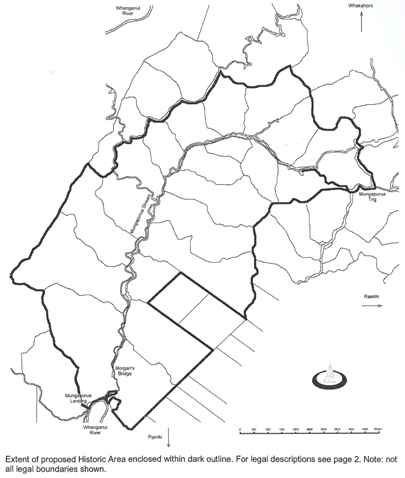
The registered historic area includes those surveyed lots within the Mangapurua Valley watershed, including all physical evidence of settlement currently present on those lands (aside from portable artifacts), which form the majority of lands offered by the government of the day for selection by discharged soldiers on 8 November 1916 including those surveyed sections that formerly formed part of the Mangapurua Road, now Part Mangapurua Scenic Reserve (refer to legal description). Total area of extent of place is 7677.8513 hectares.
Legal description
Pt CU 70005 Whanganui National Park: Secs 4 and 6 Blk I Whirinaki SD. Pt NZ Gazette 1887, p. 675. S.O. Plan 16975 (199.5100 and 318.2447 ha) Sec 7 (formerly Pt Secs 5 and 6A, Closed Road and Streambed), Blk I Whirinaki SD, Pt NZ Gazette 1887, p.675 and Pt Proclamation 1579. S.O. Plan 34567 (8.6700 ha) Sec 8 (formerly Pt Sec 5 and Closed Road), Blk I Whirinaki SD. Pt NZ Gazette 1887, p. 675 and Pt Proclamation 1579. S.O. Plan 34592 (225.4600 ha) Secs 1, 6 and 10 Blk II Whirinaki SD. Pt NZ Gazette 1887, p. 675. S.O. Plan 16975 (228.6473 and 201.9381 and 447.9870 ha) Secs 3, 4 and 8 Blk II Whirinaki SD. Pt NZ Gazette 1887, p. 675. S.O. Plan 16974 (344.3874 and 305.9423 and 199.9147 ha) Sec 11 Blk II Whirinaki SD. Proclamation 6049. S.O. Plan 19446 (7562 square metres) Secs 12 and 13 (formerly Pt Sec 9) Blk II Whirinaki SD. Pt NZ Gazette 1887, p. 675. S.O. Plan 34563 (7300 square metres and 174.9500 ha) Sec 14 (formerly Pt Sec 2) Blk II Whirinaki SD. Pt NZ Gazette 1887, p. 675. S.O. Plan 34560 (282.9000 ha) Secs 15-17 (formerly Pt Sec 7) and Sec 18 (formerly Pt Sec 2A) Blk II Whirinaki SD. Pt NZ Gazette 1887, p. 675. S.O. 34559 (101.6000 and 2.8400 and 2.0600 and 3.9200 ha) Sec 7A (formerly Pt Sec 7) and Sec 14 Blk III Whirinaki SD. Pt NZ Gazette 1887, p. 675. S.O. Plan 16974 (2.9339 and 26.0011 ha) Sec 12 (formerly Pt Sec 7) Blk III Whirinaki SD. Pt NZ Gazette 1887, p. 675. S.O. 34518 (226.4600 ha) Sec 1 Blk V Whirinaki SD. Pt NZ Gazette 1887, p. 675. S.O. Plan 17283 (690.1913 ha) Sec 2 Blk V Whirinaki SD. Pt NZ Gazette 1887, p. 675 and Pt NZ Gazette 1915, p. 821. S.O. Plan 16862 (453.6930 ha) Sec 3 Blk V Whirinaki SD. Pt NZ Gazette 1887, p. 675. S.O. Plan 17181 (220.5536ha) Sec 4 Blk V Whirinaki SD. Pt NZ Gazette 1887, p. 675. S.O. Plan 17180 (664.8985 ha) Sec 5 Blk V Whirinaki SD. Pt NZ Gazette 1915, p. 821. S.O. Plan 17181 (504.6430 ha) Sec 11 Blk VI Whirinaki SD. Pt NZ Gazette 1887, p. 675. S.O. Plan 17181 (575.8676 ha) Sec 12 (formerly Pt Sec 10 Blk VI and Pt Sec 5 and Closed Road, Blk I), Blk VI Whirinaki SD. Pt NZ Gazette 1887, p. 675 and Pt Proclamation 1579. S.O. Plan 34570 (467.4200 ha) Sec 3 Blk IX Whirinaki SD. Pt NZ Gazette 1915, p. 821. S.O. Plan 17180 (414.3981 ha) Sec 7 Blk IX Whirinaki SD. Pt NZ Gazette 1923, p. 2075. S.O. Plan 17812 (107.5452 ha) Sec 12 Blk IX Whirinaki SD. All Gazette Notice 606228.1. SO Plan 17180. (2.1195 ha) Pt CU 70810 Mangapurua Valley Scenic Reserve: Sec 4 Blk V and Sec 3 Blk IX Whirinaki SD; marked 'B' on S.O. Plan 36194 (2.8500 ha) Sec 3 Blk IX and Secs 4 and 5 Blk V Whirinaki SD; marked 'A' on S.O. Plan 36195 (3.7600 ha) Secs 1 and 5 Blk V Whirinaki SD; marked 'B' on S.O. Plan 36195 (3.1700 ha) Secs 1, 3 and 5 Blk V Whirinaki SD; marked 'A' on S.O. Plan 36196 (5.3100 ha) Secs 2 and 3 Blk V Whirinaki SD; marked 'B' on S.O. Plan 36196 (2.5500 ha) Sec 6 Blk 1 and Secs 11 and 12 Blk VI Whirinaki SD; marked 'A' on S.O. Plan 36197 (1.4580 ha) Secs 2 and 3 Blk V and Sec 11 Blk VI Whirinaki SD; marked 'B' on S.O. Plan 36197 (1.4010 ha) Secs 6, 7 and 8 Blk I and Sec 12 Blk VI Whirinaki SD; marked 'C' on S.O. Plan 36197 (4.3500 ha) Secs 4 and 8 Blk I and Sec 10 Blk II Whirinaki SD; marked 'A' on S.O. Plan 36198 (2.4100 ha) Sec 4 Blk I and Secs 1 and 6 Blk II Whirinaki SD; marked 'B' on S.O. Plan 36198 (2.8420 ha) Secs 1, 3, 11, 14, 15, 16, 17 and 18 Blk II Whirinaki SD; marked 'A' on S.O. Plan 36199 (3.9400 ha) Secs 3, 4 and 8 Blk II Whirinaki SD; marked 'B' on S.O. Plan 36199 (2.4600 ha) Secs 4, 5, 12 and 13 Blk II Whirinaki SD; marked 'A' on S.O. Plan 36200 (3.8600 ha) Sec 5 Blk II and Secs 6, 7A, 10A and 12 Blk III Whirinaki SD; marked 'A' on S.O. Plan 36201 (12.5870 ha) CU 70474 Mangatawai Conservation Area: Sec 5 Blk II Whirinaki SD. S.O. Plan 16974 (217.7208 ha)
Status
Listed
List Entry Status
Historic Area
Access
Private/No Public Access
List Number
7614
Date Entered
24th June 2005
Date of Effect
24th June 2005
City/District Council
Ruapehu District
Region
Horizons (Manawatū-Whanganui) Region
Extent of List Entry
The registered historic area includes those surveyed lots within the Mangapurua Valley watershed, including all physical evidence of settlement currently present on those lands (aside from portable artifacts), which form the majority of lands offered by the government of the day for selection by discharged soldiers on 8 November 1916 including those surveyed sections that formerly formed part of the Mangapurua Road, now Part Mangapurua Scenic Reserve (refer to legal description). Total area of extent of place is 7677.8513 hectares.
Legal description
Pt CU 70005 Whanganui National Park: Secs 4 and 6 Blk I Whirinaki SD. Pt NZ Gazette 1887, p. 675. S.O. Plan 16975 (199.5100 and 318.2447 ha) Sec 7 (formerly Pt Secs 5 and 6A, Closed Road and Streambed), Blk I Whirinaki SD, Pt NZ Gazette 1887, p.675 and Pt Proclamation 1579. S.O. Plan 34567 (8.6700 ha) Sec 8 (formerly Pt Sec 5 and Closed Road), Blk I Whirinaki SD. Pt NZ Gazette 1887, p. 675 and Pt Proclamation 1579. S.O. Plan 34592 (225.4600 ha) Secs 1, 6 and 10 Blk II Whirinaki SD. Pt NZ Gazette 1887, p. 675. S.O. Plan 16975 (228.6473 and 201.9381 and 447.9870 ha) Secs 3, 4 and 8 Blk II Whirinaki SD. Pt NZ Gazette 1887, p. 675. S.O. Plan 16974 (344.3874 and 305.9423 and 199.9147 ha) Sec 11 Blk II Whirinaki SD. Proclamation 6049. S.O. Plan 19446 (7562 square metres) Secs 12 and 13 (formerly Pt Sec 9) Blk II Whirinaki SD. Pt NZ Gazette 1887, p. 675. S.O. Plan 34563 (7300 square metres and 174.9500 ha) Sec 14 (formerly Pt Sec 2) Blk II Whirinaki SD. Pt NZ Gazette 1887, p. 675. S.O. Plan 34560 (282.9000 ha) Secs 15-17 (formerly Pt Sec 7) and Sec 18 (formerly Pt Sec 2A) Blk II Whirinaki SD. Pt NZ Gazette 1887, p. 675. S.O. 34559 (101.6000 and 2.8400 and 2.0600 and 3.9200 ha) Sec 7A (formerly Pt Sec 7) and Sec 14 Blk III Whirinaki SD. Pt NZ Gazette 1887, p. 675. S.O. Plan 16974 (2.9339 and 26.0011 ha) Sec 12 (formerly Pt Sec 7) Blk III Whirinaki SD. Pt NZ Gazette 1887, p. 675. S.O. 34518 (226.4600 ha) Sec 1 Blk V Whirinaki SD. Pt NZ Gazette 1887, p. 675. S.O. Plan 17283 (690.1913 ha) Sec 2 Blk V Whirinaki SD. Pt NZ Gazette 1887, p. 675 and Pt NZ Gazette 1915, p. 821. S.O. Plan 16862 (453.6930 ha) Sec 3 Blk V Whirinaki SD. Pt NZ Gazette 1887, p. 675. S.O. Plan 17181 (220.5536ha) Sec 4 Blk V Whirinaki SD. Pt NZ Gazette 1887, p. 675. S.O. Plan 17180 (664.8985 ha) Sec 5 Blk V Whirinaki SD. Pt NZ Gazette 1915, p. 821. S.O. Plan 17181 (504.6430 ha) Sec 11 Blk VI Whirinaki SD. Pt NZ Gazette 1887, p. 675. S.O. Plan 17181 (575.8676 ha) Sec 12 (formerly Pt Sec 10 Blk VI and Pt Sec 5 and Closed Road, Blk I), Blk VI Whirinaki SD. Pt NZ Gazette 1887, p. 675 and Pt Proclamation 1579. S.O. Plan 34570 (467.4200 ha) Sec 3 Blk IX Whirinaki SD. Pt NZ Gazette 1915, p. 821. S.O. Plan 17180 (414.3981 ha) Sec 7 Blk IX Whirinaki SD. Pt NZ Gazette 1923, p. 2075. S.O. Plan 17812 (107.5452 ha) Sec 12 Blk IX Whirinaki SD. All Gazette Notice 606228.1. SO Plan 17180. (2.1195 ha) Pt CU 70810 Mangapurua Valley Scenic Reserve: Sec 4 Blk V and Sec 3 Blk IX Whirinaki SD; marked 'B' on S.O. Plan 36194 (2.8500 ha) Sec 3 Blk IX and Secs 4 and 5 Blk V Whirinaki SD; marked 'A' on S.O. Plan 36195 (3.7600 ha) Secs 1 and 5 Blk V Whirinaki SD; marked 'B' on S.O. Plan 36195 (3.1700 ha) Secs 1, 3 and 5 Blk V Whirinaki SD; marked 'A' on S.O. Plan 36196 (5.3100 ha) Secs 2 and 3 Blk V Whirinaki SD; marked 'B' on S.O. Plan 36196 (2.5500 ha) Sec 6 Blk 1 and Secs 11 and 12 Blk VI Whirinaki SD; marked 'A' on S.O. Plan 36197 (1.4580 ha) Secs 2 and 3 Blk V and Sec 11 Blk VI Whirinaki SD; marked 'B' on S.O. Plan 36197 (1.4010 ha) Secs 6, 7 and 8 Blk I and Sec 12 Blk VI Whirinaki SD; marked 'C' on S.O. Plan 36197 (4.3500 ha) Secs 4 and 8 Blk I and Sec 10 Blk II Whirinaki SD; marked 'A' on S.O. Plan 36198 (2.4100 ha) Sec 4 Blk I and Secs 1 and 6 Blk II Whirinaki SD; marked 'B' on S.O. Plan 36198 (2.8420 ha) Secs 1, 3, 11, 14, 15, 16, 17 and 18 Blk II Whirinaki SD; marked 'A' on S.O. Plan 36199 (3.9400 ha) Secs 3, 4 and 8 Blk II Whirinaki SD; marked 'B' on S.O. Plan 36199 (2.4600 ha) Secs 4, 5, 12 and 13 Blk II Whirinaki SD; marked 'A' on S.O. Plan 36200 (3.8600 ha) Sec 5 Blk II and Secs 6, 7A, 10A and 12 Blk III Whirinaki SD; marked 'A' on S.O. Plan 36201 (12.5870 ha) CU 70474 Mangatawai Conservation Area: Sec 5 Blk II Whirinaki SD. S.O. Plan 16974 (217.7208 ha)
Why is this place significant?
Cultural Significance
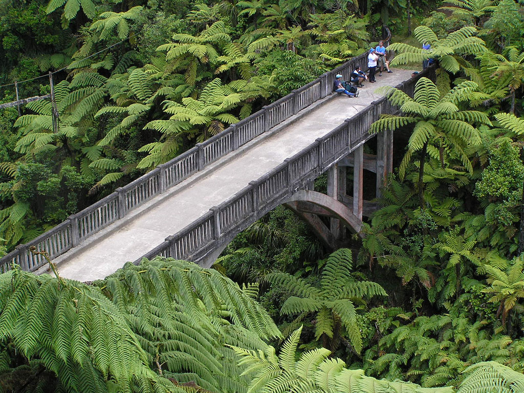
Cultural Significance As a resettlement scheme for returned servicemen from the 1914-1918 World War, the Mangapurua Valley has a strong association with the national ANZAC tradition. The Valley is a unique memorial to this tradition. The Mangapurua Valley is arguably the largest (unofficial) memorial to New Zealand Return Servicemen in New Zealand and, as such, has a direct association to the national ANZAC tradition. As part of the last large scale back country development scheme, the Valley also represents the closing stages of the pioneering era of New Zealand's histories. The remoteness and lack of easy access to/from the Valley provide a setting in which to appreciate the development of these pioneering rural communities, and associated cultures, within such landscapes prior to the existence of modern communication and infrastructure systems. Social Significance The Mangapurua Valley is an important reminder of an important developmental stage in New Zealand's social history. As part of the last large scale back country development scheme, the Valley area represents that period of government sponsored rural development schemes undertaken in the late nineteenth-early twentieth century with the aim of turning previously undeveloped lands into primary producing farmlands. Such schemes saw, across the country, large scale shifts of population, establishment of both temporary and permanent settlements and dramatic changes on the land in association with sub-division, forestry and, finally, farming activity. The Valley is also representative of the form of social environment in which many of New Zealand's rural communities developed in the first half of the twentieth century. With only the most basic of communication infrastructure, localities such as the Mangapurua Valley formed tight communities where the primary sources of assistance, friendships, and social events occurred within that community. Abandonment, and subsequent return to ownership by the Crown, has preserved the nature of this remote environment within which much of New Zealand's twentieth century social histories developed whereas other similar examples have either been incorporated into larger farm holdings or, if less remote, been subject to modern communication infrastructure and, consequently, a loss of that original social fabric. Within the Mangapurua Valley is one of New Zealand's most recognisable cultural heritage icons, Morgan's Bridge ('Bridge to Nowhere'). This structure has a Category I Historic Places Trust Classification (Record Number 7168) and is integrally related to the histories and settlement of the Valley itself. The physical remains of two former house sites in the Valley, Bettjeman's and Johnson's, are Actively Managed by the Department of Conservation as Historical Assets. The Department plans to add other physical evidence, such as ploughs, exotic vegetation, gates, fencing, culverts and bridge remains, to that list of Actively Managed Historical Assets contained within the Mangapurua Valley. The Department of Conservation actively promotes and markets the Valley as a 3 day tramp through an area associated New Zealand's historic past. The Department also closely associates the Mangapurua Valley and remnants of settlement with the historical aspects of the Whanganui River and Whakahoro Hut (located at the mouth of the Kaiwhakauka Valley and marketed by the Department of Conservation as the starting/end point for visits to the Valley). The recreational use and historical importance of the Mangapurua Valley is also well recognised outside of the heritage community. Aside from private trampers and tour groups lead by Whanganui River Concessionaires from the Whanganui River to Morgan's Bridge, the Valley is well frequented by tramping clubs, hunters and the occasional historic tour group. Arthur Bates' 'Bridge to Nowhere', originally published in 1981 and now in its' eight edition, tells the story of the Valley settlement and is a popular publication. Friends of the Whanganui Annuals often contain short stories relating to the settlement and historic features of the Valley. Neighbouring landowners and descendants of the Valley settlers are interested in, and regularly enquire from the Department of Conservation information about, management of the historical assets located in the Valley. Mangapurua Valley is a publicly owned and accessible example of the types of landscape opened up for settlement and development by the Crown towards the close of the era of large scale landscape development schemes. All former house sites, farms and other evidence of the settlement can be visited and explored. Much of the more remote farmlands have been subject to regenerating bush cover. The greatest asset of the Mangapurua Valley is its educational value. Visitors go into the Valley to inspect and learn, first hand, about the environment and trials faced by the settlers of this Valley. The physical remains of the settlement serve to provide an on site context for this learning experience. As part of the Whanganui National Park/Mangapurua Valley Scenic Reserve public access to the Valley is encouraged through active promotion of the Valley by the Department of Conservation. Aside from transport costs, there are no charges to walk the Valley.
Historic Significance
Historical Significance or Value Historical Significance The Mangapurua Valley is historically significant because it was part of the last large scale back country pioneering development scheme in New Zealand. Land in the Mangapurua Valley and the nearby Kaiwhakauka Valley was offered under the Discharged Soldiers Settlement Act 1915, and its subsequent amendment, to soldiers returning from military service during the 1914-18 World War. At the height of settlement just under forty returned servicemen, and their families, resided in the Mangapurua Valley. Due to economic and physical hardships resulting from the Valley's remoteness and ruggedness, unstable lands and unsuitability for small scale farming operations the scheme was a failure and by 1942 just three farmers and their families remained in the Valley. That year Cabinet made the decision that road access to the Valley would no longer be maintained and by 1943 every person had left the Valley. The Mangapurua Valley reflects government-sponsored, large-scale, back-country development schemes of the late nineteenth-early twentieth century. Such developments served to open previously unproductive lands for development, provide a foundation for New Zealand's reliance on farming for the local and national economy, and established a social environment which was to shape the social histories of New Zealand until the 1970's. The Mangapurua Valley is the most notable of a number of such schemes which failed due to a variety of reasons, such as small run size, unsuitable soils and financial reasons, however, in the case of the Mangapurua Valley, the land involved was not incorporated into larger, profitable, run holdings. The failure of the development scheme is, in itself, an important historical event as that failure not only marked the end of the use of these schemes on such an ambitious scale but also help led, in the 1950's and 1960's, to a better study and understanding of New Zealand's environment and the effects intensive land clearance and farming activity would have on those lands. Much smaller scaled re-settlement schemes, based on the use of more suitable lands, were used for the settlement of discharged soldiers during and shortly after the 1939-1945 War. The Valley also serves as a reminder of the national ANZAC tradition and is a direct link to those service personal who served in the 1914-18 World War. The traditional ANZAC imagery of soldiers fostered during and after both World Wars who were larger than life and capable of taking on the most arduous of tasks is enshrined in this Valley's remoteness and ruggedness.
Physical Significance
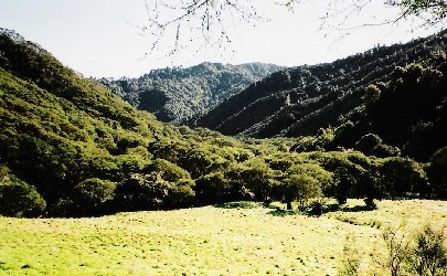
Aesthetic Significance The experience of remoteness and ruggedness imparted on the visitor gives the Mangapurua Valley significant aesthetic value when placed in the context of the histories of that Valley. Reclamation of house sites and other activity areas by regenerating bush provide an experience rarely encountered on such a large scale.
Why is this place significant?
Cultural Significance
Cultural Significance As a resettlement scheme for returned servicemen from the 1914-1918 World War, the Mangapurua Valley has a strong association with the national ANZAC tradition. The Valley is a unique memorial to this tradition. The Mangapurua Valley is arguably the largest (unofficial) memorial to New Zealand Return Servicemen in New Zealand and, as such, has a direct association to the national ANZAC tradition. As part of the last large scale back country development scheme, the Valley also represents the closing stages of the pioneering era of New Zealand's histories. The remoteness and lack of easy access to/from the Valley provide a setting in which to appreciate the development of these pioneering rural communities, and associated cultures, within such landscapes prior to the existence of modern communication and infrastructure systems. Social Significance The Mangapurua Valley is an important reminder of an important developmental stage in New Zealand's social history. As part of the last large scale back country development scheme, the Valley area represents that period of government sponsored rural development schemes undertaken in the late nineteenth-early twentieth century with the aim of turning previously undeveloped lands into primary producing farmlands. Such schemes saw, across the country, large scale shifts of population, establishment of both temporary and permanent settlements and dramatic changes on the land in association with sub-division, forestry and, finally, farming activity. The Valley is also representative of the form of social environment in which many of New Zealand's rural communities developed in the first half of the twentieth century. With only the most basic of communication infrastructure, localities such as the Mangapurua Valley formed tight communities where the primary sources of assistance, friendships, and social events occurred within that community. Abandonment, and subsequent return to ownership by the Crown, has preserved the nature of this remote environment within which much of New Zealand's twentieth century social histories developed whereas other similar examples have either been incorporated into larger farm holdings or, if less remote, been subject to modern communication infrastructure and, consequently, a loss of that original social fabric. Within the Mangapurua Valley is one of New Zealand's most recognisable cultural heritage icons, Morgan's Bridge ('Bridge to Nowhere'). This structure has a Category I Historic Places Trust Classification (Record Number 7168) and is integrally related to the histories and settlement of the Valley itself. The physical remains of two former house sites in the Valley, Bettjeman's and Johnson's, are Actively Managed by the Department of Conservation as Historical Assets. The Department plans to add other physical evidence, such as ploughs, exotic vegetation, gates, fencing, culverts and bridge remains, to that list of Actively Managed Historical Assets contained within the Mangapurua Valley. The Department of Conservation actively promotes and markets the Valley as a 3 day tramp through an area associated New Zealand's historic past. The Department also closely associates the Mangapurua Valley and remnants of settlement with the historical aspects of the Whanganui River and Whakahoro Hut (located at the mouth of the Kaiwhakauka Valley and marketed by the Department of Conservation as the starting/end point for visits to the Valley). The recreational use and historical importance of the Mangapurua Valley is also well recognised outside of the heritage community. Aside from private trampers and tour groups lead by Whanganui River Concessionaires from the Whanganui River to Morgan's Bridge, the Valley is well frequented by tramping clubs, hunters and the occasional historic tour group. Arthur Bates' 'Bridge to Nowhere', originally published in 1981 and now in its' eight edition, tells the story of the Valley settlement and is a popular publication. Friends of the Whanganui Annuals often contain short stories relating to the settlement and historic features of the Valley. Neighbouring landowners and descendants of the Valley settlers are interested in, and regularly enquire from the Department of Conservation information about, management of the historical assets located in the Valley. Mangapurua Valley is a publicly owned and accessible example of the types of landscape opened up for settlement and development by the Crown towards the close of the era of large scale landscape development schemes. All former house sites, farms and other evidence of the settlement can be visited and explored. Much of the more remote farmlands have been subject to regenerating bush cover. The greatest asset of the Mangapurua Valley is its educational value. Visitors go into the Valley to inspect and learn, first hand, about the environment and trials faced by the settlers of this Valley. The physical remains of the settlement serve to provide an on site context for this learning experience. As part of the Whanganui National Park/Mangapurua Valley Scenic Reserve public access to the Valley is encouraged through active promotion of the Valley by the Department of Conservation. Aside from transport costs, there are no charges to walk the Valley.
Historic Significance
Historical Significance or Value Historical Significance The Mangapurua Valley is historically significant because it was part of the last large scale back country pioneering development scheme in New Zealand. Land in the Mangapurua Valley and the nearby Kaiwhakauka Valley was offered under the Discharged Soldiers Settlement Act 1915, and its subsequent amendment, to soldiers returning from military service during the 1914-18 World War. At the height of settlement just under forty returned servicemen, and their families, resided in the Mangapurua Valley. Due to economic and physical hardships resulting from the Valley's remoteness and ruggedness, unstable lands and unsuitability for small scale farming operations the scheme was a failure and by 1942 just three farmers and their families remained in the Valley. That year Cabinet made the decision that road access to the Valley would no longer be maintained and by 1943 every person had left the Valley. The Mangapurua Valley reflects government-sponsored, large-scale, back-country development schemes of the late nineteenth-early twentieth century. Such developments served to open previously unproductive lands for development, provide a foundation for New Zealand's reliance on farming for the local and national economy, and established a social environment which was to shape the social histories of New Zealand until the 1970's. The Mangapurua Valley is the most notable of a number of such schemes which failed due to a variety of reasons, such as small run size, unsuitable soils and financial reasons, however, in the case of the Mangapurua Valley, the land involved was not incorporated into larger, profitable, run holdings. The failure of the development scheme is, in itself, an important historical event as that failure not only marked the end of the use of these schemes on such an ambitious scale but also help led, in the 1950's and 1960's, to a better study and understanding of New Zealand's environment and the effects intensive land clearance and farming activity would have on those lands. Much smaller scaled re-settlement schemes, based on the use of more suitable lands, were used for the settlement of discharged soldiers during and shortly after the 1939-1945 War. The Valley also serves as a reminder of the national ANZAC tradition and is a direct link to those service personal who served in the 1914-18 World War. The traditional ANZAC imagery of soldiers fostered during and after both World Wars who were larger than life and capable of taking on the most arduous of tasks is enshrined in this Valley's remoteness and ruggedness.
Physical Significance
Aesthetic Significance The experience of remoteness and ruggedness imparted on the visitor gives the Mangapurua Valley significant aesthetic value when placed in the context of the histories of that Valley. Reclamation of house sites and other activity areas by regenerating bush provide an experience rarely encountered on such a large scale.
A useful social history of the Valley and its' settlers may be found in Arthur Bates' (2003) The Bridge to Nowhere and in individual publications of Friends of the Whanganui River. The follow is based on Bates (2003) and file notes held at the Wanganui Conservancy office, Department of Conservation. The Mangapurua Valley was not surveyed for settlement purposes until the early years of the second decade of the twentieth century. Prior to this Māori utilised the Valley for the purposes of obtaining supplementary resources, such as eel, birds and totara for canoes. Aside from the rare 'spot find' the Valley does not appear, for a variety of possible reasons, to have been subject to prehistoric settlement activity. In 1895, the Waimarino B Block, which included the Mangapurua Valley, was allocated to 194 owners of the Ngati Hinekura, Ngati Matakaha, and the Ngati Ngaarero hapu. The block was partitioned into three sections, Waimarino B1, B2, and B3 in 1909. Waimarino B1, sold in 1913, would not form part of what became known as the Mangapurua Valley settlement. Waimarino B2, which consisted of 502 acres, remained in Maori ownership, although Turakina farmer Wilfred Atkins was granted full lease rights to the land after 1911. The largest block Waimarino 3B, which consisted of 8184 acres, also remained in Maori ownership, but by 1911 had been subdivided into four different sections. In 1911, the government made an unsuccessful offer of £5794 for ownership of the three Waimarino B blocks. Made prior to the need for 'soldier settlements', the offer may have been part of a larger plan to open up 'back-country' for settlement purposes, as early reports on the agricultural potential of the Waimarino B were 'encouraging'. In December 1912, the Department of Lands began lobbying the Native Department to purchase the Waimarino B block, on the grounds that the acquisition of the block would allow the construction of more practical fence-lines for proposed settlements in the Mangapurua Valley. A second, unsuccessful attempt to purchase the land was made in 1913. In 1915, however, the government obtained ownership of three of the four sections that had made up the original Waimarino 3B block. All attempts to purchase the last section, the 201 acres in Waimarino B3A, were unsuccessful, and the section remains in Maori hands today. The government purchased the largest remaining section, Waimarino B2B3B (6915 acres), on 4 March 1915. Although the land was then owned by 178 owners, the agreement to purchase consented to by just 6 of those owners, a practice made legal under the provisions of the Native Land Act 1909. Peter Clayworth notes that, although no objections to the sale were made in later months, it is unclear how well informed the remaining owners were about the sale of the block. The government obtained ownership of Waimarino B3B1 (393 acres), from its Maori landowners in May that same year, and by November, it had also acquired Waimarino B3B2A (675 acres). In September 1915, two months prior to the purchase of Waimarino B3B2A, the Right Hon. Mr Massey (Minister of Lands) introduced the Discharged Soldier's Settlement Bill into Parliament. Following an amending Bill introduced in June 1916, provision was made available for the government of the day to compulsory purchase under the Lands for Settlement Act or otherwise acquire land, including Crown lands, for the purposes of the settlement of return servicemen from the British Empire's forces at that time. A substantial fund for improvements of those lands was also provided. Such settlement schemes were characteristic of the manner in which the rural areas of New Zealand were opened up in the late nineteenth and early twentieth centuries. These schemes not only provided land for settlement but helped support a growing economy. In his summary of the Discharged Soldier's Settlement Amendment Bill (1916) the Right Hon. Mr Massey stated; That when the war comes to an end, we shall find we are carrying on the war; there will be interest and sinking funds on the loans we have raised; there will be pensions to be paid ... we should do all we possibly can to increase the number of our producers, to increase the quantity of our exports, to, if possible, increase their value, and at the same time increase the wealth of the country. (quoted in Bates 2003:12) The districts in which these land grants were to be made were not specified in the Discharged Soldier's Settlement Act 1915 and subsequent amendment. However parliamentary debates during 1915 and 1916 referred to fruit growing in Nelson and Central Otago and poultry farming in the Auckland district. The roughed areas of the Whanganui River Valley were never referred to in these debates. However by June 1916 Massey was stating; Unfortunately, we have reached this position, as far as our Crown lands are concerned; that there is practically no first-class land left. There is considerable area of second-class land; but even in the case of the second-class land it is often remote and difficult of access either by road or railway ... Even in the case of privately owned land, large blocks of good agricultural land are much scarcer and not so easily obtainable as many people imagine them to be. I have heard it repeated over and over again during the course of this debate that none of these settlers must be asked to go out in the bush country ... but I do say this: That, taking a man who is sound, strong, and young, and possessed of sufficient energy and ability - I honestly believe that the average of such men will do very much better both for themselves and the country if they go out into the backblocks ... A man who goes out into the bush ... and makes a home for himself, and produces stock, and brings up a family is doing more for the country than the man who takes up improved land ... (quoted in Bates 2003:12-13) It was in this political and social background that the Government's attention once again returned to the Whanganui River Valley in general and Mangapurua Valley specifically. Although not initially offered for sale due to the slow sales of surveyed lands in the neighbouring Mangatiti Valley, the land in the Mangapurua Valley had been recently surveyed and it was considered by the government to be land with encouraging possibilities for farming. The survey indicated that, at the time, the only settlement in the Valley was 'Mr Barn's camp' which, according to the notes of the supervising surveyor, W. Steward, was located 6½ miles down the Valley from Mangapurua Trig, that is, in the vicinity of Hellawell's or Ward's house sites. On 8th November 1916, the Mangapurua Soldier's Settlement, comprising 44,839 acres in the Mangapurua and Kaiwhakauka Valleys, were advertised for selection. In the general description of Sale Plan 730 the area being offered is described as; The block consists of undulating to steep hilly country, soil fair to good resting on sandstone and papa formation, and varying in altitude from 370 feet to about 1,850 feet above sea level, all in virgin bush which, when cleared and grassed, will make good grazing country suitable for sheep and cattle. Roads are unformed at present, but horse tracks are being provided ... The horse tracks will be extended as required and widened to dray roads when labour is available. Forty-one sections, the majority being in that area which can be delineated as the Mangapurua Valley watershed, were advertised for leasehold tenure selection. Road Reserves were established along the main access routes although these roads were not developed much beyond horse tracks for some years, if at all. Within the Mangapurua Valley, all sections had paper access to permanent streams, including the Mangapurua, and, in some cases, by the addition of small specially created adjunct sections to the primary property. The terms and conditions of acquisition of sections by the discharged servicemen included; · each applicant be satisfied, either personally or by proxy, that the land offered will suit their requirements, · that the property, license or lease may not be transferred for a period of ten years of the date of the original agreement. These sections were made available by; · cash sale, · deferred payment license requiring payment five percent of capital value and the balance payable by equal instalments over nineteen years with interest being charged at five percent, or · renewable lease, with right of purchase, for 66 years with compulsory residence and improvements. It appears, from appeals to government of the day during the Depression era about the difficulty in meeting both rental and interest payments, that many of the successful applicants obtained their sections under the third, that is renewable lease, option. Opening of the Mangapurua Valley to discharged servicemen did not meet with universal approval. In a letter addressed to the Commissioner of Crown Lands, the Crown Land Ranger at Piriaka at that time commented; I have the honour to inform you that when I was in the Kaitieke Valley yesterday, the settlers I met spoke very strongly against the action of the department in settling discharged soldiers on the Retaruke and other blocks in that vicinity. From my knowledge of the country, I am of the opinion that the land is too rough and too far back for men with shattered nerves. (quoted in Bates 2003:16) Upon inspecting the section being offered, potential settlers found that communication along the Valley was both undeveloped and hazardous, section boundaries did not follow natural features such as ridgelines and streams and that the majority of land contained within those sections was often rugged in nature, and access to streams was hindered by deep wall-sided gorges which were often impracticable to cross to neighbouring land in the same section. Those settlers who persevered with these conditions were to find out that upon removal of bush cover that the greasy sandstone and papa based hillsides became susceptible to erosion and, once farmed for a few years, were lacking in sufficient nutrients for the farms to be considered productive. By the early 1920's the majority of land made available in the Mangapurua Valley under the Mangapurua Soldier's Settlement scheme had been taken up. Despite the earlier assurances to the contrary by Massey, many of those ex-servicemen who settled these lands had been invalided out of the armed forces. Those sections that were unselected or surrendered at a later date were re-offered on occasion until the mid 1930's however re-selection of these blocks was poor. The establishment of farms in the Valley generally followed a standard process. Having been successful in securing a section, the discharged soldier proceeded to establish a base camp on their section from where initial land clearance operations were carried out. In some instances, single men would often form a partnership with another discharged soldier to secure and farm a particular section and it was Land Board policy that larger sections were granted to such partnerships. These partnerships had the advantage of being eligible for double the farm establishment funding (₤750 each) and ensuring an adequate supply of labour to undertake land clearance. However such partnerships often were soon dissolved when it became apparent that the land could not support two incomes and one of the partners would 'sell up' or 'walk off the land'. Married, or engaged, men would often enter the Valley alone and set about initial land clearance of their section. The remoteness and rugged nature of the Valley, along with the fact that all were soldier-settlers recently returned from active duty, quickly created a community where neighbourly assistance was always available, and often supplied without request, should a large or difficult job be planned. This culture of community assistance was to remain with the soldier-settlers and their families until the Valley's closure. The base camps of the soldier-settlers were rudimentary affairs. Jack Ward, who settled in the Valley in 1917, recalls; Tents at that time, owing to the war, were scarcer than hen's teeth, but I was lucky to get hold of a good tarpaulin measuring 16 x 14 feet and I reckoned that, with pongas cut to fit the walls, this would make a good sort of camp cover. Included in the tools ... were axes with spare handles, slashers, a grindstone, two camp ovens, three billies, kerosene, a lamp and candles, plus a reasonable amount of stores, especially tinned meat, as wild pork was the only fresh meat available up there, and had to be caught ... (Bates 2003:32) The camp supplies were to be shared between Ward and, another soldier-settler, Ken Wilson. The Valley was, generally, settled progressively from both ends, that from Mangapurua Landing and Mangapurua Trig. Horse tracks had not been formed within the Valley during the initial stages of settlement and, as a consequence, all materials landed by the riverboats at the Landing end were brought up the Valley by back-pack. Those soldier-settlers who arrived in the Valley by riverboat then had the difficulty of negotiating the Mangapurua Stream, the most convenient place being near the location of Morgan's Bridge. Initially this involved following a narrow, greasy, track down a 130 ft steep bank to the Stream, fording that stream, and then climbing back up the equally difficult other side. The difficulties and time involved in doing this saw the construction of a rather insecure and nerve-racking pulley cage system across the 114 ft gap in 1917 and, two years later, a narrow suspension span bridge which lasted until the completion of Morgan's Bridge in 1936. The remains of this suspension bridge may be still seen today upriver from Morgan's Bridge. Following establishment of their base camp and clearance of land around that camp, which included burning of the cut bush, the next step was to establish a more permanent dwelling. This was usually in the form of a slab hut or similar structure. As well as initial land clearance and construction of a basic hut, the soldier-settlers helped the Public Works workers with the construction of a more traversable horse track into the Valley. It was at this time that the wives of any married soldier-settlers and horse or pack animals arrived. Some of the more progressively advanced settlers also brought in the odd cattle beast or two for the supply of fresh milk. It was at this stage of Valley development that the first series of soldier-settlers left the land. With 6 - 18 months experience of conditions in the Valley it had become apparent to some that their land would either not support a farming income or was too rugged to 'break in' by hand. With no other family members to support, the majority of setters to leave the land were single men. Due to the temporary nature of the materials used in the establishing of these base camps or slab huts no evidence, aside from the occasional clearance in the bush, remains of this phase of Valley settlement. An interesting visible remnant of the initial uptake of land allocations is Burman's farm. In 1920 Bill Burman went into the Valley to take up his allocated land. Upon viewing the lot Burman promptly abandoned his allocation and left the Valley (Bates 2003:63). This tract of land, located near the Mangapurua Trig, is the only substantial area of virgin bush remaining today in the Valley. Once a basic farm operation was established the settlers began to construct more permanent dwellings. At the same time, a more accessible dray track had been formed into the Valley from Raetihi via Ruatiti. This permitted the settlers to bring in more robust building materials, such as glass, concrete and brick, and some elementary household furniture and fittings. The remains of these permanent structures include chimneys, water tanks and piping. While the return servicemen concentrated on farming the land, the women set about creating a home for the family. As well as managing the home and looking after any children this often included looking after livestock kept in paddocks next to the farm buildings, which supplied fresh foods such as milk and eggs, and tending the garden. Today the posts and, in some cases, wiring of the fences of these smaller paddocks and enclosures remain and, while no trace is left of the vegetable gardens, evidence of ornamental gardens may be seen in the form of free-growing exotic species. To support the growing Valley community effort was made to develop the access track from Ruatiti to the Mangapurua Valley. This track generally followed the true left bank of the Mangapurua Stream and was intended to form part of an east-west route between the Waimarino and Taranaki regions. Within the Valley construction of the road was to involve the bridging of a number of gorges including the Mangapurua Stream at Morgan's Bridge, widening of the pack track to accommodate motorised transport, culverting of small seasonal waterways and stepping of a series of high bluffs. While constructed by the Public Works Department, or their contractors, many of the settlers in the Valley supplemented their farm incomes in the early years by assisting on the construction of the road. Today much of the line of the original road remains and is visible as metalled sections of the Mangapurua Valley Walking Track. Other remnants of the road include timber supports for the deeply gorged stream crossings, Morgan's Bridge (a Registered Historic Place), and concrete and wood culverts. By 1926 there were sufficient children in the Valley to open a school. The school was run from the abandoned Tester house. For the next eight years the roll fluctuated between five and thirteen with some children riding up to 10 miles in each direction each school day. In 1933 the Tester's building burnt down and, given that the school roll was then thirteen students, the Education Department decided to erect a portable building in its place. This new school was located on two acres of land, given by the McDonalds, closer to the centre of the Valley.
A useful social history of the Valley and its' settlers may be found in Arthur Bates' (2003) The Bridge to Nowhere and in individual publications of Friends of the Whanganui River. The follow is based on Bates (2003) and file notes held at the Wanganui Conservancy office, Department of Conservation. The Mangapurua Valley was not surveyed for settlement purposes until the early years of the second decade of the twentieth century. Prior to this Māori utilised the Valley for the purposes of obtaining supplementary resources, such as eel, birds and totara for canoes. Aside from the rare 'spot find' the Valley does not appear, for a variety of possible reasons, to have been subject to prehistoric settlement activity. In 1895, the Waimarino B Block, which included the Mangapurua Valley, was allocated to 194 owners of the Ngati Hinekura, Ngati Matakaha, and the Ngati Ngaarero hapu. The block was partitioned into three sections, Waimarino B1, B2, and B3 in 1909. Waimarino B1, sold in 1913, would not form part of what became known as the Mangapurua Valley settlement. Waimarino B2, which consisted of 502 acres, remained in Maori ownership, although Turakina farmer Wilfred Atkins was granted full lease rights to the land after 1911. The largest block Waimarino 3B, which consisted of 8184 acres, also remained in Maori ownership, but by 1911 had been subdivided into four different sections. In 1911, the government made an unsuccessful offer of £5794 for ownership of the three Waimarino B blocks. Made prior to the need for 'soldier settlements', the offer may have been part of a larger plan to open up 'back-country' for settlement purposes, as early reports on the agricultural potential of the Waimarino B were 'encouraging'. In December 1912, the Department of Lands began lobbying the Native Department to purchase the Waimarino B block, on the grounds that the acquisition of the block would allow the construction of more practical fence-lines for proposed settlements in the Mangapurua Valley. A second, unsuccessful attempt to purchase the land was made in 1913. In 1915, however, the government obtained ownership of three of the four sections that had made up the original Waimarino 3B block. All attempts to purchase the last section, the 201 acres in Waimarino B3A, were unsuccessful, and the section remains in Maori hands today. The government purchased the largest remaining section, Waimarino B2B3B (6915 acres), on 4 March 1915. Although the land was then owned by 178 owners, the agreement to purchase consented to by just 6 of those owners, a practice made legal under the provisions of the Native Land Act 1909. Peter Clayworth notes that, although no objections to the sale were made in later months, it is unclear how well informed the remaining owners were about the sale of the block. The government obtained ownership of Waimarino B3B1 (393 acres), from its Maori landowners in May that same year, and by November, it had also acquired Waimarino B3B2A (675 acres). In September 1915, two months prior to the purchase of Waimarino B3B2A, the Right Hon. Mr Massey (Minister of Lands) introduced the Discharged Soldier's Settlement Bill into Parliament. Following an amending Bill introduced in June 1916, provision was made available for the government of the day to compulsory purchase under the Lands for Settlement Act or otherwise acquire land, including Crown lands, for the purposes of the settlement of return servicemen from the British Empire's forces at that time. A substantial fund for improvements of those lands was also provided. Such settlement schemes were characteristic of the manner in which the rural areas of New Zealand were opened up in the late nineteenth and early twentieth centuries. These schemes not only provided land for settlement but helped support a growing economy. In his summary of the Discharged Soldier's Settlement Amendment Bill (1916) the Right Hon. Mr Massey stated; That when the war comes to an end, we shall find we are carrying on the war; there will be interest and sinking funds on the loans we have raised; there will be pensions to be paid ... we should do all we possibly can to increase the number of our producers, to increase the quantity of our exports, to, if possible, increase their value, and at the same time increase the wealth of the country. (quoted in Bates 2003:12) The districts in which these land grants were to be made were not specified in the Discharged Soldier's Settlement Act 1915 and subsequent amendment. However parliamentary debates during 1915 and 1916 referred to fruit growing in Nelson and Central Otago and poultry farming in the Auckland district. The roughed areas of the Whanganui River Valley were never referred to in these debates. However by June 1916 Massey was stating; Unfortunately, we have reached this position, as far as our Crown lands are concerned; that there is practically no first-class land left. There is considerable area of second-class land; but even in the case of the second-class land it is often remote and difficult of access either by road or railway ... Even in the case of privately owned land, large blocks of good agricultural land are much scarcer and not so easily obtainable as many people imagine them to be. I have heard it repeated over and over again during the course of this debate that none of these settlers must be asked to go out in the bush country ... but I do say this: That, taking a man who is sound, strong, and young, and possessed of sufficient energy and ability - I honestly believe that the average of such men will do very much better both for themselves and the country if they go out into the backblocks ... A man who goes out into the bush ... and makes a home for himself, and produces stock, and brings up a family is doing more for the country than the man who takes up improved land ... (quoted in Bates 2003:12-13) It was in this political and social background that the Government's attention once again returned to the Whanganui River Valley in general and Mangapurua Valley specifically. Although not initially offered for sale due to the slow sales of surveyed lands in the neighbouring Mangatiti Valley, the land in the Mangapurua Valley had been recently surveyed and it was considered by the government to be land with encouraging possibilities for farming. The survey indicated that, at the time, the only settlement in the Valley was 'Mr Barn's camp' which, according to the notes of the supervising surveyor, W. Steward, was located 6½ miles down the Valley from Mangapurua Trig, that is, in the vicinity of Hellawell's or Ward's house sites. On 8th November 1916, the Mangapurua Soldier's Settlement, comprising 44,839 acres in the Mangapurua and Kaiwhakauka Valleys, were advertised for selection. In the general description of Sale Plan 730 the area being offered is described as; The block consists of undulating to steep hilly country, soil fair to good resting on sandstone and papa formation, and varying in altitude from 370 feet to about 1,850 feet above sea level, all in virgin bush which, when cleared and grassed, will make good grazing country suitable for sheep and cattle. Roads are unformed at present, but horse tracks are being provided ... The horse tracks will be extended as required and widened to dray roads when labour is available. Forty-one sections, the majority being in that area which can be delineated as the Mangapurua Valley watershed, were advertised for leasehold tenure selection. Road Reserves were established along the main access routes although these roads were not developed much beyond horse tracks for some years, if at all. Within the Mangapurua Valley, all sections had paper access to permanent streams, including the Mangapurua, and, in some cases, by the addition of small specially created adjunct sections to the primary property. The terms and conditions of acquisition of sections by the discharged servicemen included; · each applicant be satisfied, either personally or by proxy, that the land offered will suit their requirements, · that the property, license or lease may not be transferred for a period of ten years of the date of the original agreement. These sections were made available by; · cash sale, · deferred payment license requiring payment five percent of capital value and the balance payable by equal instalments over nineteen years with interest being charged at five percent, or · renewable lease, with right of purchase, for 66 years with compulsory residence and improvements. It appears, from appeals to government of the day during the Depression era about the difficulty in meeting both rental and interest payments, that many of the successful applicants obtained their sections under the third, that is renewable lease, option. Opening of the Mangapurua Valley to discharged servicemen did not meet with universal approval. In a letter addressed to the Commissioner of Crown Lands, the Crown Land Ranger at Piriaka at that time commented; I have the honour to inform you that when I was in the Kaitieke Valley yesterday, the settlers I met spoke very strongly against the action of the department in settling discharged soldiers on the Retaruke and other blocks in that vicinity. From my knowledge of the country, I am of the opinion that the land is too rough and too far back for men with shattered nerves. (quoted in Bates 2003:16) Upon inspecting the section being offered, potential settlers found that communication along the Valley was both undeveloped and hazardous, section boundaries did not follow natural features such as ridgelines and streams and that the majority of land contained within those sections was often rugged in nature, and access to streams was hindered by deep wall-sided gorges which were often impracticable to cross to neighbouring land in the same section. Those settlers who persevered with these conditions were to find out that upon removal of bush cover that the greasy sandstone and papa based hillsides became susceptible to erosion and, once farmed for a few years, were lacking in sufficient nutrients for the farms to be considered productive. By the early 1920's the majority of land made available in the Mangapurua Valley under the Mangapurua Soldier's Settlement scheme had been taken up. Despite the earlier assurances to the contrary by Massey, many of those ex-servicemen who settled these lands had been invalided out of the armed forces. Those sections that were unselected or surrendered at a later date were re-offered on occasion until the mid 1930's however re-selection of these blocks was poor. The establishment of farms in the Valley generally followed a standard process. Having been successful in securing a section, the discharged soldier proceeded to establish a base camp on their section from where initial land clearance operations were carried out. In some instances, single men would often form a partnership with another discharged soldier to secure and farm a particular section and it was Land Board policy that larger sections were granted to such partnerships. These partnerships had the advantage of being eligible for double the farm establishment funding (₤750 each) and ensuring an adequate supply of labour to undertake land clearance. However such partnerships often were soon dissolved when it became apparent that the land could not support two incomes and one of the partners would 'sell up' or 'walk off the land'. Married, or engaged, men would often enter the Valley alone and set about initial land clearance of their section. The remoteness and rugged nature of the Valley, along with the fact that all were soldier-settlers recently returned from active duty, quickly created a community where neighbourly assistance was always available, and often supplied without request, should a large or difficult job be planned. This culture of community assistance was to remain with the soldier-settlers and their families until the Valley's closure. The base camps of the soldier-settlers were rudimentary affairs. Jack Ward, who settled in the Valley in 1917, recalls; Tents at that time, owing to the war, were scarcer than hen's teeth, but I was lucky to get hold of a good tarpaulin measuring 16 x 14 feet and I reckoned that, with pongas cut to fit the walls, this would make a good sort of camp cover. Included in the tools ... were axes with spare handles, slashers, a grindstone, two camp ovens, three billies, kerosene, a lamp and candles, plus a reasonable amount of stores, especially tinned meat, as wild pork was the only fresh meat available up there, and had to be caught ... (Bates 2003:32) The camp supplies were to be shared between Ward and, another soldier-settler, Ken Wilson. The Valley was, generally, settled progressively from both ends, that from Mangapurua Landing and Mangapurua Trig. Horse tracks had not been formed within the Valley during the initial stages of settlement and, as a consequence, all materials landed by the riverboats at the Landing end were brought up the Valley by back-pack. Those soldier-settlers who arrived in the Valley by riverboat then had the difficulty of negotiating the Mangapurua Stream, the most convenient place being near the location of Morgan's Bridge. Initially this involved following a narrow, greasy, track down a 130 ft steep bank to the Stream, fording that stream, and then climbing back up the equally difficult other side. The difficulties and time involved in doing this saw the construction of a rather insecure and nerve-racking pulley cage system across the 114 ft gap in 1917 and, two years later, a narrow suspension span bridge which lasted until the completion of Morgan's Bridge in 1936. The remains of this suspension bridge may be still seen today upriver from Morgan's Bridge. Following establishment of their base camp and clearance of land around that camp, which included burning of the cut bush, the next step was to establish a more permanent dwelling. This was usually in the form of a slab hut or similar structure. As well as initial land clearance and construction of a basic hut, the soldier-settlers helped the Public Works workers with the construction of a more traversable horse track into the Valley. It was at this time that the wives of any married soldier-settlers and horse or pack animals arrived. Some of the more progressively advanced settlers also brought in the odd cattle beast or two for the supply of fresh milk. It was at this stage of Valley development that the first series of soldier-settlers left the land. With 6 - 18 months experience of conditions in the Valley it had become apparent to some that their land would either not support a farming income or was too rugged to 'break in' by hand. With no other family members to support, the majority of setters to leave the land were single men. Due to the temporary nature of the materials used in the establishing of these base camps or slab huts no evidence, aside from the occasional clearance in the bush, remains of this phase of Valley settlement. An interesting visible remnant of the initial uptake of land allocations is Burman's farm. In 1920 Bill Burman went into the Valley to take up his allocated land. Upon viewing the lot Burman promptly abandoned his allocation and left the Valley (Bates 2003:63). This tract of land, located near the Mangapurua Trig, is the only substantial area of virgin bush remaining today in the Valley. Once a basic farm operation was established the settlers began to construct more permanent dwellings. At the same time, a more accessible dray track had been formed into the Valley from Raetihi via Ruatiti. This permitted the settlers to bring in more robust building materials, such as glass, concrete and brick, and some elementary household furniture and fittings. The remains of these permanent structures include chimneys, water tanks and piping. While the return servicemen concentrated on farming the land, the women set about creating a home for the family. As well as managing the home and looking after any children this often included looking after livestock kept in paddocks next to the farm buildings, which supplied fresh foods such as milk and eggs, and tending the garden. Today the posts and, in some cases, wiring of the fences of these smaller paddocks and enclosures remain and, while no trace is left of the vegetable gardens, evidence of ornamental gardens may be seen in the form of free-growing exotic species. To support the growing Valley community effort was made to develop the access track from Ruatiti to the Mangapurua Valley. This track generally followed the true left bank of the Mangapurua Stream and was intended to form part of an east-west route between the Waimarino and Taranaki regions. Within the Valley construction of the road was to involve the bridging of a number of gorges including the Mangapurua Stream at Morgan's Bridge, widening of the pack track to accommodate motorised transport, culverting of small seasonal waterways and stepping of a series of high bluffs. While constructed by the Public Works Department, or their contractors, many of the settlers in the Valley supplemented their farm incomes in the early years by assisting on the construction of the road. Today much of the line of the original road remains and is visible as metalled sections of the Mangapurua Valley Walking Track. Other remnants of the road include timber supports for the deeply gorged stream crossings, Morgan's Bridge (a Registered Historic Place), and concrete and wood culverts. By 1926 there were sufficient children in the Valley to open a school. The school was run from the abandoned Tester house. For the next eight years the roll fluctuated between five and thirteen with some children riding up to 10 miles in each direction each school day. In 1933 the Tester's building burnt down and, given that the school roll was then thirteen students, the Education Department decided to erect a portable building in its place. This new school was located on two acres of land, given by the McDonalds, closer to the centre of the Valley.
Construction details: Variety of structural and other remains of failed rural settlement scheme. Aside from road, which was constructed by the Public Works Department, most other structures were erected by the settlers themselves. Physical Description: Evidence of failed rural settlement includes, but is not limited to, the following; -House sites , including Bettjeman's brick chimney and Johnson's concrete chimneys. These are the only physical evidence of the settler homesteads remaining in the Valley. Outside water tanks, now in a collapsed state, may be observed at the site of Morgan's homestead. General area of house sites often indicated by open grassed areas. -Fences, including standing posts and gates. Although of a rather mundane nature these features serve to demonstrate the degree of land development, which occurred during the twenty-six years that the Valley was settled. A number of standing posts and intact fences exist in the area of the middle Valley particularly in the vicinity of Ward's Homestead, 'The Reserve' and Bolton's Homestead. An intact stock gate exists across the line of the old road just to the north of Cody's Bluff. At McDonald's farm a coral constructed from local timbers still stands. -Mangapurua Road. The current walking track through the Valley follows the line of this road. In many places the original metal covering of the road may be observed. Perhaps the most spectacular features of the old road are the cuttings created to negotiate the bluffs between Ward's farm and Morgan's Bridge of which that part opposite Battleship Bluff is most notable. Creation of the road took many years and was subject to major on-going maintenance costs. In the end, these road maintenance costs were the stated reason for closing theValley. The old road is currently vested as a Scenic Reserve. -Culverts and enclosed drains, in particular those between Slippery Creek and the Mangapurua Trig. A variety of culverts and enclosed drains were used in association with both the road and farming activities. These culverts and drains range from culverts constructed from hollowed totara through to standard concrete pipes. Standard household metal piping may be seen emerging from the ground at some house sites. -Bridges. Due to the soft soils of the Mangapurua Valley, the streams that feed the Mangapurua Stream had created a number of deep ravines over which the road had to pass. Much of the steel and timbers used in the construction of these bridges were removed after closure of the Valley however the uprights and supporting braces of many of these bridges remain in situ. The remains of the swing-bridge crossing the Mangapurua Stream, some 80 metres upstream of Morgan's Bridge, presents a striking image to visitors to the Valley when viewed from the deck of Morgan's Bridge. -Ammunition cave near Mangapurua Trig. A convenient and safe location was needed to store the explosives used in the formation of the Mangapurua Road so a small cave was hollowed from the hillside below Mangapurua Trig for the storage of such equipment. This cave is still used today by hunters and trampers as a shelter. -Quarries. Two known quarries were used for the extraction of metal for the construction of the Mangapurua Road. The first, and most important, of these quarries was on the true left of the Mangapurua Stream in the hillside to the west of Slippery Creek. The second was located further down the Valley at Bennett's Bluff. These quarries provided the focal point for the Public Works camps. -Mangapurua Landing . The Mangapurua Landing was an important access point for the Valley settlers, particularly prior to the completion of the road from Ruatiti to Morgan's Bridge. It is now the primary access point for visitors to the Valley and Morgan's Bridge itself and, as such, is the first feature relating to the failed settlement that visitors see. -Battleship Bluff. This is arguably the most well known natural feature in the Mangapurua Valley. Across the Mangapurua Stream from Battleship Bluff is another unnamed bluff, which proved to be the most difficult section of the Mangapurua Road to construct. - Vegetation. The exotic vegetation introduced by the settlers is considered to be as much a part of the historic heritage of the Valley as any remaining structure. The Whanganui National Park Management Plan (1986:30) recognises the heritage values of such vegetation. These heritage values are not attached to any exotic plants which have propagated in the wild. Examples of vegetation considered to have heritage value includes Bettjeman's holly trees, macrocarpa and pine trees; Bennett's redwoods; and the line of poplars between Bolton's and Bettjeman's house sites. -Reserves and Other Open Spaces. A number of settlers set aside areas of their farms for the purpose of community enjoyment. These included Nikau Flat, venue for the annual Valley picnic sports and located on a flat a little upstream from Morgan's Bridge; the 'Hockey Field', located to the south of Hellawell's house site; and the 'Reserve', located next to Ward's house site. Other recreation centres for the Valley include Waterfall Creek, site of the annual New Year's Picnic, and Bettjeman's tennis court. -Farm implements and other artifacts. Not all farming equipment was removed from the Valley when it was closed. It is still possible today to come across the occasional plough or other piece of farming equipment in the Valley. Artifacts such as bottles, kitchen wares and the like may also be located while exploring the Valley. Such artifacts help provide the visitor a sense of the more personal aspects of settler life in the Valley.
Construction details: Variety of structural and other remains of failed rural settlement scheme. Aside from road, which was constructed by the Public Works Department, most other structures were erected by the settlers themselves. Physical Description: Evidence of failed rural settlement includes, but is not limited to, the following; -House sites , including Bettjeman's brick chimney and Johnson's concrete chimneys. These are the only physical evidence of the settler homesteads remaining in the Valley. Outside water tanks, now in a collapsed state, may be observed at the site of Morgan's homestead. General area of house sites often indicated by open grassed areas. -Fences, including standing posts and gates. Although of a rather mundane nature these features serve to demonstrate the degree of land development, which occurred during the twenty-six years that the Valley was settled. A number of standing posts and intact fences exist in the area of the middle Valley particularly in the vicinity of Ward's Homestead, 'The Reserve' and Bolton's Homestead. An intact stock gate exists across the line of the old road just to the north of Cody's Bluff. At McDonald's farm a coral constructed from local timbers still stands. -Mangapurua Road. The current walking track through the Valley follows the line of this road. In many places the original metal covering of the road may be observed. Perhaps the most spectacular features of the old road are the cuttings created to negotiate the bluffs between Ward's farm and Morgan's Bridge of which that part opposite Battleship Bluff is most notable. Creation of the road took many years and was subject to major on-going maintenance costs. In the end, these road maintenance costs were the stated reason for closing theValley. The old road is currently vested as a Scenic Reserve. -Culverts and enclosed drains, in particular those between Slippery Creek and the Mangapurua Trig. A variety of culverts and enclosed drains were used in association with both the road and farming activities. These culverts and drains range from culverts constructed from hollowed totara through to standard concrete pipes. Standard household metal piping may be seen emerging from the ground at some house sites. -Bridges. Due to the soft soils of the Mangapurua Valley, the streams that feed the Mangapurua Stream had created a number of deep ravines over which the road had to pass. Much of the steel and timbers used in the construction of these bridges were removed after closure of the Valley however the uprights and supporting braces of many of these bridges remain in situ. The remains of the swing-bridge crossing the Mangapurua Stream, some 80 metres upstream of Morgan's Bridge, presents a striking image to visitors to the Valley when viewed from the deck of Morgan's Bridge. -Ammunition cave near Mangapurua Trig. A convenient and safe location was needed to store the explosives used in the formation of the Mangapurua Road so a small cave was hollowed from the hillside below Mangapurua Trig for the storage of such equipment. This cave is still used today by hunters and trampers as a shelter. -Quarries. Two known quarries were used for the extraction of metal for the construction of the Mangapurua Road. The first, and most important, of these quarries was on the true left of the Mangapurua Stream in the hillside to the west of Slippery Creek. The second was located further down the Valley at Bennett's Bluff. These quarries provided the focal point for the Public Works camps. -Mangapurua Landing . The Mangapurua Landing was an important access point for the Valley settlers, particularly prior to the completion of the road from Ruatiti to Morgan's Bridge. It is now the primary access point for visitors to the Valley and Morgan's Bridge itself and, as such, is the first feature relating to the failed settlement that visitors see. -Battleship Bluff. This is arguably the most well known natural feature in the Mangapurua Valley. Across the Mangapurua Stream from Battleship Bluff is another unnamed bluff, which proved to be the most difficult section of the Mangapurua Road to construct. - Vegetation. The exotic vegetation introduced by the settlers is considered to be as much a part of the historic heritage of the Valley as any remaining structure. The Whanganui National Park Management Plan (1986:30) recognises the heritage values of such vegetation. These heritage values are not attached to any exotic plants which have propagated in the wild. Examples of vegetation considered to have heritage value includes Bettjeman's holly trees, macrocarpa and pine trees; Bennett's redwoods; and the line of poplars between Bolton's and Bettjeman's house sites. -Reserves and Other Open Spaces. A number of settlers set aside areas of their farms for the purpose of community enjoyment. These included Nikau Flat, venue for the annual Valley picnic sports and located on a flat a little upstream from Morgan's Bridge; the 'Hockey Field', located to the south of Hellawell's house site; and the 'Reserve', located next to Ward's house site. Other recreation centres for the Valley include Waterfall Creek, site of the annual New Year's Picnic, and Bettjeman's tennis court. -Farm implements and other artifacts. Not all farming equipment was removed from the Valley when it was closed. It is still possible today to come across the occasional plough or other piece of farming equipment in the Valley. Artifacts such as bottles, kitchen wares and the like may also be located while exploring the Valley. Such artifacts help provide the visitor a sense of the more personal aspects of settler life in the Valley.
Historical and Associated Iwi / Hapū / Whānau
Completion Date
21st September 2004
Other Information
A fully referenced registration report is available from the NZHPT Central Region Office. New Zealand Gazette 1986, 189:5062. The Whanganui National Park Order 1986, New Zealand Gazette 1991, 148:3134. Land Act 1948, Reservation of Land (Mangapurua Scenic Reserve) New Zealand Gazette 1887, 33:675. Proclamation, Native Lands acquired by Her Majesty declared to be Crown Lands. Excludes bed of the Mangapurua Stream and lower reaches of unnamed stream entering Mangapurua at E2685346 N6221221 and any legal roads within the area of the historic area. Please note that entry on the New Zealand Heritage List/Rarangi Korero identifies only the heritage values of the property concerned, and should not be construed as advice on the state of the property, or as a comment of its soundness or safety, including in regard to earthquake risk, safety in the event of fire, or insanitary conditions.
Current Usages
Uses: Civic Facilities
Specific Usage: National park
Former Usages
General Usage: Civic Facilities
Specific Usage: Residential Buildings - other
Current Usages
Uses: Civic Facilities
Specific Usage: National park
Former Usages
General Usage: Civic Facilities
Specific Usage: Residential Buildings - other
Location
Related listings
Sign up to hear more
Get the latest heritage news, features and events delivered
straight to your inbox.
