

List Entry Information
Status
Listed
List Entry Status
Historic Place Category 2
Access
Private/No Public Access
List Number
7639
Date Entered
9th December 2005
Date of Effect
9th December 2005
City/District Council
Dunedin City
Region
Otago Region
Extent of List Entry
The land, buildings, fixture and fittings in certificate of title OT265/170 and part of certificate of title OT357/223. The registration includes only the original Smaill's homestead (not the later timber additions to the south and west elevations of the homestead carried out by the Tautuku Fishing Club, see plan in Appendix 2), and the stone Smaill's outbuildings (used formerly as dairy, implement shed, cow byre and men's quarters; it is a single stone building built around a courtyard) on Certificate of Title OT357/223.
Legal description
Allotment 1 DP 4353 and part of Lot 1 DP 7307 (RTs OT265/170; OT357/223), Otago Land District
Location Description
The Homestead is at the corner of Southdale and Karetai (also known as Tomahawk Road) Roads. The outbuildings are on the adjoining section to the north, previously part of the Smaill's estate.
Why is this place significant?
Historic Significance
Historical Significance or Value Smaill's homestead has historical significance. Historically the Smaill family were an early immigrant family in the Tomahawk Valley, and one of the prominent families in the area as represented by the substantial nature of this home. Smaill was a progressive dairy farmer in the area, keen on modern technology, installing his own hydro-generating plant on site, and embracing electrically run milking technology. The house remains to represent the history of early European settlers in the area.
Physical Significance
Architecturally it is representative of a substantial farm homestead, built from locally sourced materials, and is a good example of the stone mason's craft. This is a substantial homestead, with the outbuildings revealing the scale and importance of dairying in the area. The material, construction and setting give the homestead and outbuildings a strong presence in the landscape.
Why is this place Category 1 / Category 2?
Detail Of Assessed Criteria
(a) The extent to which the place reflects important or representative aspects of New Zealand history: The Smaill homestead reflects the history of an immigrant family in what was a close knit community in an outlying area of the Dunedin settlement. The history of the Smaill family, in an outlying settlement which had a close link to the city as a supplier of milk and dairy products, is an important aspect of the later suburbanisation of such areas, and a reminder of the rural beginnings in what is now part of a large city. This is a representative aspect of New Zealand history. (b) The association of the place with events, persons, or ideas of importance in New Zealand history: The Smaill's homestead and outbuildings are associated with the development of the dairying industry in Otago, a significant part of the history of this area. Dairying was one of the early industries in the area - an event that shaped the historic landscape of the Otago Peninsula. (e) The community association with, or public esteem for, the place: The Tautuku Fishing Club is a community-based organisation which has operated out of the homestead since the early 1970s. In their club rooms they have a panel of historic photographs and items associated with the Smaills - showing the degree to which they are held in public esteem. The history of the house is an important part of the local community. Nearby Smaill's beach is named after the family, and their history is central to that of the local community. (g) The technical accomplishment or value, or design of the place: Technically Smaill's homestead is a good example of the stonemason's craft and represents the use of local materials. The oft-repeated local assertion that the buildings were constructed by the stone mason who built Larnach's Castle adds interest to the building, although unproved. (k) The extent to which the place forms part of a wider historical and cultural complex or historical and cultural landscape: The homestead is part of the larger historical landscape of the Otago Peninsula, one particularly noted for small stone farmsteads, and links with the early dairying industry.
Construction Details
Start Year
1972
Type
Addition
Description
Addition of clubrooms.
Construction Materials
Homestead: Stone with later timber additions. Outbuildings: Stone.
Notable Features
The former Smaill's Homestead and the associated stone outbuildings. The outbuildings were formerly used as dairy, implement shed, cow byre and men's quarters, all housed in a stone building contemporary with the homestead - a single U-shaped structure built around a courtyard.
The substantial two-storey stone homestead, and the adjoining stone farm buildings were built for the Smaill family (probably Charles or his son Alexander) in the late 1870s or early 1880s at what is now known as Smaill's Beach, near Tomahawk on the rugged south coast of Otago Peninsula. The Smaills were the centre of the small farming community in the area, known for their community involvement and their progressive farming practices. The house and outbuildings recall the nature and history of community development on the Otago Peninsula, as well as the farming practices and architecture associated with the late nineteenth century developments. Local historians suggest that the name Tomahawk is probably a corruption of Tomahaka (toma- burial place, haka, dance). Maori used to travel overland along the coast, getting shellfish from the rocks and eels in the lagoons. Their old track was along the sandhills from St Clair, along the coastline to Tomahawk lagoon over the Tomahawk hills, down into Sandfly Bay, up over the Sandymount, down to Hooper's inlet and Wickliffe Bay and on to the kaik. There were various cooking places along the way. The Smaill family owned land at Tomahawk, as the area was known by the European settlers in the area in the 1860s. According to the Cyclopedia, the family had lived in a fern-tree house in the vicinity of the stone house in the 1860s. The homestead is thought to have been built in the late 1870s or early 1880s. Once built, an extensive garden was developed surrounding it, including some macrocarpa trees that still stand. Alexander Smaill took over and extended his father Charles's farm. Alexander Smaill was a prominent and active member of the Tomahawk community. He was a member of the Tomahawk Road Board, a member of the Agricultural and Pastoral Society and the Dairymen's Association. He promoted a scheme to cut a canal from the Tomahawk side of Lawyers Head through to Otago Harbour, which never eventuated. He founded a paint factory to use the haematite found in the hills surrounding his property. He was a significant supplier of milk to Dunedin. In addition he was an enthusiastic musician, with the Smaill Orchestra being well known for their entertainment on the Peninsula. Alexander Smaill's energy and ingenuity extended to his farm operations. He was an early enthusiast for electricity - apparently being an early user of light in his house, and in his milking shed used hydropower, generated by a dam above his house. An addition to the north elevation of the outbuildings housed the power plant. The power was used to drive a flying fox system which carried the manure from the shed up the hill behind the buildings and allowed it to be distributed over the farmland above. In 1916 title was issued in the name of Alexander Smaill (OT180/100), although it is clear that the land was owned by the Smaill family at an earlier date. Alexander Smaill's died in 1926 and the land was transmitted to his widow Catherine Smaill and others. Catherine Smaill died in 1931. On Catherine Smaill's death in 1931, the land was transmitted to the others mentioned above. The property remained in the Smaill family until 1952. After some changes in ownership in the 1950s the property was bought by farmer Fergus Mathieson in 1971. Mathieson, a patron of the Tautuku Fishing Club, sold the homestead to the Club in 1972, and continues to use the outbuildings (OT180/100). The outbuildings are now owned by his son. Currently the Tautuku Fishing Club use the homestead as clubrooms, and as a function venue. The original cow byre part of the outbuildings is used to stable racehorses, with the rest largely disused.
The substantial two-storey stone homestead, and the adjoining stone farm buildings were built for the Smaill family (probably Charles or his son Alexander) in the late 1870s or early 1880s at what is now known as Smaill's Beach, near Tomahawk on the rugged south coast of Otago Peninsula. The Smaills were the centre of the small farming community in the area, known for their community involvement and their progressive farming practices. The house and outbuildings recall the nature and history of community development on the Otago Peninsula, as well as the farming practices and architecture associated with the late nineteenth century developments. Local historians suggest that the name Tomahawk is probably a corruption of Tomahaka (toma- burial place, haka, dance). Maori used to travel overland along the coast, getting shellfish from the rocks and eels in the lagoons. Their old track was along the sandhills from St Clair, along the coastline to Tomahawk lagoon over the Tomahawk hills, down into Sandfly Bay, up over the Sandymount, down to Hooper's inlet and Wickliffe Bay and on to the kaik. There were various cooking places along the way. The Smaill family owned land at Tomahawk, as the area was known by the European settlers in the area in the 1860s. According to the Cyclopedia, the family had lived in a fern-tree house in the vicinity of the stone house in the 1860s. The homestead is thought to have been built in the late 1870s or early 1880s. Once built, an extensive garden was developed surrounding it, including some macrocarpa trees that still stand. Alexander Smaill took over and extended his father Charles's farm. Alexander Smaill was a prominent and active member of the Tomahawk community. He was a member of the Tomahawk Road Board, a member of the Agricultural and Pastoral Society and the Dairymen's Association. He promoted a scheme to cut a canal from the Tomahawk side of Lawyers Head through to Otago Harbour, which never eventuated. He founded a paint factory to use the haematite found in the hills surrounding his property. He was a significant supplier of milk to Dunedin. In addition he was an enthusiastic musician, with the Smaill Orchestra being well known for their entertainment on the Peninsula. Alexander Smaill's energy and ingenuity extended to his farm operations. He was an early enthusiast for electricity - apparently being an early user of light in his house, and in his milking shed used hydropower, generated by a dam above his house. An addition to the north elevation of the outbuildings housed the power plant. The power was used to drive a flying fox system which carried the manure from the shed up the hill behind the buildings and allowed it to be distributed over the farmland above. In 1916 title was issued in the name of Alexander Smaill (OT180/100), although it is clear that the land was owned by the Smaill family at an earlier date. Alexander Smaill's died in 1926 and the land was transmitted to his widow Catherine Smaill and others. Catherine Smaill died in 1931. On Catherine Smaill's death in 1931, the land was transmitted to the others mentioned above. The property remained in the Smaill family until 1952. After some changes in ownership in the 1950s the property was bought by farmer Fergus Mathieson in 1971. Mathieson, a patron of the Tautuku Fishing Club, sold the homestead to the Club in 1972, and continues to use the outbuildings (OT180/100). The outbuildings are now owned by his son. Currently the Tautuku Fishing Club use the homestead as clubrooms, and as a function venue. The original cow byre part of the outbuildings is used to stable racehorses, with the rest largely disused.
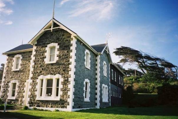
Homestead The homestead is a substantial two-storey F-plan gabled homestead with stone quoins and window surrounds. It has a corrugated iron roof with finials on the gable ends. Since its purchase by the Tautuku Fishing Club in the 1970s, there has been a two-storey addition to the rear of the homestead, and a single storey addition to the north-east elevation. These additions are not included in the registration. Outbuildings The outbuildings are a single stone building in a u-shaped plan, forming a courtyard enclosed on three sides. The cow byre/ milking shed is on east side of the complex. The long open interior has been divided into stalls. There are rail lines running down the centre of the building (a feature common to the cow byre on Mathieson's Farm Steading on nearby Centre Road). On the south side of the complex is a formerly two storey portion of the building. One end of this building was originally the men's quarters. There is a fireplace on the west wall. The roof has fallen in. On the north side of the complex closest to the cow byre is the former cart shed with arched doorways into the central courtyard. The roof has fallen in, and the ground level has risen with an accumulation of earth and other material over time. Next to the cart shed is what may have been the dairy. On the outside of the north elevation a stone and concrete addition has been added. This housed the power plant for the hydro generation system. The roof is partially collapsed and like the cart shed the ground level has risen with an accumulation of earth and other material over time. There is an assortment of other farm buildings in the vicinity. The registration includes the stone farm buildings associated with the Smaill's ownership of the property.
Homestead The homestead is a substantial two-storey F-plan gabled homestead with stone quoins and window surrounds. It has a corrugated iron roof with finials on the gable ends. Since its purchase by the Tautuku Fishing Club in the 1970s, there has been a two-storey addition to the rear of the homestead, and a single storey addition to the north-east elevation. These additions are not included in the registration. Outbuildings The outbuildings are a single stone building in a u-shaped plan, forming a courtyard enclosed on three sides. The cow byre/ milking shed is on east side of the complex. The long open interior has been divided into stalls. There are rail lines running down the centre of the building (a feature common to the cow byre on Mathieson's Farm Steading on nearby Centre Road). On the south side of the complex is a formerly two storey portion of the building. One end of this building was originally the men's quarters. There is a fireplace on the west wall. The roof has fallen in. On the north side of the complex closest to the cow byre is the former cart shed with arched doorways into the central courtyard. The roof has fallen in, and the ground level has risen with an accumulation of earth and other material over time. Next to the cart shed is what may have been the dairy. On the outside of the north elevation a stone and concrete addition has been added. This housed the power plant for the hydro generation system. The roof is partially collapsed and like the cart shed the ground level has risen with an accumulation of earth and other material over time. There is an assortment of other farm buildings in the vicinity. The registration includes the stone farm buildings associated with the Smaill's ownership of the property.
Historical and Associated Iwi / Hapū / Whānau
Information Sources
Cyclopedia of New Zealand, 1905
Cyclopedia Company, Industrial, descriptive, historical, biographical facts, figures, illustrations, Wellington, N.Z, 1897-1908, Vol. 4 Otago and Southland, Cyclopedia Company, Christchurch, 1905
Duckworth, nd
H. Duckworth, 'History of Anderson's Bay and Tomahawk' unpublished ms, NZHPT Otago/Southland Area Office Library, Dunedin
Land Information New Zealand (LINZ)
Land Information New Zealand
Otago Daily Times
Otago Daily Times, 1 Jun 1915, p.10.
Otago Witness
Otago Witness
Other Information
A fully referenced version of this report is available from the NZHPT Southern Region Office. Please note that entry on the New Zealand Heritage List/Rarangi Korero identifies only the heritage values of the property concerned, and should not be construed as advice on the state of the property, or as a comment of its soundness or safety, including in regard to earthquake risk, safety in the event of fire, or insanitary conditions.
Current Usages
Uses: Agriculture
Specific Usage: Stables
Uses: Civic Facilities
Specific Usage: Club rooms/building
Uses: Vacant
Specific Usage: Vacant
Former Usages
General Usage: Accommodation
Specific Usage: House
General Usage: Agriculture
Specific Usage: Dairy/ buttery/cheese house
General Usage: Agriculture
Specific Usage: Farm
General Usage: Agriculture
Specific Usage: Shed
General Usage: Utilities
Specific Usage: Power House
Location
Sign up to hear more
Get the latest heritage news, features and events delivered
straight to your inbox.
