

The Gardens were designed around a detached residual bend of the Maitai River known as the 'Eel Pond'. This U-shaped body of water was used for food gathering by Maori.
In 1841, when the first British immigrants arrived in the area, the land was progressively cleared of bush. In 1842 it was set aside as a meat market (abattoir) and served this and a variety of other purposes until the 1880s.
In the 1880's, the town of Nelson was well established, yet it remained one of the few towns in New Zealand that did not have a public garden. By this period the Eel Pond was considered an eyesore and in need of attention. On 22 June 1887, the area was dedicated 'the Queens Gardens' as part of the commemoration of Queen Victoria's 50th Jubilee celebrations.
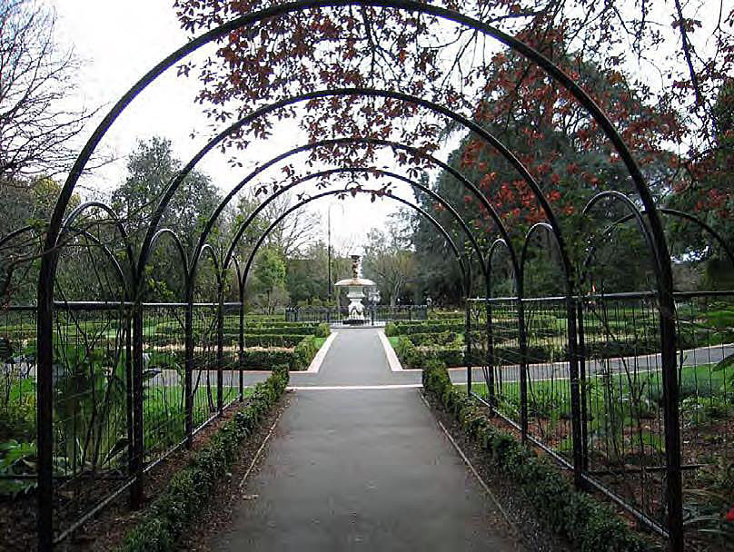
The following year a competition to design the new gardens was held, but to no effect. A second competition was won by architect Mr. Antequil F. T. Somerville, whose design retained the pond much in its existing shape, and featured a wooded, formal perimeter with avenues of trees and shrubs, and a more formal and open central axis for promenading and civic functions. Included in the design was a rustic bridge over the pond, a band rotunda and a fernery.
Work began shortly afterwards and in 1892, Nelson's 50th Jubilee year, the Gardens were formally opened. Commemorative trees were planted to recall the event and, over the next decade, the garden was developed.
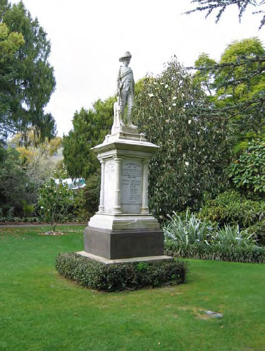
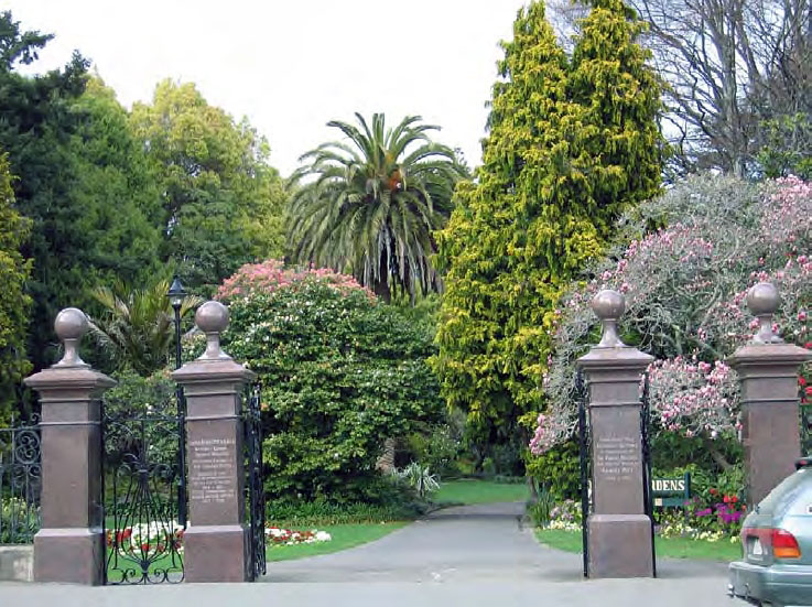
In the early twentieth century the Gardens became a repository for sculptures and garden ornaments that recognise Nelson's great and good. Most notable of these are the Boer War Memorial, and the two Memorial Gates, which commemorate Albert Pitt (1842-1906), a military man and commander of the Nelson military district between 1877 and 1899, and former mayor Francis Trask who was a driving force behind the establishment of the Gardens. The Gardens were further developed through donations and the labour of the community. The Gardens continue to be enjoyed by Nelson citizens and visitors and are now an important example of an intimate, Victorian inspired garden.
The Queens Gardens, Nelson, have significance as a reflection of the growth and development of the city, as a cleverly designed and aesthetically pleasing environment, for the diverse plant collection and role in fostering civic pride and social relaxation and enjoyment.
List Entry Information
Status
Listed
List Entry Status
Historic Place Category 2
Access
Able to Visit
List Number
7689
Date Entered
30th March 2007
Date of Effect
30th March 2007
City/District Council
Nelson City
Region
Nelson Region
Extent of List Entry
The registration includes the 1.8042 hectares of land comprised in Pt Reserve M City of Nelson (NZ Gazette 1880, p.377), Pt Sec M City of Nelson (DI NL1/674), Sec 1156, 1157 City of Nelson (RT NL72/273), Pt Secs 202 City of Nelson (RTs NL10B/664, NL12/62), Pt Sec 204 City of Nelson (RTs NL38/197, NL106/187) Nelson Land District, and the Queens Gardens, including the Eel Pond and Islands, Rose Garden, Pitt Memorial Gates, Trask Memorial Gates, Boer War Memorial, Priapos Fountain, Mill Race, tall tree framework (see 'Survey of Tall Trees, February 2005' in Appendix 5 of Registration Report), Bridge and Tasman Street Gates, stone walls and layout thereon.
Legal description
The land comprising the Queens Gardens is made up of nine parcels comprising 1.8042 hectares, as follows : Pt Reserve M City of Nelson (NZ Gazette 1880, p.377), Pt Sec M City of Nelson (DI NL1/674), Sec 1156, 1157 City of Nelson (RT NL72/273), Pt Secs 202 City of Nelson (RTs NL10B/664, NL12/62), Pt Sec 204 City of Nelson (RTs NL38/197, NL106/187) Nelson Land District.
Location Description
Queens Gardens is located to the east of 208 Bridge Street, on the corner of Tasman Street and to the north of 96 Tasman Street. It is between 337 and 353 Hardy Street, and is bounded on the west by Albion Square, the Technical School and the Bishop Suter Art Gallery.
Why is this place significant?
Cultural Significance
Social Significance or Value The Queens Gardens have social value. Designed for pleasure, the Gardens were intended to promote social interaction, relaxation and enjoyment of citizens of, and visitors to Nelson. The continued use and development over the last century indicates that the Gardens continue to fulfil this essential purpose. The Gardens today are used by adults and children, citizens and visitors. They are a social meeting place, a place for wedding photos and children's birthday parties, a space used by plant lovers, tourists, painters and tai chi enthusiasts. They are important to the people of Nelson as a fitting repository for civic and private memorials and commemorative celebrations. The people of Nelson have cared for, discussed and debated the development of the Gardens for decades, and the development of the spaces within the Gardens reflects the attachment of the communities within Nelson. Traditional Significance or Value The land on which the Queens Gardens was developed and the Eel Pond were of traditional significance to Maori as mahinga kai. The importance of the area for fishing and food gathering was partially recognised by the New Zealand Company, which set aside Sections 203 and 205, for Maori. However, by the 1850s the forest had been cleared leaving only a small clusters of trees, and the reserves were rapidly eroded; in 1844, Section 205 was given to the Nelson School Society and in 1848, the reserve status of Section 203 was also revoked. It is not known whether Maori continued eel fishing at the pond after this occurred. Efforts were made by the Council and Acclimatisation Society over the years to cull or eradicate the eels, as they were seen as predators for the ducks and swans, but the population continues to survive and thrive.
Historic Significance
Historical Significance or Value The Queens Gardens are a reflection of the growth and development of the city and its sense of civic pride. Created to ensure that Nelson kept up with other major towns and cities around New Zealand, the development of the Gardens is a result of the personal involvement and dedication of Nelson's citizens. The Gardens were conceived of by the local council, designed by Antequil F. T. Somerville, a local Nelson architect, and maintained by the Council and various community groups. Citizens of Nelson donated many of Gardens' chief ornaments, including the Trask and Pitt Memorial Gates, the Boer War Memorial and the Priapos Fountain. The Gardens also reflect the interests and attitudes of the people of Nelson over time. The late nineteenth and early twentieth century devotion to the Queen and Empire, for instance, is reflected in the name of the Gardens and the sentiments inscribed on the Boer War Memorial, while the layout and the plant collection are broadly Victorian in style, reflecting Victorian interests in science, botany and gardening and the idyllic, natural world. The Queens Gardens are therefore of historic significance in Nelson.
Physical Significance
Scientific Significance or Value The Queens Gardens have scientific value for the plant collection it contains. The collection has a diversity of flora and contains a number of trees and plantings of significance. The gardens feature both woodland and subtropical trees, with perennial woodland under-plantings including an extensive collection of native ferns, and specimen trees planted to commemorate important occasions. Of particular note is the dawn redwood (Metasequoia glyptostroboides) that was planted on a planted on Arbour Day, 1951. Planted just seven years after the species was discovered, it is now the largest tree of its kind in New Zealand. Also of note are the remaining trees planted at the opening of the Gardens on the 50th Jubliee of Nelson in 1892. Aesthetic Significance or Value The Queens Gardens have aesthetic value as a space designed to create a relaxed, pleasant atmosphere. A sense of apartness and intimacy is created in the midst of Nelson city by the enclosing, tall tree framework that blocks views of the city and the Gardens' immediate surrounds. The sounds of birdlife, rustling leaves and splashing water further blocks the outside world. Within the Gardens, several different moods or themes are created. The two main themes revolve around that of the rustic garden with a stylised woodland of tall trees, dappled light, lush undergrowth and sparkling water around the perimeter and the formal, geometric and manicured landscape created by the rose gardens, flowerbeds and promenades at the Gardens' heart. The effect is complex, the scale is intimate, and the contrast is effective, creating a succession of new experiences for visitor.
Why is this place Category 1 / Category 2?
Detail Of Assessed Criteria
(a) The extent to which the place reflects important or representative aspects of New Zealand history By the 1880s, many New Zealand towns had developed public gardens, which reflected a sense of civic pride in their new home towns and progress. A motivating force behind the establishment of the Queens Gardens in Nelson was the perception that 'In every other town in New Zealand but Nelson there was a public garden'. The Queens Gardens are therefore of some interest as a reflection of a contemporary trend. (c) The potential to provide knowledge of New Zealand history The Queens Gardens' land has potential to provide knowledge of New Zealand history. It was used by Maori for food gathering and has been in heavy and continuous use since the first European settlement of Nelson in 1842. A school, a public baths, a meat market (abattoir), stables, a pound and a flour mill all operated on or alongside the Eel Pond reserve prior to the development of the Gardens in the late nineteenth century. Clear, physical links to this early history remain in the form of the mill race linked to Nelson's first flour mill. (e) The community association with, or public esteem for, the place Community groups and individuals have displayed a strong association with the Queens Gardens since its inception. This is reflected in the use of the Gardens as a repository for memorials of importance to the community, from the Boer War Memorial (circa 1903) to the various commemorative trees planted throughout the history of the Gardens right through to the present day. The esteem in which the Gardens are held is indicated by the donation of both goods and time by various community groups. The Priapos Fountain, for instance, which is central to the Gardens' aesthetic, was donated by members of the community. Community groups are also responsible for the Rose Garden (maintained by the Nelson Rose Society) and the Fernery was maintained for many years by the Nelson Fern Society. The Gardens are well-maintained and continue to be well-used. Perceived threats to the Gardens resulted in the formation of the 'Queens Gardens Preservation Society' in 2004, further indicating the strength of community feeling for the Queens Gardens. The Queens Gardens appear, therefore, to have a place in the public's esteem. (g) The technical accomplishment or value, or design of the place The design of the Queens Gardens is of significance. The Gardens include core elements of the Victorian garden, balancing a stylised romantic 'woodland' or idyllic 'natural' world around the Eel Pond with the formal, manicured beds for promenading and civic functions at the Gardens' heart. The contrast between the two is deliberate and enhances the effect of each garden style. The design makes the most of the available space: the Queens Gardens are compact yet the density of the tall tree framework throughout disguises its boundaries and create the illusion of infinite woodland. Clever planning creates a succession of small-scaled garden rooms with each entrance opening out onto a different theme or aesthetic, which further disguises the limited space. Transition from 'room' to 'room' is smoothly handled, with the Eel Pond providing continuity and coherence. (h) The symbolic or commemorative value of the place Commemoration is central to the function and aesthetic of the Queens Gardens. The land on which the Gardens were developed was dedicated as the 'Queens Gardens' in 1887 to commemorate the Fiftieth Jubilee of Queen Victoria. The Gardens were formally opened on Nelson's Jubilee Year and immediately became repository for civic memorials; key elements in its design are shaped by them. To mark the Jubilee, the trees that now provide the tall tree framework that shapes the Gardens were planted on 1 February. The major feature of the Boer War Memorial Lawn, the Boer War Memorial, recalls the men of Nelson who lost their lives during their military service and symbolises the feelings of national pride, patriotism and loyalty to the Empire that that war aroused. The elaborate gates at the two main entrances to the Gardens commemorate former mayor Francis Trask and Albert Pitt, former commander of the Nelson military district. Many of the other trees and various features, such as the seats and the waterwheel, were installed to commemorate an event or person. Amongst these trees is the dawn redwood, planted on Arbour Day 1951, a kauri that marks the centenary of the Salvation Army, and a liriodendron planted by Queen Beatrix of the Netherlands to mark the 350th anniversary of Abel Tasman's discovery of New Zealand. The Queens Gardens therefore have commemorative value in Nelson. (k) The extent to which the place forms part of a wider historical and cultural complex or historical and cultural landscape The Gardens form part of wider historical landscapes. Remnants from early land uses remain in the form of the mill race that served as an outlet for the flour mill located where the Technical School now stands. The Gardens themselves were designed to complement the Provincial Buildings' gardens: when plans for the Gardens were being developed, it was noted that 'no better domain exists in New Zealand than could be ours by uniting the present Eel Pond reserve with the public grounds already connected with our Provincial Buildings, and beautifying them to an almost unlimited extent'. The Gardens are now visually separated from the grounds of the former Provincial Buildings by a concentrated grouping of trees; however, both gardens retain plantings from the late nineteenth century. The Gardens also complement the Bishop Suter Art Gallery, which was constructed in 1899 and designed to maximise benefit from its Garden setting. The Gallery stands on the western bank of the Eel Pond and when first constructed could be viewed from across the Eel Pond with its original entrance facing towards the Queens Gardens. The main entrance to what has become the Suter Gallery complex is now off Bridge Street, but the café area is accessed via the Gardens' woodland walk on the western edge of the Eel Pond. Summary The Queens Gardens, Nelson, are worthy of registration as a Category II historic place as a reflection of the growth and development of the city, as a cleverly designed and aesthetically pleasing environment, for its diverse plant collection and for its role in fostering civic pride and social relaxation and enjoyment.
Construction Professional
Name
Somerville, Antequil F. T.
Type
Architect
Biography
Antequil F. T. Somerville was an architect and, between 1887 and 1890, was based in Trafalgar Street North, Nelson. As well as winning the design for the Queens Gardens, Somerville entered and won a City Council competition to design a drainage scheme for Nelson. (Queens Gardens Registration Report, 30 March 2007) Somerville was an architect who was active in Nelson from the 1870s to 1890 when he left New Zealand for Australia. Somerville designed a range of commercial, ecclesiastical, public, scholastic, and residential buildings in Nelson during this period. In his role as architect for Nelson Girl's College he designed the buildings there and he was also responsible for other school buildings because he was the Town School Committee's architect. Some of his most high profile buildings and projects in Nelson remain, including the Queens Gardens, New Zealand Insurance Building, and the Garin Memorial Chapel. Somerville also entered and won a City Council competition to design a drainage scheme for Nelson. (Colonist, 10 June 1890, p.3; Queens Garden, Nelson, Category II historic place (Record number 7689); New Zealand Insurance Building, Nelson, Category II historic place (Record number 3022)
Construction Details
Start Year
1887
Type
Designed
Description
Gardens designed and reserve dedicated as the 'Queens Gardens'
Start Year
1889
Type
Original Construction
Description
Bottom and sides of Eel Pond sealed with tar and Pond filled with water in January; Forest trees planted and grass sown along the margins of the Eel Pond
Start Year
1892
Type
Other
Description
Queens Gardens formally opened on Nelson's Jubilee Year and commemorative trees planted
Start Year
1893
Type
Addition
Description
Seven garden seats added and exotic trees planted
Start Year
1895
Type
Addition
Description
Rustic bridge constructed over Eel Pond; Priapos Fountain and pool installed
Start Year
1903
startYearCirca
Type
Addition
Description
Boer War Memorial installed
Start Year
1905
Type
Addition
Description
Fernery installed
Start Year
1912
Type
Addition
Description
Pitt and Trask Memorial Gates installed
Start Year
1915
Type
Addition
Description
Turkish Pontoon installed
Start Year
1923
Type
Addition
Description
Rose Garden established
Start Year
1927
Type
Addition
Description
Rustic bridge to fernery constructed
Start Year
1929
Type
Addition
Description
First island added to Eel Pond
Start Year
1932
Type
Addition
Description
Stone wall boundary constructed
Start Year
1935
Type
Modification
Description
War trophies relocated
Start Year
1936
Type
Addition
Description
Bluestone wall constructed
Start Year
1942
Finish Year
1952
Type
Modification
Description
War trophies removed
Start Year
1986
Type
Modification
Description
Bridge replaced
Start Year
1993
Type
Addition
Description
Gazebo installed
Start Year
1998
Type
Addition
Description
'Sentinel' installed
Start Year
1999
Type
Addition
Description
Information panels added, minor changes to Rose Garden
Start Year
2002
Type
Addition
Description
Feature lighting added
Start Year
2004
Type
Addition
Description
Boardwalk added
Start Year
2005
Type
Addition
Description
Waterwheel added
Start Year
2006
Type
Modification
Description
Chinese Garden developed
Construction Materials
Pitt Memorial Gates: Granite, cast-iron, wrought-iron. Boer War Memorial: Marble, basalt and concrete. Priapus Fountain: concrete with a new painted-metal fence bent into a hooped pattern (1999) Paths: Asphalt (formal areas) and compressed earth (near the west arm of the Eel Pond).
Historical records of pre-European Nelson give detailed accounts of the sequence of Maori settlement in the area and pre-European land use. It is known that Maori had a number of sites in the area of Whakatu (now Nelson city) where they lived seasonally or on a short term basis for food harvesting. The area was not permanently inhabited between the late 1820s and 1830s and was not occupied when the New Zealand Company arrived in 1841. However, it remained an important area to Tasman Bay Maori, particularly for those living at the eastern end at Whakapuaka and other nearby settlements along the shores. The Wood, the Eel Pond and the nearby river margins and swamps were significant as food resources. The Wood was some 150 acres and extended down the north bank of the Maitai. J. D. Peart, an historian who collected oral histories from local Maori, wrote that 'The Wood was dark and dense and the home of kaka and keruru'. Lowther Broad, who wrote an history of Nelson at the end of the nineteenth century, noted that the forest trees in the Wood included maitai, pukatere, tikotea, totara, white and red pine [kahikatea and rimu]; and the forest birds included pigeon [keruru], kaka, weka, pukakai and the native rat. The Eel Pond was a traditional eel fishing and food gathering area and the surrounding swamp would have been a source of weka, native ducks and pukeko. Other Maori foods which would have been in good supply in the area were kahikatea and maitai berries, flax, honey, fern shoots and fern roots, and forest birds. Flax and raupo were also used for weaving baskets and cloth, and for making cords and bindings. In 1842, British immigrants were first brought to the Nelson area by the New Zealand Company, a private company set up to promote colonial settlement programmes. The plan was to attract settlers from all social classes; and to form, right from the start, a town with all the services and amenities, schools and administration, necessary to ensure a civilised community. By mid 1843, more than 1900 adult settlers with nearly 1400 children had arrived in Nelson. When the first expeditionary part of the New Zealand Company arrived in Nelson Whakatu in October 1841, they found a Wood of several hundred acres, alive with birds and pigs. The main part of the town site, west of the Wood, was covered in bush, fern, flax and toitoi. From the first arrival in the spring of 1841, the New Zealand Company and settlers quickly cleared and burned off the scrub and forest to obtain land for the town sections. The Wood was cut down for building timber for the settlers' first houses and for firewood. Sketches of Nelson by the first English settlers show the Wood standing, and indicate how quickly it was levelled. John Saxton, an English settler who arrived in Nelson in 1842, made a sketch in that year of the town of Nelson from the Grampians and the Valley of the Maitai. The early tent settlement is on cleared, flat ground and the great Wood is shown as an extensive cover of tall trees along the Maitai River and up the Maitai Valley. A sketch by Francis Dillon Bell, Nelson in 1845 also shows an extensive wood with permanent buildings now starting to define the town area. By the next year, when William Fox painted Nelson 1846, a watercolour from a similar point of view to Saxton's, there was only light tree cover along the Maitai River and light scrub cover in the area of the Eel Pond. Charles Heaphy's View of Nelson shows that, by the 1850s, the entire area had been cleared, with only a small group of trees on the Hardy Street side of the Eel Pond and the occasional tree on the Tasman Street side. As part of the establishment of Nelson, the British Government required that the New Zealand Company set aside specific reserves for Crown use; and for Maori ownership. The Eel Pond and its surrounding land were set aside for use as a meat market. The formal description at the time was 'Reserve H - Meat Market and the Serpentine: 4 acres 2 roods - Colonial Reserve', . However most newspaper, map and title references from the 1840s onwards refer to the pond as the 'Eel Pond'. Two adjacent sections, Sections 203 and 205, were set aside for Maori, indicating the importance of this area for fishing and food gathering purposes. In 1844, Section 205 was given to the Nelson School Society for the Matthew Campbell School. In 1848, the reserve status of Section 203 was also revoked. It is not known whether Maori continued eel fishing at the pond after this occurred. Reserve H, one of the Crown Reserves set aside in 1842, was an almost rectangular block of land extending from the Eel Pond north to Bridge Street and running from Tasman Street across to what is now the east side of Albion Square. It was the only 'meat market' reserve designated for the new town. It seems the intention was for Reserve H to be a killing area or abattoir, rather than a meat sale area. The Crown's instructions were that the meat market was to be near water, which would not have been an issue if its sole use was as a place for the sale of meat, and a separate reserve, Reserve K - a 'cattle market' had been formed for sale purposes on Waimea Road beyond Toi Toi street. In 1856, the majority of Reserve H was renamed 'Reserve M' and described as 'reserved for cattle, meat, fish and other markets'. By 1874, the north east corner of Reserve M had been renamed 'Reserve D, part of Reserve H' and had been 'set apart for a Meat Market' and vested in Nelson City Council, suggesting that the meat market was still functioning in 1874. The meat market corner appears in early photographs. There were stockyards made of timber paling fences on the corner of Tasman and Bridge Streets, and running back into the land between the two arms of the eel pond. A photograph dated between 1861 and 1880 shows the stock yards on the land between the Pond arms. Also on the Reserve during the 1870s was a house on Bridge Street, and a public pound on Tasman Street. At that time, the west arm of the pond extended almost to the centre of Bridge Street. There is no record of when the meat market moved away from the site but, in 1879, the City Council decided that the area should be a 'recreation ground', a statutory definition which included 'public gardens, parks and domains'. The Hardy Street Baths, comprising a public bathhouse and a swimming pool, were located at the Hardy Street end of the Gardens, on land set aside as Public Utility Reserve G, part of Section 202, the area now just inside the Trask Gates. Part of the Eel Pond was enclosed to form the swimming pool. They operated between 1866-1886, after which time the land was taken by Council to be part of the Gardens. In 1880, the City Council gave permission for the Bishop to erect a Sunday School Centenary Gathering Memorial on the Reserve. A photograph taken in the 1880s shows what is presumed to be the memorial, a tall, obelisk style structure in the centre of the grounds. The same photograph indicates that, by this time the Reserve had been substantially grassed but that the Eel Pond was covered with raupo and bulrush. The need for a public garden had been in the mind of progressive Nelsonians since the start of the colony. While the first settlers had been largely preoccupied with establishing essential services, they had still found time to form the Nelson Horticultural Society in 1843. The New Zealand Company had set aside land in 1842 for botanical gardens, to be located along the Maitai River between Nile Street East and Hardy Street, but that land was soon reassigned for housing. The Horticultural Society repeatedly called for the development of botanic gardens and parks over many years. By the 1880s, a number of other New Zealand towns had developed public gardens. Second generation European settlers had developed a sense of civic pride in their new home towns, and a public garden was a way to demonstrate how civilised the town had become. By 1886, Nelson was ready for its own botanic garden. At the end of 1886, the City Council decided to drain and reshape the Eel Pond and to form a public garden on the Eel Pond Reserve land. One of the councillors, Mr. Graham, hoped the work would not only 'remove an intolerable nuisance, but be the commencement of...a very beautiful garden'. The Council's goal was: The providing of recreation grounds and gardens for the pleasure of citizens and visitors to our town, for which purpose they are of opinion no better domain exists in New Zealand than could be ours by uniting the present Eel Pond reserve with the public grounds already connected with our Provincial Buildings, and beautifying them to an almost unlimited extent. Councillors envisioned that adjacent land uses would be absorbed into the new garden and that land between the new garden and the Provincial Buildings would be acquired for inclusion into the garden. The Public Works Committee recommended the Nelson School Society land (Section 205) be acquired for the Gardens. The Council adopted the report enthusiastically and unanimously. Councillor Trask was a strong supporter of the project, saying there was currently no proper garden in the town and: If they could get the small strip between the Buildings and the reserve, and in time do away with the stables and pound, and possibly get the baths and the other property, they would have a fine square which would prove a beautiful garden. In every other town in New Zealand but Nelson there was a public garden and he hoped to see one here. On 22 June 1887, as part of the town's celebrations of the 50th Jubilee of the coronation of Queen Victoria, the Mayor Charles Y. Fell, the Bishop and the townspeople gathered at the Reserve to dedicate the area as the new public gardens. Mayor Fell turned the first sod in the new gardens and named them the 'Queens Gardens', in honour of Queen Victoria. The first steps in the formation of the Queens Gardens were to plan the layout and to tidy up the Eel Pond to make it a smooth and reflective 'ornamental piece of water'. A competition was held for the design of the garden in June 1887, for a prize of £5. Five designs of 'more or less merit' were submitted but the judging panel, which included the Public Works Committee and the Bishop, found none of them 'sufficiently good'. A second competition was then advertised, emphasising the Council's requirement that the existing water area was not to be substantially reduced. While waiting for the competition entries, the City Surveyor was given permission to proceed with plans for levelling the bottom of the Eel pond and trimming its banks. At that time, the plan was for the work to the pond to be paid for by the city funds. The Surveyor's plans were completed and the work ready to be tendered by the end of August 1887. Around this time, the seven entries to the design competition were considered. The winning design was compiled by Mr. Antequil F. T. Somerville. Somerville's winning design retained the pond much in its existing shape, except to reclaim the ground at the north end of the west arm, which then extended halfway across the street. There were to be shrubs on the Bridge Street boundary. A pathway between the shrubs was to lead into the area between the two arms of the pond to a band rotunda and flower beds. Somerville's design included a rustic bridge 'across from the Pond from the western side' and walks and shrubberies. In the area where the foundations of a mill were, the ground had already been excavated and was to become a fernery. In 1887, members of the public contributed funds to reshape the pond and for planting. Turning the pond into an ornamental body of water proved more difficult than envisioned. It would not hold water and for two years it collected rubbish and was a muddy eyesore. Eventually, in January 1889, the bottom and sides were sealed with tar and the pond filled. It was noted in the Colonist that, by next season, the Gardens would be a 'pleasant resort'. Also in 1889, the central area within the arms of the Eel Pond was sown as grass and 'forest trees' were planted around the margins of the pond. The Queens Gardens were formally opened by Mayor Trask in 1891 but continued to develop over the next few years. The Gardens were managed from the outset by a caretaker, the first being Edward Christian, who was housed in the Gardens in a building completed by the Municipal Corporation in 1891. The first of the changes occurred in Nelson's Jubilee Year, 50 years after the founding of the town in 1842. To commemorate the occasion, a number of trees were planted in the Queens Gardens on 1 February 1892, solidifying the Garden's status as a place for civic memorials. In 1893 the Gardens were further improved by the addition of seven garden seats and the planting of exotic trees, such as Mt Atlas cedar, camphor, Norfolk Island pines and weeping cypress. By the late 1890s the Gardens had been planted with New Zealand natives, including nikau palms and cabbage trees, as well as flowering shrubs such as rhododendrons, azaleas, camellias and roses. Bedding chrysanthemums featured in late summer. The Acclimatisation Society had added six white swans to the Pond and the citizens of Nelson had added a pair of black swans. Native paradise ducks and wild teal were also seen on the pond on occasion. Settlers presented a pair of pheasants, a pair of weka, a kiwi and a peacock. Blackbirds were plentiful but New Zealand native birds did not favour the Gardens. A fountain and pool (1892), donated to the Gardens by Mrs Trask and others and installed on the site intended for the band rotunda, was well stocked with goldfish. A rustic fountain had been established near the Hardy Street entrance and a bridge (1895) had been constructed along the south end of the Eel Pond, which had been well stocked with trout. The Gardens had become 'a pleasant place of resort close to the city'. The Queens Gardens continued to develop. In 1905 a fernery was installed and in 1906 the Cyclopedia of New Zealand described the Gardens as being 'tastefully laid out' and 'a popular resort'. In 1912 the Trask Memorial Gates were erected at the Hardy Street entrance and the Pitt Memorial Gates were installed at the entrance off Bridge Street. In 1915 the City Council was gifted a Turkish pontoon, captured at the Battle of the Suez Canal by the 12th Nelson Company. The pontoon was subsequently installed in the Gardens. Another trophy, a World War One German field gun, was installed alongside the pontoon after 1920. Photographs from the early 1920s appear to show two cannon alongside the pontoon. One of the cannons was probably the Nelson time signal cannon gifted to the Council in 1919 by Nelson resident John Graham and originally located at Britannia Heights. In 1923 the Horticultural Society made a formal Rose Garden near the pontoon, with beds that encircled the cupid fountain and pool. In 1927 the fernery was developed with the assistance of the Horticultural Society, and the Council constructed a rustic bridge leading to it. Council minutes note ongoing work in the fernery over the next few years, including the bringing in of rocks in 1928, and the donation of ferns from a Brightwater resident in 1932. Large tree ferns already existed on the south side of the Eel Pond and so it is likely that the fernery development work was to extend and under-plant that area. Council minutes in 1927 refer to a summerhouse to be built near the fernery and the following year thanks are recorded in the minutes to the volunteers who helped with the summerhouse construction. The summerhouse was located near where the mill race from Mathew Campbell's mill entered the pond. According to local recollection, there was also a small bridge over the mill race at that point. Around 1929, work on the construction of the first of two islands in the Eel Pond commenced. The island was located at the Bridge Street end of the eastern arm of the pond. By 1931 the Council had obtained an estimate to construct a second island but did not proceed immediately. The Depression was underway and Council funds were limited. However the Nelson Fern Society undertook replanting work in the fernery, and planted new ferns on the Gallery side of the pond and under the trees on the west end of the Bridge Street boundary. In 1935, the pontoon, field gun and possibly the cannon, were relocated to the land originally used by the Mathew Campbell School, next to the Bishop Suter Memorial Art Gallery. That same year, three hotbeds and frames were installed in the Gardens, for raising seedlings for the flowerbeds. The trophies were removed altogether over the next two decades. In 1942, the field gun was disposed of. The cannon was removed in 1943 and the pontoon was relocated to the RSA Hall in 1952. Shortly afterwards, in 1953, the Council completed work on the second island in the Eel Pond, which was constructed just west of the bridge. In the 1980s and 1990s, further changes were made. The bridge across the pond was found to be rotting and was replaced in 1986 with a replica of the original. The summerhouse was removed by the early 1990s and a gazebo, which stands on the south side of the pond near the Bishop Suter Memorial Art Gallery, was completed by the Nelson Rotary Club in 1993. In 1998 an iron pond sculpture 'Sentinel' by Nelson artist Dominque de Borrekens and Grant Scott, was installed in the Eel Pond. Information panels were added in 1999 and the rose gardens were replanted. A new trellis was added to the south side of the roses, a pergola was erected over the path between the roses and the bridge and terracotta tile edging was added to the paths. In 2002 feature lighting was added and in 2005 a water wheel, which symbolises 100 years of rotary, was added near the original mill race.
Historical records of pre-European Nelson give detailed accounts of the sequence of Maori settlement in the area and pre-European land use. It is known that Maori had a number of sites in the area of Whakatu (now Nelson city) where they lived seasonally or on a short term basis for food harvesting. The area was not permanently inhabited between the late 1820s and 1830s and was not occupied when the New Zealand Company arrived in 1841. However, it remained an important area to Tasman Bay Maori, particularly for those living at the eastern end at Whakapuaka and other nearby settlements along the shores. The Wood, the Eel Pond and the nearby river margins and swamps were significant as food resources. The Wood was some 150 acres and extended down the north bank of the Maitai. J. D. Peart, an historian who collected oral histories from local Maori, wrote that 'The Wood was dark and dense and the home of kaka and keruru'. Lowther Broad, who wrote an history of Nelson at the end of the nineteenth century, noted that the forest trees in the Wood included maitai, pukatere, tikotea, totara, white and red pine [kahikatea and rimu]; and the forest birds included pigeon [keruru], kaka, weka, pukakai and the native rat. The Eel Pond was a traditional eel fishing and food gathering area and the surrounding swamp would have been a source of weka, native ducks and pukeko. Other Maori foods which would have been in good supply in the area were kahikatea and maitai berries, flax, honey, fern shoots and fern roots, and forest birds. Flax and raupo were also used for weaving baskets and cloth, and for making cords and bindings. In 1842, British immigrants were first brought to the Nelson area by the New Zealand Company, a private company set up to promote colonial settlement programmes. The plan was to attract settlers from all social classes; and to form, right from the start, a town with all the services and amenities, schools and administration, necessary to ensure a civilised community. By mid 1843, more than 1900 adult settlers with nearly 1400 children had arrived in Nelson. When the first expeditionary part of the New Zealand Company arrived in Nelson Whakatu in October 1841, they found a Wood of several hundred acres, alive with birds and pigs. The main part of the town site, west of the Wood, was covered in bush, fern, flax and toitoi. From the first arrival in the spring of 1841, the New Zealand Company and settlers quickly cleared and burned off the scrub and forest to obtain land for the town sections. The Wood was cut down for building timber for the settlers' first houses and for firewood. Sketches of Nelson by the first English settlers show the Wood standing, and indicate how quickly it was levelled. John Saxton, an English settler who arrived in Nelson in 1842, made a sketch in that year of the town of Nelson from the Grampians and the Valley of the Maitai. The early tent settlement is on cleared, flat ground and the great Wood is shown as an extensive cover of tall trees along the Maitai River and up the Maitai Valley. A sketch by Francis Dillon Bell, Nelson in 1845 also shows an extensive wood with permanent buildings now starting to define the town area. By the next year, when William Fox painted Nelson 1846, a watercolour from a similar point of view to Saxton's, there was only light tree cover along the Maitai River and light scrub cover in the area of the Eel Pond. Charles Heaphy's View of Nelson shows that, by the 1850s, the entire area had been cleared, with only a small group of trees on the Hardy Street side of the Eel Pond and the occasional tree on the Tasman Street side. As part of the establishment of Nelson, the British Government required that the New Zealand Company set aside specific reserves for Crown use; and for Maori ownership. The Eel Pond and its surrounding land were set aside for use as a meat market. The formal description at the time was 'Reserve H - Meat Market and the Serpentine: 4 acres 2 roods - Colonial Reserve', . However most newspaper, map and title references from the 1840s onwards refer to the pond as the 'Eel Pond'. Two adjacent sections, Sections 203 and 205, were set aside for Maori, indicating the importance of this area for fishing and food gathering purposes. In 1844, Section 205 was given to the Nelson School Society for the Matthew Campbell School. In 1848, the reserve status of Section 203 was also revoked. It is not known whether Maori continued eel fishing at the pond after this occurred. Reserve H, one of the Crown Reserves set aside in 1842, was an almost rectangular block of land extending from the Eel Pond north to Bridge Street and running from Tasman Street across to what is now the east side of Albion Square. It was the only 'meat market' reserve designated for the new town. It seems the intention was for Reserve H to be a killing area or abattoir, rather than a meat sale area. The Crown's instructions were that the meat market was to be near water, which would not have been an issue if its sole use was as a place for the sale of meat, and a separate reserve, Reserve K - a 'cattle market' had been formed for sale purposes on Waimea Road beyond Toi Toi street. In 1856, the majority of Reserve H was renamed 'Reserve M' and described as 'reserved for cattle, meat, fish and other markets'. By 1874, the north east corner of Reserve M had been renamed 'Reserve D, part of Reserve H' and had been 'set apart for a Meat Market' and vested in Nelson City Council, suggesting that the meat market was still functioning in 1874. The meat market corner appears in early photographs. There were stockyards made of timber paling fences on the corner of Tasman and Bridge Streets, and running back into the land between the two arms of the eel pond. A photograph dated between 1861 and 1880 shows the stock yards on the land between the Pond arms. Also on the Reserve during the 1870s was a house on Bridge Street, and a public pound on Tasman Street. At that time, the west arm of the pond extended almost to the centre of Bridge Street. There is no record of when the meat market moved away from the site but, in 1879, the City Council decided that the area should be a 'recreation ground', a statutory definition which included 'public gardens, parks and domains'. The Hardy Street Baths, comprising a public bathhouse and a swimming pool, were located at the Hardy Street end of the Gardens, on land set aside as Public Utility Reserve G, part of Section 202, the area now just inside the Trask Gates. Part of the Eel Pond was enclosed to form the swimming pool. They operated between 1866-1886, after which time the land was taken by Council to be part of the Gardens. In 1880, the City Council gave permission for the Bishop to erect a Sunday School Centenary Gathering Memorial on the Reserve. A photograph taken in the 1880s shows what is presumed to be the memorial, a tall, obelisk style structure in the centre of the grounds. The same photograph indicates that, by this time the Reserve had been substantially grassed but that the Eel Pond was covered with raupo and bulrush. The need for a public garden had been in the mind of progressive Nelsonians since the start of the colony. While the first settlers had been largely preoccupied with establishing essential services, they had still found time to form the Nelson Horticultural Society in 1843. The New Zealand Company had set aside land in 1842 for botanical gardens, to be located along the Maitai River between Nile Street East and Hardy Street, but that land was soon reassigned for housing. The Horticultural Society repeatedly called for the development of botanic gardens and parks over many years. By the 1880s, a number of other New Zealand towns had developed public gardens. Second generation European settlers had developed a sense of civic pride in their new home towns, and a public garden was a way to demonstrate how civilised the town had become. By 1886, Nelson was ready for its own botanic garden. At the end of 1886, the City Council decided to drain and reshape the Eel Pond and to form a public garden on the Eel Pond Reserve land. One of the councillors, Mr. Graham, hoped the work would not only 'remove an intolerable nuisance, but be the commencement of...a very beautiful garden'. The Council's goal was: The providing of recreation grounds and gardens for the pleasure of citizens and visitors to our town, for which purpose they are of opinion no better domain exists in New Zealand than could be ours by uniting the present Eel Pond reserve with the public grounds already connected with our Provincial Buildings, and beautifying them to an almost unlimited extent. Councillors envisioned that adjacent land uses would be absorbed into the new garden and that land between the new garden and the Provincial Buildings would be acquired for inclusion into the garden. The Public Works Committee recommended the Nelson School Society land (Section 205) be acquired for the Gardens. The Council adopted the report enthusiastically and unanimously. Councillor Trask was a strong supporter of the project, saying there was currently no proper garden in the town and: If they could get the small strip between the Buildings and the reserve, and in time do away with the stables and pound, and possibly get the baths and the other property, they would have a fine square which would prove a beautiful garden. In every other town in New Zealand but Nelson there was a public garden and he hoped to see one here. On 22 June 1887, as part of the town's celebrations of the 50th Jubilee of the coronation of Queen Victoria, the Mayor Charles Y. Fell, the Bishop and the townspeople gathered at the Reserve to dedicate the area as the new public gardens. Mayor Fell turned the first sod in the new gardens and named them the 'Queens Gardens', in honour of Queen Victoria. The first steps in the formation of the Queens Gardens were to plan the layout and to tidy up the Eel Pond to make it a smooth and reflective 'ornamental piece of water'. A competition was held for the design of the garden in June 1887, for a prize of £5. Five designs of 'more or less merit' were submitted but the judging panel, which included the Public Works Committee and the Bishop, found none of them 'sufficiently good'. A second competition was then advertised, emphasising the Council's requirement that the existing water area was not to be substantially reduced. While waiting for the competition entries, the City Surveyor was given permission to proceed with plans for levelling the bottom of the Eel pond and trimming its banks. At that time, the plan was for the work to the pond to be paid for by the city funds. The Surveyor's plans were completed and the work ready to be tendered by the end of August 1887. Around this time, the seven entries to the design competition were considered. The winning design was compiled by Mr. Antequil F. T. Somerville. Somerville's winning design retained the pond much in its existing shape, except to reclaim the ground at the north end of the west arm, which then extended halfway across the street. There were to be shrubs on the Bridge Street boundary. A pathway between the shrubs was to lead into the area between the two arms of the pond to a band rotunda and flower beds. Somerville's design included a rustic bridge 'across from the Pond from the western side' and walks and shrubberies. In the area where the foundations of a mill were, the ground had already been excavated and was to become a fernery. In 1887, members of the public contributed funds to reshape the pond and for planting. Turning the pond into an ornamental body of water proved more difficult than envisioned. It would not hold water and for two years it collected rubbish and was a muddy eyesore. Eventually, in January 1889, the bottom and sides were sealed with tar and the pond filled. It was noted in the Colonist that, by next season, the Gardens would be a 'pleasant resort'. Also in 1889, the central area within the arms of the Eel Pond was sown as grass and 'forest trees' were planted around the margins of the pond. The Queens Gardens were formally opened by Mayor Trask in 1891 but continued to develop over the next few years. The Gardens were managed from the outset by a caretaker, the first being Edward Christian, who was housed in the Gardens in a building completed by the Municipal Corporation in 1891. The first of the changes occurred in Nelson's Jubilee Year, 50 years after the founding of the town in 1842. To commemorate the occasion, a number of trees were planted in the Queens Gardens on 1 February 1892, solidifying the Garden's status as a place for civic memorials. In 1893 the Gardens were further improved by the addition of seven garden seats and the planting of exotic trees, such as Mt Atlas cedar, camphor, Norfolk Island pines and weeping cypress. By the late 1890s the Gardens had been planted with New Zealand natives, including nikau palms and cabbage trees, as well as flowering shrubs such as rhododendrons, azaleas, camellias and roses. Bedding chrysanthemums featured in late summer. The Acclimatisation Society had added six white swans to the Pond and the citizens of Nelson had added a pair of black swans. Native paradise ducks and wild teal were also seen on the pond on occasion. Settlers presented a pair of pheasants, a pair of weka, a kiwi and a peacock. Blackbirds were plentiful but New Zealand native birds did not favour the Gardens. A fountain and pool (1892), donated to the Gardens by Mrs Trask and others and installed on the site intended for the band rotunda, was well stocked with goldfish. A rustic fountain had been established near the Hardy Street entrance and a bridge (1895) had been constructed along the south end of the Eel Pond, which had been well stocked with trout. The Gardens had become 'a pleasant place of resort close to the city'. The Queens Gardens continued to develop. In 1905 a fernery was installed and in 1906 the Cyclopedia of New Zealand described the Gardens as being 'tastefully laid out' and 'a popular resort'. In 1912 the Trask Memorial Gates were erected at the Hardy Street entrance and the Pitt Memorial Gates were installed at the entrance off Bridge Street. In 1915 the City Council was gifted a Turkish pontoon, captured at the Battle of the Suez Canal by the 12th Nelson Company. The pontoon was subsequently installed in the Gardens. Another trophy, a World War One German field gun, was installed alongside the pontoon after 1920. Photographs from the early 1920s appear to show two cannon alongside the pontoon. One of the cannons was probably the Nelson time signal cannon gifted to the Council in 1919 by Nelson resident John Graham and originally located at Britannia Heights. In 1923 the Horticultural Society made a formal Rose Garden near the pontoon, with beds that encircled the cupid fountain and pool. In 1927 the fernery was developed with the assistance of the Horticultural Society, and the Council constructed a rustic bridge leading to it. Council minutes note ongoing work in the fernery over the next few years, including the bringing in of rocks in 1928, and the donation of ferns from a Brightwater resident in 1932. Large tree ferns already existed on the south side of the Eel Pond and so it is likely that the fernery development work was to extend and under-plant that area. Council minutes in 1927 refer to a summerhouse to be built near the fernery and the following year thanks are recorded in the minutes to the volunteers who helped with the summerhouse construction. The summerhouse was located near where the mill race from Mathew Campbell's mill entered the pond. According to local recollection, there was also a small bridge over the mill race at that point. Around 1929, work on the construction of the first of two islands in the Eel Pond commenced. The island was located at the Bridge Street end of the eastern arm of the pond. By 1931 the Council had obtained an estimate to construct a second island but did not proceed immediately. The Depression was underway and Council funds were limited. However the Nelson Fern Society undertook replanting work in the fernery, and planted new ferns on the Gallery side of the pond and under the trees on the west end of the Bridge Street boundary. In 1935, the pontoon, field gun and possibly the cannon, were relocated to the land originally used by the Mathew Campbell School, next to the Bishop Suter Memorial Art Gallery. That same year, three hotbeds and frames were installed in the Gardens, for raising seedlings for the flowerbeds. The trophies were removed altogether over the next two decades. In 1942, the field gun was disposed of. The cannon was removed in 1943 and the pontoon was relocated to the RSA Hall in 1952. Shortly afterwards, in 1953, the Council completed work on the second island in the Eel Pond, which was constructed just west of the bridge. In the 1980s and 1990s, further changes were made. The bridge across the pond was found to be rotting and was replaced in 1986 with a replica of the original. The summerhouse was removed by the early 1990s and a gazebo, which stands on the south side of the pond near the Bishop Suter Memorial Art Gallery, was completed by the Nelson Rotary Club in 1993. In 1998 an iron pond sculpture 'Sentinel' by Nelson artist Dominque de Borrekens and Grant Scott, was installed in the Eel Pond. Information panels were added in 1999 and the rose gardens were replanted. A new trellis was added to the south side of the roses, a pergola was erected over the path between the roses and the bridge and terracotta tile edging was added to the paths. In 2002 feature lighting was added and in 2005 a water wheel, which symbolises 100 years of rotary, was added near the original mill race.
Location The Queens Gardens are located to the east of the Nelson city centre on a block of land 1.8042 hectares (4.46 acres) in size. The original, rectangular block is bounded by Bridge Street in the north, Tasman Street to the east and Hardy Street to the south. To the west is a concentrated grouping of established trees that marks the boundary between the Gardens and Albion Square, the former location of Nelson's Provincial Government Buildings and current government administration centre. The north-west corner of the block is occupied by the Bishop Suter Art Gallery, which was originally opened in 1899. The building, which has been extended considerably, was designed to appear as part of the Gardens. The Gallery theatre provides toilet facilities to Queens Gardens' visitors, while the Gallery café is accessed via a small tree-lined path on the edge of Gardens' boundary. The south-east corner of the block is marked off by residential housing, while the south-west corner is occupied by two-storey polytechnic school and outbuildings. The remaining land is defined by a detached residual bend of the Maitai River known as the 'Eel Pond'. This body of water is U-shaped, with the arms of the U running along the north-south axis. The base of the U is at the south end of the Gardens near the Hardy Street boundary. The east arm is nearest Tasman Street, and the west arm is adjacent to the Bishop Suter Art Gallery. The Pond is fed by the remains of a mill race near the Hardy Street corner and drains into the Maitai River via outlets at the northern ends of each arm. Layout The Queens Gardens are compact yet the density of the tall tree framework throughout disguises its boundaries. These trees, planted around 1892, provide the structure that defines the spaces and vistas throughout the Gardens and creates the illusion of infinite woodland. A sense of richness, complexity and multiple experiences is created as the paths and vistas change frequently, opening onto a succession of small-scaled garden rooms. Continuity and coherence is provided by the Eel Pond that winds around the Gardens. The Queens Gardens demonstrate key elements of the Victorian garden, balancing the stylised romantic woodland around the Eel Pond with the formal, manicured beds at the Gardens' heart. Analysis of the early tall tree plantings suggests the original garden design was for a wooded, formal perimeter with avenues of trees and shrubs, and a more formal and open central axis for promenading and civic functions. Trees selected for the formal, central area were mostly evergreens and conifers, creating a year-round structural framework. Deciduous trees were kept to the less formal areas around the perimeter. Each of the Gardens' entrances opens onto a different aesthetic. The two main paths through the Gardens lead from the Bridge Street and Hardy Street entrances in toward the Rose Garden. Secondary paths run around the inside curve of the Eel Pond, around the western edge of the Eel Pond, and between the Pitt Gates on Bridge Street and the Gates on the corner of Tasman Street. From the Bridge Street Entrance The main entrance to the Gardens is off Bridge Street, via the Pitt Memorial Gates (1912). These Gates commemorate Albert Pitt (1842-1906), a military man and commander of the Nelson military district between 1877 and 1899. They create a formal entry to the Gardens and set the scene for the militaristic character of the garden immediately beyond. The Gates consist of four polished granite pillars with double gates in the centre and single, pedestrian gates on either side. The granite pillars are monumental and decorative. They stand approximately 3.2 metres high, are reddish-brown in colour, and feature decorative bases and caps. Prominent inscriptions in gold are featured on the Bridge Street side. The four gates are of high quality cast and wrought-iron, and feature scrolled flower and leaf forms. Two Phoenix palms, planted in 1892, stand at either side of the gates and formal lawns and flower beds hug the path immediately beyond the Pitt Memorial Gates. The path, surround by tall, established trees, then branches off to the east and west, while the main route curves along to the south-west. Amongst these trees is a silk tree, planted to commemorate the first international diabetes day on 27 June 1991, and a liriodendron, planted by Queen Beatrix of the Netherlands on 19 March 1992 to mark the 350th anniversary of Abel Tasman's discovery of New Zealand. The eastern pathway leads past shrubberies and flowerbeds out towards the Tasman Street entrance beyond the eastern arm of the pond. The western pathway leads to a walk that runs the length of the eastern edge of the western arm of the Eel Pond. The walk features clear views across the Pond. This arm of the pond includes a water spout (1990s) that assists the aeration of the water and adds movement and sound to the pond. A sculpture 'Sentinel' (1998) is also a feature of this part of the waterway and consists of an iron ship, left to rust naturally. The walk leads out towards the formal centre of the garden. Boer War Memorial Lawn The south-west path beyond the Pitt Memorial Gates leads to the Boer War Memorial Lawn. The Lawn is located on the eastern side of the path. To the west of the path and to the east of the Lawn are screens of tall trees that block the view of the two arms of the Eel Pond. One of these trees, a magnolia, commemorates Sir Paul Reeves, who visited the garden on 14 August 1986. The focal point of this formal, open lawn area is a memorial to soldiers killed in the Boer War (1899-1902). Designed in the Classical Revival style, the memorial features a marble statue of a soldier standing on a pedestal. The soldier is at ease, though watchful. The memorial is approximately 4.87 metres (16 feet) high and the overall composition is well balanced and competently designed, with the comparative scales of the figure and the base in harmony. Commemorative inscriptions on the pedestal list the names of the dead and text that reflects sentiments of pride in the nation and British Empire. Rose Garden Beyond the Boer Memorial Lawn the path leads to the formal Rose Garden (1923). The path to the Rose Garden is cranked, which prevents the visitor from immediately seeing the Rose Garden from the Lawn. The Rose Garden is located at the centre of the Queens Gardens at the conjunction of the two main pathways, which lead from the Bridge and Hardy Street entrances. The centre-point is marked by the Priapos or Cupid Fountain (1892), which can be seen from various parts of the Gardens. The fountain consists of a round concrete pool 3.2 metres in diameter. At the centre of the pool is 'Priapos', a concrete statue produced from a mould that depicts a boy standing on an urn balanced on a square plinth. The boy holds a fish in both hands, and his right hand is raised above his head. Water splashes into the pool from a water bowl balanced on his head. Radiating out from the fountain are two concentric, circular beds of roses. The beds are lined with low hedges of clipped box. Asphalt paths ring the beds and lead in towards the fountain, while five park benches on the outer ring path provide a place to contemplate the view. Originally, the military theme set by the Pitt Gates was continued with a collection of war trophies displayed to the south-west of the Rose Garden. These trophies have since been removed and replaced with lawn. The second prominent entrance into the Gardens is off Hardy Street, at the opposite end of the Gardens. The walk through the Gardens from this entrance is markedly different from the formal, militaristic experience that greets visitors entering from Bridge Street. However, like the Bridge Street entrance, this entrance is also marked by formal gates: the Trask Memorial Gates (1912). These Gates commemorate Francis Trask (1814-1910) who, together with his wife Emily, is credited with the establishment of the Queens Gardens. The Trask Gates are simple but ornamental in style. They consist of two, unpolished granite pillars with simple arrassed bases and caps. Each pillar features a marble plaque with metal inscriptions and stands 3.5 metres high. The simplicity of the pillars, which stand approximately 2.65 metres apart, acts as an effective contrast to the elaborate ironwork of the gates and the finials on top of each pillar. The ironwork is restrained and formal, featuring flower and leaf scrollwork in a geometric pattern. The two gates are topped by a decorative pediment that features the original crest of the Nelson City Council: a four-mast sailing ship on the sea, with a border formed by a buckled belt. The crest is approximately 400 millimetres in width and features the inscription 'Palmam Qui Meruit Ferat', which was the motto of Lord Nelson, after whom the city was named. The garden beyond the Trask Memorial Gates is defined by the base of the U-shaped Eel Pond; a calm, ornamental body of water that curves gently away from the entrance. The closely spaced, established trees and the use of ferns and shrubs create a woodland effect, and trail over and into the Pond. The effect is rustic in style, deliberately contrasting with the formal walk from the Pitt Gates. The rustic style had its roots in the early nineteenth century Romantic landscape tradition. By late Victorian times, rustic woodwork was particularly popular and considered excellent taste. The Gardens open out into an open area flanked by established trees and densely planted shrubs. At the centre of this area is feature brick paving installed in 1995 to mark the original location of the rockery and rustic fountain known as Hardy Street Fountain (1897). To the east is an area once referred to as 'Miss Green's Garden', a curved lawn area with a boundary of tall, established trees. The lawn features a dawn redwood (Metasequoia glyptostroboides), a species discovered in 1944. It was planted on Arbour Day, 1951, and is the largest tree of its kind in New Zealand. The lawn also includes a kauri, planted in 1984 to mark the centenary of the Salvation Army. To the west, a lesser path leads the visitor through a leafy, rustic woodland. This part of the garden runs along the length of the western edge of the western arm of the Eel Pond. The narrow pathway is not paved, adding to the natural feel of this part of the garden, and is dominated by tall, established trees and the presence of the waterway. A collection of New Zealand natives are a feature of the planting. Partway along the walk, are the remains of a mill race; the remnants of the outfall channel from the water-driven Campbell Flour Mill (first established in1844) and formerly located on Hardy Street. Fed by a brook that runs along Alton Street, the mill race appears in the Queens Gardens as a stream running in a bed of river stones, passing under a small bridge before entering the Eel Pond. A decorative, timber water-wheel (2005) near the end of the mill-race marks the centenary of Rotary International. The mill race is surrounded by woodland and a fernery (1905) with well-established tree-ferns. Along the walk is a timber gazebo (1993) overlooking the water. Further along, the path branches off and rises, leading visitors through a break in the trees to Albion Square. Alternatively, the route takes visitors along the leafy walk, past the Bishop Suter Art Gallery and out onto a small opening on Bridge Street. In accordance with Sommerville's designs the main pathway leads to the bridge over the Eel Pond. In accordance with Somerville's design, a rustic timber bridge arches gently over the Eel Pond, harmonising with the romantic woodland shrubs nearby. The current bridge (1986) is a replica of the original (1895) and serves to link the two sides of the Gardens. The bridge is a simple arch, with three sections. The two outside sections slope upwards to the central, flat portion. Crossed timbers brace the balustrade posts. The bridge is supported on two groups of two square piles on central concrete plinths braced with steel rods. The decking today is treated timber with chicken mesh to stop slipping. The deck structure is covered along each side by a facing board. From the centre of the Bridge there is a clear view of the Eel Pond, a sparkling avenue of water lined by tall trees. The Eel Pond, levelled in 1887 and lined with tar is 1889, retains the concrete kerb installed in by 1908. Despite this, the dense plantings make it appears natural in this part of the garden. Close by the bridge, to the south-west is an island (1953) featuring a well-established tree and other plantings. The water is populated by eels, ducks and a swan, providing a live, moving dimension to the garden landscape. On the other side of the Bridge, the path leads to the formal Rose Garden area to the north, and a sub-tropical woodland walk, along past the end of the eastern arm of the pond and out onto Tasman Street. This end of the pond is shaded and features an island (1929) that serves as a safe nesting area for birdlife. The eastern end of the pond is to feature a commemorative Chinese Garden.
Location The Queens Gardens are located to the east of the Nelson city centre on a block of land 1.8042 hectares (4.46 acres) in size. The original, rectangular block is bounded by Bridge Street in the north, Tasman Street to the east and Hardy Street to the south. To the west is a concentrated grouping of established trees that marks the boundary between the Gardens and Albion Square, the former location of Nelson's Provincial Government Buildings and current government administration centre. The north-west corner of the block is occupied by the Bishop Suter Art Gallery, which was originally opened in 1899. The building, which has been extended considerably, was designed to appear as part of the Gardens. The Gallery theatre provides toilet facilities to Queens Gardens' visitors, while the Gallery café is accessed via a small tree-lined path on the edge of Gardens' boundary. The south-east corner of the block is marked off by residential housing, while the south-west corner is occupied by two-storey polytechnic school and outbuildings. The remaining land is defined by a detached residual bend of the Maitai River known as the 'Eel Pond'. This body of water is U-shaped, with the arms of the U running along the north-south axis. The base of the U is at the south end of the Gardens near the Hardy Street boundary. The east arm is nearest Tasman Street, and the west arm is adjacent to the Bishop Suter Art Gallery. The Pond is fed by the remains of a mill race near the Hardy Street corner and drains into the Maitai River via outlets at the northern ends of each arm. Layout The Queens Gardens are compact yet the density of the tall tree framework throughout disguises its boundaries. These trees, planted around 1892, provide the structure that defines the spaces and vistas throughout the Gardens and creates the illusion of infinite woodland. A sense of richness, complexity and multiple experiences is created as the paths and vistas change frequently, opening onto a succession of small-scaled garden rooms. Continuity and coherence is provided by the Eel Pond that winds around the Gardens. The Queens Gardens demonstrate key elements of the Victorian garden, balancing the stylised romantic woodland around the Eel Pond with the formal, manicured beds at the Gardens' heart. Analysis of the early tall tree plantings suggests the original garden design was for a wooded, formal perimeter with avenues of trees and shrubs, and a more formal and open central axis for promenading and civic functions. Trees selected for the formal, central area were mostly evergreens and conifers, creating a year-round structural framework. Deciduous trees were kept to the less formal areas around the perimeter. Each of the Gardens' entrances opens onto a different aesthetic. The two main paths through the Gardens lead from the Bridge Street and Hardy Street entrances in toward the Rose Garden. Secondary paths run around the inside curve of the Eel Pond, around the western edge of the Eel Pond, and between the Pitt Gates on Bridge Street and the Gates on the corner of Tasman Street. From the Bridge Street Entrance The main entrance to the Gardens is off Bridge Street, via the Pitt Memorial Gates (1912). These Gates commemorate Albert Pitt (1842-1906), a military man and commander of the Nelson military district between 1877 and 1899. They create a formal entry to the Gardens and set the scene for the militaristic character of the garden immediately beyond. The Gates consist of four polished granite pillars with double gates in the centre and single, pedestrian gates on either side. The granite pillars are monumental and decorative. They stand approximately 3.2 metres high, are reddish-brown in colour, and feature decorative bases and caps. Prominent inscriptions in gold are featured on the Bridge Street side. The four gates are of high quality cast and wrought-iron, and feature scrolled flower and leaf forms. Two Phoenix palms, planted in 1892, stand at either side of the gates and formal lawns and flower beds hug the path immediately beyond the Pitt Memorial Gates. The path, surround by tall, established trees, then branches off to the east and west, while the main route curves along to the south-west. Amongst these trees is a silk tree, planted to commemorate the first international diabetes day on 27 June 1991, and a liriodendron, planted by Queen Beatrix of the Netherlands on 19 March 1992 to mark the 350th anniversary of Abel Tasman's discovery of New Zealand. The eastern pathway leads past shrubberies and flowerbeds out towards the Tasman Street entrance beyond the eastern arm of the pond. The western pathway leads to a walk that runs the length of the eastern edge of the western arm of the Eel Pond. The walk features clear views across the Pond. This arm of the pond includes a water spout (1990s) that assists the aeration of the water and adds movement and sound to the pond. A sculpture 'Sentinel' (1998) is also a feature of this part of the waterway and consists of an iron ship, left to rust naturally. The walk leads out towards the formal centre of the garden. Boer War Memorial Lawn The south-west path beyond the Pitt Memorial Gates leads to the Boer War Memorial Lawn. The Lawn is located on the eastern side of the path. To the west of the path and to the east of the Lawn are screens of tall trees that block the view of the two arms of the Eel Pond. One of these trees, a magnolia, commemorates Sir Paul Reeves, who visited the garden on 14 August 1986. The focal point of this formal, open lawn area is a memorial to soldiers killed in the Boer War (1899-1902). Designed in the Classical Revival style, the memorial features a marble statue of a soldier standing on a pedestal. The soldier is at ease, though watchful. The memorial is approximately 4.87 metres (16 feet) high and the overall composition is well balanced and competently designed, with the comparative scales of the figure and the base in harmony. Commemorative inscriptions on the pedestal list the names of the dead and text that reflects sentiments of pride in the nation and British Empire. Rose Garden Beyond the Boer Memorial Lawn the path leads to the formal Rose Garden (1923). The path to the Rose Garden is cranked, which prevents the visitor from immediately seeing the Rose Garden from the Lawn. The Rose Garden is located at the centre of the Queens Gardens at the conjunction of the two main pathways, which lead from the Bridge and Hardy Street entrances. The centre-point is marked by the Priapos or Cupid Fountain (1892), which can be seen from various parts of the Gardens. The fountain consists of a round concrete pool 3.2 metres in diameter. At the centre of the pool is 'Priapos', a concrete statue produced from a mould that depicts a boy standing on an urn balanced on a square plinth. The boy holds a fish in both hands, and his right hand is raised above his head. Water splashes into the pool from a water bowl balanced on his head. Radiating out from the fountain are two concentric, circular beds of roses. The beds are lined with low hedges of clipped box. Asphalt paths ring the beds and lead in towards the fountain, while five park benches on the outer ring path provide a place to contemplate the view. Originally, the military theme set by the Pitt Gates was continued with a collection of war trophies displayed to the south-west of the Rose Garden. These trophies have since been removed and replaced with lawn. The second prominent entrance into the Gardens is off Hardy Street, at the opposite end of the Gardens. The walk through the Gardens from this entrance is markedly different from the formal, militaristic experience that greets visitors entering from Bridge Street. However, like the Bridge Street entrance, this entrance is also marked by formal gates: the Trask Memorial Gates (1912). These Gates commemorate Francis Trask (1814-1910) who, together with his wife Emily, is credited with the establishment of the Queens Gardens. The Trask Gates are simple but ornamental in style. They consist of two, unpolished granite pillars with simple arrassed bases and caps. Each pillar features a marble plaque with metal inscriptions and stands 3.5 metres high. The simplicity of the pillars, which stand approximately 2.65 metres apart, acts as an effective contrast to the elaborate ironwork of the gates and the finials on top of each pillar. The ironwork is restrained and formal, featuring flower and leaf scrollwork in a geometric pattern. The two gates are topped by a decorative pediment that features the original crest of the Nelson City Council: a four-mast sailing ship on the sea, with a border formed by a buckled belt. The crest is approximately 400 millimetres in width and features the inscription 'Palmam Qui Meruit Ferat', which was the motto of Lord Nelson, after whom the city was named. The garden beyond the Trask Memorial Gates is defined by the base of the U-shaped Eel Pond; a calm, ornamental body of water that curves gently away from the entrance. The closely spaced, established trees and the use of ferns and shrubs create a woodland effect, and trail over and into the Pond. The effect is rustic in style, deliberately contrasting with the formal walk from the Pitt Gates. The rustic style had its roots in the early nineteenth century Romantic landscape tradition. By late Victorian times, rustic woodwork was particularly popular and considered excellent taste. The Gardens open out into an open area flanked by established trees and densely planted shrubs. At the centre of this area is feature brick paving installed in 1995 to mark the original location of the rockery and rustic fountain known as Hardy Street Fountain (1897). To the east is an area once referred to as 'Miss Green's Garden', a curved lawn area with a boundary of tall, established trees. The lawn features a dawn redwood (Metasequoia glyptostroboides), a species discovered in 1944. It was planted on Arbour Day, 1951, and is the largest tree of its kind in New Zealand. The lawn also includes a kauri, planted in 1984 to mark the centenary of the Salvation Army. To the west, a lesser path leads the visitor through a leafy, rustic woodland. This part of the garden runs along the length of the western edge of the western arm of the Eel Pond. The narrow pathway is not paved, adding to the natural feel of this part of the garden, and is dominated by tall, established trees and the presence of the waterway. A collection of New Zealand natives are a feature of the planting. Partway along the walk, are the remains of a mill race; the remnants of the outfall channel from the water-driven Campbell Flour Mill (first established in1844) and formerly located on Hardy Street. Fed by a brook that runs along Alton Street, the mill race appears in the Queens Gardens as a stream running in a bed of river stones, passing under a small bridge before entering the Eel Pond. A decorative, timber water-wheel (2005) near the end of the mill-race marks the centenary of Rotary International. The mill race is surrounded by woodland and a fernery (1905) with well-established tree-ferns. Along the walk is a timber gazebo (1993) overlooking the water. Further along, the path branches off and rises, leading visitors through a break in the trees to Albion Square. Alternatively, the route takes visitors along the leafy walk, past the Bishop Suter Art Gallery and out onto a small opening on Bridge Street. In accordance with Sommerville's designs the main pathway leads to the bridge over the Eel Pond. In accordance with Somerville's design, a rustic timber bridge arches gently over the Eel Pond, harmonising with the romantic woodland shrubs nearby. The current bridge (1986) is a replica of the original (1895) and serves to link the two sides of the Gardens. The bridge is a simple arch, with three sections. The two outside sections slope upwards to the central, flat portion. Crossed timbers brace the balustrade posts. The bridge is supported on two groups of two square piles on central concrete plinths braced with steel rods. The decking today is treated timber with chicken mesh to stop slipping. The deck structure is covered along each side by a facing board. From the centre of the Bridge there is a clear view of the Eel Pond, a sparkling avenue of water lined by tall trees. The Eel Pond, levelled in 1887 and lined with tar is 1889, retains the concrete kerb installed in by 1908. Despite this, the dense plantings make it appears natural in this part of the garden. Close by the bridge, to the south-west is an island (1953) featuring a well-established tree and other plantings. The water is populated by eels, ducks and a swan, providing a live, moving dimension to the garden landscape. On the other side of the Bridge, the path leads to the formal Rose Garden area to the north, and a sub-tropical woodland walk, along past the end of the eastern arm of the pond and out onto Tasman Street. This end of the pond is shaded and features an island (1929) that serves as a safe nesting area for birdlife. The eastern end of the pond is to feature a commemorative Chinese Garden.
Historical and Associated Iwi / Hapū / Whānau
Completion Date
28th February 2007
Report Written By
Rebecca O'Brien; research by Ellen Brinkman
Information Sources
Allan, 1965
R. M. Allan, Nelson - A History of Early Settlement, Wellington, 1965
Bradbury, 1995
M Bradbury (ed.), A History of the Garden in New Zealand, Auckland, 1995
Broad, 1892 (1976)
L. Broad, 'Jubilee History of Nelson', Nelson, 1892 (reprinted by Capper Press, Christchurch1976)
Field, 1942
A N Field, Nelson Province 1642-1842, Nelson, 1942
Jellicoe, 1930
RL Jellicoe, The New Zealand Company's Native Reserves, Wellington, 1930
McAloon, 1997
Jim McAloon, Nelson: A Regional History, Whatamango Bay, 1997
Mitchell, 2004
J and H Mitchell, Te Tau Ihu o te Waka - A History of Maori of Marlborough and Nelson, Wellington, 2004
Peart, 1998
J D Peart, Old Tasman Bay, Christchurch, 1998
Tritenbach, 1987
P. Tritenbach, Botanic Gardens and Parks in New Zealand, Auckland, 1987
Nelson City Council
Nelson City Council
Other Information
A fully referenced registration report is available from the NZHPT Central Region office Please note that entry on the New Zealand Heritage List/Rarangi Korero identifies only the heritage values of the property concerned, and should not be construed as advice on the state of the property, or as a comment of its soundness or safety, including in regard to earthquake risk, safety in the event of fire, or insanitary conditions.
Current Usages
Uses: Civic Facilities
Specific Usage: Fountain
Uses: Civic Facilities
Specific Usage: Garden - public
Uses: Civic Facilities
Specific Usage: Lake/Pond
Uses: Commemoration
Specific Usage: Memorial - South African War
Former Usages
General Usage: Civic Facilities
Specific Usage: Fountain
General Usage: Civic Facilities
Specific Usage: Garden - public
General Usage: Civic Facilities
Specific Usage: Lake/Pond
General Usage: Commemoration
Specific Usage: Memorial - South African War
Themes
War Memorial
Of Significance to Maori
Location
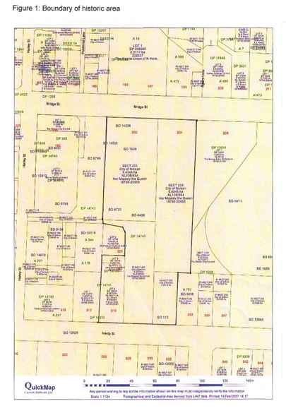
Sign up to hear more
Get the latest heritage news, features and events delivered
straight to your inbox.
