

In 1842 representations from the Anglican and Catholic authorities, in particular, led to the creation of an enlarged cemetery of 7.5 hectares (18½ acres). This was divided into four separate parts according to religious denomination to form Jewish, Catholic, and Anglican burial grounds, and a shared Wesleyan, Presbyterian and General graveyard for low-church Protestant faiths and others. These were laid out on either side of a major route south of Auckland, now known as Symonds Street. The Anglican graveyard incorporated the earlier cemetery, which led to fierce debate at the time. The size of each group's allocation was based on a government census which, among other things, determined the number of adherents to each faith. By 1852, the cemetery was further reorganised to include a separate section for Presbyterians on the site of the previous Wesleyan, Presbyterian and General cemetery. A new Wesleyan and General cemetery was added to the northern end of the Anglican graveyard.
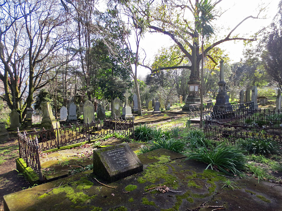
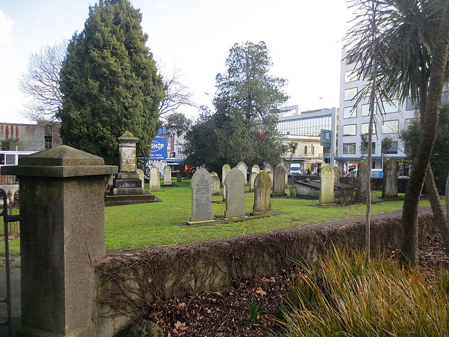
Major changes occurred through the 1860s and 1870s, when ideas about cemeteries as places of moral contemplation and edification led to a general beautification of the burial grounds. Trees were planted and paths were laid out. Monuments also often became more elaborate. Burials were subsequently restricted due to overcrowding but the cemetery remained Auckland's main burial ground until a new cemetery was established at Waikumete in 1886. The Symonds Street Cemetery was subsequently taken over as a public reserve and was simultaneously modified with the construction of public amenities, such as Grafton Bridge - the largest single-span reinforced concrete structure in the world when built - and other facilities. In the 1960s, approximately a quarter of the cemetery was destroyed during the construction of the Southern Motorway.
The remaining cemetery still encompasses approximately 5.8 hectares (over 14 acres), and is visually distinctive for including a wooded and green space in the city centre. It can be estimated to contain the burials of some 10,000 or more individuals, less than a quarter of which may be marked by surviving monuments. A great variety of people of differing age, sex, class, ethnic background and religious faith were buried in the cemetery, including some Maori. Surviving monuments reflect some of this diversity in their form and inscriptions.
Prominent individuals laid to rest in the cemetery include New Zealand's first colonial Governor, William Hobson (1783-1842), who was responsible for the signing of the Treaty of Waitangi in 1840, missionaries such as the Reverend John Hobbs (1800-1883), and early traders such as Frederick Maning (1811/1812?-1883) author of Old New Zealand. Significant events commemorated by burials include the sinking of the HMS Orpheus in 1863, New Zealand's worst maritime disaster, and the battle of Rangiriri in the third New Zealand - or Waikato - War (1863-4). The cemetery still contains many of the trees planted during beautification, which themselves had symbolic meaning. The cemetery remains an outstandingly important repository of information about colonial New Zealand and New Zealanders, and is still used for commemorative events, heritage walks and wedding ceremonies.
List Entry Information
Status
Listed
List Entry Status
Historic Place Category 1
Access
Able to Visit
List Number
7753
Date Entered
27th June 2008
Date of Effect
27th June 2008
City/District Council
Auckland Council
Region
Auckland Council
Extent of List Entry
Extent includes the land described as Pt Lots 1 & 2 DP 18958 (NZ Gazette 1994, p.2588), Pts Lot 2 DP 18958 (NZ Gazette 1990, pp.2010 & 2989, and NZ Gazette 2005, p.1806), part of Symonds Street road reserve, and Lot 2 DP 27745 (RT NA719/204), North Auckland Land District, and the structures associated with the Symonds Street Cemetery thereon, and its fittings and fixtures. (Refer to map in Appendix 1 of the Registration Report for further information). The registration includes the land and carriageways of Symonds Street and the motorway on-ramp, the wall structures on either side of Symonds Street including that between the east side of the street and the motorway on-ramp, and the Centennial Memorial Chapel and Mortuary. The registration excludes the land and structures occupied by Grafton Bridge (including its piers, eastern abutment and two sets of entrance steps to the cemetery) and the Bus Shelter and Toilets building on Symonds Street, as both have been separately registered by the NZHPT.
Legal description
Pt Lots 1 & 2 DP 18958 (NZ Gazette 1994, p.2588), Pts Lot 2 DP 18958 (NZ Gazette 1990, pp.2010 & 2989, and NZ Gazette 2005, p.1806), part of Symonds Street road reserve, and Lot 2 DP 27745 (RT NA719/204), North Auckland Land District
Why is this place significant?
Cultural Significance
Cultural Significance or Value: The Symonds Street Cemetery has cultural value for reflecting past religious, national and other identities. It also demonstrates important cultural practices, including burial, cremation and commemoration of the dead. More specific practices such as burial in extended or nuclear family groups are represented. Social Significance or Value: The Symonds Street Cemetery has social significance as a place of community gathering and commemoration for more than one and half centuries. An integral part of community life for at least its first 50 years, it continues to be used for ceremonies, commemorations and other events that reflect communal connections with forebears and other members of earlier Auckland society. It is significant for its connections with many different social classes and other groups. Spiritual Significance or Value: The Symonds Street Cemetery is of potentially high spiritual value for its close links with religious observance, the passing of life and ongoing remembrance. Parts of the place have particular significance to the Jewish community, which maintains a strong spiritual connection with the Jewish burial ground after more than 160 years, including through the use of a chapel and mortuary building on the site. The cemetery has spiritual significance for Maori in relation to Maori burials probably contained within the site. These are likely to be of significance to many iwi, having come from 'nga hau e wha' or the four winds.
Historic Significance
Historical Significance or Value The place is of outstanding historical significance as one of New Zealand's earliest urban cemeteries and possibly the earliest established under direct colonial government control. As one of New Zealand's first general cemeteries separated from a religious building, it demonstrates the influence of Enlightenment ideas on important aspects of early colonial society, including burial practice, the division between church and state, and the desirability of greater egalitarianism. The creation and maintenance of denominational burial grounds from 1842 reflects the revival of established religions, and the ongoing importance of religion and religious identities throughout the nineteenth century. Changes in the early twentieth century are linked to New Zealand's achievement of Dominion status in 1907, including the construction of new civic facilities that were more particularly monuments to progress rather than to the past. The Symonds Street Cemetery has very high historical value for its associations with prominent individuals in the history of New Zealand and the Auckland region, including Governor William Hobson, missionary John Hobbs, author Frederick Maning, and many others. It is significant for its potential contribution to many branches of New Zealand history, including social, medical, military and religious studies. As Auckland's main place of burial until the late nineteenth century, it is particularly important to an understanding of the colonial and later histories of Auckland. It reflects changing attitudes to death and commemoration over a period of more than half a century, and in some cases longer. The place can be considered historically significant for demonstrating approaches to the burial of indigenous peoples by colonial institutions such as asylums and hospitals, and in some cases evidently voluntary decisions about burial made by Maori based on religious or related affiliations.
Physical Significance
Aesthetic Significance or Value: The Symonds Street Cemetery has aesthetic significance as a large nineteenth-century cemetery containing funerary monuments, enclosures and plantings of varying ages and visual styles, spanning almost a century. It has aesthetic value for its picturesque woodland setting, gullies, parkland areas and walks, which serve as a visual contrast to Auckland's built-up central city area. Some of the individual monuments in the cemetery have very high aesthetic appeal. Archaeological Significance or Value: The Symonds Street Cemetery has outstanding archaeological value as a rare early colonial cemetery, containing the buried remains of an estimated 10,000 or more individuals. Interments can reveal archaeological information about age, sex, ethnicity and general health, as well as burial practices, funerary custom and attitudes to death in nineteenth-century colonial society. The large number of grave markers and other structural elements can reveal further insights into funerary practice, trade, technology, and many aspects of cultural identity. The burial inscriptions are themselves important documents. Architectural Significance or Value: The Symonds Street Cemetery has architectural significance as an unusual surviving example of a designed nineteenth-century urban cemetery. This incorporates several different but contemporary approaches to landscape design, including those linked with the Picturesque movement and the ideas of John Loudon. The Centennial Memorial Chapel and Mortuary in the Jewish burial ground is considered to have architectural significance as a well-preserved1950s Modernist building designed by Auckland architect Albert Goldwater. Technological Significance or Value: The Symonds Street Cemetery has some technological value for the variety of materials and production methods employed in the creation of its grave markers and other funerary monuments. In some cases, these display unusual crafts and skills and expertise no longer widely practised, and the uncommon use of materials. The latter includes examples of cast iron headstones and headstone fittings, and the use of decorative glazed terracotta.
Why is this place Category 1 / Category 2?
Detail Of Assessed Criteria
(a) The extent to which the place reflects important or representative aspects of New Zealand history: As one of New Zealand's earliest urban cemeteries, the Symonds Street Cemetery is outstandingly important for its association with the organisation of early towns and the development of colonial government activity in New Zealand. It is also significant for reflecting the rise and popularity of established churches from the 1840s onwards and attitudes to 'progress' and the colonial past in the early twentieth century and later. (b) The association of the place with events, persons, or ideas of importance in New Zealand history: The Symonds Street Cemetery has special significance for its close connections with a large number of individuals of importance in New Zealand history. These include New Zealand's first colonial Governor, William Hobson, several early missionaries including John Hobbs, and early authors such as Fredrick Maning. These individuals are all buried and commemorated on the site. It is also associated with a large number of significant colonial officials, military leaders, businessmen and philanthropists of importance to the settlement and wider Auckland region. Significant events are commemorated through burial on the site, including the Battle of Rangiriri and the wreck of the HMS Orpheus in 1863, both connected with the third New Zealand - or Waikato - War. (c) The potential of the place to provide knowledge of New Zealand history: The Symonds Street Cemetery has outstanding potential to provide knowledge of aspects of colonial and later history due to the presence of the remains of an estimated 10,000 or more individuals and a large number of their grave markers and other funerary monuments. Studies of these can provide information about issues as diverse as religious observance, funerary practice, ethnic and other origins, trade and technology, public health and attitudes to commemoration and death. (e) The community association with, or public esteem for, the place: As Auckland's main place of burial for most of the nineteenth century, and as a major repository for genealogical and other information about community members and ancestors, the place has strong community associations. The place has a particularly notable unbroken association with Auckland's Jewish community. (f) The potential of the place for public education: The Symonds Street Cemetery has high potential for public education as a major repository of information and life stories about colonial New Zealand and inhabitants of the Auckland region. Its potential is enhanced by large parts of the site being in public ownership, it being located in the centre of New Zealand's main population centre, and it being close to two university campuses. Its potential is enhanced by the existence of a great variety of visual information including gravestones and other funerary monuments on the site, and the survival of a large volume of associated documentary information for its interpretation. (h) The symbolic or commemorative value of the place: The place has special value as a place of commemoration for an estimated 14,000 or more Auckland citizens and other individuals who have been buried in the cemetery since 1841. This includes all those who were disinterred during motorway construction in the 1960s. Particular acts of commemoration have taken place over the years. These include construction of the Jewish Centennial Memorial Chapel and Mortuary, a kauri planted to honour Swedish humani-tarian Raoul Wallenberg, and plaques erected in more recent times by civic authorities and community groups to honour particular individuals such as Governor Hobson, early Wesleyan missionaries, and the first New Zealand fire-fighter to die on duty. (i) The importance of identifying historic places known to date from early periods of New Zealand settlement: The Symonds Street Cemetery has outstanding significance as a place created within the first full year of New Zealand's existence as a British colony, and as the earliest surviving establishment yet recognised in the colonial capital of Auckland. Retaining monuments and burials from the early 1840s, it pre-dates nearby Category I historic places such as the Albert Barracks Wall (1846-52) and St Andrew's Presbyterian Church (1847-50). (j) The importance of identifying rare types of historic places: The Symonds Street Cemetery is considered to incorporate a rare early example of a general cemetery. A similar example in Bolton Street, Wellington, appears to have been for the use of all Protestant citizens. (k) The extent to which the place forms part of a wider historical and cultural complex or historical and cultural landscape: The Symonds Street Cemetery is an integral part of an important colonial landscape on the Symonds Street ridge - the centre of British power in New Zealand during the early colonial period. It is closely connected with adjoining commercial landscapes of a later nineteenth- and early twentieth-century date, which included businesses connected with the funerary trade. Summary of Significance or Values: This place was assessed against, and found it to qualify under the following criteria: a, b, c, e, f, h, i, j, k. Conclusion: It is considered that this place qualifies as a Category I historic place, because: -it is one of New Zealand's earliest urban cemeteries, and thus outstandingly important for its association with the organisation of early towns and the development of colonial government activity in New Zealand; -it has special connections with a large number of individuals of importance in New Zealand history, including New Zealand's first colonial Governor, William Hobson, several early missionaries including John Hobbs, and early authors such as Fredrick Maning. It also has connections with important events such as the third New Zealand - or Waikato - War (1843-4); -it has outstanding potential to provide knowledge about aspects of colonial and later history, including religious observance, funerary practice, ethnic and other origins, trade and technology, public health and attitudes to commemoration and death; -it has special value as a place of commemoration for an estimated 14,000 or more Auckland citizens and other individuals who have been buried in the cemetery since 1841. This includes all those who were disinterred during motorway construction in the 1960s; -it has special significance as a place created within the first full year of New Zealand's existence as a British colony, and as the earliest surviving establishment yet recognised in the colonial capital of Auckland.
Construction Professional
Name
Bartley, Edward
Type
Architect
Biography
Edward Bartley was born in Jersey in 1839, and educated in the Channel Islands where he learned techniques of the building trade from his father, an architect and builder. Bartley immigrated to New Zealand with his elder brother Robert, also an architect, while still in his teens. They eventually settled in Devonport, Auckland. Initially Edward was in the building trade but later he practised solely as an architect. He was at one time vice-president of the Auckland Institute of Architects and was also Diocesan Architect for the Church of England. Amongst Bartley's most notable works were his ecclesiastical buildings including St John's Church, Ponsonby (1881), St David's Church, Symonds Street (1880), Holy Trinity Church, Devonport, and the Synagogue (1884). He was also responsible for the Opera House (1884) and Auckland Savings Bank, Queen Street (1884).
Construction Details
Start Year
1964
Type
Other
Description
Commencement of motorway construction, removing approximately 25% of cemetery land with associated burials and graves in Anglican and Catholic burial grounds. Removal of sexton's house in Anglican burial ground
Start Year
1968
Type
Demolished - Other
Description
Memorial arch gateway to Anglican burial ground demolished
Start Year
1969
Type
Other
Description
Construction of memorials in Anglican and Catholic burial grounds incorporating cremated remains
Start Year
1969
Type
Other
Description
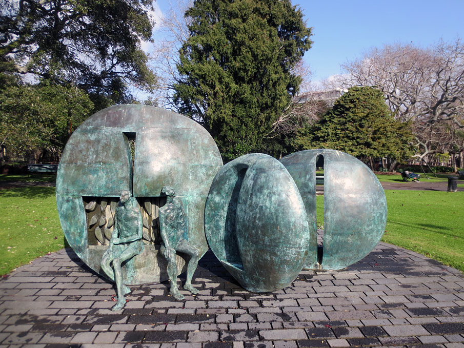
Greer Twiss sculpture 'Karangahape Rocks' erected
Start Year
1841
Type
Other
Description
Earliest burials to east of Symonds Street
Start Year
1843
startYearCirca
Type
Other
Description
Earliest burials to west of Symonds Street
Start Year
1843
Type
Modification
Description
Fencing of Anglican burial ground
Start Year
1843
Type
Original Construction
Description
Construction of house for 'keeper' of Anglican burial ground
Start Year
1844
Type
Other
Description
Earliest surviving grave marker, located in Jewish burial ground
Start Year
1850
Type
Original Construction
Description
Construction of timber mortuary chapel in Jewish burial ground, east end
Start Year
1851
Type
Modification
Description
Construction of stone walls around Jewish burial ground
Type
Original Construction
Description
Construction of sexton's house in Anglican burial ground
Period
1850s
Type
Modification
Description
Construction of stone perimeter wall in Presbyterian burial ground
Period
1860s (circa)
Start Year
1866
Type
Original Construction
Description
Construction of St Francis de Sales Chapel in Catholic burial ground
Type
Other
Description
Planting of early trees and shrubs
Period
1860s -1870s
Start Year
1876
Type
Modification
Description
Construction of boundary walls in Wesleyan and General burial ground
Type
Original Construction
Description
Construction of small timber building in Presbyterian burial ground
Period
pre-1886
Type
Original Construction
Description
Construction of house for custodian in Catholic burial ground
Period
pre-1886
Start Year
1886
Type
Modification
Description
New monument constructed for Governor Hobson's grave
Start Year
1894
Type
Relocation
Description
Relocation of St Francis de Sales Chapel to Devonport
Start Year
1907
Finish Year
1909
Type
Other
Description
Construction of Grafton Bridge, including access steps to Anglican and Wesleyan and General burial grounds
Start Year
1908
Finish Year
1909
Type
Modification
Description
Construction of memorial arch gateway, west boundary wall and railings to Anglican burial ground
Type
Other
Description
Removal of timber mortuary chapel in Jewish burial ground
Period
post-1908
Start Year
1926
Type
Original Construction
Description
Construction of ladies rest rooms on land formerly part of the Jewish burial ground
Type
Modification
Description
Concrete wall constructed on east boundary of Jewish burial ground
Period
post-1928
Start Year
1952
startYearCirca
Type
Demolished - Other
Description
Demolition of 1926 ladies rest rooms
Start Year
1952
Type
Original Construction
Description
Construction of ladies rest rooms on land formerly part of the Jewish burial ground
Type
Other
Description
Construction of park depot in Presbyterian burial ground
Period
1950s
Start Year
1953
Finish Year
1954
Type
Original Construction
Description
Construction of Centennial Memorial Chapel and Mortuary in Jewish burial ground
Start Year
2001
Type
Demolished - Other
Description
Women's rest rooms demolished
Construction Materials
Stone, timber, iron and brick - Grave markers, monuments and enclosures Brick and other - Centennial Memorial Chapel and Mortuary
Construction Professional
Name
Bartley, Edward
Type
Architect
Biography
Edward Bartley was born in Jersey in 1839, and educated in the Channel Islands where he learned techniques of the building trade from his father, an architect and builder. Bartley immigrated to New Zealand with his elder brother Robert, also an architect, while still in his teens. They eventually settled in Devonport, Auckland. Initially Edward was in the building trade but later he practised solely as an architect. He was at one time vice-president of the Auckland Institute of Architects and was also Diocesan Architect for the Church of England. Amongst Bartley's most notable works were his ecclesiastical buildings including St John's Church, Ponsonby (1881), St David's Church, Symonds Street (1880), Holy Trinity Church, Devonport, and the Synagogue (1884). He was also responsible for the Opera House (1884) and Auckland Savings Bank, Queen Street (1884).
Construction Details
Start Year
1964
Type
Other
Description
Commencement of motorway construction, removing approximately 25% of cemetery land with associated burials and graves in Anglican and Catholic burial grounds. Removal of sexton's house in Anglican burial ground
Start Year
1968
Type
Demolished - Other
Description
Memorial arch gateway to Anglican burial ground demolished
Start Year
1969
Type
Other
Description
Construction of memorials in Anglican and Catholic burial grounds incorporating cremated remains
Start Year
1969
Type
Other
Description
Greer Twiss sculpture 'Karangahape Rocks' erected
Start Year
1841
Type
Other
Description
Earliest burials to east of Symonds Street
Start Year
1843
startYearCirca
Type
Other
Description
Earliest burials to west of Symonds Street
Start Year
1843
Type
Modification
Description
Fencing of Anglican burial ground
Start Year
1843
Type
Original Construction
Description
Construction of house for 'keeper' of Anglican burial ground
Start Year
1844
Type
Other
Description
Earliest surviving grave marker, located in Jewish burial ground
Start Year
1850
Type
Original Construction
Description
Construction of timber mortuary chapel in Jewish burial ground, east end
Start Year
1851
Type
Modification
Description
Construction of stone walls around Jewish burial ground
Type
Original Construction
Description
Construction of sexton's house in Anglican burial ground
Period
1850s
Type
Modification
Description
Construction of stone perimeter wall in Presbyterian burial ground
Period
1860s (circa)
Start Year
1866
Type
Original Construction
Description
Construction of St Francis de Sales Chapel in Catholic burial ground
Type
Other
Description
Planting of early trees and shrubs
Period
1860s -1870s
Start Year
1876
Type
Modification
Description
Construction of boundary walls in Wesleyan and General burial ground
Type
Original Construction
Description
Construction of small timber building in Presbyterian burial ground
Period
pre-1886
Type
Original Construction
Description
Construction of house for custodian in Catholic burial ground
Period
pre-1886
Start Year
1886
Type
Modification
Description
New monument constructed for Governor Hobson's grave
Start Year
1894
Type
Relocation
Description
Relocation of St Francis de Sales Chapel to Devonport
Start Year
1907
Finish Year
1909
Type
Other
Description
Construction of Grafton Bridge, including access steps to Anglican and Wesleyan and General burial grounds
Start Year
1908
Finish Year
1909
Type
Modification
Description
Construction of memorial arch gateway, west boundary wall and railings to Anglican burial ground
Type
Other
Description
Removal of timber mortuary chapel in Jewish burial ground
Period
post-1908
Start Year
1926
Type
Original Construction
Description
Construction of ladies rest rooms on land formerly part of the Jewish burial ground
Type
Modification
Description
Concrete wall constructed on east boundary of Jewish burial ground
Period
post-1928
Start Year
1952
startYearCirca
Type
Demolished - Other
Description
Demolition of 1926 ladies rest rooms
Start Year
1952
Type
Original Construction
Description
Construction of ladies rest rooms on land formerly part of the Jewish burial ground
Type
Other
Description
Construction of park depot in Presbyterian burial ground
Period
1950s
Start Year
1953
Finish Year
1954
Type
Original Construction
Description
Construction of Centennial Memorial Chapel and Mortuary in Jewish burial ground
Start Year
2001
Type
Demolished - Other
Description
Women's rest rooms demolished
Construction Materials
Stone, timber, iron and brick - Grave markers, monuments and enclosures Brick and other - Centennial Memorial Chapel and Mortuary
EARLY HISTORY OF THE SITE: Land in the vicinity of Symonds Street Cemetery was occupied by Maori prior to formal European colonisation in 1840. Early inhabitants of the Auckland area are said to have included Ngati Huarere who established a fortified village at Horotiu, in the region of today's Symonds Street ridge and Queen Street gully. A later group, Te Waiohua, are traditionally believed to have occupied Te Hororoa pa at the northern end of the Symonds Street ridge before invasion by Ngati Whatua in the 1740s. A track along the Karangahape Road ridge, which reaches the Symonds Street ridge at the current cemetery site, formed a thoroughfare for food-gathering parties and others. Te Iringaorauru, a short distance to the northwest of the site, is where the body of Rauru - a member of Ngati Whatua - was hung in a tree by Te Waiohua, an event said to have been a contributory cause of the Ngati Whatua conquest of the Auckland isthmus. In the so-called Musket Wars of the early 1800s, Ngati Whatua retained cultivations at Horotiu on an occasional basis. The gardens were re-settled by Ngati Whatua in 1837, but again abandoned after Ngati Whatua's offer to sell 1214 hectares (3000 acres) to the British Crown for the creation of a colonial capital at Auckland was agreed in September 1840. Within two months, the layout for a new town was surveyed and drawn up by the acting Surveyor General, Felton Mathew, during which process the ridges were cleared of scrub. The northern end of the Symonds Street ridge was subsequently developed as a high-status area for official residences and related structures, while the Queen Street and Grafton gullies to either side of the ridge were earmarked for commercial and industrial activities respectively. ESTABLISHMENT OF A GENERAL CEMETERY (1841-1842): Although a designated graveyard was a basic requirement for the settlement, Mathew's plan did not include reference to a burial ground, nor did it specify the use of the land ultimately put to that purpose. Initial preoccupations were evidently with organising the lives of new colonists rather than making accommodation for their deaths. Mortality among incoming settlers, however, soon necessitated a place for burial. A cemetery consequently appears to have been established on the outskirts of the town during the course of 1841. Founded in the same year as a similar burial ground in the New Zealand Company settlement at Port Nicholson (Wellington), this was one of the very first urban cemeteries in New Zealand and possibly the earliest to be established under direct colonial government control. Located on the eastern side of the Symonds Street ridge, the new cemetery was sited well away from contemporary habitations. It was positioned on the steep slopes of Grafton Gully, at the mouth of which industrial activity and Maori trade was carried out. Although beyond view of the main settlement, it was on the same ridge as major official structures such as the Britomart military barracks and St Paul's Anglican Church, both under construction in 1841. The burial ground also lay beside a major natural land route from Auckland leading in a southerly direction, being situated at the junction of the Symonds Street and Karangahape Road ridges. The earliest date for the cemetery is currently unclear, but initial interments may be linked with nearby institutions. According to an eyewitness, Edward Costley (c.1796-1883), the first burial was that of a soldier, although other accounts state that a soldier's child was the earliest interment in Grafton Gully. Anglican records note that a person by the name of Emmerson was buried on 1 February 1841, although it is unclear if this was in the cemetery grounds. The earliest known grave marker, now lost, was that of nine-year old William Mason, who was buried on 13 September 1841 from the first St Paul's Church - a temporary raupo structure. Mason's father, also William Mason (1810-1897), designed the first permanent version of the church (built 1841-44) and was the colony's first architect and Superintendent of Works. The land initially set aside for burials may have covered as much as 3.75 hectares (8¾ acres). It was later said to have been for the use of all the settlement's citizenry as a general cemetery, regardless of religious affiliation. Sited away from places of worship, it was unlike most previous burial grounds established by Pakeha in New Zealand prior to 1840, such as those at Kororareka (Russell) and Paihia, which were attached to churches following the traditional British model. Churchyard burial reinforced the role of religion in the disposal and commemoration of the dead and, particularly in an English context, the authority of the Anglican Church. The creation of a general cemetery in Auckland away from its associated churches can be seen as a reflection of the greater separation between church and state in the new colony. This approach was based on a collective, egalitarian philosophy promoted by Enlightenment ideas, which was popular in progressive circles internationally in the late eighteenth and early nineteenth centuries, including among nonconformist Protestants. It may have been particularly attractive in a colonial context where there was perhaps a desire to forge a collective identity among settlers at an early stage. The separation of burial grounds from churches was also a reaction to prevailing public health concerns in Europe and elsewhere, where overcrowded cities and a growing awareness of the importance of hygiene led to attempts to close down inner-city churchyards and establish more carefully regulated cemeteries on the urban fringe. Early international experiments in this approach included the foundation of the Père-Lachaise cemetery in Paris, in 1804. British prototypes for collective graveyards on the urban fringe encompassed several developed by private enterprise in the 1820s and 1830s, although they often incorporated churches or chapels. Churchyard burial remained the standard practice in English cities until legislation enforced the closure of urban churchyards in the 1850s and 1860s. Along with a similar general cemetery established in Bolton Street, Wellington, the Auckland burial ground reflects the adoption of a socially liberal, rationalist approach to the disposal and commemoration of the dead at an initial stage in New Zealand's urban history. EXPANSION AND CONVERSION TO A DENOMINATIONAL CEMETERY (1842 - early 1850s): By the middle of 1842, representations from the Anglican and Catholic authorities, in particular, resulted in steps being taken to create separate denominational graveyards on a greatly expanded site. Sections were eventually allocated as Anglican, Catholic and Jewish burial grounds, with a fourth area provided as a general graveyard for low-church Protestant faiths and others. The expanded cemetery occupied a total area of 7.5 hectares (18½ acres), straddling both sides of the track that was to become Symonds Street. The size of each burial ground appears to have been allocated according to the proportion of each religious group's adherents in the Auckland community, as ascertained by government census. The first area to be allocated was the Anglican burial ground, which occupied a 3.75 hectare (8¾ acre) site previously used as the general cemetery. Granted by Governor William Hobson (1783-1842) on 12 July 1842, this land was formally consecrated as a Church of England cemetery by Bishop George Selwyn (1809-1878) less than a fortnight later. Resistance to common burial grounds by the Anglican authorities in Britain and elsewhere may have been partly linked to its clergy earning a stipend from burial fees and to newly emerging high-church philosophies such as those promoted by the Camden Society. Such beliefs reinforced the importance of a separate Anglican identity from other Protestant groups and, like Catholics, the need for burial in consecrated ground. Perhaps in response to Catholic representations in May 1842, Hobson's initial intent had evidently been to divide cemeteries simply between the Catholic Church and all Protestants. His change of mind to allocate separate Protestant burial grounds sparked a fierce debate that resurfaced periodically over the next few years within the Protestant community. The new situation was seen by some colonists as politically divisive and a surrender to the intolerance of religious establishments that many had sought to escape or avoid. Whatever the accuracy of this opinion, it appears to have reflected the influence that established religions had begun to assert in the new colony as a counter-reaction to Enlightenment ideas in Britain and elsewhere set in. A further 0.375 hectares (nearly 1 acre) was added to the northern end of the Anglican holding in 1843, bringing its proportion to just over half of the total cemetery area. This corresponded with statistics that classified no less than 1,100 of the approximately 1,900 residents in Auckland as Anglican. At the time of Hobson's 1842 Crown Grant to the Anglican Church, two similar plots were to be divided 'among the other denominations of Christians', although it was to be some time before these grants were formalised. Bishop Jean-Baptiste Pompallier (1801-1871) had applied in May 1842 for a burial ground for Auckland's Catholics and was advised that two acres would be granted adjoining the Protestant burial ground at the back of the town. The land, formally transferred in September 1852, comprised just over 2 hectares (5 acres) on the western side of Symonds Street and was bounded to the south by East Street, now known as Alex Evans Street. Its first interments may have occurred after June 1843, when Catholics and others were said to be excluded from burial in the Anglican graveyard unless they accepted certain ceremonies and fees. An area of approximately 1.2 hectares (5 acres) immediately to the north was similarly allocated as a general burial ground, including for members of low-church Protestant faiths such as Wesleyans, Presbyterians and Baptists, and others. Being without a place of interment in June 1843, Auckland's Presbyterians had evidently sought a separate burial ground for their own use. Their application coincided with a religious schism that occurred in Britain between the Church of Scotland and the breakaway Free Church. Largely of Free Church disposition, Auckland's Presbyterians were evidently among those who perceived the Church of England's actions in taking over the pre-existing burial ground as an assumption of traditional authority by an established church. Whilst it is possible that from an early period Presbyterians were buried in a distinct space within the new general burial ground, later approaches to have the burial ground placed under their trustees were apparently not for the purpose of keeping it for their exclusive use, but to have it 'properly fenced, and laid out for the interment of all whose friends might wish to bury them there'. Wesleyans appear to have been particularly disposed to the idea of a general graveyard as part of their broader, egalitarian philosophy. They and other nonconformist faiths kept the original 1841 approach alive. In November 1843 a relatively flat area of approximately 0.4 hectares (1 acre), also on the western side of Symonds Street, and bounded to the north by Karangahape Road, was granted for the burial of the dead of Auckland's Jewish community. A similar graveyard had been set aside in Wellington a few months earlier. Located closest to the main settlement of all the denominational burial grounds, the prominent location of Auckland's Jewish burial ground may reflect the relative importance of the Jewish community to the town's early commercial and social development. Its earliest interment was carried out in 1844. While all of the denominational burial grounds lay just outside the formal town boundaries, colonial Auckland was primarily a 'walking city' with the graveyards forming the final destination for often large and elaborate funeral corteges - an important part of Victorian burial ritual. In September 1842, the track that later became Symonds Street was cut or improved to allow the passage of a funeral procession for Governor Hobson, New Zealand's first colonial governor, who was buried in the Anglican burial ground. The Anglican graveyard was evidently depicted shortly afterwards surrounded by a post and rail fence with graves set out haphazardly, some enclosed by timber palings. There are no plantings evident and most of the land appears to be scrub. A small dwelling for a ‘keeper of the ground' may have been erected slightly later. In 1848, all of the burial grounds were described: the Anglican the largest graveyard, picturesquely situated on a ravine; ‘the cemeteries of the Scotch and the Wesleyans' on the opposite side of the road, unenclosed with about 20 wooden tombstones; the Jewish cemetery close by, carefully enclosed; and, a short distance apart from all, the resting place of the Catholics distinguished from the others by a large wooden cross. In 1850, significant improvements to the Jewish burial ground included the construction of a small timber chapel to accommodate specific mortuary rites. Tenders were also called for the erection of a drystone perimeter wall. EXPANDED DENOMINATIONAL BURIAL GROUND (early 1850s - 1885): Some reorganisation of the cemetery took place in the early 1850s due, in part, to expansion of the colonial town. By 1852, the cemetery was increased to encompass approximately 1.2 hectares (3 acres) to the north of the Anglican graveyard, for use as a Wesleyan and General burial ground. This brought the total cemetery area available for burial to its maximum size of just over 9 hectares (22½ acres). By implication, the previous general cemetery accommodating Wesleyans, Presbyterians and others appears likely to have been reserved for Presbyterians from this time, although some burials of individuals of other Protestant denominations who already had family members interred there appear to have continued. The first burial in the new extension was that of James Martin Buller, a son of the Wesleyan missionary, the Reverend James Buller (1812-1864), in September 1852. Crown grants formalising the separate landholdings as the Presbyterian, and Wesleyan and General cemeteries were not finalised until 1869 and 1872 respectively. Expansion of the town closer to the cemetery created public health issues. Concerns that seepage from the Anglican burial ground might cause water in Mechanics Bay to become undrinkable led the Church of England to declare that it would introduce rules governing the size, depth and location of graves, and the space enclosed around them. The replacement of a keeper's house with a sexton's residence at the southern end of the burial ground may be linked with greater supervision. By this time interments in the Anglican graveyard numbered approximately 400, although no formal records were kept. Some regulation was already in place in the Catholic graveyard. Significant changes in the 1860s and 1870s included the creation of more conscious layouts and beautification of the burial grounds. This development followed the emergence of Picturesque garden-cemeteries in Europe and elsewhere, and the subsequent influence of landscape designers such as John Loudon (1783-1843). Garden-cemeteries were promoted as places of quiet reflection and moral edification, and as conscious historical records. Perambulation, and contemplation of the gravestones, was encouraged often leading to a greater emphasis on the presentation of funerary monuments. In Auckland, this process coincided with the spread of residential settlement to the cemetery surrounds and beyond. It also occurred at a time of flux in Auckland's development, when the town sought to redefine its identity following transfer of its role as colonial capital to Wellington (1865). The increased emphasis on beautification effectively heralded the cemetery's heyday. In 1864, the Catholic cemetery was cleared of scrub and lawn created. Consideration was given to the laying out of walks and the erection of a stone wall along Symonds Street to prevent damage from cattle. A timber mortuary chapel, the cruciform-shaped St Francis de Sales was opened in 1866, designed by the noted Auckland architect, Edward Mahoney (1824/25?-1895). Before the mid 1880s, a caretaker's house was also erected, looking out over a formal layout of linear paths flanked by orderly burials. Initially with few or no trees, perimeter plantings of conifers had by this time been augmented by Pinus radiata, which lined a central carriageway. Poplars and weeping willows were also established in a shallow gully largely unused for interment, which physically separated Catholic graves from Protestant burials to the north. The trees themselves had symbolic meaning. Traditionally, evergreens represented the eternal afterlife, and weeping willows symbolised mourning and loss. Changes were similarly made to other burial grounds in the cemetery. In 1866, the Anglican trustees invited public subscriptions to enable walls to be repaired and walks gravelled. Unspecified plants had been put in at regular intervals along some pathways, and steps cut by 1868. The first oaks, symbolic of Englishness and stoutness of resolve, are said to have been established in association with the grave of Governor Hobson (d.1842). Pinus radiata plantings were made in the 1870s. An 1887 plan indicates the extent to which a consciously irregular network of meandering paths was created, running along the length of the steep slopes of the Anglican graveyard as well as up and down its main gradient. Largely devoid of trees prior to 1868, the Anglican grounds were increasingly concealed by foliage by the 1880s. Both the layout and foliage contributed to the graveyard's Picturesque appearance, a style popular in many European gardens and cemeteries of a similar and earlier period. In the Presbyterian graveyard, improvements by the 1880s included a modest gabled structure towards the western end. Its layout may have combined the formality of the Catholic burial ground with the more irregular nature of its Anglican counterpart. Both linear and meandering paths were evidently adopted. In the Wesleyan and General graveyard, subscriptions had been canvassed in 1866 for the completion of works in its neglected grounds. A decade later, inspired by improvements to the Presbyterian graveyard, footpaths and drains were formed and cut, rubbish cleared away and a contract let for the construction of boundary walls and fences. Money was also spent on plans, cemetery gates and plantings to counter unfavourable comment in the press. From 1876, the Wesleyan and General burial ground was known as the ‘Auckland Public Cemetery'. The Jewish graveyard may have been more orderly from an early stage. It encompassed a concentration of burials at its western end, which appear to have been arranged in rows. The earlier timber mortuary chapel continued in use, located close to an entrance in the Symonds Street frontage at the eastern end of the site. A central linear path led down from the chapel to the graves, which by the 1880s may have been interspersed with plantings. Trees in both the Jewish and adjoining Presbyterian graveyards included pines and cypress. The varying layout and appearance of each graveyard can be seen to have reinforced separate religious and other aspects of cultural identity within the community. Messages differed according to the background and philosophy of each denomination. The Picturesque influences of the Anglican cemetery can be linked with conservative reactions to formal Enlightenment approaches within the Church of England, emphasising a shift away from symmetry and reliance on reason. The more rectilinear layout of the Catholic graveyard has been linked to the particular influence of French Marist missionaries in Auckland, who would have been acquainted with the reformation of French cemeteries in 1808 stimulated by the rationalist ideas of the French Revolution (1789). The Jewish cemetery reflected specific aspects of religious practice, including the particularly important link between mortuary preparation - through the Tahara or purification process - and burial. Varying religious and other cultural identities were also promoted through the form and inscriptions of individual monuments. Many of the Jewish grave markers were inscribed in Hebrew. Numerous of those in the Presbyterian graveyard referred to Scottish origins. However, there were also similarities, both in monuments and in burial practice, which reflected common bonds. All funerary practice involved burial, and burials were carried out using a standard east-west orientation. Many of the monuments were also carved or supplied by the same masons. As the cemetery grew in size and importance, its impact on the surrounding landscape correspondingly increased. In 1865, the Church of the Holy Sepulchre opened in a street overlooking the Anglican graveyard, and in the 1880s, St Benedict's Church and other Catholic buildings were similarly erected beside the Catholic burial ground. Commercial opportunities arose as the Victorian ‘celebration of death' developed into a major industry. By 1891, five undertaking premises were present in nearby Karangahape Road and Wellesley Street East alone. Several monumental masons also had businesses in the area, including Gillingham's on Karangahape Road. DECLINE AND GENERAL CLOSURE (1886-1909): Concerns about the effects of the cemetery on public health ultimately had an impact on its operations. Early worries about drinking water in Mechanics Bay were followed by apprehensions about noxious gases in the early 1860s, when fumes were said to be noticeable as far afield as Khyber Pass Road. An 1862 Select Committee on Burial Grounds saw no immediate need to close the cemetery, but advocated the opening of new facilities away from urban settlement. In 1871, an Act to Regulate Burials near the City of Auckland allowed trustees to enforce ‘exclusive interment' or ban burials entirely, although a further 1874 Act allowed the interment of blood relatives and a marriage partner of those already buried. From 1878, the Anglican trustees accepted for burial only those who had already purchased a plot, overcrowding having become a major issue. FOR THE REMAINDER OF THIS HISTORICAL DESCRIPTION PLEASE REFER TO THE REGISTRATION REPORT HELD AT THE AUCKLAND OFFICE OF NZHPT.
EARLY HISTORY OF THE SITE: Land in the vicinity of Symonds Street Cemetery was occupied by Maori prior to formal European colonisation in 1840. Early inhabitants of the Auckland area are said to have included Ngati Huarere who established a fortified village at Horotiu, in the region of today's Symonds Street ridge and Queen Street gully. A later group, Te Waiohua, are traditionally believed to have occupied Te Hororoa pa at the northern end of the Symonds Street ridge before invasion by Ngati Whatua in the 1740s. A track along the Karangahape Road ridge, which reaches the Symonds Street ridge at the current cemetery site, formed a thoroughfare for food-gathering parties and others. Te Iringaorauru, a short distance to the northwest of the site, is where the body of Rauru - a member of Ngati Whatua - was hung in a tree by Te Waiohua, an event said to have been a contributory cause of the Ngati Whatua conquest of the Auckland isthmus. In the so-called Musket Wars of the early 1800s, Ngati Whatua retained cultivations at Horotiu on an occasional basis. The gardens were re-settled by Ngati Whatua in 1837, but again abandoned after Ngati Whatua's offer to sell 1214 hectares (3000 acres) to the British Crown for the creation of a colonial capital at Auckland was agreed in September 1840. Within two months, the layout for a new town was surveyed and drawn up by the acting Surveyor General, Felton Mathew, during which process the ridges were cleared of scrub. The northern end of the Symonds Street ridge was subsequently developed as a high-status area for official residences and related structures, while the Queen Street and Grafton gullies to either side of the ridge were earmarked for commercial and industrial activities respectively. ESTABLISHMENT OF A GENERAL CEMETERY (1841-1842): Although a designated graveyard was a basic requirement for the settlement, Mathew's plan did not include reference to a burial ground, nor did it specify the use of the land ultimately put to that purpose. Initial preoccupations were evidently with organising the lives of new colonists rather than making accommodation for their deaths. Mortality among incoming settlers, however, soon necessitated a place for burial. A cemetery consequently appears to have been established on the outskirts of the town during the course of 1841. Founded in the same year as a similar burial ground in the New Zealand Company settlement at Port Nicholson (Wellington), this was one of the very first urban cemeteries in New Zealand and possibly the earliest to be established under direct colonial government control. Located on the eastern side of the Symonds Street ridge, the new cemetery was sited well away from contemporary habitations. It was positioned on the steep slopes of Grafton Gully, at the mouth of which industrial activity and Maori trade was carried out. Although beyond view of the main settlement, it was on the same ridge as major official structures such as the Britomart military barracks and St Paul's Anglican Church, both under construction in 1841. The burial ground also lay beside a major natural land route from Auckland leading in a southerly direction, being situated at the junction of the Symonds Street and Karangahape Road ridges. The earliest date for the cemetery is currently unclear, but initial interments may be linked with nearby institutions. According to an eyewitness, Edward Costley (c.1796-1883), the first burial was that of a soldier, although other accounts state that a soldier's child was the earliest interment in Grafton Gully. Anglican records note that a person by the name of Emmerson was buried on 1 February 1841, although it is unclear if this was in the cemetery grounds. The earliest known grave marker, now lost, was that of nine-year old William Mason, who was buried on 13 September 1841 from the first St Paul's Church - a temporary raupo structure. Mason's father, also William Mason (1810-1897), designed the first permanent version of the church (built 1841-44) and was the colony's first architect and Superintendent of Works. The land initially set aside for burials may have covered as much as 3.75 hectares (8¾ acres). It was later said to have been for the use of all the settlement's citizenry as a general cemetery, regardless of religious affiliation. Sited away from places of worship, it was unlike most previous burial grounds established by Pakeha in New Zealand prior to 1840, such as those at Kororareka (Russell) and Paihia, which were attached to churches following the traditional British model. Churchyard burial reinforced the role of religion in the disposal and commemoration of the dead and, particularly in an English context, the authority of the Anglican Church. The creation of a general cemetery in Auckland away from its associated churches can be seen as a reflection of the greater separation between church and state in the new colony. This approach was based on a collective, egalitarian philosophy promoted by Enlightenment ideas, which was popular in progressive circles internationally in the late eighteenth and early nineteenth centuries, including among nonconformist Protestants. It may have been particularly attractive in a colonial context where there was perhaps a desire to forge a collective identity among settlers at an early stage. The separation of burial grounds from churches was also a reaction to prevailing public health concerns in Europe and elsewhere, where overcrowded cities and a growing awareness of the importance of hygiene led to attempts to close down inner-city churchyards and establish more carefully regulated cemeteries on the urban fringe. Early international experiments in this approach included the foundation of the Père-Lachaise cemetery in Paris, in 1804. British prototypes for collective graveyards on the urban fringe encompassed several developed by private enterprise in the 1820s and 1830s, although they often incorporated churches or chapels. Churchyard burial remained the standard practice in English cities until legislation enforced the closure of urban churchyards in the 1850s and 1860s. Along with a similar general cemetery established in Bolton Street, Wellington, the Auckland burial ground reflects the adoption of a socially liberal, rationalist approach to the disposal and commemoration of the dead at an initial stage in New Zealand's urban history. EXPANSION AND CONVERSION TO A DENOMINATIONAL CEMETERY (1842 - early 1850s): By the middle of 1842, representations from the Anglican and Catholic authorities, in particular, resulted in steps being taken to create separate denominational graveyards on a greatly expanded site. Sections were eventually allocated as Anglican, Catholic and Jewish burial grounds, with a fourth area provided as a general graveyard for low-church Protestant faiths and others. The expanded cemetery occupied a total area of 7.5 hectares (18½ acres), straddling both sides of the track that was to become Symonds Street. The size of each burial ground appears to have been allocated according to the proportion of each religious group's adherents in the Auckland community, as ascertained by government census. The first area to be allocated was the Anglican burial ground, which occupied a 3.75 hectare (8¾ acre) site previously used as the general cemetery. Granted by Governor William Hobson (1783-1842) on 12 July 1842, this land was formally consecrated as a Church of England cemetery by Bishop George Selwyn (1809-1878) less than a fortnight later. Resistance to common burial grounds by the Anglican authorities in Britain and elsewhere may have been partly linked to its clergy earning a stipend from burial fees and to newly emerging high-church philosophies such as those promoted by the Camden Society. Such beliefs reinforced the importance of a separate Anglican identity from other Protestant groups and, like Catholics, the need for burial in consecrated ground. Perhaps in response to Catholic representations in May 1842, Hobson's initial intent had evidently been to divide cemeteries simply between the Catholic Church and all Protestants. His change of mind to allocate separate Protestant burial grounds sparked a fierce debate that resurfaced periodically over the next few years within the Protestant community. The new situation was seen by some colonists as politically divisive and a surrender to the intolerance of religious establishments that many had sought to escape or avoid. Whatever the accuracy of this opinion, it appears to have reflected the influence that established religions had begun to assert in the new colony as a counter-reaction to Enlightenment ideas in Britain and elsewhere set in. A further 0.375 hectares (nearly 1 acre) was added to the northern end of the Anglican holding in 1843, bringing its proportion to just over half of the total cemetery area. This corresponded with statistics that classified no less than 1,100 of the approximately 1,900 residents in Auckland as Anglican. At the time of Hobson's 1842 Crown Grant to the Anglican Church, two similar plots were to be divided 'among the other denominations of Christians', although it was to be some time before these grants were formalised. Bishop Jean-Baptiste Pompallier (1801-1871) had applied in May 1842 for a burial ground for Auckland's Catholics and was advised that two acres would be granted adjoining the Protestant burial ground at the back of the town. The land, formally transferred in September 1852, comprised just over 2 hectares (5 acres) on the western side of Symonds Street and was bounded to the south by East Street, now known as Alex Evans Street. Its first interments may have occurred after June 1843, when Catholics and others were said to be excluded from burial in the Anglican graveyard unless they accepted certain ceremonies and fees. An area of approximately 1.2 hectares (5 acres) immediately to the north was similarly allocated as a general burial ground, including for members of low-church Protestant faiths such as Wesleyans, Presbyterians and Baptists, and others. Being without a place of interment in June 1843, Auckland's Presbyterians had evidently sought a separate burial ground for their own use. Their application coincided with a religious schism that occurred in Britain between the Church of Scotland and the breakaway Free Church. Largely of Free Church disposition, Auckland's Presbyterians were evidently among those who perceived the Church of England's actions in taking over the pre-existing burial ground as an assumption of traditional authority by an established church. Whilst it is possible that from an early period Presbyterians were buried in a distinct space within the new general burial ground, later approaches to have the burial ground placed under their trustees were apparently not for the purpose of keeping it for their exclusive use, but to have it 'properly fenced, and laid out for the interment of all whose friends might wish to bury them there'. Wesleyans appear to have been particularly disposed to the idea of a general graveyard as part of their broader, egalitarian philosophy. They and other nonconformist faiths kept the original 1841 approach alive. In November 1843 a relatively flat area of approximately 0.4 hectares (1 acre), also on the western side of Symonds Street, and bounded to the north by Karangahape Road, was granted for the burial of the dead of Auckland's Jewish community. A similar graveyard had been set aside in Wellington a few months earlier. Located closest to the main settlement of all the denominational burial grounds, the prominent location of Auckland's Jewish burial ground may reflect the relative importance of the Jewish community to the town's early commercial and social development. Its earliest interment was carried out in 1844. While all of the denominational burial grounds lay just outside the formal town boundaries, colonial Auckland was primarily a 'walking city' with the graveyards forming the final destination for often large and elaborate funeral corteges - an important part of Victorian burial ritual. In September 1842, the track that later became Symonds Street was cut or improved to allow the passage of a funeral procession for Governor Hobson, New Zealand's first colonial governor, who was buried in the Anglican burial ground. The Anglican graveyard was evidently depicted shortly afterwards surrounded by a post and rail fence with graves set out haphazardly, some enclosed by timber palings. There are no plantings evident and most of the land appears to be scrub. A small dwelling for a ‘keeper of the ground' may have been erected slightly later. In 1848, all of the burial grounds were described: the Anglican the largest graveyard, picturesquely situated on a ravine; ‘the cemeteries of the Scotch and the Wesleyans' on the opposite side of the road, unenclosed with about 20 wooden tombstones; the Jewish cemetery close by, carefully enclosed; and, a short distance apart from all, the resting place of the Catholics distinguished from the others by a large wooden cross. In 1850, significant improvements to the Jewish burial ground included the construction of a small timber chapel to accommodate specific mortuary rites. Tenders were also called for the erection of a drystone perimeter wall. EXPANDED DENOMINATIONAL BURIAL GROUND (early 1850s - 1885): Some reorganisation of the cemetery took place in the early 1850s due, in part, to expansion of the colonial town. By 1852, the cemetery was increased to encompass approximately 1.2 hectares (3 acres) to the north of the Anglican graveyard, for use as a Wesleyan and General burial ground. This brought the total cemetery area available for burial to its maximum size of just over 9 hectares (22½ acres). By implication, the previous general cemetery accommodating Wesleyans, Presbyterians and others appears likely to have been reserved for Presbyterians from this time, although some burials of individuals of other Protestant denominations who already had family members interred there appear to have continued. The first burial in the new extension was that of James Martin Buller, a son of the Wesleyan missionary, the Reverend James Buller (1812-1864), in September 1852. Crown grants formalising the separate landholdings as the Presbyterian, and Wesleyan and General cemeteries were not finalised until 1869 and 1872 respectively. Expansion of the town closer to the cemetery created public health issues. Concerns that seepage from the Anglican burial ground might cause water in Mechanics Bay to become undrinkable led the Church of England to declare that it would introduce rules governing the size, depth and location of graves, and the space enclosed around them. The replacement of a keeper's house with a sexton's residence at the southern end of the burial ground may be linked with greater supervision. By this time interments in the Anglican graveyard numbered approximately 400, although no formal records were kept. Some regulation was already in place in the Catholic graveyard. Significant changes in the 1860s and 1870s included the creation of more conscious layouts and beautification of the burial grounds. This development followed the emergence of Picturesque garden-cemeteries in Europe and elsewhere, and the subsequent influence of landscape designers such as John Loudon (1783-1843). Garden-cemeteries were promoted as places of quiet reflection and moral edification, and as conscious historical records. Perambulation, and contemplation of the gravestones, was encouraged often leading to a greater emphasis on the presentation of funerary monuments. In Auckland, this process coincided with the spread of residential settlement to the cemetery surrounds and beyond. It also occurred at a time of flux in Auckland's development, when the town sought to redefine its identity following transfer of its role as colonial capital to Wellington (1865). The increased emphasis on beautification effectively heralded the cemetery's heyday. In 1864, the Catholic cemetery was cleared of scrub and lawn created. Consideration was given to the laying out of walks and the erection of a stone wall along Symonds Street to prevent damage from cattle. A timber mortuary chapel, the cruciform-shaped St Francis de Sales was opened in 1866, designed by the noted Auckland architect, Edward Mahoney (1824/25?-1895). Before the mid 1880s, a caretaker's house was also erected, looking out over a formal layout of linear paths flanked by orderly burials. Initially with few or no trees, perimeter plantings of conifers had by this time been augmented by Pinus radiata, which lined a central carriageway. Poplars and weeping willows were also established in a shallow gully largely unused for interment, which physically separated Catholic graves from Protestant burials to the north. The trees themselves had symbolic meaning. Traditionally, evergreens represented the eternal afterlife, and weeping willows symbolised mourning and loss. Changes were similarly made to other burial grounds in the cemetery. In 1866, the Anglican trustees invited public subscriptions to enable walls to be repaired and walks gravelled. Unspecified plants had been put in at regular intervals along some pathways, and steps cut by 1868. The first oaks, symbolic of Englishness and stoutness of resolve, are said to have been established in association with the grave of Governor Hobson (d.1842). Pinus radiata plantings were made in the 1870s. An 1887 plan indicates the extent to which a consciously irregular network of meandering paths was created, running along the length of the steep slopes of the Anglican graveyard as well as up and down its main gradient. Largely devoid of trees prior to 1868, the Anglican grounds were increasingly concealed by foliage by the 1880s. Both the layout and foliage contributed to the graveyard's Picturesque appearance, a style popular in many European gardens and cemeteries of a similar and earlier period. In the Presbyterian graveyard, improvements by the 1880s included a modest gabled structure towards the western end. Its layout may have combined the formality of the Catholic burial ground with the more irregular nature of its Anglican counterpart. Both linear and meandering paths were evidently adopted. In the Wesleyan and General graveyard, subscriptions had been canvassed in 1866 for the completion of works in its neglected grounds. A decade later, inspired by improvements to the Presbyterian graveyard, footpaths and drains were formed and cut, rubbish cleared away and a contract let for the construction of boundary walls and fences. Money was also spent on plans, cemetery gates and plantings to counter unfavourable comment in the press. From 1876, the Wesleyan and General burial ground was known as the ‘Auckland Public Cemetery'. The Jewish graveyard may have been more orderly from an early stage. It encompassed a concentration of burials at its western end, which appear to have been arranged in rows. The earlier timber mortuary chapel continued in use, located close to an entrance in the Symonds Street frontage at the eastern end of the site. A central linear path led down from the chapel to the graves, which by the 1880s may have been interspersed with plantings. Trees in both the Jewish and adjoining Presbyterian graveyards included pines and cypress. The varying layout and appearance of each graveyard can be seen to have reinforced separate religious and other aspects of cultural identity within the community. Messages differed according to the background and philosophy of each denomination. The Picturesque influences of the Anglican cemetery can be linked with conservative reactions to formal Enlightenment approaches within the Church of England, emphasising a shift away from symmetry and reliance on reason. The more rectilinear layout of the Catholic graveyard has been linked to the particular influence of French Marist missionaries in Auckland, who would have been acquainted with the reformation of French cemeteries in 1808 stimulated by the rationalist ideas of the French Revolution (1789). The Jewish cemetery reflected specific aspects of religious practice, including the particularly important link between mortuary preparation - through the Tahara or purification process - and burial. Varying religious and other cultural identities were also promoted through the form and inscriptions of individual monuments. Many of the Jewish grave markers were inscribed in Hebrew. Numerous of those in the Presbyterian graveyard referred to Scottish origins. However, there were also similarities, both in monuments and in burial practice, which reflected common bonds. All funerary practice involved burial, and burials were carried out using a standard east-west orientation. Many of the monuments were also carved or supplied by the same masons. As the cemetery grew in size and importance, its impact on the surrounding landscape correspondingly increased. In 1865, the Church of the Holy Sepulchre opened in a street overlooking the Anglican graveyard, and in the 1880s, St Benedict's Church and other Catholic buildings were similarly erected beside the Catholic burial ground. Commercial opportunities arose as the Victorian ‘celebration of death' developed into a major industry. By 1891, five undertaking premises were present in nearby Karangahape Road and Wellesley Street East alone. Several monumental masons also had businesses in the area, including Gillingham's on Karangahape Road. DECLINE AND GENERAL CLOSURE (1886-1909): Concerns about the effects of the cemetery on public health ultimately had an impact on its operations. Early worries about drinking water in Mechanics Bay were followed by apprehensions about noxious gases in the early 1860s, when fumes were said to be noticeable as far afield as Khyber Pass Road. An 1862 Select Committee on Burial Grounds saw no immediate need to close the cemetery, but advocated the opening of new facilities away from urban settlement. In 1871, an Act to Regulate Burials near the City of Auckland allowed trustees to enforce ‘exclusive interment' or ban burials entirely, although a further 1874 Act allowed the interment of blood relatives and a marriage partner of those already buried. From 1878, the Anglican trustees accepted for burial only those who had already purchased a plot, overcrowding having become a major issue. FOR THE REMAINDER OF THIS HISTORICAL DESCRIPTION PLEASE REFER TO THE REGISTRATION REPORT HELD AT THE AUCKLAND OFFICE OF NZHPT.
Construction Professionals: Bartley, Edward (architect) Buchanan (monumental mason) Bouskill (monumental mason) Gillingham M. (monumental mason) Hutchinson (monumental mason) McNab (monumental mason) Mason (monumental mason) Parkinson (monumental mason) Tait Brothers (monumental masons) Thomas W. (monumental mason) Context: The Symonds Street Cemetery is located in central Auckland, on the southeast fringe of its Central Business District (CBD). Situated on the Symonds Street ridge and part of the Grafton Gully, it is prominently positioned at the junction of four major arterial roads: Symonds Street, Grafton Bridge, the Southern Motorway and Karangahape Road. Both Symonds Street and Grafton Bridge bisect the cemetery grounds, as does an on-ramp for the Southern Motorway. The surviving cemetery occupies approximately 6 hectares and is L-shaped in plan. The site encompasses slightly undulating ground to the west of Symonds Street at its intersection with Karangahape Road, and steeper ground to the east of Symonds Street at its junction with St Martins Lane. The cemetery constitutes a notable landmark as viewed from the Southern Motorway, Symonds Street and elsewhere, encompassing heavily wooded and green spaces within an otherwise built-up area. The site is closely associated with many nearby places of heritage significance. Part of the cemetery's eastern portion is spanned by Grafton Bridge (NZHPT Register # 16, Category I historic place) and is also adjoined by a Bus Shelter and Toilets building (NZHPT Register # 561, Category II historic place). The motorway system itself is considered by the Institute of Professional Engineers of New Zealand (IPENZ) to be a place of engineering heritage value. Immediately to the south of the motorway is the Upper Symonds Street historic area (NZHPT Register # 7367), while the Karangahape Road Precinct lies to the west of the cemetery. Together these form a heritage character area with numerous late nineteenth- and early twentieth-century buildings, some of which are registered with the NZHPT. Further historic places are also located further north on the Symonds Street ridge, including several with religious links to the cemetery such as St Andrew's Presbyterian Church (NZHPT Register # 20, Category I historic place) and the former Jewish Synagogue (NZHPT Register 578, Category I historic place). Spatial layout and components: The present layout of the cemetery is physically divided into two portions (western and eastern) by Symonds Street. The eastern portion encompasses a broadly rectangular area of some 3.4 hectares, which has St Martins Lane, a motorway extension in Grafton Gully and the Southern Motorway as its other boundaries. The western portion encompasses a slightly smaller rectangular area, approximately 2.4 hectares in size, which is bounded to its north, west and south by Karangahape Road, buildings fronting Upper Queen Street and the Southern Motorway. Between these two portions, Symonds Street forms a busy thoroughfare with strong physical and historical connections to the cemetery site. Its carriageway is currently substantially above the ground level of the cemetery on either side, effectively forming a raised embankment. Earlier road levels may be preserved beneath the current carriageway. Both portions on either side of Symonds Street incorporate remnants of the cemetery as laid out in the 1840s and 1850s. These can be described according to their main denominational use from approximately 1852, when the cemetery reached its full size. The eastern portion comprises i) the Wesleyan and General burial ground (from 1852), and ii) surviving parts of the Anglican graveyard (from 1842-3) including the site of the 1841 General Cemetery. The western portion comprises iii) surviving parts of the Catholic burial ground (from circa 1843), iv) the Presbyterian graveyard (from circa 1852, but previously used as the Wesleyan, Presbyterian and General graveyard), and v) the Jewish burial ground (from 1843) including what is currently Pigeon Park. i) Wesleyan and General burial ground: The Wesleyan and General burial ground occupies the northern part of the cemetery on its eastern side. Its ground is comparatively flat adjoining Symonds Street but becomes steeper as it descends eastwards into Grafton Gully. It is bounded on its northern side by a low basalt wall, and by a retaining wall with picket fence on its western side. Access into the graveyard is provided by formal steps adjacent to Grafton Bridge (NZHPT Register # 16, Category I historic place), near its southern end, and two further entrances - one in its northwestern corner and the other further east on its north boundary. A parking area beside St Martins Lane encroaches on cemetery land, and where it does so is included inside the registration boundary. Both the Grafton Bridge steps and a brick Bus Shelter and Toilets building (NZHPT Register # 561, Category II historic place) extend partly into the western part of the burial ground. These are excluded from the cemetery registration as they are separately registered. There is no longer any formal boundary between the Wesleyan and Anglican sections of the cemetery. Under large trees, predominantly oak and pohutukawa, are a mixture of plots marked by slabs and enclosures (some simple cast iron railings with hooped heads), and freestanding headstones. Four well-defined pathways run in a northerly direction. Part of the lowest and most curvilinear of the paths may incorporate part of the alignment of an old track that led from St Martins Lane down across a former pedestrian bridge to Bridge Street on the opposite side of Grafton Gully. Towards the southern end of the burial ground the network of paths is more dense. Most burial plots are east facing and occupy the terrace's upper slopes. Loosely organised in rows, the pattern is occasionally broken by isolated burials within path alignments. On the middle slopes, burials are less dense. Lying on the ground are remnants of badly damaged timber picket enclosures of a type once common throughout the whole cemetery. There are few burials below the lower loop path that leads south from the St Martins Lane boundary. A gravestone close to Symonds Street and the north side of the bridge marks an early burial in the Wesleyan section, that of Elizabeth Goldsworthy who died in 1855. This and many other headstones have simple round heads with decorative carving in the upper section. Patterns range from botanical themes, to decorative swags, wreaths and ribbons, angel figures, broken trees and more traditional Gothic styles such as that of the wife of architect Richard Keals, Catherine. Inscriptions include evangelical references such as, 'Mary Conway lives with God'. In some cases the headstones of family groups stand alongside one another such as those marking the burials of George Graham, Alexander Wiseman and other relations. A First World War (1914-18) era monument in the Rowe family plot adjoining St Martins Lane refers to a Stan Rowe and two other men with different surnames, all buried in France. ii) Anglican burial ground: The Anglican burial ground contains the most dense concentration of grave markers in the cemetery, and probably also burials. It incorporates similar terrain to that in the Wesleyan and General graveyard, comprising an oak-covered terrace parallel to Symonds Street and steeply-sloping land running downward to the east. The eastward slope is bisected by a gully that runs towards a stream bed on the eastern boundary. Densely wooded with mature oaks and pines, the lower and southern slopes also include a developing understorey of New Zealand vegetation that includes ponga, ti tree and coprosma. The burial ground is bounded to its east and south by busy motorway corridors, and its western part is cut through by a motorway on-ramp. The on-ramp separates the main part of the burial ground from the base of a buttressed western boundary wall probably erected in 1909, which survives on the eastern side of the Symonds Street road reserve. This wall includes the remnants of an arched entrance erected at the same time, which was largely demolished during motorway construction in the 1960s. The wall includes settings for iron railings, demonstrating that the graveyard was intended to be seen from the road after conversion to a Public Reserve. The current western boundary comprises a large basalt retaining wall separating the main burial ground from the motorway on-ramp, against which several repositioned grave markers have been set. The wall also incorporates a commemorative plaque to an early settler, William Trusted (1801-1856), which was dedicated in 1998. The main access point into the Anglican graveyard is now via steps on the southern side of Grafton Bridge. As with those in the Wesleyan section, these are excluded from the registration as they are separately registered. Towards the cemetery's northwest corner are the graves of early colonial government personnel, military figures, clergy and their families. Foremost among these is the grave of Governor Hobson, which forms the centre piece of a memorial constructed in 1969 to commemorate those Anglicans whose graves were removed as part of the motorway development. Hobson's grave has been incorporated into the paving of the modernist concrete structure. The 1969 memorial comprises two upright concrete walls which carry polished marble panels bearing the names of those who were disinterred, cremated and reburied beneath the monument, and the burial dates of unnamed individuals. Indicative of the Picturesque style said to have influenced development of this burial ground, a series of paths with cross connections winds through the landscape, providing access to parts of a variable terrain. In the north end of the cemetery are successive rows of burial plots without intervening gaps for paths, in many cases resulting in a tightly packed mixture of headstones and enclosures. There is considerably greater variety in enclosures and monument types than in some other sections of the Symonds Street Cemetery. This is perhaps partly attributable to the greater number of burials and extended time span. Notable examples of burial enclosures include the grave of Isabella Nelson (d.1882), which encompasses Art Nouveau-style ironwork depicting dying flowering vines with alternating front and back views of the blooms. Of the few surviving timber enclosures once common throughout the burial ground, is an example with dowel railings that surrounds the headstone of S. Elizabeth Monk, who died in 1870. Another is a picket fence enclosure with sturdy corner posts and large acorn-shaped capitals. An interesting brick monument is that to the family of brickmaker, William Parker, who is believed to have been the builder and owner of the Fitzroy Hotel (NZHPT Register # 7582, Category I historic place) constructed in nearby Wakefield Street in 1854. The monument's plinth incorporates fine pointing and shaped bricks presumably manufactured by his family business, effectively advertising the skill and standing of the tomb's occupants and makers. Although most surviving markers and monuments are of stone, one unusual example is entirely of cast iron. Two timber grave markers survive on an upper slope towards the southern end of the cemetery, but are in a precarious condition and bear no legible details. The largest grave marker is a stone monument to a wealthy merchant, John Smith, who owned a grand house now known as Pembridge (NZHPT Register # 9956, Category I historic place) in Princes Street. The stone and brick base of the monument is in an advanced state of disintegration, exposing internal lengths of iron rail reinforcement that is inadequate to bear the weight of a large stylised broken column that rises from its substantial plinth. The broken column symbolises a life cut short. At the southern end of the site, burials and grave markers extend to within a few metres of the boundary fence between the burial ground and motorway. A curvilinear path with basalt steps, and trees such as oak and pine also survives. Some modification, however, has occurred immediately adjacent to the fence, including the removal of burials during motorway construction in the 1960s. iii) Catholic burial ground: Most of the Catholic burial ground has been removed by motorway construction but its surviving ground is undulating. A shallow gully in the eastern part of the burial ground extends northwards before veering at right angles to run westwards along the northern boundary of the graveyard. Overall, the land slopes down from south to north, with surviving burials situated largely on the remains of a north facing ridge in the mid to west section of the site. Compared with other parts of the cemetery there are relatively few monuments, and there may be as few as 42 burial plots. Most marked burials within the surviving area appear to post-date 1870. There appear to have been few marked burials in the gully area closest to the Presbyterian graveyard to the north. The burial ground has a parkland character in places, although it is more heavily wooded elsewhere, with oak the predominant species. Prior to construction of the motorway, the main access to the burial ground was from its southern end. Currently, the only direct access other than from the Presbyterian burial ground is via a pedestrian ramp from Symonds Street. A short length of basalt retaining wall, surmounted by a later concrete addition, appears to be the only surviving part of the graveyard's early east boundary. A nineteenth-century caretaker's house was located at the foot of the wall, where archaeological remains may survive. The north boundary is delineated for some of its length by a shallow ditch, but is otherwise unenclosed. Elements of the nineteenth-century layout in the graveyard are visible, including the general location of two historic pathways running in a north and northwest direction from the south end. Grave sites commonly include plastered brick or concrete surrounds and many incorporate flat slabs rather than vertical headstones. Some are enclosed by low rail surrounds, while a few have tall cast iron railings with simple hooped tops. Overall the monuments are less lavish than those in the other burial grounds. Some headstones appear to be of a style not seen in the other sections and have inscriptions reflecting tenets of the Catholic faith including invocation to prayer. One simple inscription reads, 'Pray for the souls of Marcella Lake, died 13 November 1872 and her infant children. RIP'. Adjoining the south boundary on the highest point of the surviving site is a modernist-style memorial in concrete, commemorating those within the Catholic graveyard whose graves were disinterred for motorway construction. Names are recorded on several bronze plaques, which are attached to a low plinth. Stylised slab seating is set within a paved area surrounding the memorial. To the west, a few headstones from graves removed for the motorway have been set lying face up in concrete. One commemorates Legislative Council Member Patrick Dignan and wife Mary who arrived in Auckland in 1841, together with several members of their family. iv) Presbyterian burial ground: The Presbyterian burial ground occupies undulating ground that has been unaffected by motorway activity. In general, the ground slopes down towards the west and south. A spring located near the foot of the northern slope feeds a vestigial stream that runs across the western third of the site. Incorporating a large number of trees and shrubs, the burial ground retains a park-like appearance. Most of the tree species are deciduous, but they also include cypress and pohutukawa. The burial ground has two main access points: one access is through Pigeon Park from Karangahape Road and another is from Symonds Street via an earth ramp midway along the east boundary. The east boundary consists of a stone retaining wall, similar to that bounding the adjoining Catholic graveyard, although there is a straight join between the two. The boundary wall in the Presbyterian burial ground has been constructed in at least three horizontal phases, suggesting a progressive building up of the level of Symonds Street. A north boundary wall is of drystone basalt, although this has largely collapsed towards its western end. The latter may have initially been constructed in 1851, although its eastern section has been rebuilt. In the northwest corner of the burial ground is a small single storey 1950s-style park depot in brick. The structure has a pentice roof and a pergola-like extension along its southern side. The cemetery's historical path system, a hybrid framework of rectilinear and curvilinear accesses, includes elements that have not been asphalted and which survive as grassed walks. Grave markers occur at a higher density in the eastern end of the burial ground. Many in this area and along the northern boundary appear to be particularly early and date to a period when the land was used as a Wesleyan, Presbyterian and General burial ground prior to 1852. A wide variety of grave marker styles is present, including some notable examples of elaborate funerary architecture. A rare example of a sandstone headstone framed by Gothic-style cast ironwork marks one 1870s burial. Examples of more imposing monuments include a Gothic-inspired spire, obelisks and classical columns, some topped by urns. One striking statue represents a child kneeling in prayer. Inscriptions provide more information than in some other burial grounds, some of it linked to aspects of Scottish identity. Reference is often made to birthplaces in Scotland and elsewhere in the Scottish diaspora, including Nova Scotia. Grave markers sometimes record the surname of a married woman's father rather than that of her husband, following nineteenth-century Scottish practice. Occupations, arrival dates in New Zealand and sometimes the cause of death are also mentioned. v) Jewish burial ground: The Jewish burial ground encompasses a level area on the corner of Symonds Street and Karangahape Road. The western third is occupied by a chapel and burial yard within a gated, walled enclosure. The remaining two-thirds, now known as Pigeon Park, is open to both street frontages and unenclosed. The Jewish chapel and graveyard are fenced from the street by a stone wall about a metre tall with plaster finish. There is a pair of relatively modern wrought iron gates towards the wall's western and the eastern ends. Each is hung from pillars constructed of basalt blocks and bears a Star of David symbol. A post-1928 concrete wall with ashlar-scored plaster extends along the east boundary, to centrally-set cast iron gates framed between concrete pillars. The collapsed remains of a basalt wall believed to date from circa 1851 extend along the burial ground's southern boundary and may be the oldest surviving remnant of drystone wall in the City's central area. A row of mature elms grows along the north side of the wall. Within the formal enclosure, close to the southern and western boundaries is a small rectangular brick chapel and mortuary of well-preserved Modernist design. The single-storey building of approximately 100 m² has a flat roof and glass in its upper walls. The building interior currently comprises three main spaces, consisting of a mourning room, a chapel and a body preparation room (the latter being the only space still used for its original purpose). There are also two small changing rooms and lavatories. As with the exterior, the interior retains much of its original design although some minor modification has occurred such as the removal of an internal vestibule wall to create a larger chapel. Surviving early fabric includes a quarry-tile floor and glazed tiled wainscoting in the preparation and changing rooms, parquet flooring in most of the chapel and in the mourning room, and exposed timber beams with diagonal roof sarking throughout the full structure. Glazing to the west of the main doorway bears a Star of David. Elsewhere within the graveyard enclosure, visible burial plots and funerary monuments lie within a horseshoe-shaped area defined by a curving asphalt driveway connecting the two gateways onto Karangahape Road. Mature elms form a backdrop, particularly along part of its southern side, and there are two large oaks between the chapel and Karangahape Road. A plaque and smaller tree planted inside the westernmost set of gates in 2006 commemorate 100 years of service by the Auckland Chevra Kadisha and Benevolent Society to the Jewish community. Just under a hundred grave markers are present in the burial ground, laid out in rows. The oldest appear to be located within the western area. They include the headstone of Catherine Nathan who died in 1844, a burial said to have been the first in the Jewish graveyard. Family enclosures are present, fenced separately with both timber palings and cast iron railings. Some of the grave markers differ significantly in style from any others in the wider cemetery, and include one sarcophagus that has a ewer and bowl motif projecting from the sloping face of the slab. Some memorials record birth in the early to mid nineteenth century in central Europe. Many have inscriptions in Hebrew, and dates calculated according to the Hebrew calendar. At least one combines a Hebrew inscription and Freemasonry emblem. Some bear inscriptions from the Hebrew prophets and refer to the afterlife. The remainder of the land originally granted for use as a Jewish burial ground is now Pigeon Park, and is predominantly grassed. It encompasses the site of an 1850 timber mortuary chapel. Archaeological remains may survive. Part of a drystone wall that may date to 1851 survives along the southern boundary although a rebuilt section of walling towards the eastern end appears to be later. Much of the park's current layout appears to be of mid to late twentieth century origin, including its main feature, a bronze fountain sculpture erected in 1969. However, some elements may be earlier. The park's trees include mature oaks, cypress and pohutukawa, as well as a young kauri planted by the Auckland Jewish Council to honour the Swedish diplomat, Raoul Wallenberg. Park furniture includes seating encircling tree trunks, and Victorian inspired bench seats with ornate cast iron ends. A bronze plaque in the park's northeast corner records that the land was originally set aside in 1843 as a cemetery for the Jewish community. FOR THE REMAINDER OF THIS PHYSICAL DESCRIPTION PLEASE REFER TO THE REGISTRATION REPORT HELD AT THE AUCKLAND OFFICE OF NZHPT.
Construction Professionals: Bartley, Edward (architect) Buchanan (monumental mason) Bouskill (monumental mason) Gillingham M. (monumental mason) Hutchinson (monumental mason) McNab (monumental mason) Mason (monumental mason) Parkinson (monumental mason) Tait Brothers (monumental masons) Thomas W. (monumental mason) Context: The Symonds Street Cemetery is located in central Auckland, on the southeast fringe of its Central Business District (CBD). Situated on the Symonds Street ridge and part of the Grafton Gully, it is prominently positioned at the junction of four major arterial roads: Symonds Street, Grafton Bridge, the Southern Motorway and Karangahape Road. Both Symonds Street and Grafton Bridge bisect the cemetery grounds, as does an on-ramp for the Southern Motorway. The surviving cemetery occupies approximately 6 hectares and is L-shaped in plan. The site encompasses slightly undulating ground to the west of Symonds Street at its intersection with Karangahape Road, and steeper ground to the east of Symonds Street at its junction with St Martins Lane. The cemetery constitutes a notable landmark as viewed from the Southern Motorway, Symonds Street and elsewhere, encompassing heavily wooded and green spaces within an otherwise built-up area. The site is closely associated with many nearby places of heritage significance. Part of the cemetery's eastern portion is spanned by Grafton Bridge (NZHPT Register # 16, Category I historic place) and is also adjoined by a Bus Shelter and Toilets building (NZHPT Register # 561, Category II historic place). The motorway system itself is considered by the Institute of Professional Engineers of New Zealand (IPENZ) to be a place of engineering heritage value. Immediately to the south of the motorway is the Upper Symonds Street historic area (NZHPT Register # 7367), while the Karangahape Road Precinct lies to the west of the cemetery. Together these form a heritage character area with numerous late nineteenth- and early twentieth-century buildings, some of which are registered with the NZHPT. Further historic places are also located further north on the Symonds Street ridge, including several with religious links to the cemetery such as St Andrew's Presbyterian Church (NZHPT Register # 20, Category I historic place) and the former Jewish Synagogue (NZHPT Register 578, Category I historic place). Spatial layout and components: The present layout of the cemetery is physically divided into two portions (western and eastern) by Symonds Street. The eastern portion encompasses a broadly rectangular area of some 3.4 hectares, which has St Martins Lane, a motorway extension in Grafton Gully and the Southern Motorway as its other boundaries. The western portion encompasses a slightly smaller rectangular area, approximately 2.4 hectares in size, which is bounded to its north, west and south by Karangahape Road, buildings fronting Upper Queen Street and the Southern Motorway. Between these two portions, Symonds Street forms a busy thoroughfare with strong physical and historical connections to the cemetery site. Its carriageway is currently substantially above the ground level of the cemetery on either side, effectively forming a raised embankment. Earlier road levels may be preserved beneath the current carriageway. Both portions on either side of Symonds Street incorporate remnants of the cemetery as laid out in the 1840s and 1850s. These can be described according to their main denominational use from approximately 1852, when the cemetery reached its full size. The eastern portion comprises i) the Wesleyan and General burial ground (from 1852), and ii) surviving parts of the Anglican graveyard (from 1842-3) including the site of the 1841 General Cemetery. The western portion comprises iii) surviving parts of the Catholic burial ground (from circa 1843), iv) the Presbyterian graveyard (from circa 1852, but previously used as the Wesleyan, Presbyterian and General graveyard), and v) the Jewish burial ground (from 1843) including what is currently Pigeon Park. i) Wesleyan and General burial ground: The Wesleyan and General burial ground occupies the northern part of the cemetery on its eastern side. Its ground is comparatively flat adjoining Symonds Street but becomes steeper as it descends eastwards into Grafton Gully. It is bounded on its northern side by a low basalt wall, and by a retaining wall with picket fence on its western side. Access into the graveyard is provided by formal steps adjacent to Grafton Bridge (NZHPT Register # 16, Category I historic place), near its southern end, and two further entrances - one in its northwestern corner and the other further east on its north boundary. A parking area beside St Martins Lane encroaches on cemetery land, and where it does so is included inside the registration boundary. Both the Grafton Bridge steps and a brick Bus Shelter and Toilets building (NZHPT Register # 561, Category II historic place) extend partly into the western part of the burial ground. These are excluded from the cemetery registration as they are separately registered. There is no longer any formal boundary between the Wesleyan and Anglican sections of the cemetery. Under large trees, predominantly oak and pohutukawa, are a mixture of plots marked by slabs and enclosures (some simple cast iron railings with hooped heads), and freestanding headstones. Four well-defined pathways run in a northerly direction. Part of the lowest and most curvilinear of the paths may incorporate part of the alignment of an old track that led from St Martins Lane down across a former pedestrian bridge to Bridge Street on the opposite side of Grafton Gully. Towards the southern end of the burial ground the network of paths is more dense. Most burial plots are east facing and occupy the terrace's upper slopes. Loosely organised in rows, the pattern is occasionally broken by isolated burials within path alignments. On the middle slopes, burials are less dense. Lying on the ground are remnants of badly damaged timber picket enclosures of a type once common throughout the whole cemetery. There are few burials below the lower loop path that leads south from the St Martins Lane boundary. A gravestone close to Symonds Street and the north side of the bridge marks an early burial in the Wesleyan section, that of Elizabeth Goldsworthy who died in 1855. This and many other headstones have simple round heads with decorative carving in the upper section. Patterns range from botanical themes, to decorative swags, wreaths and ribbons, angel figures, broken trees and more traditional Gothic styles such as that of the wife of architect Richard Keals, Catherine. Inscriptions include evangelical references such as, 'Mary Conway lives with God'. In some cases the headstones of family groups stand alongside one another such as those marking the burials of George Graham, Alexander Wiseman and other relations. A First World War (1914-18) era monument in the Rowe family plot adjoining St Martins Lane refers to a Stan Rowe and two other men with different surnames, all buried in France. ii) Anglican burial ground: The Anglican burial ground contains the most dense concentration of grave markers in the cemetery, and probably also burials. It incorporates similar terrain to that in the Wesleyan and General graveyard, comprising an oak-covered terrace parallel to Symonds Street and steeply-sloping land running downward to the east. The eastward slope is bisected by a gully that runs towards a stream bed on the eastern boundary. Densely wooded with mature oaks and pines, the lower and southern slopes also include a developing understorey of New Zealand vegetation that includes ponga, ti tree and coprosma. The burial ground is bounded to its east and south by busy motorway corridors, and its western part is cut through by a motorway on-ramp. The on-ramp separates the main part of the burial ground from the base of a buttressed western boundary wall probably erected in 1909, which survives on the eastern side of the Symonds Street road reserve. This wall includes the remnants of an arched entrance erected at the same time, which was largely demolished during motorway construction in the 1960s. The wall includes settings for iron railings, demonstrating that the graveyard was intended to be seen from the road after conversion to a Public Reserve. The current western boundary comprises a large basalt retaining wall separating the main burial ground from the motorway on-ramp, against which several repositioned grave markers have been set. The wall also incorporates a commemorative plaque to an early settler, William Trusted (1801-1856), which was dedicated in 1998. The main access point into the Anglican graveyard is now via steps on the southern side of Grafton Bridge. As with those in the Wesleyan section, these are excluded from the registration as they are separately registered. Towards the cemetery's northwest corner are the graves of early colonial government personnel, military figures, clergy and their families. Foremost among these is the grave of Governor Hobson, which forms the centre piece of a memorial constructed in 1969 to commemorate those Anglicans whose graves were removed as part of the motorway development. Hobson's grave has been incorporated into the paving of the modernist concrete structure. The 1969 memorial comprises two upright concrete walls which carry polished marble panels bearing the names of those who were disinterred, cremated and reburied beneath the monument, and the burial dates of unnamed individuals. Indicative of the Picturesque style said to have influenced development of this burial ground, a series of paths with cross connections winds through the landscape, providing access to parts of a variable terrain. In the north end of the cemetery are successive rows of burial plots without intervening gaps for paths, in many cases resulting in a tightly packed mixture of headstones and enclosures. There is considerably greater variety in enclosures and monument types than in some other sections of the Symonds Street Cemetery. This is perhaps partly attributable to the greater number of burials and extended time span. Notable examples of burial enclosures include the grave of Isabella Nelson (d.1882), which encompasses Art Nouveau-style ironwork depicting dying flowering vines with alternating front and back views of the blooms. Of the few surviving timber enclosures once common throughout the burial ground, is an example with dowel railings that surrounds the headstone of S. Elizabeth Monk, who died in 1870. Another is a picket fence enclosure with sturdy corner posts and large acorn-shaped capitals. An interesting brick monument is that to the family of brickmaker, William Parker, who is believed to have been the builder and owner of the Fitzroy Hotel (NZHPT Register # 7582, Category I historic place) constructed in nearby Wakefield Street in 1854. The monument's plinth incorporates fine pointing and shaped bricks presumably manufactured by his family business, effectively advertising the skill and standing of the tomb's occupants and makers. Although most surviving markers and monuments are of stone, one unusual example is entirely of cast iron. Two timber grave markers survive on an upper slope towards the southern end of the cemetery, but are in a precarious condition and bear no legible details. The largest grave marker is a stone monument to a wealthy merchant, John Smith, who owned a grand house now known as Pembridge (NZHPT Register # 9956, Category I historic place) in Princes Street. The stone and brick base of the monument is in an advanced state of disintegration, exposing internal lengths of iron rail reinforcement that is inadequate to bear the weight of a large stylised broken column that rises from its substantial plinth. The broken column symbolises a life cut short. At the southern end of the site, burials and grave markers extend to within a few metres of the boundary fence between the burial ground and motorway. A curvilinear path with basalt steps, and trees such as oak and pine also survives. Some modification, however, has occurred immediately adjacent to the fence, including the removal of burials during motorway construction in the 1960s. iii) Catholic burial ground: Most of the Catholic burial ground has been removed by motorway construction but its surviving ground is undulating. A shallow gully in the eastern part of the burial ground extends northwards before veering at right angles to run westwards along the northern boundary of the graveyard. Overall, the land slopes down from south to north, with surviving burials situated largely on the remains of a north facing ridge in the mid to west section of the site. Compared with other parts of the cemetery there are relatively few monuments, and there may be as few as 42 burial plots. Most marked burials within the surviving area appear to post-date 1870. There appear to have been few marked burials in the gully area closest to the Presbyterian graveyard to the north. The burial ground has a parkland character in places, although it is more heavily wooded elsewhere, with oak the predominant species. Prior to construction of the motorway, the main access to the burial ground was from its southern end. Currently, the only direct access other than from the Presbyterian burial ground is via a pedestrian ramp from Symonds Street. A short length of basalt retaining wall, surmounted by a later concrete addition, appears to be the only surviving part of the graveyard's early east boundary. A nineteenth-century caretaker's house was located at the foot of the wall, where archaeological remains may survive. The north boundary is delineated for some of its length by a shallow ditch, but is otherwise unenclosed. Elements of the nineteenth-century layout in the graveyard are visible, including the general location of two historic pathways running in a north and northwest direction from the south end. Grave sites commonly include plastered brick or concrete surrounds and many incorporate flat slabs rather than vertical headstones. Some are enclosed by low rail surrounds, while a few have tall cast iron railings with simple hooped tops. Overall the monuments are less lavish than those in the other burial grounds. Some headstones appear to be of a style not seen in the other sections and have inscriptions reflecting tenets of the Catholic faith including invocation to prayer. One simple inscription reads, 'Pray for the souls of Marcella Lake, died 13 November 1872 and her infant children. RIP'. Adjoining the south boundary on the highest point of the surviving site is a modernist-style memorial in concrete, commemorating those within the Catholic graveyard whose graves were disinterred for motorway construction. Names are recorded on several bronze plaques, which are attached to a low plinth. Stylised slab seating is set within a paved area surrounding the memorial. To the west, a few headstones from graves removed for the motorway have been set lying face up in concrete. One commemorates Legislative Council Member Patrick Dignan and wife Mary who arrived in Auckland in 1841, together with several members of their family. iv) Presbyterian burial ground: The Presbyterian burial ground occupies undulating ground that has been unaffected by motorway activity. In general, the ground slopes down towards the west and south. A spring located near the foot of the northern slope feeds a vestigial stream that runs across the western third of the site. Incorporating a large number of trees and shrubs, the burial ground retains a park-like appearance. Most of the tree species are deciduous, but they also include cypress and pohutukawa. The burial ground has two main access points: one access is through Pigeon Park from Karangahape Road and another is from Symonds Street via an earth ramp midway along the east boundary. The east boundary consists of a stone retaining wall, similar to that bounding the adjoining Catholic graveyard, although there is a straight join between the two. The boundary wall in the Presbyterian burial ground has been constructed in at least three horizontal phases, suggesting a progressive building up of the level of Symonds Street. A north boundary wall is of drystone basalt, although this has largely collapsed towards its western end. The latter may have initially been constructed in 1851, although its eastern section has been rebuilt. In the northwest corner of the burial ground is a small single storey 1950s-style park depot in brick. The structure has a pentice roof and a pergola-like extension along its southern side. The cemetery's historical path system, a hybrid framework of rectilinear and curvilinear accesses, includes elements that have not been asphalted and which survive as grassed walks. Grave markers occur at a higher density in the eastern end of the burial ground. Many in this area and along the northern boundary appear to be particularly early and date to a period when the land was used as a Wesleyan, Presbyterian and General burial ground prior to 1852. A wide variety of grave marker styles is present, including some notable examples of elaborate funerary architecture. A rare example of a sandstone headstone framed by Gothic-style cast ironwork marks one 1870s burial. Examples of more imposing monuments include a Gothic-inspired spire, obelisks and classical columns, some topped by urns. One striking statue represents a child kneeling in prayer. Inscriptions provide more information than in some other burial grounds, some of it linked to aspects of Scottish identity. Reference is often made to birthplaces in Scotland and elsewhere in the Scottish diaspora, including Nova Scotia. Grave markers sometimes record the surname of a married woman's father rather than that of her husband, following nineteenth-century Scottish practice. Occupations, arrival dates in New Zealand and sometimes the cause of death are also mentioned. v) Jewish burial ground: The Jewish burial ground encompasses a level area on the corner of Symonds Street and Karangahape Road. The western third is occupied by a chapel and burial yard within a gated, walled enclosure. The remaining two-thirds, now known as Pigeon Park, is open to both street frontages and unenclosed. The Jewish chapel and graveyard are fenced from the street by a stone wall about a metre tall with plaster finish. There is a pair of relatively modern wrought iron gates towards the wall's western and the eastern ends. Each is hung from pillars constructed of basalt blocks and bears a Star of David symbol. A post-1928 concrete wall with ashlar-scored plaster extends along the east boundary, to centrally-set cast iron gates framed between concrete pillars. The collapsed remains of a basalt wall believed to date from circa 1851 extend along the burial ground's southern boundary and may be the oldest surviving remnant of drystone wall in the City's central area. A row of mature elms grows along the north side of the wall. Within the formal enclosure, close to the southern and western boundaries is a small rectangular brick chapel and mortuary of well-preserved Modernist design. The single-storey building of approximately 100 m² has a flat roof and glass in its upper walls. The building interior currently comprises three main spaces, consisting of a mourning room, a chapel and a body preparation room (the latter being the only space still used for its original purpose). There are also two small changing rooms and lavatories. As with the exterior, the interior retains much of its original design although some minor modification has occurred such as the removal of an internal vestibule wall to create a larger chapel. Surviving early fabric includes a quarry-tile floor and glazed tiled wainscoting in the preparation and changing rooms, parquet flooring in most of the chapel and in the mourning room, and exposed timber beams with diagonal roof sarking throughout the full structure. Glazing to the west of the main doorway bears a Star of David. Elsewhere within the graveyard enclosure, visible burial plots and funerary monuments lie within a horseshoe-shaped area defined by a curving asphalt driveway connecting the two gateways onto Karangahape Road. Mature elms form a backdrop, particularly along part of its southern side, and there are two large oaks between the chapel and Karangahape Road. A plaque and smaller tree planted inside the westernmost set of gates in 2006 commemorate 100 years of service by the Auckland Chevra Kadisha and Benevolent Society to the Jewish community. Just under a hundred grave markers are present in the burial ground, laid out in rows. The oldest appear to be located within the western area. They include the headstone of Catherine Nathan who died in 1844, a burial said to have been the first in the Jewish graveyard. Family enclosures are present, fenced separately with both timber palings and cast iron railings. Some of the grave markers differ significantly in style from any others in the wider cemetery, and include one sarcophagus that has a ewer and bowl motif projecting from the sloping face of the slab. Some memorials record birth in the early to mid nineteenth century in central Europe. Many have inscriptions in Hebrew, and dates calculated according to the Hebrew calendar. At least one combines a Hebrew inscription and Freemasonry emblem. Some bear inscriptions from the Hebrew prophets and refer to the afterlife. The remainder of the land originally granted for use as a Jewish burial ground is now Pigeon Park, and is predominantly grassed. It encompasses the site of an 1850 timber mortuary chapel. Archaeological remains may survive. Part of a drystone wall that may date to 1851 survives along the southern boundary although a rebuilt section of walling towards the eastern end appears to be later. Much of the park's current layout appears to be of mid to late twentieth century origin, including its main feature, a bronze fountain sculpture erected in 1969. However, some elements may be earlier. The park's trees include mature oaks, cypress and pohutukawa, as well as a young kauri planted by the Auckland Jewish Council to honour the Swedish diplomat, Raoul Wallenberg. Park furniture includes seating encircling tree trunks, and Victorian inspired bench seats with ornate cast iron ends. A bronze plaque in the park's northeast corner records that the land was originally set aside in 1843 as a cemetery for the Jewish community. FOR THE REMAINDER OF THIS PHYSICAL DESCRIPTION PLEASE REFER TO THE REGISTRATION REPORT HELD AT THE AUCKLAND OFFICE OF NZHPT.
Historical and Associated Iwi / Hapū / Whānau
Public NZAA Number
R11/1766
Completion Date
14th June 2008
Report Written By
Martin Jones and Joan McKenzie
Information Sources
Alington, 1978
M. Alington, Unquiet Earth; A History of the Bolton Street Cemetery, Wellington, 1978
Auckland Star
Auckland Star
Crawford, 2006
Janet Crawford, The Symonds Street Cemetery, Auckland: A Guide to Anglican Graves, Auckland, 2006
Curl, 2000
James Stevens Curl, The Victorian Celebration of Death, Stroud, 2000
Daily Southern Cross
Daily Southern Cross
Gluckman, 1990
Ann Gluckman, Identity and Involvement: Auckland Jewry, Past and Present, Palmerston North, 1990
Gluckman, 2000
Laurie Gluckman, Touching on Deaths: A Medical History of Early Auckland Based on the First 384 Inquests, Auckland, 2000
MacLean, 1990
Chris MacLean and Jock Phillips, The Sorrow and the Pride: New Zealand War Memorials, Wellington, 1990
New Zealand Herald
New Zealand Herald, 12 July 1932, p. 6; 28 September 1933, p. 6.
New Zealander
New Zealander
Platts, 1971
Una Platts, The Lively Capital: Auckland 1840-1865, Christchurch, 1971
Other Information
A fully referenced Registration Report is available from the NZHPT Northern Regional Office. Please note that entry on the New Zealand Heritage List/Rarangi Korero identifies only the heritage values of the property concerned, and should not be construed as advice on the state of the property, or as a comment of its soundness or safety, including in regard to earthquake risk, safety in the event of fire, or insanitary conditions.
Current Usages
Uses: Civic Facilities
Specific Usage: Fountain
Uses: Civic Facilities
Specific Usage: Park
Uses: Civic Facilities
Specific Usage: Statue/public art
Uses: Commemoration
Specific Usage: Memorial - New Zealand Wars
Uses: Commemoration
Specific Usage: Memorial - Particular person or group
Uses: Commemoration
Specific Usage: Memorial building (hall, museum, church, school, library etc)
Uses: Funerary Sites
Specific Usage: Cemetery chapel
Uses: Funerary Sites
Specific Usage: Morgue/mortuary
Former Usages
General Usage: Civic Facilities
Specific Usage: Wall/Fence
General Usage: Funerary Sites
Specific Usage: Cemetery/Graveyard/Burial Ground
General Usage: Funerary Sites
Specific Usage: Funerary Site - other
General Usage: Funerary Sites
Specific Usage: Grave surrounds/ railing
General Usage: Funerary Sites
Specific Usage: Headstone
General Usage: Funerary Sites
Specific Usage: Morgue/mortuary
Themes
War Memorial
Location
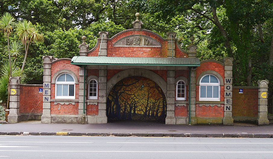
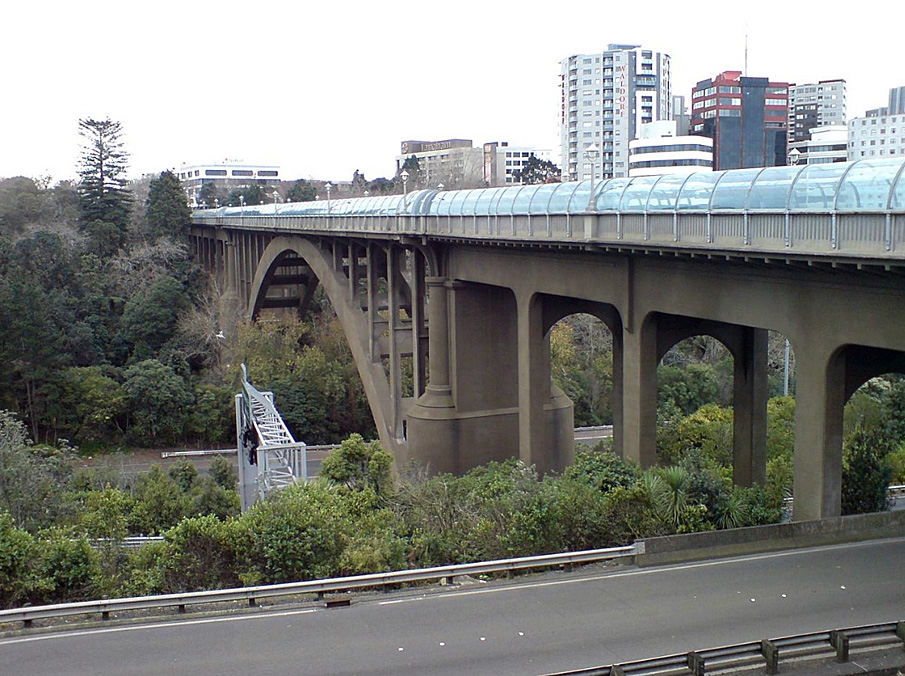
Sign up to hear more
Get the latest heritage news, features and events delivered
straight to your inbox.
