

The best description of the interrelationship between the port and surrounding businesses comes from a report to the Royal Commission of Inquiry into the Waterfront Industry which gives a description of the importance of the waterfront and the significance of the interrelated functions: 'The waterfront industry is a name for a set of operations carried out at a point where transport by land and transport by sea meet. The ramifications of these operations are widespread. The industry presents a scene of great activity with many occupations, all of which, however, are related more or less closely to the primary occupation of servicing ships and cargoes. These are Harbour Boards, ships chandlers, carriers, marine engineering works, stevedores, the Customs and many others.' Central to port operations was the 'loading and unloading of ships carrying cargoes of all types, sizes and shapes, and round this centre revolve all other occupations engaged on the waterfront.' The Otago Harbour Board provided wharves, wharf equipment and sheds and contracted stevedoring firms to handle overseas cargo to and from the ship's side. This excerpt provides the basis for the Historic Area.
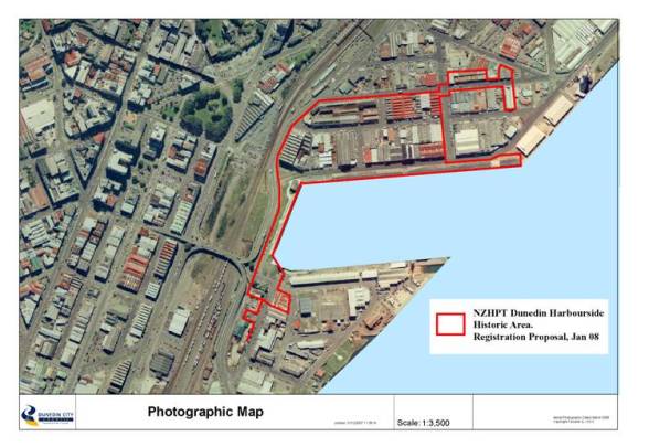
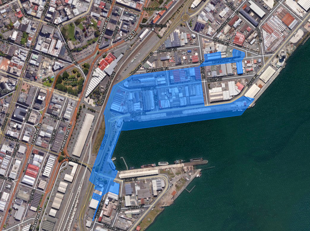
The Historic Area is based around the core of the Rattray Street and Cross wharves, and the land reclaimed by the early twentieth century. The wharves were the centre of the network of transport services reaching into the hinterland connecting with markets throughout the world. The businesses which developed around the harbour reflected the important requirements of trade and industry. The first significant building was a wool merchant's premises; the merchant was followed by engineering works which grew up to service both the shipping and gold mining industries. The pattern of businesses throughout the twentieth century reflected the changing trades, and also the social and economic climate of the times. The wharves were the centre of the significant workforce involved in handling cargo. Lumpers (also known as 'wharfies'), seamen, carters and harbour board staff members were important workers. The port functions shaped the buildings which grew up around the Steamer Basin - the Wharf Hotel, the British Sailors' Society Seafarers' Centre, the Otago Harbour Board Offices, the Waterside Workers' Hall, the Customs Department Wharf Office, and the wharves and wharf sheds. These places mirror the history of the area. The various stores in the vicinity of the harbour demonstrate the importance of the area as a transit point between transport links and markets.
The extent of registration reflects the development of the harbourside area, with its long history of engineering, manufacturing and warehousing, as well as services and structures associated with the operation and administration of the port. The extent includes the areas which had been largely reclaimed prior to 1900, and which had seen long term industrial development, and where significant structures remain providing a window into the histories of work at the harbourside.
A number of buildings do not contribute to the historic or architectural character of the harbourside. These are outlined in blue in the plan in volume 2. Any future development on these sites should be sympathetic to the surrounding heritage environment.
The look of the buildings reflects their uses. In particular the rhythms of the engineering works and the wharf sheds contribute to the overall look of the Historic Area. Some buildings have strong design qualities, for example the New Zealand Loan and Mercantile Agency Co. Building, the New Zealand Iron and Steel Co. Building, the Waterfront Industry Commission Administration Building and the British Sailors' Society Seafarers' Centre. In addition the views back to Troup's Railway Station, the Otago Settlers Museum and Queens Gardens are significant visual elements of the Historic Area.
KEY ELEMENTS OF THE HISTORIC AREA:
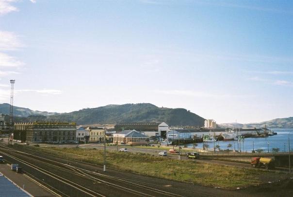
The Historic Area is based around the core of the port operations and associated businesses surrounding the Steamer Basin at the Upper Harbour in Dunedin which had developed by the first decades of the twentieth century. The Historic Area includes a major portion of the land in the vicinity of Rattray, Willis and Cresswell Streets. The Historic Area also includes the Fryatt Street and Cross Wharves, including the wharf sheds on Fryatt Street Wharf, as well as the former Otago Harbour Board Administration Building at the junction of Birch Street and Cross Wharves which surround the Steamer Basin, and the former British Sailors' Society Seafarers' Centre on the corner of Birch, Wharf and Roberts Streets, the former Briscoe's Wharf Store and Works on the corner of Birch and Roberts Streets, and the remaining walls and bridge abutment on Roberts Street.
The Steamer Basin sits at the eastern edge of the main business district of Dunedin City and has formed the focus of port activities since the nineteenth century. The Steamer Basin is bordered by wharves on three sides: Birch Street Wharf on the south, Cross Wharf on the west and Fryatt Street Wharf on the north. On the west the Steamer Basin is cut off from the city by the railway corridor which runs in a north/south direction, blocking the historic access routes to the wharf area which were via Jetty (now Birch) Street, Rattray, and Stuart Streets. These historic routes linked the wharves (the Stuart Street, Rattray Street and Jetty Street wharves) with the businesses in central Dunedin, illustrating the close ties that grew from the wealth of gold: the former company headquarters and remarkable warehouse buildings line the nearby streets. Stuart Street, Rattray Street and Jetty Street (now Mason, Fryatt and Birch Streets) provided a continuation of Charles Kettle's city plan, with these streets marking the extension of the grid. Subsequent road development realigns the industrial area surrounding the harbour with the railway line, providing a new axis for streets such as Thomas Burns Street.
The main areas of development in the nineteenth century sprang up around what was then Rattray Street Wharf, and, as reclamation allowed, spread north to the two adjoining blocks on Willis and Cresswell Streets. A mix of industrial, commercial and service businesses developed. From the construction of the first substantial building in the 1870s with the New Zealand Loan and Mercantile Agency Co. Ltd's premises, through to the consolidation of engineering firms in the twentieth century, these blocks have illustrated the mix of businesses representing the typical portside activities of the period.
Ports were the terminus of sea, land and rail transport. Ports drew around them the businesses necessary for their functioning: Harbour Board offices, warehouses and stores, cartage firms, engineering works, manufacturers, shipping agents, brokers, and stevedores as well as services for those people working the port - wharfies and seamen. The Historic Area recognises the core of the interrelated buildings and structures, which were established in the nineteenth century, and which developed and consolidated their activities in the twentieth century.
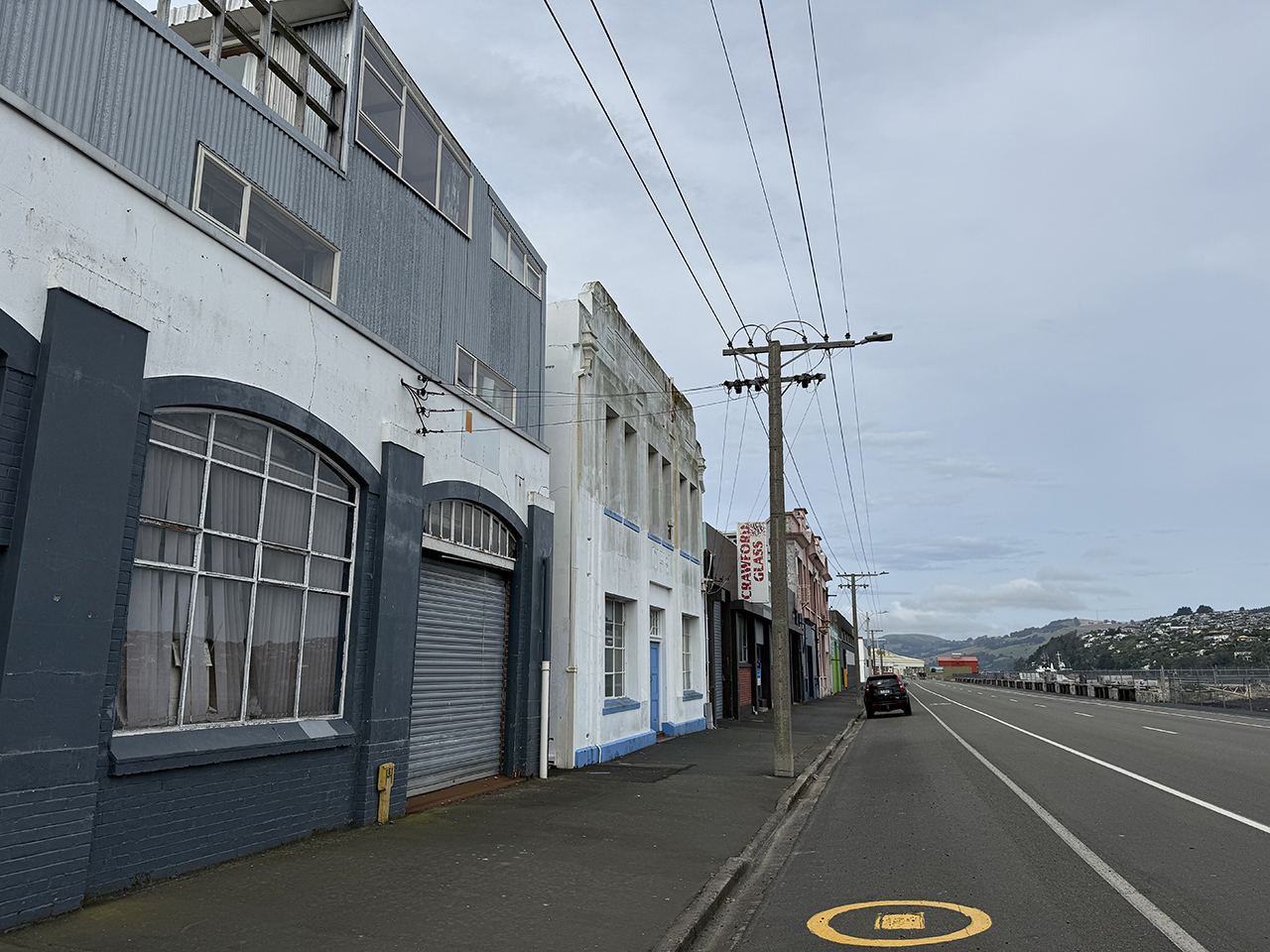
Fryatt Street and its buildings and structures are characterised by a mix of building styles, and they mostly line up with the edge of the street. On the south side the uniform rhythm of the concrete wharf sheds, with their sheltering overhangs backing onto the wide street allowing for loading and offloading of cargo, which provide a largely unbroken mass to the streetscape. The now largely underused wharf provides the physical and historical link to the once bustling sea-based trading links.
On the north side of Fryatt Street the buildings show a wide range of styles, representing the range of businesses which have operated there: the ornate Victorian New Zealand Loan and Mercantile Agency Co. Ltd building, which was first a woolstore, and later headquarters of an international merchant company forms the western boundary of the Historic Area; there is a smaller jumble of late nineteenth century and early twentieth century, largely two-storey brick buildings, which reflect the mixed businesses from that period. The mid-twentieth century is represented by dominating engineering workshop and offices of the Farra Co.
One block further back from the Steamer Basin is Willis Street. The south side of Willis Street between Thomas Burns and Fish Street sees the rear of the buildings fronting Fryatt Street, including the New Zealand Loan and Mercantile Agency Co. Ltd's premises, as well as the Farra Engineering buildings. Between these are some infill buildings which contribute to the character of the streetscape through their jumble of forms, rather than architectural merit. The block between Fish and Tewsley Streets is of a similar character: a mix of one and two storey business premises reflecting the historic range of businesses operating on these streets.
The blocks bounded by the north side of Willis Street and Cresswell Street are of a different character. In this part of the Historic Area whole blocks are characterised by a uniformity of style, reflecting the function of the buildings. The Farra engineering complex makes a significant contribution to the architecture of the area with its streamlined facades to both Willis and Cresswell Streets. The east end of the block shows more architectural variety, and illustrates the older buildings associated with the engineering companies which have occupied this site since the 1880s. The Salmond Reed report considers that twentieth century architecture makes a significant contribution to the streetscape, particularly the architecture associated with the engineering firms.
The block immediately to the east is occupied by another group of buildings associated with one function, also reflected in the uniformity of the architecture. These structures housed the Sargood, Son and Ewen boot and clothing factories from the 1880s up until the mid-twentieth century. The factory takes up almost the entire block and makes an outstanding architectural and historical contribution to the Historic Area.
Diagonally opposite the Sargood buildings, to the north east, are the 1924 Farra engineering premises, the first of that company on the harbourside. Farra Engineering has expanded to become the dominant business concern in the Historic Area. The 1924 brick buildings provide another important architectural and historical contribution to the Historic Area.
A little further to the east is the substantial brick warehouse constructed by the Otago Daily Times Company as a store. This building, designed to fit the uneven lot shape, with its gable cranked in the middle to match the shape of the lot, is notable. Immediately across the road is the former Massey Harris & Co. Store (known now as the Evening Star Store), another handsome brick building which makes a strong contribution to the streetscape.
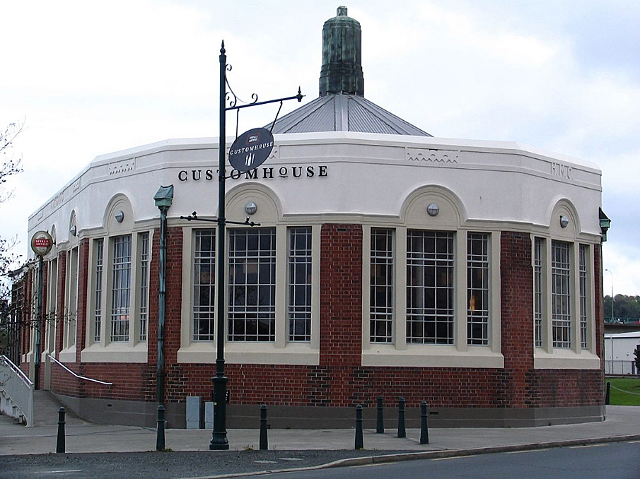
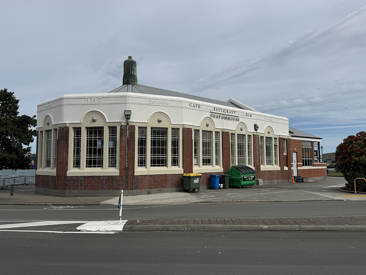
At the west end of the Steamer Basin the redeveloped Cross Wharf provides a focus for recreational activities, particularly fishing. The former Custom's Department Wharf Office, at the north end of Cross Wharf, has been redeveloped as an upmarket restaurant. The striking nautically-themed former Otago Harbour Board Administration Building sits on the junction of Cross and Birch Street wharves and is now home to commercial operations. To the south on the corner of Birch, Roberts and Wharf Streets, the former British Sailors' Society Seafarers' Centre, now houses another popular eatery, continuing to be a social centre on the waterfront. The former Briscoes Wharf Store and Works (circa 1910), on the corner of Birch and Roberts Streets, has a notable street front and windows, also makes a significant contribution to the streetscape. The historic link with the town is recalled through the remnant stone walls and abutment of the overbridge which linked the harbourside with the mercantile premises on Vogel Street.
The defining characteristic of the Dunedin Harbourside Historic Area is the interconnected nature of the history represented by the variety of activities carried out in the harbourside from the nineteenth century, and their development in the twentieth century. The streetscape that has developed reflects the consolidation of businesses, particularly engineering companies, as well as the rise and fall of businesses. The large engineering premises and the jumble of smaller premises give the streetscape its distinctive character, and while there are standout components within the Historic Area (listed in Appendix 1), it is the cumulative effect of the mix of style and form which contributes to its significance.
List Entry Information
Status
Listed
List Entry Status
Historic Area
Access
Private/No Public Access
List Number
7767
Date Entered
4th April 2008
Date of Effect
4th April 2008
City/District Council
Dunedin City
Region
Otago Region
Extent of List Entry
The Historic Area includes the land described Secs 1-2, 11-16, 18, 21-22, Pt secs 9-12, Blk XLVII Town of Dunedin; Lots 3-5 Deed Plan 423; Lots 1-3 DP 10210; Lots 1-2 DP 10292; Pt sec 1 and Pt sec 2, Secs 3-6, Pt secs 7-8 Blk LII, Town of Dunedin; Secs 14-15, 22, 25-26, Blk XLVIII Town of Dunedin; Pt sec 5 and Pt sec 6 Blk XLVIII Town of Dunedin; Lots 1-3 DP 7843; Lots 1-2 DP 26371; Lots 1-2 DP 21823; Lot 1 7989; Lots 1-2 DP 300344; Lot 1 DP 7678; Lots 1-2 and 4 DP 6375; Secs 1-6 Blk LXII Town of Dunedin; Secs 5-6, 7, 9 , 11, and 40-41 DP 1900; Lot 4 DP 15162, Lot 2 DP 9757; Lot 1 DP 7743; Sec 12 Blk LXIII, Pt Harbour Board Endowment and Pt DP 2055; Part of Lot 1 DP 22587 Otago Harbour, New Zealand Gazette 1930, p.2233.; Sec 36, Blk LXI Town of Dunedin; Legal Road: Fish Street, Willis Street, Cresswell Street, Fryatt Street, Birch Street, Roberts Street (where bridge walls are located). All legal descriptions are Otago Land District. (comprised in certificates of title OT242/297; OT184/224; OT288/74; OT288/61; OT288/82; OT19C/133; OTB1/293; OTB1/1281; OT288/71; OT18B/761; OT18B/762; OT13B/1467; 2235; 2236; OT373/110; OT13B/1466; 190522; OT244/266; OT363/175; OT288/111; OT67/233; OT416/56; OT416/53; 46556; 172074; 172075; OT116/202; OT416/54; 267008 (to be issued); OT3C/979; OT15B/108; 170482; 342357; OT372/216; OT373/231) and the buildings and structures thereon, including wharves and legal road.. The Historic Area is based around the core of the Rattray Street and Cross wharves, and the land reclaimed by the early twentieth century. The wharves were the centre of the network of transport services reaching into the hinterland connecting with markets throughout the world. The businesses which developed around the harbour reflected the important requirements of trade and industry. The first significant building was a wool merchant's premises; the merchant was followed by engineering works which grew up to service both the shipping and gold mining industries. The pattern of businesses throughout the twentieth century reflected the changing trades, and also the social and economic climate of the times. The wharves were the centre of the significant workforce involved in handling cargo. Lumpers (also known as 'wharfies'), seamen, carters and harbour board staff members were important workers. The port functions shaped the buildings which grew up around the Steamer Basin - the Wharf Hotel, the British Sailors' Society Seafarers' Centre, the Otago Harbour Board Offices, the Waterside Workers' Hall, the Customs Department Wharf Office, and the wharves and wharf sheds. These places mirror the history of the area. The various stores in the vicinity of the harbour demonstrate the importance of the area as a transit point between transport links and markets. The extent of registration reflects the development of the harbourside area, with its long history of engineering, manufacturing and warehousing, as well as services and structures associated with the operation and administration of the port. The extent includes the areas which had been largely reclaimed prior to 1900, and which had seen long term industrial development, and where significant structures remain providing a window into the histories of work at the harbourside.
Legal description
Secs 1-2, 11-16, 18, 21-22, Pt secs 9-12, Blk XLVII Town of Dunedin; Lots 3-5 Deed Plan 423; Lots 1-3 DP 10210; Lots 1-2 DP 10292; Pt sec 1 and Pt sec 2, Secs 3-6, Pt secs 7-8 Blk LII, Town of Dunedin; Secs 14-15, 22, 25-26, Blk XLVIII Town of Dunedin; Pt sec 5 and Pt sec 6 Blk XLVIII Town of Dunedin; Lots 1-3 DP 7843; Lots 1-2 DP 26371; Lots 1-2 DP 21823; Lot 1 DP 7989; Lots 1-2 DP 300344; Lot 1 DP 7678; Lots 1-2 and 4 DP 6375; Secs 1-6 Blk LXII Town of Dunedin; Secs 5-6, 7, 9 , 11, and 40-41 DP 1900; Lot 4 DP 15162, Lot 2 DP 9757; Lot 1 DP 7743; Sec 12 Blk LXIII, Pt Harbour Board Endowment and Pt DP 2055; Part of Lot 1 DP 22587 Otago Harbour, NZ Gazette 1930, p.2233.; Sec 36, Blk LXI Town of Dunedin; Legal Road: Fish Street, Willis Street, Cresswell Street, Fryatt Street, Birch Street, Roberts Street (where bridge walls are located). All legal descriptions are Otago Land District.
Why is this place significant?
Cultural Significance
SOCIAL SIGNIFICANCE OR VALUE: The Dunedin Harbourside Historic Area has social significance. The Wharves were an important place of social contact. The wharves were the workplace of a wide range of occupational groups, related to cargo handling functions and shipping - seamen and wharfies in particular. These occupations were well known for their ways of working and their relationship with the town. The wharfies' casual on-call work had particular requirements that were reflected in the services provided for them on the water area, and those that oversaw their work. The Waterside Workers' Hall and the Waterfront Industry Commission Administration Building reflect both the social and bureaucratic aspects of this important work. Seamen also had particular needs as transient workers: the need for points of contact and social support, reflected in the provision of the Seafarers' Centre by the British Sailors' Society. Of course other social contacts were available at the Wharf Hotel, an equally important social institution. The Wharf itself was also the social point of contact for visitors arriving in Dunedin by sea. The wharves provided recreational activity particularly for fishing, something that remains Cross Wharf's most prominent social use in 2007.
Historic Significance
Historical Significance or Value The Dunedin Harbourside Historic Area has historical significance. The Historic Area is based around the core of the wharves and the land reclaimed by the early twentieth century. The Wharves were the centre of the network of transport services reaching into the hinterland connecting with markets throughout the world. The businesses which developed around the harbour reflected the important requirements of trade and industry. The first substantial business was a wool merchant; it was followed by engineering works which grew up to service both the shipping and gold mining industries. The pattern of businesses throughout the twentieth century reflected the changing trades, and also the social and economic climate of the times. The wharves were the centre of the significant workforce involved in handling cargo, from wharfies, through to seamen, carters and harbour board staff. Their working lives were reflected in the buildings which grew up around the Steamer Basin - the Wharf Hotel, the British Sailors' Society Seafarers' Centre, the Otago Harbour Board Offices, the Waterside Workers' Hall, the Customs Department Wharf Office, and the Wharves and Wharf Sheds themselves. The stores around the harbour reflect its importance as a transit point between transport links and markets.
Physical Significance
AESTHETIC SIGNIFICANCE OR VALUE: The Dunedin Harbourside Historic Area has aesthetic significance. The design of the buildings in the Historic Area reflected their uses, and provides a visual quality to the Historic Area. The rhythm of form and windows of engineering works and the wharf sheds contributes to the overall impression. Some buildings have strong design qualities, for example, the New Zealand Loan and Mercantile Agency Co. Building, the New Zealand Iron and Steel Co. Building, the Waterfront Industry Commission Administration Building and the British Sailors' Society Seafarers' Centre. The visual links with Dunedin City, with views back to Troup's Railway Station, the Otago Settlers Museum and Queens Gardens, are a significant visual element to the Historic Area. ARCHITECTURAL SIGNIFICANCE OR VALUE: The Dunedin Harbourside Historic Area has architectural significance. The buildings within the Historic Area represent a range of building types and design ideas. They range from the ornate Victorian style of the New Zealand Loan and Mercantile Agency Co. Building through to the modernist Waterfront Industry Commission Administrative Building and the British Sailors' Society Seafarers' Centre. The utilitarian engineering works, factory buildings, stores, and wharf sheds, where form follows function, make a particular architectural contribution to the streetscape. Much of the development was small scale and ad hoc. This is reflected in the mainly small masonry buildings constructed at the street front, in keeping with the scale of the businesses operating within. There are also large areas of uniformity and larger scale design evident in the engineering works, the wharf sheds, and the Sargood, Son and Ewen premises, which reflect the larger scale concerns which developed. These developments give the Historic Area particular architectural character. TECHNOLOGICAL SIGNIFICANCE OR VALUE: The variety of buildings and structures in the Dunedin Harbourside Historic Area give it technological significance. Not only do the buildings, and structures such as the wharves themselves reflect different building technologies, but they also reflect the important technological developments associated with the businesses themselves, particularly in the area of engineering.
Otepoti is the Maori name for the Upper Harbour which, according to W.H.S. Roberts, refers to 'the place of the steep points' or 'where the points of land come together.' The harbour stretched from Taiaroa Head, where the narrow channel slipped between the sand spit at Aramoana and the headland, to the bush clad hills with the low lying shoreline sixteen kilometres distant. According to the Kai Tahu Natural Resource Management Plan the landscape of the Otago Harbour 'evokes a cultural and spiritual meaning to takata whenua signified through layers of tradition, association and use, reinforced by place names that individually reflect a myriad of traditions, events, ancestors, site use, food or other resources and cultural perspectives.' There emerged a 'stable, organised and united series of hapu located at permanent or semi-permanent settlements along the coast, with an intricate network of mahika kai rights and networks that relied to a large extent on coastal resources.' In the early nineteenth century the main settlements were found at the beaches and bays of the Lower Harbour where a few hundred Maori lived. From the early 1830s a settlement developed further at Otakou where George and Edward Weller established their whaling station. The Upper Harbour was not settled at that time but was visited for food gathering and as a thoroughfare for travellers. Edward Shortland, Protector of Aborigines, described the Upper Harbour in September 1843, noting the steep hills to the water's edge and the long mud flats visible at low tide. In April 1844 surveyor Frederick Tuckett, searching for a possible site for the proposed New Zealand Company Settlement of New Edinburgh admired the beauty of the harbour. He journeyed up the channel, where to his disappointment, there was no easy access to deep water. He identified Koputai (now Port Chalmers) as the best potential port site on the inlet , foreshadowing the competition between Dunedin and Port Chalmers for wharf and port services which would characterise the later nineteenth century history of the harbour. Tuckett's companion David Monro praised the harbour's perfect location with its nearly total shelter from the open sea, and room for a great number of vessels to moor and with plenty of available timber. In July 1844 Colonel Wakefield added is approval when he visited the harbour and ordered the entrance and channels to be marked. The optimism was premature. The New Edinburgh scheme foundered. Plans for organised immigration were not revived until early 1846 when the idea was reborn as the Otago Scheme. In 1846 Charles Kettle arrived to survey the Otago Block, and make the lower harbour safe for navigation by buoying the channel to Koputai. There was great optimism about the potential harbour at Koputai but less about the Upper Harbour. Port Chalmers seemed destined to be a commercial centre as the natural port in the harbour, and even at this early date the possible reclamation of areas of the Upper Harbour was considered. The first immigrant ships from the Otago Scheme arrived at Port Chalmers aboard the John Wickliffe in March 1848, with the Philip Laing following in March, with settlers' worldly belongs carried ashore on the backs of Maori boatmen at Dunedin. Wickliffe Pier was built near the landing place in 1848, but was dry at high tide. The settlers in Port Chalmers and Dunedin were is conflict almost right away over port services. The problems were obvious to settlers: people and goods landed at Port Chalmers and as there was no road, had to be transferred to small vessels and shipped to the Upper Harbour; landing was difficult there, even with the small jetty constructed during the first few months of settlement. Port Chalmers with its deep water access seemed a much more sensible location for settlement. An early reflection of the competition between Dunedin and Port Chalmers was the argument over the location of the Customs House built at Port Chalmers in 1848. Leading merchants petitioned the newly-formed Provincial Council for the service to be relocated to Dunedin. The petition was successful, confirming Dunedin as the centre for commercial interests, and the focus of the importing and distribution of goods in Otago. There was, however, little coastal traffic and little pressure for development. Coastal trade was sporadic and mainly serviced the whaling settlements along the south coast and provided berth for the occasional immigrant ship. With the decline in the whaling industry in the 1850s trade continued to fall away and the settlement of Otago progressed only slowly. There was little that the Provincial Council could do to develop the harbour as they had little revenue and many calls on their funds. The Council did move to control the harbour land, and in 1854, 450 acres of tidal land along the foreshore were set aside as an endowment for harbour development. The Council believed that as the town developed the foreshore would be needed for buildings and the rent on these properties would provide income for harbour works. An 1856 image shows the low lying foreshore land and mudflats to the south of Bell Hill with the 'Wickliffe Pier', as the first jetty was called, reaching out to deeper water, but making it only just past the mudflats at low tide. By the late 1850s sheep stations and farms had been established inland. Pastoralism led to an increase in port traffic. Steam traffic began to gain momentum by the end of the 1850s, revealing the limitations of the shallow harbour, with its difficult entry over the bar and the inadequate wharf facilities. The Provincial Council turned its attention to these problems, commissioning surveyor John Turnbull Thomson, who was in charge of organising the Land and Survey Department of the Provincial Government, to report on the situation. Then suddenly, in 1861, Otago changed forever. Even as the Provincial Council was debating the merits of steam dredges, reclamation, jetties, and cranes, prospector Gabriel Read was inland making his discovery which would change Otago forever. Read discovered gold in mid-1861 and by spring thousands of diggers poured into Otago; dozens of ships sat in the harbour and the port became the premier port in the country. The Provincial Council was now faced with inadequate harbour facilities in high demand. The Port of Otago became the busiest harbour in New Zealand, and the third most important in the Pacific. In 1861 there were very limited port facilities: there were no warehouses and only a small jetty unusable at low tide. In March 1862 work began on the new jetty at Rattray Street, the wharf was being enlarged at Port Chalmers, and the jetty at Pelichet Bay built. Another new jetty at Stuart Street was being developed by May 1862, planned to be 550 ft. long and 33 ft. wide. The Jetty Street pier was constructed to handle horse traffic at a cost of £7,000, but was already inadequate by 1863. The Provincial Council's attention turned to reclamation with an application to the General Government for a grant for land below the high water mark. The resulting Otago Harbour Trust Leasing Ordinance of 1862 made over to the Provincial Council 421 acres of foreshore below high-water mark, and opposite and adjacent to the town of Dunedin harbour improvements. The Council was able to lease out the land for up to 99 years and use the rent to pay for harbour developments. The Otago Harbour Loan Ordinance was passed in the same year, and the Council was able to issue debentures of up to £50,000 in total and use it to build docks and piers, and was also able to remove some fifty buildings on Bell Hill. The spoil from the removal of Bell Hill was to be used as fill for the reclamation. In October 1862 the Provincial Council instructed provincial engineer C.R. Swyer to prepare an estimate for the reclamation of 137 acres of foreshore, and the improvement of facilities for shipping. Swyer's scheme was based around reclaiming the land between the Stuart Street and Rattray Street jetties, replacing them with three docks with locks and swing bridges, at the cost of £355,305, the cost to be offset by the sale of the land. An 1863 image shows the demolition of Bell Hill underway and reclamation in the foreground of the picture, in what is now the Queens Gardens. The foreshore is still at the base of Bell Hill. Another image shows the light weight jetty and the wharf storage structures constructed on poles alongside. Swyer's scheme was judged too ambitious so the Provincial Council focused on the demolition of Bell Hill. The rock and rubble was sent down chutes onto the tidal flats and mixed with sand taken from the Tahuna sand hills. In March 1864 the first piece of reclaimed land (around Bond and Crawford Streets) was sold on 99 year leasehold at a rental of £1 per foot of street frontage. In 1864 the Government accepted a tender for a further fifteen-and-a-half acres of reclamation, south from the Old Jetty towards the Andersons Bay Road, linking to the Market Reserve. The new 500 ft.-long Rattray Street jetty was completed in March 1865 at a cost of £6,914. The jetty was designed to give 12 ft. of water at low tide, but in fact was almost dry at low tide, emphasising that sending long jetties out into the harbour to provide sufficient depth, was only a temporary solution. Debate turned to the respective merits of reclamation, deepening the harbour channel, or the construction of a rail connection with Port Chalmers. In 1867 the Government put £1,000 towards deepening the berth alongside the Rattray Street jetty. By September 1867 the channel was 220 ft. long and 26 ft. wide, and had been deepened by 5 ft. by prison labour, providing a depth of 6 ft. at low water. After a good deal of political manoeuvring a dredge was constructed. The New Era was launched in October 1867. It was first employed to deepen and widen the channels and approaches adjoining the Dunedin jetties. In anticipation of the increased wharf traffic the Provincial Government authorised the construction of wharf sheds for freight storage. The Dunedin-Port Chalmers railway was nearly completed by 1870, and a floating dock and graving dock had been constructed at Port Chalmers. The jetties in the Upper Harbour continued to silt up. Pushing the shoreline out into deeper water was again raised as a solution with heated debate over whether reclamation or dredging would solve silting problems. In March 1873 a Harbour Improvement Committee was set up and in July 1874 the Harbour Board met for the first time. The Board committed itself to a survey of the harbour, the dredging of a Dunedin-Port Chalmers channel, and the purchase of a steam tug and dredge, but found itself with insufficient funds. An image from the 1870s shows the advancement of the foreshore and the development of wharf structures resulting from the efforts of the Board. The wharves look more solid and the buildings on the foreshore are of greater substance. There are no structures on the wharf itself. A view back towards the city shows the progress of the reclamation with the widening area of fill adjoining the wharf, and the development of the Crawford Street frontage with its substantial buildings representing the kind of warehouses associated with the merchant businesses which flourished in Dunedin at this time. A plan from 1870 shows the extent of the reclamation and describes the work in progress: Rattray Street Jetty is being extended and a ‘Training Wall' stretches out beyond the Jetty itself; the tide mark sweeps along Fish Street and rails cut through the sections to the north of Willis Street; areas of blue shading show that there were still large areas of water or tidal land close to Castle Street; and Willis and lower Rattray Streets are only partially formed. A report completed by provincial engineer D.L. Simpson recommended further dredging. In recognition of the need for spoil disposal and for land near the wharves Simpson also recommended the reclamation of 422 acres of foreshore land at a total cost of £611,542. Simpson's report caused the Board great anxiety and led to a further commissioned work, this time from eminent Victorian engineer Major G. Gordon. Gordon recommended an even more expensive and extensive programme of works. As indecision followed the Board received many proposals offering solutions to the harbour problem, and finally, in June 1876, the Board decided to adopt Simpson's plan. The programme of major improvements was designed to make Dunedin the foremost port of New Zealand. By the 1870s Dunedin was the principal manufacturing centre of New Zealand. Local shipbuilders made the transition from wood, to iron and steel construction. Three companies, Kincaid & McQueen, R.S. Sparrow & Co., and John McGregor & Co., developed strong reputations as shipbuilders. In 1873 Kincaid and McQueen built a vessel from materials made entirely in Dunedin. In the 1870s and 1880s twelve steam ships were built in Dunedin. The Provincial Council was abolished in November 1876 and as a result the Harbour Board was also reorganised, and a new committee was set up to consider the issue of harbour improvements. The committee reported back to the Board in February 1877 noting the value of the reclamation (between Rattray and Jetty Streets), and also noting that a way ahead needed to be found, particularly in relation to the disposal of spoil from dredging. By the end of the 1870s images show how the facilities associated with the Rattray Street Wharf had developed. There were three round-roofed wharf sheds along Rattray Street Wharf, marked O and P (presumably Q on the end shed, which is obscured). A long shed ran perpendicular to these sheds on Cross Wharf, and a wharf stretched out from Jetty Street. Railway tracks were being laid at the edge of the reclaimed land. There was still water between Rattray Street and the photographer, indicating the work yet to be completed. The foreshore to the north of Rattray Street Wharf was yet to be reclaimed. In 1878 the city learned that the Government required the Crawford Street reserve for railway construction. The reserve ran from Andersons Bay Road to Lake Logan (now Logan Park). The Harbour Board felt its development plans were being marginalised. English marine engineer Sir John Coode along with the Colonial and District Engineers visited the harbour in April 1878, and reported their views, advising against extensive reclamation and supporting the use of the Crawford Street reserve for railway purposes. The Board was much taken aback and protested, arguing that the railway would cut the city off from the harbour. Against all objections, in August 1879, the Government took the disputed area. As late as 1880 reclamation remained limited and there were no businesses listed in street directories for the wharf area in 1880-1881. Occupation of the land adjoining Rattray Street Wharf was still relatively limited in the late 1880s. Street directories give an idea of the kind of businesses which had their premises close to the wharf. Stone's Directory indicates that on the right side of Rattray Street from the Upper Harbour were John Kennelly's Coal Pit Heath Coal Yard, the Brunner Coal Co.'s yard, mechanical engineer Joseph Sparrow's premises, William Ingram, ship and house plumber, brass founder and gasfitter's premises, the Wharf Hotel, W. Greggs & Co.'s coffee factory, and the New Zealand Loan and Mercantile Agency Co. Ltd.'s premises. One street back from the wharf on Willis Street, the only business operating is R.S. Sparrow & Co., an engineering and ship building firm. There are no other occupiers, indicating that the land further to the north was not reclaimed, or ready for occupation at this date. One of the early engineering concerns was Joseph Sparrow's Victoria Ironworks located next to the Wharf Hotel on Rattray Street. A description of Sparrow's engineering works provides an illustration of the kind of premises occupied by nineteenth century engineers. Scottish born Joseph Sparrow was apprenticed at the Leven Ship Yards, and also worked in iron ship building in both Glasgow and Newcastle on Tyne. Sparrow immigrated to New Zealand arriving aboard the William Davey in 1869. He was employed by engineers Kincaid and McQueen and at R.S. Sparrow's works, until starting his own business. The 1905 Cyclopedia records that Sparrow's works occupied ‘an acre and a half of freehold, and one eighth of an acre of leasehold land. The original building, an iron lean-to now only forms part of the engine house and coal shed....The blacksmith's part of the works is to be found in a brick building of one storey, which was added in 1882.' Sparrow had 12 blast forges, an eight and a half hundred weight steam hammer, 11 turning lathes and 16 vices and benches. An ‘iron building 160 by 100 feet' was used for boiler making, another large building was used as a pattern shop, and ‘large new moulding shop, which is built of iron is fitted with a three ton travelling crane, and contains two cupolas, mortar mill and other plant.' Sparrow had erected a store for patterns and for steel and iron. There was also a yard with a large tar bath for fluming and four derrick cranes. The company made machinery, including dredges, as well as general engineering and shipping. In 1880 the Otago Harbour Board annual report recorded an additional 1,200 ft. of berthage with the Jetty Street Wharf extension, the new Cross Wharf and 200 ft. of the Dock Wharf (known then as the Victoria Wharf) completed. The Pelichet Bay and Stuart Street Wharves were broken up for firewood in the late 1880s as they were incapable of handling modern trade. The roads laid out by the provincial government were cramping the space around the wharf sheds, and the growing size of both trade and ships made the limitations of even the new wharves evident. As a result of these concerns the Victoria Wharf, running off the end of the Rattray Street Wharf, and the Tongue Wharf were completed in four stages between 1883 and 1928. The labour force grew with the larger ships, and the increasing volume of cargo and trade. Many men worked for low pay in poor conditions. Discontent with their employment led to the first tide of industrial action at the Port. Historian Gavin McLean notes that neither the railways nor harbour board provided facilities for ‘lumpers', the unskilled labour force responsible for loading and unloading ships. Steam cranes were few, and horses were integral to waterfront work until after World War Two. The first Lumpers' Society was formed in the mid-1880s, and the first strike followed soon after, although the very limited action was centred in Port Chalmers rather than Dunedin. Dunedin did become a leader in labour matters: the Maritime Labour Council of New Zealand was formed in Dunedin in 1889 by John A. Millar, and within a year claimed to speak for over 16,000 workers. New Zealand's ‘first great strike' began at the Port of Otago on 26 August 1889 when the Wairarapa with a ‘non-union' crew came to berth, and the Port ground to a halt. By November the strike had collapsed, and the Maritime Labour Council no longer existed. The downturn of the 1880s heralded Dunedin's slow retreat from the business centre of New Zealand and slowed the already flagging development of the Upper Harbour. In February 1892 there were 27 acres of reclaimed land under lease, with a further 310 acres of reclamation planned, but little money to continue the work. Major traders were beginning to relocate their offices to other centres such as Wellington, and shipping companies such as the Shaw, Savill & Albion Co. indicated that unless problems with the Victoria Channel were resolved they would discharge their cargo at Port Chalmers. By the mid-1890s there were a cluster of businesses operating from the wharf area. On the right side of Rattray Street looking towards town were boat builder James Potter; coal merchants and stevedores John Mill & Co.; Q.V. Coal Co.; David Williams; engineer Joseph Sparrow; boot maker James McConnell; plumber William Ingram; the Wharf Hotel; tailors J. Watson & Co.; Greggs & Co. coffee factory; and the New Zealand Loan and Mercantile Agency Co. The importance of the railway is indicated by the presence of station master Arthur Thomas, Geddes and Hunter's railway refreshment rooms, and William Gilmour's bookstall near to the New Zealand Loan & Mercantile Agency Co., with the Dunedin Sailors' Home, Gibson & Co. carriers, and the railway goods office across the road. Willis Street had also developed by this date. Engineers Sparrow & Co. had expanded their business, now describing themselves as iron ship builders, boiler makers and iron and brass founders, as well as ‘manufacturers of all kinds of quartz crushing, pumping and winding machinery.' Sargood, Son and Ewen had built their boot factory next door. There were no businesses one further block north on Richardson Street perhaps indicating the incomplete reclamation of the area. New Harbour Board offices were opened in 1899. In the same year Cross Wharf was widened 15 ft. and dredged to allow a deep water berth. The following year the lower Jetty Street Wharf was also modernised. Three extensions were made to the Victoria Wharf between 1901 and 1904, making it 1,200 ft. in length, with 22 ft.-deep berths. Newer and wider wharf sheds were built and steam cranes installed. In 1900 there was renewed argument about the Railway Department's plans to locate the new railway station at the base of Stuart Street, closing off access to the wharves from the centre of town. A royal commission reported on the issue and in October 1901 endorsed the Railway Department's plans: the foundation for George Troup's new station was laid in June 1904. The Railway Department's encroachments on the Harbour Board's endowment again raised the central problem of reclamation. Up until the turn of the century reclamation had been undertaken spasmodically. The downturn in Dunedin's economic fortunes meant the reclaimed land was not returning the hoped-for revenue. Sections on the landward side of the railway reserve returned far better rental for the Harbour Board than those seaward, revenue was important to the Board. Connected to the Board's financial return was the problem of access to the harbour. In mid 1908 a public meeting demanded the construction of an overbridge between the city and the waterfront to get around the barrier posed by railway corridor. The Railway Department agreed and provision was made for an overbridge at the southern end of the reclaimed land, the remains of which are still evident on Robert and Wharf Streets. In 1905 new engineer J. Blair Mason put forward plans for further development of the Upper Harbour to meet the requirements of modern shipping. He called for new wharves and sheds, the concentration of trade in the Steamer Basin, and the widening of Rattray and Jetty Streets as well as a new tongue wharf to replace the existing decaying structure. He also recommended that the warehouses and wharf cranes be modernised. The existing wharf sheds were inadequate. New sheds were built: the ‘S' shed in 1910, and the ‘R' shed in 1911. These were about 200 ft. long and 50 ft. wide, and constructed from reinforced concrete. The wharves were widened and lit by 1910, and electric cranes were installed. The depth of Victoria Channel, and consequently, the limit to the size of ships which could access the Upper Harbour, remained an issue. Further development of the harbour area is indicated in the street directories. The 1905 Stone's Directory mentions the structures on the wharf itself: the Harbour Board offices; the Harbour Master's office; the Union Steam Ship Co.'s jetty office; import and export sheds; and the tide gauge office. Across the road Rattray Street now boasted businesses additional to those present in the mid-1890s: J Speight & Co.'s wharf cellarage; Laidlaw and Gray's store; timber and general merchants Hogg & Co. Ltd.; mantelpiece manufacturer George McIntosh; Henry Guthrie Coal Merchants; and the Westport Coal Co. Ltd. Willis Street was occupied by The Dunedin Engineering Co. (Thomas and John Stevenson) and Sargood, Son and Ewen's clothing factory. On Richardson Street were a carter and Sargood, Son and Ewen's boot and felt hat factory. On the north side of Richardson Street were houses occupied by a police constable, harbour waterman, clerk, labourer, railway guard and sign writer among others. Further to the north Stuart Street (now Mason Street) was being developed, with mainly commercial premises, including engineers McGregor & Co., James McPherson shipwright and boat builder, and fish curer Charles Georgeson. In 1910 the same small business premises remained, with the addition of the Turner Brothers (wool and skin merchants), oil and soap manufacturers Usherwood & Co., wool exporter James Wilson, shipping agent and stevedoring company Keith Ramsay Ltd.'s store, the National Electric and Engineer Co.'s workshop, and dyer Sydney Hart. While the Willis Street occupants remained the same, Richardson Street had several new businesses: Engineers Laidlaw & Gray had relocated their premises from Rattray Street; Tasmanian hardwood and timber merchants McDougall & Co. had established their business; Massey-Harris had built their store; and William Robertson's wholesale fish and oyster merchant business had established premises. There were over 15 residences. Tewsley Street also seems to have some residences, with a labourer, journeyman boot maker and lumper, living on this street. A 1913 image shows that the current form of the streets around the Rattray Street Wharf had been established. The blocks between Rattray and Cresswell Streets show a dense collection of mainly industrial buildings. The most prominent buildings are the goods sheds running alongside Cross Wharf adjoining the railway line: they stretch out past the entire length of Cross Wharf. Across Rattray Street at the northern end of the goods sheds is the New Zealand Loan and Mercantile Agency Co. building which takes up the entire block fronting Thomas Burns Street. Single storey sheds are spaced along Rattray Street Wharf. While many of the buildings beyond the New Zealand Loan and Mercantile Agency Co. are obscured, smoking chimney stacks show the industries in the block between Rattray and Willis Streets with a cluster of mainly single-gabled shed-like buildings. The block further back between Willis and Richardson Streets also has well-established industrial premises: on the eastern end of the block is the Dunedin Engineering & Steel Co. Ltd.'s compound, with its chimney stack, small cluster of single storey sheds on Thomas Burns Street, and its larger two-and-a-half storey buildings on the Willis Street frontage. The block between Willis and Bombay Streets has terraced houses on its northern side, backed by what look to be storage or commercial premises on the south side of that block fronting Richardson Street. A mix of residential and commercial premises extends one block further. Beyond these three blocks to the north of the Rattray Street wharf the reclamation is still in progress, and the area appears still to be tidal. In 1913 there was further labour unrest in the harbour area. Industrial action in support of events in the North Island resulted in workers being shut out from Birch Street Wharf and Cross Wharf, with ‘specials' taking the place of the striking workers, a ten day lock out, at high cost to both workers and the Board. An image from the strike shows crowds assembled behind the Cross Wharf sheds to observe cargo handling. Further disruption occurred with the outbreak of World War One in 1914. Trans-Tasman and coastal services were disrupted and arrivals fell steeply. By 1917 fewer ships were calling than at any time since 1900, and the harbour works slowed at a similar rate. By the end of the war the effect was clear, historian Gavin McLean writes: ‘The war had been won but in truth there was little else to celebrate. The war had reduced the Port of Otago to a depressed backwater and 1919 dawned with its fortunes at their lowest ebb. Cranes towered like tombstones above the wharves practically devoid of shipping, the great reclamation projects lay abandoned and half-finished...and worst of all, the board's revenue had fallen dramatically.' After the war the businesses surrounding the harbour were relatively unchanged. The only new additions across the road from the Rattray Street wharf were Wilson & Canham Ltd., exporters of hides, sheep and rabbit skins, The Iron & Steel Co. of New Zealand Ltd. and carting contractor James Mulholland. The advance of unionism is illustrated by the presence of a number of labour unions occupying a single building next to the Sailors' Rest. The Unions included the Otago Motor and Horse Drivers Union, and the Storeman's Union. On Richardson Street the Maoriland Importing Co. (timber importers) had established their premises amidst the residential area. On Willis Street seed merchants Nimmo & Blair had their store, the Woolnough Window Co., and the Otago Dairy Co. had also established their businesses. The stagnation of the war and the general feeling of decay changed when J. McGregor Wilkie was appointed engineer in June 1918. Wilkie's work programme formed the basis of the harbour development until 1940 and included the renewal of the Birch Street Wharf, the extension of the Victoria Wharf and its connection with the railway system, the construction of a free store (with provision for a cool store), and the provision of a new shed on the Rattray Street Wharf with new cargo handling equipment. The Victoria Ironworks remained one of the largest businesses in the area. By the 1920s Sparrow's firm specialised in the ‘construction of tin and gold dredging machinery, plants for steel constructional work, sugar and milk machinery, large steam pumps, vacuum pumps, rice and oat shelling machinery, and any work of similar nature.' The Company had ten blast forges, heavy pneumatic hammers, turning lathes, vertical drilling machines, as well as milling and planing machines, plate bending rollers, and an eight-ton travelling crane, and three cupolas. There was a 100 ft. square iron building devoted to boiler making. In the 1930s Joseph Sparrow & Sons was involved in fabricating large structures, including a bridge at Wharekuri over the Waitaki River, over 640 ft. in length, one of the largest road spans in New Zealand at that time. By the 1930s the wharf area seems to be characterised by fewer but larger business premises. On Rattray Street was Paterson & Co.'s machinery store, Spencer and Dunckley's store, carters M. Stevenson Ltd.'s store, insulation manufacturers Salmac Ltd., Joseph Sparrow and Sons, Wilson Canham & Co., the National Distributors Ltd., the Otago Skin Co., and Turner Bros. The labour movement was represented by the Dunedin and Port Chalmers Co-operative Labour Employment Association with Otto Loll as secretary. The Waterside Workers' Hall was built by the Otago Harbour Board in 1937. Farra Bros., tinsmiths and galvanisers, had their premises on Tewsley Street between Mason and Richardson Streets, and the Divisional Headquarters of the Royal Naval Volunteer Reserve was on Tewsley Street. After the 1930s there was a consolidation of businesses. Some smaller premises were demolished and larger structures built, particularly for the engineering companies. A 1930s image, for example, shows a number of cleared sites on the Tewsley, Rattray and Fish Street block, while the Dunedin Engineering & Steel Co.'s premises remain a small single-storey collection of buildings with adjoining yards. The early war period saw the formation of the Waterfront Control Commission created in 1940 to control the loading and unloading of cargo in the war years, and which from 1954, when premises were built on Willis Street, maintained an overseeing presence on the waterfront for the next thirty years. The Harbour Board faced the downturn and stagnation which resulted from the shortages and rationing associated with World War Two. The consolidation of business is evident in 1940. On Rattray Street are the Spencer and Dunckley's Store, the Waterside Workers' Hall, Salmac Insulation Ltd., Turner Brothers, Sparrow and Sons, carter James Mulholland, the Wharf Hotel, Spencer and Dunckley's carting depot, Black skin buyer and exporter and the New Zealand Loan and Mercantile Agency Co. building. On Richardson Street in addition to Sargood's boot and felt hat factory, were the National Mortgage and Agency Co.'s bag-making department, Carl Ball & Co.'s wool and skin merchants, H.V. Haddock Ltd.'s timber yard, Massey Harris & Co., and the Otago Harbour Board store. The Otago Daily Times store was located at the harbour end of Richardson Street. After the war many streets in the Historic Area renamed: Lower Rattray Street became Fryatt Street; Richardson Street became Cresswell Street; the lower curve of Rattray Street, which had been variously named on plans as Coates Terrace, Queens Crescent and Victoria Crescent, became a continuation of Fryatt Street. As late as the 1950s the buildings in the waterfront area remained a mix of architectural styles representing the uneven development of the area. In 1956 the General Manager of the Otago Harbour Board wrote that many of the buildings ‘are of timber construction, with corrugated iron roofs. They are a heterogeneous collection, having been added to and patched up from time to time. For the most part they are well over 50 years old and in a dilapidated condition.' By the late 1950s there was a further consolidation of the businesses in the waterfront, with engineering firms well established in the area, along with storage or yard facilities for various companies. Sparrow's Victoria Ironworks were taken over by Fletcher Steel and Engineering, and Sparrow's premises demolished. New offices and workshops erected. In the 1950s Fletcher Steel comprised a number of companies throughout the country including Dunedin firms Joseph Sparrow & Sons Ltd. and Stevenson & Cook Engineering Co. Ltd. While trade did recover after World War Two further difficulties followed. In 1951 industrial relations deteriorated and the watersiders played a key part in the militant action that followed. In August 1950 a dispute over the handling of lamp-black tied up five ports, including Dunedin and the government declared a state of emergency. In February 1951 relations between watersiders and employers broke down, and watersiders not prepared to work overtime were dismissed. In March harsh measures were taken against workers, and the armed services took over the wharf work. At the end of March the Harbour Board Employees' Union returned to work, strike breakers supplemented the work of the armed services, and by the middle of May new unions sympathetic to the government took over from the military. The labour movement was left divided. The Commission of Inquiry into the unrest reveals something of the conditions and work patterns at the harbour. The Commission were told that the largest group of waterside workers were those who handled the cargo of ships on the wharves and in the nearby transit sheds. Workers were engaged as casuals on jobs to which they were allocated by a central labour control office known as ‘The Bureau.' They were employed in a gang, with numbers tied to the amount and type of cargo being handled. The workers were members of an industrial union made up of mainly workers registered at the port labour bureau, with the union acting as their agents in employment matters. Prior to the waterfront industrial upheaval the local unions were branches of the New Zealand Waterside Workers' Industrial Union of Workers, but after the unrest, that union ceased functioning, and separate port unions became autonomous. The history of labour on the waterfront is represented by the workplace itself (wharves and sheds) as well as the former Waterside Workers' Hall on Fryatt Street, and the former Waterfront Industry Commission Administration Building on Willis Street. The period from the late 1930s through to the 1960s saw much discussion and debate about the merit of developing an indigenous, possibly state-owned iron and steel industry based on the Nelson region's Onekaka iron ore deposits. Dunedin's engineering industries putting in a call for a plant sited at Aramoana. While ultimately this much-lauded proposal came to nothing, the nature of Dunedin's engineering companies formed the basis for the argument presented to the government. Dunedin's engineering heritage was promoted as second to none, built on the inheritance of early shipping and gold dredging. Dunedin companies supplied much of the country with its engineering requirements, with the fullest range of operations in the country in one place: three of the country's five steel foundries (two of which were the harbour-based Dunedin Engineering & Steel Co. and Wilkinson Callon Ltd.), five major fabricating shops, a number of smaller fabricating shops, and six iron foundries. A 1961 photograph shows the harbour area and the prominence of the engineering industry. The Harbour Board offices sit in the foreground, a two-storey brick building on the corner of Cross and Birch Street wharves. Long low single storey sheds sit on Cross Wharf bordering the railway line. On the Fryatt Street Wharf there are two long single-gabled sheds. Behind the wharves on Fryatt Street the large Farra engineering shed has been built. The layout of the blocks behind the wharves is characterised by substantial industrial buildings. The Dunedin Engineering & Steel Co. Ltd. occupied their premises in the 1960s, and in 1969 amalgamated with Farra Brothers, to become Farra Dunedin Engineering Ltd. The Farra group of companies is the largest occupier of land in the Historic Area. The development of containerised shipping in the 1960s changed the waterfront largely emptying it of the bustle of small-scale shipping trade. The expense of operating container ports meant that only a limited number could be supported in New Zealand. In the early 1970s Port Chalmers was confirmed as the second South Island container port after Lyttelton. Dunedin's Upper Harbour declined as a result. The Harbour Board modernised its accommodation. A new administration building was designed by Ashley Muir of Mason and Wales (who had designed the award winning administration and amenities building at Port Chalmers). The building stands over the water on steel piles at the corner of the Birch Street and Cross Wharves. It has mirrored glass walls and funnel-shaped roof appendages, as well as a gangway connecting it with the wharf. The Harbour Board moved into its new premises in February 1982. The old building was demolished to make way for a landscaped car park. In 1983 the new offices won a National Design Award. By the 1980s the Dunedin wharves were largely deserted in comparison with the bustling container port at Port Chalmers: the Kitchener and Rattray Street wharves were no longer used for cargo-handling; Birch Street Wharf and the X and Y berth of the Victoria Wharf were used by the fishing industry. Gavin McLean identified the future use of the ‘redundant and deteriorating Rattray Street Wharf and its sheds, as well as the complete redevelopment of its old commercial district between Victoria Wharf and the railway line', as one of Dunedin's, and the Harbour Board's, ongoing concerns. ‘Its banks, mills and business houses dominated the small national economy and in consequence the Port of Otago became the leading importing centre, serving not only the province but the rest of New Zealand as well...That pre-eminence started to slip away from the late 1880s onwards. Bracken's ‘lovely maiden seated in a grotto by the shore' was by the 1920s a decrepit old dowager, smelling faintly of mothballs and faded dreams. The port declined as an importing centre as more and more Dunedin companies expanded their North Island operations and moved their headquarters northwards.' In the first decade of the twenty-first century the question of the future of the area around the Steamer Basin remains significant. The Dunedin City Council's consultation with residents and businesses on options for Dunedin's future in 2001 indicated that the future of the harbour and access were important to people. In 2003 Dunedin City Council commissioned an urban design competition for Dunedin harbourside, attracting three urban design practices to develop concepts for redevelopment. The Council and landowner Chalmers Properties used these proposals to develop a long term vision for the area, and in 2003 agreed to work on a master plan. In 2005 Salmond Reed Architects were commissioned to investigate the heritage values of the harbourside area. Salmond Reed's report for Chalmers Properties Ltd. notes that the area includes fine examples of nineteenth century industrial architecture, and recognised the particular value of brick masonry construction in the area. Salmond Reed identified the particular character of the streetscape, referring to the ‘wide mix of building styles and character, which have in common a general consistency of scale, and a general tendency to be aligned with the street edge', as well as the wide street width contributing to the feeling of the area. The report noted that the area is largely industrial, with activities ranging from engineering, through to warehousing, transport depots and other services which contribute to the character of the area. The report saw ‘the setting of the buildings' as a ‘key ingredient of the character of the precinct. The wide streets have an unusually generous spatial quality which is an integral ingredient of the Harbour Side area.' Salmond Reed concluded that ‘Harbour Side is an area of distinctive character, and that the physical framework for that character is worthy of preservation. It is important as a collection of some very good, but otherwise generally modest buildings. Their value is significantly enhanced as a group, and for common historic themes of maritime service, warehousing and freight handling.' In July/August 2005 The Dunedin City Council and Chalmers Properties Ltd. put out the ‘Harbourside Stakeholder Consultation Document.' The Council wanted to investigate opportunities to revitalise the harbourside and reconnect it with the central city. The document represented the preliminary thinking working alongside landowners and Port Otago Ltd. The report recognises the history of reclamation, and the originally strong link between the city and the harbour, weakened by the railway corridor. The report recognises the character of the area, with its industrial buildings, including port warehousing, and the main concentration of buildings between the Steamer Basin and Mason Street. A number of buildings are recognised as heritage value. The wharf area lost further focus as a business centre with the closure of the Otakou Fisheries' wharf and processing facilities in late 2006. In October 2006 the Dunedin City Council and Chalmers Properties Ltd. released a further ‘Harbourside Consultation Document.' The document outlined their thinking about the future of the Harbour area. The report recorded that there had been a survey to identify heritage, and that ‘a number of buildings have been identified with significant architectural or historical features that are worthy of protection.' Fewer heritage buildings were identified in the ‘Harbourside Consultation Document' than in the 2005 ‘Harbourside Stakeholder Consultation Document.' In 2007 the dominant industry remains the Farra engineering group of companies, along with smaller light industrial- or transport-related functions. There has been a revival of social activity in the area with the continued operation of the Wharf Hotel, and restaurants opening in both the former wharf offices of the Customs Department and the former British Sailors' Society Seafarer's Centre. The redeveloped Cross Wharf attracts those interested in recreational fishing, and the city end of the Fryatt Street Wharf attracts visitors as the starting point for harbour tours aboard the Monarch.
Otepoti is the Maori name for the Upper Harbour which, according to W.H.S. Roberts, refers to 'the place of the steep points' or 'where the points of land come together.' The harbour stretched from Taiaroa Head, where the narrow channel slipped between the sand spit at Aramoana and the headland, to the bush clad hills with the low lying shoreline sixteen kilometres distant. According to the Kai Tahu Natural Resource Management Plan the landscape of the Otago Harbour 'evokes a cultural and spiritual meaning to takata whenua signified through layers of tradition, association and use, reinforced by place names that individually reflect a myriad of traditions, events, ancestors, site use, food or other resources and cultural perspectives.' There emerged a 'stable, organised and united series of hapu located at permanent or semi-permanent settlements along the coast, with an intricate network of mahika kai rights and networks that relied to a large extent on coastal resources.' In the early nineteenth century the main settlements were found at the beaches and bays of the Lower Harbour where a few hundred Maori lived. From the early 1830s a settlement developed further at Otakou where George and Edward Weller established their whaling station. The Upper Harbour was not settled at that time but was visited for food gathering and as a thoroughfare for travellers. Edward Shortland, Protector of Aborigines, described the Upper Harbour in September 1843, noting the steep hills to the water's edge and the long mud flats visible at low tide. In April 1844 surveyor Frederick Tuckett, searching for a possible site for the proposed New Zealand Company Settlement of New Edinburgh admired the beauty of the harbour. He journeyed up the channel, where to his disappointment, there was no easy access to deep water. He identified Koputai (now Port Chalmers) as the best potential port site on the inlet , foreshadowing the competition between Dunedin and Port Chalmers for wharf and port services which would characterise the later nineteenth century history of the harbour. Tuckett's companion David Monro praised the harbour's perfect location with its nearly total shelter from the open sea, and room for a great number of vessels to moor and with plenty of available timber. In July 1844 Colonel Wakefield added is approval when he visited the harbour and ordered the entrance and channels to be marked. The optimism was premature. The New Edinburgh scheme foundered. Plans for organised immigration were not revived until early 1846 when the idea was reborn as the Otago Scheme. In 1846 Charles Kettle arrived to survey the Otago Block, and make the lower harbour safe for navigation by buoying the channel to Koputai. There was great optimism about the potential harbour at Koputai but less about the Upper Harbour. Port Chalmers seemed destined to be a commercial centre as the natural port in the harbour, and even at this early date the possible reclamation of areas of the Upper Harbour was considered. The first immigrant ships from the Otago Scheme arrived at Port Chalmers aboard the John Wickliffe in March 1848, with the Philip Laing following in March, with settlers' worldly belongs carried ashore on the backs of Maori boatmen at Dunedin. Wickliffe Pier was built near the landing place in 1848, but was dry at high tide. The settlers in Port Chalmers and Dunedin were is conflict almost right away over port services. The problems were obvious to settlers: people and goods landed at Port Chalmers and as there was no road, had to be transferred to small vessels and shipped to the Upper Harbour; landing was difficult there, even with the small jetty constructed during the first few months of settlement. Port Chalmers with its deep water access seemed a much more sensible location for settlement. An early reflection of the competition between Dunedin and Port Chalmers was the argument over the location of the Customs House built at Port Chalmers in 1848. Leading merchants petitioned the newly-formed Provincial Council for the service to be relocated to Dunedin. The petition was successful, confirming Dunedin as the centre for commercial interests, and the focus of the importing and distribution of goods in Otago. There was, however, little coastal traffic and little pressure for development. Coastal trade was sporadic and mainly serviced the whaling settlements along the south coast and provided berth for the occasional immigrant ship. With the decline in the whaling industry in the 1850s trade continued to fall away and the settlement of Otago progressed only slowly. There was little that the Provincial Council could do to develop the harbour as they had little revenue and many calls on their funds. The Council did move to control the harbour land, and in 1854, 450 acres of tidal land along the foreshore were set aside as an endowment for harbour development. The Council believed that as the town developed the foreshore would be needed for buildings and the rent on these properties would provide income for harbour works. An 1856 image shows the low lying foreshore land and mudflats to the south of Bell Hill with the 'Wickliffe Pier', as the first jetty was called, reaching out to deeper water, but making it only just past the mudflats at low tide. By the late 1850s sheep stations and farms had been established inland. Pastoralism led to an increase in port traffic. Steam traffic began to gain momentum by the end of the 1850s, revealing the limitations of the shallow harbour, with its difficult entry over the bar and the inadequate wharf facilities. The Provincial Council turned its attention to these problems, commissioning surveyor John Turnbull Thomson, who was in charge of organising the Land and Survey Department of the Provincial Government, to report on the situation. Then suddenly, in 1861, Otago changed forever. Even as the Provincial Council was debating the merits of steam dredges, reclamation, jetties, and cranes, prospector Gabriel Read was inland making his discovery which would change Otago forever. Read discovered gold in mid-1861 and by spring thousands of diggers poured into Otago; dozens of ships sat in the harbour and the port became the premier port in the country. The Provincial Council was now faced with inadequate harbour facilities in high demand. The Port of Otago became the busiest harbour in New Zealand, and the third most important in the Pacific. In 1861 there were very limited port facilities: there were no warehouses and only a small jetty unusable at low tide. In March 1862 work began on the new jetty at Rattray Street, the wharf was being enlarged at Port Chalmers, and the jetty at Pelichet Bay built. Another new jetty at Stuart Street was being developed by May 1862, planned to be 550 ft. long and 33 ft. wide. The Jetty Street pier was constructed to handle horse traffic at a cost of £7,000, but was already inadequate by 1863. The Provincial Council's attention turned to reclamation with an application to the General Government for a grant for land below the high water mark. The resulting Otago Harbour Trust Leasing Ordinance of 1862 made over to the Provincial Council 421 acres of foreshore below high-water mark, and opposite and adjacent to the town of Dunedin harbour improvements. The Council was able to lease out the land for up to 99 years and use the rent to pay for harbour developments. The Otago Harbour Loan Ordinance was passed in the same year, and the Council was able to issue debentures of up to £50,000 in total and use it to build docks and piers, and was also able to remove some fifty buildings on Bell Hill. The spoil from the removal of Bell Hill was to be used as fill for the reclamation. In October 1862 the Provincial Council instructed provincial engineer C.R. Swyer to prepare an estimate for the reclamation of 137 acres of foreshore, and the improvement of facilities for shipping. Swyer's scheme was based around reclaiming the land between the Stuart Street and Rattray Street jetties, replacing them with three docks with locks and swing bridges, at the cost of £355,305, the cost to be offset by the sale of the land. An 1863 image shows the demolition of Bell Hill underway and reclamation in the foreground of the picture, in what is now the Queens Gardens. The foreshore is still at the base of Bell Hill. Another image shows the light weight jetty and the wharf storage structures constructed on poles alongside. Swyer's scheme was judged too ambitious so the Provincial Council focused on the demolition of Bell Hill. The rock and rubble was sent down chutes onto the tidal flats and mixed with sand taken from the Tahuna sand hills. In March 1864 the first piece of reclaimed land (around Bond and Crawford Streets) was sold on 99 year leasehold at a rental of £1 per foot of street frontage. In 1864 the Government accepted a tender for a further fifteen-and-a-half acres of reclamation, south from the Old Jetty towards the Andersons Bay Road, linking to the Market Reserve. The new 500 ft.-long Rattray Street jetty was completed in March 1865 at a cost of £6,914. The jetty was designed to give 12 ft. of water at low tide, but in fact was almost dry at low tide, emphasising that sending long jetties out into the harbour to provide sufficient depth, was only a temporary solution. Debate turned to the respective merits of reclamation, deepening the harbour channel, or the construction of a rail connection with Port Chalmers. In 1867 the Government put £1,000 towards deepening the berth alongside the Rattray Street jetty. By September 1867 the channel was 220 ft. long and 26 ft. wide, and had been deepened by 5 ft. by prison labour, providing a depth of 6 ft. at low water. After a good deal of political manoeuvring a dredge was constructed. The New Era was launched in October 1867. It was first employed to deepen and widen the channels and approaches adjoining the Dunedin jetties. In anticipation of the increased wharf traffic the Provincial Government authorised the construction of wharf sheds for freight storage. The Dunedin-Port Chalmers railway was nearly completed by 1870, and a floating dock and graving dock had been constructed at Port Chalmers. The jetties in the Upper Harbour continued to silt up. Pushing the shoreline out into deeper water was again raised as a solution with heated debate over whether reclamation or dredging would solve silting problems. In March 1873 a Harbour Improvement Committee was set up and in July 1874 the Harbour Board met for the first time. The Board committed itself to a survey of the harbour, the dredging of a Dunedin-Port Chalmers channel, and the purchase of a steam tug and dredge, but found itself with insufficient funds. An image from the 1870s shows the advancement of the foreshore and the development of wharf structures resulting from the efforts of the Board. The wharves look more solid and the buildings on the foreshore are of greater substance. There are no structures on the wharf itself. A view back towards the city shows the progress of the reclamation with the widening area of fill adjoining the wharf, and the development of the Crawford Street frontage with its substantial buildings representing the kind of warehouses associated with the merchant businesses which flourished in Dunedin at this time. A plan from 1870 shows the extent of the reclamation and describes the work in progress: Rattray Street Jetty is being extended and a ‘Training Wall' stretches out beyond the Jetty itself; the tide mark sweeps along Fish Street and rails cut through the sections to the north of Willis Street; areas of blue shading show that there were still large areas of water or tidal land close to Castle Street; and Willis and lower Rattray Streets are only partially formed. A report completed by provincial engineer D.L. Simpson recommended further dredging. In recognition of the need for spoil disposal and for land near the wharves Simpson also recommended the reclamation of 422 acres of foreshore land at a total cost of £611,542. Simpson's report caused the Board great anxiety and led to a further commissioned work, this time from eminent Victorian engineer Major G. Gordon. Gordon recommended an even more expensive and extensive programme of works. As indecision followed the Board received many proposals offering solutions to the harbour problem, and finally, in June 1876, the Board decided to adopt Simpson's plan. The programme of major improvements was designed to make Dunedin the foremost port of New Zealand. By the 1870s Dunedin was the principal manufacturing centre of New Zealand. Local shipbuilders made the transition from wood, to iron and steel construction. Three companies, Kincaid & McQueen, R.S. Sparrow & Co., and John McGregor & Co., developed strong reputations as shipbuilders. In 1873 Kincaid and McQueen built a vessel from materials made entirely in Dunedin. In the 1870s and 1880s twelve steam ships were built in Dunedin. The Provincial Council was abolished in November 1876 and as a result the Harbour Board was also reorganised, and a new committee was set up to consider the issue of harbour improvements. The committee reported back to the Board in February 1877 noting the value of the reclamation (between Rattray and Jetty Streets), and also noting that a way ahead needed to be found, particularly in relation to the disposal of spoil from dredging. By the end of the 1870s images show how the facilities associated with the Rattray Street Wharf had developed. There were three round-roofed wharf sheds along Rattray Street Wharf, marked O and P (presumably Q on the end shed, which is obscured). A long shed ran perpendicular to these sheds on Cross Wharf, and a wharf stretched out from Jetty Street. Railway tracks were being laid at the edge of the reclaimed land. There was still water between Rattray Street and the photographer, indicating the work yet to be completed. The foreshore to the north of Rattray Street Wharf was yet to be reclaimed. In 1878 the city learned that the Government required the Crawford Street reserve for railway construction. The reserve ran from Andersons Bay Road to Lake Logan (now Logan Park). The Harbour Board felt its development plans were being marginalised. English marine engineer Sir John Coode along with the Colonial and District Engineers visited the harbour in April 1878, and reported their views, advising against extensive reclamation and supporting the use of the Crawford Street reserve for railway purposes. The Board was much taken aback and protested, arguing that the railway would cut the city off from the harbour. Against all objections, in August 1879, the Government took the disputed area. As late as 1880 reclamation remained limited and there were no businesses listed in street directories for the wharf area in 1880-1881. Occupation of the land adjoining Rattray Street Wharf was still relatively limited in the late 1880s. Street directories give an idea of the kind of businesses which had their premises close to the wharf. Stone's Directory indicates that on the right side of Rattray Street from the Upper Harbour were John Kennelly's Coal Pit Heath Coal Yard, the Brunner Coal Co.'s yard, mechanical engineer Joseph Sparrow's premises, William Ingram, ship and house plumber, brass founder and gasfitter's premises, the Wharf Hotel, W. Greggs & Co.'s coffee factory, and the New Zealand Loan and Mercantile Agency Co. Ltd.'s premises. One street back from the wharf on Willis Street, the only business operating is R.S. Sparrow & Co., an engineering and ship building firm. There are no other occupiers, indicating that the land further to the north was not reclaimed, or ready for occupation at this date. One of the early engineering concerns was Joseph Sparrow's Victoria Ironworks located next to the Wharf Hotel on Rattray Street. A description of Sparrow's engineering works provides an illustration of the kind of premises occupied by nineteenth century engineers. Scottish born Joseph Sparrow was apprenticed at the Leven Ship Yards, and also worked in iron ship building in both Glasgow and Newcastle on Tyne. Sparrow immigrated to New Zealand arriving aboard the William Davey in 1869. He was employed by engineers Kincaid and McQueen and at R.S. Sparrow's works, until starting his own business. The 1905 Cyclopedia records that Sparrow's works occupied ‘an acre and a half of freehold, and one eighth of an acre of leasehold land. The original building, an iron lean-to now only forms part of the engine house and coal shed....The blacksmith's part of the works is to be found in a brick building of one storey, which was added in 1882.' Sparrow had 12 blast forges, an eight and a half hundred weight steam hammer, 11 turning lathes and 16 vices and benches. An ‘iron building 160 by 100 feet' was used for boiler making, another large building was used as a pattern shop, and ‘large new moulding shop, which is built of iron is fitted with a three ton travelling crane, and contains two cupolas, mortar mill and other plant.' Sparrow had erected a store for patterns and for steel and iron. There was also a yard with a large tar bath for fluming and four derrick cranes. The company made machinery, including dredges, as well as general engineering and shipping. In 1880 the Otago Harbour Board annual report recorded an additional 1,200 ft. of berthage with the Jetty Street Wharf extension, the new Cross Wharf and 200 ft. of the Dock Wharf (known then as the Victoria Wharf) completed. The Pelichet Bay and Stuart Street Wharves were broken up for firewood in the late 1880s as they were incapable of handling modern trade. The roads laid out by the provincial government were cramping the space around the wharf sheds, and the growing size of both trade and ships made the limitations of even the new wharves evident. As a result of these concerns the Victoria Wharf, running off the end of the Rattray Street Wharf, and the Tongue Wharf were completed in four stages between 1883 and 1928. The labour force grew with the larger ships, and the increasing volume of cargo and trade. Many men worked for low pay in poor conditions. Discontent with their employment led to the first tide of industrial action at the Port. Historian Gavin McLean notes that neither the railways nor harbour board provided facilities for ‘lumpers', the unskilled labour force responsible for loading and unloading ships. Steam cranes were few, and horses were integral to waterfront work until after World War Two. The first Lumpers' Society was formed in the mid-1880s, and the first strike followed soon after, although the very limited action was centred in Port Chalmers rather than Dunedin. Dunedin did become a leader in labour matters: the Maritime Labour Council of New Zealand was formed in Dunedin in 1889 by John A. Millar, and within a year claimed to speak for over 16,000 workers. New Zealand's ‘first great strike' began at the Port of Otago on 26 August 1889 when the Wairarapa with a ‘non-union' crew came to berth, and the Port ground to a halt. By November the strike had collapsed, and the Maritime Labour Council no longer existed. The downturn of the 1880s heralded Dunedin's slow retreat from the business centre of New Zealand and slowed the already flagging development of the Upper Harbour. In February 1892 there were 27 acres of reclaimed land under lease, with a further 310 acres of reclamation planned, but little money to continue the work. Major traders were beginning to relocate their offices to other centres such as Wellington, and shipping companies such as the Shaw, Savill & Albion Co. indicated that unless problems with the Victoria Channel were resolved they would discharge their cargo at Port Chalmers. By the mid-1890s there were a cluster of businesses operating from the wharf area. On the right side of Rattray Street looking towards town were boat builder James Potter; coal merchants and stevedores John Mill & Co.; Q.V. Coal Co.; David Williams; engineer Joseph Sparrow; boot maker James McConnell; plumber William Ingram; the Wharf Hotel; tailors J. Watson & Co.; Greggs & Co. coffee factory; and the New Zealand Loan and Mercantile Agency Co. The importance of the railway is indicated by the presence of station master Arthur Thomas, Geddes and Hunter's railway refreshment rooms, and William Gilmour's bookstall near to the New Zealand Loan & Mercantile Agency Co., with the Dunedin Sailors' Home, Gibson & Co. carriers, and the railway goods office across the road. Willis Street had also developed by this date. Engineers Sparrow & Co. had expanded their business, now describing themselves as iron ship builders, boiler makers and iron and brass founders, as well as ‘manufacturers of all kinds of quartz crushing, pumping and winding machinery.' Sargood, Son and Ewen had built their boot factory next door. There were no businesses one further block north on Richardson Street perhaps indicating the incomplete reclamation of the area. New Harbour Board offices were opened in 1899. In the same year Cross Wharf was widened 15 ft. and dredged to allow a deep water berth. The following year the lower Jetty Street Wharf was also modernised. Three extensions were made to the Victoria Wharf between 1901 and 1904, making it 1,200 ft. in length, with 22 ft.-deep berths. Newer and wider wharf sheds were built and steam cranes installed. In 1900 there was renewed argument about the Railway Department's plans to locate the new railway station at the base of Stuart Street, closing off access to the wharves from the centre of town. A royal commission reported on the issue and in October 1901 endorsed the Railway Department's plans: the foundation for George Troup's new station was laid in June 1904. The Railway Department's encroachments on the Harbour Board's endowment again raised the central problem of reclamation. Up until the turn of the century reclamation had been undertaken spasmodically. The downturn in Dunedin's economic fortunes meant the reclaimed land was not returning the hoped-for revenue. Sections on the landward side of the railway reserve returned far better rental for the Harbour Board than those seaward, revenue was important to the Board. Connected to the Board's financial return was the problem of access to the harbour. In mid 1908 a public meeting demanded the construction of an overbridge between the city and the waterfront to get around the barrier posed by railway corridor. The Railway Department agreed and provision was made for an overbridge at the southern end of the reclaimed land, the remains of which are still evident on Robert and Wharf Streets. In 1905 new engineer J. Blair Mason put forward plans for further development of the Upper Harbour to meet the requirements of modern shipping. He called for new wharves and sheds, the concentration of trade in the Steamer Basin, and the widening of Rattray and Jetty Streets as well as a new tongue wharf to replace the existing decaying structure. He also recommended that the warehouses and wharf cranes be modernised. The existing wharf sheds were inadequate. New sheds were built: the ‘S' shed in 1910, and the ‘R' shed in 1911. These were about 200 ft. long and 50 ft. wide, and constructed from reinforced concrete. The wharves were widened and lit by 1910, and electric cranes were installed. The depth of Victoria Channel, and consequently, the limit to the size of ships which could access the Upper Harbour, remained an issue. Further development of the harbour area is indicated in the street directories. The 1905 Stone's Directory mentions the structures on the wharf itself: the Harbour Board offices; the Harbour Master's office; the Union Steam Ship Co.'s jetty office; import and export sheds; and the tide gauge office. Across the road Rattray Street now boasted businesses additional to those present in the mid-1890s: J Speight & Co.'s wharf cellarage; Laidlaw and Gray's store; timber and general merchants Hogg & Co. Ltd.; mantelpiece manufacturer George McIntosh; Henry Guthrie Coal Merchants; and the Westport Coal Co. Ltd. Willis Street was occupied by The Dunedin Engineering Co. (Thomas and John Stevenson) and Sargood, Son and Ewen's clothing factory. On Richardson Street were a carter and Sargood, Son and Ewen's boot and felt hat factory. On the north side of Richardson Street were houses occupied by a police constable, harbour waterman, clerk, labourer, railway guard and sign writer among others. Further to the north Stuart Street (now Mason Street) was being developed, with mainly commercial premises, including engineers McGregor & Co., James McPherson shipwright and boat builder, and fish curer Charles Georgeson. In 1910 the same small business premises remained, with the addition of the Turner Brothers (wool and skin merchants), oil and soap manufacturers Usherwood & Co., wool exporter James Wilson, shipping agent and stevedoring company Keith Ramsay Ltd.'s store, the National Electric and Engineer Co.'s workshop, and dyer Sydney Hart. While the Willis Street occupants remained the same, Richardson Street had several new businesses: Engineers Laidlaw & Gray had relocated their premises from Rattray Street; Tasmanian hardwood and timber merchants McDougall & Co. had established their business; Massey-Harris had built their store; and William Robertson's wholesale fish and oyster merchant business had established premises. There were over 15 residences. Tewsley Street also seems to have some residences, with a labourer, journeyman boot maker and lumper, living on this street. A 1913 image shows that the current form of the streets around the Rattray Street Wharf had been established. The blocks between Rattray and Cresswell Streets show a dense collection of mainly industrial buildings. The most prominent buildings are the goods sheds running alongside Cross Wharf adjoining the railway line: they stretch out past the entire length of Cross Wharf. Across Rattray Street at the northern end of the goods sheds is the New Zealand Loan and Mercantile Agency Co. building which takes up the entire block fronting Thomas Burns Street. Single storey sheds are spaced along Rattray Street Wharf. While many of the buildings beyond the New Zealand Loan and Mercantile Agency Co. are obscured, smoking chimney stacks show the industries in the block between Rattray and Willis Streets with a cluster of mainly single-gabled shed-like buildings. The block further back between Willis and Richardson Streets also has well-established industrial premises: on the eastern end of the block is the Dunedin Engineering & Steel Co. Ltd.'s compound, with its chimney stack, small cluster of single storey sheds on Thomas Burns Street, and its larger two-and-a-half storey buildings on the Willis Street frontage. The block between Willis and Bombay Streets has terraced houses on its northern side, backed by what look to be storage or commercial premises on the south side of that block fronting Richardson Street. A mix of residential and commercial premises extends one block further. Beyond these three blocks to the north of the Rattray Street wharf the reclamation is still in progress, and the area appears still to be tidal. In 1913 there was further labour unrest in the harbour area. Industrial action in support of events in the North Island resulted in workers being shut out from Birch Street Wharf and Cross Wharf, with ‘specials' taking the place of the striking workers, a ten day lock out, at high cost to both workers and the Board. An image from the strike shows crowds assembled behind the Cross Wharf sheds to observe cargo handling. Further disruption occurred with the outbreak of World War One in 1914. Trans-Tasman and coastal services were disrupted and arrivals fell steeply. By 1917 fewer ships were calling than at any time since 1900, and the harbour works slowed at a similar rate. By the end of the war the effect was clear, historian Gavin McLean writes: ‘The war had been won but in truth there was little else to celebrate. The war had reduced the Port of Otago to a depressed backwater and 1919 dawned with its fortunes at their lowest ebb. Cranes towered like tombstones above the wharves practically devoid of shipping, the great reclamation projects lay abandoned and half-finished...and worst of all, the board's revenue had fallen dramatically.' After the war the businesses surrounding the harbour were relatively unchanged. The only new additions across the road from the Rattray Street wharf were Wilson & Canham Ltd., exporters of hides, sheep and rabbit skins, The Iron & Steel Co. of New Zealand Ltd. and carting contractor James Mulholland. The advance of unionism is illustrated by the presence of a number of labour unions occupying a single building next to the Sailors' Rest. The Unions included the Otago Motor and Horse Drivers Union, and the Storeman's Union. On Richardson Street the Maoriland Importing Co. (timber importers) had established their premises amidst the residential area. On Willis Street seed merchants Nimmo & Blair had their store, the Woolnough Window Co., and the Otago Dairy Co. had also established their businesses. The stagnation of the war and the general feeling of decay changed when J. McGregor Wilkie was appointed engineer in June 1918. Wilkie's work programme formed the basis of the harbour development until 1940 and included the renewal of the Birch Street Wharf, the extension of the Victoria Wharf and its connection with the railway system, the construction of a free store (with provision for a cool store), and the provision of a new shed on the Rattray Street Wharf with new cargo handling equipment. The Victoria Ironworks remained one of the largest businesses in the area. By the 1920s Sparrow's firm specialised in the ‘construction of tin and gold dredging machinery, plants for steel constructional work, sugar and milk machinery, large steam pumps, vacuum pumps, rice and oat shelling machinery, and any work of similar nature.' The Company had ten blast forges, heavy pneumatic hammers, turning lathes, vertical drilling machines, as well as milling and planing machines, plate bending rollers, and an eight-ton travelling crane, and three cupolas. There was a 100 ft. square iron building devoted to boiler making. In the 1930s Joseph Sparrow & Sons was involved in fabricating large structures, including a bridge at Wharekuri over the Waitaki River, over 640 ft. in length, one of the largest road spans in New Zealand at that time. By the 1930s the wharf area seems to be characterised by fewer but larger business premises. On Rattray Street was Paterson & Co.'s machinery store, Spencer and Dunckley's store, carters M. Stevenson Ltd.'s store, insulation manufacturers Salmac Ltd., Joseph Sparrow and Sons, Wilson Canham & Co., the National Distributors Ltd., the Otago Skin Co., and Turner Bros. The labour movement was represented by the Dunedin and Port Chalmers Co-operative Labour Employment Association with Otto Loll as secretary. The Waterside Workers' Hall was built by the Otago Harbour Board in 1937. Farra Bros., tinsmiths and galvanisers, had their premises on Tewsley Street between Mason and Richardson Streets, and the Divisional Headquarters of the Royal Naval Volunteer Reserve was on Tewsley Street. After the 1930s there was a consolidation of businesses. Some smaller premises were demolished and larger structures built, particularly for the engineering companies. A 1930s image, for example, shows a number of cleared sites on the Tewsley, Rattray and Fish Street block, while the Dunedin Engineering & Steel Co.'s premises remain a small single-storey collection of buildings with adjoining yards. The early war period saw the formation of the Waterfront Control Commission created in 1940 to control the loading and unloading of cargo in the war years, and which from 1954, when premises were built on Willis Street, maintained an overseeing presence on the waterfront for the next thirty years. The Harbour Board faced the downturn and stagnation which resulted from the shortages and rationing associated with World War Two. The consolidation of business is evident in 1940. On Rattray Street are the Spencer and Dunckley's Store, the Waterside Workers' Hall, Salmac Insulation Ltd., Turner Brothers, Sparrow and Sons, carter James Mulholland, the Wharf Hotel, Spencer and Dunckley's carting depot, Black skin buyer and exporter and the New Zealand Loan and Mercantile Agency Co. building. On Richardson Street in addition to Sargood's boot and felt hat factory, were the National Mortgage and Agency Co.'s bag-making department, Carl Ball & Co.'s wool and skin merchants, H.V. Haddock Ltd.'s timber yard, Massey Harris & Co., and the Otago Harbour Board store. The Otago Daily Times store was located at the harbour end of Richardson Street. After the war many streets in the Historic Area renamed: Lower Rattray Street became Fryatt Street; Richardson Street became Cresswell Street; the lower curve of Rattray Street, which had been variously named on plans as Coates Terrace, Queens Crescent and Victoria Crescent, became a continuation of Fryatt Street. As late as the 1950s the buildings in the waterfront area remained a mix of architectural styles representing the uneven development of the area. In 1956 the General Manager of the Otago Harbour Board wrote that many of the buildings ‘are of timber construction, with corrugated iron roofs. They are a heterogeneous collection, having been added to and patched up from time to time. For the most part they are well over 50 years old and in a dilapidated condition.' By the late 1950s there was a further consolidation of the businesses in the waterfront, with engineering firms well established in the area, along with storage or yard facilities for various companies. Sparrow's Victoria Ironworks were taken over by Fletcher Steel and Engineering, and Sparrow's premises demolished. New offices and workshops erected. In the 1950s Fletcher Steel comprised a number of companies throughout the country including Dunedin firms Joseph Sparrow & Sons Ltd. and Stevenson & Cook Engineering Co. Ltd. While trade did recover after World War Two further difficulties followed. In 1951 industrial relations deteriorated and the watersiders played a key part in the militant action that followed. In August 1950 a dispute over the handling of lamp-black tied up five ports, including Dunedin and the government declared a state of emergency. In February 1951 relations between watersiders and employers broke down, and watersiders not prepared to work overtime were dismissed. In March harsh measures were taken against workers, and the armed services took over the wharf work. At the end of March the Harbour Board Employees' Union returned to work, strike breakers supplemented the work of the armed services, and by the middle of May new unions sympathetic to the government took over from the military. The labour movement was left divided. The Commission of Inquiry into the unrest reveals something of the conditions and work patterns at the harbour. The Commission were told that the largest group of waterside workers were those who handled the cargo of ships on the wharves and in the nearby transit sheds. Workers were engaged as casuals on jobs to which they were allocated by a central labour control office known as ‘The Bureau.' They were employed in a gang, with numbers tied to the amount and type of cargo being handled. The workers were members of an industrial union made up of mainly workers registered at the port labour bureau, with the union acting as their agents in employment matters. Prior to the waterfront industrial upheaval the local unions were branches of the New Zealand Waterside Workers' Industrial Union of Workers, but after the unrest, that union ceased functioning, and separate port unions became autonomous. The history of labour on the waterfront is represented by the workplace itself (wharves and sheds) as well as the former Waterside Workers' Hall on Fryatt Street, and the former Waterfront Industry Commission Administration Building on Willis Street. The period from the late 1930s through to the 1960s saw much discussion and debate about the merit of developing an indigenous, possibly state-owned iron and steel industry based on the Nelson region's Onekaka iron ore deposits. Dunedin's engineering industries putting in a call for a plant sited at Aramoana. While ultimately this much-lauded proposal came to nothing, the nature of Dunedin's engineering companies formed the basis for the argument presented to the government. Dunedin's engineering heritage was promoted as second to none, built on the inheritance of early shipping and gold dredging. Dunedin companies supplied much of the country with its engineering requirements, with the fullest range of operations in the country in one place: three of the country's five steel foundries (two of which were the harbour-based Dunedin Engineering & Steel Co. and Wilkinson Callon Ltd.), five major fabricating shops, a number of smaller fabricating shops, and six iron foundries. A 1961 photograph shows the harbour area and the prominence of the engineering industry. The Harbour Board offices sit in the foreground, a two-storey brick building on the corner of Cross and Birch Street wharves. Long low single storey sheds sit on Cross Wharf bordering the railway line. On the Fryatt Street Wharf there are two long single-gabled sheds. Behind the wharves on Fryatt Street the large Farra engineering shed has been built. The layout of the blocks behind the wharves is characterised by substantial industrial buildings. The Dunedin Engineering & Steel Co. Ltd. occupied their premises in the 1960s, and in 1969 amalgamated with Farra Brothers, to become Farra Dunedin Engineering Ltd. The Farra group of companies is the largest occupier of land in the Historic Area. The development of containerised shipping in the 1960s changed the waterfront largely emptying it of the bustle of small-scale shipping trade. The expense of operating container ports meant that only a limited number could be supported in New Zealand. In the early 1970s Port Chalmers was confirmed as the second South Island container port after Lyttelton. Dunedin's Upper Harbour declined as a result. The Harbour Board modernised its accommodation. A new administration building was designed by Ashley Muir of Mason and Wales (who had designed the award winning administration and amenities building at Port Chalmers). The building stands over the water on steel piles at the corner of the Birch Street and Cross Wharves. It has mirrored glass walls and funnel-shaped roof appendages, as well as a gangway connecting it with the wharf. The Harbour Board moved into its new premises in February 1982. The old building was demolished to make way for a landscaped car park. In 1983 the new offices won a National Design Award. By the 1980s the Dunedin wharves were largely deserted in comparison with the bustling container port at Port Chalmers: the Kitchener and Rattray Street wharves were no longer used for cargo-handling; Birch Street Wharf and the X and Y berth of the Victoria Wharf were used by the fishing industry. Gavin McLean identified the future use of the ‘redundant and deteriorating Rattray Street Wharf and its sheds, as well as the complete redevelopment of its old commercial district between Victoria Wharf and the railway line', as one of Dunedin's, and the Harbour Board's, ongoing concerns. ‘Its banks, mills and business houses dominated the small national economy and in consequence the Port of Otago became the leading importing centre, serving not only the province but the rest of New Zealand as well...That pre-eminence started to slip away from the late 1880s onwards. Bracken's ‘lovely maiden seated in a grotto by the shore' was by the 1920s a decrepit old dowager, smelling faintly of mothballs and faded dreams. The port declined as an importing centre as more and more Dunedin companies expanded their North Island operations and moved their headquarters northwards.' In the first decade of the twenty-first century the question of the future of the area around the Steamer Basin remains significant. The Dunedin City Council's consultation with residents and businesses on options for Dunedin's future in 2001 indicated that the future of the harbour and access were important to people. In 2003 Dunedin City Council commissioned an urban design competition for Dunedin harbourside, attracting three urban design practices to develop concepts for redevelopment. The Council and landowner Chalmers Properties used these proposals to develop a long term vision for the area, and in 2003 agreed to work on a master plan. In 2005 Salmond Reed Architects were commissioned to investigate the heritage values of the harbourside area. Salmond Reed's report for Chalmers Properties Ltd. notes that the area includes fine examples of nineteenth century industrial architecture, and recognised the particular value of brick masonry construction in the area. Salmond Reed identified the particular character of the streetscape, referring to the ‘wide mix of building styles and character, which have in common a general consistency of scale, and a general tendency to be aligned with the street edge', as well as the wide street width contributing to the feeling of the area. The report noted that the area is largely industrial, with activities ranging from engineering, through to warehousing, transport depots and other services which contribute to the character of the area. The report saw ‘the setting of the buildings' as a ‘key ingredient of the character of the precinct. The wide streets have an unusually generous spatial quality which is an integral ingredient of the Harbour Side area.' Salmond Reed concluded that ‘Harbour Side is an area of distinctive character, and that the physical framework for that character is worthy of preservation. It is important as a collection of some very good, but otherwise generally modest buildings. Their value is significantly enhanced as a group, and for common historic themes of maritime service, warehousing and freight handling.' In July/August 2005 The Dunedin City Council and Chalmers Properties Ltd. put out the ‘Harbourside Stakeholder Consultation Document.' The Council wanted to investigate opportunities to revitalise the harbourside and reconnect it with the central city. The document represented the preliminary thinking working alongside landowners and Port Otago Ltd. The report recognises the history of reclamation, and the originally strong link between the city and the harbour, weakened by the railway corridor. The report recognises the character of the area, with its industrial buildings, including port warehousing, and the main concentration of buildings between the Steamer Basin and Mason Street. A number of buildings are recognised as heritage value. The wharf area lost further focus as a business centre with the closure of the Otakou Fisheries' wharf and processing facilities in late 2006. In October 2006 the Dunedin City Council and Chalmers Properties Ltd. released a further ‘Harbourside Consultation Document.' The document outlined their thinking about the future of the Harbour area. The report recorded that there had been a survey to identify heritage, and that ‘a number of buildings have been identified with significant architectural or historical features that are worthy of protection.' Fewer heritage buildings were identified in the ‘Harbourside Consultation Document' than in the 2005 ‘Harbourside Stakeholder Consultation Document.' In 2007 the dominant industry remains the Farra engineering group of companies, along with smaller light industrial- or transport-related functions. There has been a revival of social activity in the area with the continued operation of the Wharf Hotel, and restaurants opening in both the former wharf offices of the Customs Department and the former British Sailors' Society Seafarer's Centre. The redeveloped Cross Wharf attracts those interested in recreational fishing, and the city end of the Fryatt Street Wharf attracts visitors as the starting point for harbour tours aboard the Monarch.
Physical Description and Analysis Relationship between Historic Places: The best description of the interrelationship between the port and surrounding businesses comes from a report to the Royal Commission of Inquiry into the Waterfront Industry which gives a description of the importance of the waterfront and the significance of the interrelated functions: 'The waterfront industry is a name for a set of operations carried out at a point where transport by land and transport by sea meet. The ramifications of these operations are widespread. The industry presents a scene of great activity with many occupations, all of which, however, are related more or less closely to the primary occupation of servicing ships and cargoes. These are Harbour Boards, ships chandlers, carriers, marine engineering works, stevedores, the Customs and many others.' Central to port operations was the 'loading and unloading of ships carrying cargoes of all types, sizes and shapes, and round this centre revolve all other occupations engaged on the waterfront. The Otago Harbour Board provided wharves, wharf equipment and sheds and contracted stevedoring firms to handle overseas cargo to and from the ship's side. This excerpt provides the basis for the Historic Area. Key Elements of the Historic Area: The Historic Area is based around the core of the port operations and associated businesses surrounding the Steamer Basin at the Upper Harbour in Dunedin which had developed by the first decades of the twentieth century. The Historic Area includes a major portion of the land in the vicinity of Rattray, Willis and Cresswell Streets. The Historic Area also includes the Fryatt Street and Cross Wharves, including the wharf sheds on Fryatt Street Wharf, as well as the former Otago Harbour Board Administration Building at the junction of Birch Street and Cross Wharves which surround the Steamer Basin, and the former British Sailors' Society Seafarers' Centre on the corner of Birch, Wharf and Roberts Streets, the former Briscoe's Wharf Store and Works on the corner of Birch and Roberts Streets, and the remaining walls and bridge abutment on Roberts Street. The Steamer Basin sits at the eastern edge of the main business district of Dunedin City and has formed the focus of port activities since the nineteenth century. The Steamer Basin is bordered by wharves on three sides: Birch Street Wharf on the south, Cross Wharf on the west and Fryatt Street Wharf on the north. On the west the Steamer Basin is cut off from the city by the railway corridor which runs in a north/south direction, blocking the historic access routes to the wharf area which were via Jetty (now Birch) Street, Rattray, and Stuart Streets. These historic routes linked the wharves (the Stuart Street, Rattray Street and Jetty Street wharves) with the businesses in central Dunedin, illustrating the close ties that grew from the wealth of gold: the former company headquarters and remarkable warehouse buildings line the nearby streets. Stuart Street, Rattray Street and Jetty Street (now Mason, Fryatt and Birch Streets) provided a continuation of Charles Kettle's city plan, with these streets marking the extension of the grid. Subsequent road development realigns the industrial area surrounding the harbour with the railway line, providing a new axis for streets such as Thomas Burns Street. The main areas of development in the nineteenth century sprang up around what was then Rattray Street Wharf, and, as reclamation allowed, spread north to the two adjoining blocks on Willis and Cresswell Streets. A mix of industrial, commercial and service businesses developed. From the construction of the first substantial building in the 1870s with the New Zealand Loan and Mercantile Agency Co. Ltd's premises, through to the consolidation of engineering firms in the twentieth century, these blocks have illustrated the mix of businesses representing the typical portside activities of the period. Ports were the terminus of sea, land and rail transport. Ports drew around them the businesses necessary for their functioning: Harbour Board offices, warehouses and stores, cartage firms, engineering works, manufacturers, shipping agents, brokers, and stevedores as well as services for those people working the port - wharfies and seamen. The Historic Area recognises the core of the interrelated buildings and structures, which were established in the nineteenth century, and which developed and consolidated their activities in the twentieth century. Fryatt Street and its buildings and structures are characterised by a mix of building styles, and they mostly line up with the edge of the street. On the south side the uniform rhythm of the concrete wharf sheds, with their sheltering overhangs backing onto the wide street allowing for loading and offloading of cargo, which provide a largely unbroken mass to the streetscape. The now largely underused wharf provides the physical and historical link to the once bustling sea-based trading links. On the north side of Fryatt Street the buildings show a wide range of styles, representing the range of businesses which have operated there: the ornate Victorian New Zealand Loan and Mercantile Agency Co. Ltd building, which was first a woolstore, and later headquarters of an international merchant company forms the western boundary of the Historic Area; there is a smaller jumble of late nineteenth century and early twentieth century, largely two-storey brick buildings, which reflect the mixed businesses from that period. The mid-twentieth century is represented by dominating engineering workshop and offices of the Farra Co. One block further back from the Steamer Basin is Willis Street. The south side of Willis Street between Thomas Burns and Fish Street sees the rear of the buildings fronting Fryatt Street, including the New Zealand Loan and Mercantile Agency Co. Ltd's premises, as well as the Farra Engineering buildings. Between these are some infill buildings which contribute to the character of the streetscape through their jumble of forms, rather than architectural merit. The block between Fish and Tewsley Streets is of a similar character: a mix of one and two storey business premises reflecting the historic range of businesses operating on these streets.+ The blocks bounded by the north side of Willis Street and Cresswell Street are of a different character. In this part of the Historic Area whole blocks are characterised by a uniformity of style, reflecting the function of the buildings. The Farra engineering complex makes a significant contribution to the architecture of the area with its streamlined facades to both Willis and Cresswell Streets. The east end of the block shows more architectural variety, and illustrates the older buildings associated with the engineering companies which have occupied this site since the 1880s. The Salmond Reed report considers that twentieth century architecture makes a significant contribution to the streetscape, particularly the architecture associated with the engineering firms. The block immediately to the east is occupied by another group of buildings associated with one function, also reflected in the uniformity of the architecture. These structures housed the Sargood, Son and Ewen boot and clothing factories from the 1880s up until the mid-twentieth century. The factory takes up almost the entire block and makes an outstanding architectural and historical contribution to the Historic Area. Diagonally opposite the Sargood buildings, to the north east, are the 1924 Farra engineering premises, the first of that company on the harbourside. Farra Engineering has expanded to become the dominant business concern in the Historic Area. The 1924 brick buildings provide another important architectural and historical contribution to the Historic Area. A little further to the east is the substantial brick warehouse constructed by the Otago Daily Times Company as a store. This building, designed to fit the uneven lot shape, with its gable cranked in the middle to match the shape of the lot, is notable. Immediately across the road is the former Massey Harris & Co. Store (known now as the Evening Star Store), another handsome brick building which makes a strong contribution to the streetscape. At the west end of the Steamer Basin the redeveloped Cross Wharf provides a focus for recreational activities, particularly fishing. The former Custom's Department Wharf Office, at the north end of Cross Wharf, has been redeveloped as an upmarket restaurant. The striking nautically-themed former Otago Harbour Board Administration Building sits on the junction of Cross and Birch Street wharves and is now home to commercial operations. To the south on the corner of Birch, Roberts and Wharf Streets, the former British Sailors' Society Seafarers' Centre, now houses another popular eatery, continuing to be a social centre on the waterfront. The former Briscoes Wharf Store and Works (circa 1910), on the corner of Birch and Roberts Streets, has a notable street front and windows, also makes a significant contribution to the streetscape. The historic link with the town is recalled through the remnant stone walls and abutment of the overbridge which linked the harbourside with the mercantile premises on Vogel Street. The defining characteristic of the Dunedin Harbourside Historic Area is the interconnected nature of the history represented by the variety of activities carried out in the harbourside from the nineteenth century, and their development in the twentieth century. The streetscape that has developed reflects the consolidation of businesses, particularly engineering companies, as well as the rise and fall of businesses. The large engineering premises and the jumble of smaller premises give the streetscape its distinctive character, and while there are standout components within the Historic Area (listed in Appendix 1), it is the cumulative effect of the mix of style and form which contributes to its significance.
Physical Description and Analysis Relationship between Historic Places: The best description of the interrelationship between the port and surrounding businesses comes from a report to the Royal Commission of Inquiry into the Waterfront Industry which gives a description of the importance of the waterfront and the significance of the interrelated functions: 'The waterfront industry is a name for a set of operations carried out at a point where transport by land and transport by sea meet. The ramifications of these operations are widespread. The industry presents a scene of great activity with many occupations, all of which, however, are related more or less closely to the primary occupation of servicing ships and cargoes. These are Harbour Boards, ships chandlers, carriers, marine engineering works, stevedores, the Customs and many others.' Central to port operations was the 'loading and unloading of ships carrying cargoes of all types, sizes and shapes, and round this centre revolve all other occupations engaged on the waterfront. The Otago Harbour Board provided wharves, wharf equipment and sheds and contracted stevedoring firms to handle overseas cargo to and from the ship's side. This excerpt provides the basis for the Historic Area. Key Elements of the Historic Area: The Historic Area is based around the core of the port operations and associated businesses surrounding the Steamer Basin at the Upper Harbour in Dunedin which had developed by the first decades of the twentieth century. The Historic Area includes a major portion of the land in the vicinity of Rattray, Willis and Cresswell Streets. The Historic Area also includes the Fryatt Street and Cross Wharves, including the wharf sheds on Fryatt Street Wharf, as well as the former Otago Harbour Board Administration Building at the junction of Birch Street and Cross Wharves which surround the Steamer Basin, and the former British Sailors' Society Seafarers' Centre on the corner of Birch, Wharf and Roberts Streets, the former Briscoe's Wharf Store and Works on the corner of Birch and Roberts Streets, and the remaining walls and bridge abutment on Roberts Street. The Steamer Basin sits at the eastern edge of the main business district of Dunedin City and has formed the focus of port activities since the nineteenth century. The Steamer Basin is bordered by wharves on three sides: Birch Street Wharf on the south, Cross Wharf on the west and Fryatt Street Wharf on the north. On the west the Steamer Basin is cut off from the city by the railway corridor which runs in a north/south direction, blocking the historic access routes to the wharf area which were via Jetty (now Birch) Street, Rattray, and Stuart Streets. These historic routes linked the wharves (the Stuart Street, Rattray Street and Jetty Street wharves) with the businesses in central Dunedin, illustrating the close ties that grew from the wealth of gold: the former company headquarters and remarkable warehouse buildings line the nearby streets. Stuart Street, Rattray Street and Jetty Street (now Mason, Fryatt and Birch Streets) provided a continuation of Charles Kettle's city plan, with these streets marking the extension of the grid. Subsequent road development realigns the industrial area surrounding the harbour with the railway line, providing a new axis for streets such as Thomas Burns Street. The main areas of development in the nineteenth century sprang up around what was then Rattray Street Wharf, and, as reclamation allowed, spread north to the two adjoining blocks on Willis and Cresswell Streets. A mix of industrial, commercial and service businesses developed. From the construction of the first substantial building in the 1870s with the New Zealand Loan and Mercantile Agency Co. Ltd's premises, through to the consolidation of engineering firms in the twentieth century, these blocks have illustrated the mix of businesses representing the typical portside activities of the period. Ports were the terminus of sea, land and rail transport. Ports drew around them the businesses necessary for their functioning: Harbour Board offices, warehouses and stores, cartage firms, engineering works, manufacturers, shipping agents, brokers, and stevedores as well as services for those people working the port - wharfies and seamen. The Historic Area recognises the core of the interrelated buildings and structures, which were established in the nineteenth century, and which developed and consolidated their activities in the twentieth century. Fryatt Street and its buildings and structures are characterised by a mix of building styles, and they mostly line up with the edge of the street. On the south side the uniform rhythm of the concrete wharf sheds, with their sheltering overhangs backing onto the wide street allowing for loading and offloading of cargo, which provide a largely unbroken mass to the streetscape. The now largely underused wharf provides the physical and historical link to the once bustling sea-based trading links. On the north side of Fryatt Street the buildings show a wide range of styles, representing the range of businesses which have operated there: the ornate Victorian New Zealand Loan and Mercantile Agency Co. Ltd building, which was first a woolstore, and later headquarters of an international merchant company forms the western boundary of the Historic Area; there is a smaller jumble of late nineteenth century and early twentieth century, largely two-storey brick buildings, which reflect the mixed businesses from that period. The mid-twentieth century is represented by dominating engineering workshop and offices of the Farra Co. One block further back from the Steamer Basin is Willis Street. The south side of Willis Street between Thomas Burns and Fish Street sees the rear of the buildings fronting Fryatt Street, including the New Zealand Loan and Mercantile Agency Co. Ltd's premises, as well as the Farra Engineering buildings. Between these are some infill buildings which contribute to the character of the streetscape through their jumble of forms, rather than architectural merit. The block between Fish and Tewsley Streets is of a similar character: a mix of one and two storey business premises reflecting the historic range of businesses operating on these streets.+ The blocks bounded by the north side of Willis Street and Cresswell Street are of a different character. In this part of the Historic Area whole blocks are characterised by a uniformity of style, reflecting the function of the buildings. The Farra engineering complex makes a significant contribution to the architecture of the area with its streamlined facades to both Willis and Cresswell Streets. The east end of the block shows more architectural variety, and illustrates the older buildings associated with the engineering companies which have occupied this site since the 1880s. The Salmond Reed report considers that twentieth century architecture makes a significant contribution to the streetscape, particularly the architecture associated with the engineering firms. The block immediately to the east is occupied by another group of buildings associated with one function, also reflected in the uniformity of the architecture. These structures housed the Sargood, Son and Ewen boot and clothing factories from the 1880s up until the mid-twentieth century. The factory takes up almost the entire block and makes an outstanding architectural and historical contribution to the Historic Area. Diagonally opposite the Sargood buildings, to the north east, are the 1924 Farra engineering premises, the first of that company on the harbourside. Farra Engineering has expanded to become the dominant business concern in the Historic Area. The 1924 brick buildings provide another important architectural and historical contribution to the Historic Area. A little further to the east is the substantial brick warehouse constructed by the Otago Daily Times Company as a store. This building, designed to fit the uneven lot shape, with its gable cranked in the middle to match the shape of the lot, is notable. Immediately across the road is the former Massey Harris & Co. Store (known now as the Evening Star Store), another handsome brick building which makes a strong contribution to the streetscape. At the west end of the Steamer Basin the redeveloped Cross Wharf provides a focus for recreational activities, particularly fishing. The former Custom's Department Wharf Office, at the north end of Cross Wharf, has been redeveloped as an upmarket restaurant. The striking nautically-themed former Otago Harbour Board Administration Building sits on the junction of Cross and Birch Street wharves and is now home to commercial operations. To the south on the corner of Birch, Roberts and Wharf Streets, the former British Sailors' Society Seafarers' Centre, now houses another popular eatery, continuing to be a social centre on the waterfront. The former Briscoes Wharf Store and Works (circa 1910), on the corner of Birch and Roberts Streets, has a notable street front and windows, also makes a significant contribution to the streetscape. The historic link with the town is recalled through the remnant stone walls and abutment of the overbridge which linked the harbourside with the mercantile premises on Vogel Street. The defining characteristic of the Dunedin Harbourside Historic Area is the interconnected nature of the history represented by the variety of activities carried out in the harbourside from the nineteenth century, and their development in the twentieth century. The streetscape that has developed reflects the consolidation of businesses, particularly engineering companies, as well as the rise and fall of businesses. The large engineering premises and the jumble of smaller premises give the streetscape its distinctive character, and while there are standout components within the Historic Area (listed in Appendix 1), it is the cumulative effect of the mix of style and form which contributes to its significance.
Historical and Associated Iwi / Hapū / Whānau
Completion Date
25th March 2008
Report Written By
Heather Bauchop
Information Sources
Appendices to the Journals of the House of Representatives (AJHR)
Appendices to the Journals of the House of Representatives
Archives New Zealand (Wgtn)
Archives New Zealand (Wellington)
Cyclopedia of New Zealand, 1897
Cyclopedia Company, Industrial, descriptive, historical, biographical facts, figures, illustrations, Wellington, N.Z, 1897-1908, Vol.1, Wellington, 1897
Green, 2001
Anna Green, British Capital, Antipodean Labour: Working the New Zealand Waterfront, 1915-1951, University of Otago Press, Dunedin, 2001
Hocken Library
Hocken Library, University of Otago, Dunedin
McLean, 1985
Gavin McLean, Otago Harbour: Currents of Controversy, Otago Harbour Board Dunedin, 1985
McLintock, 1951
A.H. McLintock, The Port of Otago, Whitcombe & Tombs Ltd., Dunedin, 1951
Otago Daily Times
Otago Daily Times, 1 Jun 1915, p.10.
Salmond Architects, 2005
Salmond Reed Architects, 'Report on Existing Heritage Values: Harbour Side Precinct Dunedin, March 2005'
University of Otago
University of Otago
Other Information
A fully referenced registration report is available from the NZHPT Otago/Southland Area Office Please note that entry on the New Zealand Heritage List/Rarangi Korero identifies only the heritage values of the property concerned, and should not be construed as advice on the state of the property, or as a comment of its soundness or safety, including in regard to earthquake risk, safety in the event of fire, or insanitary conditions.
Current Usages
Uses: Accommodation
Specific Usage: Hotel
Uses: Cultural Landscape
Specific Usage: Streetscape
Uses: Government
Specific Usage: Customs House
Uses: Manufacturing
Specific Usage: Engineering works
Uses: Manufacturing
Specific Usage: Factory/workshop
Uses: Manufacturing
Specific Usage: Foundry Iron/Brass
Uses: Manufacturing
Specific Usage: Industrial Office/Admin Building
Uses: Trade
Specific Usage: Office building/Offices
Uses: Trade
Specific Usage: Pub/bar/tavern/public hotel
Uses: Trade
Specific Usage: Warehouse/storage area
Uses: Transport
Specific Usage: Harbour
Uses: Transport
Specific Usage: Wharf/Dock/ Pier/ Jetty
Former Usages
General Usage: Government
Specific Usage: Customs House
General Usage: Manufacturing
Specific Usage: Engineering works
General Usage: Manufacturing
Specific Usage: Factory/workshop
General Usage: Manufacturing
Specific Usage: Foundry Iron/Brass
General Usage: Manufacturing
Specific Usage: Industrial Office/Admin Building
General Usage: Trade
Specific Usage: Office building/Offices
General Usage: Trade
Specific Usage: Warehouse/storage area
General Usage: Transport
Specific Usage: Harbour
General Usage: Transport
Specific Usage: Wharf/Dock/ Pier/ Jetty
Location
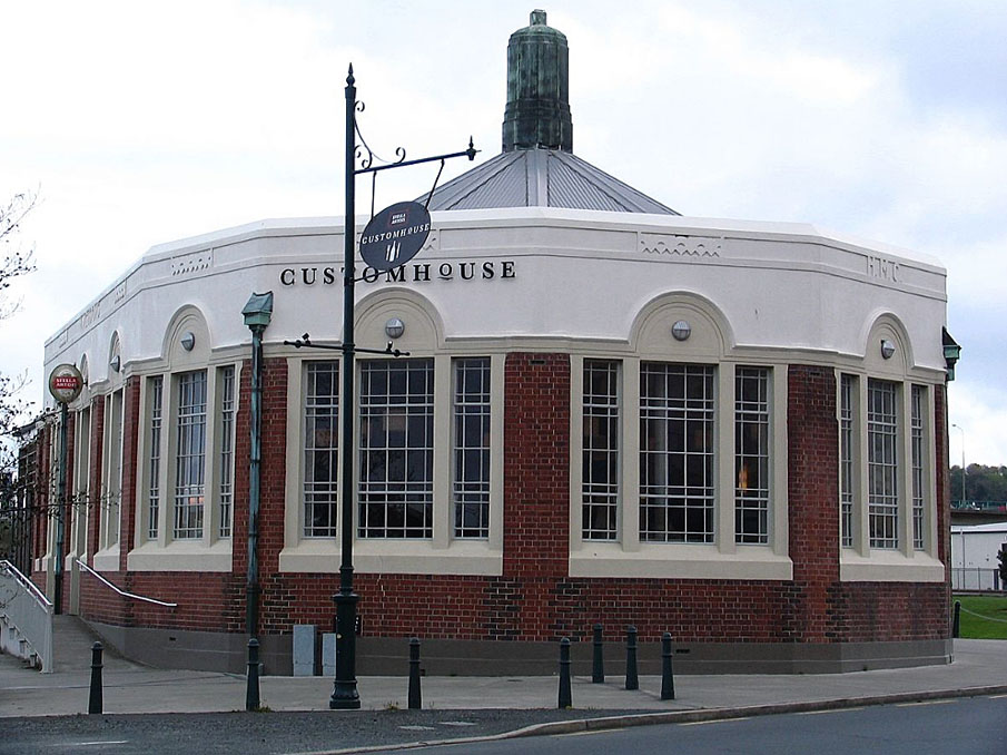
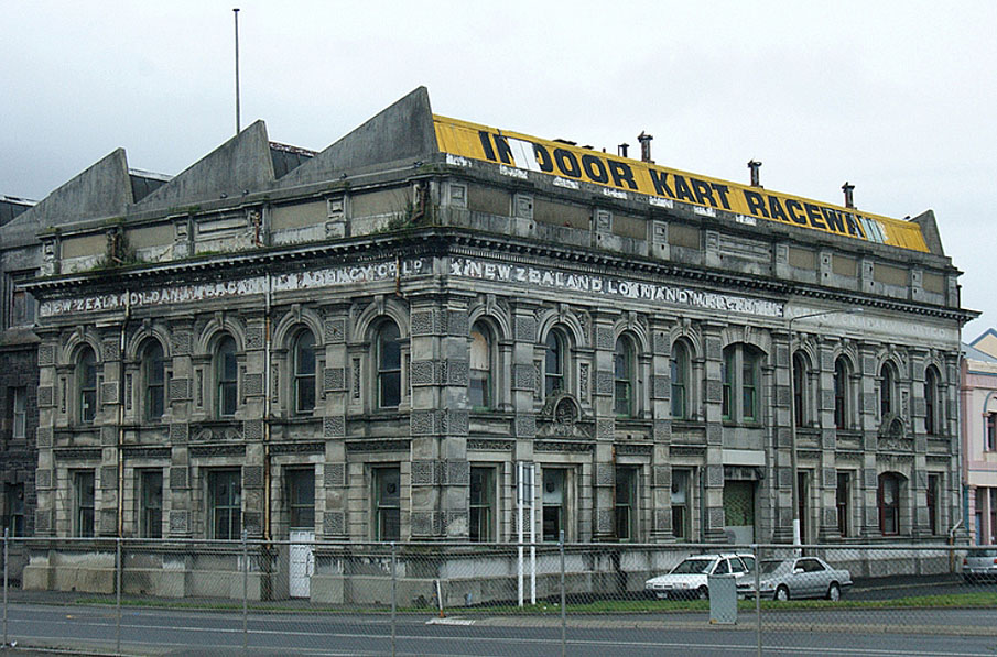
Sign up to hear more
Get the latest heritage news, features and events delivered
straight to your inbox.
