

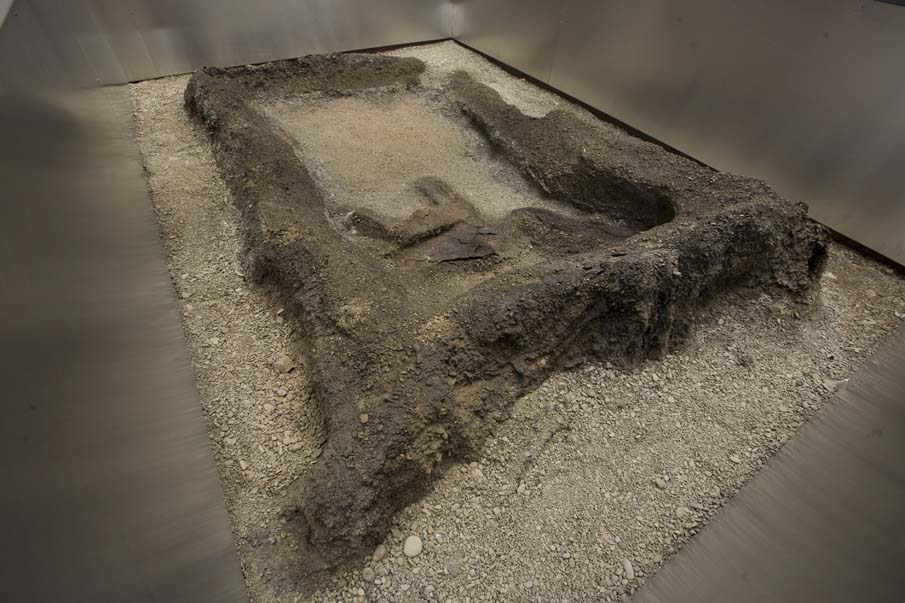
The remains of three ponga structures and associated archaeological features that constitute the extent of this registration are the only known remains of this once extensive settlement. These structures are closely associated with prominent Maori figures of the nineteenth century who are of national significance.
In 1908 a building was erected upon this site, and remained in place until November 2005. The archaeological remains of the three ponga structures were discovered during demolition for the redevelopment of the site. The structures have been preserved in situ and interpreted and can be visited by the public.
The site is of outstanding archaeological, architectural, cultural, historical, social, and traditional significance due to their association with early Wellington and North Island iwi, the archaeological rarity of the site, the educational value of the place as an example of early Maori residential architecture, and their strong associations with figures of cultural and social importance to Maori and Pakeha New Zealanders.
List Entry Information
Status
Listed
List Entry Status
Historic Place Category 1
Access
Able to Visit
List Number
7771
Date Entered
27th June 2008
Date of Effect
27th June 2008
City/District Council
Wellington City
Region
Wellington Region
Extent of List Entry
Extent includes the land comprised in Lot 1 DP 361972 (RT WN 252559) Wellington Land District. The extent of registration include Ponga Structures 1 and 2 and 3, their surrounding encasements, and associated archaeological features contained within the encasement.
Legal description
Lot 1 DP 361972 (RT 252559), Wellington Land District
Location Description
The site can be visited by the public. The site has been preserved and interpreted at street level and is located under a new residential aprtment block.
Why is this place significant?
Cultural Significance
The uncovering of this site provides a unique opportunity to address the cultural relationship between Maori and this particular place, and provide an insight to how Maori at Te Aro Pa lived. Social Significance or Value: The remains provide a tool to help in the understanding of early social history in Wellington, and are a case-study to guide understanding of Maori life at the time of initial European settlement in New Zealand. Spiritual Significance or Value: The uncovering of this site is of huge importance to Maori. As a visible, physical remnant of Te Aro Pa, the site is a spiritual, emotional and visibly tangible connection with tupuna Traditional Significance or Value: The remains are a case-study to guide understanding of Maori life at the time of initial European settlement in New Zealand.
Historic Significance
Historical Significance or Value Te Aro Pa represents a significant turning point in the development of Wellington as the capital city of New Zealand, and issues surrounding Maori land ownership in the early colonial history of New Zealand at both a local and national level. Te Aro Pa is closely associated with the important historical event of the purchase of Port Nicholson. This purchase had a major impact on the local Maori community, causing a decline in the Maori population at a regional level, and allowing for the colonial development of Wellington Harbour and its surrounds. This had implications on a national level as these developments paved the way for the eventual establishment of Wellington as the nation's capital. The acquisition of the land associated with Te Aro Pa was a crucial component of this urban growth. The three ponga structures at Te Aro Pa are the only physical remains of the once extensive site, and serve to highlight how a community was adversely affected by changes in its immediate surroundings. There has been continuity of association between this portion of Te Aro Pa and a number of people who are historically important Maori figures. This portion of Te Aro Pa has strong associations with Ngatata-i-te-rangi, who was one of the chiefs who signed the Treaty of Waitangi in Wellington in 1840. He permitted Ngati Haumia to settle at Te Aro Pa and in 1832 fixed the boundary between them and Ngati Ruanui. Lot 1 Application Plan 1749 is associated with Ngatata-i-te-rangi's son, Wiremu Tako Ngatata, who was a Member of the Legislative Council. Lot 1 Application Plan 711 is associated with Ahipane Marangai, and Raniera Ellison (or Erihana), and his son Thomas Rangiwahia Ellison. Tamati worked as an interpreter in the Native Land Court, and was a solicitor and, in 1892, was the first Maori to be admitted to the Bar. Tamati was also a representative ruby football player, and captained the first official New Zealand rugby team. Tamati Rangiwahia Ellison is regarded by many as the 'creator' of the All Blacks, thus possessing strong historical values to both the political and sporting history of New Zealand.
Physical Significance
Aesthetic & Archaeological Significance or Value: These remains at Te Aro Pa provide unique archaeological information that has the ability to act as an important reference site for researchers and students. The presence of archaeological remains of a 19th century Maori settlement in an urban context are extremely rare. It is possible that these remain are one of the only examples of this type of settlement in Wellington city, and the likelihood of further discoveries of this scale is uncertain. Similar structures have not been found elsewhere in New Zealand to date, and their in-situ preservation maintaining their physical context adds to the rarity value. The surviving in situ structures, in combination with the information from archaeological investigations, have the potential to provide important archaeological information in a number of areas. The site has important information potential on a regional level, as it provides information on the early transformation of the urban landscape in Wellington city. The site has important information potential for Maori in regards to building technology, settlement patterns and dwelling orientation and layout, and the way of life for Maori in a newly urbanised environment. Architectural Significance or Value: The three ponga structures provide a nationally unique physical example of early postcolonial Maori domestic architecture. These buildings reflect the closing phases of an architectural period in New Zealand, with the transfer from a traditional kainga plan and use of vernacular Maori structures and construction technology, to a European-based urban plan and domestic living arrangement. The structures were constructed using pre-European methods, using ponga as both a structural and cladding material for the building. The discovery of the remains of Te Aro Pa is of outstanding significance, as it was long assumed that all physical evidence of the pa was lost during the late 1800s - particularly during the 1855 earthquake. The fact that the fragile/brittle ponga have survived in their original context - despite the dry pebbly matrix in which they were built - and their location in an urban area adds greatly to their rarity and therefore significance. The information/educational potential provided by this site is of high national significance as these are possibly the only known remains of this type of ponga construction by Maori in the country. These remains provides information about the past specifically pertaining to Maori architectural history. The site and the plans for its preservation and public viewing allows for the ability to use the place to teach others about the past as a rich visual, educational, and community experience.
Why is this place Category 1 / Category 2?
Detail Of Assessed Criteria
(a) The extent to which the place reflects important or representative aspects of New Zealand history: The site provides important tangible evidence of early Maori life in the Whanganui a Tara / Wellington area, including that of Ngati Haumia (Taranaki) and Ngati Tupaia (Ngati Ruanui) hapu more than a century ago that has otherwise been lost from the cityscape. Te Aro Pa and this proposed registered historic place within it, traces the development of Wellington from its earliest known origins, to a Maori settlement, and later to the capital city of New Zealand. (b) The association of the place with events, persons, or ideas of importance in New Zealand history: The section of land that constitutes this registration is associated with significant figures in New Zealand's history. Ngatata-i-te-rangi is an important figure in Maori history and accounts of inter-tribal relationships and settlement patterns in the North Island. Wiremu Tako Ngatata is an important figure in the early political and social history of New Zealand, and Thomas Rangiwahia Ellison is an important figure in the history of the New Zealand legal system including the Native Land Court, and New Zealand sporting history and the story of the early years of the All Blacks. (c) The potential of the place to provide knowledge of New Zealand history: These remains at Te Aro Pa are nationally unique in archaeological terms and provide the opportunity to extend the current field of knowledge in regards to early architectural methods and techniques in New Zealand. The site provides new information to the fields of archaeology and architecture, and provides new insights into New Zealand social history. (d) The importance of the place to the tangata whenua: Te Aro Pa was a settlement place of Ngati Mutunga; Ngati Haumia (of Taranaki Iwi) and Ngati Tupaia (of Ngati Ruanui Iwi). The site also has strong associations with prominent tupuna and their descendants. Te Aro Pa, along with Pipitea Pa, were the two largest pa in the Town of Wellington, and during European colonisation in the 1840s, retention of Te Aro and Pipitea Pa were essential to Maori participating and benefiting from the development of Wellington. Te Aro Pa continues to possess strong cultural values to the descendants of Te Aro Pa and the wider Wellington area, the descendants of whom are represented in contemporary times by the Wellington Tenths Trust. (e) The community association with, or public esteem for the place: Following the discovery of these sites, the Wellington Tenths Trust has undertaken negotiations with landowners, developers, the Wellington City Council and other interested parties, and has made efforts to preserve the sites. There has been widespread interest generated amongst the public, as observed in local newspaper articles and letters to the editor. This interest points to the great significance of this site to the community in general. (f) The potential of the place for public education: The proposed preservation and maintenance of the ponga structures, the installation of glass flooring (portal windows) to enable viewing and interpretation would enable the public to get a first-hand experience of Te Aro Pa. This experience will provide the public with a better understanding of the early landscape in Wellington and how Maori adapted to live in one of the first urban environments in New Zealand. The remains of Te Aro Pa provide considerable potential for public interpretation and education. The site will be readily accessible to the public, and the location has contributed to public interest. The overall archaeological significance of the surviving structures is extremely high. They now represent the only tangible evidence of the site of Te Aro Pa in its original location. (h) The symbolic or commemorative value of the place: Te Aro Pa is currently commemorated in a park space a short distance from the proposed site of registration. The discovery of physical remains of the Pa adds substantial commemorative value to the area. The in-situ remains are a highly symbolic reminder of the wider Pa. (i) The importance of identifying historic places known to date from early periods of New Zealand settlement: The presence of archaeological remains of a 19th century Maori settlement in an urban context is extremely rare. Te Aro Pa is historic place with the potential to provide information towards common current research themes associated with early New Zealand history such as the archaeology of identity, early interactions between Maori and Pakeha, and the relationship between historical and archaeological information sources. The site is also a rare example of early Maori building technology, a field of research which there is currently very little recorded information about. (j) The importance of identifying rare types of historic places: The discovery of these ponga structures provides a unique record for the architectural history of New Zealand. In today's context, the survival of such an example of traditional building is extremely rare, particularly given the nature of the building materials and its location both historically, on the gravel foreshore, and in today's context, in urban Wellington. Summary of Significance or Values: This place was assessed against, and found it to qualify under the following criteria: a, b, c, d, e, f, h, i, j. Conclusion: It is considered that this place qualifies as a Category I historic place due to the outstanding archaeological, architectural, cultural, historical, social, and traditional significance, the archaeological rarity of the site, the educational value of the place as an example of early Maori residential architecture, and the strong association with figures of cultural and social importance to both Maori and all New Zealanders.
Construction Details
Type
Original Construction
Description
1830s
Start Year
1908
Type
Addition
Description
Construction of building over site
Start Year
2005
Type
Additional building added to site
Description
Demolition of building over site and erection of another building with provision for access to see the Toenga o Te Aro
Construction Materials
Ponga seems to have been employed for both the structure and cladding of the building.
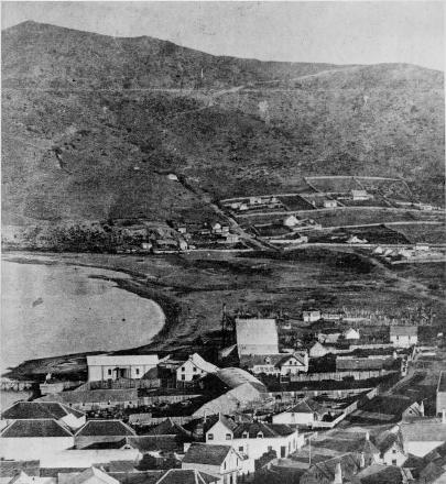
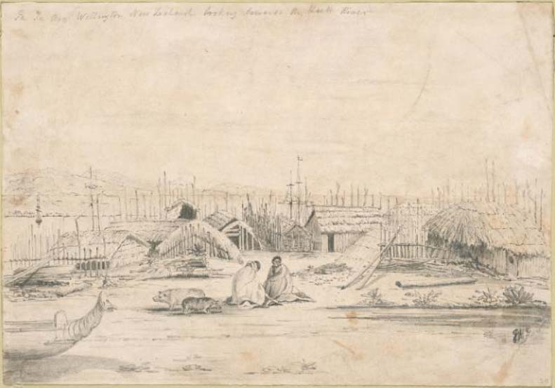
TRADITIONAL HISTORY: Te Aro Pa is part of a region that has connections to some of the earliest stories associated with New Zealand. Te Aro Pa is located within the area known as Te Upoko o Te Ika a Maui (the head of the fish of Maui). Te Ika a Maui is 'the fish of Maui', and in Maori mythology, Maui (the famous Polynesian ancestor) fished up the North Island, raising it to the surface for later inhabitation . The early Polynesian explorer Kupe was the first known ancestor of Maori to visit the Wellington area and named various places within close proximity to Te Aro Pa such as Matiu (Somes Island) and Makaro (Ward Island). The harbour area on which Te Aro Pa is located was named during the following period of Maori exploration and occupation by Whatonga, who named the harbour in honour of his son Tara - hence the original name for Wellington Harbour - Te Whanganui a Tara ('the great harbour of Tara'). EARLY HISTORY: The earliest recorded inhabitants of the Wellington Harbour region were descended from the Kurahaupo waka, such as Ngai Tara, Rangitane, Muaupoko and Ngati Apa . The Port Nicholson Block was occupied by Ngati Ira, Rakaiwhakairi, and Ngati Kahukuraawhitia, and it was these iwi that had early tangata whenua rights in the area . During the period 1819 to 1836 Te Whanganui a Tara was invaded at least six times , and following the battle Waiorua in 1824 a significant migration - known as the Nihoputa, or 'boar's tusk' - left Taranaki for Te Upoko o te Ika. This group was made up members of Ngati Mutunga, Ngati Tama, and Te Atiawa who were ‘fleeing Waikato vengeance in Taranaki' . The migratory group included the chiefs Pomare of Ngati Mutunga, and Ngatata i te Rangi of the Ngati Te Whiti and Ngati Tawhirikura hapu of Te Atiawa. In the Wellington Tenths Trust Cultural Impact Report of January 2004, the early settlement history of Wellington Harbour is appropriately described as ‘...and extraordinarily complex situation where the term ‘tangata whenua' needs to be couched in historical context.' After a period of co-existence between the recently arrived Ngati Mutunga and previously settled Ngati Ira at Te Whanaganui a Tara, Ngati Mutunga launched an attack on Ngati Ira and expelled them from the area in the late 1820s . ESTABLISHMENT AND INHABITATION OF TE ARO PA: Te Aro Pa was established by Ngati Mutunga in 1824; however the iwi left the region to relocate to the Chatham Islands in November 1835, at which point Ngati Mutunga rangatira left their lands from Waitangi Stream to Ngauranga in the possession of Taranaki iwi. The kainga at Te Aro was subsequently split into two parts, and occupied by the Ngati Tupaia hapu of Ngati Ruanui iwi at the eastern end, and Ngati Haumia hapu from Taranaki iwi at the western end . At the time of European colonisation, Te Aro Pa is described as having approximately 35 Ngati Ruanui living at the eastern end, and about 93 Taranaki Maori living on the western side . The Waitangi Tribunal report in 2003 made the following assertions in regards to tangata whenua status in the area occupied by Te Aro Pa: At 1840, Maori groups with ahi ka rights within the Port Nicholson block (as extended in 1844 to the south-west coast) were Te Atiawa at Te Whanganui a Tara and parts of the south-west coast; Taranaki and Ngati Ruanui at Te Aro; Ngati Tama at Kaiwharawhara and environs and parts of the south-west coast; and Ngati Toa at Heretaunga and parts of the south-west coast. These groups also had take raupatu over the remainder of Port Nicholson block. Further associating Te Aro Pa with Taranaki iwi, Elsdon Best attributes the naming of Te Aro Pa to the explanation that ‘Te Aro' means the face or the front, in reference to the site facing Taranaki Maunga where the inhabitants originated . FURTHER LAND DIVISION AND EUROPEAN COLONISATION: Te Aro Pa along with Pipitea Pa, were the two largest pa in the town of Wellington. During Pakeha colonisation in the 1840s, retention of Te Aro and Pipitea Pa were essential to Maori participating and benefiting from the development of Wellington. However Te Aro Pa was also highly valued for providing access through Taranaki Street to lands being reclaimed on the waterfront and the proposed Customhouse site. THE NEW ZEALAND COMPANY DEED OF PURCHASE: In May 1839 the New Zealand Company under Colonel William Wakefield printed a prospectus for New Zealand advertising 990 lots of Port Nicholson land for sale. All 990 lots were sold by July 1839, before the company's representatives had even arrived in New Zealand to purchase the land from the existing Maori inhabitants . In September 1839 the New Zealand Company signed an agreement with some local Maori to allocate land for British colonisation. The signatories were described by the New Zealand Company as ‘the sole and only proprietors, or owners' of Port Nicholson although it is stated in the Waitangi Tribunal report on the district that no signatory from Te Aro Pa contributed to the signing of the deed . Maori living at Te Aro Pa refused to sell their pa or any of their land around Wellington to the New Zealand Company. During the McCleverty Commission of 1847, J. Pyatt noted that: ‘The first indications to the New Zealand Company officials that all was not well came in February 1840 when Mein-Smith, the Company's Surveyor General and his assistants, began to survey and mark out the plan for the town of Wellington. The survey pegs and lines, passing straight through the Pa, cultivations, tapu burial grounds and occupied lands alike, were promptly pulled out by Maori of Te Aro, Pipitea, Kumutoto, and Tiakiwai. They strongly denied that the town site had been sold.' The area of lower Taranaki Street was set out in the 1840 survey of Wellington City and 39-43 Taranaki Street was located within Reserve 9, a town acre between TA 215 and 216. This reserve encompassed part of Te Aro Pa, and sketches and anecdotal evidence of the time suggests the Pa extended beyond this immediate vicinity. A sketch of Te Aro Pa from approximately this period by Edmund Norman shows a number of raupo buildings of varying sizes, a canoe, and a substantial pallisaded fence (see Appendix 4.3.2). THE TREATY OF WAITANGI AND THE SPAIN COMMISSION OF 1842: The Treaty of Waitangi was signed at Te Whanganui-a-Tara on the 29th of April 1840 after ten days of deliberation by the 34 Maori signatories of the area. With the signing of the Treaty came an investigation into the New Zealand Company's dealings. On 15 May 1842, a land claims commission - headed by English lawyer William Spain - began to hear the New Zealand Company's claim to Wellington. Spain's preliminary report of 12 September 1843 found that ‘I am further of opinion, that the natives did not consent to alienate their pahs, cultivations and burying-grounds . Subsequently, the area of Te Aro was officially brought into the 1839 New Zealand Company Purchase in 1844, and at that time it was stated that the pa, cultivations, and urupa were to be excluded from the land that was released by Maori. SPAIN ATTEMPTED TO DEFINE THE EXTENTS OF THE PA IN HIS FINAL REPORT OF 1845: ‘The limits of the pahs to be the ground fenced in around their native houses, including the ground in cultivation or occupation around the adjoining houses without the fence; and cultivations as those tracts of country which are now used by the natives for vegetable productions, or which have been so used by the aboriginal natives of New Zealand since the establishment of the colony.' THE McCLEVERTY TRANACTIONS OF 1847: The inclusion of ‘cultivations' in the exceptions of the New Zealand Company Purchase led to disputes between Maori and settlers. Of the 639 acres under cultivation by Maori, 528 were on sections sold to Europeans . In 1845 Lieutenant Colonel William Anson McCleverty was appointed to obtain deeds from the tribes concerned, exchanging their settlements and cultivations for land elsewhere. This transfer of cultivated lands had disastrous affects on the ability of Te Aro Maori to cultivate food for subsistence, with Wesleyan missionary Rev. James Watkins reporting that some had to go ‘fifteen miles to cultivate potatoes on land rented from white men'. The New Zealand Company had not recognized Te Aro Pa as a native reserve (only three of the nine pa sites on Wellington harbour had been allocated as reserves), however the rights of Te Aro Pa inhabitants were recognised by McCleverty, and on 7 October 1847, Maori at Te Aro Pa were awarded a further 50 acres. By 1850 Te Aro Pa had 186 inhabitants of Taranaki and Ngati Ruanui descent, but within the same decade the Wesleyan missionaries who lived on land gifted by Te Aro Maori noted that only ‘a small remnant of a once considerable tribe occupy a few miserable huts not far from the Mission House'. THE 1855 EARTHQUAKE: The site and surroundings of Te Aro Pa were greatly affected by the magnitude 8.1 earthquake of 1855 which uplifted the entire Wellington peninsula and tilted it to the west. The uplift created a new fringe of beach and rock platforms along the Wellington coast, and lifted the entire shoreline of Wellington harbour. The previously low-lying marsh-areas such as those surrounding Waitangi Stream provided a substantial source of food (predominantly shellfish and eels), and also an area of cultivation of flax, which provided trading opportunities with European settlers. Within several decades of this earthquake however, the land surrounding Waitangi Stream was completely reclaimed, the stream was culverted, and the former traditional use patterns lost.. THE NATIVE LANDS ACT OF 1865 AND DIVISION OF TE ARO PA: In 1861 there were only 9 inhabitants at Te Aro Pa. This was largely due to the number of former residents that went to Taranaki to assist in the war efforts of the region. By 1874 the numbers were up to 59, although this was still substantially lower than previously recorded figures. Between 1866 and 1868 under the Native Lands Act of 1865, Te Aro Pa was surveyed into 28 allotments that were Crown-granted to individuals and small groups. On the 1866 map, Section 26 (which is included in the proposed extent of this registration proposal) is annotated with the name Ngahirau. According to Hori Nga Paka in a Native Land Court hearing in Wellington on 10 February 1870, Ngahirau built a house with Ngati-i-te-rangi . A number of buildings are indicated on this plan including a Maori Chapel in the southwest corner of Courtenay Place, and a building in the northwest corner of Section 24, of which Maori landowners are noted. Any sale of these lots had to be approved by the Native Commissioner of Native Reserves on behalf of the Government. The Waitangi Tribunal findings on the situation at Te Aro Pa during this period include the following: ‘The perception that both Te Aro Pa and the wider Te Aro district which surrounded it were a blight on the city may have contributed to the pa's demise. From the earliest days of the Port Nicholson settlement, settlers objected strongly to the communal lifestyle of the pa on the grounds of morality, health, safety, and aesthetics. In addition, by the 1860s the Te Aro Flat area where Te Aro Pa was located had become a notoriously overcrowded slum, although it was not until the 1930s that a concerted attempt was made to remedy the overcrowding and other slum conditions. While there is no evidence that Te Aro Pa was ‘removed' as part of any slum clearance, the belief that the pa constituted a slum within a slum no doubt made the authorities more willing to consent to the alienation of this land. There is very clear evidence that Commissioner Heaphy, for one, wished to see both Te Aro Pa and Pipitea Pa removed from Wellington city. Heaphy took a very favourable view of proposals to alienate McCleverty reserve land in Te Aro and Pipitea Pa, seeing them as an exception to the usual rule that reserve land required for Maori should be preserved for Maori. Describing Te Aro Pa as ‘a nest of immorality', Heaphy argued that for ‘moral & sanitary reasons' it was desirable for the sake of Maori and Pakeha alike that Maori should leave the town and that the pa land should pass into Pakeha hands.' The Ward Plan of 1891 shows several buildings on Section 24 (also included in the proposed extent of this registration proposal). There are three houses and another building located behind the two-bedroom house that may have been a workshop. Section 24 has been further subdivided and what is now 39-43 Taranaki St is Lot 1 at the north end of the land parcel. Two buildings are shown on Lot 1, with another building straddling the boundary between Lots 1 and 2. In the 1880s, reclamation took place at Lambton Harbour, and later at Te Aro. By 1886, close to nine hectares had been added to the Te Aro foreshore from fill railed in from Oriental Bay. ASSOCIATION OF PROPOSED EXTNET OF REGISTRATION WITH HISTORICAL FIGURES: This specific portion of Te Aro Pa proposed for registration has strong associations with individuals and descendant families from the pa. The sections involved in the current development are sections 24 and 26, being part of Wellington Town Sections 216 and part of Te Aro Pa Reserve. Section 26 - as shown in the 1866 map - was allocated to Ngahirau's son Wi Tako Ngatata and Retimana Pukahu in 1877, but a substantial portion of this was taken by public proclamation in late 1870s to provide access to the reclamation and what was to become Taranaki Wharf. Nearly all of Section 26 is now part of Taranaki Street. Most of the development currently being undertaken by Washington Ltd is on part of Section 24 which was originally allocated to Ahipane Marangai and passed down to Raniera Erihana and his son Thomas (Tame) Rangiwahia Erihana. Te Aro Pa is associated at its earliest stages with Ngatata-i-te-rangi, one of the chiefs who signed the Treaty of Waitangi in Wellington. It was Ngatata-i-te-rangi who permitted Ngati Haumia to settle at Te Aro and in 1832 fixed the boundary between them and Ngati Ruanui. The structures on Section 26 are associated with Ngatata-i-te-rangi's son, Wiremu Tako Ngatata, who assumed the leadership role from his father in the 1860s. Wiremu Tako Ngatata is renowned for taking issues regarding Crown acquisition of land, (including Section 26) to the Native Land Court. Ngatata later went on to become a Member of the Legislative Council in 1872. When Wi Tako Ngatata died in 1887, and the Legislative Council adjourned out of respect, and Council member Dr. Grace is noted as saying: ‘...Sir, it is impossible for me to consider the disappearance of a man like Wi Tako Ngatata from our midst without giving expression to the boundless feeling of admiration I entertain for men of his type. I say, Sir, that if we have not sufficient greatness of soul to set the proper value on the services rendered to this colony by men like Wi Tako Ngatata we have not been worthy of the services which they have been rendered,-we are not worthy of the security which we enjoy, and owe so largely to their services. There was a time when Wi Tako held the balance of power between the Maori King Potatau and the English Queen; a time during the war when he had two thousand armed men under his control, and had he thrown his tomahawk to the right or left, and lent his influence to the Maori King, I do not know what would have become of this settlement. I say we have lost in him one of the greatest Natives this country, rich in great men, has ever borne. What sacrifices did the honourable gentleman make for the benefit of the Europeans! He imperilled by his loyalty to us the whole of his influence with the Native race. Every one must know how the spirit of nationality with a volcanic throb moved the Maori people at that time. Who is there that can fail to see the greatness of soul which actuated Wiremu Tamihana when he conceived the idea of a Maori nationality, and who, realising this, can fail to admit the nicety of the balance of power between the races that existed at that time? It was then Wi Tako, failing to be carried away by the passing impulse of the moment, holding the scales between the two races, gave us the full advantage of his sympathy and, ultimately of his support. I have heard the late Dr Featherston say of him, ‘Wi Tako is the cleverest man, black or white, in the country.' That was his estimate of the man's skill, and his appreciation of Wi Tako's power of controlling the wild races he held in the leash...' The area within the boundaries of Section 24 is associated with Ahipane Marangai, Raniera Ellison (or Erihana), and his son Thomas (Tamati) Rangiwahia Ellison. Thomas Rangiwahia Ellison (Ngai Tahu, Te Ati Awa) is known for his success as both a rugby player and a lawyer. In 1893 Ellison captained the first official New Zealand team. At the first annual general meeting of the New Zealand Rugby Football Union Ellison put forward the proposal that the uniform for the New Zealand Rugby team be a black jersey with silver fern monogram, black cap and stockings and white knickerbockers. This became the familiar All Black uniform that remains an internationally recognised icon of New Zealand. In 1902 Ellison authored the early rugby coaching manual The Art of Rugby Football. Ellison also worked as an interpreter in the Native Land Court from 1886, and from 1891 worked as a solicitor. In 1902 he was admitted to the Bar, one of the first Maori to achieve this. Ellison died in 1904 however, while only in his thirties, and was returned to his birthplace of Otakou to be buried. Subsequently, Section 24 was sold by Raniera Erihana and The Public Trust to Thomas J Young in 1906. In addition to these historical figures of note, in 1842 Wi Tako Ngatata and Ropiha Moturoa named between eight and twenty-three rangatira living at Te Aro Kainga, including Mohi Ngaponga, Hemi Parae, Toko, Puhi, and Pukahu. It should be noted that the wider extents of Te Aro Pa are associated with many more key historic figures, and this proposal has only discussed figures directly associated with the portion of land under consideration for registration.
TRADITIONAL HISTORY: Te Aro Pa is part of a region that has connections to some of the earliest stories associated with New Zealand. Te Aro Pa is located within the area known as Te Upoko o Te Ika a Maui (the head of the fish of Maui). Te Ika a Maui is 'the fish of Maui', and in Maori mythology, Maui (the famous Polynesian ancestor) fished up the North Island, raising it to the surface for later inhabitation . The early Polynesian explorer Kupe was the first known ancestor of Maori to visit the Wellington area and named various places within close proximity to Te Aro Pa such as Matiu (Somes Island) and Makaro (Ward Island). The harbour area on which Te Aro Pa is located was named during the following period of Maori exploration and occupation by Whatonga, who named the harbour in honour of his son Tara - hence the original name for Wellington Harbour - Te Whanganui a Tara ('the great harbour of Tara'). EARLY HISTORY: The earliest recorded inhabitants of the Wellington Harbour region were descended from the Kurahaupo waka, such as Ngai Tara, Rangitane, Muaupoko and Ngati Apa . The Port Nicholson Block was occupied by Ngati Ira, Rakaiwhakairi, and Ngati Kahukuraawhitia, and it was these iwi that had early tangata whenua rights in the area . During the period 1819 to 1836 Te Whanganui a Tara was invaded at least six times , and following the battle Waiorua in 1824 a significant migration - known as the Nihoputa, or 'boar's tusk' - left Taranaki for Te Upoko o te Ika. This group was made up members of Ngati Mutunga, Ngati Tama, and Te Atiawa who were ‘fleeing Waikato vengeance in Taranaki' . The migratory group included the chiefs Pomare of Ngati Mutunga, and Ngatata i te Rangi of the Ngati Te Whiti and Ngati Tawhirikura hapu of Te Atiawa. In the Wellington Tenths Trust Cultural Impact Report of January 2004, the early settlement history of Wellington Harbour is appropriately described as ‘...and extraordinarily complex situation where the term ‘tangata whenua' needs to be couched in historical context.' After a period of co-existence between the recently arrived Ngati Mutunga and previously settled Ngati Ira at Te Whanaganui a Tara, Ngati Mutunga launched an attack on Ngati Ira and expelled them from the area in the late 1820s . ESTABLISHMENT AND INHABITATION OF TE ARO PA: Te Aro Pa was established by Ngati Mutunga in 1824; however the iwi left the region to relocate to the Chatham Islands in November 1835, at which point Ngati Mutunga rangatira left their lands from Waitangi Stream to Ngauranga in the possession of Taranaki iwi. The kainga at Te Aro was subsequently split into two parts, and occupied by the Ngati Tupaia hapu of Ngati Ruanui iwi at the eastern end, and Ngati Haumia hapu from Taranaki iwi at the western end . At the time of European colonisation, Te Aro Pa is described as having approximately 35 Ngati Ruanui living at the eastern end, and about 93 Taranaki Maori living on the western side . The Waitangi Tribunal report in 2003 made the following assertions in regards to tangata whenua status in the area occupied by Te Aro Pa: At 1840, Maori groups with ahi ka rights within the Port Nicholson block (as extended in 1844 to the south-west coast) were Te Atiawa at Te Whanganui a Tara and parts of the south-west coast; Taranaki and Ngati Ruanui at Te Aro; Ngati Tama at Kaiwharawhara and environs and parts of the south-west coast; and Ngati Toa at Heretaunga and parts of the south-west coast. These groups also had take raupatu over the remainder of Port Nicholson block. Further associating Te Aro Pa with Taranaki iwi, Elsdon Best attributes the naming of Te Aro Pa to the explanation that ‘Te Aro' means the face or the front, in reference to the site facing Taranaki Maunga where the inhabitants originated . FURTHER LAND DIVISION AND EUROPEAN COLONISATION: Te Aro Pa along with Pipitea Pa, were the two largest pa in the town of Wellington. During Pakeha colonisation in the 1840s, retention of Te Aro and Pipitea Pa were essential to Maori participating and benefiting from the development of Wellington. However Te Aro Pa was also highly valued for providing access through Taranaki Street to lands being reclaimed on the waterfront and the proposed Customhouse site. THE NEW ZEALAND COMPANY DEED OF PURCHASE: In May 1839 the New Zealand Company under Colonel William Wakefield printed a prospectus for New Zealand advertising 990 lots of Port Nicholson land for sale. All 990 lots were sold by July 1839, before the company's representatives had even arrived in New Zealand to purchase the land from the existing Maori inhabitants . In September 1839 the New Zealand Company signed an agreement with some local Maori to allocate land for British colonisation. The signatories were described by the New Zealand Company as ‘the sole and only proprietors, or owners' of Port Nicholson although it is stated in the Waitangi Tribunal report on the district that no signatory from Te Aro Pa contributed to the signing of the deed . Maori living at Te Aro Pa refused to sell their pa or any of their land around Wellington to the New Zealand Company. During the McCleverty Commission of 1847, J. Pyatt noted that: ‘The first indications to the New Zealand Company officials that all was not well came in February 1840 when Mein-Smith, the Company's Surveyor General and his assistants, began to survey and mark out the plan for the town of Wellington. The survey pegs and lines, passing straight through the Pa, cultivations, tapu burial grounds and occupied lands alike, were promptly pulled out by Maori of Te Aro, Pipitea, Kumutoto, and Tiakiwai. They strongly denied that the town site had been sold.' The area of lower Taranaki Street was set out in the 1840 survey of Wellington City and 39-43 Taranaki Street was located within Reserve 9, a town acre between TA 215 and 216. This reserve encompassed part of Te Aro Pa, and sketches and anecdotal evidence of the time suggests the Pa extended beyond this immediate vicinity. A sketch of Te Aro Pa from approximately this period by Edmund Norman shows a number of raupo buildings of varying sizes, a canoe, and a substantial pallisaded fence (see Appendix 4.3.2). THE TREATY OF WAITANGI AND THE SPAIN COMMISSION OF 1842: The Treaty of Waitangi was signed at Te Whanganui-a-Tara on the 29th of April 1840 after ten days of deliberation by the 34 Maori signatories of the area. With the signing of the Treaty came an investigation into the New Zealand Company's dealings. On 15 May 1842, a land claims commission - headed by English lawyer William Spain - began to hear the New Zealand Company's claim to Wellington. Spain's preliminary report of 12 September 1843 found that ‘I am further of opinion, that the natives did not consent to alienate their pahs, cultivations and burying-grounds . Subsequently, the area of Te Aro was officially brought into the 1839 New Zealand Company Purchase in 1844, and at that time it was stated that the pa, cultivations, and urupa were to be excluded from the land that was released by Maori. SPAIN ATTEMPTED TO DEFINE THE EXTENTS OF THE PA IN HIS FINAL REPORT OF 1845: ‘The limits of the pahs to be the ground fenced in around their native houses, including the ground in cultivation or occupation around the adjoining houses without the fence; and cultivations as those tracts of country which are now used by the natives for vegetable productions, or which have been so used by the aboriginal natives of New Zealand since the establishment of the colony.' THE McCLEVERTY TRANACTIONS OF 1847: The inclusion of ‘cultivations' in the exceptions of the New Zealand Company Purchase led to disputes between Maori and settlers. Of the 639 acres under cultivation by Maori, 528 were on sections sold to Europeans . In 1845 Lieutenant Colonel William Anson McCleverty was appointed to obtain deeds from the tribes concerned, exchanging their settlements and cultivations for land elsewhere. This transfer of cultivated lands had disastrous affects on the ability of Te Aro Maori to cultivate food for subsistence, with Wesleyan missionary Rev. James Watkins reporting that some had to go ‘fifteen miles to cultivate potatoes on land rented from white men'. The New Zealand Company had not recognized Te Aro Pa as a native reserve (only three of the nine pa sites on Wellington harbour had been allocated as reserves), however the rights of Te Aro Pa inhabitants were recognised by McCleverty, and on 7 October 1847, Maori at Te Aro Pa were awarded a further 50 acres. By 1850 Te Aro Pa had 186 inhabitants of Taranaki and Ngati Ruanui descent, but within the same decade the Wesleyan missionaries who lived on land gifted by Te Aro Maori noted that only ‘a small remnant of a once considerable tribe occupy a few miserable huts not far from the Mission House'. THE 1855 EARTHQUAKE: The site and surroundings of Te Aro Pa were greatly affected by the magnitude 8.1 earthquake of 1855 which uplifted the entire Wellington peninsula and tilted it to the west. The uplift created a new fringe of beach and rock platforms along the Wellington coast, and lifted the entire shoreline of Wellington harbour. The previously low-lying marsh-areas such as those surrounding Waitangi Stream provided a substantial source of food (predominantly shellfish and eels), and also an area of cultivation of flax, which provided trading opportunities with European settlers. Within several decades of this earthquake however, the land surrounding Waitangi Stream was completely reclaimed, the stream was culverted, and the former traditional use patterns lost.. THE NATIVE LANDS ACT OF 1865 AND DIVISION OF TE ARO PA: In 1861 there were only 9 inhabitants at Te Aro Pa. This was largely due to the number of former residents that went to Taranaki to assist in the war efforts of the region. By 1874 the numbers were up to 59, although this was still substantially lower than previously recorded figures. Between 1866 and 1868 under the Native Lands Act of 1865, Te Aro Pa was surveyed into 28 allotments that were Crown-granted to individuals and small groups. On the 1866 map, Section 26 (which is included in the proposed extent of this registration proposal) is annotated with the name Ngahirau. According to Hori Nga Paka in a Native Land Court hearing in Wellington on 10 February 1870, Ngahirau built a house with Ngati-i-te-rangi . A number of buildings are indicated on this plan including a Maori Chapel in the southwest corner of Courtenay Place, and a building in the northwest corner of Section 24, of which Maori landowners are noted. Any sale of these lots had to be approved by the Native Commissioner of Native Reserves on behalf of the Government. The Waitangi Tribunal findings on the situation at Te Aro Pa during this period include the following: ‘The perception that both Te Aro Pa and the wider Te Aro district which surrounded it were a blight on the city may have contributed to the pa's demise. From the earliest days of the Port Nicholson settlement, settlers objected strongly to the communal lifestyle of the pa on the grounds of morality, health, safety, and aesthetics. In addition, by the 1860s the Te Aro Flat area where Te Aro Pa was located had become a notoriously overcrowded slum, although it was not until the 1930s that a concerted attempt was made to remedy the overcrowding and other slum conditions. While there is no evidence that Te Aro Pa was ‘removed' as part of any slum clearance, the belief that the pa constituted a slum within a slum no doubt made the authorities more willing to consent to the alienation of this land. There is very clear evidence that Commissioner Heaphy, for one, wished to see both Te Aro Pa and Pipitea Pa removed from Wellington city. Heaphy took a very favourable view of proposals to alienate McCleverty reserve land in Te Aro and Pipitea Pa, seeing them as an exception to the usual rule that reserve land required for Maori should be preserved for Maori. Describing Te Aro Pa as ‘a nest of immorality', Heaphy argued that for ‘moral & sanitary reasons' it was desirable for the sake of Maori and Pakeha alike that Maori should leave the town and that the pa land should pass into Pakeha hands.' The Ward Plan of 1891 shows several buildings on Section 24 (also included in the proposed extent of this registration proposal). There are three houses and another building located behind the two-bedroom house that may have been a workshop. Section 24 has been further subdivided and what is now 39-43 Taranaki St is Lot 1 at the north end of the land parcel. Two buildings are shown on Lot 1, with another building straddling the boundary between Lots 1 and 2. In the 1880s, reclamation took place at Lambton Harbour, and later at Te Aro. By 1886, close to nine hectares had been added to the Te Aro foreshore from fill railed in from Oriental Bay. ASSOCIATION OF PROPOSED EXTNET OF REGISTRATION WITH HISTORICAL FIGURES: This specific portion of Te Aro Pa proposed for registration has strong associations with individuals and descendant families from the pa. The sections involved in the current development are sections 24 and 26, being part of Wellington Town Sections 216 and part of Te Aro Pa Reserve. Section 26 - as shown in the 1866 map - was allocated to Ngahirau's son Wi Tako Ngatata and Retimana Pukahu in 1877, but a substantial portion of this was taken by public proclamation in late 1870s to provide access to the reclamation and what was to become Taranaki Wharf. Nearly all of Section 26 is now part of Taranaki Street. Most of the development currently being undertaken by Washington Ltd is on part of Section 24 which was originally allocated to Ahipane Marangai and passed down to Raniera Erihana and his son Thomas (Tame) Rangiwahia Erihana. Te Aro Pa is associated at its earliest stages with Ngatata-i-te-rangi, one of the chiefs who signed the Treaty of Waitangi in Wellington. It was Ngatata-i-te-rangi who permitted Ngati Haumia to settle at Te Aro and in 1832 fixed the boundary between them and Ngati Ruanui. The structures on Section 26 are associated with Ngatata-i-te-rangi's son, Wiremu Tako Ngatata, who assumed the leadership role from his father in the 1860s. Wiremu Tako Ngatata is renowned for taking issues regarding Crown acquisition of land, (including Section 26) to the Native Land Court. Ngatata later went on to become a Member of the Legislative Council in 1872. When Wi Tako Ngatata died in 1887, and the Legislative Council adjourned out of respect, and Council member Dr. Grace is noted as saying: ‘...Sir, it is impossible for me to consider the disappearance of a man like Wi Tako Ngatata from our midst without giving expression to the boundless feeling of admiration I entertain for men of his type. I say, Sir, that if we have not sufficient greatness of soul to set the proper value on the services rendered to this colony by men like Wi Tako Ngatata we have not been worthy of the services which they have been rendered,-we are not worthy of the security which we enjoy, and owe so largely to their services. There was a time when Wi Tako held the balance of power between the Maori King Potatau and the English Queen; a time during the war when he had two thousand armed men under his control, and had he thrown his tomahawk to the right or left, and lent his influence to the Maori King, I do not know what would have become of this settlement. I say we have lost in him one of the greatest Natives this country, rich in great men, has ever borne. What sacrifices did the honourable gentleman make for the benefit of the Europeans! He imperilled by his loyalty to us the whole of his influence with the Native race. Every one must know how the spirit of nationality with a volcanic throb moved the Maori people at that time. Who is there that can fail to see the greatness of soul which actuated Wiremu Tamihana when he conceived the idea of a Maori nationality, and who, realising this, can fail to admit the nicety of the balance of power between the races that existed at that time? It was then Wi Tako, failing to be carried away by the passing impulse of the moment, holding the scales between the two races, gave us the full advantage of his sympathy and, ultimately of his support. I have heard the late Dr Featherston say of him, ‘Wi Tako is the cleverest man, black or white, in the country.' That was his estimate of the man's skill, and his appreciation of Wi Tako's power of controlling the wild races he held in the leash...' The area within the boundaries of Section 24 is associated with Ahipane Marangai, Raniera Ellison (or Erihana), and his son Thomas (Tamati) Rangiwahia Ellison. Thomas Rangiwahia Ellison (Ngai Tahu, Te Ati Awa) is known for his success as both a rugby player and a lawyer. In 1893 Ellison captained the first official New Zealand team. At the first annual general meeting of the New Zealand Rugby Football Union Ellison put forward the proposal that the uniform for the New Zealand Rugby team be a black jersey with silver fern monogram, black cap and stockings and white knickerbockers. This became the familiar All Black uniform that remains an internationally recognised icon of New Zealand. In 1902 Ellison authored the early rugby coaching manual The Art of Rugby Football. Ellison also worked as an interpreter in the Native Land Court from 1886, and from 1891 worked as a solicitor. In 1902 he was admitted to the Bar, one of the first Maori to achieve this. Ellison died in 1904 however, while only in his thirties, and was returned to his birthplace of Otakou to be buried. Subsequently, Section 24 was sold by Raniera Erihana and The Public Trust to Thomas J Young in 1906. In addition to these historical figures of note, in 1842 Wi Tako Ngatata and Ropiha Moturoa named between eight and twenty-three rangatira living at Te Aro Kainga, including Mohi Ngaponga, Hemi Parae, Toko, Puhi, and Pukahu. It should be noted that the wider extents of Te Aro Pa are associated with many more key historic figures, and this proposal has only discussed figures directly associated with the portion of land under consideration for registration.
Although a specific designer/architect is not able to be individually identified for the three structures, these ponga structures are part of the vernacular (or traditional architectural) heritage of New Zealand. The structures are built using traditional methods, where the designs are refined over generations of construction and reconstruction . Early Descriptions of the Wider Pa Site: Colonial commentators provide us with descriptions of Te Aro Pa from as early as 1845. George French Angas famously visited the pa in 1845, where he undertook a series of watercolour portraits before continuing his travels through the Wellington region. He described the pa as follows; 'Te Aro Pa is larger than Pipitea Pa. The houses or huts are mostly of reeds, sheeted with bark.' General Archaeological Context of Site: The Site of Te Aro Pa is recorded in the NZAA Site Recording Scheme as part of Te Aro Kainga NZAA R27/154. An archaeological excavation was undertaken in part of the historical site of Te Aro Kainga in 1987 where no evidence of the pa was found. The 2005 archaeological discoveries however showed a variety of archaeological features at the site. Within the vicinity of the remaining ponga structures the piles of the 1908 building are still present, and drains that predate the 1908 building were also observed. A layer of grey sediment was found that potentially covered the whole site, and revealed a small midden containing shell and fire-cracked rock. Elements that are directly associated with the ponga structures are outlined as follows : The remains of three low rectangular ponga structures built immediately on top of the beach gravel which forms the base of the site. Structure 1 contained a clay pipe bowl. Structure 3 has only been partially excavated and has revealed two intact bottles below either a wooden floor or collapsed walls. In the exterior wall at the southwest corner an iron bucket had been dug into the wall from a higher layer that contained glass and intact bottles and is the remains of a later 19th century rubbish pit. A total of four rubbish pits were recorded between Structure 3 and Taranaki St. One has metal strapping (which is possibly the remains of two barrels) and sits on a brick platform - the function of which is unknown. There was also a cannonball associated with this feature. Most of the rubbish holes contained late 19th century material More than 40 postholes - the age of which is largely unknown - and which includes two alignments which could possibly be later European rather than contemporaneous with the pa. There are two sets of ponga posts - one near Structure 3 of 3-4 posts, and another towards the rear of the site. Physical Description of the Three Ponga Structures: The elements to be included in this registration primarily consist of the 3 Ponga Structures on Lot 1 DP 361972 at 39-43 Taranaki Street. Ponga Structure 1 is close to the Taranaki St footpath, Ponga Structure 2 is close to Halley's Lane in the northwest corner of the site, and Ponga Structure 3 sits by the boundary next to Molly Malone's Irish Bar (the corner of Taranaki St and Cuba St). All three structures are constructed with ponga fern trunks (caudex) buried into the ground to form a cantilever wall structure with an earth/gravel floor. Ponga structure 3 also has caudex material within the structure at ground level. Whether this is a floor, or remains of a collapsed upper structure is yet to be determined . The walls of the three structures are made of a single row of caudex measuring approximately 150mm in diameter. The caudex appear to be buried into the ground at least 200-400mm deep. Ponga Structure 2 has angled ponga on its east and west walls. These may be either collapsed walls or the remains of a sloping roof structure. Identification of the species of fern used has yet to be determined, but is likely to come from two possible genera; Dicksoniaceae, or more likely the Cyathea which has a smoother surface to the caudex, as seen in the Black Tree Fern or the Silver Tree Fern (Cyathea dealbata). Prior to demolition of the previous building and the commencement of construction work, the three structures were buried beneath an upper layer of beach gravel, and a grey sedimental layer at the structure ground level. These materials are unstable and provide little cohesion. The interior of Structure 2 has been excavated to floor level, while Structures 1 and 3 have only been partially excavated and retain some additional material including midden, bottles and other artefacts. The three Ponga structures have degraded extensively. The remaining material is extremely fragile and while much of the caudex appears intact, the trunks are substantially decomposed and held together by the surrounding gravel. Microbiological Degradation: The ponga caudex is a highly lignified plant structure and subsequently degrades as the lignin component degrades and becomes embrittled. Most of the centre parenchyma cells have long degraded out, leaving the characteristic hollow in the centre of the log. Many of the remaining ponga only have the hard outer vascular columns remaining and the small surface roots that mass on the caudex surface. Physical Damage: The upper areas of the walls have suffered from physical damage. In addition to general weathering, it appears the walls may have been partially levelled to allow for the construction of the MBM Building in the early 1900s. Recent excavation work has also damaged the sides of the ponga walls, with the substantial loss of material when gravel was removed from the surrounding area. General exposure of the wooden elements of the structures is causing further losses to the materials as there is less support and compression holding the remains together as compared with its previously buried environment. Much of the material is eroding under its own weight with no structural integrity, and material has already been lost since excavation in December. Consolidation of the ponga structures has focused on stabilising gravel excavations with epoxy resin to give strength, particularly on vertical faces, and the use of reversible consolidants on organic material, and more stable horizontal gravel surfaces. A degree of reversibility is needed to allow future clean up work and proper excavation and analysis opportunities for all three sites. Epoxy was also required to make the sites robust enough to withstand piling and general construction work around them while the development is underway.
Although a specific designer/architect is not able to be individually identified for the three structures, these ponga structures are part of the vernacular (or traditional architectural) heritage of New Zealand. The structures are built using traditional methods, where the designs are refined over generations of construction and reconstruction . Early Descriptions of the Wider Pa Site: Colonial commentators provide us with descriptions of Te Aro Pa from as early as 1845. George French Angas famously visited the pa in 1845, where he undertook a series of watercolour portraits before continuing his travels through the Wellington region. He described the pa as follows; 'Te Aro Pa is larger than Pipitea Pa. The houses or huts are mostly of reeds, sheeted with bark.' General Archaeological Context of Site: The Site of Te Aro Pa is recorded in the NZAA Site Recording Scheme as part of Te Aro Kainga NZAA R27/154. An archaeological excavation was undertaken in part of the historical site of Te Aro Kainga in 1987 where no evidence of the pa was found. The 2005 archaeological discoveries however showed a variety of archaeological features at the site. Within the vicinity of the remaining ponga structures the piles of the 1908 building are still present, and drains that predate the 1908 building were also observed. A layer of grey sediment was found that potentially covered the whole site, and revealed a small midden containing shell and fire-cracked rock. Elements that are directly associated with the ponga structures are outlined as follows : The remains of three low rectangular ponga structures built immediately on top of the beach gravel which forms the base of the site. Structure 1 contained a clay pipe bowl. Structure 3 has only been partially excavated and has revealed two intact bottles below either a wooden floor or collapsed walls. In the exterior wall at the southwest corner an iron bucket had been dug into the wall from a higher layer that contained glass and intact bottles and is the remains of a later 19th century rubbish pit. A total of four rubbish pits were recorded between Structure 3 and Taranaki St. One has metal strapping (which is possibly the remains of two barrels) and sits on a brick platform - the function of which is unknown. There was also a cannonball associated with this feature. Most of the rubbish holes contained late 19th century material More than 40 postholes - the age of which is largely unknown - and which includes two alignments which could possibly be later European rather than contemporaneous with the pa. There are two sets of ponga posts - one near Structure 3 of 3-4 posts, and another towards the rear of the site. Physical Description of the Three Ponga Structures: The elements to be included in this registration primarily consist of the 3 Ponga Structures on Lot 1 DP 361972 at 39-43 Taranaki Street. Ponga Structure 1 is close to the Taranaki St footpath, Ponga Structure 2 is close to Halley's Lane in the northwest corner of the site, and Ponga Structure 3 sits by the boundary next to Molly Malone's Irish Bar (the corner of Taranaki St and Cuba St). All three structures are constructed with ponga fern trunks (caudex) buried into the ground to form a cantilever wall structure with an earth/gravel floor. Ponga structure 3 also has caudex material within the structure at ground level. Whether this is a floor, or remains of a collapsed upper structure is yet to be determined . The walls of the three structures are made of a single row of caudex measuring approximately 150mm in diameter. The caudex appear to be buried into the ground at least 200-400mm deep. Ponga Structure 2 has angled ponga on its east and west walls. These may be either collapsed walls or the remains of a sloping roof structure. Identification of the species of fern used has yet to be determined, but is likely to come from two possible genera; Dicksoniaceae, or more likely the Cyathea which has a smoother surface to the caudex, as seen in the Black Tree Fern or the Silver Tree Fern (Cyathea dealbata). Prior to demolition of the previous building and the commencement of construction work, the three structures were buried beneath an upper layer of beach gravel, and a grey sedimental layer at the structure ground level. These materials are unstable and provide little cohesion. The interior of Structure 2 has been excavated to floor level, while Structures 1 and 3 have only been partially excavated and retain some additional material including midden, bottles and other artefacts. The three Ponga structures have degraded extensively. The remaining material is extremely fragile and while much of the caudex appears intact, the trunks are substantially decomposed and held together by the surrounding gravel. Microbiological Degradation: The ponga caudex is a highly lignified plant structure and subsequently degrades as the lignin component degrades and becomes embrittled. Most of the centre parenchyma cells have long degraded out, leaving the characteristic hollow in the centre of the log. Many of the remaining ponga only have the hard outer vascular columns remaining and the small surface roots that mass on the caudex surface. Physical Damage: The upper areas of the walls have suffered from physical damage. In addition to general weathering, it appears the walls may have been partially levelled to allow for the construction of the MBM Building in the early 1900s. Recent excavation work has also damaged the sides of the ponga walls, with the substantial loss of material when gravel was removed from the surrounding area. General exposure of the wooden elements of the structures is causing further losses to the materials as there is less support and compression holding the remains together as compared with its previously buried environment. Much of the material is eroding under its own weight with no structural integrity, and material has already been lost since excavation in December. Consolidation of the ponga structures has focused on stabilising gravel excavations with epoxy resin to give strength, particularly on vertical faces, and the use of reversible consolidants on organic material, and more stable horizontal gravel surfaces. A degree of reversibility is needed to allow future clean up work and proper excavation and analysis opportunities for all three sites. Epoxy was also required to make the sites robust enough to withstand piling and general construction work around them while the development is underway.
Historical and Associated Iwi / Hapū / Whānau
Public NZAA Number
R27/154
Completion Date
13th June 2008
Report Written By
E Andersen
Information Sources
Archaeology in New Zealand
Archaeology in New Zealand
Dictionary of New Zealand Biography
Dictionary of New Zealand Biography
Dominion Post
Dominion Post, Wellington
Hamer, 1990 (2)
David Hamer and Roberta Nicholls (eds), The Making of Wellington 1800-1914, Wellington: Victoria University Press, 1990
McLean, 2000
G. McLean, Wellington; The First Years of European Settlement, 1840-1850, Auckland, 2000
Meriluoto-Jaakkola, 2004
M Meriluoto-Jaakkola, 2004. From Te-Whanganui-a-Tara to Wellington: Wellington, Historical and Early Settlers' Association Inc. Wellington.
O'Keeffe, 2004
M O'Keeffe, 39-43 Taranaki St Wellington: Archaeological Assessment of proposed redevelopment of Site. Report to Allan Wright, Architecture+, Wellington, March 2004.
Olsen, 2006
Rob Olsen, 2006. Waterfront Park Steeped in History. The Wellingtonian, 30 March. Wellington.
Rusden, 1888 (1975)
G W Rusden, Aureretanga - Groans of the Maoris (orig. 1888), Reprint 1975, Capper Press, Christchurch
Waitangi Tribunal
Waitangi Tribunal Report, www.waitangi-tribunal.govt.nz
Ward, 1928
L. Ward, Early Wellington, Wellington, 1928
Wellington City Council
Wellington City Council
Wellington Tenths Trust
Wellington Tenths Trust
Other Information
A fully referenced Registration Report is available from the Maori Heritage Team of NZHPT at the National Office in Wellington. Please note that entry on the New Zealand Heritage List/Rarangi Korero identifies only the heritage values of the property concerned, and should not be construed as advice on the state of the property, or as a comment of its soundness or safety, including in regard to earthquake risk, safety in the event of fire, or insanitary conditions.
Current Usages
Uses: Civic Facilities
Specific Usage: Historic Property
Former Usages
General Usage: Maori
Specific Usage: Pā
Themes
Of Significance to Maori
Current Usages
Uses: Civic Facilities
Specific Usage: Historic Property
Former Usages
General Usage: Maori
Specific Usage: Pā
Themes
Of Significance to Maori
Location
Sign up to hear more
Get the latest heritage news, features and events delivered
straight to your inbox.
