

Prior to the construction of the NIMT, the Central Plateau was closed off to European settlement and its resources and landscape were relatively untouched. However, this soon changed because a key motivator for the railway, aside from creating a direct link between Auckland and Wellington, was to encourage immigration with the employment opportunities it provided, and also to establish settlements in the area. The NIMT took 23 years to finish and, because of the protracted construction period, at the turn of the 20th century the government was under considerable public and political pressure to bring it to a timely completion. Therefore, significantly more resources were targeted toward bringing it to a resolution with a 'final push.' This section also happened to be the most difficult area in terms of terrain and required a concentration of engineering feats to navigate it, of which the Makatote Viaduct is a notable structure alongside the Raurimu Spiral and the other viaducts in the area. Between its completion and the mid-20th century, the NIMT was fundamental to both the local and national economies.
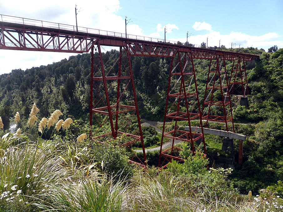
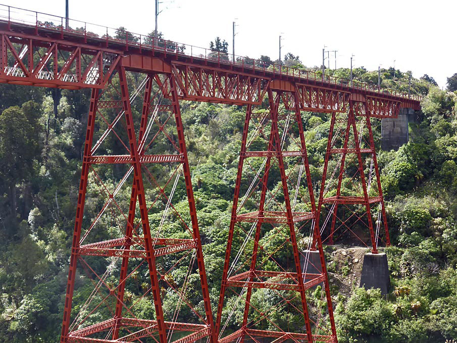
The Makatote Viaduct, built between 1905 and 1908, was the last and highest structure constructed on the NIMT, and was therefore vital to its completion. The design of the Makatote Viaduct, with its superstructure that features five central tall, latticed, steel piers, is representative of the time it was built and showed an awareness of international developments in engineering. A testimony to the technical skill demonstrated in its construction is the superstructure has remained relatively unchanged, although some additions to the viaduct in the 1920s and 1980s were necessary as part of broader changes in the operation of the NIMT. In the late 20th and early 21st centuries the viaduct's two tallest central piers also needed remedial underpinning to enable the ongoing viability of the structure.
The viaduct gains much of its significance as an engineering feat in its own right. An indication of the scale of the project is that a large community had to be established for the viaduct's construction. The Makatote Viaduct generated immense public interest at the time of its construction, and despite the decline of rail transport, its monumentality and dramatic setting has meant it has continued to delight and awe people. Originally the Makatote ranked among the highest viaducts in the world and was the highest in New Zealand. Consequently, it is considered an icon of the NIMT and 20th century New Zealand engineering, as well as a significant, prominent, landmark in the Central Plateau.
List Entry Information
Status
Listed
List Entry Status
Historic Place Category 1
Access
Private/No Public Access
List Number
7778
Date Entered
20th February 2009
Date of Effect
20th February 2009
City/District Council
Ruapehu District
Region
Horizons (Manawatū-Whanganui) Region
Extent of List Entry
Extent includes part of the land described as the NIMT rail corridor and the structure known as the Makatote Viaduct thereon, including its abutments (Refer to map in Appendix 1 of the registration report for further information).
Legal description
NZ Gazette 1910, pp.596-597
Location Description
The viaduct bridges the Makatote Gorge 12km south of National Park, between Pokaka and Erua. There are viewing areas for motorists on State Highway 4 (SH4) between Pokaka and Erua at a rest stop beneath the southern piers of the viaduct, and also from the Makatote Scenic Reserve at the northern end of the viaduct.
Why is this place significant?
Cultural Significance
Social Significance or Value: The Makatote Viaduct is an important and impressive structure within the NIMT and had social significance at the time it was constructed as an icon of New Zealand's progress and development. Since its completion the viaduct has continued to be symbolic of the importance of the railway to the local community, and even with the decline of rail transport the Makatote Viaduct has maintained its status as a source of pride and wonder for the residents of, and travellers in, the region as well as rail enthusiasts nationally.
Historic Significance
Historical Significance or Value The Makatote Viaduct has considerable historic importance both nationally and locally, primarily because it was the last structure built on, and enabled the completion of, the NIMT. The construction of the NIMT took 23 years and was only made possible because of the agreement of some Maori to allow surveying in, and eventually the establishment of the railway corridor through, the restricted area of the Rohe Potae. This access initiated one of the most expensive state projects undertaken in New Zealand; expenditure which was justified by the governments of the time as a means of gaining a foothold in the King Country, of encouraging immigration to New Zealand, and stimulating settlement in the central North Island, as well as forging a direct route from Wellington to Auckland. The NIMT also promised to create huge economic benefit upon completion, and by 1908 this motivator hinged on the timely and successful completion of the Makatote Viaduct. Therefore, this viaduct is a pivotal structure in the history of New Zealand. The viaduct also has historical value because it is the only structural evidence which remains of the huge construction effort and large community at the Makatote site during the viaduct's construction. Until rail's transportation pre-eminence was surpassed by road in the late 20th century, the Makatote Viaduct proved to be a vital link for the local and national economy, with a significant amount of passenger and freight transported across it. The structural alterations to the viaduct over time reflect the major changes in rail operational practices over the 20th century, and are indicative of the importance placed on maintaining the structure to ensure it continued to be a viable part of the NIMT.
Physical Significance
Technological Significance or Value: The Makatote Viaduct is a monumental structure that is characteristic of the technological developments of its construction period and which enabled the establishment of railways across difficult landscapes. While steel truss viaducts were internationally, nationally, and regionally common, the terrain at Makatote and the scale of the viaduct makes it nationally unique among its contemporaries. Until 1939, the Makatote Viaduct was the highest in New Zealand and it is currently the third tallest. The contractor used innovative thinking to compensate for the magnitude of the construction task and the physical impediments of the site. The first of these was the unprecedented step for Andersons of establishing a permanent, modern, workshop at the site. The second and more technologically significant initiative was the use of the 'Blondin,' which within New Zealand was a distinguishing feature of the Makatote's construction. The structure's longevity, with only a few instances of strengthening, is a testament to the technical skill of the designer, contractor, and workforce. Professional esteem for their accomplishment has been demonstrated by the fact that the structure has stood the test of time and it has never been considered necessary to completely replace the structure, only to underpin it. The 2006-07 strengthening projects imbued Makatote with further national engineering significance and continued the tradition of innovative thinking and superior engineering standards associated with the viaduct. Aesthetic Significance or Value: The Makatote Viaduct is nationally recognised as having high aesthetic value as a monumental structure set within a dramatic landscape which is flanked on either side by views of Mt Ruapehu and Mt Taranaki. Aside from the majestic natural features of the Central Plateau, the viaduct is one of the most prominent landmarks in the area. The vertical features of the tall, slender, steel piers combined with the horizontal line of the viaduct's deck, forms an elegant and impressive structure. The silhouette of the viaduct, particularly when viewed from the tight curve of SH4 at the eastern end of the gorge, is a visually pleasing contrast to the organic forms of the surrounding landscape from which the viaduct emerges. Since its completion the Makatote Viaduct has consistently been photographed and described because it has inspired admiration and awe. This feeling is predominant from all the vantage points of the viaduct, but especially the rest stop under the southern piers, and from the elevated view afforded at the Makatote Scenic Reserve to the north of the viaduct.
Why is this place Category 1 / Category 2?
Detail Of Assessed Criteria
(a) The extent to which the place reflects important or representative aspects of New Zealand history: The Makatote Viaduct is a physical remnant of the enormous engineering feat which was the construction of the NIMT. This railway was the main arterial transport route for freight and passenger traffic for most of the 20th century. The Makatote Viaduct was, and still is, an integral functioning part of the NIMT and its history. (b) The association of the place with events, persons, or ideas of importance in New Zealand history: An initial important association for the Makatote area is with John Rochfort who spent considerable time in the vicinity to complete the survey of the route for the NIMT. Later, his hut close to the Makatote site was used by engineers doing preliminary work on the viaduct. Because it was designed by Peter Seton Hay, the Engineer-in-Chief of the Public Works Department, the Makatote Viaduct also has an association with this important engineer and the other structures he designed during his career. Incidentally, this career was cut short as a result of Hay dying from an illness contracted during a tour of NIMT construction projects which included his only visit to the Makatote viaduct site. The construction company, J & A Andersons Ltd, also features significantly in New Zealand engineering history. It was one of the earliest firms established, and undertook numerous important projects during which they were eager to use up-to-date and innovative techniques and technologies. The founder was also an important personality in the development of Christchurch. Due to the Makatote Viaduct being the last major structure completed on the NIMT it is an essential component in the history of the railway, and more particularly, the 'final push' to complete it. The viaduct also featured largely in the 1908 completion celebrations and again during the centenary celebrations in 2008. (e) The community association with, or public esteem for the place: Even before its completion, the Makatote Viaduct loomed large in the people's imaginations. Despite the diminishing of rail transport's prominence, the viaduct has continued to intrigue people and the hoards of rail enthusiasts present at the site during the 2008 'Parliamentary Special' Celebrations is evidence of this, as is the consistent written and photographic depictions of the viaduct throughout its history. Because there is almost a 360 degrees range for views of the viaduct from SH4, combined with its monumentality, it is a popular landmark in the Central Plateau. (f) The potential of the place for public education: Currently there is signage at the southern rest stop which details the 2006-07 underpinning project. However, there is great potential for further interpretation about the history of the viaduct's construction (the large community it took, the innovative techniques used etc.), its seminal importance to the completion of the NIMT, and its place within the broader context of the settlement in the Central Plateau. Appropriate sites for this interpretation could be the southern rest stop, and/or at the northern end of the viaduct in the Makatote Scenic Reserve. The Makatote Viaduct is situated close to the Manganui-o-te-ao memorial to the NIMT's 'Last Spike' and can also be linked to other recognised NIMT 'final push' heritage structures in the region, such as the Raurimu Spiral and Ohakune to Horopito Old Coach Road, and other viaducts in the vicinity like the Old Hapuawhenua. This grouping of a series of recognised and related heritage structures in close proximity has the potential to form the basis of a local historic rail route. (g) The technical accomplishment or value, or design of the place: From an engineering and design standpoint, the Makatote Viaduct is deemed to be of considerable technical. This viaduct is recognised nationally as an accomplishment with its inclusion in the IPENZ Engineering Heritage Register, and in the quantities of written material which discuss the Makatote Viaduct. Likewise, the retention of the viaduct and the recent innovative techniques used to ensure its ongoing viability as a functioning component of the NIMT, speak to its status as a distinct engineering feat within the larger accomplishment of the NIMT. (k) The extent to which the place forms part of a wider historical and cultural complex or historical and cultural landscape: The Makatote Viaduct is a significant element in the historical and cultural landscape of the Central Plateau area and the North Island because of its association with the history of NIMT which was the basis of settlement in the region. Summary of Significance or Values: This place was assessed against, and found to qualify under the following criteria: a, b, e, f, g, and k. Conclusion: It is considered that this place qualifies as a Category I historic place. The Makatote Viaduct was the last major obstacle in the push to complete the largest single construction project in New Zealand's history, the NIMT. This railway directly affected the physical and social landscape of the Central Plateau and was integral in the development of New Zealand's economy. The NIMT is a significant engineering feat which is representative of the technologies and best engineering practices of the time. Within this there are several individual structures that are comparable to the Makatote Viaduct in construction material, designer, and/or construction company which have been singled out as remarkable structures by the New Zealand Historic Places Trust. These are the (Old) Hapuawhenua, Makohine, and Waiteti viaducts, all of which are registered as Category I historic places. Despite commonalities with these structures, the Makatote is considered an outstanding example and engineering masterpiece because it was the highest viaduct in New Zealand until surpassed by the Mohaka Viaduct in 1939. The viaduct's monumental height was necessary in crossing one of the most dramatic and, therefore until then, remote landscapes in the Central Plateau. This presented the construction company with a number of unique challenges which they solved by establishing a significant on-site operation staffed by the populous of the large temporary Makatote township, and the use of the most modern techniques and technology available including the innovative and unprecedented use of the Blondin as a construction tool. The aesthetic appeal of the viaduct's impressive scale set within a spectacular natural setting, which includes views of Mounts Ruapehu and Taranaki on either side, has contributed to the Makatote Viaduct's status as a key landmark of the area. The viaduct has consistently captured the imaginations people, the result being that it is probably one of the most photographed structures in the area and also one of the most written about railway structures in New Zealand.
Construction Professional
Name
J & A Anderson Ltd
Type
Builder
Biography
The New Zealand engineering firm of Anderson Limited (later J & A Anderson Ltd) was established in 1850 by John Anderson who was one of the first Canterbury settlers. He built the first New Zealand-made steam engines 1857, together with wool presses and a variety of machinery and mechanical components. By 1877 the firm was involved in railway engineering and construction in the South Island. The Waiteti Viaduct contract was the first involvement of his sons John and Andrew in major construction work, and it was their first major work in the North Island. They later built the Manganui-a-te-Ao and Mangaturuturu bridges and the Makatote Viaduct on the North Island Main Trunk railway.
Name
Hay, Peter Seton
Type
Designer
Biography
Peter Seton Hay (1852/1853? - 1907) was born in Glasgow, Scotland, probably in 1852 or 1853, the son of Janet (Jessie) Dalziel and her husband, James Johnston Hay, a journeyman engineer. When Peter was a child the family emigrated to New Zealand, arriving at Port Chalmers on the Storm Cloud in April 1860. Educated in Dunedin, he was the first graduate of the newly established University of Otago, obtaining a BA in 1877 and an MA with first-class honours in mathematics in 1878. In June 1875 on the advice of a university teacher he had joined the Public Works Department as an engineering cadet. After completing his studies he was engaged in railway surveys and construction for the lines from Dunedin to Moeraki and Clinton. In the early 1880s he was employed on Central Otago railway surveys from Rough Ridge to Hawea, in the Cromwell district, and from Balclutha to the Catlins River. Hay's reputation as a brilliant young engineer was established in these Otago days. Stories were told of his prodigious mental calculations when he was working in the field without the usual aids such as logarithm tables. In 1884 Hay was transferred to the head office of the Public Works Department in Wellington. He began his steady progress through the ranks of the department, and two years later was promoted to resident engineer. In 1896 he was promoted to superintending engineer, equivalent to assistant engineer-in-chief. By then the construction of the North Island main trunk rail link was the foremost Public Works Department project. Hay helped plan most of the important railway works of the central North Island section and was responsible for the primary design of the Makohine, Mangaweka, Hapuawhenua, Taonui, Manganui-a-te-ao and Makatote viaducts. By any standards the viaducts were great works of engineering. Much of the credit for their construction must be attributed to Peter Hay. Hay succeeded W. H. Hales as engineer-in-chief of the Public Works Department in 1906, only to die in office on 19 March 1907. He suffered the effects of exposure while inspecting the main trunk railway works near Waiouru, and subsequently died from pleurisy at his home in Wadestown, Wellington. He was aged 54. One of Hay's major achievements was his investigation and report on the proposed Southern Alps rail crossing by the Midland railway in 1903. The scheme recommended by the government's American advisory engineer, Virgil Gay Bogue, required a 3½-mile tunnel and a steep gradient incline track. Hay's scheme, which was ultimately adopted, avoided expensive grading and track work but required a tunnel over five miles long. This tunnel, at Otira, was completed in 1923, long after Hay's death. Equally important was Hay's contribution to the development of hydroelectric power generation in New Zealand. Peter Seton Hay married Mary Clarke at Wairuna, Otago, on 22 April 1879 and they had four sons and one daughter. His wife and children survived him. Hay was the first New Zealand-trained engineer to rise to the rank of engineer-in-chief. He died at the height of his powers and before many of his projects had been completed. Although his life was relatively brief, his works endured. Lowe, Peter. 'Hay, Peter Seton 1852/1853? - 1907'. Dictionary of New Zealand Biography, updated 16 December 2003 URL: http://www.dnzb.govt.nz/
Construction Details
Start Year
1905
Type
Other
Description
Site preparation started at Makatote Viaduct. Construction of Makatote Workshop begun.
Start Year
1906
Type
Original Construction
Description
Workshop completed and steel fabricating begins. Anderson family builds house and moves to site.
Start Year
1906
Type
Original Construction
Description
June/July Formation and excavation work on northern pier footings begin
Start Year
1906
Type
Original Construction
Description
August Construction proper on the viaduct begins
Start Year
1907
Type
Original Construction
Description
January Excavations for southern piers begins. Abutments, concrete piers, and their girders, and all, concrete bases, except for central pier, are complete.
Start Year
1908
Type
Original Construction
Description
January All piers completed. 10 July Makatote Viaduct complete. Workshop and accommodation are dismantled and permanent track laid across viaduct.
Start Year
1925
Finish Year
1932
Type
Modification
Description
Strengthening of spans
Start Year
1959
Type
Modification
Description
Micaceous iron oxide top coat painted on steel superstructure
Start Year
1981
Finish Year
1982
Type
Modification
Description
Underpinning of pier 6/F and some of the concrete piers
Start Year
1986
Type
Modification
Description
Way beans replaced in preparation for electrification. Electrification masts added
Start Year
1997
Type
Other
Description
Painting of some piers and spans
Start Year
2006
Finish Year
2007
Type
Modification
Description
Underpinning of pier 7/G
Construction Materials
Steel, concrete, and timber
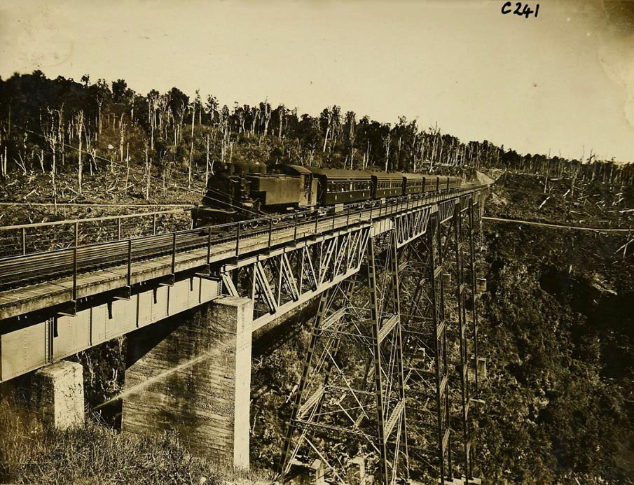
The Makatote Viaduct, built between 1905 and 1908, is one of the engineering icons of the North Island Main Trunk (NIMT) and bridges the Makatote River between Pokaka and Erua in the North Island's picturesque Central Plateau. It was the last structure built on the NIMT and was therefore vital in the 'final push' to complete the railway. Settlement through sleepers and steel: The completion of the NIMT in late 1908 is described as '...one of the pivotal moments in New Zealand history' and '...arguably the New Zealand state's greatest achievement, at least in the first century after 1840, and certainly its greatest financial commitment.' The impetus for the NIMT was the need to create a direct link between New Zealand's two major cities, Auckland and Wellington. For 20 years prior to the NIMT's completion, goods and passenger traffic between these cities was typically directed from Auckland to New Plymouth via coastal shipping, then continued by ship or train onto Wellington and vice versa. However, another motivator for the railway was for it to act as a means of Europeans gaining access to the sealed-off King Country, or Rohe Potae, and in turn establish settlements which could support the railway and exploit the vast, and relatively untouched, resources of the Central Plateau region. From the mid-1860s Maori in the central North Island had repelled European encroachment by establishing, and staunchly upholding, the restricted area known as the Rohe Potae. After a decade of persistent approaches from the government regarding the area, talks between officials and some King Country chiefs regarding the establishment of the railway through their land began in earnest in 1883. A series of rigorous negotiations was then initiated with two Ngati Maniapoto leaders, Wahanui Hautare and Rewi Maniapoto. In late 1884 Wahanui announced his intention to cooperate with the government regarding the railway, and he laid out a set of conditions before the House of Representatives on 1 November 1884. He did this because he wanted any European encroachment into the area to be on iwi's terms, which included the right of the King movement to manage their own affairs, the banning of liquor from Waikato-Ngati Maniapoto territory, the right of his people to have sole responsibility for administering their ancestral lands, and that they were compensated for the land which was used. Following this, in early 1885 surveyors were allowed into the Rohe Potae to locate possible railway routes. Because of the tenuous relationship between the Crown and King Country iwi it was felt that the negotiation process was essential. However, by only consulting with Wahanui and Maniapoto the government purposely side-stepped King Tawhiao and other leaders who opposed the railway. Therefore, this initial agreement was not universal and accordingly there were instances of resistance, such as the destruction of surveying marks. Despite some opposition, surveying and construction plans continued and on 15 April 1885 it was Wahanui who wielded the shovel that turned the NIMT's first sod, which was then ceremonially wheeled away by Premier Robert Stout. Prior to the chiefs allowing surveyors into the Rohe Potae, possible railway corridors through the King Country were only speculative because there had not been any previous opportunity to map it in detail. There were several proposed routes for the NIMT and John Rochfort (1832-1893) surveyed for a possible corridor through the Central Plateau between 1883 and 1887. This was said to be his tour de force because he had to start from scratch and cover a large, and topographically complex, area. Rochfort must have spent a significant amount of time around the Makatote Gorge because he built a hut. This hut, referred to as ‘Rochfort's old whare,' was close to the Makatote Viaduct site and was still in use 20 years later. After much debate and delay it was Rochfort's route for the NIMT that was eventually followed. The Maori land that this route required progressively passed into Crown ownership under the Public Works Acts of 1882 and 1894. This legislation stipulated that construction could not begin until the governor issued a proclamation detailing the middle-line that each successive section would take. Once the route was resolved and the required land obtained, the construction progress of the NIMT laboured along, taking 23 years to complete due to various political and financial impediments including the depression of the 1890s. By 1900 public dissatisfaction over the prolonged construction period motivated parliament to inject significantly more resources to the project, and facilitating a final flurry of activity to see the last section between the Makohine Viaduct and Taumarunui completed. Within this area the section between Ohakune and Raurimu, in particular, was no easy task despite the boost in funding and manpower, because of the rugged terrain which was noted for its steep grades, deep ravines, and heavy bush, not to mention the often inclement weather. Given the topography it is not surprising that this ‘final push' section has a concentration of significant structures. These include the Makatote and three other surviving viaducts, and important earthworks of which the Raurimu Spiral is an internationally recognised engineering achievement. The Makatote Gorge is a prime example of the deep ravines which scar the landscape west of Mount Ruapehu and in 1903 it was described as: ...a deep and narrow gorge to be spanned with a great viaduct - a giant ravine that will never grow anything but the rimu, matai, maire, and under-growth with which its precipitous sides are now clad. The bush in this wonderful gorge...will constitute one of the principal attractions of the Waimarino section of the Main Trunk line. At some points the depth of the gorge is approximately 300 ft (92m), but a lower point was chosen for the site of the viaduct which means it is 258ft (79m) tall. Even so, until 1981 the Makatote Viaduct was the highest structure on the NIMT, and is currently the third tallest viaduct in New Zealand. The monumentality of the viaduct and its setting within an equally dramatic landscape ‘...commands considerable awe - perhaps more than any other New Zealand railway structure.' Bridging the gap: Constructing the Makatote Viaduct: The Makatote Viaduct looms up from unseen depths with its five tapering piers of rigid steel...This structure has often been described both in these columns and elsewhere, and photographs of every stage of its erection are to be seen. Yet no pictures and no descriptions can reduce it to a commonplace. It stands, and it will stand, it is hoped, for many years as our finest monument of structural engineering. It ranks in height among the great viaducts. In the beauty of its situation it acquires enhanced significance. The Makatote Viaduct, and its other NIMT contemporaries, are products of the iron and steel construction age of the late 19th and early 20th centuries which saw the building of iconic structures such as the Crystal Palace (1851), and Gustave Eiffel's steel viaducts and Eiffel Tower (1889). The industrial revolution demanded the development of construction materials which were long lasting, relatively light, and could be mass produced, and iron and steel fulfilled these criteria. However, it was not until the late 19th century that a technique was developed which reduced the cost of steel production and made it as cost effective as iron. As a consequence of the international railway boom engineers, such as Eiffel, pioneered the construction of steel viaducts. From this period, steel fabrication was favoured for viaducts, and other large self-supporting structures. In particular, lightness was important for viaducts ‘because it is only in such structures that the weight of the metal forms a prominent item in the strains.' Consequently, the Makatote Viaduct was constructed using steel and was described as an ‘Eiffel Tower among viaducts' because of its monumental scale and trestle construction. Aside from being constructed in steel, the lightness of the Makatote is said to also be a tribute to the ‘skilful and bold work of its designer.' The fabric and design of the Makatote Viaduct makes it a characteristic structure of the period, although it is an extraordinary example because of its impressive scale. The engineer responsible for designing the Makatote Viaduct, and many other dynamic NIMT structures, was Peter Seton Hay. Hay is noteworthy because he was the first person to graduate from the University of Otago with a Bachelor of Arts in 1877. He then joined the Public Works Department (PWD) and gradually progressed through its ranks to become the engineer-in-chief by the time he died prematurely in 1907. Hay's designs for the NIMT construction era Makohine, Mangaweka, Hapuawhenua, Taonui, Manganui-o-te-ao, Mangaturuturu, and Makatote viaducts were all based on classic North American trestle viaducts and are recognised, alongside his pioneering research into New Zealand's hydroelectric capabilities, as his most important legacies. The Makatote's design is derived from the one Hay used at Mangaweka, which differed from Makohine because it included plate girders over the piers which were interspersed with lattice truss spans to create a more visually pleasing structure. The Mangaweka Viaduct was demolished when the Mangaweka deviation was built in the early 1980s. This means that the Makatote Viaduct is the only remaining large scale Hay viaduct of this design. Hay is said to have made his first and only visit to the Makatote construction site while taking a general tour of the works in the area. On this occasion, Peter Keller, a young up-and-coming engineer with the PWD, recorded that ‘the weather was atrocious and he [Hay] got a real soaking.' Apparently, Hay already looked ill and died of pneumonia not long after this visit, which unfortunately meant that he did not live to see the Makatote Viaduct, one of his finest achievements, completed. Although some preliminary site work was done by the PWD, the Makatote Viaduct was constructed by a private engineering firm from Christchurch, J & A Anderson Ltd. This company was awarded the contract for the large sum of £53,369 in 1905 and the plans were signed-off at the end of June. The letting of the contract for the ‘largest work of its kind carried out in New Zealand by private enterprise' to that date, was well in advance of the railheads reaching Makatote because it was recognised that in order for the NIMT to progress steadily significant structures needed to be complete by the time track was laid up to them. Andersons was a well established firm, and was awarded the contract on the basis of their previous experience constructing railways and viaducts in the South Island, and also on the NIMT having built the Te Kuiti to Mokau section 1887-89, which included the Waiteti Viaduct. The construction of major projects, such as the Makatote Viaduct, relied on a huge amount of manual labour, so communities sprung up around them. In general the advent of the NIMT injected Europeans into the area, but also affected the demographic spread of the region's pre-construction population. In particular, it has been noted that after 1900 the various Maori settlements around the Manganui-o-te-ao River were depopulated. This is because many gained employment as labourers on the NIMT and then gravitated towards the newly established European towns once their work was completed. Therefore, until construction for the Makatote Viaduct began, there was no existing substantial permanent settlement within the immediate vicinity of the viaduct site. There was a settlement at the north end of the viaduct and is it reported to have included the workers tents and huts and ‘a sprinkling of accommodation houses, stores, and refreshment rooms, all of the primitive architecture characteristic of the transitory township....' It is estimated that there were approximately 400 to 500 people living around the Makatote site, most of who worked on the viaduct and were immigrants from Britain or Australia, in accordance with Vogel's plan. The size of the community was relatively large for the region at this time, even compared with established permanent settlements. For example, Ohakune's population in 1908 consisted of approximately 600 people. As well as the temporary tent and hut accommodation used by the workers, Andrew Anderson, the junior partner of the firm, built a house on site for he and his family to live in from 1906 until the viaduct's completion. Andrew's nieces visited often and the high profile of the family and the project was demonstrated by their comings and goings being reported in society pages. The Andersons' house, next to the Makatote workshop, seems to have been the social centre of the community with dinner parties and the hosting of guests. Laura Anderson, the wife of Andrew, had pre-planned for the site's isolation by stocking up on essential supplies like first aid equipment and taking courses before leaving Christchurch. Because of this foresight she became the first port of call for medical treatment in the community. The size of the Makatote community fluctuated depending on the phase of construction and increased late in the construction period because of the sense of urgency to get it completed in time for the late 1908 deadline set by the government. One of the first injections of labour was during the building of the access road by the PWD, which because it was not started early enough delayed proceedings by at least 6 months. Other special facilities also needed to be built, such as a workshop for the fabricating of the superstructure. The Makatote workshop was situated immediately north of the viaduct, featured cutting edge machinery for the time, and was fully electrified. Temporary onsite workshops were standard practice for Andersons and had been an aspect of PWD viaduct projects like the Makohine. However, because of unsuitable site access at Makatote it was necessary to manufacture all the steelwork on site. Therefore, the Makatote workshop (built 1905-06) was more elaborate and larger, at 285 x 30ft (87 x 9m) in size, than their previous ones and was also used for the manufacturing the superstructures of the two other Andersons constructed viaducts in the vicinity. Unlike planned towns along the NIMT, Makatote was not meant to be permanent, so upon completion the workshop and accommodation structures were dismantled. The Makatote community, therefore, was a significant example of the fluid and transitory nature of the population in the district between 1900 and 1908. Because the community disbanded this means that the viaduct is the only remaining complete physical remnant and tribute at the site to what was the intense manual labour effort to complete it and the NIMT. During construction there was huge public interest in the progress of the NIMT, and Makatote in particular, and as such we find numerous and lengthy descriptions of it in newspapers. One article from June 1907detailed the ingenious technique used by Andersons to tackle the challenge of erecting this high viaduct: The marvel to the lay mind is that these huge steel girders are being placed in position by swinging them out in the blue ethereal on 2 ½ inch wire rope...Objects are swung out by attaching them to a wheel and pulley arrangement working along the wire and called a traveller, or, more picturesquely, a Blondin. A winding engine works the Blondin backwards and forwards, and when the Blondin is over the desired spot, its freight is lowered to the level required. Sometimes a bucket with a human freight is attached to the Blondin. What must it feel like working 200 hundred odd feet in midair, with enough drop beneath you to accommodate two Grand Hotels one on top of the other, or three Government Buildings? The ‘picturesque' name for the technique was taken from the famous French Niagara Falls tightrope walker, Charles Blondin. This technology was essential to the completion of the viaduct as it overcame the difficulty of building a tall and reasonably long viaduct in an unsympathetic landscape. Construction of the viaduct began in mid-1906 with the clearing of the bush and excavating for the piers. However, aside from the delay caused by the late construction of the service road, Andersons faced other problems. Difficulties posed by the landscape were overcome using the Blondin, but the biggest hindrance during construction was the weather. For example, it was reported that in September 1907 there was no fewer than 28 rainy days at Makatote. Also, on at least one occasion in 1906 the river flooded which resulted in the destruction of the flume and delayed work by several weeks while it was repaired. Another cause of delay was geological because pier 7/G was found to have a ‘rotten foundation.' This was overcome by driving the footing deeper into the ground. However, the time taken in gaining permission to change the plan and in undertaking the additional concrete work affected the progress of erecting the piers. Aside from these factors workers, many of whom lived in tents or flimsy wooden PWD huts, had to contend with freezing winter temperatures and treacherous work conditions which for seven men resulted in death after they slipped off the icy steelwork. These challenges meant that the contract eventually ran one year over the stipulated time, and incurred some criticism from anxious politicians and the public. The actual structural work for the viaduct dates from August 1906 when the northern-side concrete piers and pier footings were poured so that work could begin on erecting the steel piers. This meant that by February 1907, piers 811/H-K were constructed, however, the foundation work for the piers on the opposite bank had only been started the month previous. Around this time F.W. Furkert succeeded J.J. Hay as Resident Engineer for the area, and the significant construction progress during 1907 was attributed and his drive, efficiency, and management skills. Indeed, from mid-1907 work at Makatote, in particular, seems to have progressed well with most of the piers completed and some of the spans in place by the end of the year. It then remained to complete pier 5/E and 6/F, the highest central pier, which was done by the end of January 1908. Work then began on positioning the girders using the Blondin as described previously. By late April 1908 the NIMT railhead was north of Makatote, which meant that all that stood in the way of the NIMT's completion was the viaduct. The last girder was placed in position on 7 June, with final touches completed soon after, such as coating the steelwork with haematite paint. Andersons declared the viaduct finished on 10 July 1908, and later that month a weight test was made using temporary tracks. Essentially all that was then needed was for the permanent track to be laid across it be the PWD. This had not been completed by the time the ‘Fleet Special,' otherwise known as the ‘Parliamentary Special,' train was due to make the inaugural uninterrupted train journey from Wellington to Auckland on 8 August 1908. This train stopped on the Makatote Viaduct, which seems to have been a particular highlight for the Premier Sir Joseph Ward. The clear day meant that he and the other passengers were afforded a view of Mount Ruapehu in one direction, and Mount Taranaki in the other. Maintaining an image: The Makatote Viaduct post-construction: The tremendous interest in the Makatote Viaduct during its construction carried on once the NIMT was complete and because of people's fascination with the structure there is a plethora of images available of the viaduct. The Makatote Viaduct became a ‘pin-up' structure for the Railways Department NIMT advertising campaigns from the 1940s to mid-1970s and, among other things, it featured in the cover image for the NIMT's 50th anniversary pamphlet. Over the years it has also been a source of reverence and interest among rail enthusiasts and tourist alike and many images have resulted. Among numerous accolades it has been said that: ‘Without doubt the Makatote is an engineering masterpiece of its time, a truly impressive structure built in harmony with its bush environment.' Even before it was completed, the aesthetic qualities of a viaduct set within such a dramatic landscape were appreciated and this eventually led to the establishment of the Makatote Scenic Reserve to the north of the viaduct in 1914. In 1977 it was estimated that ‘approximately one in ten cars stop at this viewpoint [the Makatote Scenic Reserve] to either picnic or view the viaduct, and of these cars approximately 50% of the people alight and take in the general scenery.' The cavalcade of cars and people lining the banks of the Makatote Gorge in order to glimpse the NIMT Centenary Celebration ‘Parliamentary Special' crossing the viaduct in August 2008, and also the release of a Makatote Viaduct stamp by New Zealand Post, is evidence of the continued appreciation for Makatote as an engineering feat and aesthetic highlight of the railway and state highway. Railway structures, like the Makatote Viaduct, were built and operated based around the principle of continuous improvement and repair when needed. Therefore additions and alterations to the viaduct are an integral part of its, and the NIMT's, story and reflect larger historical changes in railway operations and technology. In accordance, minor changes have been made to the Makatote since 1908, including re-coating the superstructure in 1959 and partially in 1997. However, there were four main periods of significant alteration to the structure. Along with other bridges and viaducts on the NIMT, the Makatote had its spans strengthened between 1925 and 1932 to ensure it could bear the heavier class of locomotive that was being introduced. Concern for the footing of the highest central pier meant that this was underpinned in 1981-82, as well as some other remedial work. It was another change in locomotives and technology that prompted further changes in 1986. At this time the way beams which supported the track were replaced and steel brackets to support electrification masts were constructed in preparation for NIMT electrification. The last significant addition to the Makatote Viaduct was the underpinning of pier 7/G between May 2006 and February 2007. It was about the time that pier 6/F was underpinned that assessments of the erosion at the footing of pier 7/G began. However, it was not deemed necessary to act until 20 years later. The resulting addition was important because it was done in order to maintain Makatote's structural integrity and ensure its ongoing viability as a functioning part of the NIMT. This pier had caused delay during the NIMT construction period because of its ‘rotten foundation,' and 100 years later it was causing problems again. The addition to the footing essentially transferred the strain on the pier's troublesome foundation onto the appendage which is visible from the SH4 southern rest stop. The restoration project was a collaborative venture between ONTRACK, Fulton Hogan Ltd and specialist engineering consultants to the sum of $4.2 million dollars. The price of completely replacing the viaduct would have been prohibitive when all that was needed to secure Makatote was to splint its Achilles' heel. Considerable time was spent conceiving the best means of stabilizing the via-duct and the eventual solution to build a new support structure along side the original pier footings won ONTRACK the Supreme Award for New Zealand Engineering Excellence 2007. The work was described as an example of ‘world best-practice in retrofitting...and makes a significant contribution to the reputation of New Zealand engineering.' The success of the project gained further esteem because all the work was completed while the viaduct was still open to rail traffic, and also because the environmental impact on river and its inhabitants was a central concern.
The Makatote Viaduct, built between 1905 and 1908, is one of the engineering icons of the North Island Main Trunk (NIMT) and bridges the Makatote River between Pokaka and Erua in the North Island's picturesque Central Plateau. It was the last structure built on the NIMT and was therefore vital in the 'final push' to complete the railway. Settlement through sleepers and steel: The completion of the NIMT in late 1908 is described as '...one of the pivotal moments in New Zealand history' and '...arguably the New Zealand state's greatest achievement, at least in the first century after 1840, and certainly its greatest financial commitment.' The impetus for the NIMT was the need to create a direct link between New Zealand's two major cities, Auckland and Wellington. For 20 years prior to the NIMT's completion, goods and passenger traffic between these cities was typically directed from Auckland to New Plymouth via coastal shipping, then continued by ship or train onto Wellington and vice versa. However, another motivator for the railway was for it to act as a means of Europeans gaining access to the sealed-off King Country, or Rohe Potae, and in turn establish settlements which could support the railway and exploit the vast, and relatively untouched, resources of the Central Plateau region. From the mid-1860s Maori in the central North Island had repelled European encroachment by establishing, and staunchly upholding, the restricted area known as the Rohe Potae. After a decade of persistent approaches from the government regarding the area, talks between officials and some King Country chiefs regarding the establishment of the railway through their land began in earnest in 1883. A series of rigorous negotiations was then initiated with two Ngati Maniapoto leaders, Wahanui Hautare and Rewi Maniapoto. In late 1884 Wahanui announced his intention to cooperate with the government regarding the railway, and he laid out a set of conditions before the House of Representatives on 1 November 1884. He did this because he wanted any European encroachment into the area to be on iwi's terms, which included the right of the King movement to manage their own affairs, the banning of liquor from Waikato-Ngati Maniapoto territory, the right of his people to have sole responsibility for administering their ancestral lands, and that they were compensated for the land which was used. Following this, in early 1885 surveyors were allowed into the Rohe Potae to locate possible railway routes. Because of the tenuous relationship between the Crown and King Country iwi it was felt that the negotiation process was essential. However, by only consulting with Wahanui and Maniapoto the government purposely side-stepped King Tawhiao and other leaders who opposed the railway. Therefore, this initial agreement was not universal and accordingly there were instances of resistance, such as the destruction of surveying marks. Despite some opposition, surveying and construction plans continued and on 15 April 1885 it was Wahanui who wielded the shovel that turned the NIMT's first sod, which was then ceremonially wheeled away by Premier Robert Stout. Prior to the chiefs allowing surveyors into the Rohe Potae, possible railway corridors through the King Country were only speculative because there had not been any previous opportunity to map it in detail. There were several proposed routes for the NIMT and John Rochfort (1832-1893) surveyed for a possible corridor through the Central Plateau between 1883 and 1887. This was said to be his tour de force because he had to start from scratch and cover a large, and topographically complex, area. Rochfort must have spent a significant amount of time around the Makatote Gorge because he built a hut. This hut, referred to as ‘Rochfort's old whare,' was close to the Makatote Viaduct site and was still in use 20 years later. After much debate and delay it was Rochfort's route for the NIMT that was eventually followed. The Maori land that this route required progressively passed into Crown ownership under the Public Works Acts of 1882 and 1894. This legislation stipulated that construction could not begin until the governor issued a proclamation detailing the middle-line that each successive section would take. Once the route was resolved and the required land obtained, the construction progress of the NIMT laboured along, taking 23 years to complete due to various political and financial impediments including the depression of the 1890s. By 1900 public dissatisfaction over the prolonged construction period motivated parliament to inject significantly more resources to the project, and facilitating a final flurry of activity to see the last section between the Makohine Viaduct and Taumarunui completed. Within this area the section between Ohakune and Raurimu, in particular, was no easy task despite the boost in funding and manpower, because of the rugged terrain which was noted for its steep grades, deep ravines, and heavy bush, not to mention the often inclement weather. Given the topography it is not surprising that this ‘final push' section has a concentration of significant structures. These include the Makatote and three other surviving viaducts, and important earthworks of which the Raurimu Spiral is an internationally recognised engineering achievement. The Makatote Gorge is a prime example of the deep ravines which scar the landscape west of Mount Ruapehu and in 1903 it was described as: ...a deep and narrow gorge to be spanned with a great viaduct - a giant ravine that will never grow anything but the rimu, matai, maire, and under-growth with which its precipitous sides are now clad. The bush in this wonderful gorge...will constitute one of the principal attractions of the Waimarino section of the Main Trunk line. At some points the depth of the gorge is approximately 300 ft (92m), but a lower point was chosen for the site of the viaduct which means it is 258ft (79m) tall. Even so, until 1981 the Makatote Viaduct was the highest structure on the NIMT, and is currently the third tallest viaduct in New Zealand. The monumentality of the viaduct and its setting within an equally dramatic landscape ‘...commands considerable awe - perhaps more than any other New Zealand railway structure.' Bridging the gap: Constructing the Makatote Viaduct: The Makatote Viaduct looms up from unseen depths with its five tapering piers of rigid steel...This structure has often been described both in these columns and elsewhere, and photographs of every stage of its erection are to be seen. Yet no pictures and no descriptions can reduce it to a commonplace. It stands, and it will stand, it is hoped, for many years as our finest monument of structural engineering. It ranks in height among the great viaducts. In the beauty of its situation it acquires enhanced significance. The Makatote Viaduct, and its other NIMT contemporaries, are products of the iron and steel construction age of the late 19th and early 20th centuries which saw the building of iconic structures such as the Crystal Palace (1851), and Gustave Eiffel's steel viaducts and Eiffel Tower (1889). The industrial revolution demanded the development of construction materials which were long lasting, relatively light, and could be mass produced, and iron and steel fulfilled these criteria. However, it was not until the late 19th century that a technique was developed which reduced the cost of steel production and made it as cost effective as iron. As a consequence of the international railway boom engineers, such as Eiffel, pioneered the construction of steel viaducts. From this period, steel fabrication was favoured for viaducts, and other large self-supporting structures. In particular, lightness was important for viaducts ‘because it is only in such structures that the weight of the metal forms a prominent item in the strains.' Consequently, the Makatote Viaduct was constructed using steel and was described as an ‘Eiffel Tower among viaducts' because of its monumental scale and trestle construction. Aside from being constructed in steel, the lightness of the Makatote is said to also be a tribute to the ‘skilful and bold work of its designer.' The fabric and design of the Makatote Viaduct makes it a characteristic structure of the period, although it is an extraordinary example because of its impressive scale. The engineer responsible for designing the Makatote Viaduct, and many other dynamic NIMT structures, was Peter Seton Hay. Hay is noteworthy because he was the first person to graduate from the University of Otago with a Bachelor of Arts in 1877. He then joined the Public Works Department (PWD) and gradually progressed through its ranks to become the engineer-in-chief by the time he died prematurely in 1907. Hay's designs for the NIMT construction era Makohine, Mangaweka, Hapuawhenua, Taonui, Manganui-o-te-ao, Mangaturuturu, and Makatote viaducts were all based on classic North American trestle viaducts and are recognised, alongside his pioneering research into New Zealand's hydroelectric capabilities, as his most important legacies. The Makatote's design is derived from the one Hay used at Mangaweka, which differed from Makohine because it included plate girders over the piers which were interspersed with lattice truss spans to create a more visually pleasing structure. The Mangaweka Viaduct was demolished when the Mangaweka deviation was built in the early 1980s. This means that the Makatote Viaduct is the only remaining large scale Hay viaduct of this design. Hay is said to have made his first and only visit to the Makatote construction site while taking a general tour of the works in the area. On this occasion, Peter Keller, a young up-and-coming engineer with the PWD, recorded that ‘the weather was atrocious and he [Hay] got a real soaking.' Apparently, Hay already looked ill and died of pneumonia not long after this visit, which unfortunately meant that he did not live to see the Makatote Viaduct, one of his finest achievements, completed. Although some preliminary site work was done by the PWD, the Makatote Viaduct was constructed by a private engineering firm from Christchurch, J & A Anderson Ltd. This company was awarded the contract for the large sum of £53,369 in 1905 and the plans were signed-off at the end of June. The letting of the contract for the ‘largest work of its kind carried out in New Zealand by private enterprise' to that date, was well in advance of the railheads reaching Makatote because it was recognised that in order for the NIMT to progress steadily significant structures needed to be complete by the time track was laid up to them. Andersons was a well established firm, and was awarded the contract on the basis of their previous experience constructing railways and viaducts in the South Island, and also on the NIMT having built the Te Kuiti to Mokau section 1887-89, which included the Waiteti Viaduct. The construction of major projects, such as the Makatote Viaduct, relied on a huge amount of manual labour, so communities sprung up around them. In general the advent of the NIMT injected Europeans into the area, but also affected the demographic spread of the region's pre-construction population. In particular, it has been noted that after 1900 the various Maori settlements around the Manganui-o-te-ao River were depopulated. This is because many gained employment as labourers on the NIMT and then gravitated towards the newly established European towns once their work was completed. Therefore, until construction for the Makatote Viaduct began, there was no existing substantial permanent settlement within the immediate vicinity of the viaduct site. There was a settlement at the north end of the viaduct and is it reported to have included the workers tents and huts and ‘a sprinkling of accommodation houses, stores, and refreshment rooms, all of the primitive architecture characteristic of the transitory township....' It is estimated that there were approximately 400 to 500 people living around the Makatote site, most of who worked on the viaduct and were immigrants from Britain or Australia, in accordance with Vogel's plan. The size of the community was relatively large for the region at this time, even compared with established permanent settlements. For example, Ohakune's population in 1908 consisted of approximately 600 people. As well as the temporary tent and hut accommodation used by the workers, Andrew Anderson, the junior partner of the firm, built a house on site for he and his family to live in from 1906 until the viaduct's completion. Andrew's nieces visited often and the high profile of the family and the project was demonstrated by their comings and goings being reported in society pages. The Andersons' house, next to the Makatote workshop, seems to have been the social centre of the community with dinner parties and the hosting of guests. Laura Anderson, the wife of Andrew, had pre-planned for the site's isolation by stocking up on essential supplies like first aid equipment and taking courses before leaving Christchurch. Because of this foresight she became the first port of call for medical treatment in the community. The size of the Makatote community fluctuated depending on the phase of construction and increased late in the construction period because of the sense of urgency to get it completed in time for the late 1908 deadline set by the government. One of the first injections of labour was during the building of the access road by the PWD, which because it was not started early enough delayed proceedings by at least 6 months. Other special facilities also needed to be built, such as a workshop for the fabricating of the superstructure. The Makatote workshop was situated immediately north of the viaduct, featured cutting edge machinery for the time, and was fully electrified. Temporary onsite workshops were standard practice for Andersons and had been an aspect of PWD viaduct projects like the Makohine. However, because of unsuitable site access at Makatote it was necessary to manufacture all the steelwork on site. Therefore, the Makatote workshop (built 1905-06) was more elaborate and larger, at 285 x 30ft (87 x 9m) in size, than their previous ones and was also used for the manufacturing the superstructures of the two other Andersons constructed viaducts in the vicinity. Unlike planned towns along the NIMT, Makatote was not meant to be permanent, so upon completion the workshop and accommodation structures were dismantled. The Makatote community, therefore, was a significant example of the fluid and transitory nature of the population in the district between 1900 and 1908. Because the community disbanded this means that the viaduct is the only remaining complete physical remnant and tribute at the site to what was the intense manual labour effort to complete it and the NIMT. During construction there was huge public interest in the progress of the NIMT, and Makatote in particular, and as such we find numerous and lengthy descriptions of it in newspapers. One article from June 1907detailed the ingenious technique used by Andersons to tackle the challenge of erecting this high viaduct: The marvel to the lay mind is that these huge steel girders are being placed in position by swinging them out in the blue ethereal on 2 ½ inch wire rope...Objects are swung out by attaching them to a wheel and pulley arrangement working along the wire and called a traveller, or, more picturesquely, a Blondin. A winding engine works the Blondin backwards and forwards, and when the Blondin is over the desired spot, its freight is lowered to the level required. Sometimes a bucket with a human freight is attached to the Blondin. What must it feel like working 200 hundred odd feet in midair, with enough drop beneath you to accommodate two Grand Hotels one on top of the other, or three Government Buildings? The ‘picturesque' name for the technique was taken from the famous French Niagara Falls tightrope walker, Charles Blondin. This technology was essential to the completion of the viaduct as it overcame the difficulty of building a tall and reasonably long viaduct in an unsympathetic landscape. Construction of the viaduct began in mid-1906 with the clearing of the bush and excavating for the piers. However, aside from the delay caused by the late construction of the service road, Andersons faced other problems. Difficulties posed by the landscape were overcome using the Blondin, but the biggest hindrance during construction was the weather. For example, it was reported that in September 1907 there was no fewer than 28 rainy days at Makatote. Also, on at least one occasion in 1906 the river flooded which resulted in the destruction of the flume and delayed work by several weeks while it was repaired. Another cause of delay was geological because pier 7/G was found to have a ‘rotten foundation.' This was overcome by driving the footing deeper into the ground. However, the time taken in gaining permission to change the plan and in undertaking the additional concrete work affected the progress of erecting the piers. Aside from these factors workers, many of whom lived in tents or flimsy wooden PWD huts, had to contend with freezing winter temperatures and treacherous work conditions which for seven men resulted in death after they slipped off the icy steelwork. These challenges meant that the contract eventually ran one year over the stipulated time, and incurred some criticism from anxious politicians and the public. The actual structural work for the viaduct dates from August 1906 when the northern-side concrete piers and pier footings were poured so that work could begin on erecting the steel piers. This meant that by February 1907, piers 811/H-K were constructed, however, the foundation work for the piers on the opposite bank had only been started the month previous. Around this time F.W. Furkert succeeded J.J. Hay as Resident Engineer for the area, and the significant construction progress during 1907 was attributed and his drive, efficiency, and management skills. Indeed, from mid-1907 work at Makatote, in particular, seems to have progressed well with most of the piers completed and some of the spans in place by the end of the year. It then remained to complete pier 5/E and 6/F, the highest central pier, which was done by the end of January 1908. Work then began on positioning the girders using the Blondin as described previously. By late April 1908 the NIMT railhead was north of Makatote, which meant that all that stood in the way of the NIMT's completion was the viaduct. The last girder was placed in position on 7 June, with final touches completed soon after, such as coating the steelwork with haematite paint. Andersons declared the viaduct finished on 10 July 1908, and later that month a weight test was made using temporary tracks. Essentially all that was then needed was for the permanent track to be laid across it be the PWD. This had not been completed by the time the ‘Fleet Special,' otherwise known as the ‘Parliamentary Special,' train was due to make the inaugural uninterrupted train journey from Wellington to Auckland on 8 August 1908. This train stopped on the Makatote Viaduct, which seems to have been a particular highlight for the Premier Sir Joseph Ward. The clear day meant that he and the other passengers were afforded a view of Mount Ruapehu in one direction, and Mount Taranaki in the other. Maintaining an image: The Makatote Viaduct post-construction: The tremendous interest in the Makatote Viaduct during its construction carried on once the NIMT was complete and because of people's fascination with the structure there is a plethora of images available of the viaduct. The Makatote Viaduct became a ‘pin-up' structure for the Railways Department NIMT advertising campaigns from the 1940s to mid-1970s and, among other things, it featured in the cover image for the NIMT's 50th anniversary pamphlet. Over the years it has also been a source of reverence and interest among rail enthusiasts and tourist alike and many images have resulted. Among numerous accolades it has been said that: ‘Without doubt the Makatote is an engineering masterpiece of its time, a truly impressive structure built in harmony with its bush environment.' Even before it was completed, the aesthetic qualities of a viaduct set within such a dramatic landscape were appreciated and this eventually led to the establishment of the Makatote Scenic Reserve to the north of the viaduct in 1914. In 1977 it was estimated that ‘approximately one in ten cars stop at this viewpoint [the Makatote Scenic Reserve] to either picnic or view the viaduct, and of these cars approximately 50% of the people alight and take in the general scenery.' The cavalcade of cars and people lining the banks of the Makatote Gorge in order to glimpse the NIMT Centenary Celebration ‘Parliamentary Special' crossing the viaduct in August 2008, and also the release of a Makatote Viaduct stamp by New Zealand Post, is evidence of the continued appreciation for Makatote as an engineering feat and aesthetic highlight of the railway and state highway. Railway structures, like the Makatote Viaduct, were built and operated based around the principle of continuous improvement and repair when needed. Therefore additions and alterations to the viaduct are an integral part of its, and the NIMT's, story and reflect larger historical changes in railway operations and technology. In accordance, minor changes have been made to the Makatote since 1908, including re-coating the superstructure in 1959 and partially in 1997. However, there were four main periods of significant alteration to the structure. Along with other bridges and viaducts on the NIMT, the Makatote had its spans strengthened between 1925 and 1932 to ensure it could bear the heavier class of locomotive that was being introduced. Concern for the footing of the highest central pier meant that this was underpinned in 1981-82, as well as some other remedial work. It was another change in locomotives and technology that prompted further changes in 1986. At this time the way beams which supported the track were replaced and steel brackets to support electrification masts were constructed in preparation for NIMT electrification. The last significant addition to the Makatote Viaduct was the underpinning of pier 7/G between May 2006 and February 2007. It was about the time that pier 6/F was underpinned that assessments of the erosion at the footing of pier 7/G began. However, it was not deemed necessary to act until 20 years later. The resulting addition was important because it was done in order to maintain Makatote's structural integrity and ensure its ongoing viability as a functioning part of the NIMT. This pier had caused delay during the NIMT construction period because of its ‘rotten foundation,' and 100 years later it was causing problems again. The addition to the footing essentially transferred the strain on the pier's troublesome foundation onto the appendage which is visible from the SH4 southern rest stop. The restoration project was a collaborative venture between ONTRACK, Fulton Hogan Ltd and specialist engineering consultants to the sum of $4.2 million dollars. The price of completely replacing the viaduct would have been prohibitive when all that was needed to secure Makatote was to splint its Achilles' heel. Considerable time was spent conceiving the best means of stabilizing the via-duct and the eventual solution to build a new support structure along side the original pier footings won ONTRACK the Supreme Award for New Zealand Engineering Excellence 2007. The work was described as an example of ‘world best-practice in retrofitting...and makes a significant contribution to the reputation of New Zealand engineering.' The success of the project gained further esteem because all the work was completed while the viaduct was still open to rail traffic, and also because the environmental impact on river and its inhabitants was a central concern.
Physical Description and Analysis: The Makatote Viaduct crosses the deep Makatote Gorge and its river on the North Island's Central Plateau. It serves a functioning and busy railway line and at its southern-end launches over SH4. Makatote is a trestle viaduct with five steel piers each supporting a steel plate girder span across their top, and five steel Pratt truss intermediate spans. The viaduct's abutments, pier footings, and the three flanking piers on each end are constructed from concrete. These last piers also carry steel plate girder spans. The decking is timber and the parapet, or railing, is steel. The viaduct has numerous prestressed concrete masts carrying the electric traction catenary attached to the outer edge on the western side. In total the Makatote Viaduct is 262m in length and 79m high. There is a considerable amount of original fabric present in the viaduct, primarily in its superstructure. The central piers are relatively unchanged from their 1906-08 construction dates, although the steel was repainted with a micaceous iron oxide top coat in 1959 and partially repainted again in 1997 which is the grey coating currently visible. The areas on the viaduct which have a reddish colour denote the presence of rust, red algae, or is where the grey coating has weathered and exposed the red lead primer of the 1959 paint. Other additions to the pier and footing fabric occurred in the early 1980s with the underpinning of pier 6/F. This included the insertion of two new 1800mm cylinders into the 1907 footings closest to the river, and the addition of prestressed concrete caps. At this time piers 3/C and 9/I underwent vertical prestressing and also had prestressed concrete pier caps added. The pier on the opposite side of the river, pier 7/G, was underpinned in 2006-07 with the addition of a new piled foundation attached to the base of the steelwork of the tower closest to the river. The addition is a 38m long concrete crossbeam supported by steel piles, with lateral stability provided by anchors constructed in the side of the gorge. The original fabric on this pier was not affected aside from where the steel was encircled by the crossbeam. The spans were strengthened in 1925-32. However it is unclear whether this significantly altered the original fabric. It is possible that new roll-steel joints were installed and the floor beams were strengthened. The deck of the viaduct has undergone the most complete changes to its fabric overtime. Aside from routine maintenance and replacement of the fabric of the decking, the way beams were completely replaced in 1986. The electrification masts were also added during that year but the parapet appears to be an original feature dating from 1908. The fabric of the viaduct's superstructure is relatively unchanged from its 1906-08 construction. Although the 2006-07 strengthening project added fabric to the base of pier 7/G and is a highly noticeable addition, this is negligible because it was essential in ensuring the overall structural integrity and viability of the viaduct. This and the other changes and additions to the viaduct over time are all indicative of the structure being maintained to ensure its ongoing feasibility and relevance within the functioning railway.
Physical Description and Analysis: The Makatote Viaduct crosses the deep Makatote Gorge and its river on the North Island's Central Plateau. It serves a functioning and busy railway line and at its southern-end launches over SH4. Makatote is a trestle viaduct with five steel piers each supporting a steel plate girder span across their top, and five steel Pratt truss intermediate spans. The viaduct's abutments, pier footings, and the three flanking piers on each end are constructed from concrete. These last piers also carry steel plate girder spans. The decking is timber and the parapet, or railing, is steel. The viaduct has numerous prestressed concrete masts carrying the electric traction catenary attached to the outer edge on the western side. In total the Makatote Viaduct is 262m in length and 79m high. There is a considerable amount of original fabric present in the viaduct, primarily in its superstructure. The central piers are relatively unchanged from their 1906-08 construction dates, although the steel was repainted with a micaceous iron oxide top coat in 1959 and partially repainted again in 1997 which is the grey coating currently visible. The areas on the viaduct which have a reddish colour denote the presence of rust, red algae, or is where the grey coating has weathered and exposed the red lead primer of the 1959 paint. Other additions to the pier and footing fabric occurred in the early 1980s with the underpinning of pier 6/F. This included the insertion of two new 1800mm cylinders into the 1907 footings closest to the river, and the addition of prestressed concrete caps. At this time piers 3/C and 9/I underwent vertical prestressing and also had prestressed concrete pier caps added. The pier on the opposite side of the river, pier 7/G, was underpinned in 2006-07 with the addition of a new piled foundation attached to the base of the steelwork of the tower closest to the river. The addition is a 38m long concrete crossbeam supported by steel piles, with lateral stability provided by anchors constructed in the side of the gorge. The original fabric on this pier was not affected aside from where the steel was encircled by the crossbeam. The spans were strengthened in 1925-32. However it is unclear whether this significantly altered the original fabric. It is possible that new roll-steel joints were installed and the floor beams were strengthened. The deck of the viaduct has undergone the most complete changes to its fabric overtime. Aside from routine maintenance and replacement of the fabric of the decking, the way beams were completely replaced in 1986. The electrification masts were also added during that year but the parapet appears to be an original feature dating from 1908. The fabric of the viaduct's superstructure is relatively unchanged from its 1906-08 construction. Although the 2006-07 strengthening project added fabric to the base of pier 7/G and is a highly noticeable addition, this is negligible because it was essential in ensuring the overall structural integrity and viability of the viaduct. This and the other changes and additions to the viaduct over time are all indicative of the structure being maintained to ensure its ongoing feasibility and relevance within the functioning railway.
Historical and Associated Iwi / Hapū / Whānau
Completion Date
25th January 2009
Report Written By
Karen Astwood
Information Sources
Appendices to the Journals of the House of Representatives (AJHR)
Appendices to the Journals of the House of Representatives
Alexander Turnbull Library
Alexander Turnbull Library, Wellington
Archives New Zealand (Wgtn)
Archives New Zealand (Wellington)
Dictionary of New Zealand Biography
Dictionary of New Zealand Biography
Evening Post
Evening Post, 27 Jun 1919, p.7.
Grey River Argus
Grey River Argus
New Zealand Freelance
New Zealand Freelance
Otago Witness
Otago Witness
Waitangi Tribunal
Waitangi Tribunal Report, www.waitangi-tribunal.govt.nz
Wanganui Herald
Wanganui Herald
Taranaki Herald
'New Chapel at Mangorei', Taranaki Herald, 16 Oct 1869, p. 2.
Hawera & Normanby Star
Hawera & Normanby Star, 22 May 1915, p.1;
ONTRACK
ONTRACK Wellington
Other Information
This structure forms part of the operational railway. Trespassing on the rail premises and/or rail infrastructure is prohibited as trains may pass at any time without warning. Pursuant to the Railways Act 2005, a person must not enter any railway infrastructure or any railway premises without first obtaining a formal written Permit to Enter from the rail premises or access provider. Opus International Consultants won the Structural Heritage Award at the 2017 Institution of Structural Engineers' (IStructE) Structural Awards for their refurbishment of the Makatote Rail Viaduct. This place is included on the Engineering New Zealand Engineering Heritage Register. A fully referenced registration report is available from the NZHPT Central region office. Please note that entry on the New Zealand Heritage List/Rarangi Korero identifies only the heritage values of the property concerned, and should not be construed as advice on the state of the property, or as a comment of its soundness or safety, including in regard to earthquake risk, safety in the event of fire, or insanitary conditions.
Current Usages
Uses: Transport
Specific Usage: Bridge/ Viaduct
Former Usages
General Usage: Transport
Specific Usage: Bridge/ Viaduct
Themes
North Island Main Trunk Line
Web Links
description: Makatote Viaduct - Engineering NZ
url: https://www.engineeringnz.org/programmes/heritage/heritage-register/makatote-viaduct/
Location
Related listings
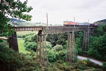
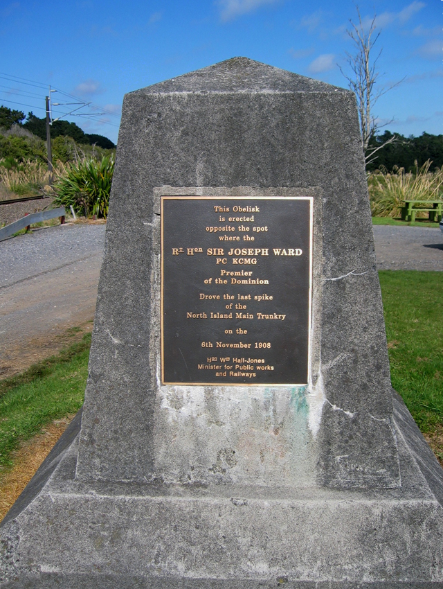
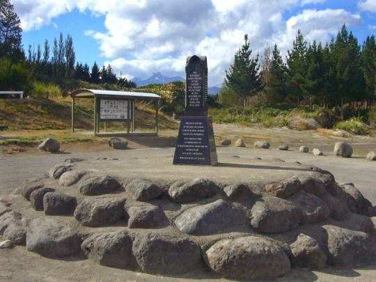
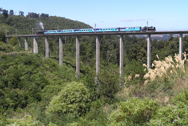
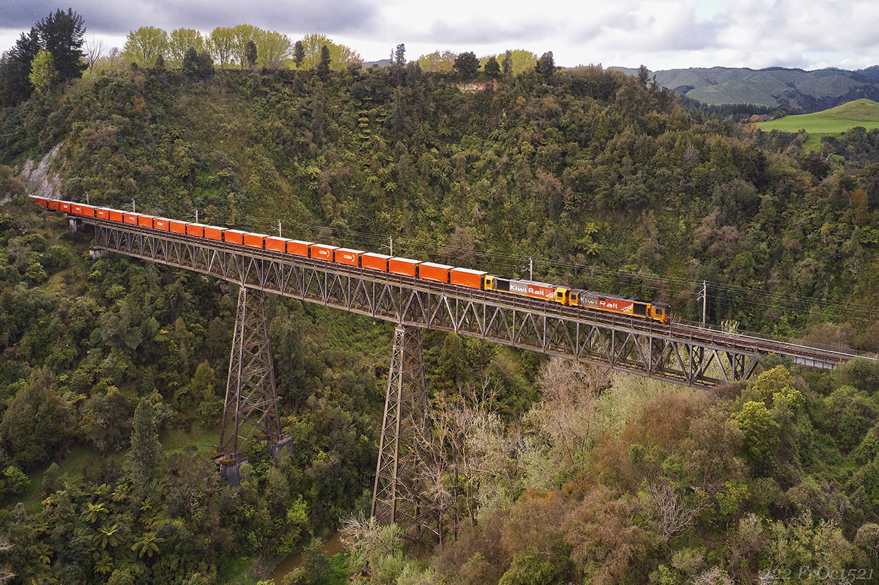
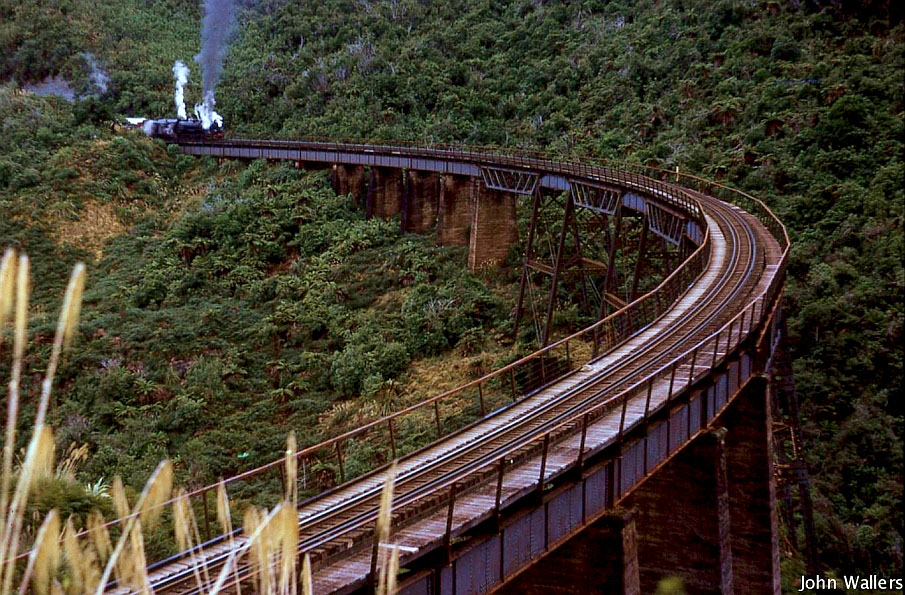
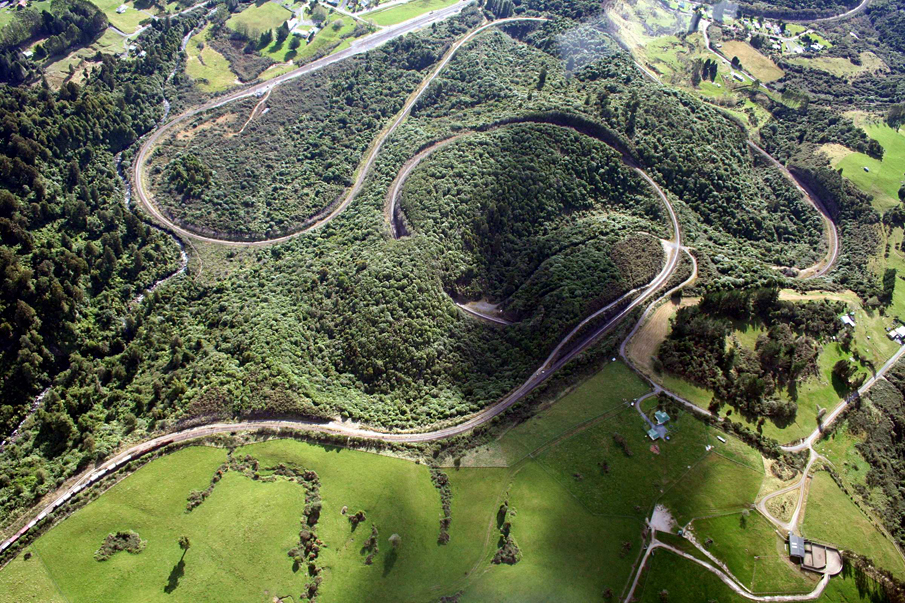
Sign up to hear more
Get the latest heritage news, features and events delivered
straight to your inbox.
