

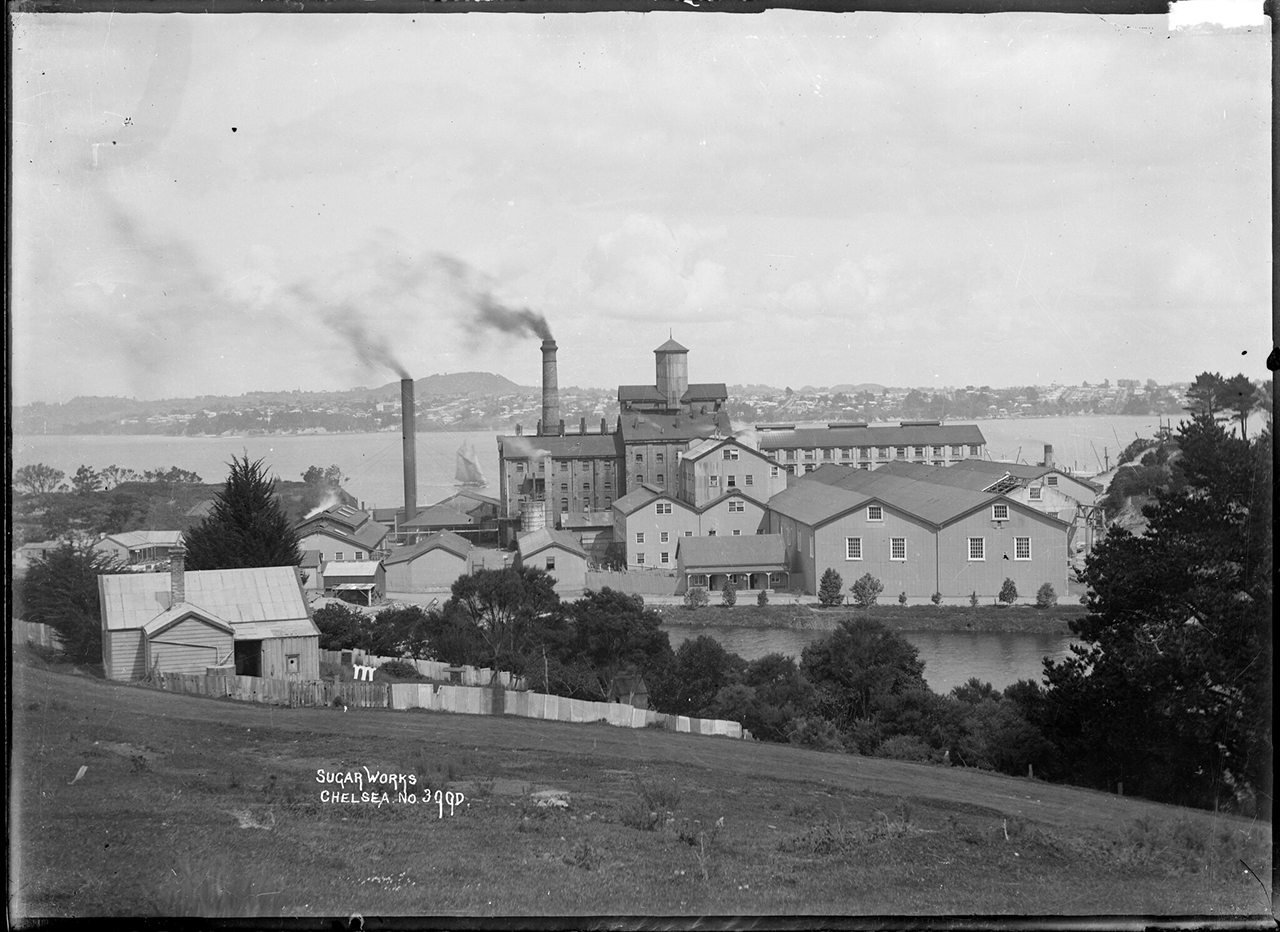
In 1881-3 the C.S.R. and its consortium purchased some 76 hectares (187 acres) at Duck Creek, attracted by the site's deep water anchorage and fresh water supply. The C.S.R.'s involvement occurred during a period of expansion for the company, which included establishing sugar-growing estates in Fiji. Located closer to this new source of sugar than Australian refineries, the new complex was to be part of an international trading network, importing and refining the raw product from these estates before distributing it throughout New Zealand. Construction initially involved extensive earthmoving and other works, designed by the Auckland-based firm of Boylan and Lundon. The industrial complex itself was probably designed by the C.S.R's James Muir, a significant figure in Australasian refinery construction. Over £30,000 was spent on wages for construction workers, a major investment for a private concern.
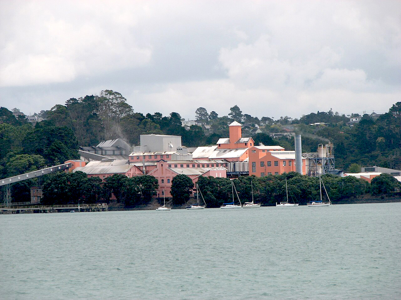
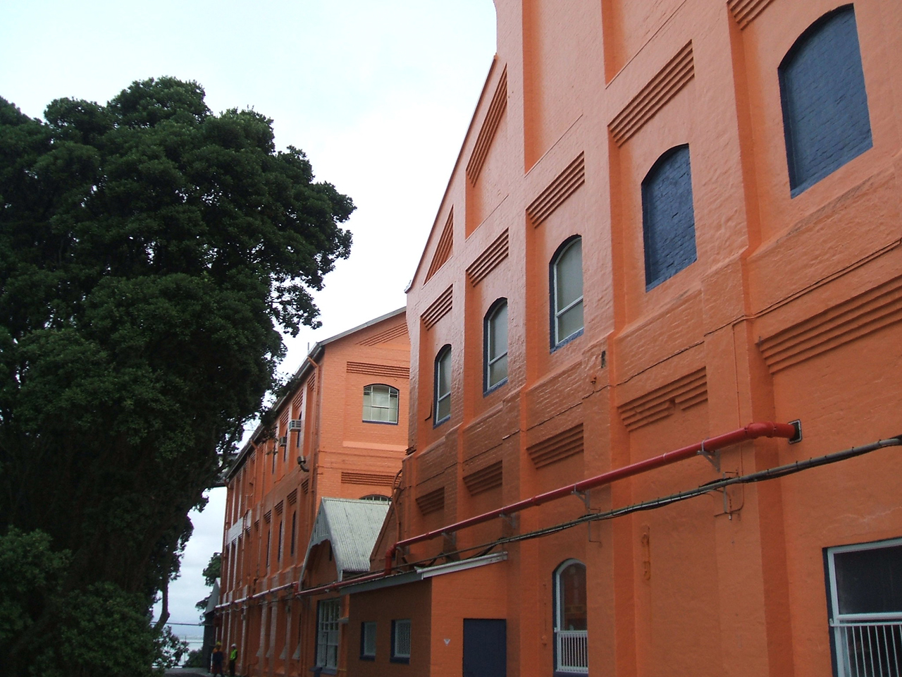
The factory was operational by September 1884 and may have been of unusual or innovative design. It incorporated a conjoined network of raw and refined sugar stores, a tall central cistern house and char kiln house, and a refinery and boiler room. Ancillary elements included wharves, tramways, workshops and offices. The enterprise emphasised self-sufficiency from the outset, exemplified by the production of one and a half million bricks from excavated clay on the site to build the main refinery structures. Elsewhere on the estate, two dams fed the refinery with water and a company town was created for some 100 workers. This contained 35 timber houses, a shop, a day school and an Anglican church. Separate accommodation close to the refinery was supplied for the works manager and a customs officer.
Creation of the refinery had an immediate impact on its surrounding area, with land values doubling. In spite of an economic depression after 1885, the neighbouring settlement at Birkenhead grew to service the refinery and its workforce. Re-named Chelsea by the late 1880s, the works expanded considerably at the turn of the century, employing nearly 250 workers in spite of growing mechanisation. By the early 1900s, the C.S.R. was the largest industrial organisation in Australia.
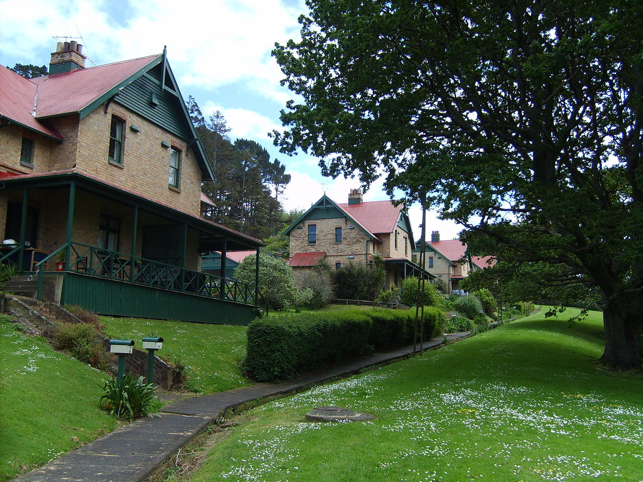
As well as expanding the factory complex, the company made considerable changes to the estate. These included removing the company town and replacing it with four large brick structures, each with two semi-detached dwellings for essential workers (1909). A large and ornate brick manager's house was also built to the west of the refinery (1908), perhaps reflecting reduced contact between the manager and his workforce. This occurred during a period of strained industrial relations. Greater public use of the estate may be indicated by the construction of a new passenger wharf next to the refinery and the beautification of the area through the planting of both native and exotic trees.
Further labour disputes in the 1920s included an extended strike that affected related manufacturing businesses across New Zealand. At a similar time, the indentured labour system in Fiji was abandoned and sugar was imported to Chelsea from all over the world. Construction of the Auckland Harbour Bridge (1959) and increasing mechanisation dramatically altered the working environment from the mid twentieth century. In the 1960s, as self-service supermarkets developed, the Chelsea brand was created to promote consumer loyalty and subsequently became a household icon. By the end of that decade, parts of the estate had been sold for residential housing. In 2008 a large part of the remnant was transferred into public hands. The refinery remains in use as a working factory, producing refined sugar and other goods. The broader estate is now a public park.
The Chelsea Sugar Refinery and Estate has aesthetic significance for its visual qualities, including its distinctive appearance, parkland setting and location beside the Waitemata Harbour. It has archaeological and architectural value as the only sugar refinery in New Zealand, which is able to demonstrate unique methods of industrial production and other aspects of workplace activity. The place can be considered to have cultural value for its association with the Chelsea brand. It has historical significance for its connections with the international sugar trade and the C.S.R., at one time Australia's largest industrial organisation. Strongly connected with its local community, the Chelsea Sugar Refinery and Estate has social value as a place of employment (and more latterly recreation) for 125 years. The place is technologically important for its unique equipment, including char cisterns, and for demonstrating rare or unusual technological processes from the 1880s and later.
List Entry Information
Status
Listed
List Entry Status
Historic Place Category 1
Access
Able to Visit
List Number
7792
Date Entered
26th June 2009
Date of Effect
26th June 2009
City/District Council
Auckland Council
Region
Auckland Council
Extent of List Entry
Extent includes the land described as Lot 110 DP 120843 (Recreational Reserve), Lot 1 DP 405428 (RT 422650), Lot 2 DP 405428 (RT 422651), Lot 3 DP 405428 (RT 422652), Lot 4 DP 405428 (road reserve), Lot 5 DP 405428 (RT 422654), Lots 1 and 2 DP 120844 (Local Purpose Reserve (Esplanade)), Lot 4 DP 21430 (RT NA113A/3) and part of Pt Bed Waitemata Harbour SO 67176 (Foreshore and Seabed Act 2004), all North Auckland Land District and the buildings and structures and setting known as the Chelsea Sugar Refinery and Estate thereon, and their fittings and fixtures, and the following chattels: timber moulds for metal castings. (Refer to Map 1 in Appendix 1 of the registration report for further information). A list of significant trees has been included in Appendix 4: this is not comprehensive and does not cover the full place assessed for registration. Notable fixtures and fittings include equipment such as the 1880s char cisterns in the Cistern House, and the works clock in the Electrical Shop. They also include cast iron kitchen ranges in the Manager's House and in two of the Workers' Houses.
Legal description
Lot 110 DP 120843 (Recreation Reserve), Lot 1 DP 405428 (RT 422650), Lot 2 DP 405428 (RT 422651), Lot 3 DP 405428 (RT 422652), Lot 4 DP 405428 (road reserve), Lot 5 DP 405428 (RT 422654), Lots 1 and 2 DP 120844 (Local Purpose Reserve (Esplanade)), Lot 4 DP 21430 (RT NA113A/3) and part of Pt Bed Waitemata Harbour SO 67176 (Foreshore and Seabed Act 2004), all North Auckland Land District
Why is this place significant?
Cultural Significance
Cultural Significance or Value: The place has cultural value for its close visual and manufacturing associations with the Chelsea brand of sugar, an iconic product in New Zealand. The brand logo incorporates an image of the Cistern house, promoting strong identification between Chelsea sugar and its place of production. Social Significance or Value: The place has social significance as a place of employment for 125 years, and for its strong links to the local community fostered through company-sponsored events including an annual picnic held for some six decades from the late 1880s. The place also has social significance for the company's tangible contribution to the development and welfare of the local community through measures such as the provision of low interest loans to its workers for house purchase or construction in the decades after 1910. It also has social significance as a place of recreation and public amenity for much of the twentieth century after having been planted with trees and beautified.
Historic Significance
Historical Significance or Value The place has historical significance for its associations with the international sugar trade, and the development of global commerce and diet. It has particularly strong links with the development of the C.S.R, at one time the largest industrial business in Australia. The place is strongly connected with the development of sugar plantations in Fiji and the sugar industry's use of large industrial working estates. It is also of value for its associations with the Auckland business community, the expansion of colonial markets and the histories of labour relations and gender in New Zealand. It also has important historical connections to the specific development of Birkenhead, and to the earlier development and settlement of Auckland and the North Shore. It has links with early colonial farming and rural estates, and is connected with several significant early colonial individuals.
Physical Significance
Aesthetic Significance or Value: The place has aesthetic significance for its notable visual qualities, including the distinctive appearance of the main refinery buildings, its parkland setting and its location beside the Waitemata Harbour. The place has strong landmark values, being visible and distinctive when viewed from the southern shores of the Waitemata harbour, from the Auckland Harbour Bridge and from streets in Northcote and Birkenhead. It incorporates buildings with well-preserved and notable ornate external and internal detailing, including the former Manager's House and Workers' Housing. Archaeological Significance or Value: The place has archaeological significance for incorporating the extensive physical remnants of the only manufactory of its type in New Zealand. It is important as a well-preserved nineteenth-century and early twentieth-century industrial landscape, incorporating a large factory complex, ancillary features such as dams and wharves, and workers' housing. It also contains the buried remnants of a nineteenth-century company town and possibly other features such as pre-refinery housing, agricultural systems, tented encampments, brickmaking and boatbuilding activity. It may contain deposits linked with Maori and other pre-1883 activity beneath extensive foreshore and other reclamation. Architectural Significance or Value: The place has significance as the only example of sugar refinery architecture in New Zealand, and as one of comparatively few surviving nineteenth-century examples in Australasia. Its former Manager's House and Workers' Housing have architectural significance for reflecting Australian architectural influences translated to a New Zealand location. Technological Significance or Value: The place has technological significance for its inclusion of unusually extensive industrial engineering works, including earthmoving, reclamation, water storage, waste disposal and brick building construction. The main refinery and its ancillary features are particularly important as the only place in New Zealand to reflect the development of sugar refining, a technological process that contributes to the manufacture of many foodstuffs and other materials. It includes buildings, machinery and chattels that demonstrate rare or unusual technical processes from the 1880s and later. It is associated with a range of technologies from sugar production to bag- and sack-making, coopering, boatbuilding and brickmaking.
Why is this place Category 1 / Category 2?
Detail Of Assessed Criteria
(a) The extent to which the place reflects important or representative aspects of New Zealand history: The place reflects important aspects of New Zealand history including colonial links with Australia and Great Britain; the emergence of New Zealand as a colonial market and producer; and the history of labour relations in New Zealand. It reflects the increasing industrialisation of New Zealand in the 1880s, the activities of the Auckland business community, and broader issues such as approaches to self-sufficiency. It has outstanding importance as one of few businesses to reflect changing industrial and other work practices in the same place for 125 continuous years. (b) The association of the place with events, persons, or ideas of importance in New Zealand history: The place is associated with persons of importance in New Zealand including the Premier Frederick Whitaker and poet James K. Baxter. Whitaker was a major investor in the sugar works and a Director of the New Zealand Sugar Company, formed to create the refinery. Of national stature, Baxter worked briefly at the refinery in the 1960s, producing a poem called 'Ballad of the Stonegut Sugar Works'. Prominent nineteenth-century businessmen Thomas Russell and James Williamson are also associated with the creation of the refinery and estate as major early investors. The place is linked with events of some significance including a strike with national impact in the 1920s. Regarded as part of the launch pad for an assault on settlements south of the Waitemata Harbour, the place has significant associations with Ngati Whatua's conquest of the Tamaki area in the early eighteenth century. (c) The potential of the place to provide knowledge of New Zealand history: The place has outstanding potential to provide knowledge about New Zealand history through physical examination of the place as an unusually large and well-preserved historic landscape. It has potential to provide knowledge about a range of topics, including manufacturing, trade, transport, labour organisation and residential life. It has particular potential to provide knowledge about the development of colonial industrial activity and New Zealand's role in the international sugar trade. Incorporating large areas of reclaimed land over tidal wetland and the foreshore it may also provide evidence about Maori and pre-colonial activity along the shoreline. It may also provide information about early colonial farming in these areas and elsewhere. (e) The community association with, or public esteem for the place: The place can be considered to have strong community association as a place of local employment for 125 years. It also enjoys strong public esteem for including a popular public amenity, with part of it having been taken into public ownership after a local campaign. (f) The potential of the place for public education: The place can be considered to have outstanding potential for public education because of its state of preservation, its proportion of land in public ownership, its proximity to centres of population, its appealing surroundings and its association with a well-known and popular brand and foodstuff. It is the only landscape in New Zealand to be able to relate the story of sugar production and its role in international, national and regional history. (g) The technical accomplishment or value, or design of the place: The place has special technical value for the quality and endurance of the industrial refining complex, with many of its buildings having been in continuous operation for 125 years. It has outstanding technical value as the only place in New Zealand to contain specialist technology linked with the nineteenth-century sugar-refining industry. It may also be significant as an early refinery internationally to incorporate attached raw sugar stores. (j) The importance of identifying rare types of historic places: The place has outstanding importance as one of few surviving nineteenth-century sugar refineries in Australasia, and of these it appears to be among the best-preserved. It is the only sugar refinery in New Zealand. (k) The extent to which the place forms part of a wider historical and cultural complex or historical and cultural landscape: The place forms part of a significant and extensive historical and cultural landscape within and along the north shore of the Waitemata Harbour. It directly adjoins extensive lands with well-preserved archaeological remains at Kauri Point and is close to important cultural sites such as Te Mata (Boat Rock). The place is integral to an understanding of the nineteenth-century urban landscape in neighbouring Birkenhead, which developed largely as a result of the creation of the refinery. Summary of Significance or Values: This place was assessed against, and found it to qualify under the following criteria: a, b, c, e, f, g, j, k. Conclusion: It is considered that this place qualifies Category I historic place. The place is considered to qualify as a Category I historic place because it is the only sugar refinery in New Zealand and one of few surviving nineteenth-century sugar refineries in Australasia. Of these it is likely to be one of the best-preserved. The place has special technical value for the quality and endurance of the industrial refining complex, with many of its buildings having been in continuous operation for 125 years. It also has outstanding technical value as the only place in New Zealand to contain specialist technology linked with the nineteenth-century sugar-refining industry. It may be an early refinery internationally to incorporate attached raw sugar stores. The place is further considered to qualify as a Category I historic place because it incorporates an unusually large and well-preserved historic landscape, with outstanding potential to provide knowledge about topics such as manufacturing, trade, transport, industrial and residential organisation. It has particular potential to provide knowledge about New Zealand's role in the international sugar trade and the development of colonial industrial activity. The place is the only landscape in New Zealand to be able to relate the story of sugar production and its role in international, national and regional history. It also has outstanding importance as one of few businesses to reflect changing industrial and other work practices in the same place for 125 continuous years.
Construction Details
Start Year
1883
Finish Year
1884
Type
Original Construction
Description
No.1 and No. 2 Dams; road; bridges; permanent company town; manager's house; relocated customs officer house.
Start Year
1885
startYearCirca
Type
Addition
Description
Factory fence; raw sugar store addition; possibly carpenter and blacksmith's shops; possibly cookhouse, stables and watchman's hut outside fence.
Start Year
1885
Type
Original Construction
Description
St Peter's Anglican church erected
Start Year
1887
Type
Modification
Description
Square pagoda at top of cistern house replaced by octagonal tower
Start Year
1889
Type
Modification
Description
Fencing erected
Type
Addition
Description
Expansion of factory: widened cutting; further reclamation; bag-making shop and printing house; treacle house and laboratory; large coal shed; raw sugar store extension; char house extension;
Period
pre-1898 (circa)
Type
Addition
Description
Cooper's shed; bale shed; sack shed; sack maker's house, dining room and boat slip.
Period
pre-1898 (circa)
Start Year
1899
Type
Original Construction
Description
Passenger wharf built
Start Year
1900
Type
Addition
Description
New melting house; small raw sugar store extension
Start Year
1900
startYearCirca
Type
Other
Description
Planting programme initiated on estate.
Start Year
1901
Type
Modification
Description
Widened cutting; removal of earlier carpenter's shop; extensions on west and north sides of raw sugar store.
Start Year
1901
Type
Original Construction
Description
No. 3 Dam construction
Start Year
1901
startYearCirca
Type
Modification
Description
Large carpenter's shop; engineer's store and fitting shop. Engineer's store and fitting shop replaced by treacle house and tinsmith's shop. New gateway into compound flanked by box-making department and bale shed.
Start Year
1903
Type
Modification
Description
Raw sugar store: large northward extension
Start Year
1904
startYearCirca
Type
Modification
Description
Refined sugar store extension (east end)
Start Year
1905
Type
Modification
Description
Bale shed and box-making departments extensions; shipping wharf extension
Start Year
1906
Type
Modification
Description
Enclosed sack carrier between sugar store and lighter wharf; refined sugar store extension (west end)
Start Year
1907
Type
Modification
Description
Manager's office replaced by larger building; weighbridge repositioned. St Peter's Anglican Church moved to Birkdale
Start Year
1907
Finish Year
1908
Type
Other
Description
Reclamation to south of No.3 Dam
Type
Addition
Description
Large boarding house built to east of factory complex. Also a smaller stable block and an engineer's office constructed
Period
pre-1908
Type
Other
Description
Likely seasonal or other Maori settlement at Wawaroa
Period
pre-1840
Type
Other
Description
Farmstead, garden and orchards (Gundry)
Period
late 1840s
Start Year
1845
startYearCirca
Finish Year
1855
finishYearCirca
Type
Other
Description
Possible brick making structures (Callan)
Start Year
1855
startYearCirca
Type
Other
Description
Temporary whare, kauri dwellings, barn, stables, stockyard, bakery, poultry and rabbit establishments, fencing and seven grass paddocks: possibly an expansion of the Gundry farmstead (d'Auvergne/Grut)
Type
Other
Description
House and fields, possibly incorporating Callan structures (Aickin)
Period
pre-1868
Type
Other
Description
Mud house (McCrum)
Period
pre-1882
Start Year
1883
Finish Year
1884
Type
Original Construction
Description
Construction of Chelsea Sugar Refinery: cutting and reclamation; main factory (raw sugar store, cistern house, char house, bone shed, refinery, boiler house and refined sugar store), waterfront structures
Start Year
1883
Finish Year
1884
Type
Original Construction
Description
(office building, combined workshop and store, and separate wharves for sugar and coal); ancillary features (including a gasometer and a network of tramlines); temporary tent village
Start Year
1909
startYearCirca
Type
Original Construction
Description
Company village dismantled. Four brick buildings, each with two semi-detached dwellings
Start Year
1912
Type
Modification
Description
Lighter wharf extension; foreshortened coal wharf; cooperage and waterside workers' dining room on jetty
Start Year
1914
startYearCirca
Type
Demolished - prior building
Description
1883-4 waterfront workshop demolished; replaced by brick building housing treacle and golden syrup store on ground floor and hessian storage, bag, case and tin making above. Single-storey laboratory probably also built
Start Year
1917
Type
Original Construction
Description
No. 4 Dam constructed
Start Year
1927
Type
Modification
Description
Main wharf jetty (north part)
Start Year
1947
Type
Relocation
Description
Waterside workers' amenities building; weighbridge moved to eastern side of covered way and new weighbridge office built. New offices and carpenter's shop (eastern part of complex)
Start Year
1954
Type
Modification
Description
Main chimney stack reduced in height
Start Year
1955
startYearCirca
Type
Modification
Description
New passenger wharf and westward extension of shipping wharf
Start Year
1957
Type
Modification
Description
Weigh tower and conveyor system erected to north of main wharf for raw sugar. Weighbridge and weighbridge office constructed in northwest part of compound, close to new building for despatch of refined sugar
Start Year
1958
Type
Modification
Description
Crane and grab installed on main wharf, with conveyor system to sugar store
Start Year
1960
Type
Modification
Description
Alterations to electrician's workshop
Start Year
1961
Type
Demolished - Other
Description
Main chimney demolished
Start Year
1963
startYearCirca
Type
Original Construction
Description
New bulk sugar store built, involving cutting a large terrace to west of complex
Start Year
1964
Type
Other
Description
Reclamation of No. 3 Dam started
Type
Other
Description
Sack conveyor, coal wharf and boat slip dismantled
Period
pre-1965
Start Year
1965
Type
Original Construction
Description
Emergency pump house built next to No. 4 Dam
Start Year
1966
Type
Other
Description
Proposed conversion of temporary watersiders' amenities building for drum handling
Type
Modification
Description
Western part of lighter wharf replaced by narrow walkway
Period
pre-1968
Start Year
1972
Type
Original Construction
Description
Large refined products warehouse and weighbridge built in northwest part of compound
Start Year
1974
Type
Other
Description
Grove of 100 Kauri planted
Type
Modification
Description
Weighbridge office converted to gate office
Period
pre-1976
Start Year
1883
startYearCirca
Type
Demolished - Fire
Description
Destruction by fire of possibly pre-1883-4 Custom's Officer's house in 1970s
Start Year
1977
Type
Modification
Description
Large extension to raw sugar store built, involving removal of possible pre-1883-4 engineer's house
Start Year
1982
Type
Modification
Description
Major development including silo
Type
Modification
Description
Passenger wharf removed
Period
pre-1983
Start Year
1985
Type
Original Construction
Description
Customer sales and distribution office erected close to gate office
Start Year
1986
Type
Other
Description
Shipwright's shed removed
Start Year
1987
Type
Modification
Description
Office extension and roading added
Start Year
1988
Type
Modification
Description
New bollard structure replaced eastern end of lighter wharf
Start Year
1998
Type
Modification
Description
Powdered sugar and blending facilities built within No.2 Warehouse
Start Year
2002
startYearCirca
Type
Demolished - additional building on site
Description
Demolition of Bag store
Start Year
2003
Type
Original Construction
Description
Decolorisation plant erected
Start Year
2007
Type
Modification
Description
Replacement of raw sugar store roof
Start Year
2009
Type
Other
Description
Dismantling of 1951 boiler station chimney
Start Year
1908
Type
Modification
Description
Large molasses tank; melt house extensions; cistern house extensions; shipping wharf extensions; raw sugar store extensions (north end). New manager's house
Construction Materials
Chelsea Sugar Refinery: various, including brick with corrugated iron roof (Cistern House, Char House, Waterside Workers) - timber and concrete (wharf), basalt (sea wall revetments) Manager's House: various including brick with corrugated iron roof (main dwelling and small outhouse), timber and wire mesh (aviaries x 2) Workers' Housing: brick with corrugated iron roof Dams No's 1-3: earth, brick and concrete Dam No.4: earth, brick and stone (basalt) Sea revetment: stone (basalt) Wharf remnants: timber
Early history of the site: The northern shores of the Waitemata Harbour are of significance to several iwi, having been explored or occupied since early human arrival in New Zealand. According to oral tradition, the Arawa canoe under Tama Te Kapua investigated the Waitemata after first arriving at Maketu. The canoe deposited a rock brought from Hawaiki on Te Mata (Boat Rock), an island to the west of Chelsea Bay. Such was the importance of this site that the Waitemata is believed to have been named after it. The Tainui canoe also landed a few miles to the east at Te Hau Kapua (Torpedo Bay) in present-day Devonport before travelling to its eventual heartland in the Waikato. By the eighteenth century, land in the vicinity of present-day Birkenhead was occupied by Kawerau, a smaller iwi who held settlements along the Waitemata shoreline noted for their access to shark fisheries. Evidently known as Wawaroa, the peninsula and inlet that forms the core of the current Chelsea Estate is believed likely to have contained settlement, which may have been seasonal or otherwise. Maori occupation has been recorded at most bays and headlands immediately to the east and west of the site, including at Uruamo, Onewa (Kauri Point), Onetaunga (Quarryman's Bay). In the 1740s, the Chelsea Bay shoreline between Hinemoa Street and Colonial Road - part of which lies within the Chelsea Estate - is regarded as having been occupied by a visiting Ngati Whatua taua (war party) of some 70 men, who used it as a base to launch an attack on Te Waiohua strongholds on the southern side of the Waitemata at Te To (Freemans Bay), Tokapurewa (Orakei) and Taurarua (Judge's Bay). The overwhelming success of the taua marked the last stage in the transfer of the Tamaki (Auckland) area from Te Waihoua to Ngati Whatua. The latter subsequently occupied pa sites on the North Shore, although Kawerau, who owed homage to Ngati Whatua, appear to have retained at least one coastal stronghold. Following Ngapuhi incursions in the 1820s, much of the north shore of the Waitemata was depopulated, assisting its purchase by the British Crown after formal colonisation in 1840. Early colonial land division and use: The land occupied by the current Chelsea Estate formed part of a large block between Mahurangi and the Waitemata that was obtained by the Crown in 1841. Located only a short distance away from the new colonial capital at Auckland, early subdivisions near Birkenhead were particularly sought after by local investors and speculators. From 1843 onwards, Crown Grants were issued for land that became part of the current Estate. Their survey and sale marked a radical reconceptualising of the landscape to include straight property boundaries and a network of projected roads for landward access, some of which remain in use to the present day (2009). Initial purchasers included the important early mercantile firm of Brown and Campbell and an Auckland-based chemist and grocer, William Gundry, who had married Makarita Rautangi, a daughter of the Ngāi Tūpoto leader, Te Reti Whatiia, a signatory of the Treaty of Waitangi at Mangungu (1840). The earliest owner of another property was evidently a local land agent, Richard Ridings, although the New Zealand Company - which had founded settlements at Wellington, New Plymouth and elsewhere - may have previously held an interest. Formal settlement was probably underway by the late 1840s with both horticultural and industrial enterprises potentially in existence beside the Wawaroa inlet, now renamed Duck Creek. Perhaps following Maori precedents in supplying the Auckland market, grocer William Gundry planted an orchard of apple, pear, cherry, plum and other trees on the promontory between Duck Creek and the main waterfront sometime after 1845. Described as his 'favourite retreat', buildings were in place by 1854 including a weatherboard house. This enterprise foreshadowed the creation of a fruit industry in Birkenhead, which was to form a mainstay of the area's economy into the twentieth century. Industrial enterprise may have occurred on land to the north of Duck Creek, which was purchased in 1846 by land agent and brickmaker Phillip Callan. Advertisements promoting Callan's 'Mill-manufactured bricks' for sale on the Auckland waterfront in December 1850, references to 'buildings and improvements' on Callan's land by March 1851, and the naming of the Duck Creek shoreline as Callan's Bay by later in the same year all indicate potential activity during this period. Brickmaking was a significant early colonial industry on the North Shore on account of the area's clay soils and easy waterborne access to the Auckland market. It was also to play an important role in the subsequent construction of the Chelsea Sugar Refinery. From the late 1850s agricultural use in the Duck Creek area may have intensified, with at least three farmsteads being occupied. In 1856 Gundry's property on the Wawaroa peninsula was purchased by Charles d'Auvergne and his brother-in-law Major Collings de Jersey Grut. Hailing from the Channel Islands, d'Auvergne and Grut were immediate relatives of the Duc de Bouillon, who owned extensive lands in Brittany. Arriving with a retinue of servants, livestock and domestic possessions, the two men and their families organised the construction of tea-tree whares until at least one additional house could be erected. Although equipped with the latest farm machinery brought from London, the families were unable to retain their servants in a new colonial environment. The Gruts remained until the mid 1860s, retaining close links with Auckland high society including the Attorney General, William Swainson, who was frequently rowed across the Waitemata Harbour by his Maori valet for visits. In 1873, their ‘Wawaroa Valley' farm was bought by an ironmonger, Edward Matthews, who renamed the property ‘Woodside'. Photographs show the main house sitting in a rural landscape with fields, tracks, planted trees and possibly outbuildings on the southern side of the property, extending to the west of the current refinery site. A second farm was located on land previously owned by Phillip Callan, purchased in 1860 by Dr Thomas Aickin, who became medical superintendent of the lunatic asylum at Oakley in 1869. Aickin's main residence was in Avondale, but a house erected on the site prior to 1868 (possibly remaining from Callan's brickmaking enterprise) may have been a small farmstead or country retreat surrounded by enclosures. It was later leased by John Howard who was required to establish extensive pasture, plant 100 trees, and to maintain the existing house and buildings, bridges, fencing, dykes, drains and ditches. The third residence was on a smaller property owned between 1856 and 1882 by farmer Hugh McCrum, who is said to have lived in a mud hut on his land. His dwelling may have been located beside a track leading to the Wawaroa creek, close to an adjoining property belonging to an absentee landlord - New Zealand's first chief justice William Martin (1807?-1880). In 1881-3, these properties were part of a 75.7 hectare (187 acre) holding purchased by a business led by the Australian-owned Colonial Sugar Refining Company (C.S.R.) for the construction of New Zealand's only sugar refinery. The C.S.R. and construction of the Chelsea Sugar Refinery: Sugar is a widespread food commodity with an important role in international trading history. Raw cane sugar may have first been cultivated in the Pacific Islands before spreading to India and China, and subsequently via the Persian Empire and Arab traders to the Mediterranean. In the fifteenth century, Venetian traders transported crude raw sugar from warmer regions and refined it in factories next to their main markets. Sugar subsequently became an important item associated with the growth of global commerce during the early modern and later eras. From the fifteenth to the twentieth centuries, it had particularly close links with European expansion into the New World (where plantations for the production of sugar were created), the mass movement of labour around the globe (including as slaves from Africa and indentured workers from India and elsewhere), and the development of specialised large-scale food manufacture (converting what was initially a luxury item into a product for widespread consumption). Connected with the ongoing internationalisation of human diet, sugar is a component of an increasingly large number of edible and other products. During the nineteenth century, European colonies in the Southern Hemisphere provided a growing market for sugar consumption. As their economies became industrialised, refineries were established to cater for expanding local demand. The first sugar refinery in Australasia was erected in 1841 at Canterbury near Sydney, and started production the following year. In 1855 the C.S.R. was founded in Sydney and soon dominated sugar manufacture in New South Wales. The C.S.R. subsequently became involved in sugar cane production in the 1870s and 1880s, firstly in northern New South Wales and then in Queensland and Fiji. During this period it also embarked on an expansion of its refining capacity, opening a purpose-built complex at Pyrmont, Sydney (1875-8), and planning another in Auckland. The New Zealand refinery was closely linked with the C.S.R.'s creation of company-owned sugar plantations in Fiji from 1880 onwards, worked by a newly-introduced system of indentured Indian labour. Lying between Fiji and Australia, the Auckland factory's intended purpose was to refine raw cane sugar grown mostly in Fiji for distribution and consumption in the New Zealand market. The founding of a new refinery occurred after a bounty for its establishment had been set by the New Zealand government. The C.S.R. joined forces with its sister company in Melbourne, the Victoria Sugar Company (founded 1857), and a group of local investors known as the New Zealand Sugar Company to raise the large amount of capital required for the new venture. Members of the New Zealand company included prominent Auckland businessmen Thomas Russell, James Williamson and Frederick Whitaker (who was also Premier in 1883). After exploring sites throughout New Zealand, land at Duck Creek was chosen due to its access to a deep anchorage and plentiful fresh water supply. It was probably also selected for its proximity to the large Auckland market, both for the consumption of the refined product and as a source of labour. When operational the refinery was to be a large private employer, engaging some 100 individuals. Construction work was started in January 1883 and initially involved large-scale earthmoving, displacing a large part of the Wawaroa peninsula and depositing the spoil along the foreshore and in part of Duck Creek. This potentially preserved archaeological material linked with pre-existing human activity and environmental conditions along both waterfronts. A flat platform of some 3.2 hectares (8 acres) was thereby created for the erection of the refinery itself. The general works were designed by the Auckland-based engineers Boylan and Lundon, and supervised by Robert Lundon. The refinery was completed to an operational stage by September 1884, with a sizeable force of construction workers housed in a tent village on the refinery estate for part of the intervening period. Demonstrating a self-sufficiency that became a prominent feature of subsequent activity at the refinery, one and half million bricks were produced on the site using two pugmills and local clay. These were used to erect the main refinery buildings and its ancillary elements. The contract for brick production was obtained by William North. The main refinery complex was of specialised function and was probably designed by the overseer of its construction, James Muir, a C.S.R. employee. Muir was a Scottish engineer who had previously ‘reconstructed the most important refineries in Great Britain and Ireland, and ... put in working the whole of the sugar refineries at present established in the Southern hemisphere'. His previous projects had included erecting refineries at Yarraville (1874) and Pyrmont (1875-8), and the C.S.R.'s mill at Broadwater (1881), at that time the largest sugar mill in Australia. He also went on to design the C.S.R. refinery at New Farm near Brisbane in 1892. The western part of the refinery complex incorporated large raw sugar stores constructed of timber and corrugated iron. These were of unusual and possibly innovative design, being attached to the other refinery buildings as part of a conjoining complex, unlike earlier refineries which are said to have had detached stores. This development was to save labour in handling the raw product. Soon after opening, the stores were capable of holding 10,000 tons of raw sugar, stacked from floor to ceiling using hydraulic jiggers. In the centre of the complex, a 27.4 metre (90 feet) tall cistern house was one of the most distinctive buildings in Auckland when erected. This contained large cast iron cisterns holding char made of calcined animal bone, through which liquid sugar was passed after being melted to remove impurities - a vital stage in the refinement process. It was also crowned by a pagoda of distinctive design, which received char that was fan-blasted via a pipe from the building base for distribution into the top of each cistern. To the east, an adjoining four-storey brick char house was reported to have been the largest of those in the C.S.R.'s refineries. This contained kilns and other equipment that enabled impurities to be removed from used char, allowing its re-use in the refining process. Also in the eastern part of the complex were a small bone house, retorts, a gasometer, and a 38.4 metre (126 feet) high chimney with a boiler-house fuelled by coal. Other elements to the south included a brick refined sugar store for distribution and packing, a small timber building housing offices for the manager and a customs officer, a weighbridge, a workshop, tramways and separate timber wharves for sugar and coal. The latter was 137 metre (450 feet) long. Machinery housed within the complex was imported from several industrial centres in England and Scotland, reflecting the reach and impact of British imperial technology. The cisterns and char kilns were imported from Glasgow and Greenock in Scotland, a major centre for the British sugar industry. Boilers and other equipment came from Preston, Birmingham and elsewhere in England. The complex was carefully designed to include a ‘clean' area to the west for raw and refined sugar storage, and a ‘dirty' area to the east for coal, char, gas and power production. The factory was surrounded by a solid fence, with a gate near the western end of its northern side. Creation and use of the surrounding estate: The working refinery was the epicentre of a large supporting estate. The use and scale of the latter embodied the self-sufficiency of the enterprise and reflected its well-capitalised nature. It may have paralleled the C.S.R.'s involvement in Fiji and Queensland, where estates for producing raw sugar had been founded. Two dams were initially constructed in the base of Wawaroa Valley, the upper one to supply fresh water for the refining process, and the lower dam to feed the boilers. The lake behind the larger lower dam occupied approximately 0.8 hectares (2 acres). Pipes led from both to the refinery. Each dam was faced with bricks produced on the site. The estate was also residential, with at least 100 workers housed on company land. The type and location of residences reflected the social status and occupations of their inhabitants. The refinery manager (initially James Muir) lived in a detached house overlooking the factory gates to the west of the refinery, on the remains of the Wawaroa peninsula. The customs officer (Mr Judd) occupied a dwelling nearby, which was relocated from Matthews' earlier enterprise on the site. The area around these houses may have been planted with trees, supplementing fruit orchards that survived from the earlier farming venture. Large fields further west may also have retained pre-existing farm boundaries and were evidently used to graze horses employed for transportation in the refinery complex. Workers were housed in a company town on the opposite side of Duck Creek. This incorporated 35 houses of varying sizes arranged in an orderly fashion on either side of a broad road or track. Perhaps aspiring to be a model village of a type associated with industrial communities in Britain and elsewhere, the settlement contained a day school and an Anglican church for both intellectual and moral education. It also had an independent store not reliant on any ‘truck' system operated by employers. Houses were intended to be provided with large gardens to encourage self-sufficiency. Although embodying philanthropic ideas, the village also enabled the company to have greater control over its workforce as the dwellings remained in its ownership. The engineer and two ‘sugar boilers' occupied the largest residences, one of which may have been on or close to Aickin's earlier residential site. Timber bridges and walking tracks connected the community with their place of work across the creek and with nearby Birkenhead. Late nineteenth and early twentieth-century changes: The economic and social impact of the refinery on Birkenhead and its broader area was immediate. Construction of the works injected £30,000 into the local economy in wages, and by the time that the refinery was operative property values in the district are reported to have doubled. The population of Birkenhead expanded, partly to service the factory and its workforce. Well-to-do families increasingly moved into the district. Perhaps symptomatic of such changes, the name of the estate had altered from Duck Creek to Chelsea by the late 1880s, evidently influenced by the Customs Officer, Mr Judd, who hailed from that part of London. The C.S.R. contributed to the social lives of Birkenhead's growing population, instituting an annual picnic in circa 1888 that survived until after the Second World War (1939-1945). Held on a work day and attended by managers, workers and their families, the outing sometimes involved a ferry excursion to venues such as Brown's Island or Pine Island. In an age when transport and holidays were rare, the event was considered to have been a highlight of the Birkenhead social calendar. In spite of the local stimulus, a general economic depression during the later 1880s caused the demise of both the New Zealand Sugar Company and the Victoria Sugar Company. The refinery passed solely to the C.S.R., which weathered the slump through having capital reserves, advanced technology and larger mills than its competitors. These benefits allowed expansion at Chelsea and other refineries from the late 1880s, and the construction of new refineries in South Australia (Glanville, 1891) and Queensland (New Farm, 1893). After buying out three competing refineries in Melbourne and Sydney in 1894 and 1907, only one independent refinery in Australasia remained: the Millaquin Refinery in Bundaberg. By this time the C.S.R. had a virtual monopoly in sugar production and was the largest industrial organisation in Australia. Initial alterations at Chelsea included replacement of the pagoda on the cistern house to create its current larger form (1887). Main buildings such as the raw sugar stores and char house were enlarged. New structures included a bag-making shop and printing house, a cooper's shed, bale shed, sack shed and a sack maker's house. These enhanced self-sufficiency by facilitating the production of containers for products such as refined sugar, syrup, treacle and molasses. A slipway may also reflect the repair of the C.S.R.'s fleet of lighters that transported goods to Auckland, which from 1905 developed into fully-fledged boatbuilding. Prior to 1900, the roadway servicing the company town was extended past the refinery complex to a new passenger wharf beside the slipway. A considerable increase in capacity was signalled by a major phase of expansion at the turn of the century when a new dam next to the refinery was built (No.3 Dam), a new melting house was created and the raw sugar store more than doubled in size. Improved facilities were also erected for the engineer and related staff, who were engaged in these works. By 1902, the refinery was producing nearly twice as much sugar as when it was first established. By 1908 almost 250 individuals were employed. This was in spite of increasing mechanisation, exemplified by the construction of a sack conveyor from the refined sugar store to the wharf. Changes to the broader estate also occurred following condemnation of the company town by health authorities in 1905. Its houses were gradually sold and moved off the site. The church was also relocated. In their place, four large brick buildings of an Australian-influenced Arts and Crafts style were erected, each incorporating two semi-detached or duplex dwellings. These housed vital workers such as chemists who might be called to the refinery at short notice. The manager also moved to a more solitary position away from the refinery, occupying a new large purpose-built brick residence, also designed in Sydney. This was set in a clearing in the western part of the estate. His previous residence was occupied by the chief engineer. Such changes demonstrate the greater physical separation of residential buildings from the workplace that also occurred elsewhere in New Zealand at the time. They may also reflect reduced contact between the manager and his workforce during a period of strained industrial relations. In 1901, the Sugar Workers' Union had been formed at Chelsea due to discontent about long hours and low wages. Of particular concern were conditions for young boys, who could be taken on from the age of twelve. Although the company did not accede to demands, the union lapsed in 1911 following the C.S.R.'s introduction of a scheme to provide low interest loans to workers who wanted to build or buy homes close to the refinery. Amounts could also be borrowed for other purposes, a scheme unique in New Zealand's industry at this time. The loans kept a steady, long-serving workforce intact and saw streets close to the refinery develop largely as a community of sugar workers and their families. Over 130 houses were financed, being over a third of all new houses built in Birkenhead between 1910 and 1926. With the departure of the company town and possibly greater public use of the estate, the estate grounds were increasingly planted and beautified. Trees appear to have been both native and exotic but included eucalyptus and oak, potentially reflecting the Australian and British colonial connections of the refining enterprise. Further structures, including stabling and a large water tank, may have been erected in fields to the west of the refinery. The final dam (No.4 Dam) was erected in 1917, enclosing most of what had previously been Duck Creek. Prior to the 1920s gum digging took place on parts of the estate by individuals seeking to gain extra revenue. Mid to late twentieth-century development: Through the course of the twentieth century work practices at the refinery changed considerably, with improved amenities for the workforce and increasing mechanisation. Chelsea was linked to broader events. A dispute in the 1920s included an extended strike that affected related manufacturing businesses across New Zealand. After the end of indentured labour in Fiji, raw sugar was refined from a greater variety of sources internationally: Java, Cuba, San Domingo and Peru. With the outbreak of the Second World War (1939-45), women took jobs in the treacle room and offices that had previously only been carried out by men. Construction of the Auckland Harbour Bridge in 1959 also hastened change, as road transport took over from waterborne distribution to central Auckland. The introduction of mechanisation at the works was swift from the late 1950s, with manual jobs on the wharves replaced by conveyor systems. Hesser machines were also installed in 1961 to make and fill smaller paper bags for new self-service supermarkets with little supervision. Consumer loyalty was encouraged with the adoption of the Chelsea brand name. With its logo incorporating an image of the Cistern House and its pagoda, Chelsea sugar has become one of New Zealand's iconic household products. During this period, the poet James K. Baxter worked briefly at the refinery, producing a poem in 1963, ‘Ballad of the Stonegut Sugar Works'. Within the broader estate, more land was initially purchased but was disposed of in 1966 as part of the Chatswood subdivision. Gullies and other land to the north of Duck Creek and the Wawaroa Valley were infilled with waste from the refining process until the 1970s or later. By the 1980s few staff lived on the estate as houses to the west of the refinery had been demolished and others, such as the Manager's House were leased out. In 2008, much of the remainder of the estate was transferred to North Shore City Council to become a public park. This occurred after a local campaign, with purchase assisted by local and central authorities and the ASB Community Trust. The park's opening was attended by an estimated 15,000 people. The refinery is still a major workplace in use for sugar production, having been in continuous operation for 125 years. The broader park is now managed by North Shore City Council as a public amenity, with surviving C.S.R. residences such as the former Manager's House and Workers' Housing currently rented out.
Early history of the site: The northern shores of the Waitemata Harbour are of significance to several iwi, having been explored or occupied since early human arrival in New Zealand. According to oral tradition, the Arawa canoe under Tama Te Kapua investigated the Waitemata after first arriving at Maketu. The canoe deposited a rock brought from Hawaiki on Te Mata (Boat Rock), an island to the west of Chelsea Bay. Such was the importance of this site that the Waitemata is believed to have been named after it. The Tainui canoe also landed a few miles to the east at Te Hau Kapua (Torpedo Bay) in present-day Devonport before travelling to its eventual heartland in the Waikato. By the eighteenth century, land in the vicinity of present-day Birkenhead was occupied by Kawerau, a smaller iwi who held settlements along the Waitemata shoreline noted for their access to shark fisheries. Evidently known as Wawaroa, the peninsula and inlet that forms the core of the current Chelsea Estate is believed likely to have contained settlement, which may have been seasonal or otherwise. Maori occupation has been recorded at most bays and headlands immediately to the east and west of the site, including at Uruamo, Onewa (Kauri Point), Onetaunga (Quarryman's Bay). In the 1740s, the Chelsea Bay shoreline between Hinemoa Street and Colonial Road - part of which lies within the Chelsea Estate - is regarded as having been occupied by a visiting Ngati Whatua taua (war party) of some 70 men, who used it as a base to launch an attack on Te Waiohua strongholds on the southern side of the Waitemata at Te To (Freemans Bay), Tokapurewa (Orakei) and Taurarua (Judge's Bay). The overwhelming success of the taua marked the last stage in the transfer of the Tamaki (Auckland) area from Te Waihoua to Ngati Whatua. The latter subsequently occupied pa sites on the North Shore, although Kawerau, who owed homage to Ngati Whatua, appear to have retained at least one coastal stronghold. Following Ngapuhi incursions in the 1820s, much of the north shore of the Waitemata was depopulated, assisting its purchase by the British Crown after formal colonisation in 1840. Early colonial land division and use: The land occupied by the current Chelsea Estate formed part of a large block between Mahurangi and the Waitemata that was obtained by the Crown in 1841. Located only a short distance away from the new colonial capital at Auckland, early subdivisions near Birkenhead were particularly sought after by local investors and speculators. From 1843 onwards, Crown Grants were issued for land that became part of the current Estate. Their survey and sale marked a radical reconceptualising of the landscape to include straight property boundaries and a network of projected roads for landward access, some of which remain in use to the present day (2009). Initial purchasers included the important early mercantile firm of Brown and Campbell and an Auckland-based chemist and grocer, William Gundry, who had married Makarita Rautangi, a daughter of the Ngāi Tūpoto leader, Te Reti Whatiia, a signatory of the Treaty of Waitangi at Mangungu (1840). The earliest owner of another property was evidently a local land agent, Richard Ridings, although the New Zealand Company - which had founded settlements at Wellington, New Plymouth and elsewhere - may have previously held an interest. Formal settlement was probably underway by the late 1840s with both horticultural and industrial enterprises potentially in existence beside the Wawaroa inlet, now renamed Duck Creek. Perhaps following Maori precedents in supplying the Auckland market, grocer William Gundry planted an orchard of apple, pear, cherry, plum and other trees on the promontory between Duck Creek and the main waterfront sometime after 1845. Described as his 'favourite retreat', buildings were in place by 1854 including a weatherboard house. This enterprise foreshadowed the creation of a fruit industry in Birkenhead, which was to form a mainstay of the area's economy into the twentieth century. Industrial enterprise may have occurred on land to the north of Duck Creek, which was purchased in 1846 by land agent and brickmaker Phillip Callan. Advertisements promoting Callan's 'Mill-manufactured bricks' for sale on the Auckland waterfront in December 1850, references to 'buildings and improvements' on Callan's land by March 1851, and the naming of the Duck Creek shoreline as Callan's Bay by later in the same year all indicate potential activity during this period. Brickmaking was a significant early colonial industry on the North Shore on account of the area's clay soils and easy waterborne access to the Auckland market. It was also to play an important role in the subsequent construction of the Chelsea Sugar Refinery. From the late 1850s agricultural use in the Duck Creek area may have intensified, with at least three farmsteads being occupied. In 1856 Gundry's property on the Wawaroa peninsula was purchased by Charles d'Auvergne and his brother-in-law Major Collings de Jersey Grut. Hailing from the Channel Islands, d'Auvergne and Grut were immediate relatives of the Duc de Bouillon, who owned extensive lands in Brittany. Arriving with a retinue of servants, livestock and domestic possessions, the two men and their families organised the construction of tea-tree whares until at least one additional house could be erected. Although equipped with the latest farm machinery brought from London, the families were unable to retain their servants in a new colonial environment. The Gruts remained until the mid 1860s, retaining close links with Auckland high society including the Attorney General, William Swainson, who was frequently rowed across the Waitemata Harbour by his Maori valet for visits. In 1873, their ‘Wawaroa Valley' farm was bought by an ironmonger, Edward Matthews, who renamed the property ‘Woodside'. Photographs show the main house sitting in a rural landscape with fields, tracks, planted trees and possibly outbuildings on the southern side of the property, extending to the west of the current refinery site. A second farm was located on land previously owned by Phillip Callan, purchased in 1860 by Dr Thomas Aickin, who became medical superintendent of the lunatic asylum at Oakley in 1869. Aickin's main residence was in Avondale, but a house erected on the site prior to 1868 (possibly remaining from Callan's brickmaking enterprise) may have been a small farmstead or country retreat surrounded by enclosures. It was later leased by John Howard who was required to establish extensive pasture, plant 100 trees, and to maintain the existing house and buildings, bridges, fencing, dykes, drains and ditches. The third residence was on a smaller property owned between 1856 and 1882 by farmer Hugh McCrum, who is said to have lived in a mud hut on his land. His dwelling may have been located beside a track leading to the Wawaroa creek, close to an adjoining property belonging to an absentee landlord - New Zealand's first chief justice William Martin (1807?-1880). In 1881-3, these properties were part of a 75.7 hectare (187 acre) holding purchased by a business led by the Australian-owned Colonial Sugar Refining Company (C.S.R.) for the construction of New Zealand's only sugar refinery. The C.S.R. and construction of the Chelsea Sugar Refinery: Sugar is a widespread food commodity with an important role in international trading history. Raw cane sugar may have first been cultivated in the Pacific Islands before spreading to India and China, and subsequently via the Persian Empire and Arab traders to the Mediterranean. In the fifteenth century, Venetian traders transported crude raw sugar from warmer regions and refined it in factories next to their main markets. Sugar subsequently became an important item associated with the growth of global commerce during the early modern and later eras. From the fifteenth to the twentieth centuries, it had particularly close links with European expansion into the New World (where plantations for the production of sugar were created), the mass movement of labour around the globe (including as slaves from Africa and indentured workers from India and elsewhere), and the development of specialised large-scale food manufacture (converting what was initially a luxury item into a product for widespread consumption). Connected with the ongoing internationalisation of human diet, sugar is a component of an increasingly large number of edible and other products. During the nineteenth century, European colonies in the Southern Hemisphere provided a growing market for sugar consumption. As their economies became industrialised, refineries were established to cater for expanding local demand. The first sugar refinery in Australasia was erected in 1841 at Canterbury near Sydney, and started production the following year. In 1855 the C.S.R. was founded in Sydney and soon dominated sugar manufacture in New South Wales. The C.S.R. subsequently became involved in sugar cane production in the 1870s and 1880s, firstly in northern New South Wales and then in Queensland and Fiji. During this period it also embarked on an expansion of its refining capacity, opening a purpose-built complex at Pyrmont, Sydney (1875-8), and planning another in Auckland. The New Zealand refinery was closely linked with the C.S.R.'s creation of company-owned sugar plantations in Fiji from 1880 onwards, worked by a newly-introduced system of indentured Indian labour. Lying between Fiji and Australia, the Auckland factory's intended purpose was to refine raw cane sugar grown mostly in Fiji for distribution and consumption in the New Zealand market. The founding of a new refinery occurred after a bounty for its establishment had been set by the New Zealand government. The C.S.R. joined forces with its sister company in Melbourne, the Victoria Sugar Company (founded 1857), and a group of local investors known as the New Zealand Sugar Company to raise the large amount of capital required for the new venture. Members of the New Zealand company included prominent Auckland businessmen Thomas Russell, James Williamson and Frederick Whitaker (who was also Premier in 1883). After exploring sites throughout New Zealand, land at Duck Creek was chosen due to its access to a deep anchorage and plentiful fresh water supply. It was probably also selected for its proximity to the large Auckland market, both for the consumption of the refined product and as a source of labour. When operational the refinery was to be a large private employer, engaging some 100 individuals. Construction work was started in January 1883 and initially involved large-scale earthmoving, displacing a large part of the Wawaroa peninsula and depositing the spoil along the foreshore and in part of Duck Creek. This potentially preserved archaeological material linked with pre-existing human activity and environmental conditions along both waterfronts. A flat platform of some 3.2 hectares (8 acres) was thereby created for the erection of the refinery itself. The general works were designed by the Auckland-based engineers Boylan and Lundon, and supervised by Robert Lundon. The refinery was completed to an operational stage by September 1884, with a sizeable force of construction workers housed in a tent village on the refinery estate for part of the intervening period. Demonstrating a self-sufficiency that became a prominent feature of subsequent activity at the refinery, one and half million bricks were produced on the site using two pugmills and local clay. These were used to erect the main refinery buildings and its ancillary elements. The contract for brick production was obtained by William North. The main refinery complex was of specialised function and was probably designed by the overseer of its construction, James Muir, a C.S.R. employee. Muir was a Scottish engineer who had previously ‘reconstructed the most important refineries in Great Britain and Ireland, and ... put in working the whole of the sugar refineries at present established in the Southern hemisphere'. His previous projects had included erecting refineries at Yarraville (1874) and Pyrmont (1875-8), and the C.S.R.'s mill at Broadwater (1881), at that time the largest sugar mill in Australia. He also went on to design the C.S.R. refinery at New Farm near Brisbane in 1892. The western part of the refinery complex incorporated large raw sugar stores constructed of timber and corrugated iron. These were of unusual and possibly innovative design, being attached to the other refinery buildings as part of a conjoining complex, unlike earlier refineries which are said to have had detached stores. This development was to save labour in handling the raw product. Soon after opening, the stores were capable of holding 10,000 tons of raw sugar, stacked from floor to ceiling using hydraulic jiggers. In the centre of the complex, a 27.4 metre (90 feet) tall cistern house was one of the most distinctive buildings in Auckland when erected. This contained large cast iron cisterns holding char made of calcined animal bone, through which liquid sugar was passed after being melted to remove impurities - a vital stage in the refinement process. It was also crowned by a pagoda of distinctive design, which received char that was fan-blasted via a pipe from the building base for distribution into the top of each cistern. To the east, an adjoining four-storey brick char house was reported to have been the largest of those in the C.S.R.'s refineries. This contained kilns and other equipment that enabled impurities to be removed from used char, allowing its re-use in the refining process. Also in the eastern part of the complex were a small bone house, retorts, a gasometer, and a 38.4 metre (126 feet) high chimney with a boiler-house fuelled by coal. Other elements to the south included a brick refined sugar store for distribution and packing, a small timber building housing offices for the manager and a customs officer, a weighbridge, a workshop, tramways and separate timber wharves for sugar and coal. The latter was 137 metre (450 feet) long. Machinery housed within the complex was imported from several industrial centres in England and Scotland, reflecting the reach and impact of British imperial technology. The cisterns and char kilns were imported from Glasgow and Greenock in Scotland, a major centre for the British sugar industry. Boilers and other equipment came from Preston, Birmingham and elsewhere in England. The complex was carefully designed to include a ‘clean' area to the west for raw and refined sugar storage, and a ‘dirty' area to the east for coal, char, gas and power production. The factory was surrounded by a solid fence, with a gate near the western end of its northern side. Creation and use of the surrounding estate: The working refinery was the epicentre of a large supporting estate. The use and scale of the latter embodied the self-sufficiency of the enterprise and reflected its well-capitalised nature. It may have paralleled the C.S.R.'s involvement in Fiji and Queensland, where estates for producing raw sugar had been founded. Two dams were initially constructed in the base of Wawaroa Valley, the upper one to supply fresh water for the refining process, and the lower dam to feed the boilers. The lake behind the larger lower dam occupied approximately 0.8 hectares (2 acres). Pipes led from both to the refinery. Each dam was faced with bricks produced on the site. The estate was also residential, with at least 100 workers housed on company land. The type and location of residences reflected the social status and occupations of their inhabitants. The refinery manager (initially James Muir) lived in a detached house overlooking the factory gates to the west of the refinery, on the remains of the Wawaroa peninsula. The customs officer (Mr Judd) occupied a dwelling nearby, which was relocated from Matthews' earlier enterprise on the site. The area around these houses may have been planted with trees, supplementing fruit orchards that survived from the earlier farming venture. Large fields further west may also have retained pre-existing farm boundaries and were evidently used to graze horses employed for transportation in the refinery complex. Workers were housed in a company town on the opposite side of Duck Creek. This incorporated 35 houses of varying sizes arranged in an orderly fashion on either side of a broad road or track. Perhaps aspiring to be a model village of a type associated with industrial communities in Britain and elsewhere, the settlement contained a day school and an Anglican church for both intellectual and moral education. It also had an independent store not reliant on any ‘truck' system operated by employers. Houses were intended to be provided with large gardens to encourage self-sufficiency. Although embodying philanthropic ideas, the village also enabled the company to have greater control over its workforce as the dwellings remained in its ownership. The engineer and two ‘sugar boilers' occupied the largest residences, one of which may have been on or close to Aickin's earlier residential site. Timber bridges and walking tracks connected the community with their place of work across the creek and with nearby Birkenhead. Late nineteenth and early twentieth-century changes: The economic and social impact of the refinery on Birkenhead and its broader area was immediate. Construction of the works injected £30,000 into the local economy in wages, and by the time that the refinery was operative property values in the district are reported to have doubled. The population of Birkenhead expanded, partly to service the factory and its workforce. Well-to-do families increasingly moved into the district. Perhaps symptomatic of such changes, the name of the estate had altered from Duck Creek to Chelsea by the late 1880s, evidently influenced by the Customs Officer, Mr Judd, who hailed from that part of London. The C.S.R. contributed to the social lives of Birkenhead's growing population, instituting an annual picnic in circa 1888 that survived until after the Second World War (1939-1945). Held on a work day and attended by managers, workers and their families, the outing sometimes involved a ferry excursion to venues such as Brown's Island or Pine Island. In an age when transport and holidays were rare, the event was considered to have been a highlight of the Birkenhead social calendar. In spite of the local stimulus, a general economic depression during the later 1880s caused the demise of both the New Zealand Sugar Company and the Victoria Sugar Company. The refinery passed solely to the C.S.R., which weathered the slump through having capital reserves, advanced technology and larger mills than its competitors. These benefits allowed expansion at Chelsea and other refineries from the late 1880s, and the construction of new refineries in South Australia (Glanville, 1891) and Queensland (New Farm, 1893). After buying out three competing refineries in Melbourne and Sydney in 1894 and 1907, only one independent refinery in Australasia remained: the Millaquin Refinery in Bundaberg. By this time the C.S.R. had a virtual monopoly in sugar production and was the largest industrial organisation in Australia. Initial alterations at Chelsea included replacement of the pagoda on the cistern house to create its current larger form (1887). Main buildings such as the raw sugar stores and char house were enlarged. New structures included a bag-making shop and printing house, a cooper's shed, bale shed, sack shed and a sack maker's house. These enhanced self-sufficiency by facilitating the production of containers for products such as refined sugar, syrup, treacle and molasses. A slipway may also reflect the repair of the C.S.R.'s fleet of lighters that transported goods to Auckland, which from 1905 developed into fully-fledged boatbuilding. Prior to 1900, the roadway servicing the company town was extended past the refinery complex to a new passenger wharf beside the slipway. A considerable increase in capacity was signalled by a major phase of expansion at the turn of the century when a new dam next to the refinery was built (No.3 Dam), a new melting house was created and the raw sugar store more than doubled in size. Improved facilities were also erected for the engineer and related staff, who were engaged in these works. By 1902, the refinery was producing nearly twice as much sugar as when it was first established. By 1908 almost 250 individuals were employed. This was in spite of increasing mechanisation, exemplified by the construction of a sack conveyor from the refined sugar store to the wharf. Changes to the broader estate also occurred following condemnation of the company town by health authorities in 1905. Its houses were gradually sold and moved off the site. The church was also relocated. In their place, four large brick buildings of an Australian-influenced Arts and Crafts style were erected, each incorporating two semi-detached or duplex dwellings. These housed vital workers such as chemists who might be called to the refinery at short notice. The manager also moved to a more solitary position away from the refinery, occupying a new large purpose-built brick residence, also designed in Sydney. This was set in a clearing in the western part of the estate. His previous residence was occupied by the chief engineer. Such changes demonstrate the greater physical separation of residential buildings from the workplace that also occurred elsewhere in New Zealand at the time. They may also reflect reduced contact between the manager and his workforce during a period of strained industrial relations. In 1901, the Sugar Workers' Union had been formed at Chelsea due to discontent about long hours and low wages. Of particular concern were conditions for young boys, who could be taken on from the age of twelve. Although the company did not accede to demands, the union lapsed in 1911 following the C.S.R.'s introduction of a scheme to provide low interest loans to workers who wanted to build or buy homes close to the refinery. Amounts could also be borrowed for other purposes, a scheme unique in New Zealand's industry at this time. The loans kept a steady, long-serving workforce intact and saw streets close to the refinery develop largely as a community of sugar workers and their families. Over 130 houses were financed, being over a third of all new houses built in Birkenhead between 1910 and 1926. With the departure of the company town and possibly greater public use of the estate, the estate grounds were increasingly planted and beautified. Trees appear to have been both native and exotic but included eucalyptus and oak, potentially reflecting the Australian and British colonial connections of the refining enterprise. Further structures, including stabling and a large water tank, may have been erected in fields to the west of the refinery. The final dam (No.4 Dam) was erected in 1917, enclosing most of what had previously been Duck Creek. Prior to the 1920s gum digging took place on parts of the estate by individuals seeking to gain extra revenue. Mid to late twentieth-century development: Through the course of the twentieth century work practices at the refinery changed considerably, with improved amenities for the workforce and increasing mechanisation. Chelsea was linked to broader events. A dispute in the 1920s included an extended strike that affected related manufacturing businesses across New Zealand. After the end of indentured labour in Fiji, raw sugar was refined from a greater variety of sources internationally: Java, Cuba, San Domingo and Peru. With the outbreak of the Second World War (1939-45), women took jobs in the treacle room and offices that had previously only been carried out by men. Construction of the Auckland Harbour Bridge in 1959 also hastened change, as road transport took over from waterborne distribution to central Auckland. The introduction of mechanisation at the works was swift from the late 1950s, with manual jobs on the wharves replaced by conveyor systems. Hesser machines were also installed in 1961 to make and fill smaller paper bags for new self-service supermarkets with little supervision. Consumer loyalty was encouraged with the adoption of the Chelsea brand name. With its logo incorporating an image of the Cistern House and its pagoda, Chelsea sugar has become one of New Zealand's iconic household products. During this period, the poet James K. Baxter worked briefly at the refinery, producing a poem in 1963, ‘Ballad of the Stonegut Sugar Works'. Within the broader estate, more land was initially purchased but was disposed of in 1966 as part of the Chatswood subdivision. Gullies and other land to the north of Duck Creek and the Wawaroa Valley were infilled with waste from the refining process until the 1970s or later. By the 1980s few staff lived on the estate as houses to the west of the refinery had been demolished and others, such as the Manager's House were leased out. In 2008, much of the remainder of the estate was transferred to North Shore City Council to become a public park. This occurred after a local campaign, with purchase assisted by local and central authorities and the ASB Community Trust. The park's opening was attended by an estimated 15,000 people. The refinery is still a major workplace in use for sugar production, having been in continuous operation for 125 years. The broader park is now managed by North Shore City Council as a public amenity, with surviving C.S.R. residences such as the former Manager's House and Workers' Housing currently rented out.
Construction Professionals: John Boylan and Robert Lundon (partnership) - designers and engineers: earthworks, wharves and Dams Nos.1 & 2, 1883-84 James Muir - designer: refinery complex, 1883-4 G.A. Turner - engineer: refinery complex, 1883-4 William North - brickmaker: refinery complex and Dams No.1 & 2, 1883-84 William Lockington - carpenter: refinery complex, 1883-4 Context: The Chelsea Sugar Refinery and Estate is situated in Birkenhead, a suburb on Auckland's North Shore and a part of the Greater Auckland conurbation. It is located a short distance to the south of Mokoia Road, a busy thoroughfare connecting Birkenhead with Beach Haven. Occupying sloping ground overlooking the Waitemata Harbour, the site is physically connected to a broader landscape of significance at Kauri Point. These combine to form one of the largest areas free of suburban development along the central shores of the Waitemata. Distinctive in its physical appearance and waterfront location, the refinery and estate forms a prominent part of the Auckland landscape, particularly as viewed from the opposite shoreline of the Waitemata Harbour and from the Harbour Bridge - the main access between central Auckland and the North Shore. Site Layout: The site occupies a broadly rectangular area of land and foreshore, over 43.7 hectares (108 acres) in size. It includes a strip of land beneath coastal waters extending 150m south of the high water mark. The site is bounded by other parts of the Waitemata Harbour to the south and by the upper slopes of the Rawene and Mokoia Road ridges to the east and north. On its western side, it is adjoined by the Chatswood Estate and by a strip of regenerating bush extending along the coastline to Kauri Point. Topographically the land is uneven, incorporating the Wawaroa Valley and associated gullies. It also contains a small area of flat ground next to the waterfront on which the refinery complex is located. The site can be divided into several parts, comprising: i) the refinery complex and its wharves and foreshore, forming the main industrial part of the site; ii) remnants of the Wawaroa Peninsula to the west, including the Manager's House, which formed part of a more exclusive, residential (and previously farming) area during the nineteenth and early twentieth centuries; iii) several dams and lakes in the base of the Wawaroa Valley and the former Duck Creek estuary, which separated the Wawaroa Peninsula and refinery from less exclusive residential areas further north; and iv) elevated ground and gullies to the north of the dams, which incorporate Workers' Housing, the remnants of a company town and other elements including waste deposition from the refinery's activities. The area is characterised by its variety, incorporating industrial land and park grounds; work and recreational landscapes; and woods, open grass, lakes and harbour frontage. Its historic components include buried archaeological deposits, buildings, building complexes, trees and other plantings. It encompasses both elements affixed to the land and portable chattels. i) The refinery complex, wharves and waterfront: The refinery complex is massed at the southern end of the site, beside the Waitemata Harbour. The visual centrepiece of the complex is the tall Cistern House with its protruding pagoda, which contributes significantly to the refinery's distinctive landmark qualities. On either side are slightly less tall structures, respectively the Char Kiln House to the east and an extension to the Cistern House to the west. Shorter buildings surround these structures to the west, north and east, except for a recent (2003) decolorisation plant a short distance to the north. Three-storey brick buildings extend to the south, including the Syrup Packing House and Pan and Powerhouse. These adjoin the waterfront, separated from the sea wall by a narrow service road to the jetty and wharf. Component parts of the refinery are described with reference numbers applying to a plan dated 1999, reproduced in the Current Plans section of this report. Some of the more significant structures include, but are not restricted to, the following: Raw Sugar Store (16) - 1883-4 onwards: The former Raw Sugar Store is a large timber and corrugated metal building, occupying most of the western part of the conjoined complex of structures. It incorporates very early parts of the working refinery in its south-eastern section, which date to the refinery's initial construction in 1883-4. Other elements represent successive additions, one probably in 1884-5 and the others mostly in the very early 1900s. The 1883-4 section retains its timber trusses and the original pitch of its roof. Full kauri trusses are also retained in the northern part of the store, with evidence of ladders and gangways in the roof apex demonstrating methods of raw sugar stacking prior to more modern approaches. The roof of the 1884-5 element and other parts at the southern end have been recently replaced. The floor is predominantly concrete and contains evidence of tram tracks in places, including near its western wall. Cistern House and Cistern House Extension (6 & 17) - 1883-4 onwards: The Cistern House is five storeys tall including its attic, and has an additional pagoda at the top. Mostly constructed of brick, it incorporates a vertical central pipe running from ground floor level to the top of the pagoda through which char was circulated to the top of the cisterns. Openings to the top of the cisterns are located on the third floor, with the cisterns themselves on the floor below. The cisterns are of cast iron and are very large. Some bear names indicating production by J. & R. Houston of Greenock. At least one includes stencilled lettering that evidently pre-dates erection as this is upside-down. The lettering may include consignment numbers. The first floor contains the remains of conveyors used to transport used char from the cisterns to the Char House, and the ground floor contains the base of the pipe through which the revived char was transported back to the top of the structure. The floors are generally supported by large cast iron columns. The cisterns and other equipment are no longer used for clarifying liquid sugar. The Cistern House Extension contains cisterns of a similar size but which are slightly more recent in date (early 1900s). The extension is clad with corrugated metal. Char House (1) - 1883-4 onwards: The Char House lies to the east of the Cistern House and is of similar brick construction. Four-storeys tall, it mostly dates to 1883-4, with extensions before circa 1898 and another subsequently. A notable feature of the building is its large kauri trusses and cast iron columns. It once contained equipment to purify char (calcined animal bone), enabling the material to be re-used in the cisterns. The building now contains iron gantry passages around its outer walls with a large open central space where kilns and other equipment used to be located. The equipment included conveyor belts at third floor level, supported from the main truss beams. Melthouse (7) -1900 onwards: Situated to the north of the cistern house, the melthouse is a three storey structure of similar metal truss and corrugated metal clad construction as the Cistern House Extension. It mostly dates to 1900 but has a slightly later extension at its northern end. It incorporates a large amount of equipment used in the sugar melting and filtering process. This includes American-made Sweetland filters for filtering Golden Syrup, dating to the 1930s. These machines may reflect a shift from the use of British to American technology during the inter-war years, and are still manufactured in the U.S.A. Power and Pan House (5) - post-1910: The Power and Pan House is a distinctive building with a long central lantern, a brick south facade and corrugated metal walls elsewhere. It incorporates a voluminous open area at its southern end, at the base of which is a pumping area connected with water intake from the Waitemata. The structure dates to a major period of expansion in the early 1900s. The powerhouse equipment was probably removed after a more recent power generation building was erected in circa 1951. Refined Sugar Store (4) - 1883-4: This brick three-storey rectangular building dates to the initial phase of refinery construction, when it was used for storing, packing and distributing refined sugar. It is still used for this purpose. It incorporates slightly later extensions. Its ground floor contains large cast iron columns supporting thick kauri ceiling beams, indicating the weight of produce retained above. Not all of the building was inspected. Syrup Packing House and Women's Amenities (2 & 3) - circa 1914: The Packing House is a three-storey brick building with a single-storey structure to its east, which incorporates decorative bargeboards. The latter section was originally used as a laboratory and indicates the importance of the chemist in maintaining and improving production standards. Much of the interior of the packing house building has been gibbed. Located close to the Raw Sugar Store (where the raw material was kept in sacks), the Packing House was also previously used for sack making. These buildings are among the last erected as part of the major expansion in the very early twentieth century. Waterside Workers' Amenities Block (20) - 1947: A two-storey brick building near the sugar jetty, designed for use by the waterside workers employed on the wharves prior to mechanical automation. The interior has been recently refurbished to supply changing facilities for the sugar packing employees. It still contains a canteen at first floor level. It is significant for indicating improved staff amenities in the 1940s, the power of the waterside workers' union during the immediate post-war period, and the existence of manual labour on the wharves imported daily from Auckland (unlike permanent employees in the refinery). Molasses Tank (13) - 1908: A distinctive circular tank, made of riveted steel set in a concrete base, formerly used to store molasses, one of the lower quality products created during the refining process. It is no longer used for storage and is empty. As a specialised container the tank is likely to be unique in its function in New Zealand. Engineer's Store (25) - circa 1901 onwards: Originally also incorporating the carpenters' store and engineer's office, this circa 1901 structure was extended eastwards at a later date. The initial part of the structure consists of a single-storey timber-framed building with corrugated metal cladding. It contains a large number of specialist engineering machines bolted to its floor, some dating back several decades. These are significant for reflecting the specialised and self-sufficient nature of the industrial enterprise, which was engaged in unique manufacturing processes away from its head office in Sydney. An attic contains a large number of significant chattels in the form of timber moulds used for casting metal replacement machinery parts, including those for a gate valve and a large cogged wheel. A works clock is also located on the west wall of a north room at ground floor level in the Electrical Shop, which controlled the timekeeping for the whole works. Although no longer utilised for this purpose, the clock remains in its original location. Carpenters' and Painters' Shop (24) - 1947: This rectangular building is clad with corrugated metal and incorporates a visually distinctive saw-tooth roof. It contains fixtures such as machinery and built-in timber benches. The latter were probably produced in the building. The structure and its fixtures and fittings can be considered significant for reflecting the self-sufficient nature of the enterprise from the mid twentieth-century onwards. Boiler House (9) - circa 1951: The large Boiler House is several storeys high and incorporates a large quantity of working machinery, including equipment produced by Babcock & Wilcox of London and Renfrew bearing the date '1949'. The building incorporates an external chimney that is partially dismantled (2009). Chimneys have formed a notable part of the refinery's skyscape since the 1880s. Main Bathroom (21) -1942: Attached to the northern side of the Char House, the Main Bathroom is a single-storey gabled brick structure, the interior of which incorporates slatted benches and other facilities. The building reflects improvements in refinery workers' conditions in the mid twentieth century. Sugar Jetty and Wharves (10, 11, 12, 40) - 1927 onwards: The northern part of the jetty to the main sugar wharf was rebuilt in 1927 using steel girders and pairs of concrete piers. The remains of earlier timber piles associated with an earlier (1880s) wharf survive beneath its northern end. Several Auckland Harbour Board bollards remain on the rebuilt southern part of the wharf. The circa 1963 conveyor system demonstrates the arrival of high-level mechanisation of the unloading process in the early 1960s. Sack carrier (14) - 1906: Concrete piers marking the line of an enclosed sack carrier transporting refined sugar from the refined sugar store to the main sugar wharf are visible above the high water mark. They are important for reflecting early mechanisation at the plant. Passenger Wharf, Boat Slip and Stone Revetment - probably pre-1900: Remnants of a Boat Slip are visible at the eastern end of the complex. They incorporate a surviving concrete abutment at the northern end bearing indications of where the slip's timberwork was set. The base of timber piles are visible extending in pairs to the south. A quantity of debris in the estuarine silts may be linked to 'breaking up' activity in the vicinity. The remains of a Passenger Wharf and a connecting footbridge are visible further west in the form of pile bases. A setting for the connecting bridge is visible at the eastern end of a long, raked basalt sea revetment. Inflow and outflow passages are visible further west. A row of planted pohutukawa survives along the top of the revetment. A brick wall of unknown purpose, but possibly an earlier enclosure wall for the complex, also remains. Buried archaeological deposits are likely to survive beneath 1883-4 and later reclamation along the foreshore and to the north of the refinery. These may preserve the remnants of human activity linked with pre-refinery occupation of the peninsula, as well as aspects of early refinery construction and use. Deposits associated with refinery construction and use are also likely to survive on the flat platform occupied by the refinery itself. ii) The Wawaroa peninsula: Manager's House, former house site(s), horse paddock and surrounding land: House Sites, Horse Paddock and Water Tank - 1883-4 onwards: A house platform was noted immediately to the west of the refinery complex, near the southern end of the site. This was represented by a flat piece of ground with asphalted areas, a gully and quantities of exotic plantings including privet and monbrecia. This has been considered to be the site of the 1883-4 Manager's House, although plans dating to circa 1900 demonstrate the dwelling as belonging to the Customs Officer. A second (and later) house site could survive in the western part of this area. Further building remnants survive further west adjoining the horse paddock, including the concrete floor of a small stables. This was related to the use of the horse paddock, which was used to graze the horses employed for transportation in the refinery before motor vehicles and mechanisation. A flat platform to the west of the concrete base and overlooking the Waitemata is of unknown function. The sides of the Wawaroa Promontory are steep at this point. A large metal water tank on the uppermost part of the field is of unknown date but of similar riveted construction to the 1908 Molasses Tank. Its precise function is also unclear but it could be linked with changes to the residential arrangements in this part of the estate in 1908, when the new Manager's House was built. Boundary line - pre-1868?: A straight boundary line marked by ornamental conifer trees, a series of fence post remnants and a possible bank and ditch was located to the east of the horse paddock. This appears to correspond with a boundary indicated on aerial photographs dating to the mid twentieth century. It may also correspond with the westernmost boundary of the Wawaroa Valley property sold by de Jersey Grut in 1868. Grut's property itself lay on land farmed from the late 1840s or early 1850s. If the feature does represent an early colonial field boundary, it is likely to be a very unusual survival in a North Shore context. Manager's House and road - 1908: A large, two-storey brick house located in a wooded clearing in the southwestern part of the refinery estate was built in 1908 as a new Manager's House. It is of unusual appearance in a New Zealand context and may reflect Australian building styles. The structure incorporates small balconies on the front (east) and side (north). Its main entrance is located on its southern side. The interior of the building is comparatively ornate and very well-preserved. It includes a wide entrance lobby from which a long axial hall extends westward to the rear (west) of the building. Service rooms including a kitchen are located to the south and west of the hall. The kitchen includes an in situ Shacklock 'Orion' range. Larger reception rooms are located to the north and east of the hall. These have ornamented fireplace surrounds, ceiling roses and other features. An art nouveau stained glass window lights the grand timber staircase to the first floor. The upstairs has a very similar arrangement to the downstairs. Most of the rooms are bedrooms although one on the south side incorporates an original linen cupboard with a sliding door. Outside the building, there is a small brick outbuilding of similar date, a more recent fibrolite garage and two timber aviaries. The grounds include mature exotic trees. An asphalted track to Colonial Road is also lined with mature, mostly exotic trees. A timber gate of some antiquity provides access into a former paddock (now regenerating bush) to the south of the track. iii) The Dams: No.1 Dam - 1883-4: An earth bank with brick lining visible at its southern end extends from the northern side of the Wawaroa Valley. A short brick and concrete dam connects this bank with a steep cliff to the south. The lower part of this structure is of concrete or brick and concrete, and steps out on its eastern side. The use of concrete suggests strengthening that post-dates 1883-4. The upper part of the structure appears to be of brick construction and is slightly raked westwards. No.2 Dam - 1883-4: An earth bank extends from the north side of the Wawaroa Valley. This incorporates a longer length of solid brick dam than No.1 Dam, and lies beneath a current road bridge. It appears to have a central sluice arrangement enclosed within a timber frame. The dam abutments are vertical and of brick construction. No.3 Dam - 1901: A short dam connects reclaimed land associated with the early 1900s extension of the refinery with a headland into Duck Creek. It incorporates an intake pipe immediately to the west of the brick or brick and concrete dam wall. A manually-operated sluice exists, worked from an adjoining pedestrian timber bridge. No.4 Dam - 1917: A large dam divides the lowermost lake from the Waitemata Harbour. Constructed largely of earth with raked sides, it is lined with brick on its western side and basalt on its eastern (seaward) side. A manually-operated sluice exists, worked from an adjoining pedestrian timber bridge. Reclamation associated with the dams may seal and preserve earlier archaeological deposits. The material sealed by the reclamation for No.3 Dam would pre-date 1901, while that associated with the No.4 Dam may seal previous boatbuilding activity at the refinery. The reclamation material itself may be of value. Reclamation associated with the No.3 Dam appears to include horizontal concrete framework and discarded metal objects. iv) The Workers' Housing, former company town site and surrounding land: Workers' Housing: The Workers' Housing consists of four separate duplex or semi-detached structures, holding eight household units or dwellings. The buildings are arranged in a neat north-south row, fronting on to a narrow concrete footpath to the east. The fronts of some of the units are reached via a short flight of steps from the path. Each dwelling has a more recent timber carport to the rear accessed from Colonial Road, which runs along the western side of the buildings. Each property is open to the surrounding parkland. Some older plantings in the vicinity include fruit trees to the west (rear), which could also be remnants from the 1883-4 company town gardens. The Workers' Housing lies on the site of the easternmost dwelling plots of the former company town. The duplexes are of two-storey brick construction and are of broadly uniform design with steeply pitched gables and bullnose front verandahs. Door and window arches are highlighted using darker-coloured brick. Their external appearance is influenced by Arts and Crafts design and might be considered more akin to that of Australian buildings than to structures commonly found in New Zealand. The structures incorporate some unusual external features, including metal hoods over upper-storey ventilation grilles. The two southern structures are externally identical to each other, and are symmetrical in their visual appearance. The two northern duplexes each incorporate a rear wing on the north frontage to create larger dwellings on their sunnier side. Internally the two larger units are similar. Each contains a front hall and sitting room, a rear dining room, kitchen, pantry and bathroom, and four upstairs bedrooms. A washroom exists at the back although original outside toilets have been demolished. Unusual features include a retained coal range in two of the kitchens. What appear to be coal stores in the bottom of the pantry are served by independent hatches to the outside (for filling) and to the kitchen (for using). The smaller dwellings are generally similar to each other although one retains different upstairs details. They are similar to the large structures but do not incorporate a dining room, a bathroom at the foot of the stairs or a fourth bedroom upstairs. All have minor modifications but are generally extremely well-preserved. Their similar date to the 1908 Manager's House allows comparisons to be drawn about residential layout, décor and social status. Company town - 1883-4: Archaeological remnants of the company town site are likely to be better-preserved to the west of Colonial Road, where they are unaffected by construction of the Workers' Housing. Platforms appear to survive, including at the southern end of the town site, where the early engineer's house was located on a promontory (possibly also the site of a later chemist's house). A short flight of concrete steps survives in this vicinity. The site might also be the location of a house constructed prior to 1868 that was used by Dr Thomas Aickin. Tracks and infilled gullies: A large quantity of infilling has occurred in gullies to the north of Duck Creek. Visible infill incorporates brick and concrete, possibly from demolished refinery structures. Tracks connecting this land with surrounding streets in Birkenhead include one to the east towards Rawene Road which is embanked and ditched. Its banks appear to precede the planting of some mature conifers growing on their crests so could date to the nineteenth or early twentieth century. Another track with slighter embankments connects the area of landfill with Huka Street. Remnants of McCrum's mud house and later gum digging pits were not located, although narrow banks with internal ditches were noted on a north-south ridge to the west of Colonial Road. Plantings: No detailed investigation has been carried out of the plantings for this assessment. However, a list of significant plantings prepared for other purposes in 2003 has been included in Appendix 4 of the registration report. It does not cover the full area included in this assessment. In general, the site contains a diverse range of plant species including native trees and exotic imports. Deliberate planting of native plants along the foreshore by the C.S.R. has included pohutukawa. Within the broader estate, there are several large eucalyptus trees and oaks perhaps dating to circa 1900 or soon after, reflecting colonial connections with Australia and Great Britain. Some ornamental conifers to the east side of the horse paddock may reflect a pre-1868 hedge or field line as noted in ii) above. Other trees, including conifers, could also pre-date the 1883-4 refinery estate or belong to the late nineteenth century. Native plants include remnants of mixed hardwood forest in some of the gullies. Regenerating tanekaha and kauri have also been noted. Comparisons: The Chelsea Sugar Refinery and Estate incorporates the only sugar refinery complex to have been created in New Zealand. Of the three Australian refineries built by the C.S.R. during the nineteenth century, Pyrmont (1878) and Glanville (1891) have been demolished. New Farm (1893) has been decommissioned for conversion into apartments. Some equipment from New Farm was transferred to Chelsea in 2003. Cottesloe, built by the C.S.R. in 1930, has also been decommissioned and subjected to residential redevelopment. A former manager's house survives. Chelsea is the only nineteenth-century refinery built by the C.S.R. to remain in operation. It is also the earliest refinery built by the C.S.R. to survive. Other nineteenth-century refineries that survive in Australasia include two that are still operational: one at Yarraville (1874), built by the Joshua Bros and subsequently taken over by the C.S.R.; the other at Millaquin in Bundaberg (1882), erected by the Bundaberg Sugar Refining Company. It is unclear how much nineteenth-century fabric survives at Millaquin as it is reported to have been rebuilt after a fire destroyed the early factory in 1927. The remains of other nineteenth-century refineries survive at Canterbury, Sydney (1842) and Yengarrie, Queensland (1867). The Canterbury refinery is one of the oldest surviving industrial complexes in New South Wales and possibly Australia, which had become ruined before conversion to residential use prior to 2005. Some standing walls remain of the Yengarrie refinery, which began as a mill in 1867 and was used as a refinery from 1871. The Chelsea Refinery is one of just three nineteenth-century Australasian refineries still in operation, and one of only a small number of nineteenth-century refineries in Australasia that survive. Of these, it is likely be one of the best preserved.
Construction Professionals: John Boylan and Robert Lundon (partnership) - designers and engineers: earthworks, wharves and Dams Nos.1 & 2, 1883-84 James Muir - designer: refinery complex, 1883-4 G.A. Turner - engineer: refinery complex, 1883-4 William North - brickmaker: refinery complex and Dams No.1 & 2, 1883-84 William Lockington - carpenter: refinery complex, 1883-4 Context: The Chelsea Sugar Refinery and Estate is situated in Birkenhead, a suburb on Auckland's North Shore and a part of the Greater Auckland conurbation. It is located a short distance to the south of Mokoia Road, a busy thoroughfare connecting Birkenhead with Beach Haven. Occupying sloping ground overlooking the Waitemata Harbour, the site is physically connected to a broader landscape of significance at Kauri Point. These combine to form one of the largest areas free of suburban development along the central shores of the Waitemata. Distinctive in its physical appearance and waterfront location, the refinery and estate forms a prominent part of the Auckland landscape, particularly as viewed from the opposite shoreline of the Waitemata Harbour and from the Harbour Bridge - the main access between central Auckland and the North Shore. Site Layout: The site occupies a broadly rectangular area of land and foreshore, over 43.7 hectares (108 acres) in size. It includes a strip of land beneath coastal waters extending 150m south of the high water mark. The site is bounded by other parts of the Waitemata Harbour to the south and by the upper slopes of the Rawene and Mokoia Road ridges to the east and north. On its western side, it is adjoined by the Chatswood Estate and by a strip of regenerating bush extending along the coastline to Kauri Point. Topographically the land is uneven, incorporating the Wawaroa Valley and associated gullies. It also contains a small area of flat ground next to the waterfront on which the refinery complex is located. The site can be divided into several parts, comprising: i) the refinery complex and its wharves and foreshore, forming the main industrial part of the site; ii) remnants of the Wawaroa Peninsula to the west, including the Manager's House, which formed part of a more exclusive, residential (and previously farming) area during the nineteenth and early twentieth centuries; iii) several dams and lakes in the base of the Wawaroa Valley and the former Duck Creek estuary, which separated the Wawaroa Peninsula and refinery from less exclusive residential areas further north; and iv) elevated ground and gullies to the north of the dams, which incorporate Workers' Housing, the remnants of a company town and other elements including waste deposition from the refinery's activities. The area is characterised by its variety, incorporating industrial land and park grounds; work and recreational landscapes; and woods, open grass, lakes and harbour frontage. Its historic components include buried archaeological deposits, buildings, building complexes, trees and other plantings. It encompasses both elements affixed to the land and portable chattels. i) The refinery complex, wharves and waterfront: The refinery complex is massed at the southern end of the site, beside the Waitemata Harbour. The visual centrepiece of the complex is the tall Cistern House with its protruding pagoda, which contributes significantly to the refinery's distinctive landmark qualities. On either side are slightly less tall structures, respectively the Char Kiln House to the east and an extension to the Cistern House to the west. Shorter buildings surround these structures to the west, north and east, except for a recent (2003) decolorisation plant a short distance to the north. Three-storey brick buildings extend to the south, including the Syrup Packing House and Pan and Powerhouse. These adjoin the waterfront, separated from the sea wall by a narrow service road to the jetty and wharf. Component parts of the refinery are described with reference numbers applying to a plan dated 1999, reproduced in the Current Plans section of this report. Some of the more significant structures include, but are not restricted to, the following: Raw Sugar Store (16) - 1883-4 onwards: The former Raw Sugar Store is a large timber and corrugated metal building, occupying most of the western part of the conjoined complex of structures. It incorporates very early parts of the working refinery in its south-eastern section, which date to the refinery's initial construction in 1883-4. Other elements represent successive additions, one probably in 1884-5 and the others mostly in the very early 1900s. The 1883-4 section retains its timber trusses and the original pitch of its roof. Full kauri trusses are also retained in the northern part of the store, with evidence of ladders and gangways in the roof apex demonstrating methods of raw sugar stacking prior to more modern approaches. The roof of the 1884-5 element and other parts at the southern end have been recently replaced. The floor is predominantly concrete and contains evidence of tram tracks in places, including near its western wall. Cistern House and Cistern House Extension (6 & 17) - 1883-4 onwards: The Cistern House is five storeys tall including its attic, and has an additional pagoda at the top. Mostly constructed of brick, it incorporates a vertical central pipe running from ground floor level to the top of the pagoda through which char was circulated to the top of the cisterns. Openings to the top of the cisterns are located on the third floor, with the cisterns themselves on the floor below. The cisterns are of cast iron and are very large. Some bear names indicating production by J. & R. Houston of Greenock. At least one includes stencilled lettering that evidently pre-dates erection as this is upside-down. The lettering may include consignment numbers. The first floor contains the remains of conveyors used to transport used char from the cisterns to the Char House, and the ground floor contains the base of the pipe through which the revived char was transported back to the top of the structure. The floors are generally supported by large cast iron columns. The cisterns and other equipment are no longer used for clarifying liquid sugar. The Cistern House Extension contains cisterns of a similar size but which are slightly more recent in date (early 1900s). The extension is clad with corrugated metal. Char House (1) - 1883-4 onwards: The Char House lies to the east of the Cistern House and is of similar brick construction. Four-storeys tall, it mostly dates to 1883-4, with extensions before circa 1898 and another subsequently. A notable feature of the building is its large kauri trusses and cast iron columns. It once contained equipment to purify char (calcined animal bone), enabling the material to be re-used in the cisterns. The building now contains iron gantry passages around its outer walls with a large open central space where kilns and other equipment used to be located. The equipment included conveyor belts at third floor level, supported from the main truss beams. Melthouse (7) -1900 onwards: Situated to the north of the cistern house, the melthouse is a three storey structure of similar metal truss and corrugated metal clad construction as the Cistern House Extension. It mostly dates to 1900 but has a slightly later extension at its northern end. It incorporates a large amount of equipment used in the sugar melting and filtering process. This includes American-made Sweetland filters for filtering Golden Syrup, dating to the 1930s. These machines may reflect a shift from the use of British to American technology during the inter-war years, and are still manufactured in the U.S.A. Power and Pan House (5) - post-1910: The Power and Pan House is a distinctive building with a long central lantern, a brick south facade and corrugated metal walls elsewhere. It incorporates a voluminous open area at its southern end, at the base of which is a pumping area connected with water intake from the Waitemata. The structure dates to a major period of expansion in the early 1900s. The powerhouse equipment was probably removed after a more recent power generation building was erected in circa 1951. Refined Sugar Store (4) - 1883-4: This brick three-storey rectangular building dates to the initial phase of refinery construction, when it was used for storing, packing and distributing refined sugar. It is still used for this purpose. It incorporates slightly later extensions. Its ground floor contains large cast iron columns supporting thick kauri ceiling beams, indicating the weight of produce retained above. Not all of the building was inspected. Syrup Packing House and Women's Amenities (2 & 3) - circa 1914: The Packing House is a three-storey brick building with a single-storey structure to its east, which incorporates decorative bargeboards. The latter section was originally used as a laboratory and indicates the importance of the chemist in maintaining and improving production standards. Much of the interior of the packing house building has been gibbed. Located close to the Raw Sugar Store (where the raw material was kept in sacks), the Packing House was also previously used for sack making. These buildings are among the last erected as part of the major expansion in the very early twentieth century. Waterside Workers' Amenities Block (20) - 1947: A two-storey brick building near the sugar jetty, designed for use by the waterside workers employed on the wharves prior to mechanical automation. The interior has been recently refurbished to supply changing facilities for the sugar packing employees. It still contains a canteen at first floor level. It is significant for indicating improved staff amenities in the 1940s, the power of the waterside workers' union during the immediate post-war period, and the existence of manual labour on the wharves imported daily from Auckland (unlike permanent employees in the refinery). Molasses Tank (13) - 1908: A distinctive circular tank, made of riveted steel set in a concrete base, formerly used to store molasses, one of the lower quality products created during the refining process. It is no longer used for storage and is empty. As a specialised container the tank is likely to be unique in its function in New Zealand. Engineer's Store (25) - circa 1901 onwards: Originally also incorporating the carpenters' store and engineer's office, this circa 1901 structure was extended eastwards at a later date. The initial part of the structure consists of a single-storey timber-framed building with corrugated metal cladding. It contains a large number of specialist engineering machines bolted to its floor, some dating back several decades. These are significant for reflecting the specialised and self-sufficient nature of the industrial enterprise, which was engaged in unique manufacturing processes away from its head office in Sydney. An attic contains a large number of significant chattels in the form of timber moulds used for casting metal replacement machinery parts, including those for a gate valve and a large cogged wheel. A works clock is also located on the west wall of a north room at ground floor level in the Electrical Shop, which controlled the timekeeping for the whole works. Although no longer utilised for this purpose, the clock remains in its original location. Carpenters' and Painters' Shop (24) - 1947: This rectangular building is clad with corrugated metal and incorporates a visually distinctive saw-tooth roof. It contains fixtures such as machinery and built-in timber benches. The latter were probably produced in the building. The structure and its fixtures and fittings can be considered significant for reflecting the self-sufficient nature of the enterprise from the mid twentieth-century onwards. Boiler House (9) - circa 1951: The large Boiler House is several storeys high and incorporates a large quantity of working machinery, including equipment produced by Babcock & Wilcox of London and Renfrew bearing the date '1949'. The building incorporates an external chimney that is partially dismantled (2009). Chimneys have formed a notable part of the refinery's skyscape since the 1880s. Main Bathroom (21) -1942: Attached to the northern side of the Char House, the Main Bathroom is a single-storey gabled brick structure, the interior of which incorporates slatted benches and other facilities. The building reflects improvements in refinery workers' conditions in the mid twentieth century. Sugar Jetty and Wharves (10, 11, 12, 40) - 1927 onwards: The northern part of the jetty to the main sugar wharf was rebuilt in 1927 using steel girders and pairs of concrete piers. The remains of earlier timber piles associated with an earlier (1880s) wharf survive beneath its northern end. Several Auckland Harbour Board bollards remain on the rebuilt southern part of the wharf. The circa 1963 conveyor system demonstrates the arrival of high-level mechanisation of the unloading process in the early 1960s. Sack carrier (14) - 1906: Concrete piers marking the line of an enclosed sack carrier transporting refined sugar from the refined sugar store to the main sugar wharf are visible above the high water mark. They are important for reflecting early mechanisation at the plant. Passenger Wharf, Boat Slip and Stone Revetment - probably pre-1900: Remnants of a Boat Slip are visible at the eastern end of the complex. They incorporate a surviving concrete abutment at the northern end bearing indications of where the slip's timberwork was set. The base of timber piles are visible extending in pairs to the south. A quantity of debris in the estuarine silts may be linked to 'breaking up' activity in the vicinity. The remains of a Passenger Wharf and a connecting footbridge are visible further west in the form of pile bases. A setting for the connecting bridge is visible at the eastern end of a long, raked basalt sea revetment. Inflow and outflow passages are visible further west. A row of planted pohutukawa survives along the top of the revetment. A brick wall of unknown purpose, but possibly an earlier enclosure wall for the complex, also remains. Buried archaeological deposits are likely to survive beneath 1883-4 and later reclamation along the foreshore and to the north of the refinery. These may preserve the remnants of human activity linked with pre-refinery occupation of the peninsula, as well as aspects of early refinery construction and use. Deposits associated with refinery construction and use are also likely to survive on the flat platform occupied by the refinery itself. ii) The Wawaroa peninsula: Manager's House, former house site(s), horse paddock and surrounding land: House Sites, Horse Paddock and Water Tank - 1883-4 onwards: A house platform was noted immediately to the west of the refinery complex, near the southern end of the site. This was represented by a flat piece of ground with asphalted areas, a gully and quantities of exotic plantings including privet and monbrecia. This has been considered to be the site of the 1883-4 Manager's House, although plans dating to circa 1900 demonstrate the dwelling as belonging to the Customs Officer. A second (and later) house site could survive in the western part of this area. Further building remnants survive further west adjoining the horse paddock, including the concrete floor of a small stables. This was related to the use of the horse paddock, which was used to graze the horses employed for transportation in the refinery before motor vehicles and mechanisation. A flat platform to the west of the concrete base and overlooking the Waitemata is of unknown function. The sides of the Wawaroa Promontory are steep at this point. A large metal water tank on the uppermost part of the field is of unknown date but of similar riveted construction to the 1908 Molasses Tank. Its precise function is also unclear but it could be linked with changes to the residential arrangements in this part of the estate in 1908, when the new Manager's House was built. Boundary line - pre-1868?: A straight boundary line marked by ornamental conifer trees, a series of fence post remnants and a possible bank and ditch was located to the east of the horse paddock. This appears to correspond with a boundary indicated on aerial photographs dating to the mid twentieth century. It may also correspond with the westernmost boundary of the Wawaroa Valley property sold by de Jersey Grut in 1868. Grut's property itself lay on land farmed from the late 1840s or early 1850s. If the feature does represent an early colonial field boundary, it is likely to be a very unusual survival in a North Shore context. Manager's House and road - 1908: A large, two-storey brick house located in a wooded clearing in the southwestern part of the refinery estate was built in 1908 as a new Manager's House. It is of unusual appearance in a New Zealand context and may reflect Australian building styles. The structure incorporates small balconies on the front (east) and side (north). Its main entrance is located on its southern side. The interior of the building is comparatively ornate and very well-preserved. It includes a wide entrance lobby from which a long axial hall extends westward to the rear (west) of the building. Service rooms including a kitchen are located to the south and west of the hall. The kitchen includes an in situ Shacklock 'Orion' range. Larger reception rooms are located to the north and east of the hall. These have ornamented fireplace surrounds, ceiling roses and other features. An art nouveau stained glass window lights the grand timber staircase to the first floor. The upstairs has a very similar arrangement to the downstairs. Most of the rooms are bedrooms although one on the south side incorporates an original linen cupboard with a sliding door. Outside the building, there is a small brick outbuilding of similar date, a more recent fibrolite garage and two timber aviaries. The grounds include mature exotic trees. An asphalted track to Colonial Road is also lined with mature, mostly exotic trees. A timber gate of some antiquity provides access into a former paddock (now regenerating bush) to the south of the track. iii) The Dams: No.1 Dam - 1883-4: An earth bank with brick lining visible at its southern end extends from the northern side of the Wawaroa Valley. A short brick and concrete dam connects this bank with a steep cliff to the south. The lower part of this structure is of concrete or brick and concrete, and steps out on its eastern side. The use of concrete suggests strengthening that post-dates 1883-4. The upper part of the structure appears to be of brick construction and is slightly raked westwards. No.2 Dam - 1883-4: An earth bank extends from the north side of the Wawaroa Valley. This incorporates a longer length of solid brick dam than No.1 Dam, and lies beneath a current road bridge. It appears to have a central sluice arrangement enclosed within a timber frame. The dam abutments are vertical and of brick construction. No.3 Dam - 1901: A short dam connects reclaimed land associated with the early 1900s extension of the refinery with a headland into Duck Creek. It incorporates an intake pipe immediately to the west of the brick or brick and concrete dam wall. A manually-operated sluice exists, worked from an adjoining pedestrian timber bridge. No.4 Dam - 1917: A large dam divides the lowermost lake from the Waitemata Harbour. Constructed largely of earth with raked sides, it is lined with brick on its western side and basalt on its eastern (seaward) side. A manually-operated sluice exists, worked from an adjoining pedestrian timber bridge. Reclamation associated with the dams may seal and preserve earlier archaeological deposits. The material sealed by the reclamation for No.3 Dam would pre-date 1901, while that associated with the No.4 Dam may seal previous boatbuilding activity at the refinery. The reclamation material itself may be of value. Reclamation associated with the No.3 Dam appears to include horizontal concrete framework and discarded metal objects. iv) The Workers' Housing, former company town site and surrounding land: Workers' Housing: The Workers' Housing consists of four separate duplex or semi-detached structures, holding eight household units or dwellings. The buildings are arranged in a neat north-south row, fronting on to a narrow concrete footpath to the east. The fronts of some of the units are reached via a short flight of steps from the path. Each dwelling has a more recent timber carport to the rear accessed from Colonial Road, which runs along the western side of the buildings. Each property is open to the surrounding parkland. Some older plantings in the vicinity include fruit trees to the west (rear), which could also be remnants from the 1883-4 company town gardens. The Workers' Housing lies on the site of the easternmost dwelling plots of the former company town. The duplexes are of two-storey brick construction and are of broadly uniform design with steeply pitched gables and bullnose front verandahs. Door and window arches are highlighted using darker-coloured brick. Their external appearance is influenced by Arts and Crafts design and might be considered more akin to that of Australian buildings than to structures commonly found in New Zealand. The structures incorporate some unusual external features, including metal hoods over upper-storey ventilation grilles. The two southern structures are externally identical to each other, and are symmetrical in their visual appearance. The two northern duplexes each incorporate a rear wing on the north frontage to create larger dwellings on their sunnier side. Internally the two larger units are similar. Each contains a front hall and sitting room, a rear dining room, kitchen, pantry and bathroom, and four upstairs bedrooms. A washroom exists at the back although original outside toilets have been demolished. Unusual features include a retained coal range in two of the kitchens. What appear to be coal stores in the bottom of the pantry are served by independent hatches to the outside (for filling) and to the kitchen (for using). The smaller dwellings are generally similar to each other although one retains different upstairs details. They are similar to the large structures but do not incorporate a dining room, a bathroom at the foot of the stairs or a fourth bedroom upstairs. All have minor modifications but are generally extremely well-preserved. Their similar date to the 1908 Manager's House allows comparisons to be drawn about residential layout, décor and social status. Company town - 1883-4: Archaeological remnants of the company town site are likely to be better-preserved to the west of Colonial Road, where they are unaffected by construction of the Workers' Housing. Platforms appear to survive, including at the southern end of the town site, where the early engineer's house was located on a promontory (possibly also the site of a later chemist's house). A short flight of concrete steps survives in this vicinity. The site might also be the location of a house constructed prior to 1868 that was used by Dr Thomas Aickin. Tracks and infilled gullies: A large quantity of infilling has occurred in gullies to the north of Duck Creek. Visible infill incorporates brick and concrete, possibly from demolished refinery structures. Tracks connecting this land with surrounding streets in Birkenhead include one to the east towards Rawene Road which is embanked and ditched. Its banks appear to precede the planting of some mature conifers growing on their crests so could date to the nineteenth or early twentieth century. Another track with slighter embankments connects the area of landfill with Huka Street. Remnants of McCrum's mud house and later gum digging pits were not located, although narrow banks with internal ditches were noted on a north-south ridge to the west of Colonial Road. Plantings: No detailed investigation has been carried out of the plantings for this assessment. However, a list of significant plantings prepared for other purposes in 2003 has been included in Appendix 4 of the registration report. It does not cover the full area included in this assessment. In general, the site contains a diverse range of plant species including native trees and exotic imports. Deliberate planting of native plants along the foreshore by the C.S.R. has included pohutukawa. Within the broader estate, there are several large eucalyptus trees and oaks perhaps dating to circa 1900 or soon after, reflecting colonial connections with Australia and Great Britain. Some ornamental conifers to the east side of the horse paddock may reflect a pre-1868 hedge or field line as noted in ii) above. Other trees, including conifers, could also pre-date the 1883-4 refinery estate or belong to the late nineteenth century. Native plants include remnants of mixed hardwood forest in some of the gullies. Regenerating tanekaha and kauri have also been noted. Comparisons: The Chelsea Sugar Refinery and Estate incorporates the only sugar refinery complex to have been created in New Zealand. Of the three Australian refineries built by the C.S.R. during the nineteenth century, Pyrmont (1878) and Glanville (1891) have been demolished. New Farm (1893) has been decommissioned for conversion into apartments. Some equipment from New Farm was transferred to Chelsea in 2003. Cottesloe, built by the C.S.R. in 1930, has also been decommissioned and subjected to residential redevelopment. A former manager's house survives. Chelsea is the only nineteenth-century refinery built by the C.S.R. to remain in operation. It is also the earliest refinery built by the C.S.R. to survive. Other nineteenth-century refineries that survive in Australasia include two that are still operational: one at Yarraville (1874), built by the Joshua Bros and subsequently taken over by the C.S.R.; the other at Millaquin in Bundaberg (1882), erected by the Bundaberg Sugar Refining Company. It is unclear how much nineteenth-century fabric survives at Millaquin as it is reported to have been rebuilt after a fire destroyed the early factory in 1927. The remains of other nineteenth-century refineries survive at Canterbury, Sydney (1842) and Yengarrie, Queensland (1867). The Canterbury refinery is one of the oldest surviving industrial complexes in New South Wales and possibly Australia, which had become ruined before conversion to residential use prior to 2005. Some standing walls remain of the Yengarrie refinery, which began as a mill in 1867 and was used as a refinery from 1871. The Chelsea Refinery is one of just three nineteenth-century Australasian refineries still in operation, and one of only a small number of nineteenth-century refineries in Australasia that survive. Of these, it is likely be one of the best preserved.
Historical and Associated Iwi / Hapū / Whānau
Completion Date
10th June 2009
Report Written By
Martin Jones and Joan McKenzie
Information Sources
Auckland Public Libraries
Auckland Public Libraries
Evening Star
Evening Star
Land Information New Zealand (LINZ)
Land Information New Zealand
New Zealand Herald
New Zealand Herald, 12 July 1932, p. 6; 28 September 1933, p. 6.
Lowndes,1956
A G Lowndes, (ed.), South Pacific Enterprise: The Colonial Sugar Refining Company Limited, Sydney, 1956
Luke, 1984
Peter Luke, Sugar Workers, Sugar Town: An Oral History of Chelsea Sugar Refinery 1884-1984, [Birkenhead], 1984
McClure, 1987
Margaret McClure, The Story of Birkenhead, Birkenhead, 1987
Other Information
A fully referenced registration report is available from the NZHPT Northern Region office. Please note that entry on the New Zealand Heritage List/Rarangi Korero identifies only the heritage values of the property concerned, and should not be construed as advice on the state of the property, or as a comment of its soundness or safety, including in regard to earthquake risk, safety in the event of fire, or insanitary conditions.
Current Usages
Uses: Accommodation
Specific Usage: House
Uses: Civic Facilities
Specific Usage: Park
Uses: Manufacturing
Specific Usage: Sugar Refinery
Uses: Transport
Specific Usage: Wharf/Dock/ Pier/ Jetty
Former Usages
General Usage: Accommodation
Specific Usage: House
General Usage: Cultural Landscape
Specific Usage: Historic Landscape
General Usage: Cultural Landscape
Specific Usage: Industrial/mining landscape
General Usage: Manufacturing
Specific Usage: Sugar Refinery
General Usage: Transport
Specific Usage: Wharf/Dock/ Pier/ Jetty
Web Links
description: Engineering NZ Heritage
url: https://www.engineeringnz.org/our-work/heritage/heritage-records/chelsea-sugar-refinery/
Location
Related listings
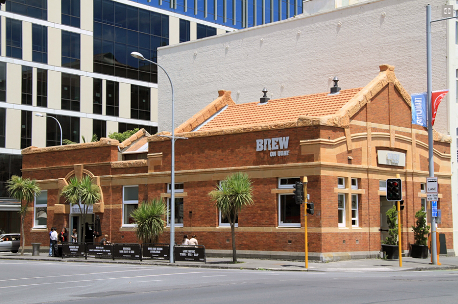
Sign up to hear more
Get the latest heritage news, features and events delivered
straight to your inbox.
