

Dunstan Road was planned and work was underway well before the gold rush to the Dunstan began in August 1862. The road was conceived as one of several routes to the interior of the province, at a time when pastoralism was in its infancy. The road almost certainly followed a general line established by early drays moving between pastoral runs. In common with many other early roads, the Dunstan Road took a high route to avoid the difficulties, in time and cost, in crossing water courses. The first coaches to make the trip from Dunedin to the Dunstan on the road crossed in November 1862. While the route was much quicker than any other at the time, it was often impassable in winter and eventually this led to the decision by coaching companies to abandon the road in favour of low-level but longer options.
The road still had mining traffic but within a few years users were mainly confined to the local and farming-related. The road continued to be used by such traffic in sufficient numbers to warrant its maintenance. This low-level care ensured the road remained open and today, with tourist traffic and an increasing awareness of the road’s significance, the road has had a significant increase in use.
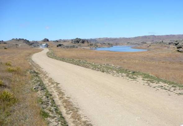
The section of Old Dunstan Road which is registered is a smaller, but still substantial, portion of the original road. It begins in the east at Clarks Junction and ends at Galloway Flat in the Manuherikia Valley. Composed mostly of a metalled road, the registration excludes those parts of the road under tarseal or which have been substantially widened or realigned, with the exception of a portion at the beginning of the registered road. The road is characteristic of the pre-motor vehicle era roads, with generally easy grades for horse-drawn traffic. However, there are steeper sections, which required passengers to alight (when climbing) or for rocks tied to the coach to be slung off the back as brakes when descending. The road moves through a range of landscapes from pasture to tussock and exposed rock, interspersed with lakes and rivers. In characteristic Central Otago fashion there are virtually no trees.
Old Dunstan Road is one of the country’s premier heritage roads, by virtue of its historic importance and association with the very early days of Central Otago gold mining, its rarity as one of the country’s oldest extant roads, and its length, which is far in excess of any other recognised heritage road in the country. It remains a well known and highly regarded historic feature in Central Otago, visited and enjoyed by locals and visitors alike.
List Entry Information
Status
Listed
List Entry Status
Historic Place Category 1
Access
Able to Visit
List Number
7802
Date Entered
15th October 2010
Date of Effect
15th October 2010
City/District Council
Dunedin City,Central Otago District
Region
Otago Region
Extent of List Entry
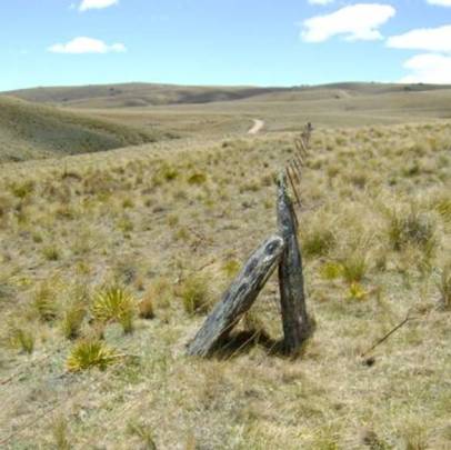
Registration includes the extant portions of the Old Dunstan Road (Road Reserve; Sec 24 SO 301570 (RT 47421) Otago Land District), from the intersection of State Highway 87 and Old Dunstan Road at Clarks Junction, to the intersection with Tiger Hills Road, Galloway Flat, Manuherikia Valley, as marked on the Extent of Registration Map in Appendix 1 of the registration report. The breadth of the item is 20 metres (legal width) from the centre of the road, or the formed road where it varies from the legal road. Registration includes any features within the legal width, road linkages on original alignments, and any historic associated structures (such as bridges, buildings, ruins, culverts, embankments, revetments, fences, ditches, abandoned alignment [immediately adjacent], and signs). Note: Known deviations are shown in Appendix 2 of the registration report; the deviations are still legal road and are included in the registration, except where under water.
Legal description
Road Reserve; Sec 24 SO 301570 (RT 47421), Otago Land District.
Location Description
The road covers a large distance from Clarks Junction, inland from Dunedin, to the Galloway Flat in the Manuherikia Valley, following an approximately north to north-west direction. The full address is Old Dunstan Road, Clarks Junction, Lammermoor Range, Rock and Pillar Range, Paerau (Styx), Linnburn Runs Road, Rough Ridge, Ida Valley, Poolburn, Webster Lane, Raggedy Range, Manuherikia, Galloway Flat, Otago.
Status
Listed
List Entry Status
Historic Place Category 1
Access
Able to Visit
List Number
7802
Date Entered
15th October 2010
Date of Effect
15th October 2010
City/District Council
Dunedin City,Central Otago District
Region
Otago Region
Extent of List Entry
Registration includes the extant portions of the Old Dunstan Road (Road Reserve; Sec 24 SO 301570 (RT 47421) Otago Land District), from the intersection of State Highway 87 and Old Dunstan Road at Clarks Junction, to the intersection with Tiger Hills Road, Galloway Flat, Manuherikia Valley, as marked on the Extent of Registration Map in Appendix 1 of the registration report. The breadth of the item is 20 metres (legal width) from the centre of the road, or the formed road where it varies from the legal road. Registration includes any features within the legal width, road linkages on original alignments, and any historic associated structures (such as bridges, buildings, ruins, culverts, embankments, revetments, fences, ditches, abandoned alignment [immediately adjacent], and signs). Note: Known deviations are shown in Appendix 2 of the registration report; the deviations are still legal road and are included in the registration, except where under water.
Legal description
Road Reserve; Sec 24 SO 301570 (RT 47421), Otago Land District.
Location Description
The road covers a large distance from Clarks Junction, inland from Dunedin, to the Galloway Flat in the Manuherikia Valley, following an approximately north to north-west direction. The full address is Old Dunstan Road, Clarks Junction, Lammermoor Range, Rock and Pillar Range, Paerau (Styx), Linnburn Runs Road, Rough Ridge, Ida Valley, Poolburn, Webster Lane, Raggedy Range, Manuherikia, Galloway Flat, Otago.
Why is this place significant?
Historic Significance
Historical Significance or Value Old Dunstan Road is of special historical significance for the brief period that it spent as the primary route to the Dunstan goldfields from 1862 to 1864. Those early years were the most frenetic and intensive in the history of Central Otago gold mining and set the path for the settlement that followed. Old Dunstan Road played a pivotal part in the early rush by getting miners to and from the goldfields at a time when there was no more direct option. There was sufficient traffic on the Old Dunstan Road to allow a plethora of licensed and unlicensed establishments to spring up on the road. Although its initial period of heavy use was very short-lived the road’s modest use thereafter allowed the road to survive without an upgrade for twentieth century vehicles, the key to its present authentic condition. On the back of a small amount of farming, tourist and commuter traffic, the road has had just enough use to justify its maintenance and therefore its survival. The road is a place of special significance in the colourful history of the settlement of Central Otago. Its relentless construction over four mountain ranges in a direct route to the goldfields demonstrates the dogged determination of the road’s builders and of those who used it. Its construction and use in such a harsh environment is celebrated in the lore of Central Otago and in events such as the annual cavalcade.
Physical Significance
Aesthetic Significance or Value Old Dunstan Road travels through a variety of scenery, much of it strikingly beautiful. The remaining sections of road are still lengthy, so the four mountain ranges and associated valleys offer a diversity of landscapes, vegetation, vistas, and natural and man-made features that collectively are among the most distinctive of any in New Zealand. The road makes its own contribution to this through its role as an unobtrusive but evocative element in the wider landscape. The outstanding aesthetic value has been illustrated in Grahame Sydney’s film 'Dreaming of El Dorado.' Archaeological Significance or Value Old Dunstan Road has significant archaeological values, despite the changes and regular maintenance it has received over its history. Its archaeological values lie firstly in its subsurface structure, which includes the road itself, those features and fragments possibly now buried or partly ruined such as stone culverts and drains, or associated features relating to the road and its past uses (buildings sites, walls, machinery etc.) that are now no longer visible. Secondly there are those archaeological features still visible, including the stone walls and revetting, original or early bench cuts, culverts and drains, and other road features not mentioned above that were part of the original road. Technological Significance or Value Old Dunstan Road occupies a singular place in the pantheon of New Zealand’s historic roads; it contains what are almost certainly the longest unbroken sections of heritage roading in New Zealand. No other nineteenth century road of this length (or longer) still on its original or near original alignment and largely unchanged (bar some minor widening, grading and water tabling) is known to have survived. The road is technologically important in a number of ways. It exhibits the classic attributes of a pre-motor vehicle road in the way it is aligned to form a horse-friendly carriageway. The road also demonstrates a characteristic of many of the country’s surviving nineteenth century roads in that it was built on higher ground to avoid what was thought to be the more difficult obstacles of swampy ground and / or water courses. It contains evidence of old road building techniques, with original or near original bench cuts, cuttings, embankments, stone culverts, revetting etc. The road was built by men using pick and shovel, augmented by explosives, in what was sometimes difficult country.
Why is this place Category 1 / Category 2?
Detail Of Assessed Criteria
(a) The extent to which the place reflects important or representative aspects of New Zealand history Old Dunstan Road reflects both important and representative aspects of this country’s history. Its close association with the discovery and early extraction of gold played a key part in the rapid improvement of the economy both in Otago and nationally. The Dunstan gold field was one of the region’s productive early fields and the road played a key role in moving miners to and from the field, before it was abandoned for less exposed routes. In this the road can also be seen to have played its part in the settlement of Central Otago, in the spread of farming and the rise of tourism. (b) The association of the place with events, persons, or ideas of importance in New Zealand history The road is directly associated with the discovery of gold in the Dunstan, an event of great importance in the history of gold mining in Central Otago, which was in turn responsible for helping propel the New Zealand economy in the nineteenth century and encouraged the opening up and settlement of Central Otago. Some or much of the road’s design is attributed to John Thomson, a significant figure in surveying and engineering not only in Otago but also nationally. Thomson made a huge contribution to the development of the infant colony and Old Dunstan Road is a reminder of his role in provincial road building. (c) The potential of the place to provide knowledge of New Zealand history The road and its environs undoubtedly offer the potential to reveal important information through archaeological methods. The road dates back to the early 1860s and there is much evidence that information on the existing alignment, abandoned portions and the structures alongside it, many of which have disappeared from the landscape, might well be revealed through such an approach. This might in turn shed light on this key aspect of New Zealand history. (d) The community association with, or public esteem for the place As with other old metalled roads in Central Otago, Old Dunstan Road evokes considerable local sentiment, by virtue of its age and authenticity and also for its location in a highly regarded landscape. Old Dunstan Road is recognised nationally for its importance. It has featured in many books, both historical and more recent. It is well known as a destination for tourists, local or overseas, and the road and the scenic landscape it occupies are held in great affection by locals and visitors. People from New Zealand and international travellers respond to the road’s appeal by driving it in their thousands and, while some find it uncomfortably dangerous, most (judging by comments posted on the internet) find it exhilarating and beguiling. The evidence for the road’s status can partly be found in the community response to the Project Hayes wind farm, which saw the proposed scheme as a major threat to the road as well as the landscape. (e) The potential of the place for public education The road and its environs have great potential for public education. While guided tours currently offer some interpretation, the possibilities thus far have barely been explored. The road itself can convey something of its origins and past uses but the sheer length of the road and its long history offer endless opportunities for interpretation, which would in turn help unlock the road’s potential for visitors. (f) The technical accomplishment or value, or design of the place For most of its length the road is a basic one-lane unsealed road. Ostensibly, the road is without any major technical achievement; it sticks to ridges, did not require a major intervention (such as big cuttings) or significant engineering achievement to allow its construction and it may not have been formed or metalled in some places when it was first constructed. However, the road was built by hand in a challenging environment using nineteenth century tools and technology. It is likely that on the ridge tops the removal of very large tussock plants would have presented a considerable obstacle to overcome. Some of the sections, lengthy and at a relatively high altitude, have no parallel in the country’s remaining nineteenth century roads, with the possible exception of the Skippers Canyon Road, most of which is at a considerably lower altitude but traverses more difficult country. One specific section of the road, at its north-west end, contains fine examples of stone revetting, culverts and embankments that are not matched anywhere else on the road. (i) The importance of identifying historic places known to date from early periods of New Zealand settlement Old Dunstan Road is one of New Zealand’s earliest examples of a relatively unmodified nineteenth century road. Of New Zealand’s stock of recognised heritage roads, only Old Coach Road in Johnsonville is older than Old Dunstan Road, which makes the latter a remarkable survivor from within the first 15 years of the founding of Dunedin. (j) The importance of identifying rare types of historic places The rarity of Old Dunstan Road is manifest. New Zealand’s stock of recognised heritage roads is a small one. Those that are registered are: Old Coach Road, Johnsonville (1856-58, Category I), Skippers Canyon Road, Central Otago (1883-1890, Category I), Ohakune-Horopito Old Coach Road (1904-06, Category I) and Waoku Coach Road, South Hokianga (1889-1891, Category I). There are other roads of some antiquity in Central Otago that have not yet been assessed for heritage value. However, they are small in number and do not diminish the rarity of what is the most complete of any old Otago road. The survival of any public work built by a provincial government is also rare and this is one of those rare examples from Otago. (k) The extent to which the place forms part of a wider historical and cultural complex or historical and cultural landscape Gold mining was one of the most significant activities in the history of Otago and it left its mark all over the province and in a plethora of remarkable ways. Old Dunstan Road plays its part in that collection of historic relics by demonstrating how miners got to and from the goldfields, the hardships they endured in getting there and the nature of nineteenth century roads. There are few of those gold mining-related structures still in use. On a local level, various parts of Old Dunstan Road form part of smaller landscapes and it has played its part in the history of those places (such as the the use of Old Dunstan Road to build Poolburn Dam in the Deep Creek to Paerau section of the road). Conclusion It is considered that this place qualifies as a Category I historic place. Old Dunstan Road is a place of outstanding significance. One of the country’s longest and oldest heritage roads, it remains in a substantially original state nearly 150 years after its construction. It has particular significance for its role in the early opening up of the interior for gold mining, for its continuous use since its construction, and for the dramatic and beautiful setting the road passes through. It is a familiar and much appreciated feature of the Central Otago landscape.
Construction Professional
Name
Thomson, John Turnbull
Type
Architect
Biography
John Turnbull Thomson (1821- 1884) was born in Northumberland, England and educated in Berwickshire, Scotland. He studied mathematics at Aberdeen University and engineering at Newcastle before travelling to South-east Asia to work in the jungles of Penang, Malaysia. He was only 20 when he was appointed government surveyor by the governor of Singapore. He drew maps and constructed bridges, buildings and roads. After 12 years of work he was invalided back to England in 1853 and after his recovery he moved to New Zealand. His work in Singapore led, upon his arrival in 1856, to an immediate offer of the position of chief surveyor of Otago. He took up the job in May 1856 and his first big project was laying out the proposed town of Invercargill. In 1857-58 he surveyed Otago province, a huge undertaking that had to be done on horseback. In addition to his surveying work he designed bridges and roads across the province. To facilitate the expansion of Dunedin he supervised the removal of Bell Hill. Thomson married Jane Williamson on 7 October 1858 and he and his wife had nine daughters in all. As a mark of Thomson's standing, he was appointed the country’s first surveyor general after the dissolution of the provinces and the establishment of the Survey Department in 1876. He retired on 31 October 1879. Even in retirement he and his wife had another daughter - their ninth and last. Thomson was a skilled and prolific watercolourist and author. He and his family retired to Invercargill and the house he had built, Lennel, is registered Category I by the NZHPT. (Michael Kelly and Ray Stone, Old Dunstan Road Registration Report, 17 September 2010, NZHPT)
Construction Details
Type
Modification
Description
The portion from Dunedin to Clarks Junction is subsumed into State Highway 87 and later sealed (or vice versa).
Period
Unknown
Type
Modification
Description
Original portion of road in Upper Taieri Valley from Styx to bottom of Rough Ridge bypassed.
Period
Unknown
Start Year
1931
Finish Year
1931
Type
Modification
Description
Poolburn Dam built and Old Dunstan Road rerouted after part of the road is flooded.
Type
Modification
Description
Creation of the Paerau Reservoir floods part of road in and around Paerau (Styx).
Period
Unknown
Start Year
1984
Type
Other
Description
Loganburn Reservoir formed adjacent to Old Dunstan Road on Rock and Pillar Range.
Start Year
1849
Type
Other
Description
Road from Dunedin central to Saddle Hill built by New Zealand Company (now State Highway1).
Start Year
1855
Type
Other
Description
First pastoralists move into Otago’s hinterland, establishing transport routes.
Start Year
1857
Type
Other
Description
Shennan brothers establish run in Manuherikia Valley, using drays to carry their goods. Parts of the track they form are later used in Dunstan Road.
Start Year
1861
Type
Original Construction
Description
Work begins on construction of Dunstan Road.
Start Year
1862
Type
Original Construction
Description
Section from Saddle Hill to Silverstream completed.
Start Year
1862
Type
Original Construction
Description
Section from Silverstream to West Taieri completed. First drays arrive at Dunstan via Dunstan Road.
Start Year
1862
Type
Original Construction
Description
Contracts let to widen and form road (improve the road for horses) north of West Taieri Ferry.
Start Year
1862
Type
Modification
Description
Rerouting the road north from the Styx to Linnburn Station. From Ida Valley the road was rerouted in a more north-westerly direction towards Galloway. The original route is still extant, on private land.
Start Year
1864
Type
Other
Description
Major work on the road continues through 1864.
Construction Materials
Metal (crushed rock), asphalt, stone revetting and culverts.
Maori Occupation and Routes Maori were well aware of the resources of Central Otago, with large moa butchering sites recorded, as well as settlement sites related to food and other resource gathering known in many locations, including sites on the Maniototo Plains and at the Serpentine where eel traps were found. There was seasonal weka hunting on the Rock and Pillar Range, and there are a number of rock shelters and possible Moa butchery sites in the vicinity of Deep Stream. Maori from Otago Peninsula and Henley (Mataipapa) were known to go birding in the Maniototo. Routes to inland Otago were known and generally followed the course of the main rivers: in the south the Mataura, centrally the Mataau (Clutha River) and in the north the Waitaki River. Accessing the Interior: Early Pastoralism Roading and communications was an important issue for the fledgling settlements in Otago, and with few settlers and a huge expanse of land, a considerable burden for the impoverished province. One commentator reported in May 1858 that the southern approach to Dunedin had been metalled but that the work was incomplete, and ‘[p]erfect road-making is yet beyond our means.’ John Turnbull Thomson on return from his first foray into the interior suggested that a ‘pioneer corps of road-makers would do much to assist the first settlers in opening the country and in developing that highly valuable branch of colonial industry, viz.. the pastoral interest. It is scarcely fair to the one or two enterprising energetic individuals that open a new country to have the burden of forming the roads for others to reap the advantage thereof, while at the same time the property that they invest in so direct and rapid a manner tends to advance the population of the Province in their progress to wealth and prosperity.’ The pastoralism of the late 1850s required the development of routes to the isolated stations, particularly to allow the transport of wool to the coastal transport networks. Turnbull Thomson identified the significance of routes as ‘useful information to intending Stockowners’ wanting to access the ‘natural Pasture’ which extended over 15,000 square miles (9,600,000 acres). The main routes Thomson identified (in order of ease of access) were Oamaru and up the Waitaki Valley which would be relatively accessible by dray, Waikouaiti then by up the Waihemo valley which a dray could follow with ‘some difficulty’ to the Upper Taieri, and then relatively easily to the Manuherikia and the Upper Clutha, the Port of Otago ‘drays can only be taken to the valleys south-west of the same, adjacent to the sea board,’ the Molyneux, and New River by way of the Upper Mataura and Jacob’s River. Thomson drew international parallels to emphasise the importance of transport in the development of Otago, emphasising unity: ‘easy communication, especially by land, binds separate, and what would otherwise be antagonistic, communities into one.’ A route into the interior, Thomson argued, would mean that ‘[l]ivehold of the money expended would come to the public revenue by the sales of waste lands, and tenfold would accrue to the private settlers in the increased marketable value of their properties; whilst Dunedin, the focus of all, would advance with all.’ By 1858 there was money set aside for roading. A report in the Otago Witness in October of that year noted that £5,000 had been set aside for the construction of the ‘Shag Valley Road to the Interior’, and £500 for roading in the vicinity of West Taieri. Accounts of just how these roads were formed are contradictory and confusing. At first the routes to Central Otago were simply the work of runholders forming tracks through their land. Historian James Herries Beattie described the experiences of Watson Shennan, who took up the Moutere and Galloway runs in the Manuherikia Valley run with his brother Alexander. Shennan recounted ‘I do not think it possible to experience greater hardship and live – with drifts of snow from 4 feet to 30 feet deep. My party had nothing hot to eat or drink for three days, and the bullocks were not out of the yokes for the same time, and had hardly any food. When I picked the party up with the sheep in Ida Valley they were out of provisions and had only mutton to eat for some days and had lost a man and a horse….The horses had to be moved from one big snow tussock to another, that being the only food they could get. The party could only find enough sticks to boil the billy and cook a chop, not sufficient for a fire to warm them. A journey to the South Pole is nothing to a trip like that.’ More than one account states that the Otago Provincial Council funded or part-funded the formation of dray roads. In 1858, the Provincial Council voted £1000 to construct three roads, but by June the following year, none of it had been spent. It is more than likely that the road from West Taieri to Interior was in fact started not as a formed road but as a track made by repeated use by drays. The provincial government was merely enhancing something that already existed. By the end of 1860 the road to the interior via the Taieri was further developed and became associated with the development as Dunedin as the Provincial capital. The Provincial superintendent, James Macandrew, asked that the Provincial Council sanction the ‘construction of a main line of road from Dunedin into the interior of the Province, by way of the Upper Taieri Ferry [today’s Outram]’. Macandrew went on: ‘I have no hesitation in saying that, as a main line, that now leaves all other main lines throughout the Province entirely in the shade. It is a road which will directly affect a greater variety of interests – a greater amount of available country, and tend more to consolidate the Province than any other. The effect of this line will be to present an outlet for more agricultural, pastoral, and dairy produce, than can be presented by any other road line in New Zealand. It will ultimately connect Dunedin, by the best and shortest route, with the whole southern country as far as the banks of the Waiau, the Upper New River Plains, the Upper Clutha, the Manuherikia, Lammermoor, Shag Valley, and, I have no doubt, the greater portion of the interior, now supposed to be accessible only from Oamaru, Moeraki and Waikouaiti.’ Macandrew was clear about the benefits the route’s proximity to Dunedin, and linked it to the opening of the Panama Canal and, rather presciently, the effect of the Victorian gold rushes (without the drawbacks!) in Australia. The road would secure Dunedin in it position as the centre for Otago, and will make Dunedin ‘the natural outlet for the produce of upwards of seven millions of acres of the finest agricultural and pastoral country in the Province.’ He waxed lyrical ‘There is a tide in the affairs of men, when taken at the flood, leads on to fortune;” the same rule applies to communities, and it only rests with out to say the word, to utter the ‘open sesame,’ which will put the hitherto insignificant Province of Otago into the proudest position of any of the numerous colonies of Great Britain in this Hemisphere.’ Runholders joined the chorus. At a meeting at West Taieri there was a call for the immediate construction of a ‘passable road from Harvey’s Flat to the Deep Stream at Mr Walker’s crossing.’ The meeting proposed that the interested runholders be ‘assessed in proportion to the stock on their respective runs, to the amount required for making the road.’ Messrs Valpy, Thomson and Walker were requested to superintend the making of the road. Mr Lee, who also attended went further, stating it was necessary ‘at once to take steps for securing and making the main road leading from the Upper Taieri Ferry into the interior districts, as well as any other sideline from the plain at Maungaatua Bush in the same direction.’ The attendees hoped that the Government, observing the ‘numerous attendance’ would see the necessity of laying off the line so that the runholders ‘may have every facility for a direct communication with Dunedin before the wool season.’ That there were local interests involved in the campaigning for the variety of routes was an issue that the Provincial Government had to pick a wary trail through: ‘Local influences are ever at work to the prejudice of the general interests.’ Survey and proper planning were essential. The superintendent stated that no road should have money expended on it until, in the case of dray tracks, a reconnaissance survey had been undertaken, and in the cue of permanent roads until the line had been finally decided on, the levels taken, and the approximate expense per mile ascertained, and then after these preliminary necessaries had been fulfilled the portions of the road intended for formation advertised for contract.’ Settlers who ventured onto the hilltops to the west of the Taieri River would observe the ‘operations of working parties engaged in blasting the solid rock in order to force a way to the Upper Clutha Valley, a distance of 150 miles, and learns that even a dray track might probably cost about £15,000.’ E.M. Lovell-Smith, writing in 1931, describes work on the dray road, from West Taieri to Black’s station at the Manuherikia (now Ophir), beginning in April 1860 and being completed a year later. The Otago Provincial Council was clearly planning a major road through the middle of the province by 1860. The Superintendent outlined the Council’s intentions at the opening of the Eleventh Session in December that year: ‘Another public work to which your sanction will be requested will be the construction of a main line of road from Dunedin into the interior of the Province, by way of the Upper Taieri Ferry, which it is proposed to bridge... It is a road which will directly affect a greater variety of interests - a greater amount of available country, and tend more to consolidate the Province than any other...It will ultimately connect Dunedin, by the best and shortest route, with the whole southern country as far as the banks of the Waiau, the Upper New River Plains, the Upper Clutha, the Manuherikia, Lammermoor, Shag Valley, and, I have no doubt, the Lake Country, and the greater portion of the interior, now supposed to be accessible only from Oamaru, Moeraki, and Waikouaiti.’ The route chosen was to be by some distance the shortest to Central Otago. It followed a fairly direct line from west of Dunedin to the Dunstan, a distance of 170 kilometres. It traversed four mountain ranges; the Lammermoors, the Rock and Pillars, Rough Ridge and the Raggedy Ranges. The first appropriation for the road was made in January 1861, when £2000 was set aside for the ‘West Taieri to Interior’ road. There were arguments in the provincial assembly about the allocation of funding for roads to the interior with some members calling for just one road rather than several. John Hall-Jones attributes the design of the road’s surveyed route to J.T. Thomson, then Chief Surveyor and Chief Engineer for the province. However, Hall-Jones suggests that the decision on what route to take was made in haste by Thomson after the Dunstan goldfield was opened up. As there were vehicles on the road within weeks of the discovery of gold it seems more likely that the road was designed much earlier and work was proceeding in a measured fashion. The urgent work would seem to have been needed once the rudimentary road was required for the use of the miners. The section from the town centre to Saddle Hill had apparently already been built, by the New Zealand Company, in 1849. Tenders were called in 1861 for the construction of the next section, to Silverstream (near Mosgiel, now State Highway 87), but progress was slow. By early 1862 the section from Saddle Hill to Silverstream was completed and the going to West Taieri must have been better because that was completed by September that year. However, just to confuse matters, the Superintendent made the following comments in a speech to the Provincial Council on 19 June 1861. ‘Heavy as the expenditure has been between Dunedin and the Taieri, amounting to not less than £1600 a mile of actual outlay, the country settler as he rides into town at once recognises the necessity of the work; but when he crosses the Taieri plain, ascends the hills on the other side of the river, and witnesses the operations of the working parties engaged in blasting the solid rock in order to force a way to the Upper Clutha Valley, a distance of 150 miles, one learns that even a dray track might probably cost about £15,000, he asks himself why the present communication with the interior which is now traversed by drays, could not be improved at a comparatively trifling expense.’ The gold rushes The story of nineteenth century Otago is highlighted by the extraordinary burst of prosperity that occurred after the discovery of gold in the hinterland. In the space of a few years from 1862 it turned Dunedin from a small southern town into the colony’s richest city and established its status for the remainder of the century. The movement of people and goods to and from the richest goldfields became a matter of the highest priority. Roads became the means to connect the coast with the hinterland and the most famous but most briefly used
Maori Occupation and Routes Maori were well aware of the resources of Central Otago, with large moa butchering sites recorded, as well as settlement sites related to food and other resource gathering known in many locations, including sites on the Maniototo Plains and at the Serpentine where eel traps were found. There was seasonal weka hunting on the Rock and Pillar Range, and there are a number of rock shelters and possible Moa butchery sites in the vicinity of Deep Stream. Maori from Otago Peninsula and Henley (Mataipapa) were known to go birding in the Maniototo. Routes to inland Otago were known and generally followed the course of the main rivers: in the south the Mataura, centrally the Mataau (Clutha River) and in the north the Waitaki River. Accessing the Interior: Early Pastoralism Roading and communications was an important issue for the fledgling settlements in Otago, and with few settlers and a huge expanse of land, a considerable burden for the impoverished province. One commentator reported in May 1858 that the southern approach to Dunedin had been metalled but that the work was incomplete, and ‘[p]erfect road-making is yet beyond our means.’ John Turnbull Thomson on return from his first foray into the interior suggested that a ‘pioneer corps of road-makers would do much to assist the first settlers in opening the country and in developing that highly valuable branch of colonial industry, viz.. the pastoral interest. It is scarcely fair to the one or two enterprising energetic individuals that open a new country to have the burden of forming the roads for others to reap the advantage thereof, while at the same time the property that they invest in so direct and rapid a manner tends to advance the population of the Province in their progress to wealth and prosperity.’ The pastoralism of the late 1850s required the development of routes to the isolated stations, particularly to allow the transport of wool to the coastal transport networks. Turnbull Thomson identified the significance of routes as ‘useful information to intending Stockowners’ wanting to access the ‘natural Pasture’ which extended over 15,000 square miles (9,600,000 acres). The main routes Thomson identified (in order of ease of access) were Oamaru and up the Waitaki Valley which would be relatively accessible by dray, Waikouaiti then by up the Waihemo valley which a dray could follow with ‘some difficulty’ to the Upper Taieri, and then relatively easily to the Manuherikia and the Upper Clutha, the Port of Otago ‘drays can only be taken to the valleys south-west of the same, adjacent to the sea board,’ the Molyneux, and New River by way of the Upper Mataura and Jacob’s River. Thomson drew international parallels to emphasise the importance of transport in the development of Otago, emphasising unity: ‘easy communication, especially by land, binds separate, and what would otherwise be antagonistic, communities into one.’ A route into the interior, Thomson argued, would mean that ‘[l]ivehold of the money expended would come to the public revenue by the sales of waste lands, and tenfold would accrue to the private settlers in the increased marketable value of their properties; whilst Dunedin, the focus of all, would advance with all.’ By 1858 there was money set aside for roading. A report in the Otago Witness in October of that year noted that £5,000 had been set aside for the construction of the ‘Shag Valley Road to the Interior’, and £500 for roading in the vicinity of West Taieri. Accounts of just how these roads were formed are contradictory and confusing. At first the routes to Central Otago were simply the work of runholders forming tracks through their land. Historian James Herries Beattie described the experiences of Watson Shennan, who took up the Moutere and Galloway runs in the Manuherikia Valley run with his brother Alexander. Shennan recounted ‘I do not think it possible to experience greater hardship and live – with drifts of snow from 4 feet to 30 feet deep. My party had nothing hot to eat or drink for three days, and the bullocks were not out of the yokes for the same time, and had hardly any food. When I picked the party up with the sheep in Ida Valley they were out of provisions and had only mutton to eat for some days and had lost a man and a horse….The horses had to be moved from one big snow tussock to another, that being the only food they could get. The party could only find enough sticks to boil the billy and cook a chop, not sufficient for a fire to warm them. A journey to the South Pole is nothing to a trip like that.’ More than one account states that the Otago Provincial Council funded or part-funded the formation of dray roads. In 1858, the Provincial Council voted £1000 to construct three roads, but by June the following year, none of it had been spent. It is more than likely that the road from West Taieri to Interior was in fact started not as a formed road but as a track made by repeated use by drays. The provincial government was merely enhancing something that already existed. By the end of 1860 the road to the interior via the Taieri was further developed and became associated with the development as Dunedin as the Provincial capital. The Provincial superintendent, James Macandrew, asked that the Provincial Council sanction the ‘construction of a main line of road from Dunedin into the interior of the Province, by way of the Upper Taieri Ferry [today’s Outram]’. Macandrew went on: ‘I have no hesitation in saying that, as a main line, that now leaves all other main lines throughout the Province entirely in the shade. It is a road which will directly affect a greater variety of interests – a greater amount of available country, and tend more to consolidate the Province than any other. The effect of this line will be to present an outlet for more agricultural, pastoral, and dairy produce, than can be presented by any other road line in New Zealand. It will ultimately connect Dunedin, by the best and shortest route, with the whole southern country as far as the banks of the Waiau, the Upper New River Plains, the Upper Clutha, the Manuherikia, Lammermoor, Shag Valley, and, I have no doubt, the greater portion of the interior, now supposed to be accessible only from Oamaru, Moeraki and Waikouaiti.’ Macandrew was clear about the benefits the route’s proximity to Dunedin, and linked it to the opening of the Panama Canal and, rather presciently, the effect of the Victorian gold rushes (without the drawbacks!) in Australia. The road would secure Dunedin in it position as the centre for Otago, and will make Dunedin ‘the natural outlet for the produce of upwards of seven millions of acres of the finest agricultural and pastoral country in the Province.’ He waxed lyrical ‘There is a tide in the affairs of men, when taken at the flood, leads on to fortune;” the same rule applies to communities, and it only rests with out to say the word, to utter the ‘open sesame,’ which will put the hitherto insignificant Province of Otago into the proudest position of any of the numerous colonies of Great Britain in this Hemisphere.’ Runholders joined the chorus. At a meeting at West Taieri there was a call for the immediate construction of a ‘passable road from Harvey’s Flat to the Deep Stream at Mr Walker’s crossing.’ The meeting proposed that the interested runholders be ‘assessed in proportion to the stock on their respective runs, to the amount required for making the road.’ Messrs Valpy, Thomson and Walker were requested to superintend the making of the road. Mr Lee, who also attended went further, stating it was necessary ‘at once to take steps for securing and making the main road leading from the Upper Taieri Ferry into the interior districts, as well as any other sideline from the plain at Maungaatua Bush in the same direction.’ The attendees hoped that the Government, observing the ‘numerous attendance’ would see the necessity of laying off the line so that the runholders ‘may have every facility for a direct communication with Dunedin before the wool season.’ That there were local interests involved in the campaigning for the variety of routes was an issue that the Provincial Government had to pick a wary trail through: ‘Local influences are ever at work to the prejudice of the general interests.’ Survey and proper planning were essential. The superintendent stated that no road should have money expended on it until, in the case of dray tracks, a reconnaissance survey had been undertaken, and in the cue of permanent roads until the line had been finally decided on, the levels taken, and the approximate expense per mile ascertained, and then after these preliminary necessaries had been fulfilled the portions of the road intended for formation advertised for contract.’ Settlers who ventured onto the hilltops to the west of the Taieri River would observe the ‘operations of working parties engaged in blasting the solid rock in order to force a way to the Upper Clutha Valley, a distance of 150 miles, and learns that even a dray track might probably cost about £15,000.’ E.M. Lovell-Smith, writing in 1931, describes work on the dray road, from West Taieri to Black’s station at the Manuherikia (now Ophir), beginning in April 1860 and being completed a year later. The Otago Provincial Council was clearly planning a major road through the middle of the province by 1860. The Superintendent outlined the Council’s intentions at the opening of the Eleventh Session in December that year: ‘Another public work to which your sanction will be requested will be the construction of a main line of road from Dunedin into the interior of the Province, by way of the Upper Taieri Ferry, which it is proposed to bridge... It is a road which will directly affect a greater variety of interests - a greater amount of available country, and tend more to consolidate the Province than any other...It will ultimately connect Dunedin, by the best and shortest route, with the whole southern country as far as the banks of the Waiau, the Upper New River Plains, the Upper Clutha, the Manuherikia, Lammermoor, Shag Valley, and, I have no doubt, the Lake Country, and the greater portion of the interior, now supposed to be accessible only from Oamaru, Moeraki, and Waikouaiti.’ The route chosen was to be by some distance the shortest to Central Otago. It followed a fairly direct line from west of Dunedin to the Dunstan, a distance of 170 kilometres. It traversed four mountain ranges; the Lammermoors, the Rock and Pillars, Rough Ridge and the Raggedy Ranges. The first appropriation for the road was made in January 1861, when £2000 was set aside for the ‘West Taieri to Interior’ road. There were arguments in the provincial assembly about the allocation of funding for roads to the interior with some members calling for just one road rather than several. John Hall-Jones attributes the design of the road’s surveyed route to J.T. Thomson, then Chief Surveyor and Chief Engineer for the province. However, Hall-Jones suggests that the decision on what route to take was made in haste by Thomson after the Dunstan goldfield was opened up. As there were vehicles on the road within weeks of the discovery of gold it seems more likely that the road was designed much earlier and work was proceeding in a measured fashion. The urgent work would seem to have been needed once the rudimentary road was required for the use of the miners. The section from the town centre to Saddle Hill had apparently already been built, by the New Zealand Company, in 1849. Tenders were called in 1861 for the construction of the next section, to Silverstream (near Mosgiel, now State Highway 87), but progress was slow. By early 1862 the section from Saddle Hill to Silverstream was completed and the going to West Taieri must have been better because that was completed by September that year. However, just to confuse matters, the Superintendent made the following comments in a speech to the Provincial Council on 19 June 1861. ‘Heavy as the expenditure has been between Dunedin and the Taieri, amounting to not less than £1600 a mile of actual outlay, the country settler as he rides into town at once recognises the necessity of the work; but when he crosses the Taieri plain, ascends the hills on the other side of the river, and witnesses the operations of the working parties engaged in blasting the solid rock in order to force a way to the Upper Clutha Valley, a distance of 150 miles, one learns that even a dray track might probably cost about £15,000, he asks himself why the present communication with the interior which is now traversed by drays, could not be improved at a comparatively trifling expense.’ The gold rushes The story of nineteenth century Otago is highlighted by the extraordinary burst of prosperity that occurred after the discovery of gold in the hinterland. In the space of a few years from 1862 it turned Dunedin from a small southern town into the colony’s richest city and established its status for the remainder of the century. The movement of people and goods to and from the richest goldfields became a matter of the highest priority. Roads became the means to connect the coast with the hinterland and the most famous but most briefly used
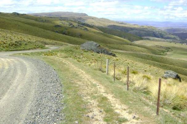
Route The Old Dunstan Road can be divided in many ways but for the purposes of this report, seven sections are delineated, of which five are included in the registration. These sections are divided by geographical distinctions: generally the conclusion of mountainous sections, by turnoffs, or by changes of road type. The road is described as if one is travelling from Dunedin to Alexandra, the direction taken by the miners travelling to the goldfields. Section 1: Dunedin to West Taieri (Outram). This section is largely under tarseal and does not closely resemble its original form. However, some sections closely follow the original alignment while there are certainly sections of the original road on private land and these can be followed for short distances. [Note: This section is not included in the registration]. Section 2: West Taieri to Clarks Junction This portion, which generally follows the original alignment, is also under tarseal. The main departures from the original route are on the hills immediately north and west of Outram, where the original bench cuts and sidles have been replaced by a more direct and steeper route. Glimpses of the original road can still be seen in the hills on either side of the road. [Note: This section is not included in the registration]. Section 3: Clarks Junction to Deep Stream (Rocklands Station) This part of the road is a relatively short section, which is delineated out because, although it is the start of the proposed registered road, it is sealed. The sealed road is little altered from the original in many respects. It is relatively narrow and is set on a horse-friendly gradient that rises slowly on an undulating landscape to Deep Stream, very close to Rocklands Station, sitting at a little less than 400m in altitude. Just before Deep Stream, the sealed road bypasses an earlier short section of road. It should also be noted that this part of the road is also included in the registration because it signals the start of that part of the Old Dunstan Road that has not been subsumed into regional highways. Section 4: Deep Stream to Paerau (Styx) The road, unsealed and metalled, rises from Deep Stream quite steeply over the Lammermoor Range towards the eastern side of the Rock and Pillar Range. The terrain flattens out as the surrounding farmland changes from pasture to tussock grassland. Another steep climb takes the road over the eastern portion of the Rock and Pillar Range and past the Loganburn Reservoir, once the ‘Great Moss Swamp’ before a dam was constructed for the Maniototo Irrigation Company in 1984. The highest point on the Rock and Pillars (1041 metres) is reached just after the reservoir, at which point there is a turnoff to McPhee's Rock, named after Mother McPhee, who ran an accommodation house that served the coaches during the 1860s. Along the way, four-wheeled tracks lead from the main road to other destinations, such as the Te Papanui Conservation Area. The descent to the Paerau (or Styx) is a relatively steep one, denoted as 1 in 10 on one map. Approximately half way down, a bypassed portion of the road, presumably built to maintain the grade for horses, extends into a gully and out again. At the bottom, at an elevation of approximately 600m, is the original Styx Hotel, along with lock-up built for the police and the hotel stables. Section 5: Paerau (Styx) to intersection with Linnburn Runs Road The Old Dunstan Road turns east as it reaches the Upper Taieri-Paerau Road and fords Styx Creek. The road passes the historic buildings at Styx and then fords the Taieri River. It is then lost on the margins of the Paerau Reservoir. The road re-emerges a little further north, on the western side of the reservoir and rejoins the Patearoa-Paerau Road. A short distance after this the Old Dunstan Road leaves in a north-westerly direction across private land. Cadastral maps show that the Old Dunstan Road is still legally defined from here to where it meets the Linnburn Runs Road at the bottom of Rough Ridge. Some maps mark only part of the road as intact but this portion has been viewed in part by one of the authors and in total by the other. The road leaves Paerau and climbs very gently in a north-westerly direction. The road is grassed and not used by vehicles any more but it is reasonably well defined. There is a steeper climb up to a ridge overlooking the Linn Burn and an even steeper descent to the Linn Burn and the Linnburn Runs Road. The road here shows evidence of ruts in the bare rock caused by coaches braking downhill. The probable site of the Blackball Hotel is passed during this section. Section 6: Intersection of Old Dunstan Road / Linnburn Runs Road to Idavale The two ends of the Old Dunstan Road are joined by a short portion of Linnburn Runs Road travelling north. The road then rises immediately from a gate, again in a north-westerly direction across private property, and continues to the top of Rough Ridge. There are long sweeping curves to maintain the grade up the side of the mountain. The going is easier on the top where the road crosses undulating country. However, shortly before the Poolburn Reservoir, the ford of Totara Pinch is crossed. Even to this day it is a difficult, albeit short, descent and climb and it would have been more so for horse-drawn vehicles. At Poolburn Dam the road was rerouted slightly north just before the dam flooded the valley. The road beneath the reservoir is still shown on cadastral maps, as is the detour. At its highest point on Rough Ridge the road reaches just over 1000 metres. The road down to Moa Creek in the Ida Valley has a relatively easy gradient and is frequently used by crib owners and fishermen. At the valley floor the road intersects with Small Road and turns in a westerly direction up Websters Lane to Idavale, a homestead and station on the Moa Creek-Poolburn Road. Websters Lane is a straight road, and therefore not characteristic of an 1860s road. Its role in the alignment of Old Dunstan Road is not entirely clear but it is likely that a subdivision (see SO 1728 [1876]) realigned (straightened) an existing alignment. Section 7: Moa Creek to Galloway From the intersection of Websters Road and Moa Creek-Poolburn Road the road turns south briefly then heads west-north-west across private farmland for the rest of its journey (but remains legal road). For approximately two and a half kilometres the going is flat but the road then climbs in a windy fashion up Rough Ridge via a gully (rather than a ridge). At the top, the going is relatively easy but the road is very poorly defined as it begins a long and easy descent. It becomes much more obvious as a farm track as it continues in its westerly direction down to the intersection with Tiger Hill Road, a few kilometres north of Galloway. The registered road ends here, but for miners heading to The Dunstan (Clyde) it would have meant two river crossings and a trip across the rolling country of the lower south eastern foothills of the Dunstan Mountains. Characteristics of the road Old Dunstan Road is composed of a variety of road forms. The most common is the unsealed, metal road. It is likely to be, on the whole, wider than it was originally. Although the legal width of New Zealand’s narrowest roads was one chain (22 yards or approximately 20 metres), the formation itself was generally very narrow: perhaps four metres or less. Today, while many sections remain narrow, other parts of the road are six metres or more in width, probably the work of a large machine, like a grader. Another change is the level of the road. In places, again perhaps because of the use of machinery, the level of the road is clearly lower than it was. This is illustrated by Figure 32, which shows where a benched portion of the road (now bypassed) would have left the old road. There are references in early Otago newspapers to efforts to ‘macadamise’ the province’s first roads where it was possible. To ‘macadamise’ a road refers to the principles of the famous road engineer John Loudon McAdam (1756-1836), a Scottish engineer and road-builder. He invented a new process, ‘macadamisation’, for building roads with a smooth hard surface that would be more durable and less muddy than soil-based tracks. He used crushed stone bound with gravel on a base of large stones. His roads had a slight camber to ensure that rainwater drained off rather than into the road. Among later improvements to this was the use of tar to bind the road surface together, hence the term ‘tarmac’ for tar macadam. Only some of the Old Dunstan Road was treated in this fashion and what portions still remain are not known. It is likely that this kind of work was of more value on the flat sections closer to Dunedin where the ground conditions were soft. In the mountains macadamising was not employed; the ground cover was simply removed and a route established through the tussock and tors. Some parts of the road (on private property) are barely used by vehicles (if at all) and these are covered by, in most places, grasses or tussock or are bare ground. Metal is only applied to those sections that are in regular use. At the eastern end of the road between Clarks Junction and Deep Creek, the road is sealed, although the road here is only a little wider than the rest of the route. On valley floors and on the primary ridges of the various ranges the road crosses the going is relatively easy. The climbs (and descents) are characteristic of horse-era roads, with the road winding across the mountain sides to maintain a grade suitable for horses. The actual road does drift from the legal road in places, which can be attributed to the following reasons: The surveyed route was based on the tracks made by earlier usage (run holders etc), but that surveyed route was probably never actually “built” as such but more likely was just eased or very lightly benched where and when required. Miners on foot, horses, wagons, coaches etc probably tended to use the easiest way, sometimes because of weather conditions on the day, but more commonly they tended to ‘meander’ along the easiest gradients that were clear of rock outcrops, wet patches etc. (all the while keeping generally to the track/route). The variations occur more commonly on the tops where the open, relatively flat plateau-type country lightly strewn with rock outcrops, make such meandering more likely. There were no boundaries, visible or otherwise, for much of the time so, unlike today, road users were able to meander as and when. The maps in use today are not entirely accurate so there is some doubt as to the amount of variation between the legal and formed roads.
Route The Old Dunstan Road can be divided in many ways but for the purposes of this report, seven sections are delineated, of which five are included in the registration. These sections are divided by geographical distinctions: generally the conclusion of mountainous sections, by turnoffs, or by changes of road type. The road is described as if one is travelling from Dunedin to Alexandra, the direction taken by the miners travelling to the goldfields. Section 1: Dunedin to West Taieri (Outram). This section is largely under tarseal and does not closely resemble its original form. However, some sections closely follow the original alignment while there are certainly sections of the original road on private land and these can be followed for short distances. [Note: This section is not included in the registration]. Section 2: West Taieri to Clarks Junction This portion, which generally follows the original alignment, is also under tarseal. The main departures from the original route are on the hills immediately north and west of Outram, where the original bench cuts and sidles have been replaced by a more direct and steeper route. Glimpses of the original road can still be seen in the hills on either side of the road. [Note: This section is not included in the registration]. Section 3: Clarks Junction to Deep Stream (Rocklands Station) This part of the road is a relatively short section, which is delineated out because, although it is the start of the proposed registered road, it is sealed. The sealed road is little altered from the original in many respects. It is relatively narrow and is set on a horse-friendly gradient that rises slowly on an undulating landscape to Deep Stream, very close to Rocklands Station, sitting at a little less than 400m in altitude. Just before Deep Stream, the sealed road bypasses an earlier short section of road. It should also be noted that this part of the road is also included in the registration because it signals the start of that part of the Old Dunstan Road that has not been subsumed into regional highways. Section 4: Deep Stream to Paerau (Styx) The road, unsealed and metalled, rises from Deep Stream quite steeply over the Lammermoor Range towards the eastern side of the Rock and Pillar Range. The terrain flattens out as the surrounding farmland changes from pasture to tussock grassland. Another steep climb takes the road over the eastern portion of the Rock and Pillar Range and past the Loganburn Reservoir, once the ‘Great Moss Swamp’ before a dam was constructed for the Maniototo Irrigation Company in 1984. The highest point on the Rock and Pillars (1041 metres) is reached just after the reservoir, at which point there is a turnoff to McPhee's Rock, named after Mother McPhee, who ran an accommodation house that served the coaches during the 1860s. Along the way, four-wheeled tracks lead from the main road to other destinations, such as the Te Papanui Conservation Area. The descent to the Paerau (or Styx) is a relatively steep one, denoted as 1 in 10 on one map. Approximately half way down, a bypassed portion of the road, presumably built to maintain the grade for horses, extends into a gully and out again. At the bottom, at an elevation of approximately 600m, is the original Styx Hotel, along with lock-up built for the police and the hotel stables. Section 5: Paerau (Styx) to intersection with Linnburn Runs Road The Old Dunstan Road turns east as it reaches the Upper Taieri-Paerau Road and fords Styx Creek. The road passes the historic buildings at Styx and then fords the Taieri River. It is then lost on the margins of the Paerau Reservoir. The road re-emerges a little further north, on the western side of the reservoir and rejoins the Patearoa-Paerau Road. A short distance after this the Old Dunstan Road leaves in a north-westerly direction across private land. Cadastral maps show that the Old Dunstan Road is still legally defined from here to where it meets the Linnburn Runs Road at the bottom of Rough Ridge. Some maps mark only part of the road as intact but this portion has been viewed in part by one of the authors and in total by the other. The road leaves Paerau and climbs very gently in a north-westerly direction. The road is grassed and not used by vehicles any more but it is reasonably well defined. There is a steeper climb up to a ridge overlooking the Linn Burn and an even steeper descent to the Linn Burn and the Linnburn Runs Road. The road here shows evidence of ruts in the bare rock caused by coaches braking downhill. The probable site of the Blackball Hotel is passed during this section. Section 6: Intersection of Old Dunstan Road / Linnburn Runs Road to Idavale The two ends of the Old Dunstan Road are joined by a short portion of Linnburn Runs Road travelling north. The road then rises immediately from a gate, again in a north-westerly direction across private property, and continues to the top of Rough Ridge. There are long sweeping curves to maintain the grade up the side of the mountain. The going is easier on the top where the road crosses undulating country. However, shortly before the Poolburn Reservoir, the ford of Totara Pinch is crossed. Even to this day it is a difficult, albeit short, descent and climb and it would have been more so for horse-drawn vehicles. At Poolburn Dam the road was rerouted slightly north just before the dam flooded the valley. The road beneath the reservoir is still shown on cadastral maps, as is the detour. At its highest point on Rough Ridge the road reaches just over 1000 metres. The road down to Moa Creek in the Ida Valley has a relatively easy gradient and is frequently used by crib owners and fishermen. At the valley floor the road intersects with Small Road and turns in a westerly direction up Websters Lane to Idavale, a homestead and station on the Moa Creek-Poolburn Road. Websters Lane is a straight road, and therefore not characteristic of an 1860s road. Its role in the alignment of Old Dunstan Road is not entirely clear but it is likely that a subdivision (see SO 1728 [1876]) realigned (straightened) an existing alignment. Section 7: Moa Creek to Galloway From the intersection of Websters Road and Moa Creek-Poolburn Road the road turns south briefly then heads west-north-west across private farmland for the rest of its journey (but remains legal road). For approximately two and a half kilometres the going is flat but the road then climbs in a windy fashion up Rough Ridge via a gully (rather than a ridge). At the top, the going is relatively easy but the road is very poorly defined as it begins a long and easy descent. It becomes much more obvious as a farm track as it continues in its westerly direction down to the intersection with Tiger Hill Road, a few kilometres north of Galloway. The registered road ends here, but for miners heading to The Dunstan (Clyde) it would have meant two river crossings and a trip across the rolling country of the lower south eastern foothills of the Dunstan Mountains. Characteristics of the road Old Dunstan Road is composed of a variety of road forms. The most common is the unsealed, metal road. It is likely to be, on the whole, wider than it was originally. Although the legal width of New Zealand’s narrowest roads was one chain (22 yards or approximately 20 metres), the formation itself was generally very narrow: perhaps four metres or less. Today, while many sections remain narrow, other parts of the road are six metres or more in width, probably the work of a large machine, like a grader. Another change is the level of the road. In places, again perhaps because of the use of machinery, the level of the road is clearly lower than it was. This is illustrated by Figure 32, which shows where a benched portion of the road (now bypassed) would have left the old road. There are references in early Otago newspapers to efforts to ‘macadamise’ the province’s first roads where it was possible. To ‘macadamise’ a road refers to the principles of the famous road engineer John Loudon McAdam (1756-1836), a Scottish engineer and road-builder. He invented a new process, ‘macadamisation’, for building roads with a smooth hard surface that would be more durable and less muddy than soil-based tracks. He used crushed stone bound with gravel on a base of large stones. His roads had a slight camber to ensure that rainwater drained off rather than into the road. Among later improvements to this was the use of tar to bind the road surface together, hence the term ‘tarmac’ for tar macadam. Only some of the Old Dunstan Road was treated in this fashion and what portions still remain are not known. It is likely that this kind of work was of more value on the flat sections closer to Dunedin where the ground conditions were soft. In the mountains macadamising was not employed; the ground cover was simply removed and a route established through the tussock and tors. Some parts of the road (on private property) are barely used by vehicles (if at all) and these are covered by, in most places, grasses or tussock or are bare ground. Metal is only applied to those sections that are in regular use. At the eastern end of the road between Clarks Junction and Deep Creek, the road is sealed, although the road here is only a little wider than the rest of the route. On valley floors and on the primary ridges of the various ranges the road crosses the going is relatively easy. The climbs (and descents) are characteristic of horse-era roads, with the road winding across the mountain sides to maintain a grade suitable for horses. The actual road does drift from the legal road in places, which can be attributed to the following reasons: The surveyed route was based on the tracks made by earlier usage (run holders etc), but that surveyed route was probably never actually “built” as such but more likely was just eased or very lightly benched where and when required. Miners on foot, horses, wagons, coaches etc probably tended to use the easiest way, sometimes because of weather conditions on the day, but more commonly they tended to ‘meander’ along the easiest gradients that were clear of rock outcrops, wet patches etc. (all the while keeping generally to the track/route). The variations occur more commonly on the tops where the open, relatively flat plateau-type country lightly strewn with rock outcrops, make such meandering more likely. There were no boundaries, visible or otherwise, for much of the time so, unlike today, road users were able to meander as and when. The maps in use today are not entirely accurate so there is some doubt as to the amount of variation between the legal and formed roads.
Historical and Associated Iwi / Hapū / Whānau
Public NZAA Number
O06/767
Information Sources
Andersen, 1998
A Anderson, The Welcome of Strangers: an ethnohistory of southern Maori A.D. 1650-1850, University of Otago Press, Dunedin, 1998.
Dictionary of New Zealand Biography
Dictionary of New Zealand Biography
Gilkison, 1978
R. Gilkison, Early Days in Central Otago Whitcoulls, Christchurch, 1978
Hall-Jones, 1945
F G Hall-Jones, Historical Southland, H & J Smith for Southland Historical Committee, Invercargill, 1945
Lovell-Smith, 1931 (2)
E. Lovell-Smith, Old Coaching Days in Otago & Southland, Lovell-Smith & Venner Ltd, Christchurch, 1931
Hall-Jones, 2005
John Hall-Jones, Goldfields of Otago: an illustrated history, Craig Printing, Invercargill, 2005
McCraw, 2007
John McCraw, Early Days on the Dunstan, Square One Press, Dunedin, 2007
Fulton, 1922
Robert Fulton, Medical Practice in Otago and Southland in the Early Days, Otago Daily Times and Witness, Dunedin, 1922
Hall-Jones, 1992
John Hall-Jones, John Turnbull Thomson: First Surveyor-General of New Zealand, McIndoe, Dunedin, 1992
Other Information
WINTER WARNING: Both the Dunedin City Council (DCC) and the Central Otago District Council (CODC) close the two high mountain sections of the Old Dunstan Road to motor vehicles in the winter months from the Tuesday following Queen's Birthday weekend in June to 30th September. This is to prevent damage that would occur to these roads if they were used by vehicles during the winter months. In Central Otago District the following roads are closed annually: - Old Dunstan Road from Paerau Road to Dunedin City Council Boundary - Old Dunstan Road from Linnburn Runs Road to the Poolburn Dam A fully referenced registration report is available from the NZHPT Otago/Southland Area Office. Please note that entry on the New Zealand Heritage List/Rarangi Korero identifies only the heritage values of the property concerned, and should not be construed as advice on the state of the property, or as a comment of its soundness or safety, including in regard to earthquake risk, safety in the event of fire, or insanitary conditions.
Current Usages
Uses: Cultural Landscape
Specific Usage: Historic Landscape
Uses: Transport
Specific Usage: Road
Current Usages
Uses: Cultural Landscape
Specific Usage: Historic Landscape
Uses: Transport
Specific Usage: Road
Location
Sign up to hear more
Get the latest heritage news, features and events delivered
straight to your inbox.
