

In 1862, Miners Horatio Hartley and Christopher Reilly walked away from a beach on the Clutha River / Mata-au with their fortunes made – lodging 1000 ounces of gold with the astonished gold receiver. As thousands of miners followed in their wake and goldfields became worked out, miners looked for new ways to extract gold. Dredging was one of these new technologies. While spoon and bucket dredges worked the Clutha River / Mata-au in the 1860s, it was not until the 1880s when Charles Sew Hoy developed the steam-powered bucket dredge that dredging boomed in New Zealand. Over two hundred dredges mined Otago’s river and old river channels, recovering tens of thousands of ounces of gold, and transforming the landscape. From 1894, the new tailings elevator, installed on the rear of the dredge allowing tailings to be deposited well clear of the dredge, enabled the dredge to float and work its way through dry land carrying its pond with it. The tailings elevator made ‘dry-land’ dredging possible, facilitating dredging on the low terraces next to the Clutha River / Mata-au, like those at Earnscleugh Flat.
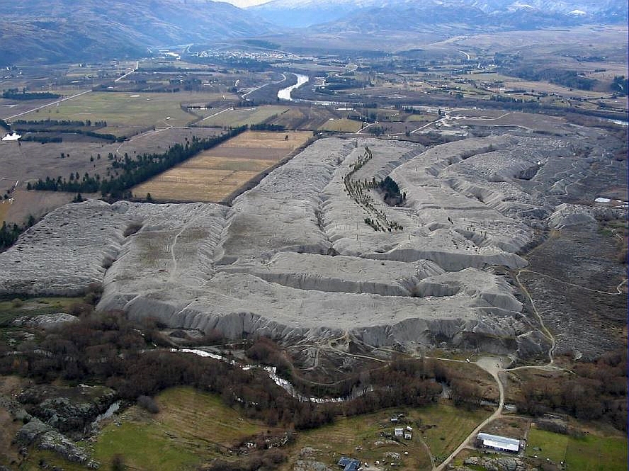
Dredges operated on Earnscleugh Flat from the 1890s through to 1963. The scale of the dredging was enormous – these are huge machines, churning through the river gravels, transformed the Flat into an eerie landscape of tailings, a huge snail trail of gravels marking the path of the dredges. Several dredges operated successfully between the Fraser River and Sandy Point: the Earnscleugh No. 1 (1896-1909), the Earnscleugh No. 2 (1899-1916), the Earnscleugh No. 3 (1903-1923), the Earnscleugh No. 5 (1908-1922) and the Glasgow (1901-1913) operated at Sandy Point. There was a modest revival in the dredging industry as the price of gold rose during the 1930s. The Clutha Dredging Company’s giant dredge, the Alexandra, worked into the 1960s. It was the last dredge operating in Otago.
Earnscleugh tailings epitomise the effect of dredging on the landscape. The dredges left behind them a landscape reflecting the different dredging technologies. The value of this landscape was recognised in 1990 when part of the dredge tailings were included in a historic reserve. In 2015, the tailings are alongside the Alexandra riverside walk, provide visitors with insight into the historic operations of these significant dredges.
List Entry Information
Status
Listed
List Entry Status
Historic Place Category 1
Access
Able to Visit
List Number
9267
Date Entered
20th May 2021
Date of Effect
10th June 2021
City/District Council
Central Otago District
Region
Otago Region
Extent of List Entry
Extent includes the land described as Pt Sec 206 Blk X Leaning Rock Survey District (NZ Gazette, 1990, p. 2619); Sec 1 SO 22853 (NZ Gazette, 1990 p. 2530); Lot 2 DP 26987 (NZ Gazette 2005 p. 2650, RT OT18D/1004); Sec 179 Blk X Leaning Rock Survey District (RT 18D/1005, land transfer authorised NZ Gazette 1999 p. 2609), Otago Land District and the archaeological sites and abandoned mining equipment associated with Earnscleugh Tailings thereon. The extent of List entry excludes the Operating Easement Sec 2 SO 342094, Legal River, Otago Land District.
Legal description
Pt Sec 206 Blk X Leaning Rock Survey District (NZ Gazette, 1990, p. 2619); Sec 1 SO 22853 (NZ Gazette, 1990 p. 2530); Lot 2 DP 26987 (NZ Gazette 2005 p. 2650, RT OT18D/1004); Sec 179 Blk X Leaning Rock Survey District (RT 18D/1005, land transfer authorised NZ Gazette 1999 p. 2609), Otago Land District.
Location Description
Access is from Marshall Road, 3 kilometres from Alexandra off Earnscleugh Road. Walking access is available down the true right of the Fraser River and crossing the foot bridge on The River Track.
Why is this place significant?
Historic Significance
Historical Significance or Value The Clutha River / Mata-au was central to the Otago gold rush and subsequent gold mining era, and to the evolution of alluvial gold mining technology, which culminated in the paddock dredge. The Alexandra region, including the Earnscleugh Flat, is historically significant as the place where much of this technological development took place. McCraw suggests that the first substantial water race on the Dunstan goldfield was dug in 1862 from the Fraser River to a sluicing claim at the mouth of the River, facilitating the first attempt at ground sluicing in the district. As documented by Chandler and Hall, ’gold dredging, in its origins, was almost peculiarly an Otago phenomenon’, and the development of a machine to dredge the bed of the Clutha and other rivers is ‘Otago’s unique contribution to the mining industry’.
Physical Significance
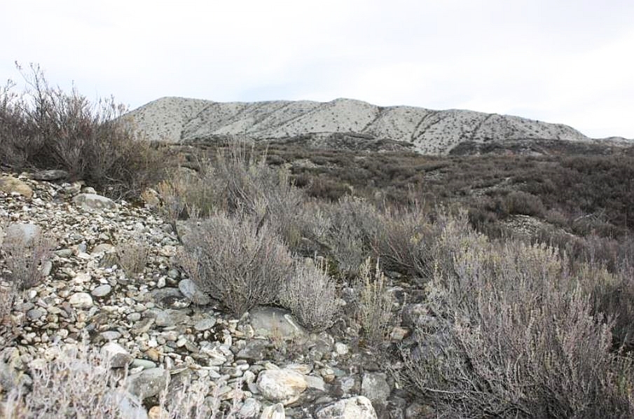
Aesthetic Significance or Value The Earnscleugh Tailings have significant aesthetic impact – the scale and scope of the tailings dwarf visitors, leaving them in an alien landscape. The towering piles of gravel, the abandoned mining equipment, the path snaking through the many kilometres of tailings provides an evocative understanding of the working of these huge machines. The wasteland provokes thinking about the effects of mining on the landscape. Archaeological Significance or Value The physical remains on the ground at the Earnscleugh Flat are significant in that they are the physical and visual representation of the region’s contribution to technological developments in alluvial gold mining, especially dredging. The remains reflect a linked sequence and range of alluvial gold mining technologies – nineteenth century ground sluicing, late nineteenth century river edge and paddock dredging, early twentieth century paddock dredging, mid-twentieth century paddock dredging – and tailing types – hand stacked herringbone tailings, mounded dredge tailings of various heights and potential centrifugal scatterings. This linked sequence is not known elsewhere in New Zealand. The Earnscleugh dredge tailings are the premier site in New Zealand for the preservation and interpretation of alluvial dredging in New Zealand. The dry climate of Central Otago does not encourage rampant revegetation as occurs on the West Coast, and the site is readily accessible to the public. Technological Significance or Value Amongst engineers, opinion has been expressed that gold dredging was New Zealand’s greatest engineering achievement, and Otago, for a time, was the leading world centre of design and construction. The evolution of dredge technology is therefore historically significant to the region, and it was to revolutionise the industry both nationally and internationally. Outside the Otago region, dredging was carried out nationally in Southland and Westland. Internationally, New Zealand dredging methods were successfully introduced to Australia, the United States, South America, British Columbia, Siberia, Sumatra, Africa etc. In California, dredging was carried out experimentally, and without success, for the first forty years, the industry eventuating when improvements based on the Otago system of dredging were introduced. People travelled from all over the world to investigate New Zealand’s dredging industry, and regional engineering foundries designed and built dredges to order for the overseas market. Some of the noteworthy developments in dredge technology that are associated with the Earnscleugh flat include the Earnscleugh No. 2’s bucket capacity. When launched in 1899 the Earnscleugh No. 2 dredge was the largest dredge in New Zealand, as a result of its 6.5 cubic feet bucket capacity. The Earnscleugh No. 3 dredge was one of the first electricity powered dredges in the country, powered by its own power scheme on the Fraser River. The dredge was launched in 1903; the peak year for dredges operating in Otago and Southland, and at the time she was the largest of her type yet built. When it ceased operation in 1923 the Earnscleugh No. 3 was the last dredge operating around Alexandra. The revival of dredging on the Earnscleugh flat from 1949 was only permissible as a result of the construction of the very much larger and powerful ‘Alexandra’ dredge. The ‘Alexandra’ dredge was one of only a few such dredges put to operation in Otago, and was the last to operate in the region.
Why is this place Category 1 / Category 2?
Detail Of Assessed Criteria
(a) The extent to which the place reflects important or representative aspects of New Zealand history The Earnscleugh Tailings represent a century of alluvial gold mining (1862-1963) on the banks of the Clutha River / Mata-au, and the evolution of dredge technology in New Zealand. The tailings illustrate the success of technology and provide a background for New Zealand’s significant influence on the international dredging industry. The dredge tailings are also representative of the economic and social contributions that dredging made to Alexandra and to Otago, and can be related to the wider debate around the loss of agricultural land to gold mining, giving the tailings special regional and national significance. (b) The association of the place with events, persons, or ideas of importance in New Zealand history The Earnscleugh Tailings are associated with Otago’s gold rushes, and in particular the development of gold dredging. The Earnscleugh Flat represents a hundred years of alluvial gold mining history, from ground sluicing in 1862 to the workings of the huge ‘Alexandra’ dredge in 1963. The tailings are associated with significant individuals and companies that played pivotal roles in the development of world leading technologies. The Earnscleugh Gold Dredging Company, who owned the Earnscleugh No. 1, 2, 3 and 5 dredges, ranks as one of the few really successful companies to survive for any length of time and prove highly profitable to its owners. (c) The potential of the place to provide knowledge of New Zealand history The physical remains on the Earnscleugh flat provide insight into what is a much larger sequence of dredge tailings on both banks of the Clutha River / Mata-au between Alexandra and Clyde, described by Hamel as the largest surviving area of dredge tailings in Otago. Compared to other dredge tailings, the Earnscleugh Tailings are reasonably intact. (e) The community association with, or public esteem for the place There is considerable public esteem for the Earnscleugh Tailings. Their importance was recognised when they were gazetted as historic reserve in 1990. The importance of dredging in Otago is recognised by the Otago Goldfields Heritage Trust, and included on the list of sites to visit on the Goldfields trail. Interpretation about the tailings is included on the popular Alexandra-Clyde 150th Anniversary Walk (River Track) which passes through the eastern edge of the tailings alongside the Clutha River / Mata-au. (f) The potential of the place for public education The Earnscleugh Tailings are accessible to the public via a walking track and provides visitors with a powerful vision of the scale and effect of gold dredging. The on-site interpretation adds to the impact and understanding of the place. The visibility and accessibility of the tailings contributes to their significance. (j) The importance of identifying rare types of historic places The Earnscleugh Tailings are relatively rare surviving examples of a linked sequence and range of alluvial gold mining technologies – nineteenth century ground sluicing, late nineteenth century river edge and paddock dredging, early twentieth century paddock dredging, mid-twentieth century paddock dredging – and tailing types – hand stacked herringbone tailings, mounded dredge tailings of various heights and potential centrifugal scatterings. This linked sequence is not known elsewhere in New Zealand. While other late nineteenth and early twentieth century dredge remains survive, these are naturally re-vegetating, and are already been lost to view. (k) The extent to which the place forms part of a wider historical and cultural area The Earnscleugh Tailings, as well as being a significant cultural landscape in their own right, are an outstanding part of the wider cultural landscape of gold mining in the Alexandra area. Summary of Significance or Values At Earnscleugh, on the banks of the Mata-au / Clutha River near Alexandra in Otago, mounds of stones and gravel that block out the sky create a desolate landscape that shows the massive scale of gold dredging in the nineteenth and twentieth centuries. The Earnscleugh Tailings are relatively rare surviving examples of a linked sequence and range of alluvial gold mining technologies – nineteenth century ground sluicing, late nineteenth century river edge and paddock dredging, early twentieth century paddock dredging, mid-twentieth century paddock dredging – and tailing types – hand stacked herringbone tailings, mounded dredge tailings of various heights and potential centrifugal scatterings. This linked sequence is not known elsewhere in New Zealand. The Earnscleugh Tailings have outstanding historic, technological and archaeological significance, representing the evolution of mining (and specifically dredging) and its associated technologies from the early 1860s through to the 1960s. It is considered that this place qualifies as a Category 1 historic place.
Why is this place significant?
Historic Significance
Historical Significance or Value The Clutha River / Mata-au was central to the Otago gold rush and subsequent gold mining era, and to the evolution of alluvial gold mining technology, which culminated in the paddock dredge. The Alexandra region, including the Earnscleugh Flat, is historically significant as the place where much of this technological development took place. McCraw suggests that the first substantial water race on the Dunstan goldfield was dug in 1862 from the Fraser River to a sluicing claim at the mouth of the River, facilitating the first attempt at ground sluicing in the district. As documented by Chandler and Hall, ’gold dredging, in its origins, was almost peculiarly an Otago phenomenon’, and the development of a machine to dredge the bed of the Clutha and other rivers is ‘Otago’s unique contribution to the mining industry’.
Physical Significance
Aesthetic Significance or Value The Earnscleugh Tailings have significant aesthetic impact – the scale and scope of the tailings dwarf visitors, leaving them in an alien landscape. The towering piles of gravel, the abandoned mining equipment, the path snaking through the many kilometres of tailings provides an evocative understanding of the working of these huge machines. The wasteland provokes thinking about the effects of mining on the landscape. Archaeological Significance or Value The physical remains on the ground at the Earnscleugh Flat are significant in that they are the physical and visual representation of the region’s contribution to technological developments in alluvial gold mining, especially dredging. The remains reflect a linked sequence and range of alluvial gold mining technologies – nineteenth century ground sluicing, late nineteenth century river edge and paddock dredging, early twentieth century paddock dredging, mid-twentieth century paddock dredging – and tailing types – hand stacked herringbone tailings, mounded dredge tailings of various heights and potential centrifugal scatterings. This linked sequence is not known elsewhere in New Zealand. The Earnscleugh dredge tailings are the premier site in New Zealand for the preservation and interpretation of alluvial dredging in New Zealand. The dry climate of Central Otago does not encourage rampant revegetation as occurs on the West Coast, and the site is readily accessible to the public. Technological Significance or Value Amongst engineers, opinion has been expressed that gold dredging was New Zealand’s greatest engineering achievement, and Otago, for a time, was the leading world centre of design and construction. The evolution of dredge technology is therefore historically significant to the region, and it was to revolutionise the industry both nationally and internationally. Outside the Otago region, dredging was carried out nationally in Southland and Westland. Internationally, New Zealand dredging methods were successfully introduced to Australia, the United States, South America, British Columbia, Siberia, Sumatra, Africa etc. In California, dredging was carried out experimentally, and without success, for the first forty years, the industry eventuating when improvements based on the Otago system of dredging were introduced. People travelled from all over the world to investigate New Zealand’s dredging industry, and regional engineering foundries designed and built dredges to order for the overseas market. Some of the noteworthy developments in dredge technology that are associated with the Earnscleugh flat include the Earnscleugh No. 2’s bucket capacity. When launched in 1899 the Earnscleugh No. 2 dredge was the largest dredge in New Zealand, as a result of its 6.5 cubic feet bucket capacity. The Earnscleugh No. 3 dredge was one of the first electricity powered dredges in the country, powered by its own power scheme on the Fraser River. The dredge was launched in 1903; the peak year for dredges operating in Otago and Southland, and at the time she was the largest of her type yet built. When it ceased operation in 1923 the Earnscleugh No. 3 was the last dredge operating around Alexandra. The revival of dredging on the Earnscleugh flat from 1949 was only permissible as a result of the construction of the very much larger and powerful ‘Alexandra’ dredge. The ‘Alexandra’ dredge was one of only a few such dredges put to operation in Otago, and was the last to operate in the region.
Why is this place Category 1 / Category 2?
Detail Of Assessed Criteria
(a) The extent to which the place reflects important or representative aspects of New Zealand history The Earnscleugh Tailings represent a century of alluvial gold mining (1862-1963) on the banks of the Clutha River / Mata-au, and the evolution of dredge technology in New Zealand. The tailings illustrate the success of technology and provide a background for New Zealand’s significant influence on the international dredging industry. The dredge tailings are also representative of the economic and social contributions that dredging made to Alexandra and to Otago, and can be related to the wider debate around the loss of agricultural land to gold mining, giving the tailings special regional and national significance. (b) The association of the place with events, persons, or ideas of importance in New Zealand history The Earnscleugh Tailings are associated with Otago’s gold rushes, and in particular the development of gold dredging. The Earnscleugh Flat represents a hundred years of alluvial gold mining history, from ground sluicing in 1862 to the workings of the huge ‘Alexandra’ dredge in 1963. The tailings are associated with significant individuals and companies that played pivotal roles in the development of world leading technologies. The Earnscleugh Gold Dredging Company, who owned the Earnscleugh No. 1, 2, 3 and 5 dredges, ranks as one of the few really successful companies to survive for any length of time and prove highly profitable to its owners. (c) The potential of the place to provide knowledge of New Zealand history The physical remains on the Earnscleugh flat provide insight into what is a much larger sequence of dredge tailings on both banks of the Clutha River / Mata-au between Alexandra and Clyde, described by Hamel as the largest surviving area of dredge tailings in Otago. Compared to other dredge tailings, the Earnscleugh Tailings are reasonably intact. (e) The community association with, or public esteem for the place There is considerable public esteem for the Earnscleugh Tailings. Their importance was recognised when they were gazetted as historic reserve in 1990. The importance of dredging in Otago is recognised by the Otago Goldfields Heritage Trust, and included on the list of sites to visit on the Goldfields trail. Interpretation about the tailings is included on the popular Alexandra-Clyde 150th Anniversary Walk (River Track) which passes through the eastern edge of the tailings alongside the Clutha River / Mata-au. (f) The potential of the place for public education The Earnscleugh Tailings are accessible to the public via a walking track and provides visitors with a powerful vision of the scale and effect of gold dredging. The on-site interpretation adds to the impact and understanding of the place. The visibility and accessibility of the tailings contributes to their significance. (j) The importance of identifying rare types of historic places The Earnscleugh Tailings are relatively rare surviving examples of a linked sequence and range of alluvial gold mining technologies – nineteenth century ground sluicing, late nineteenth century river edge and paddock dredging, early twentieth century paddock dredging, mid-twentieth century paddock dredging – and tailing types – hand stacked herringbone tailings, mounded dredge tailings of various heights and potential centrifugal scatterings. This linked sequence is not known elsewhere in New Zealand. While other late nineteenth and early twentieth century dredge remains survive, these are naturally re-vegetating, and are already been lost to view. (k) The extent to which the place forms part of a wider historical and cultural area The Earnscleugh Tailings, as well as being a significant cultural landscape in their own right, are an outstanding part of the wider cultural landscape of gold mining in the Alexandra area. Summary of Significance or Values At Earnscleugh, on the banks of the Mata-au / Clutha River near Alexandra in Otago, mounds of stones and gravel that block out the sky create a desolate landscape that shows the massive scale of gold dredging in the nineteenth and twentieth centuries. The Earnscleugh Tailings are relatively rare surviving examples of a linked sequence and range of alluvial gold mining technologies – nineteenth century ground sluicing, late nineteenth century river edge and paddock dredging, early twentieth century paddock dredging, mid-twentieth century paddock dredging – and tailing types – hand stacked herringbone tailings, mounded dredge tailings of various heights and potential centrifugal scatterings. This linked sequence is not known elsewhere in New Zealand. The Earnscleugh Tailings have outstanding historic, technological and archaeological significance, representing the evolution of mining (and specifically dredging) and its associated technologies from the early 1860s through to the 1960s. It is considered that this place qualifies as a Category 1 historic place.
Construction Details
Start Year
1899
Finish Year
1916
Type
Original Construction
Description
Earnscleugh No. 2 starts operating
Start Year
1903
Finish Year
1923
Type
Original Construction
Description
Earnscleugh No. 3 starts operating
Start Year
1908
Finish Year
1922
Type
Original Construction
Description
Earnscleugh No. 5 starts operating
Start Year
1909
Type
Other
Description
Earnscleugh No. 1 stops working
Start Year
1916
Type
Other
Description
Earnscleugh No. 2 stops working
Start Year
1922
Type
Other
Description
Earnscleugh No. 5 stops working
Start Year
1923
Type
Other
Description
Earnscleugh No. 3 stops working
Start Year
1936
Finish Year
1963
Type
Original Construction
Description
Alexandra Dredge launched
Start Year
1963
Type
Other
Description
Alexandra Dredge stops working
Type
Other
Description
Gold mining begins on Earnscleugh Flat
Period
1862
Start Year
1895
Finish Year
1909
Type
Original Construction
Description
Earnscleugh No. 1 starts operating
Early History The Mata-au is a significant waterway in the southern Te Wai Pounamu landscape. Commencing from the interior lakes; Hāwea, Wanaka and Whakatipu wai māori - the Mata-au meanders its way in a south-easterly direction over 338 kilometres to the coast. Weaving its way from mountains to the sea, the river has been used as an ara tawhito by successive iwi from the earliest, Hāwea and Rapuwai; then Waitaha and Kāti Māmoe before Kāi Tahu became the dominant iwi in the late 18th century. Battle sites are situated along the Mata-au as were consequential urupā. Far more numerous however are the nohoanga, mahinga kai and pā kāinga which were dotted along the river at strategic points as were the tauraka waka, the staging posts for those travelling along the river. One such tauraka waka was at Kā Moana Haehae (Lake Roxburgh), the junction of the Mata-au and Manuherekia awa. Nestled under the local mountain Tapuaenuku, the broad flat before the Mata-au physically merges with the Manuherekia, was an ideal place for harvesting resources such as weka, taramea, tikumu and tuna. The opportunity would also have been taken to gather resources to replenish clothing and footwear. As the Mata-au was a key ara tawhito for carrying pounamu and piriki (silcrete) from the interior to the coast, the flat would have also provided an ideal location to fashion or repair mōkihi before heading through the arduous gorge at the confluence of the two rivers. These seasonal activities continued through multiple generations prior to a change in land tenure when the controversial sale of land occurred during early colonial-Kāi Tahu encounters. Clutha farmer Nathanael Chalmers was guided into the area by Tūtūrau rangatira Reko and another man, Kaikōura, in 1853 and explored the upper Mata-au via the Cromwell flats. Once colonists found their way to the interior these traditional activities were curtailed, especially once European colonists ‘discovered’ gold. There is a statutory acknowledgement for Mata-au / Clutha River and a number of sites over which nohoanga entitlements have been granted in the Clutha area and along the length of the Mata-au / Clutha River. Where the Mata-au / Clutha River reaches the sea it is acknowledged as part of Te Tai Arai Te Uru (Otago Coastal Marine Area). Rush to the Clutha River In the 1860s, the Clutha River / Mata-au wound through a landscape marked by Māori ara (trails) and the wandering sheep of European sheep station owners, a vast landscape of rolling hills, rocky outcrops and tussock. In the early 1860s, the west bank of the river formed part of Run 249, Earnscleugh Station’s ‘old homestead run.’ In August 1862, peace was shattered when Horatio Hartley and Christopher Reilly discovered gold upriver. There is no kōrero or evidence to suggest that Māori were prevented from travelling at this time. The west bank of the Clutha River / Mata-au was soon swarming with miners working with picks and shovels. To remove the barren overburden, miners brought in water and began ground sluicing for gold. By September 1862, a ‘canal,’ or race, ‘more than a mile long’ had been dug from the Fraser River to a sluicing claim at the mouth of the river. Historian John McCraw suggests that this race was probably the first substantial water race on the Dunstan goldfield, and facilitated the first attempt at ground sluicing. By the middle of 1864 there were seven races conveying water from the Fraser River to sluicing claims on the west bank of the Clutha River / Mata-au, and Earnscleugh Flat. Parties worked the Earnscleugh Flat throughout the 1860s, using ground sluicing, with its associated races and water wheels. The year 1873 marked both the peak of sluicing claims on the west bank, with 24 working claims, and the beginning of a period of depression on the Dunstan goldfields. There was a brief revival in 1890, when the Sandy Point Gold Mining Company was formed to work a 21 acre hydraulic sluicing claim. Dredging As gold became more difficult to extract, technologies developed to allow miners to work new areas, or to rework old areas in different ways. Gold dredges were a particularly significant development – and one where New Zealand led the world. Charles Sew Hoy pioneered gold dredging, forming Shotover Big Beach Gold Mining Company in 1888, to mine near Queenstown. In 1889 the 'Sew Hoy dredge' was working successfully on ground even 'quite away from the river' – working the river flat as well as the river bed. The dredge’s ‘remarkable returns’ created a 'dredging fever' resulting in Otago's first gold-dredging boom’ from 1889 to 1891. Sew Hoy firmly established dredging as a commercially feasible and profitable branch of goldmining. Dredges had operated since the 1860s. In The Speculator’s Dream, Gold Dredging in Southern New Zealand, Hearn and Hargreaves detail the development and evolution of the gold dredge, from the river dredges (the spoon dredges, the first of which were operated in the Clutha River / Mata-au in 1863, and the current wheel dredge of the 1870s and 1880s) to the steam and bucket dredge, which worked the floodplains during the 1880s and 1890s. The steam and bucket dredge was first used on the Clutha in 1881, but it was not until 1889 that renewed enthusiasm for dredging gained momentum. Changes in dredge design allowed larger areas to be mined – and in the 1890s made Otago engineers world leaders in the design of gold dredges. The steam-powered bucket dredge design (which became known as the ‘New Zealand’ or ‘Standard’ dredge) was refined during the 1890s, and ‘the size and capacity of the machine to raise and treat ever larger quantities of wash increased.’ The New Zealand dredge was made of two pontoons carrying a bucket ladder and gold saving appliances. Internationally, ‘New Zealand dredging methods were successfully introduced to Australia, the United States, South America, British Columbia, Siberia, Sumatra, and Africa. In California, dredging was carried out experimentally, and without success, for the first forty years, the industry eventuating when improvements based on the Otago system of dredging were introduced. People travelled from all over the world to investigate New Zealand’s dredging industry, and regional engineering foundries designed and built dredges to order for the overseas market. Another major technological advance was the tailings elevator, invented in 1894, installed on the rear of the dredge allowing tailings to be deposited well clear of the dredge. Operators dug a pond or paddock that allowed the dredge to float and work its way through dry land, carrying its pond with it. The tailings elevator made ‘dry-land’ dredging possible, facilitating dredging on the low terraces next to the Clutha River / Mata-au. The dredges that worked their way from the Clutha into the low terraces of the Earnscleugh Flat dredged through, and largely destroyed, the workings of the earlier sluicing companies, using the water rights once held by these companies to replenish their dredge ponds. Dredging Earnscleugh Flat Dredges operated on Earnscleugh Flat from the 1890s through to 1963. The scale of the dredging was enormous – these are huge machines, churning through the river terraces, transformed the terraces into an eerie landscape of tailings, a huge snail trail of gravels marking their paths. Several dredges operated successfully between the Fraser River and Sandy Point: Earnscleugh No. 1 (1896-1909), the Earnscleugh No. 2 (1899-1916), the Earnscleugh No. 3 (1903-1923), the Earnscleugh No. 5 (1908-1922) and the Glasgow (1901-1913) at Sandy Point). The Ngapara Gold Dredging Company also operated its dredge for a time around the mouth of the Fraser River. Earnscleugh No. 1 started work on the Earnscleugh Flat in June 1896 on a 95 acre claim granted to Charles Weaver. Weaver, James Kelman and Alexander Black (of Cossens and Black engineers) were principal shareholders in the dredge. The dredge was doing so well the owners were reported in July 1898 to be ‘talking of building another dredge, larger than any yet built’. The No. 1 dredge was designed by E. Roberts and built by Anderson (Christchurch) and Cossens and Black (Dunedin). It was 90 feet (27.4 metres) long, carrying 2½ foot (0.76 metre) buckets, could dredge 38 foot (11.6 metres) deep and could stack tailings 16 feet (4.8 metres) high. H. G. Downie was dredgemaster. The claim included bank and river, but it was largely a bank working claim. Ten to fifteen acres (3-5 hectares) of ground had been worked by the Earnscleugh No. 1 by the end of 1898. Its success allowed a new dredge to be built – the Earnscleugh No. 2. The Earnscleugh No. 2 dredge was launched in 1898 and had the largest bucket capacity in New Zealand. It was 98 feet (29.8 metres) long, with an elevator that was 72 feet (21.9 metres) long and could stack tailings 40 feet (21.2 metres) high. Ritchie built the pontoon, while Cossens and Black engineered the machinery. The dredge’s 84 acre (34 hectare) claim held no part of the river, but was comprised entirely of a bank claim located to the back of the Earnscleugh No. 1 claim. The buckets measured 6 ½ cubic feet (.18 cubic metre). It burnt six tons of coal over 24 hours. Both the Earnscleugh No. 1 and No. 2 were coal-powered steam dredges. There was a coal track to each dredge, and the Earnscleugh Flat was crossed by tracks to service the dredges working the west bank terraces. The success of dredging in the 1890s led to renewed interest and to the second ‘boom’ of 1899-1900. By March 1899, companies had applied for claims covering most of the Clutha River / Mata-au from Beaumont to Alexandra. Around the Fraser River, by June 1899, ‘...every inch of the river frontage’ had been taken up, ‘and if any were left it [was] eagerly competed for.’ Principal shareholders in the Earnscleugh No. 1 and No. 2 dredges, Charles Weaver and James Kelman, also held the claim adjoining that of the Earnscleugh No. 2. Trading as Earnscleugh No. 3 Gold Dredging Company, Weaver and Kelman on behalf of the company, submitted an application for a special 100 acre (40.5 hectare) claim on Section 23, Block X, Leaning Rock Survey District. In 1899, the license was transferred to the Earnscleugh No. 3 Dredging and Power Company Ltd. They proposed to build a dredge powered by electricity using water from the Fraser River – the Earnscleugh No. 3 dredge. Construction of the Earnscleugh No. 3 dredge was completed in 1902. It was 132 feet (40.2 metres) long, with an 88 feet (26.8 metre) long bucket ladder that could dredge to a depth of 50 feet (15.2 metres), and with a 121 feet (36.9 metre) long elevator that could stack tailings to a height of 70 feet (21.3 metre). Ownership of the dredge was transferred to the Earnscleugh Gold Dredging Company Limited, following liquidation of the Earnscleugh No 3 Dredging and Power Company Ltd. The new company [Earnscleugh Gold Dredging Company] was incorporated in July 1901. Its shareholders were Charles Weaver, Patrick Weaver, James Kelman (dredge owner), Alexander Black (engineer), John McPherson, Ann Gilchrist, Margaret McPherson and Elizabeth Reid. The new company now owned all three Earnscleugh dredges. The dredges on the Earnscleugh Flat obtained consistent gold returns, allowing the company to increase its fleet. In 1905, the goldfields warden reported that the company had purchased an uncompleted dredge belonging to the unsuccessful Fraser Flat Company. They intended to this to be an electric dredge, to be called the Earnscleugh No 4, but it was never finished. The Company subsequently purchased the Dunstan Lead dredge in 1907, renaming it Earnscleugh No. 5. This dredge, converted to electricity in 1908, had a 120 feet (36.6 metre) long elevator that could stack tailings 60 feet (18.2 metres) high. The Earnscleugh Gold Dredging Company had all four of its dredges at work in 1908, but by 1909 the Earnscleugh No. 1 had been decommissioned. Even one dredge down, the Company was the largest dredging company in the country. The Earnscleugh No. 2 dredge ceased operating in 1916. By the end of 1918 gold production for the Company had reached 56,150 ounces, valued at £215,595. In 1919, the Earnscleugh No. 3 was working to a depth of 50 feet (15.2 metres) and the Earnscleugh No. 5 to a depth of 28 feet (8.5 metres). These were two of only five dredges still operating around Alexandra. By 1921, the two Earnscleugh Gold Dredging Company dredges were all that were left. The Earnscleugh No. 5 stopped working the following year, and the Earnscleugh No. 3, in 1923. The Earnscleugh Gold Dredging Company wound up voluntarily in August 1924. By the end of 1924, the dredging industry was largely over in Otago. The Company’s assets at the time included the No. 2, 3, 4 and 5 dredges. The Earnscleugh No. 3 was sold, and in 1926 was moved to the Upper Nevis, where it operated, unsuccessfully, between 1928 and 1934. The fate of the other dredges is less clear. Two are still shown on site on a 1929 geological survey map. In 2015, at least one dredge remains on the flat. The Earnscleugh Gold Dredging Company, who owned the Earnscleugh No. 1, 2, 3 and 5 dredges, ranks as one of the few really successful companies to survive for any length of time and prove highly profitable to its owners. There was a modest revival in the dredging industry as the price of gold rose during the 1930s. The Clutha Dredging Company was registered in London in April 1934, and took up work on the Clutha River / Mata-au from a point just above Alexandra downstream to Coal Creek. The Company’s dredge, the Alexandra, was 164 feet (50 metres) long, 44 feet (13.4 metres) wide and could dredge to a depth of 65 feet (19.8 metres), a giant compared with the earlier dredges. It was launched in May 1936 and started working in May 1937. The electrically-powered dredge worked until the outbreak of the Second World War, during which it was converted to a paddock dredge and fitted with an elevator. In 1943 the Alexandra worked the flats on the east bank of the Clutha River / Mata-au, opposite the mouth of the Fraser River, but it ran out of available land in mid-1949 moving across the river to Earnscleugh Flat. The Alexandra Dredge worked the Earnscleugh Flat for the next thirteen years. In September 1962, the Clutha Dredging Company announced it was to cease operation in June 1963. It ceased working in April 1963, due to a combination of rising costs, a fixed price for gold and lack of available land. It was the last dredge operating in Otago. The dredges left behind them a landscape reflecting the different dredging technologies. The value of this landscape was recognised in 1990 when part of the dredge tailings were included in a historic reserve. In 2020, the tailings alongside the Alexandra riverside walk, provide visitors with insight into the historic operations of these significant dredges.
Early History The Mata-au is a significant waterway in the southern Te Wai Pounamu landscape. Commencing from the interior lakes; Hāwea, Wanaka and Whakatipu wai māori - the Mata-au meanders its way in a south-easterly direction over 338 kilometres to the coast. Weaving its way from mountains to the sea, the river has been used as an ara tawhito by successive iwi from the earliest, Hāwea and Rapuwai; then Waitaha and Kāti Māmoe before Kāi Tahu became the dominant iwi in the late 18th century. Battle sites are situated along the Mata-au as were consequential urupā. Far more numerous however are the nohoanga, mahinga kai and pā kāinga which were dotted along the river at strategic points as were the tauraka waka, the staging posts for those travelling along the river. One such tauraka waka was at Kā Moana Haehae (Lake Roxburgh), the junction of the Mata-au and Manuherekia awa. Nestled under the local mountain Tapuaenuku, the broad flat before the Mata-au physically merges with the Manuherekia, was an ideal place for harvesting resources such as weka, taramea, tikumu and tuna. The opportunity would also have been taken to gather resources to replenish clothing and footwear. As the Mata-au was a key ara tawhito for carrying pounamu and piriki (silcrete) from the interior to the coast, the flat would have also provided an ideal location to fashion or repair mōkihi before heading through the arduous gorge at the confluence of the two rivers. These seasonal activities continued through multiple generations prior to a change in land tenure when the controversial sale of land occurred during early colonial-Kāi Tahu encounters. Clutha farmer Nathanael Chalmers was guided into the area by Tūtūrau rangatira Reko and another man, Kaikōura, in 1853 and explored the upper Mata-au via the Cromwell flats. Once colonists found their way to the interior these traditional activities were curtailed, especially once European colonists ‘discovered’ gold. There is a statutory acknowledgement for Mata-au / Clutha River and a number of sites over which nohoanga entitlements have been granted in the Clutha area and along the length of the Mata-au / Clutha River. Where the Mata-au / Clutha River reaches the sea it is acknowledged as part of Te Tai Arai Te Uru (Otago Coastal Marine Area). Rush to the Clutha River In the 1860s, the Clutha River / Mata-au wound through a landscape marked by Māori ara (trails) and the wandering sheep of European sheep station owners, a vast landscape of rolling hills, rocky outcrops and tussock. In the early 1860s, the west bank of the river formed part of Run 249, Earnscleugh Station’s ‘old homestead run.’ In August 1862, peace was shattered when Horatio Hartley and Christopher Reilly discovered gold upriver. There is no kōrero or evidence to suggest that Māori were prevented from travelling at this time. The west bank of the Clutha River / Mata-au was soon swarming with miners working with picks and shovels. To remove the barren overburden, miners brought in water and began ground sluicing for gold. By September 1862, a ‘canal,’ or race, ‘more than a mile long’ had been dug from the Fraser River to a sluicing claim at the mouth of the river. Historian John McCraw suggests that this race was probably the first substantial water race on the Dunstan goldfield, and facilitated the first attempt at ground sluicing. By the middle of 1864 there were seven races conveying water from the Fraser River to sluicing claims on the west bank of the Clutha River / Mata-au, and Earnscleugh Flat. Parties worked the Earnscleugh Flat throughout the 1860s, using ground sluicing, with its associated races and water wheels. The year 1873 marked both the peak of sluicing claims on the west bank, with 24 working claims, and the beginning of a period of depression on the Dunstan goldfields. There was a brief revival in 1890, when the Sandy Point Gold Mining Company was formed to work a 21 acre hydraulic sluicing claim. Dredging As gold became more difficult to extract, technologies developed to allow miners to work new areas, or to rework old areas in different ways. Gold dredges were a particularly significant development – and one where New Zealand led the world. Charles Sew Hoy pioneered gold dredging, forming Shotover Big Beach Gold Mining Company in 1888, to mine near Queenstown. In 1889 the 'Sew Hoy dredge' was working successfully on ground even 'quite away from the river' – working the river flat as well as the river bed. The dredge’s ‘remarkable returns’ created a 'dredging fever' resulting in Otago's first gold-dredging boom’ from 1889 to 1891. Sew Hoy firmly established dredging as a commercially feasible and profitable branch of goldmining. Dredges had operated since the 1860s. In The Speculator’s Dream, Gold Dredging in Southern New Zealand, Hearn and Hargreaves detail the development and evolution of the gold dredge, from the river dredges (the spoon dredges, the first of which were operated in the Clutha River / Mata-au in 1863, and the current wheel dredge of the 1870s and 1880s) to the steam and bucket dredge, which worked the floodplains during the 1880s and 1890s. The steam and bucket dredge was first used on the Clutha in 1881, but it was not until 1889 that renewed enthusiasm for dredging gained momentum. Changes in dredge design allowed larger areas to be mined – and in the 1890s made Otago engineers world leaders in the design of gold dredges. The steam-powered bucket dredge design (which became known as the ‘New Zealand’ or ‘Standard’ dredge) was refined during the 1890s, and ‘the size and capacity of the machine to raise and treat ever larger quantities of wash increased.’ The New Zealand dredge was made of two pontoons carrying a bucket ladder and gold saving appliances. Internationally, ‘New Zealand dredging methods were successfully introduced to Australia, the United States, South America, British Columbia, Siberia, Sumatra, and Africa. In California, dredging was carried out experimentally, and without success, for the first forty years, the industry eventuating when improvements based on the Otago system of dredging were introduced. People travelled from all over the world to investigate New Zealand’s dredging industry, and regional engineering foundries designed and built dredges to order for the overseas market. Another major technological advance was the tailings elevator, invented in 1894, installed on the rear of the dredge allowing tailings to be deposited well clear of the dredge. Operators dug a pond or paddock that allowed the dredge to float and work its way through dry land, carrying its pond with it. The tailings elevator made ‘dry-land’ dredging possible, facilitating dredging on the low terraces next to the Clutha River / Mata-au. The dredges that worked their way from the Clutha into the low terraces of the Earnscleugh Flat dredged through, and largely destroyed, the workings of the earlier sluicing companies, using the water rights once held by these companies to replenish their dredge ponds. Dredging Earnscleugh Flat Dredges operated on Earnscleugh Flat from the 1890s through to 1963. The scale of the dredging was enormous – these are huge machines, churning through the river terraces, transformed the terraces into an eerie landscape of tailings, a huge snail trail of gravels marking their paths. Several dredges operated successfully between the Fraser River and Sandy Point: Earnscleugh No. 1 (1896-1909), the Earnscleugh No. 2 (1899-1916), the Earnscleugh No. 3 (1903-1923), the Earnscleugh No. 5 (1908-1922) and the Glasgow (1901-1913) at Sandy Point). The Ngapara Gold Dredging Company also operated its dredge for a time around the mouth of the Fraser River. Earnscleugh No. 1 started work on the Earnscleugh Flat in June 1896 on a 95 acre claim granted to Charles Weaver. Weaver, James Kelman and Alexander Black (of Cossens and Black engineers) were principal shareholders in the dredge. The dredge was doing so well the owners were reported in July 1898 to be ‘talking of building another dredge, larger than any yet built’. The No. 1 dredge was designed by E. Roberts and built by Anderson (Christchurch) and Cossens and Black (Dunedin). It was 90 feet (27.4 metres) long, carrying 2½ foot (0.76 metre) buckets, could dredge 38 foot (11.6 metres) deep and could stack tailings 16 feet (4.8 metres) high. H. G. Downie was dredgemaster. The claim included bank and river, but it was largely a bank working claim. Ten to fifteen acres (3-5 hectares) of ground had been worked by the Earnscleugh No. 1 by the end of 1898. Its success allowed a new dredge to be built – the Earnscleugh No. 2. The Earnscleugh No. 2 dredge was launched in 1898 and had the largest bucket capacity in New Zealand. It was 98 feet (29.8 metres) long, with an elevator that was 72 feet (21.9 metres) long and could stack tailings 40 feet (21.2 metres) high. Ritchie built the pontoon, while Cossens and Black engineered the machinery. The dredge’s 84 acre (34 hectare) claim held no part of the river, but was comprised entirely of a bank claim located to the back of the Earnscleugh No. 1 claim. The buckets measured 6 ½ cubic feet (.18 cubic metre). It burnt six tons of coal over 24 hours. Both the Earnscleugh No. 1 and No. 2 were coal-powered steam dredges. There was a coal track to each dredge, and the Earnscleugh Flat was crossed by tracks to service the dredges working the west bank terraces. The success of dredging in the 1890s led to renewed interest and to the second ‘boom’ of 1899-1900. By March 1899, companies had applied for claims covering most of the Clutha River / Mata-au from Beaumont to Alexandra. Around the Fraser River, by June 1899, ‘...every inch of the river frontage’ had been taken up, ‘and if any were left it [was] eagerly competed for.’ Principal shareholders in the Earnscleugh No. 1 and No. 2 dredges, Charles Weaver and James Kelman, also held the claim adjoining that of the Earnscleugh No. 2. Trading as Earnscleugh No. 3 Gold Dredging Company, Weaver and Kelman on behalf of the company, submitted an application for a special 100 acre (40.5 hectare) claim on Section 23, Block X, Leaning Rock Survey District. In 1899, the license was transferred to the Earnscleugh No. 3 Dredging and Power Company Ltd. They proposed to build a dredge powered by electricity using water from the Fraser River – the Earnscleugh No. 3 dredge. Construction of the Earnscleugh No. 3 dredge was completed in 1902. It was 132 feet (40.2 metres) long, with an 88 feet (26.8 metre) long bucket ladder that could dredge to a depth of 50 feet (15.2 metres), and with a 121 feet (36.9 metre) long elevator that could stack tailings to a height of 70 feet (21.3 metre). Ownership of the dredge was transferred to the Earnscleugh Gold Dredging Company Limited, following liquidation of the Earnscleugh No 3 Dredging and Power Company Ltd. The new company [Earnscleugh Gold Dredging Company] was incorporated in July 1901. Its shareholders were Charles Weaver, Patrick Weaver, James Kelman (dredge owner), Alexander Black (engineer), John McPherson, Ann Gilchrist, Margaret McPherson and Elizabeth Reid. The new company now owned all three Earnscleugh dredges. The dredges on the Earnscleugh Flat obtained consistent gold returns, allowing the company to increase its fleet. In 1905, the goldfields warden reported that the company had purchased an uncompleted dredge belonging to the unsuccessful Fraser Flat Company. They intended to this to be an electric dredge, to be called the Earnscleugh No 4, but it was never finished. The Company subsequently purchased the Dunstan Lead dredge in 1907, renaming it Earnscleugh No. 5. This dredge, converted to electricity in 1908, had a 120 feet (36.6 metre) long elevator that could stack tailings 60 feet (18.2 metres) high. The Earnscleugh Gold Dredging Company had all four of its dredges at work in 1908, but by 1909 the Earnscleugh No. 1 had been decommissioned. Even one dredge down, the Company was the largest dredging company in the country. The Earnscleugh No. 2 dredge ceased operating in 1916. By the end of 1918 gold production for the Company had reached 56,150 ounces, valued at £215,595. In 1919, the Earnscleugh No. 3 was working to a depth of 50 feet (15.2 metres) and the Earnscleugh No. 5 to a depth of 28 feet (8.5 metres). These were two of only five dredges still operating around Alexandra. By 1921, the two Earnscleugh Gold Dredging Company dredges were all that were left. The Earnscleugh No. 5 stopped working the following year, and the Earnscleugh No. 3, in 1923. The Earnscleugh Gold Dredging Company wound up voluntarily in August 1924. By the end of 1924, the dredging industry was largely over in Otago. The Company’s assets at the time included the No. 2, 3, 4 and 5 dredges. The Earnscleugh No. 3 was sold, and in 1926 was moved to the Upper Nevis, where it operated, unsuccessfully, between 1928 and 1934. The fate of the other dredges is less clear. Two are still shown on site on a 1929 geological survey map. In 2015, at least one dredge remains on the flat. The Earnscleugh Gold Dredging Company, who owned the Earnscleugh No. 1, 2, 3 and 5 dredges, ranks as one of the few really successful companies to survive for any length of time and prove highly profitable to its owners. There was a modest revival in the dredging industry as the price of gold rose during the 1930s. The Clutha Dredging Company was registered in London in April 1934, and took up work on the Clutha River / Mata-au from a point just above Alexandra downstream to Coal Creek. The Company’s dredge, the Alexandra, was 164 feet (50 metres) long, 44 feet (13.4 metres) wide and could dredge to a depth of 65 feet (19.8 metres), a giant compared with the earlier dredges. It was launched in May 1936 and started working in May 1937. The electrically-powered dredge worked until the outbreak of the Second World War, during which it was converted to a paddock dredge and fitted with an elevator. In 1943 the Alexandra worked the flats on the east bank of the Clutha River / Mata-au, opposite the mouth of the Fraser River, but it ran out of available land in mid-1949 moving across the river to Earnscleugh Flat. The Alexandra Dredge worked the Earnscleugh Flat for the next thirteen years. In September 1962, the Clutha Dredging Company announced it was to cease operation in June 1963. It ceased working in April 1963, due to a combination of rising costs, a fixed price for gold and lack of available land. It was the last dredge operating in Otago. The dredges left behind them a landscape reflecting the different dredging technologies. The value of this landscape was recognised in 1990 when part of the dredge tailings were included in a historic reserve. In 2020, the tailings alongside the Alexandra riverside walk, provide visitors with insight into the historic operations of these significant dredges.
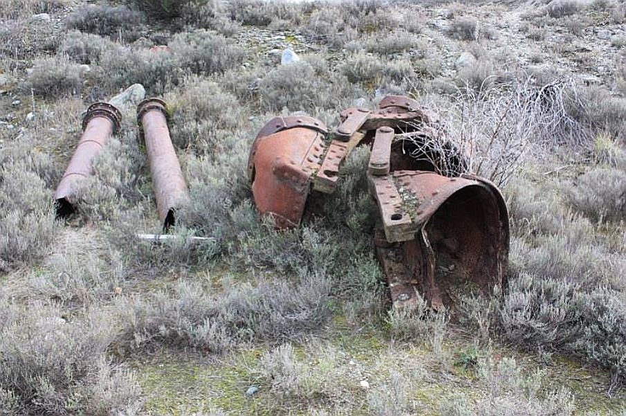
Current Description Setting The Earnscleugh Dredge Tailings Historic Reserve is situated on the true right bank of the Clutha River / Mata-au at Alexandra. The reserve is located on part of Earnscleugh Flat, a level plain of Pleistocene gravels between the river and the foothills of the Old Man / Kōpūwai, Old Woman and Cairnmuir Ranges. The reserve covers approximately 165.5 hectares of primarily dredge tailings extending north from the Fraser River (a tributary of the Clutha River / Mata-au) to McPherson Road, and inland from Crown land next to the Clutha River / Mata-au to the landward edge of the tailings. Physical Description The alluvial gold mining at the Earnscleugh Flat can be divided into two broad phases – early sluicing and paddock dredging. The latter activity cut through, and largely destroyed, the early sluicing remains, although localities of sluice faces/workings, herringbone tailings, sluice channels and tail races survive, creating a mixed physical and archaeological landscape. The tailings are the truncated remains of a series of dredging operations, and chiefly the physical remains of the last and largest dredge to have operated on the flat, the Clutha Company’s ‘Alexandra’ dredge. The dredge’s physical remains are dominated by its tailings (variably mounded or levelled), although other features include its path through the flat, its terminal faces and its dredge ponds. It is possible to trace the path of the ‘Alexandra’ dredge through several runs of tailings from the point where it left the river, to where it ceased operating in 1963 by the Fraser River. The dredge’s point of entry from the Clutha River / Mata-au, with its associated features, lies outside the boundary of the Reserve, but is included within the List entry. The truncated physical remains of earlier dredge operations are present on the north and northeast sides of the Reserve. As with the physical remains of the ‘Alexandra’ dredge, the physical remains of the earlier dredges include their mounded tailings, dredge paths, terminal faces, and dredge ponds. The earlier tailings are distinguishable from those of the ‘Alexandra’ dredge by their lower height. The remains are those of the Earnscleugh Gold Dredging Company operations on the flat, namely the Earnscleugh No. 3 dredge and potentially the Earnscleugh Nos. 2 and 5 dredges. The greater portion of the early paddock dredge workings by the four dredges of the Earnscleugh Gold Dredging Company are located outside the reserve, on the low terrace between the Reserve’s eastern boundary and the Clutha River / Mata-au, but are within the List entry. The once more extensive ground sluicing remains that were present on the Earnscleugh Flat are represented within the reserve by remnant sluice workings, herringbone tailings and sluice channels. Highly visible remnant herringbone tailings survive along the southeast boundary, on the edge of a probable terrace above the Clutha River / Mata-au’s natural flood plain, and at the inland extent of the early paddock dredge workings. The herringbone tailings can be seen both south and north of the signed Earnscleugh Tailings Walk junction to the lookout point. Coster recorded a surviving area of about 2000m² of sluice channels and hand stacked herringbone tailings in the south and southeast portion of the reserve. A second area of known ground sluicing survives in the Reserve, on un-dredged ground near the McPherson Road gate. These workings are next to the damaged (via gravel extraction) terminal face of an early twentieth century dredge run. Site record G42/166 also records a small area of four parallel lines of sluice tailings with stone retaining walls amongst the tailings, in the extreme northeast corner of the reserve. A sense of the myriad of physical archaeological features from nineteenth century ground sluicing operations can be gained from aerial photography pre-dating 1949, that show sluice workings, sluice faces, supply race and tail race systems, sluice and herringbone tailings etc. that survived the late nineteenth and early twentieth century paddock dredging. The aerial photograph also shows a dwelling that, along with much of the sluice remains, was consumed by the ‘Alexandra’ dredge. The sluice workings and features that survived the late nineteenth and early twentieth century dredging nearest the Fraser River presumably did so as they were located on higher ground, where the larger of the Earnscleugh Gold Dredging Company paddock dredges did not operate. Various discarded metal items from the dredges, such as buckets, steel rope, riveted pipes, a tumbler, and a winch can be found in the reserve. These discarded dredge items were formerly more prevalent in the reserve, including a silt wheel from the Earnscleugh No 3 dredge and a water wheel. As a result of theft and/or attempted theft in the recent past many metal items were uplifted by the Department of Conservation. These items were catalogued and stored at the Department’s yard on Boundary Road in Alexandra. Archaeologist Matt Schmidt has also recorded the existence of a dredge in a pond on the south side of the ‘Alexandra’ dredge entry path from the Clutha River / Mata-au. Schmidt has questioned whether the remains could be that of either the Earnscleugh No 1 or No 2 dredge. The patches of unworked ground are interesting. Found primarily around the perimeter of the Reserve, or between the runs of different dredges, the patches of un-worked ground show the original ground surface and height, providing a stark contrast with the altered surface and the varying heights of the dredge tailings. The remains of the operations of the Ngapara dredge, which disposed of its tailings by centrifugal scattering, are thought to survive near the Marshall Road entrance to the tailings. There has been no attempt to identify, or to verify the existence of tailings from this dredge on the ground. Significance of Dredging The survival and development of the town of Alexandra is inseparable from the dredging industry. The dredging industry had a significant effect on the social and economic fortune of the town. In McCraw’s view, ‘the arrival of the steam gold dredge at Alexandra came in the nick of time, and may well have saved the place from becoming a ghost town.’ From the mid-1890s, and into the early years of the twentieth century, especially during the boom of 1899-1900, the gold dredging industry was at its peak. Alexandra was at the centre of international developments, and much of the population would have been connected in some way with the gold dredging industry. Being highly speculative, many individuals, companies and shareholders tried their hand in the industry. The boom effects were felt throughout the region, especially in Dunedin, where engineering manufacturing firms were heavily involved in the design and production of dredges and components, for both national and overseas markets. For the above reasons it is likely that there are many individuals with potential cultural connections with dredging currently living in and around Alexandra, and with dredging on the Earnscleugh Flat. There are likely to be descendants of the shareholders of the Earnscleugh Gold Dredging Company, the syndicate that operated the four Earnscleugh dredges on the Earnscleugh flat. The shareholders were brothers Charles and Patrick Weaver and their Mary-Ann Weaver, James Kelman (owner of Alexandra Foundry) and members of the Kelman family, John and Mary McPherson and Alexander Black, of Crossans and Black (a Dunedin foundry). Shareholding never passed from these family groupings, other than through inheritance, throughout the life of the company. It is not unreasonable to assume that present day McPherson Road got its name from the McPherson family connection with the flat. Much debate has occurred in the past on the damaging nature of dredging on agricultural and/or development land. One regional group of people, inspired by the work of Richard St Barbe Baker, famous for the post World War Two enterprise ‘Men of the Trees,’ saw the dredge tailings on the Earnscleugh Flat as representative of ‘desertification’. Desertification was a primary concern of St Barbe Baker following his wartime experience of the process in North Africa and the Mediterranean. The group planted pine trees on the tailings in acknowledgment of the commitment of the ‘Men of the Trees’ to desertification and the loss of fertile land. Central Otago as a whole was seen as the New Zealand parallel to the worries of semi-arid settlements in North Africa and the Mediterranean. The tree plantings by the group on the dredge tailings are essentially in response to the ‘Men of the Trees’ collective principal of stewardship. Coster highlights the interpretable physical remains in and around the historic reserve. The physical features, significant in aiding and understanding the sequence of mining include ground sluicing near the McPherson Road gate, hand stacked herringbone tailings near the Marshall Road entrance, the mounds of low dredge tailings on the riverside, the various higher ridges of tailings from the different larger dredges run paths and potential centrifugal scatterings. The physical features, significant in aiding and understanding the process of dredging include a dredge, the entry path of the ‘Alexandra’ dredge from the river, the undisturbed dredge runs and terminal faces, the areas where the runs of different dredges adjoin each other, dredge ponds, dredge artefacts, terminal faces and pockets of un-worked ground. The fact that there has been the purposeful planting of trees on the tailings, and that much of the mounded surface formation of the ‘Alexandra’ dredge tailings have been levelled, also allows for interpretation of the debate around the negative effects of dredging, and the attempts made to restore land to agricultural (or other) use. The full range of technologies and tailing types are not represented within the boundary of the Historic Reserve, but are included within the List entry. The late nineteenth century river edge and paddock dredge remains are outside the reserve but within the List entry. These, and much of the early twentieth century paddock dredge tailings (including a dredge in a dredge pond) are situated on Crown land set apart for hydro purposes between the eastern boundary of the Reserve and the Clutha River / Mata-au. The integrity of the complete sequence of technologies and physical remains is crucial to the on-going significance of the technologies and physical remains. The intactness of the Earnscleugh Tailings contrast with much of the dredge tailings elsewhere on the river, which have in places been damaged, destroyed or modified e.g. for development land around Alexandra, for quarrying on both banks, including for construction of the Clyde Dam and for the associated roading. The tailings from the Lowburn Dredge (1940-1952), which operated on the Clutha River / Mata-au north of Cromwell, and which would have been comparable in terms of age and size to the tailings of the ‘Alexandra’ dredge, were lost as a result of damming on the Clutha River / Mata-au. The dredge tailings visibility and accessibility contributes to their significance, as these are linked to the interpretability of the Historic Reserve. The visibility of the physical remains is primarily a result of the ‘Alexandra’ dredge’s run paths, which, as the most recent runs on the flat, have had the least amount of time to re-vegetate . The late nineteenth and early twentieth century dredge remains are naturally re-vegetating, as are many of equivalently dated tailings elsewhere. Comparatively, dredge tailings of similar age and size already lost to view as a result of vegetation growth include the workings of the ‘Kaniere’ dredge (1938-1953), behind Hokitika, on the West Coast. Elsewhere on the West Coast, there is a large area of naturally re-vegetating twentieth century paddock dredge remains at Ngahere, as well as visible modern tailings from the ‘Kanieri’ dredge (1989-2013). Similarly, there is a mix of visible river dredge tailings at the junction of the Little Grey River and Upper Grey River (date unknown) and re-vegetating paddock tailings near Ikamatua, while a large area of dredge workings at the junction of the Taramakau River and Greenstone River / Hokonui near Kumara is also naturally re-vegetating.
Current Description Setting The Earnscleugh Dredge Tailings Historic Reserve is situated on the true right bank of the Clutha River / Mata-au at Alexandra. The reserve is located on part of Earnscleugh Flat, a level plain of Pleistocene gravels between the river and the foothills of the Old Man / Kōpūwai, Old Woman and Cairnmuir Ranges. The reserve covers approximately 165.5 hectares of primarily dredge tailings extending north from the Fraser River (a tributary of the Clutha River / Mata-au) to McPherson Road, and inland from Crown land next to the Clutha River / Mata-au to the landward edge of the tailings. Physical Description The alluvial gold mining at the Earnscleugh Flat can be divided into two broad phases – early sluicing and paddock dredging. The latter activity cut through, and largely destroyed, the early sluicing remains, although localities of sluice faces/workings, herringbone tailings, sluice channels and tail races survive, creating a mixed physical and archaeological landscape. The tailings are the truncated remains of a series of dredging operations, and chiefly the physical remains of the last and largest dredge to have operated on the flat, the Clutha Company’s ‘Alexandra’ dredge. The dredge’s physical remains are dominated by its tailings (variably mounded or levelled), although other features include its path through the flat, its terminal faces and its dredge ponds. It is possible to trace the path of the ‘Alexandra’ dredge through several runs of tailings from the point where it left the river, to where it ceased operating in 1963 by the Fraser River. The dredge’s point of entry from the Clutha River / Mata-au, with its associated features, lies outside the boundary of the Reserve, but is included within the List entry. The truncated physical remains of earlier dredge operations are present on the north and northeast sides of the Reserve. As with the physical remains of the ‘Alexandra’ dredge, the physical remains of the earlier dredges include their mounded tailings, dredge paths, terminal faces, and dredge ponds. The earlier tailings are distinguishable from those of the ‘Alexandra’ dredge by their lower height. The remains are those of the Earnscleugh Gold Dredging Company operations on the flat, namely the Earnscleugh No. 3 dredge and potentially the Earnscleugh Nos. 2 and 5 dredges. The greater portion of the early paddock dredge workings by the four dredges of the Earnscleugh Gold Dredging Company are located outside the reserve, on the low terrace between the Reserve’s eastern boundary and the Clutha River / Mata-au, but are within the List entry. The once more extensive ground sluicing remains that were present on the Earnscleugh Flat are represented within the reserve by remnant sluice workings, herringbone tailings and sluice channels. Highly visible remnant herringbone tailings survive along the southeast boundary, on the edge of a probable terrace above the Clutha River / Mata-au’s natural flood plain, and at the inland extent of the early paddock dredge workings. The herringbone tailings can be seen both south and north of the signed Earnscleugh Tailings Walk junction to the lookout point. Coster recorded a surviving area of about 2000m² of sluice channels and hand stacked herringbone tailings in the south and southeast portion of the reserve. A second area of known ground sluicing survives in the Reserve, on un-dredged ground near the McPherson Road gate. These workings are next to the damaged (via gravel extraction) terminal face of an early twentieth century dredge run. Site record G42/166 also records a small area of four parallel lines of sluice tailings with stone retaining walls amongst the tailings, in the extreme northeast corner of the reserve. A sense of the myriad of physical archaeological features from nineteenth century ground sluicing operations can be gained from aerial photography pre-dating 1949, that show sluice workings, sluice faces, supply race and tail race systems, sluice and herringbone tailings etc. that survived the late nineteenth and early twentieth century paddock dredging. The aerial photograph also shows a dwelling that, along with much of the sluice remains, was consumed by the ‘Alexandra’ dredge. The sluice workings and features that survived the late nineteenth and early twentieth century dredging nearest the Fraser River presumably did so as they were located on higher ground, where the larger of the Earnscleugh Gold Dredging Company paddock dredges did not operate. Various discarded metal items from the dredges, such as buckets, steel rope, riveted pipes, a tumbler, and a winch can be found in the reserve. These discarded dredge items were formerly more prevalent in the reserve, including a silt wheel from the Earnscleugh No 3 dredge and a water wheel. As a result of theft and/or attempted theft in the recent past many metal items were uplifted by the Department of Conservation. These items were catalogued and stored at the Department’s yard on Boundary Road in Alexandra. Archaeologist Matt Schmidt has also recorded the existence of a dredge in a pond on the south side of the ‘Alexandra’ dredge entry path from the Clutha River / Mata-au. Schmidt has questioned whether the remains could be that of either the Earnscleugh No 1 or No 2 dredge. The patches of unworked ground are interesting. Found primarily around the perimeter of the Reserve, or between the runs of different dredges, the patches of un-worked ground show the original ground surface and height, providing a stark contrast with the altered surface and the varying heights of the dredge tailings. The remains of the operations of the Ngapara dredge, which disposed of its tailings by centrifugal scattering, are thought to survive near the Marshall Road entrance to the tailings. There has been no attempt to identify, or to verify the existence of tailings from this dredge on the ground. Significance of Dredging The survival and development of the town of Alexandra is inseparable from the dredging industry. The dredging industry had a significant effect on the social and economic fortune of the town. In McCraw’s view, ‘the arrival of the steam gold dredge at Alexandra came in the nick of time, and may well have saved the place from becoming a ghost town.’ From the mid-1890s, and into the early years of the twentieth century, especially during the boom of 1899-1900, the gold dredging industry was at its peak. Alexandra was at the centre of international developments, and much of the population would have been connected in some way with the gold dredging industry. Being highly speculative, many individuals, companies and shareholders tried their hand in the industry. The boom effects were felt throughout the region, especially in Dunedin, where engineering manufacturing firms were heavily involved in the design and production of dredges and components, for both national and overseas markets. For the above reasons it is likely that there are many individuals with potential cultural connections with dredging currently living in and around Alexandra, and with dredging on the Earnscleugh Flat. There are likely to be descendants of the shareholders of the Earnscleugh Gold Dredging Company, the syndicate that operated the four Earnscleugh dredges on the Earnscleugh flat. The shareholders were brothers Charles and Patrick Weaver and their Mary-Ann Weaver, James Kelman (owner of Alexandra Foundry) and members of the Kelman family, John and Mary McPherson and Alexander Black, of Crossans and Black (a Dunedin foundry). Shareholding never passed from these family groupings, other than through inheritance, throughout the life of the company. It is not unreasonable to assume that present day McPherson Road got its name from the McPherson family connection with the flat. Much debate has occurred in the past on the damaging nature of dredging on agricultural and/or development land. One regional group of people, inspired by the work of Richard St Barbe Baker, famous for the post World War Two enterprise ‘Men of the Trees,’ saw the dredge tailings on the Earnscleugh Flat as representative of ‘desertification’. Desertification was a primary concern of St Barbe Baker following his wartime experience of the process in North Africa and the Mediterranean. The group planted pine trees on the tailings in acknowledgment of the commitment of the ‘Men of the Trees’ to desertification and the loss of fertile land. Central Otago as a whole was seen as the New Zealand parallel to the worries of semi-arid settlements in North Africa and the Mediterranean. The tree plantings by the group on the dredge tailings are essentially in response to the ‘Men of the Trees’ collective principal of stewardship. Coster highlights the interpretable physical remains in and around the historic reserve. The physical features, significant in aiding and understanding the sequence of mining include ground sluicing near the McPherson Road gate, hand stacked herringbone tailings near the Marshall Road entrance, the mounds of low dredge tailings on the riverside, the various higher ridges of tailings from the different larger dredges run paths and potential centrifugal scatterings. The physical features, significant in aiding and understanding the process of dredging include a dredge, the entry path of the ‘Alexandra’ dredge from the river, the undisturbed dredge runs and terminal faces, the areas where the runs of different dredges adjoin each other, dredge ponds, dredge artefacts, terminal faces and pockets of un-worked ground. The fact that there has been the purposeful planting of trees on the tailings, and that much of the mounded surface formation of the ‘Alexandra’ dredge tailings have been levelled, also allows for interpretation of the debate around the negative effects of dredging, and the attempts made to restore land to agricultural (or other) use. The full range of technologies and tailing types are not represented within the boundary of the Historic Reserve, but are included within the List entry. The late nineteenth century river edge and paddock dredge remains are outside the reserve but within the List entry. These, and much of the early twentieth century paddock dredge tailings (including a dredge in a dredge pond) are situated on Crown land set apart for hydro purposes between the eastern boundary of the Reserve and the Clutha River / Mata-au. The integrity of the complete sequence of technologies and physical remains is crucial to the on-going significance of the technologies and physical remains. The intactness of the Earnscleugh Tailings contrast with much of the dredge tailings elsewhere on the river, which have in places been damaged, destroyed or modified e.g. for development land around Alexandra, for quarrying on both banks, including for construction of the Clyde Dam and for the associated roading. The tailings from the Lowburn Dredge (1940-1952), which operated on the Clutha River / Mata-au north of Cromwell, and which would have been comparable in terms of age and size to the tailings of the ‘Alexandra’ dredge, were lost as a result of damming on the Clutha River / Mata-au. The dredge tailings visibility and accessibility contributes to their significance, as these are linked to the interpretability of the Historic Reserve. The visibility of the physical remains is primarily a result of the ‘Alexandra’ dredge’s run paths, which, as the most recent runs on the flat, have had the least amount of time to re-vegetate . The late nineteenth and early twentieth century dredge remains are naturally re-vegetating, as are many of equivalently dated tailings elsewhere. Comparatively, dredge tailings of similar age and size already lost to view as a result of vegetation growth include the workings of the ‘Kaniere’ dredge (1938-1953), behind Hokitika, on the West Coast. Elsewhere on the West Coast, there is a large area of naturally re-vegetating twentieth century paddock dredge remains at Ngahere, as well as visible modern tailings from the ‘Kanieri’ dredge (1989-2013). Similarly, there is a mix of visible river dredge tailings at the junction of the Little Grey River and Upper Grey River (date unknown) and re-vegetating paddock tailings near Ikamatua, while a large area of dredge workings at the junction of the Taramakau River and Greenstone River / Hokonui near Kumara is also naturally re-vegetating.
Historical and Associated Iwi / Hapū / Whānau
Public NZAA Number
G42/163
Completion Date
6th April 2021
Report Written By
Marion Sutton, Heather Bauchop and Sarah Gallagher
Information Sources
Hearn, 1985
TJ Hearn and R.P. Hargreaves, 'The Speculators' Dream: Gold Dredging in Southern New Zealand', Allied Press, Dunedin, 1985
McCraw, 2003
J. McCraw, Gold on the Dunstan, Square One Press, Dunedin, 2003
Hamel, 2001
Jill Hamel, The Archaeology of Otago, Department of Conservation, Wellington, 2001
Bristow, 1998
P. Bristow, A Brief History of Gold Dredging at the Earnscleugh Tailings Historic Reserve, Unpublished report, Department of Conservation, June 1998.
Caygill, 1984
J. Caygill, ‘A Chronology of Gold-dredging in Otago and Southland from 1863 to 1898’, Vols. 1 & 2, Unpublished report, Department of Lands and Survey, 1984.
Coster, 1995
J. Coster, ‘An assessment of the historic significance of the Earnscleugh Gold Dredge Tailings, Central Otago,’ Unpublished report, Department of Conservation, 1995.
Hamel, 1994
J. Hamel, ‘The Hidden Goldfields of Earnscleugh’, Unpublished report, Department of Conservation, 1994.
Schmidt, 2006
M. Schmidt, Earnscleugh Dredge Tailings, PowerPoint presentation at Buckets of Gold: A Conference on the historical development of gold dredging in New Zealand 19-21 April 2006.
Petchey, 1994
P. G. Petchey, ‘Earnscleugh Dredge Tailings, Archaeological Survey for McStay’s Transport Ltd’, Unpublished report, 1994.
Petchey, 1996
P. G. Petchey, ‘Earnscleugh Flat, Archaeological Survey for Mintago Mining’, Unpublished report, 1996.
Robinson, 1987
K. Robinson, ‘The History of Gold Dredging in Central Otago, New Zealand’, Unpublished report, Resource Management & Mining Group, Ministry of Energy, Dunedin, 1987.
MacArthur, 2006
N. A. MacArthur, Buckets of Gold: A Conference on the historical development of gold dredging in New Zealand 19-21 April 2006, Central Otago Dredge Trust, 2006.
McCraw, 2002
J. McCraw, The Golden Junction, Episodes in Alexandra’s History, Square One Press, Dunedin, New Zealand, 2002.
Other Information
Other Heritage Recognition This place is part of a historic reserve. NZ Gazette, 1990, p. 2619; NZ Gazette 2005 p. 2650; NZ Gazette, 1990 p. 2530. A fully referenced New Zealand Heritage List report is available on request from the Otago/Southland Area Office of Heritage New Zealand Pouhere Taonga. Disclaimer Please note that entry on the New Zealand Heritage List/Rārangi Kōrero identifies only the heritage values of the property concerned, and should not be construed as advice on the state of the property, or as a comment of its soundness or safety, including in regard to earthquake risk, safety in the event of fire, or insanitary conditions. Archaeological sites are protected by the Heritage New Zealand Pouhere Taonga Act 2014, regardless of whether they are entered on the New Zealand Heritage List/Rārangi Kōrero or not. Archaeological sites include ‘places associated with pre-1900 human activity, where there may be evidence relating to the history of New Zealand’. This List entry report should not be read as a statement on whether or not the archaeological provisions of the Act apply to the property (s) concerned. Please contact your local Heritage New Zealand office for archaeological advice.
Current Usages
Uses: Civic Facilities
Specific Usage: Historic or recreation reserve
Uses: Cultural Landscape
Specific Usage: Industrial/mining landscape
Former Usages
General Usage: Mining
Specific Usage: Alluvial Workings
General Usage: Mining
Specific Usage: Mine Tailings
General Usage: Mining
Specific Usage: Mining Dredge
Location
Sign up to hear more
Get the latest heritage news, features and events delivered
straight to your inbox.
