

The redoubt has archaeological significance for its potential to provide information about the occupation of the site as well as the Waikato Chapter of the New Zealand Wars. There are visible traces of surviving ground surface earthworks across the northern portion of the site. Sub surface remains are likely. The site is of importance to Ngati Maahanga, primarily for its association with Wiremu Te Awaitaia, a pre-eminent Chief of Ngati Maahanga and an important national figure throughout the mid-1800s. The site is also representative of the strategic importance of defensive positions with sea access to supply lines of the British forces.
The Whaingaroa coastal area was long occupied by Maori who extensively utilised the harbour. In the 1820s Ngati Maahanga claimed Whaingaroa through raupatu after Te Awaitaia defeated Ngati Koata in a series of battles. The 1850s land sale of Whaingaroa by Te Awaitaia encouraged European settlement in the area. Part of the land was set aside as a reserve and was later promised to Te Awaitaia when he agreed to defend Whaingaroa during the New Zealand Wars. In the Waikato, the Wars included in a series of armed conflicts in the Waikato in the 1860s between the Crown and Kingitanga (King Movement) supporters. Kingitanga attempted to unify Maori under a Maori King to give equal status with European and reduce land sales. The colonial government saw the Kingitanga as a direct threat to the Crown and European settlement. Te Awaitaia was opposed to Kingitanga.
In 1863, to protect the settlers of Raglan during the conflicts, the town’s new courthouse was converted to a blockhouse and the Putoetoe Redoubt was formed around the blockhouse under the direction of Hetaraka Nero, Te Awaitaia’s nephew and successor. The redoubt differed from its contemporary militia-built Waikato redoubts, being constructed by Ngati Maahanga at the instigation of local settlers. Repeated requests for protection to Government by anxious residents eventually saw a detachment of Armed Constabulary arrive in 1870 who rebuilt a smaller redoubt entrenchment around the courthouse/blockhouse. However, there was no active combat at the site and in 1893 a house was erected on the redoubt site by Arthur Langley, a local businessman prominent in community affairs. The next century saw the house used as rental accommodation; both LD Nathan and Farmers leasing it for staff. The courthouse/blockhouse was demolished and a new courthouse and separate police station erected in 1908. These buildings remained until the 1960s, when the current police station buildings on the site were constructed.
List Entry Information
Status
Listed
List Entry Status
Historic Place Category 2
Access
Private/No Public Access
List Number
9441
Date Entered
27th June 2013
Date of Effect
27th June 2013
City/District Council
Waikato District
Region
Waikato Region
Extent of List Entry
Extent includes the land described as Lot 14 DP 8090 (RT SA7D/713), Pt Allot 1 and Pt Allot 3 Town of Raglan Sec 11, (Police Station, NZ Gazette 1969, p. 1615), Pt Allot 3 Town of Raglan Sec 11 (RT SA7A/1211), and part Legal Road, South Auckland Land District, and the site known as the Putoetoe Redoubt (Former) including the building known as 1 Wi Neera Street House thereon. This extent includes the land underlying the Raglan Police Station but does not include this structure or its associated outbuildings. The extent is based on the shoreline and original redoubt boundary which extends east into Wi Neera Street, with the western and southern boundaries being defined by the cliff edge to allow curtilage of redoubt site. (Refer to map in Appendix 1 of the registration report for further information).
Legal description
Lot 14 DP 8090 (RT SA7D/713), Pt Allot 1 and Pt Allot 3 Town of Raglan Sec 11, (Police Station, NZ Gazette 1969, p. 1615), Pt Allot 3 Town of Raglan Sec 11 (RT SA7A/1211), Legal Road, South Auckland Land District
Location Description
Easting: 1764413 Northing: 5814673
Why is this place significant?
Cultural Significance
This place has a special meaning and connection to the Ngati Maahanga people through both their occupation of the wider area of Whaingaroa and the association of Putoetoe with their leader Te Awaitaia. The land is directly linked to Te Awaitaia through firstly his claim by raupatu of the area of Whaingaroa which he won from Ngati Koata after a series of battles. Secondly it is linked to Te Awaitaia through his occupation of Putoetoe, and his whare being built there. Te Awaitaia was a highly regarded leader and warrior who strongly promoted peace and unity to both sides throughout the Waikato chapter of the New Zealand Wars. His mana and influence led to his being asked to extend his protection to the European citizenry by Native Minister Donald McLean. The redoubt can be seen as a physical representation of his commitment to this agreement and his acceptance of the responsibility to keep the townspeople safe. That Raglan saw no conflict can be attributed to his influence in keeping the peace. The land title for part of Putoetoe was promised to Te Awaitaia in return for his protection of the citizenry, however this was not honoured.
Historic Significance
Historical Significance or Value The Putoetoe Redoubt (Former) has significant and direct links to the British invasion of the Waikato as a phase of the New Zealand Wars; a decisive episode in the shaping and development of modern New Zealand. It has historical significance for its direct association with the development and collapse of the colonial government's bold militia settlement scheme and its implications on the region's settlement and defence. The site is highly important to the history of Raglan and has been continuously associated with the town's law and order for 149 years, firstly with occupation of the site by courthouses and subsequently police stations. Putoetoe Redoubt (Former) and the township were never under attack during the war, giving the site historical significance for its seminal association with both the King Movement and the New Zealand Wars. There is a further direct correlation between this non-violent status and locally influential Ngati Maahanga chief, Te Awaitaia (Wi Neera) who converted to Christianity in 1836, and who was opposed to Kingitanga and supported the Crown. Through Te Awaitaia the site has association with the early establishment of a Wesleyan mission at Whaingaroa (Raglan) and the missionary, James Wallis, whose strong relationship with Te Awaitaia resulted in Te Awaitaia’s defence of the Whaingaroa mission. The redoubt is situated in a historic precinct focused on the original reserve that had close association with the Ngati Maahanga chief Te Awaitaia (Wi Neera) and was the site of the courthouse/blockhouse, police station, council building, post office, the first saw-mill and early shops on its Bow Street frontage. The house is indicative of the development of Raglan in the late nineteenth century as rental accommodation was required for new citizens. The house provided accommodation for the shop owners and managers of a large general store on the adjacent property for possibly seventy years. The first known owner of the house is Arthur Langley; he and his brother Albert were prominent entrepreneurs and businessmen in Raglan and Kawhia in the 1880s to1920s who were involved in community affairs and organisations. One of the lessees was William J. Smith who contributed much to the infrastructure, local government and retail aspects of Raglan for over 25 years. The lessee from 1920 was the Farmers Trading Company whose chain of stores around the upper North Island played a major role in retail development.
Physical Significance
Archaeological Significance or Value: The redoubt site has strong archaeological significance with the potential for the site to hold knowledge relating to a number of well documented phases of occupation. There may be prehistoric material surviving as the harbour and coastal Raglan area is known to have been long utilised by Maori. The redoubt's close proximity to the navigable harbour and rich food sources and it being a raised headland providing strategic, seaward defensive lookout opportunities are all factors which indicate that the site is likely to have been utilised by local Maori. From recorded descriptions and illustrations of the subject area, although it is a typical representative of redoubts as a class of historic sites, it is unusual in that it has had two trenched redoubt constructions; the earlier being the settlers’ redoubt built in 1863, and the later a smaller defensive ditch and bank constructed by the Armed Constabulary in 1870. There is potential for evidence of the ditch and bank earthworks for both redoubts to exist along with layers of archaeological features, deposits and material relating to multiple periods of Raglan's history. It forms part of a wider landscape of redoubts linked by the story of the New Zealand Wars told through these archaeological sites. Architectural Significance or Value: The house has architectural value as a rare surviving example in Raglan of a square plan cottage dating from the late nineteenth century. It is the least modified of those that do remain, and a visible reminder of the development of Raglan Township around the turn of the century.
Why is this place Category 1 / Category 2?
Detail Of Assessed Criteria
(a) The extent to which the place reflects important or representative aspects of New Zealand history: The redoubt reflects two very important aspects of colonial history, the New Zealand Wars, and the King Movement. The Putoetoe Redoubt (Former)'s location reflects the strategic importance of such coastal locations with navigable harbours and safe anchorages, in providing for movement of people and supplies in and out of areas. In the case of Raglan, it provided very specific advantage to military operations including manoeuvres to outflank the enemy. The first redoubt on the site was created by local residents, with Government assistance, by constructing entrenchments around the newly built courthouse/blockhouse. The actual earthworks were created by local Maori. The second redoubt was constructed by Armed Constabulary in 1870 in response to residents' concerns about their vulnerability to attack by Maori. There was no conflict at Raglan with its redoubt being the only one in the Waikato where no fighting took place during the Waikato Phase of the NZ Wars. This is attributed to the fact that European settlers were under Ngati Maahanga protection and the mana of Te Awaitaia who converted to Christianity (1836) and did not support the King movement. (b) The association of the place with events, persons, or ideas of importance in New Zealand history: The Putoetoe Redoubt (Former) is one of a number of redoubts in the Waikato whose construction is associated with the British invasion forces and the Waikato Phase of a highly significant event, the New Zealand Wars. It had a strategic coastal position with navigable harbour and safe anchorage and was an ideal defensive position. No fighting took place at Putoetoe Redoubt (Former). This site has an association in opposition to the Kingitanga movement, through its link with Te Awaitaia. Te Awaitaia was in support of the Crown and made strenuous efforts to protect Raglan from active warfare. Te Awaitaia was a leader of primary importance, not only to Ngati Maahanga, but within the Waikato and New Zealand. He was highly regarded by both Maori and European contemporaries for his fighting prowess, early conversion to Christianity and his leadership and statesmanship. His belief that the King Movement would become a pretext for the crown to attack Maori was insightful. His public repudiation of Kingitanga was profoundly important to the Crown; however Te Awaitaia promoted peace and reconciliation and did not support the invasion of the Waikato by Governor Grey. (c) The potential of the place to provide knowledge of New Zealand history: Both pre European and historic archaeological evidence is thought to be insitu on the land, providing the potential for tangible evidence relating to its layers of occupation that will add to knowledge of New Zealand history as it relates to the Raglan township and surrounding area, and particularly to the period of the Waikato Phase of the New Zealand Wars. It is possible that archaeological evidence survives within the site relating to the occupation of the area during the 1850s, when the development of the European settlement began. There is no historical evidence of any buildings located on the site during the 1850s, but evidence of land clearance, horticultural, farming activities or rubbish pits associated with the settlement could be present. There is also potential for sub surface evidence of post holes or other foundation features associated with the construction of the defensible courthouse/blockhouse in 1863 to survive below the surface of the site. While there have been subsequent phases of construction within the site these may not have entirely erased all deep, subsoil cut features relating to the defensible courthouse/blockhouse. Remains of the ditch and bank surrounding the courthouse/blockhouse may survive within the site. While the ditch has been in-filled, either by deliberate action or natural processes, traces of the cut ditch will have survived the subsequent phases of construction. Contemporary descriptions cite Maori as having used tea-tree to help bind the sandy soil for the bank construction and evidence of this construction method has the potential to have survived within the site. Similarly it is highly likely that remains of the ditch and bank of the Armed Constabulary redoubt survive within the site. The most accurate description of the Armed Constabulary redoubt states that the layout of the redoubt differed from the earlier settler’s redoubt in that it was smaller in size, so there will be elements of each ditch surviving within the site. It is also likely that the material used to fill each of the ditches will contain deposits of material and artefacts relating to different periods of pre-1900 of urban life in Raglan. Features and deposits relating to the military phase of the site, from 1864 to 1867, are also likely to survive within the site, as are features and deposits relating to the pre-1900 urban life of Raglan. The house has been occupied for approximately 120 years and will have associated archaeological deposits and evidence of associated structures within its curtilage. (d) The importance of the place to the tangata whenua: The site is a surviving remnant of the larger area of Putoetoe which was occupied by Ngati Maahanga rangatira Te Awaitaia. Ngati Maahanga has a visceral and emotional connection to this place through their historical ties with the land and its association with their pre-eminent leader Te Awaitaia. Te Awaitaia had a house in the vicinity and was instrumental in the construction of the fortifications which were installed on the site. As it is located on land that was once part of an ancient pa site, this place has importance to Ngati Maahanga through occupation and their connection with ancestors and customary authority or mana whenua of this place. (e) The community association with, or public esteem for the place: The wider community association for and appreciation of the Putoetoe Redoubt (Former) is strong. It was the local historical society that triggered this registration proposal through a nomination application for the house onsite at the Redoubt. They understand and know the history associated with the site and have long lobbied for greater recognition of the site. (f) The potential of the place for public education: The Putoetoe Redoubt (Former) has potential to provide public education about the contextual role of this redoubt, particularly in relation to the strategic importance to the British forces, of defensive positions with navigable access by sea to protect the supply line to troops and about the King Movement. The Redoubt is in public ownership and strong positive opportunities exist for interpretive material both onsite and in tourism and school curriculum materials. The onsite house that forms part of this registration proposal provides an ideal future opportunity for onsite experiential teaching and tourism presentations. The redoubt's raised headland position makes it a location from which a number of historic features and landscapes can be identified and interpreted. (i) The importance of identifying historic places known to date from early periods of New Zealand settlement: European settlement began in Raglan in the 1850s as a result of an early land sale by Wiremu Te Awaitaia, a Chief of Ngati Maahanga. An area of land within this block was set aside as a Reserve. Te Awaitaia resided on part of this Reserve land and the Putoetoe Redoubt (Former) is located on this reserve. The site was also utilised for a Courthouse/blockhouse and later a Police Station and subsequent courthouse building. (k) The extent to which the place forms part of a wider historical and cultural complex or historical and cultural landscape: This is one of a chain of seven Waikato redoubt sites in public ownership that are directly associated with the Waikato phase of the New Zealand Wars. Putoetoe Redoubt (Former) is part of a wider historical and cultural landscape that embraces all of these sites. There is planning already underway by Department of Conservation (DOC) and NZHPT with support from relevant local government and tourism agencies to link each of these sites as a tourism trail that provides experiential opportunities within a 'Waikato Wars' historical trail.
Construction Professional
Name
Evans, Thomas (1844-?)
Type
Builder
Biography
Builder and Contractor. Born in 1844 in North Wales He arrived in Auckland by the ship “Louisa” in 1865. He worked as a builder in Auckland, and then went gold mining at Coromandel, Thames and Charleston. After a visit to Queensland, he returned to New Zealand, settling first in Hawke's Bay, and afterwards in Poverty Bay. Mr Evans lived in Hamilton from 1878, and erected a good many buildings within the town and the Waikato. He built the fever hospital wing at the Waikato Hospital. Mr Evans undertook alterations to the Harbour View Hotel in 1893. In 1896 Mr. Evans built a large 22 roomed boarding house opposite the railway station in Hamilton.
Name
Nero, Hetaraka (?-1873)
Type
Designer
Biography
Nephew to Te Awaitaia and his successor as tribal leader.
Construction Details
Start Year
1862
Type
Other
Description
Foundation stone for Government building laid
Start Year
1863
Type
Original Construction
Description
Courthouse or blockhouse completed. Entrenchments around blockhouse dug. Rifle pits dug
Start Year
1870
Type
Reconstruction
Description
Redoubt rebuilt with smaller curtilage
Start Year
1871
Type
Maintenance/repairs
Description
Unspecified repairs to courthouse/blockhouse
Start Year
1891
startYearCirca
Type
Other
Description
Entrenchments levelled
Start Year
1893
Type
Original Construction
Description
Construction of house
Start Year
1907
Type
Demolished - Other
Description
Courthouse/blockhouse demolished
Start Year
1908
Type
Original Construction
Description
New courthouse and police station erected
Type
Modification
Description
Lean-to extended on house
Period
Pre-1947
Type
Modification
Description
House southern chimney and associated hearths removed; cupboards built in; Concrete steps up to front verandah built
Period
Pre-1955
startYearCirca
Type
Other
Description
Courthouse burned down
Period
1960s
startYearCirca
Type
Other
Description
Police station relocated to Robertson Street
Period
1960s
startYearCirca
Type
Original Construction
Description
New police station buildings erected
Period
1960s
Start Year
1975
Type
Modification
Description
House original lean-to demolished or heavily modified and new lean-to built; northeast room constructed on original north verandah. Northeast chimney and associated fireplaces removed.
Type
Modification
Description
House verandah floor reconstructed; ramp access built; drawing room walls lined; free standing closed fire installed in hall
Period
1992-2000s
Construction Materials
House - Timber, corrugated iron, concrete, asbestos sheeting
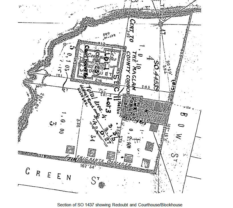
Ngati Maahanga: The Tainui canoe is said to have landed at various harbours along the North Island western coast with Tainui people disembarking at each location, including Whaingaroa also now known as Raglan. Ngati Maahanga is named from their ancestor, Maahanga, a prominent early Tainui leader. There is evidence of extensive early Maori activity and settlement around Raglan Harbour, the area having sustained Maori occupation until the arrival of European settlers. This is confirmed by numerous recorded archaeological sites ranging from pa to shell middens within Whaingaroa. Although there are no prehistoric archaeological sites recorded within the subject area, this does not preclude their existence. Whaingaroa came under direct Ngati Maahanga occupation in the early 1800s. Wiremu Nera Te Awaitaia was a highly regarded leader of Ngati Maahanga, a skilled fighter, who in the 1820s took Whaingaroa by raupatu (conquest) of Ngati Koata in a series of battles. Ngati Maahanga then claimed the land through ringa kaha (defence of the land), take tupuna (ancestral right) and raupatu (conquest). Te Awaitaia and European Settlement: In the 1830s Te Awaitaia came under the influence of Wesleyan missionary William White who set up mission stations along the coast including Kawhia and Whaingaroa. Te Awaitaia converted to Christianity in 1836 and developed a close relationship with Whaingaroa missionary James Wallis, even defending the mission station with his own people. Te Awaitaia is widely regarded by Ngati Maahanga as their first Maori Wesleyan minister as he travelled making peace and converting others to Christianity. An enthusiastic signatory to the Treaty of Waitangi in 1840, in March 1851 he and other rangatira sold the block of land at Whaingaroa on which Raglan township now stands. This early sale allowed European settlement in the area at an earlier stage than in most of the Waikato. Organised European settlement around the harbour began after this land sale and the port of Whaingaroa became a popular one for European traders, being considered a safe anchorage; this was crucial to the development of Raglan Township. The land in and around Wi Neera Street is in an area described as a native reserve when first surveyed in the 1850s; however no evidence or official designation of this status can be found. The land is thought to have been set aside for Te Awaitaia, who had a house located on the eastern side of Wi Neera Street. This was known as Naylor’s House and used as a meeting house by Ngati Maahanga. Kingitanga and the Waikato Phase of the New Zealand Wars: The early 1850s saw the establishment of Kingitanga or the King Movement throughout the central North Island. Many Waikato Maori were concerned at the rapid acquisition of land by the Colonial government and their loss of authority. It was believed that unifying Maori under a Maori King would put Maori on an equal footing with Europeans, reducing the potential for Government to capitalise on tribal divisions; also it was hoped through Kingitanga to restrain individual chiefs from selling land. The Colonial government perceived the establishment of Kingitanga as disloyalty to the British monarch and a threat to European settlement. Te Awaitaia was against Kingitanga, believing that it would provide a pretext for the crown to attack Maori. His support of the Crown did not extend to supporting their later invasion of the Waikato. He promoted peace and unity to both sides and, although opposed to Kingitanga, his high status and statesmanship made him widely respected amongst Maori throughout both the Waikato and New Zealand. A war by Taranaki Maori against the Crown started in 1860 and Governor Grey soon concluded that an invasion into Waikato would curtail Kingite support for the Taranaki war, with the advantage of opening up the Waikato for European settlement. In 1860 the estimated population of Raglan was 120 Europeans and 100 Maori. In April that year Native Secretary Donald McLean met with Te Awaitaia making arrangements for the defence of Raglan. He proposed ‘that a house should be erected for Wiremu Nero [Te Awaitaia] on a rising ground, the site of an old pa about the centre of the town, as a place of refuge in case of need, and that a Pa should be made by himself and his followers around the house…Your Excellency will cause half an acre of the said reserve to be made over to William Nero in fee simple as it is required for purposes of public safety.’ With the commencement of the Taranaki War, the Raglan settlers had become worried about their safety and began to organise their own defence. The settlers formed the Raglan Defence Committee and even fortified a brick house to act as a refuge. This was despite the fact that Te Awaitaia was publicly opposed to the King movement and had entered into an agreement with McLean for the defence of the town. A Government building was initiated in 1862 as a result of a request by local citizens. The Waikato War, which commenced in 1863, was one of the major campaigns of the New Zealand Wars, occurring about midway through the series of conflicts. The European force consisted of a mix of British soldiers and local militia volunteers recruited from colonists as a cost saving measure. This local militia was not highly trained, but had a vested interest in the outcome. A chain of redoubts and fortifications were erected from South Auckland to Waikato for the defence of Auckland. Although planned by Government, their construction was by local militia, except for Putoetoe Redoubt (Former). The popular view at the time was that settlements were vulnerable to attack at any moment. The government recognised that the settlers were fearful and in May 1863 provided a ship which evacuated forty four settlers, mostly women and children, to Auckland. Putoetoe Redoubt (Former) - Defending Raglan: At the same time as this ‘Raglan exodus’, the construction of the official defensible building in Raglan was well underway. The site for this building was on the western edge of Wi Neera Street, with views over the harbour. However a shortage of sawn timber and roofing materials for its construction slowed its completion. The building was intended to be used as a courthouse and jail, but is described in contemporary newspaper reports as a blockhouse, the court, the treasury and as the gaol. The construction of the single storey timber building seems to have been a government project undertaken with the assistance of the settlers and no direct military input. The assistance of Government Engineer and Surveyor Richard Todd was used in the construction of the building; contemporary newspaper reports state he was the architect. The construction of the defensible building continued through July 1863 and the roofing iron required to complete the building arrived from Auckland in August. Further defence works were also underway with the construction of a ditch and bank around the blockhouse. The work was carried out under the direction of Te Awaitaia’s nephew, Hetaraka Nero. As reported in an Auckland newspaper, the work on the entrenchments was undertaken by local Maori. “The natives, under the direction of Hereteraka Nero, are busy throwing up a redoubt. Our Maoris are throwing up an entrenchments, and our settlers are apathetic, and doing nothing.” Once completed, the settlers’ redoubt consisted of a single storey building of solid six inch Rimu, lined inside and weather-boarded, flanked by angles loop-holed for firing. The original design for the building called for iron-faced shutters so that the windows could be secured, however these were not available, so the windows were blocked up with loopholes for firing. It was noted that the building was ‘ball proof’ even against a rifle at close range. Despite the preparation of the defensible courthouse/blockhouse and surrounding redoubt there was still debate among the settlers as to the adequacy of the preparations. It was noted that the blockhouse would be very good for protecting townspeople, but was no larger than a good-sized farmhouse with standing room for approximately one hundred people. Te Awaitaia initially refused to allow Whaingaroa Harbour to be used for troop and supply movement; however later in 1863 he agreed that warships could anchor there. As the campaign in the Waikato War progressed, a detachment of troops was sent to Raglan to establish a secondary supply line into the Waikato from the Raglan harbour. This was part of an effort by General Cameron to provide extra supply routes to the front and to force Maori further south by flanking them using the coastal supply routes. Supplies and troops were not disembarked at the town centre, but some distance away at Waitetuna Stream Heads on Captain J.C. Johnstone’s property. These troops, under the command of Colonel Waddy, arrived in December 1863. At the time the blockhouse and redoubt were in existence, rifle pits were dug outside the redoubt; their exact location is not known. The troops constructed a second redoubt on Town Hill in Raglan to accommodate the military garrison and provide for the defence of the town. This redoubt was located on high ground at the north east end of Bow Street and is likely to be the redoubt drawn by Carberry. While Raglan was garrisoned by the military, the settler redoubt and blockhouse was used as a government store for munitions, but continued to function as the courthouse. Te Awaitaia died at Raglan on 27 April 1866. A monument in his memory was erected in front of his house, in 1870. His nephew, Hetaraka Nero succeeded him as leader. The military garrison left Raglan on 18th March 1867. Before leaving, they levelled the military redoubt located on Town Hill; a standard military practice to prevent the enemy utilising those defences. The settler redoubt with the defensible courthouse/blockhouse was apparently left intact. While the defensible courthouse/blockhouse continued to be used, the earthworks of the surrounding redoubt seem to have been neglected. With the military gone, the town was again under its own protection and the locals continued to worry that the town could be attacked by Maori. They began to petition the government to station Armed Constabulary in Raglan. The Government finally heeded the request and in late 1870 a detachment of Armed Constabulary went to Raglan. They did not stay long, but while there they did rebuild a smaller redoubt around the courthouse/blockhouse, and station three constables in the town to oversee its protection. The reconstructed redoubt differed from the original design and is described in contemporary newspapers, ‟…seems to be a very good piece of work. The soil being of a sandy description, it was found necessary to work in layers of tea-tree scrub; and this I think, will bind the embankment sufficiently. The new redoubt is some 20 feet smaller than the old one, and has only two flanking angles – at the south and north-west corners. It is about 6ft. 6in. high and has an elevation or step to fire from.” Later, on 11 November that same year, the Whaingaroa Wharf Committee petitioned the Superintendent of the Provincial Council “to set apart Section 11, Town of Raglan, as an endowment for wharf and harbour purposes for the said town”. The land is described as having a native hostelry and a blockhouse present on it. The request was speedily granted by the Superintendent of the Province of Auckland, Mr Thomas Gillies on 19 November 1870. The endowment was described by a local correspondent as being “a nest egg, from which we hope to raise a whole brood of maritime facilities.” The parcel was bounded by Bow Street, Green Street (now Wainui Road) and the harbour and divided in two by Wi Neera Street. Both the Courthouse/blockhouse and the hostelry were in poor repair, but crucially there was also disagreement about the ownership of the land in question. A paragraph in the Daily Southern Cross stated, “…Tenders have been called for painting and repairing the Court-house and native hostelry here. Both these buildings are situated on Section 11 which was granted by the Superintendent as a harbour endowment. It appears that no one is clear to whom this section belongs. Hetaraka Nero claims it as the property of the deceased Wiremu Nero, the Provincial Government, or rather the Harbour Trustees claim it, and the General Government claim it.” By 1877 the section was subdivided into three lots, Lot 1 containing the courthouse/blockhouse and redoubt, Lot 2 containing a small section on the east side of Wi Neera St for the Ngati Maahanga hostelry, and Lot 3 being the remainder. Lot 1 consisted of a small northern portion and a larger southern portion; the latter contained the courthouse/blockhouse but the redoubt’s earthworks were within both the northern and southern portions. There is a map of the subject area produced in 1877 showing the location of the courthouse/blockhouse building surrounded by the redoubt in relation to the property boundaries. In 1881 seven year leases were offered on Sections 1,2,3 and 4 of the Harbour Endowment. The date that the Armed Constabulary redoubt went out of use cannot be established; the site likely fell into disrepair over several years. This phase of the site history is shown in a historic photograph dated to 1887 which shows the courthouse/blockhouse building without surrounding earthworks, but before the construction of the house at 1 Wi Neera Street. However, the ditch and bank must have been levelled before 1892 as this is when the timber building at 1 Wi Neera Street was built over the northern portion of the redoubt. 1 Wi Neera Street House: 1 Wi Neera Street House (house) which is sited on the Putoetoe Redoubt (Former), at 1 Wi Neera Street, Raglan, dates from 1893 and is one of the earliest extant structures in Raglan in relatively original condition. The Waikato Times stated in its Raglan news that: “Mr Evans, contractor, from Hamilton, and his men are now busy erecting a new house on one of the lots of the Harbour Reserve situated near to the Court-house, for Messrs Langley. Constable Ryan is to be the occupier of the same when finished.” Arthur Langley (c 1851-1924) was an entrepreneur, who, with his brother had various businesses in Kawhia and Raglan from about 1883, including flax mills at Papanui and Kawhia, a general store, book shop and land commission agencies in Raglan and Kawhia. Arthur Langley was Kawhia agent for the Northern Steam Ship Company, Dalgety and Company and insurance companies. Arthur Langley was involved in community affairs including being chairman of the Kawhia Town Board in 1915. It is not known whether the Langleys ever lived in the house. Historical plans show that the house is situated on part of the site of the defensive ditch forming the redoubt around the courthouse/blockhouse. The house is situated on the west side of Wi Neera Street, facing east and when built was immediately adjacent and to the north of the courthouse/blockhouse. Few other small nineteenth century houses remain in Raglan, and most are greatly modified and do not retain their original appearance, unlike the house. Further development of the council land followed, the County Chambers was built on the eastern corner of Wi Neera Street and Bow Street, the Anglican Church was in a section facing Wainui Road [formerly Green Street] in an immigrant cottage, and at a later date, the post office next to the council chambers. Council leased the other sections, for a saw-mill and shops. The subject property, now called Lot 14, was leased from 19 April 1895 by Arthur Edward Langley. From 1902 the lease was briefly held by Benjamin Hamilton a store-keeper; who surrendered the lease a year later to L.D. Nathan and Co. Nathans held the lease on the Harbour View Hotel from 1894 and owned the hotel from 1901, likely using the house for staff accommodation. In October 1912, Isabel Smith took the lease of the house for a term of 21 years. William Smith was a builder, who, with his brother Alfred erected many local buildings. He was also an ironmonger; owner of a general store on the corner of Wi Neera and Bow Streets from 1906 and proprietor of the Raglan Butter Factory in 1910. The store, W.J. Smith’s or Smith’s Supply Stores, sold a wide variety of agricultural equipment, groceries, drapery, shoes and fuel; he also had a motor car available for tourists and used as a taxi. Smith’s was one of the two main stores in Raglan in the early twentieth century. Smith was also a Justice of the Peace and chairman of the second town board, elected in 1906. In 1920 the leases of the house and the store were transferred to the Farmers Union Trading Company. Farmers was a fast developing retail and manufacturing company which originated in Auckland, and by the end of 1920 had expanded to 29 stores throughout the upper North Island. The store’s managers lived in the cottage. Farmers retained the lease until 1956, after which several leases followed, until store closure in 1969. In 1993 the house was sold by Barbara Graham to the Waikato District Council, the successor to the Raglan County Council. It continued to be leased, first to several different doctors. It is currently used by the Raglan and District Museum Society for storage of the museum collection. Courthouse/Blockhouse and Police Station: The Putoetoe Redoubt (Former) has had a long association with law and order; the present day police station buildings are located on the redoubt. A Public Works statement of November 1903 states that the Raglan Courthouse ‘is past repair’. Tenders were called for by the Public Works Office in 1907 for construction of a Courthouse and a Police Station. Demolition of the Courthouse/Blockhouse began in June that same year. An early photograph shows the gable end of the new courthouse displaying the date of 1908. The courthouse is thought to have burned down circa 1960s. The police station was relocated to Robertson Road also in the 1960s. New station buildings were erected on the site during this decade and remain on site.
Ngati Maahanga: The Tainui canoe is said to have landed at various harbours along the North Island western coast with Tainui people disembarking at each location, including Whaingaroa also now known as Raglan. Ngati Maahanga is named from their ancestor, Maahanga, a prominent early Tainui leader. There is evidence of extensive early Maori activity and settlement around Raglan Harbour, the area having sustained Maori occupation until the arrival of European settlers. This is confirmed by numerous recorded archaeological sites ranging from pa to shell middens within Whaingaroa. Although there are no prehistoric archaeological sites recorded within the subject area, this does not preclude their existence. Whaingaroa came under direct Ngati Maahanga occupation in the early 1800s. Wiremu Nera Te Awaitaia was a highly regarded leader of Ngati Maahanga, a skilled fighter, who in the 1820s took Whaingaroa by raupatu (conquest) of Ngati Koata in a series of battles. Ngati Maahanga then claimed the land through ringa kaha (defence of the land), take tupuna (ancestral right) and raupatu (conquest). Te Awaitaia and European Settlement: In the 1830s Te Awaitaia came under the influence of Wesleyan missionary William White who set up mission stations along the coast including Kawhia and Whaingaroa. Te Awaitaia converted to Christianity in 1836 and developed a close relationship with Whaingaroa missionary James Wallis, even defending the mission station with his own people. Te Awaitaia is widely regarded by Ngati Maahanga as their first Maori Wesleyan minister as he travelled making peace and converting others to Christianity. An enthusiastic signatory to the Treaty of Waitangi in 1840, in March 1851 he and other rangatira sold the block of land at Whaingaroa on which Raglan township now stands. This early sale allowed European settlement in the area at an earlier stage than in most of the Waikato. Organised European settlement around the harbour began after this land sale and the port of Whaingaroa became a popular one for European traders, being considered a safe anchorage; this was crucial to the development of Raglan Township. The land in and around Wi Neera Street is in an area described as a native reserve when first surveyed in the 1850s; however no evidence or official designation of this status can be found. The land is thought to have been set aside for Te Awaitaia, who had a house located on the eastern side of Wi Neera Street. This was known as Naylor’s House and used as a meeting house by Ngati Maahanga. Kingitanga and the Waikato Phase of the New Zealand Wars: The early 1850s saw the establishment of Kingitanga or the King Movement throughout the central North Island. Many Waikato Maori were concerned at the rapid acquisition of land by the Colonial government and their loss of authority. It was believed that unifying Maori under a Maori King would put Maori on an equal footing with Europeans, reducing the potential for Government to capitalise on tribal divisions; also it was hoped through Kingitanga to restrain individual chiefs from selling land. The Colonial government perceived the establishment of Kingitanga as disloyalty to the British monarch and a threat to European settlement. Te Awaitaia was against Kingitanga, believing that it would provide a pretext for the crown to attack Maori. His support of the Crown did not extend to supporting their later invasion of the Waikato. He promoted peace and unity to both sides and, although opposed to Kingitanga, his high status and statesmanship made him widely respected amongst Maori throughout both the Waikato and New Zealand. A war by Taranaki Maori against the Crown started in 1860 and Governor Grey soon concluded that an invasion into Waikato would curtail Kingite support for the Taranaki war, with the advantage of opening up the Waikato for European settlement. In 1860 the estimated population of Raglan was 120 Europeans and 100 Maori. In April that year Native Secretary Donald McLean met with Te Awaitaia making arrangements for the defence of Raglan. He proposed ‘that a house should be erected for Wiremu Nero [Te Awaitaia] on a rising ground, the site of an old pa about the centre of the town, as a place of refuge in case of need, and that a Pa should be made by himself and his followers around the house…Your Excellency will cause half an acre of the said reserve to be made over to William Nero in fee simple as it is required for purposes of public safety.’ With the commencement of the Taranaki War, the Raglan settlers had become worried about their safety and began to organise their own defence. The settlers formed the Raglan Defence Committee and even fortified a brick house to act as a refuge. This was despite the fact that Te Awaitaia was publicly opposed to the King movement and had entered into an agreement with McLean for the defence of the town. A Government building was initiated in 1862 as a result of a request by local citizens. The Waikato War, which commenced in 1863, was one of the major campaigns of the New Zealand Wars, occurring about midway through the series of conflicts. The European force consisted of a mix of British soldiers and local militia volunteers recruited from colonists as a cost saving measure. This local militia was not highly trained, but had a vested interest in the outcome. A chain of redoubts and fortifications were erected from South Auckland to Waikato for the defence of Auckland. Although planned by Government, their construction was by local militia, except for Putoetoe Redoubt (Former). The popular view at the time was that settlements were vulnerable to attack at any moment. The government recognised that the settlers were fearful and in May 1863 provided a ship which evacuated forty four settlers, mostly women and children, to Auckland. Putoetoe Redoubt (Former) - Defending Raglan: At the same time as this ‘Raglan exodus’, the construction of the official defensible building in Raglan was well underway. The site for this building was on the western edge of Wi Neera Street, with views over the harbour. However a shortage of sawn timber and roofing materials for its construction slowed its completion. The building was intended to be used as a courthouse and jail, but is described in contemporary newspaper reports as a blockhouse, the court, the treasury and as the gaol. The construction of the single storey timber building seems to have been a government project undertaken with the assistance of the settlers and no direct military input. The assistance of Government Engineer and Surveyor Richard Todd was used in the construction of the building; contemporary newspaper reports state he was the architect. The construction of the defensible building continued through July 1863 and the roofing iron required to complete the building arrived from Auckland in August. Further defence works were also underway with the construction of a ditch and bank around the blockhouse. The work was carried out under the direction of Te Awaitaia’s nephew, Hetaraka Nero. As reported in an Auckland newspaper, the work on the entrenchments was undertaken by local Maori. “The natives, under the direction of Hereteraka Nero, are busy throwing up a redoubt. Our Maoris are throwing up an entrenchments, and our settlers are apathetic, and doing nothing.” Once completed, the settlers’ redoubt consisted of a single storey building of solid six inch Rimu, lined inside and weather-boarded, flanked by angles loop-holed for firing. The original design for the building called for iron-faced shutters so that the windows could be secured, however these were not available, so the windows were blocked up with loopholes for firing. It was noted that the building was ‘ball proof’ even against a rifle at close range. Despite the preparation of the defensible courthouse/blockhouse and surrounding redoubt there was still debate among the settlers as to the adequacy of the preparations. It was noted that the blockhouse would be very good for protecting townspeople, but was no larger than a good-sized farmhouse with standing room for approximately one hundred people. Te Awaitaia initially refused to allow Whaingaroa Harbour to be used for troop and supply movement; however later in 1863 he agreed that warships could anchor there. As the campaign in the Waikato War progressed, a detachment of troops was sent to Raglan to establish a secondary supply line into the Waikato from the Raglan harbour. This was part of an effort by General Cameron to provide extra supply routes to the front and to force Maori further south by flanking them using the coastal supply routes. Supplies and troops were not disembarked at the town centre, but some distance away at Waitetuna Stream Heads on Captain J.C. Johnstone’s property. These troops, under the command of Colonel Waddy, arrived in December 1863. At the time the blockhouse and redoubt were in existence, rifle pits were dug outside the redoubt; their exact location is not known. The troops constructed a second redoubt on Town Hill in Raglan to accommodate the military garrison and provide for the defence of the town. This redoubt was located on high ground at the north east end of Bow Street and is likely to be the redoubt drawn by Carberry. While Raglan was garrisoned by the military, the settler redoubt and blockhouse was used as a government store for munitions, but continued to function as the courthouse. Te Awaitaia died at Raglan on 27 April 1866. A monument in his memory was erected in front of his house, in 1870. His nephew, Hetaraka Nero succeeded him as leader. The military garrison left Raglan on 18th March 1867. Before leaving, they levelled the military redoubt located on Town Hill; a standard military practice to prevent the enemy utilising those defences. The settler redoubt with the defensible courthouse/blockhouse was apparently left intact. While the defensible courthouse/blockhouse continued to be used, the earthworks of the surrounding redoubt seem to have been neglected. With the military gone, the town was again under its own protection and the locals continued to worry that the town could be attacked by Maori. They began to petition the government to station Armed Constabulary in Raglan. The Government finally heeded the request and in late 1870 a detachment of Armed Constabulary went to Raglan. They did not stay long, but while there they did rebuild a smaller redoubt around the courthouse/blockhouse, and station three constables in the town to oversee its protection. The reconstructed redoubt differed from the original design and is described in contemporary newspapers, ‟…seems to be a very good piece of work. The soil being of a sandy description, it was found necessary to work in layers of tea-tree scrub; and this I think, will bind the embankment sufficiently. The new redoubt is some 20 feet smaller than the old one, and has only two flanking angles – at the south and north-west corners. It is about 6ft. 6in. high and has an elevation or step to fire from.” Later, on 11 November that same year, the Whaingaroa Wharf Committee petitioned the Superintendent of the Provincial Council “to set apart Section 11, Town of Raglan, as an endowment for wharf and harbour purposes for the said town”. The land is described as having a native hostelry and a blockhouse present on it. The request was speedily granted by the Superintendent of the Province of Auckland, Mr Thomas Gillies on 19 November 1870. The endowment was described by a local correspondent as being “a nest egg, from which we hope to raise a whole brood of maritime facilities.” The parcel was bounded by Bow Street, Green Street (now Wainui Road) and the harbour and divided in two by Wi Neera Street. Both the Courthouse/blockhouse and the hostelry were in poor repair, but crucially there was also disagreement about the ownership of the land in question. A paragraph in the Daily Southern Cross stated, “…Tenders have been called for painting and repairing the Court-house and native hostelry here. Both these buildings are situated on Section 11 which was granted by the Superintendent as a harbour endowment. It appears that no one is clear to whom this section belongs. Hetaraka Nero claims it as the property of the deceased Wiremu Nero, the Provincial Government, or rather the Harbour Trustees claim it, and the General Government claim it.” By 1877 the section was subdivided into three lots, Lot 1 containing the courthouse/blockhouse and redoubt, Lot 2 containing a small section on the east side of Wi Neera St for the Ngati Maahanga hostelry, and Lot 3 being the remainder. Lot 1 consisted of a small northern portion and a larger southern portion; the latter contained the courthouse/blockhouse but the redoubt’s earthworks were within both the northern and southern portions. There is a map of the subject area produced in 1877 showing the location of the courthouse/blockhouse building surrounded by the redoubt in relation to the property boundaries. In 1881 seven year leases were offered on Sections 1,2,3 and 4 of the Harbour Endowment. The date that the Armed Constabulary redoubt went out of use cannot be established; the site likely fell into disrepair over several years. This phase of the site history is shown in a historic photograph dated to 1887 which shows the courthouse/blockhouse building without surrounding earthworks, but before the construction of the house at 1 Wi Neera Street. However, the ditch and bank must have been levelled before 1892 as this is when the timber building at 1 Wi Neera Street was built over the northern portion of the redoubt. 1 Wi Neera Street House: 1 Wi Neera Street House (house) which is sited on the Putoetoe Redoubt (Former), at 1 Wi Neera Street, Raglan, dates from 1893 and is one of the earliest extant structures in Raglan in relatively original condition. The Waikato Times stated in its Raglan news that: “Mr Evans, contractor, from Hamilton, and his men are now busy erecting a new house on one of the lots of the Harbour Reserve situated near to the Court-house, for Messrs Langley. Constable Ryan is to be the occupier of the same when finished.” Arthur Langley (c 1851-1924) was an entrepreneur, who, with his brother had various businesses in Kawhia and Raglan from about 1883, including flax mills at Papanui and Kawhia, a general store, book shop and land commission agencies in Raglan and Kawhia. Arthur Langley was Kawhia agent for the Northern Steam Ship Company, Dalgety and Company and insurance companies. Arthur Langley was involved in community affairs including being chairman of the Kawhia Town Board in 1915. It is not known whether the Langleys ever lived in the house. Historical plans show that the house is situated on part of the site of the defensive ditch forming the redoubt around the courthouse/blockhouse. The house is situated on the west side of Wi Neera Street, facing east and when built was immediately adjacent and to the north of the courthouse/blockhouse. Few other small nineteenth century houses remain in Raglan, and most are greatly modified and do not retain their original appearance, unlike the house. Further development of the council land followed, the County Chambers was built on the eastern corner of Wi Neera Street and Bow Street, the Anglican Church was in a section facing Wainui Road [formerly Green Street] in an immigrant cottage, and at a later date, the post office next to the council chambers. Council leased the other sections, for a saw-mill and shops. The subject property, now called Lot 14, was leased from 19 April 1895 by Arthur Edward Langley. From 1902 the lease was briefly held by Benjamin Hamilton a store-keeper; who surrendered the lease a year later to L.D. Nathan and Co. Nathans held the lease on the Harbour View Hotel from 1894 and owned the hotel from 1901, likely using the house for staff accommodation. In October 1912, Isabel Smith took the lease of the house for a term of 21 years. William Smith was a builder, who, with his brother Alfred erected many local buildings. He was also an ironmonger; owner of a general store on the corner of Wi Neera and Bow Streets from 1906 and proprietor of the Raglan Butter Factory in 1910. The store, W.J. Smith’s or Smith’s Supply Stores, sold a wide variety of agricultural equipment, groceries, drapery, shoes and fuel; he also had a motor car available for tourists and used as a taxi. Smith’s was one of the two main stores in Raglan in the early twentieth century. Smith was also a Justice of the Peace and chairman of the second town board, elected in 1906. In 1920 the leases of the house and the store were transferred to the Farmers Union Trading Company. Farmers was a fast developing retail and manufacturing company which originated in Auckland, and by the end of 1920 had expanded to 29 stores throughout the upper North Island. The store’s managers lived in the cottage. Farmers retained the lease until 1956, after which several leases followed, until store closure in 1969. In 1993 the house was sold by Barbara Graham to the Waikato District Council, the successor to the Raglan County Council. It continued to be leased, first to several different doctors. It is currently used by the Raglan and District Museum Society for storage of the museum collection. Courthouse/Blockhouse and Police Station: The Putoetoe Redoubt (Former) has had a long association with law and order; the present day police station buildings are located on the redoubt. A Public Works statement of November 1903 states that the Raglan Courthouse ‘is past repair’. Tenders were called for by the Public Works Office in 1907 for construction of a Courthouse and a Police Station. Demolition of the Courthouse/Blockhouse began in June that same year. An early photograph shows the gable end of the new courthouse displaying the date of 1908. The courthouse is thought to have burned down circa 1960s. The police station was relocated to Robertson Road also in the 1960s. New station buildings were erected on the site during this decade and remain on site.
Construction Professionals: Redoubt: Hetaraka Nero (? – 1873) House: Thomas Evans (1844-?) Current Description: The site of the redoubt and courthouse/blockhouse at Raglan was first recorded as an archaeological site in September 2004 by Owen Wilkes and given the NZAA site record number R14/341. At the time of its recording the site was occupied by the Raglan police station, associated buildings and a timber house located at 1 Wi Neera Street, Raglan. The NZAA site record, entered in 2004, states that there were no traces of the redoubt visible on the ground surface; however during a site visit carried out by NZHPT on the 19th January 2012 traces of earthworks surviving across the northern portion of the site were visible. There is a distinct rise across the centre of the redoubt site in the area that would have been occupied by the courthouse/blockhouse and a hollow that runs across the back garden of the house is likely to represent a portion of the western ditch of the redoubt. The construction of the buildings, in particular the police station, is likely to have modified the archaeological site, but it is likely that there will still be intact archaeological features and deposits surviving below ground across the subject area. No archaeological excavations have been carried out within the subject area, or in its immediate vicinity, to quantify exactly what material does survive in-situ. Despite the lack of visible archaeological evidence on the surface of the site there is sufficient documentary evidence relating to the site to be certain about the location and history of the redoubt and to outline its development over time. The house was built in 1893 as a simple four roomed cottage, square in plan except for a stepped out portion on the north elevation which provided more space for the drawing room, and a small lean-to at the rear (west elevation). There was a verandah across the front, facing east to Wi Neera Street; the verandah had a return onto the north side, partially filling in the gap made by the projecting part of this elevation. The house had a hipped roof, U shaped in plan view, with the northern hip being wider to accommodate the drawing room beneath. The house was wooden framed, clad with plain profile weatherboards and a corrugated iron roof. A picket fence enclosed the house and grounds. There was possibly only one chimney, serving the two southern rooms, though there may have been another in the lean-to. The house is now a simple wooden building clad with plain profile weatherboards, with corrugated iron roof, a wooden verandah across the front accessed by concrete steps and a wooden ramp, and a small concrete terrace (porch) at the rear. The house faces east to Wi Neera Street which is a narrow no exit street, perpendicular to the main shopping street of Raglan. The police station and house are close by to the south. The house sits on a 1239 square metre (1 rood 9 perches) enclosed section, at the rear of which is a steep bank down to the harbour’s edge.
Construction Professionals: Redoubt: Hetaraka Nero (? – 1873) House: Thomas Evans (1844-?) Current Description: The site of the redoubt and courthouse/blockhouse at Raglan was first recorded as an archaeological site in September 2004 by Owen Wilkes and given the NZAA site record number R14/341. At the time of its recording the site was occupied by the Raglan police station, associated buildings and a timber house located at 1 Wi Neera Street, Raglan. The NZAA site record, entered in 2004, states that there were no traces of the redoubt visible on the ground surface; however during a site visit carried out by NZHPT on the 19th January 2012 traces of earthworks surviving across the northern portion of the site were visible. There is a distinct rise across the centre of the redoubt site in the area that would have been occupied by the courthouse/blockhouse and a hollow that runs across the back garden of the house is likely to represent a portion of the western ditch of the redoubt. The construction of the buildings, in particular the police station, is likely to have modified the archaeological site, but it is likely that there will still be intact archaeological features and deposits surviving below ground across the subject area. No archaeological excavations have been carried out within the subject area, or in its immediate vicinity, to quantify exactly what material does survive in-situ. Despite the lack of visible archaeological evidence on the surface of the site there is sufficient documentary evidence relating to the site to be certain about the location and history of the redoubt and to outline its development over time. The house was built in 1893 as a simple four roomed cottage, square in plan except for a stepped out portion on the north elevation which provided more space for the drawing room, and a small lean-to at the rear (west elevation). There was a verandah across the front, facing east to Wi Neera Street; the verandah had a return onto the north side, partially filling in the gap made by the projecting part of this elevation. The house had a hipped roof, U shaped in plan view, with the northern hip being wider to accommodate the drawing room beneath. The house was wooden framed, clad with plain profile weatherboards and a corrugated iron roof. A picket fence enclosed the house and grounds. There was possibly only one chimney, serving the two southern rooms, though there may have been another in the lean-to. The house is now a simple wooden building clad with plain profile weatherboards, with corrugated iron roof, a wooden verandah across the front accessed by concrete steps and a wooden ramp, and a small concrete terrace (porch) at the rear. The house faces east to Wi Neera Street which is a narrow no exit street, perpendicular to the main shopping street of Raglan. The police station and house are close by to the south. The house sits on a 1239 square metre (1 rood 9 perches) enclosed section, at the rear of which is a steep bank down to the harbour’s edge.
Historical and Associated Iwi / Hapū / Whānau
Public NZAA Number
R14/341
Completion Date
14th June 2013
Report Written By
W. Maguire; L. Williams; G. Henry; L. Pattison
Information Sources
Dictionary of New Zealand Biography
Dictionary of New Zealand Biography
Wises Post Office Directories
Wises Post Office Directories
Laurenson, 2005
Helen B Laurenson, Going Up, Going Down: the Rise and Fall of the Department Store, Auckland University Press, Auckland, 2005.
Ritchie, 2001
Neville Ritchie, The Waikato War of 1863-64: A Guide to the Main Events and Sites, Te Awamutu, 2001
Stowers, 1996
Stowers, Richard, Forest Rangers: A History of the Forest Rangers During the New Zealand Wars, R. Stowers, 1996
Vennell, 1976
C W Vennell & Susan Williams Raglan County hills and sea; a centennial history 1876-1976 Wilson & Horton Ltd, Auckland 1976.
Bradbury, 1915 (2)
E Bradbury, Raglan and Kawhia District, New Zealand, E.E. Bradbury, Auckland, 1915,
Smith, 1910 (4)
Smith, S., Percy, History and Traditions of the Maoris of the West Coast North Island of New Zealand Prior to 1840, ‘Te Kuititanga 1839’, Polynesian Society, 1910
Smith, 1910 (4)
Smith, S., Percy, History and Traditions of the Maoris of the West Coast North Island of New Zealand Prior to 1840, ‘Te Kuititanga 1839’, Polynesian Society, 1910
Other Information
A fully referenced report is available from the Lower Northern Area Office of NZHPT. Please note that entry on the New Zealand Heritage List/Rarangi Korero identifies only the heritage values of the property concerned, and should not be construed as advice on the state of the property, or as a comment of its soundness or safety, including in regard to earthquake risk, safety in the event of fire, or insanitary conditions.
Current Usages
Uses: Civic Facilities
Specific Usage: Museum
Uses: Law Enforcement
Specific Usage: Police station
Former Usages
General Usage: Accommodation
Specific Usage: House
General Usage: Defence
Specific Usage: Blockhouse
General Usage: Defence
Specific Usage: Fortification
General Usage: Defence
Specific Usage: Redoubt
General Usage: Health
Specific Usage: Doctor’s Surgery
General Usage: Law Enforcement
Specific Usage: Courthouse
General Usage: Law Enforcement
Specific Usage: Gaol/Lock-up
General Usage: Law Enforcement
Specific Usage: Police station
Themes
Of Significance to Maori
New Zealand Wars
Location
Stay up to date with Heritage this month
