

The Tamaki River formed an important waterway for both Maori and later settlers. In 1848, a colonial settlement of military ‘fencible’ type was established beside the river at Panmure - one of several created by the colonial authorities to protect Auckland’s southern flank. These settlements have been regarded as representing the first use of the ‘enrolled pensioner’ system in the British colonies. In the early 1860s, the Auckland Provincial Council decided to erect a bridge to improve connections between Panmure and another of the fencible settlements, at Howick.
Initial drawings were prepared by the colony’s Chief Superintendent of Roads and Bridges, W. R. Collett (1810-82). Plans were at least partly adapted by the Provincial Engineer-in-Chief, William Weaver (1828-68), who oversaw construction and was later given credit for the bridge design. Both men had previously held official positions in New South Wales, Weaver serving as Colonial Architect. Other Australian connections were strong: the successful contractors, Wilson and O’Neill, were from Victoria; the swing span mechanism was made by P.N. Russell and Company of Sydney; and basalt blocks for the abutments came from the Melbourne area. Timber materials, however, such as totara piles and kauri decking were more locally sourced.
The main works started in October 1864 and were mostly complete by October 1865, when the final cornerstone was ceremonially laid by Robert Graham (1820-85), the Provincial Superintendent responsible for commissioning the bridge. The first traffic crossed the structure in December, although final work wasn’t finished until March 1866. Tolls to cover construction costs were collected from an associated toll house, which also serving as a polling booth during provincial and national elections. Initially only opened during daytime hours, the swing span later became operational at night so that the shipment of goods along the Tamaki to and from Otahuhu remained fully unimpeded.
The bridge became a meeting place for groups that included the Pakuranga Hunt. The structure was taken over by central government in 1876, and by the Pakuranga Road Board in 1889. In 1916, the bridge was closed and its timber elements demolished, although the swing span mechanism and its associated stone abutment were retained. Prior to 1986, a building was erected on piles over the top of the remnants. In 2013, the swing span mechanism was extensively conserved.
List Entry Information
Status
Listed
List Entry Status
Historic Place Category 2
Access
Private/No Public Access
List Number
9501
Date Entered
26th June 2014
Date of Effect
26th June 2014
City/District Council
Auckland Council
Region
Auckland Council
Extent of List Entry
Extent includes the land described as Secs 1 and 3 SO 66069 (RTs NA102D/7, NA 99C/463, NZ Gazette 1994, p.917) and part Tamaki River, and the structure known as the Panmure Bridge Swing Span and Abutment thereon. Extent excludes a modern building, erected on piles over the bridge structure (Refer to map in Appendix 1 of the registration report for further information).
Legal description
Secs 1 and 3 SO 66069 (RTs NA102D/7, NA 99C/463, NZ Gazette 1994, p.917) and part Tamaki River, North Auckland Land District
Why is this place significant?
Historic Significance
Historical Significance or Value The place has historical significance for its associations with settler expansion to the south of the colonial capital at Auckland, at the time of the third New Zealand - or Waikato - War (1863-4). Construction of the bridge stimulated the economic development of lands to the east of the Tamaki, as government authorities strengthened their control over territories beyond the Bombay Hills. The place reflects the importance of improved communications in the economic development of early colonial New Zealand. It particularly demonstrates the requirement to accommodate waterborne transport as overland networks were developed. It reflects the role of Provincial Government in creating such infrastructure during the early colonial period. The place has particular connections with the major programme of works carried by Auckland’s Provincial Council in the early- and mid-1860s, which also served to enhance the provincial government’s leadership and status. The place is historically significant for its connections with several notable individuals, including the Provincial Superintendent, Robert Graham; New Zealand’s Superintendent of Road and Bridges, W.R. Collett; Auckland Province’s Engineer-in Chief, William Weaver; and the builder Henry O’Neill, who went on to erect Wanganui Swing Bridge. The place demonstrates the strength of trade and other links with Australia at this time in the history of the Auckland region. The place is important as one of few built remnants linked with the early colonial settlement at Panmure - significant as one of a small number of ‘fencible’ pensioner settlements created during the initial colonisation of New Zealand. These settlements formed part of a new strategy by Great Britain to both aid colonisation and reduce expenditure on military pensions. The New Zealand settlements have been regarded as representing the first use of the ‘enrolled pensioner’ system in the British colonies, which was subsequently employed in Australia, Canada and the Falkland Isles.
Physical Significance
Technological Significance or Value The place has high technological significance for incorporating the well-preserved remnants of the earliest surviving swing span bridge mechanism in New Zealand. Associated with other remaining elements, notably parts of an associated swing span superstructure and stone abutments, the mechanism demonstrates the adoption of imported technology, expertise and materials from other parts of the British Empire, notably Australia. The mechanism is the only surviving example of its type from the first phase of major swing span bridge construction in New Zealand, when similar structures were erected at Kaiapoi (1863), Heathcote (1864) and Wanganui (1869-71). Technological significance extends to methods of construction. The stone abutments contain evidence of quarrying and construction technology.
Why is this place Category 1 / Category 2?
Detail Of Assessed Criteria
(a) The extent to which the place reflects important or representative aspects of New Zealand history The place reflects the importance of transport networks in the economic development of early colonial New Zealand. The place particularly demonstrates the requirement to accommodate waterborne transport as road networks were improved. The place is one of few visible remnants of the early colonial township at Panmure, which was created in 1848 as a ‘fencible’ settlement occupied by military pensioners. The bridge, linking Panmure and the nearby fencible settlement at Howick, demonstrates the importance of communications between different settlements within this network. The New Zealand settlements have been regarded as representing the first use of the ‘enrolled pensioner’ system in the British colonies. Creation of the bridge reflects attempts to consolidate these settlements by improving their supporting infrastructure. The Panmure Bridge Swing Span and Abutment strongly demonstrates links between Auckland province and Australia at the time of the third New Zealand - or Waikato - War (1863-4). The bridge was designed, engineered and built using expertise from the Australian colonies. The surviving remnants also demonstrate the importation of Australian products and materials. The latter include machinery manufactured by P.N. Russell and Company of Sydney, and pre-shaped basalt from Victoria. (b) The association of the place with events, persons, or ideas of importance in New Zealand history The Panmure Bridge Swing Span and Abutment is closely associated with the region’s ruling body between 1853 and 1876, the Auckland Provincial Council. The Council controlled the largest of New Zealand’s six initial provinces. Provincial authorities raised money for creation of the bridge; commissioned its construction; and oversaw its initial use. The bridge also has associations with later administrative bodies, including the Papakura Road Board between 1889 and 1916. The place also has strong connections with several notable individuals, including the Provincial Superintendent, Robert Graham; Auckland Province’s Engineer-in-Chief and a former Colonial Architect of New South Wales, William Weaver; and the builder Henry O’Neill, who went on to erect Wanganui Swing Bridge. New Zealand’s Superintendent of Road and Bridges, and a former British Member of Parliament, W.R. Collett, provided an initial design. The place has associations with local groups such as the Pakuranga Hunt Club, which met at the bridge over many years. (c) The potential of the place to provide knowledge of New Zealand history The place has potential to provide knowledge of New Zealand’s engineering history through detailed study of the bridge’s swing mechanism and other physical remains. Such investigation has the potential to yield knowledge about the installation, operation and maintenance of early colonial swing bridge mechanisms. It may also yield evidence about the manufacture of equipment and construction materials overseas. (f) The potential of the place for public education Located on publicly-owned land beside a major arterial route, and associated with a heritage trail that encompasses other place and structures linked with the history of road and waterborne transport associated with the Tamaki, the place can be regarded as having considerable potential for public education. (g) The technical accomplishment or value, or design of the place The place has high significance for incorporating the well-preserved remnants of the earliest surviving swing bridge mechanism in New Zealand, and the most technologically important parts of the earliest major swing bridge to have been erected in the North Island. (i) The importance of identifying historic places known to date from early periods of New Zealand settlement The place dates to an early period in the formal colonisation of New Zealand, when Auckland was colonial capital. (j) The importance of identifying rare types of historic places The place has high significance as a rare surviving example of swing bridge technology in New Zealand. Comparatively few known examples of swing bridge mechanisms from the nineteenth and early twentieth centuries are known to survive. The place contains the only currently-known example of a swing bridge mechanism to survive from the first major phase of swing bridge construction in New Zealand. (k) The extent to which the place forms part of a wider historical and cultural complex or historical and cultural landscape The place forms part of a wider historical and cultural landscape linked with water and road transportation, which includes the Tamaki River; an early colonial ferry crossing; ferro-concrete remnants of the 1916 bridge; a concrete wharf erected by American troops during the Second World War, and a more recent bridge structure. Extensive use of the Tamaki by Maori led to widespread occupation of its banks, including Mokoia pa, on the west bank of the River opposite the swing span mechanism and stone abutment.
Construction Professional
Name
Collett, W.R.
Type
Designer
Biography
William Rickford Collett (1810-82) was born in Hemel Hempstead, England. He was the Member of Parliament for Lincoln between 1841 and 1847, and is reported as having experience in English railways. After moving to New South Wales in the late 1840s or early 1850s, Collett became a director of the Australian Mutual Mining Association. In 1854, he was appointed Government Surveyor for the Northern Road from Morpeth to the Gap at Murrurundi. When he opened the Arnold Bridge over the River Page at Murrurundi in 1861, he was described as New South Wales’ Commissioner for Roads. In March 1864, Collett became New Zealand’s Chief Superintendent of Roads and Bridges. One of his first tasks was to construct a railway line from Maungatawhiri to Meremere, for which he used imported labour from Australia. At a similar time, he prepared the design for a swing span bridge across the Tamaki River at Panmure. He was subsequently involved in a government-funded scheme to explore the coal fields at Kawakawa. Suffering financial difficulties, Collett was declared insolvent in Sydney in 1866. This was partly due to the foreclosure of a mortgage on a gold mining venture, which he had started in 1862 at Denison, New South Wales. He subsequently returned to the British Isles, unsuccessfully contesting a seat in Ireland for the Conservative Party in 1868. Collett died in 1882, and was buried at Deans Grange Cemetery, Dublin. Source: Registration Report for Panmure Swing Span and Abutment (Register No. 9501), May 2014
Name
Weaver, William
Type
Engineer
Biography
William Weaver (1828-68) was born and educated in England, where he trained as a civil engineer. A pupil of the renowned Isambard Kingdom Brunel from 1846, he also trained under R.J. Ward, M.M.Inst.C.E. Weaver gained experience on the Great Western Railway and in coal mining before departing for Australia in 1850. In Sydney, he was employed as a foreman and then Clerk of Works under the Colonial Architect, Edmund Blacket. Weaver was credited with much of the design for the Victoria Bridge, Maitland, which incorporated new approaches to timber-truss bridge construction introduced from England. Between 1854 and 1856, Weaver held the post of Colonial Architect in New South Wales. Weaver’s projects during this period included the construction of a new Government Printing Office in Sydney and the erection of numerous timber bridges in rural districts. After resigning, he undertook private work as part of the partnership of Weaver and Kemp, including construction of the Robey Sugar Company refinery and spirit distillery on Sydney’s North Shore (1858). In 1863, it was said that his pier at the Bulli Coal Company’s mine was one of the most important works, either public or private, that had yet been constructed in connection with coal mining enterprise in New South Wales. In 1864, Weaver moved to New Zealand to take up the position of Engineer-in-Chief to Auckland Province. He laid on Auckland’s first piped water supply, sourced from Auckland Domain, and prepared plans for significant improvements to assist shipping on both the Waitemata and Manukau harbours. In 1864-5, Weaver supervised the erection of a swing span bridge over the Tamaki River at Panmure; and in 1867 took over control of telegraph communications from the military authorities. In early 1868, he was appointed Telegraph Engineer for New Zealand. Weaver died at Geelong, Victoria in December 1868. Source: Registration Report for Panmure Bridge Swing Span and Abutment (Register No. 9501), May 2014
Name
McNeill and Wilson
Type
Builder
Biography
No biography is currently available for this construction professional
Construction Details
Start Year
1883
Type
Maintenance/repairs
Description
Repairs to swing span mechanism
Start Year
1916
Type
Partial Demolition
Description
Demolition of timber parts of bridge - swing span mechanism and stone abutment on east bank retained
Type
Additional building added to site
Description
Construction of building above bridge remnants
Period
Pre-1986
Start Year
2013
Type
Restoration
Description
Conservation of swing span mechanism
Start Year
1864
Finish Year
1865
Type
Original Construction
Construction Materials
Basalt abutments; and iron and timber turntable; iron superstructure and winding mechanism.
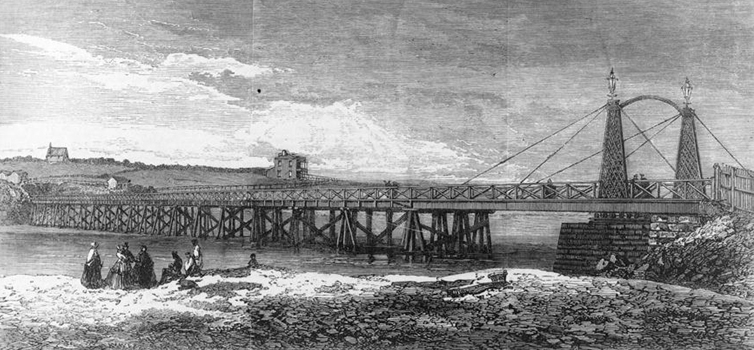
Early history of the site The Tamaki River has traditionally been an important waterway for Maori, connecting the Waitemata and Manukau harbours via a short portage. Inhabitants of the area have included Ngai Tai, descendants of migrants from the Tainui canoe that once traversed this route. During the seventeenth and early eighteenth centuries, the Tamaki Isthmus and surrounding districts were controlled by a confederation of Tainui peoples known as Waiohua, which included Ngai Tai. Perhaps in the late seventeenth century the Ngati Whatua leader, Kawharu, attacked settlements beside the Tamaki River, and also Ngai Tai strongholds further east. According to historian Russell Stone, Ngati Paoa had settled on the east side of the river by the late eighteenth century and also occupied a smaller area on the west, probably near modern Panmure. A Ngati Paoa stronghold at Mokoia pa was situated at the mouth of Panmure Basin, controlling access to this tidal lagoon and also overlooking a relatively narrow stretch of the river. In the early nineteenth century, European visitors commented on the density of occupation and extent of cultivation in the area. In 1821, Mokoia and its associated trading station at Mauinaina were attacked by Ngapuhi under Hongi Hika. Although a few defenders escaped from Mokioa by swimming to the east bank of the Tamaki, both settlements were rendered tapu by the number of people killed and subsequently abandoned. A signing of the Treaty of Waitangi, New Zealand’s founding document, took place north of Mokoia, at Karaka Bay, in March 1840. In 1848, a colonial township was established beside the basin at Panmure as part of a network of military ‘Fencible’ settlements to the south of the colonial capital at Auckland. Four towns, comprising Onehunga, Otahuhu, Panmure and another at Howick to the east of the Tamaki, were settled by military pensioners from Britain. A fifth township, at Mangere, was occupied by local Maori. Collectively, these settlements were intended to protect Auckland from possible attack by Maori forces opposed to government authority, but can also be seen as a part of a colonial strategy to economically develop the southern part of the isthmus and enhance Auckland’s role as an entrepot. The pensioner settlements formed part of a new strategy used by Great Britain to both aid colonisation and reduce expenditure on military pensions. The New Zealand settlements have been regarded as representing the first use of the ‘enrolled pensioner’ system in the British colonies, which was subsequently employed in Australia, Canada and the Falkland Isles. Preparations for creation of the Panmure Swing Span Bridge Physical communication between the new townships was vital for their survival and growth. Waterborne transport connecting Panmure to other settlements included regular cutter services launched from Auckland in 1848. In 1852, the first steamer built in New Zealand, the Governor Wynyard, travelled to Panmure on its maiden voyage, having been expressly designed for ‘the Tamaki trade’. The Tamaki River remained an important trading route for settlements on its banks in ensuing years, being considered one of the busiest waterways in New Zealand in the late 1850s. Overland transport was initially rudimentary. Road travel between Panmure and the outlying township at Howick, for example, involved crossing the Tamaki by punt. The government-maintained boat was slow and occasionally laid up for repair. Delays were also caused by the transportation of large quantities of stock. In 1853, a suspension bridge was mooted as a replacement. Four years later, a public meeting at Howick discussed ways of having a bridge erected. In January 1862, Auckland’s Provincial Council agreed to draw up an estimate for the cost of a ‘substantial Bridge’. A competition was held for a structure that would not interfere with navigation, leading to the choice of a site spanning the Tamaki beside the entrance to Panmure Basin. The Tamaki Bridge Act, passed in February 1864, allowed the Provincial Superintendent to raise up to £15,000 for bridge construction. The structure was to be part of a much larger programme of public works authorised by the Auckland Loan Act 1863 to enhance the province’s prosperity and status. As well as a bridge at Panmure, works were to include improvements to Auckland harbour and other infrastructure, construction of the Whau Lunatic Asylum, a new Post Office and Customhouse, and a Supreme Court. The main beneficiaries of a new bridge were settlers who lived or had interests on the east side of the Tamaki, although some in Panmure also stood to gain. Major businessmen such as James Williamson testified to the advantages of a new structure when the Provincial Council, itself dominated by Auckland’s commercial leaders, made decisions about construction. One of those who stood to especially profit was the auctioneer and businessman Alfred Buckland, who owned a nearby stock landing. At this time, the east bank of the Tamaki was the main landing place for cattle from the East Coast making its way to the Auckland market. More generally, the improvement of access across the Tamaki occurred in the context of settler expansion to the south of Auckland, including government invasion of Maori lands during the third New Zealand - or Waikato - War (1863-4). A design for the bridge was obtained from William Rickford Collett (1810-82), recently appointed as New Zealand’s Chief Superintendent of Roads and Bridges. Collett had previously been a Member of the British Parliament, before serving as Government Surveyor for the Northern Road in New South Wales in the 1850s and that same colony’s Commissioner for Roads in 1861. Another new appointee from Australia, William Weaver (1828-68), was later credited with the bridge design, having overseen its organisation and construction after his appointment as Engineer-in-Chief to Auckland Province in early 1864. Weaver’s professional life had parallels with Colletts’, having trained in England under Isambard Kingdom Brunel before obtaining the post of Colonial Architect in New South Wales in 1854. He subsequently undertook private work in Australia before taking responsibility for the ambitious programme of works run by Auckland Province in the mid-1860s, and was later to become Telegraph Engineer for New Zealand. Weaver prepared a model of the Panmure bridge, which was exhibited at the 1865 New Zealand Industrial Exhibition. The bridge’s swing span design was comparatively new in a New Zealand context, occurring immediately after the first large-scale examples had been commissioned and erected by the Canterbury Provincial Government at Kaiapoi (1863) and Heathcote (1864). Swing span bridges formed an important technology in the early days of improved land transport, when waterborne trade and communication was still the prevailing mode. They were to become the most common type of movable bridge in New Zealand, enabling waterborne and road (or rail) transport to be simultaneously accommodated. Construction of the Panmure Swing Span Bridge (1864-5) Construction of the Panmure Bridge appears to have been more complex than its Canterbury forerunners and, at an eventual cost of £17,025, significantly more expensive. The bridge was planned to be at least 720 feet long (including its abutments) and, other than its iron swing span and stone abutments, was constructed of timber. Unlike the Canterbury bridges, the swing-span was to swivel from the east abutment rather than a pier in the centre of the river. Tenders for construction were advertised in April 1864. The winning contractors were McNeill and Wilson, from Victoria. Henry McNeill (?1831-1889), who managed the project, was later to erect the Wanganui Swing Bridge (1869-71) and other structures in the Manawatu. Work on the Panmure bridge started in early October 1864. Initial difficulties were encountered both during the driving of totara piles and construction of abutments. The local geology required piles of an unanticipated length, driven up to eighteen feet into the river bed. Damage to copper sheathing caused during this process also necessitated repairs by specialist divers from Cape Colony, who used up-to-date equipment - Heinke’s Patent Diving Apparatus, recently employed for construction of Westminster Bridge, London - to work underwater. Efforts to find local stone for abutment construction also had to be given up, requiring the importation of basalt blocks from Melbourne, dressed and numbered ready for erection. A coffer dam was erected around the east abutment, with blocks hoisted into place by a travelling crane. The iron swing span section was promoted as ‘one of the most perfect mechanical contrivances of the kind in the Southern hemisphere’. Continuing the strong Australian connections of the bridge’s construction, it was commissioned from Messrs. P.N. Russell and Company of Sydney at a cost of over £3000. P.N. Russell were one of the largest engineering works in Australia and had previously provided equipment for one of designer William Collett’s mining ventures in New South Wales. The opening for the swing bridge mechanism was in place by May 1865. The final cornerstone was laid by the businessman and politician, Robert Graham (1820-85), at a ceremony in October 1865. Graham was the member of the House of Representatives for Franklin, and had just stepped down as Provincial Superintendent, having seen many of the public works and buildings started during his tenure come to fruition. The bridge was used by the public for the first time to allow attendance at the Howick Races on Boxing Day 1865. However, work on the approaches was not completed until March 1866. An early accident involving a horse-drawn vehicle resulted in the death of its driver, Thomas Beake (also reported as William Peek), said to have been one of the oldest omnibus drivers in the colony. Completion of the bridge stimulated economic development of the area. Impacts included the launch of a daily return omnibus trip between Auckland and Howick. The cost of the bridge was to be recouped from tolls. These were reduced for foot passengers and stock after representations from powerful individuals including Alfred Buckland, who regularly transported flocks of 500-1000 sheep across the river. The swing bridge was initially obliged to be opened for vessels whenever required between sunrise and sunset. The collection of tolls was advertised for tender to private parties. In 1866, they were purchased by John Scarrott at the rate of £400 per year. A wooden toll house of Gothic design was erected beside the swing mechanism on the east bank. In October 1867, an illustration of the bridge appeared in the London Illustrated News. Subsequent use and modification The bridge attracted a variety of activities from soon after its opening. In early 1866, the toll house was appointed an official polling place for elections to the House of Representatives, and also nominations for representatives to serve Franklin District. Both positions were held by the bridge’s promoter, Robert Graham. The bridge was sometimes used as a meeting place. In 1867, about 300 schoolchildren from Panmure and Howick gathered at the structure before processing to the opening of a new Catholic Hall in Panmure. The Auckland Garrison Hunt also met at, or near the bridge. The Pakuranga Hunt Club similarly advertised to gather at the Panmure Bridge from at least 1875, and was still meeting there in 1913. Night opening of the swing span was allowed from 1867 on the payment of 5s per vessel. This reflected the importance of ongoing trade on the Tamaki to settlement further up the river, notably at Otahuhu. In the mid-1870s, Otahuhu was declared to be the largest agricultural settlement in Auckland Province. Farmers used the river to transport wheat, chaff and farm produce. Waterborne trade may have declined after Otahuhu was connected to Auckland by rail in 1875. Initial repairs to the bridge appear to have been undertaken in 1872. After abolition of Provincial government in 1876, control of the bridge was transferred to central government. In 1879, further repairs were carried out, at which time the swing mechanism was closed. A report in 1882 identified that the turntable of the swing mechanism was ‘very much out of order’, and would require thorough overhauling and substantial repair. Repairs to the value of £515 were carried out between April and June 1883 by the contractor J.J. O’Brien. During the economic depression of the 1880s, the government became embroiled in a dispute with the local Road Board about responsibility for the bridge. The Board refused to take control until extensive repairs had been undertaken. In December 1887, the services of the existing bridge caretaker were dispensed with, leading to problems for people crossing the river when no replacement was installed. A tender for further repairs to the bridge was tendered in 1888. That for £158 from E. Mills was accepted. In 1889, the bridge was vested in the Pakuranga Road Board. Nearby Road Boards on either side of the Tamaki were also required to contribute towards its upkeep. The bridge accommodated new forms of transport as they arose. Early bicycle races from Panmure to Parnell began at the bridge in 1889 and 1890. The bridge also featured in military practices or manoeuvres, including during the Russian Scare of 1885 and a visit to Auckland by Lord Kitchener in 1910. The bridge was evidently deteriorating when an engineer was despatched to report on its condition in 1895. The structure was estimated to cost £1675 to repair and £3500 to replace. Repair work was carried out in 1897-8. Totara and kauri sold at the bridge by the Road Boards may represent an attempt to sell replaced timber as a way of defraying costs. Similar sales in 1899 and 1901 could suggest on-going work. The bridge decking was tarred and sanded in 1900. By-laws in 1898 required that all those crossing the bridge should proceed at walking pace. Further by-laws in 1903 outlawed fishing and riding bicycles across the bridge. By this time, the Tamaki was no longer as important for commercial waterborne traffic. When a new bridge was mooted in 1913, it was stated that few vessels went further upstream than Panmure. Demolition of the timber superstructure (1916) Much of the bridge was demolished when a new ferro-concrete structure was erected a short distance downstream. The replacement structure was opened by the Prime Minister, W.F. Massey, in August 1916. At the opening ceremony, reference was made to the history of the earlier bridge and its contribution to the development of the region. Tenders for purchase of the timber parts of the 1864-5 structure had been advertised in April 1916. Removal was to occur after the new bridge had been opened for traffic. Significant parts of the old bridge were left in place on the east bank, notably those elements connected with the swing span mechanism. These included the iron superstructure of the swing span, turntable, winch, and main stone abutment. Adjoining elements connected with the bridge were removed. In 1918, the Pakuranga Road Board sold the wooden caretakers’ house at the east end of the bridge. Later images show that the northern parts of the bridge remnants were re-decked for use as a private jetty. In 1959, the structure still retained its distinctive twin latticed columns and stays. These were evidently removed by 1980, by which time a marina building had been erected both on top of and below the jetty decking. A replacement marina was constructed on piles, over the top of the bridge remnants after 1990. In 2013, the swing bridge mechanism was conserved.
Early history of the site The Tamaki River has traditionally been an important waterway for Maori, connecting the Waitemata and Manukau harbours via a short portage. Inhabitants of the area have included Ngai Tai, descendants of migrants from the Tainui canoe that once traversed this route. During the seventeenth and early eighteenth centuries, the Tamaki Isthmus and surrounding districts were controlled by a confederation of Tainui peoples known as Waiohua, which included Ngai Tai. Perhaps in the late seventeenth century the Ngati Whatua leader, Kawharu, attacked settlements beside the Tamaki River, and also Ngai Tai strongholds further east. According to historian Russell Stone, Ngati Paoa had settled on the east side of the river by the late eighteenth century and also occupied a smaller area on the west, probably near modern Panmure. A Ngati Paoa stronghold at Mokoia pa was situated at the mouth of Panmure Basin, controlling access to this tidal lagoon and also overlooking a relatively narrow stretch of the river. In the early nineteenth century, European visitors commented on the density of occupation and extent of cultivation in the area. In 1821, Mokoia and its associated trading station at Mauinaina were attacked by Ngapuhi under Hongi Hika. Although a few defenders escaped from Mokioa by swimming to the east bank of the Tamaki, both settlements were rendered tapu by the number of people killed and subsequently abandoned. A signing of the Treaty of Waitangi, New Zealand’s founding document, took place north of Mokoia, at Karaka Bay, in March 1840. In 1848, a colonial township was established beside the basin at Panmure as part of a network of military ‘Fencible’ settlements to the south of the colonial capital at Auckland. Four towns, comprising Onehunga, Otahuhu, Panmure and another at Howick to the east of the Tamaki, were settled by military pensioners from Britain. A fifth township, at Mangere, was occupied by local Maori. Collectively, these settlements were intended to protect Auckland from possible attack by Maori forces opposed to government authority, but can also be seen as a part of a colonial strategy to economically develop the southern part of the isthmus and enhance Auckland’s role as an entrepot. The pensioner settlements formed part of a new strategy used by Great Britain to both aid colonisation and reduce expenditure on military pensions. The New Zealand settlements have been regarded as representing the first use of the ‘enrolled pensioner’ system in the British colonies, which was subsequently employed in Australia, Canada and the Falkland Isles. Preparations for creation of the Panmure Swing Span Bridge Physical communication between the new townships was vital for their survival and growth. Waterborne transport connecting Panmure to other settlements included regular cutter services launched from Auckland in 1848. In 1852, the first steamer built in New Zealand, the Governor Wynyard, travelled to Panmure on its maiden voyage, having been expressly designed for ‘the Tamaki trade’. The Tamaki River remained an important trading route for settlements on its banks in ensuing years, being considered one of the busiest waterways in New Zealand in the late 1850s. Overland transport was initially rudimentary. Road travel between Panmure and the outlying township at Howick, for example, involved crossing the Tamaki by punt. The government-maintained boat was slow and occasionally laid up for repair. Delays were also caused by the transportation of large quantities of stock. In 1853, a suspension bridge was mooted as a replacement. Four years later, a public meeting at Howick discussed ways of having a bridge erected. In January 1862, Auckland’s Provincial Council agreed to draw up an estimate for the cost of a ‘substantial Bridge’. A competition was held for a structure that would not interfere with navigation, leading to the choice of a site spanning the Tamaki beside the entrance to Panmure Basin. The Tamaki Bridge Act, passed in February 1864, allowed the Provincial Superintendent to raise up to £15,000 for bridge construction. The structure was to be part of a much larger programme of public works authorised by the Auckland Loan Act 1863 to enhance the province’s prosperity and status. As well as a bridge at Panmure, works were to include improvements to Auckland harbour and other infrastructure, construction of the Whau Lunatic Asylum, a new Post Office and Customhouse, and a Supreme Court. The main beneficiaries of a new bridge were settlers who lived or had interests on the east side of the Tamaki, although some in Panmure also stood to gain. Major businessmen such as James Williamson testified to the advantages of a new structure when the Provincial Council, itself dominated by Auckland’s commercial leaders, made decisions about construction. One of those who stood to especially profit was the auctioneer and businessman Alfred Buckland, who owned a nearby stock landing. At this time, the east bank of the Tamaki was the main landing place for cattle from the East Coast making its way to the Auckland market. More generally, the improvement of access across the Tamaki occurred in the context of settler expansion to the south of Auckland, including government invasion of Maori lands during the third New Zealand - or Waikato - War (1863-4). A design for the bridge was obtained from William Rickford Collett (1810-82), recently appointed as New Zealand’s Chief Superintendent of Roads and Bridges. Collett had previously been a Member of the British Parliament, before serving as Government Surveyor for the Northern Road in New South Wales in the 1850s and that same colony’s Commissioner for Roads in 1861. Another new appointee from Australia, William Weaver (1828-68), was later credited with the bridge design, having overseen its organisation and construction after his appointment as Engineer-in-Chief to Auckland Province in early 1864. Weaver’s professional life had parallels with Colletts’, having trained in England under Isambard Kingdom Brunel before obtaining the post of Colonial Architect in New South Wales in 1854. He subsequently undertook private work in Australia before taking responsibility for the ambitious programme of works run by Auckland Province in the mid-1860s, and was later to become Telegraph Engineer for New Zealand. Weaver prepared a model of the Panmure bridge, which was exhibited at the 1865 New Zealand Industrial Exhibition. The bridge’s swing span design was comparatively new in a New Zealand context, occurring immediately after the first large-scale examples had been commissioned and erected by the Canterbury Provincial Government at Kaiapoi (1863) and Heathcote (1864). Swing span bridges formed an important technology in the early days of improved land transport, when waterborne trade and communication was still the prevailing mode. They were to become the most common type of movable bridge in New Zealand, enabling waterborne and road (or rail) transport to be simultaneously accommodated. Construction of the Panmure Swing Span Bridge (1864-5) Construction of the Panmure Bridge appears to have been more complex than its Canterbury forerunners and, at an eventual cost of £17,025, significantly more expensive. The bridge was planned to be at least 720 feet long (including its abutments) and, other than its iron swing span and stone abutments, was constructed of timber. Unlike the Canterbury bridges, the swing-span was to swivel from the east abutment rather than a pier in the centre of the river. Tenders for construction were advertised in April 1864. The winning contractors were McNeill and Wilson, from Victoria. Henry McNeill (?1831-1889), who managed the project, was later to erect the Wanganui Swing Bridge (1869-71) and other structures in the Manawatu. Work on the Panmure bridge started in early October 1864. Initial difficulties were encountered both during the driving of totara piles and construction of abutments. The local geology required piles of an unanticipated length, driven up to eighteen feet into the river bed. Damage to copper sheathing caused during this process also necessitated repairs by specialist divers from Cape Colony, who used up-to-date equipment - Heinke’s Patent Diving Apparatus, recently employed for construction of Westminster Bridge, London - to work underwater. Efforts to find local stone for abutment construction also had to be given up, requiring the importation of basalt blocks from Melbourne, dressed and numbered ready for erection. A coffer dam was erected around the east abutment, with blocks hoisted into place by a travelling crane. The iron swing span section was promoted as ‘one of the most perfect mechanical contrivances of the kind in the Southern hemisphere’. Continuing the strong Australian connections of the bridge’s construction, it was commissioned from Messrs. P.N. Russell and Company of Sydney at a cost of over £3000. P.N. Russell were one of the largest engineering works in Australia and had previously provided equipment for one of designer William Collett’s mining ventures in New South Wales. The opening for the swing bridge mechanism was in place by May 1865. The final cornerstone was laid by the businessman and politician, Robert Graham (1820-85), at a ceremony in October 1865. Graham was the member of the House of Representatives for Franklin, and had just stepped down as Provincial Superintendent, having seen many of the public works and buildings started during his tenure come to fruition. The bridge was used by the public for the first time to allow attendance at the Howick Races on Boxing Day 1865. However, work on the approaches was not completed until March 1866. An early accident involving a horse-drawn vehicle resulted in the death of its driver, Thomas Beake (also reported as William Peek), said to have been one of the oldest omnibus drivers in the colony. Completion of the bridge stimulated economic development of the area. Impacts included the launch of a daily return omnibus trip between Auckland and Howick. The cost of the bridge was to be recouped from tolls. These were reduced for foot passengers and stock after representations from powerful individuals including Alfred Buckland, who regularly transported flocks of 500-1000 sheep across the river. The swing bridge was initially obliged to be opened for vessels whenever required between sunrise and sunset. The collection of tolls was advertised for tender to private parties. In 1866, they were purchased by John Scarrott at the rate of £400 per year. A wooden toll house of Gothic design was erected beside the swing mechanism on the east bank. In October 1867, an illustration of the bridge appeared in the London Illustrated News. Subsequent use and modification The bridge attracted a variety of activities from soon after its opening. In early 1866, the toll house was appointed an official polling place for elections to the House of Representatives, and also nominations for representatives to serve Franklin District. Both positions were held by the bridge’s promoter, Robert Graham. The bridge was sometimes used as a meeting place. In 1867, about 300 schoolchildren from Panmure and Howick gathered at the structure before processing to the opening of a new Catholic Hall in Panmure. The Auckland Garrison Hunt also met at, or near the bridge. The Pakuranga Hunt Club similarly advertised to gather at the Panmure Bridge from at least 1875, and was still meeting there in 1913. Night opening of the swing span was allowed from 1867 on the payment of 5s per vessel. This reflected the importance of ongoing trade on the Tamaki to settlement further up the river, notably at Otahuhu. In the mid-1870s, Otahuhu was declared to be the largest agricultural settlement in Auckland Province. Farmers used the river to transport wheat, chaff and farm produce. Waterborne trade may have declined after Otahuhu was connected to Auckland by rail in 1875. Initial repairs to the bridge appear to have been undertaken in 1872. After abolition of Provincial government in 1876, control of the bridge was transferred to central government. In 1879, further repairs were carried out, at which time the swing mechanism was closed. A report in 1882 identified that the turntable of the swing mechanism was ‘very much out of order’, and would require thorough overhauling and substantial repair. Repairs to the value of £515 were carried out between April and June 1883 by the contractor J.J. O’Brien. During the economic depression of the 1880s, the government became embroiled in a dispute with the local Road Board about responsibility for the bridge. The Board refused to take control until extensive repairs had been undertaken. In December 1887, the services of the existing bridge caretaker were dispensed with, leading to problems for people crossing the river when no replacement was installed. A tender for further repairs to the bridge was tendered in 1888. That for £158 from E. Mills was accepted. In 1889, the bridge was vested in the Pakuranga Road Board. Nearby Road Boards on either side of the Tamaki were also required to contribute towards its upkeep. The bridge accommodated new forms of transport as they arose. Early bicycle races from Panmure to Parnell began at the bridge in 1889 and 1890. The bridge also featured in military practices or manoeuvres, including during the Russian Scare of 1885 and a visit to Auckland by Lord Kitchener in 1910. The bridge was evidently deteriorating when an engineer was despatched to report on its condition in 1895. The structure was estimated to cost £1675 to repair and £3500 to replace. Repair work was carried out in 1897-8. Totara and kauri sold at the bridge by the Road Boards may represent an attempt to sell replaced timber as a way of defraying costs. Similar sales in 1899 and 1901 could suggest on-going work. The bridge decking was tarred and sanded in 1900. By-laws in 1898 required that all those crossing the bridge should proceed at walking pace. Further by-laws in 1903 outlawed fishing and riding bicycles across the bridge. By this time, the Tamaki was no longer as important for commercial waterborne traffic. When a new bridge was mooted in 1913, it was stated that few vessels went further upstream than Panmure. Demolition of the timber superstructure (1916) Much of the bridge was demolished when a new ferro-concrete structure was erected a short distance downstream. The replacement structure was opened by the Prime Minister, W.F. Massey, in August 1916. At the opening ceremony, reference was made to the history of the earlier bridge and its contribution to the development of the region. Tenders for purchase of the timber parts of the 1864-5 structure had been advertised in April 1916. Removal was to occur after the new bridge had been opened for traffic. Significant parts of the old bridge were left in place on the east bank, notably those elements connected with the swing span mechanism. These included the iron superstructure of the swing span, turntable, winch, and main stone abutment. Adjoining elements connected with the bridge were removed. In 1918, the Pakuranga Road Board sold the wooden caretakers’ house at the east end of the bridge. Later images show that the northern parts of the bridge remnants were re-decked for use as a private jetty. In 1959, the structure still retained its distinctive twin latticed columns and stays. These were evidently removed by 1980, by which time a marina building had been erected both on top of and below the jetty decking. A replacement marina was constructed on piles, over the top of the bridge remnants after 1990. In 2013, the swing bridge mechanism was conserved.
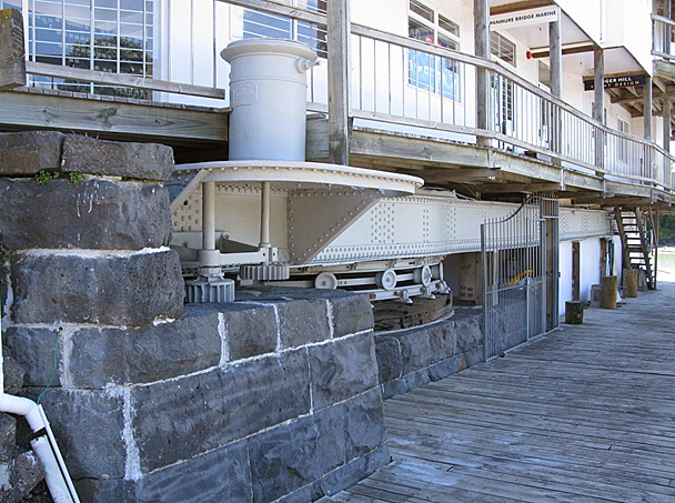
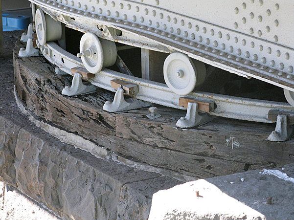
Context The Panmure Bridge Swing Span and Abutment is located in the Auckland conurbation, immediately to the southeast of Panmure town centre. Panmure is a residential and commercial suburb that was heavily redeveloped during the twentieth century. Remnants of the swing bridge are situated on the east bank of the Tamaki River, just north of the existing Pakuranga Road to Lagoon Drive bridge. Lagoon Drive and Pakuranga Road collectively form a major arterial route that connects extensive suburbs on either side of the Tamaki, including the former Fencible centres at Panmure and Howick. Both banks of the Tamaki at the crossing are lined by low-density residential housing. Dwellings on the east side are separated from the river by a strip of public land, which encompasses the swing bridge site. Visible remnants of the swing bridge include a substantial bluestone abutment on the east bank and associated parts of the 1864-5 swing bridge mechanism. They adjoin a more recent timber jetty on the north side of the bridge abutment. A large commercial building has been erected over the top of the remnants, and is supported on timber piles. Adjacent to the site is a haul-out area for keel yachts and pleasure craft. It is currently unclear if significant other bridge remnants survive on the west bank of the Tamaki or in the intervening river bed. Visible stone revetments on the west side appear to be of different construction, and are probably more recent in date. A deep road cutting associated with the bridge approaches on the west side does, however, clearly survive. Parts of Mokoia pa may also remain under residential housing on the west bank of the Tamaki. Nearby remnants of other historical river crossings and associated activities survive. The site of the mid-nineteenth century ferry crossing is visible a few hundred metres to the north of the swing bridge. Between the ferry crossing site and swing bridge remnants, the ferro-concrete approaches to the 1916 bridge have been preserved. A public walkway between these sites also connects with the Pakuranga Landing, a concrete jetty erected by American military forces in the Second World War. The site The site occupies a broadly rectangular area on the east bank of the river and extending a short distance into the bed of the Tamaki. It provides relatively picturesque views of the Tamaki and the entrance to the Panmure Basin on the opposite side of the river. The site extent encompasses the swing bridge remnants, but excludes the overlying building of late-twentieth century date. Some piles supporting the latter building rest on top of the bridge remnants. Swing bridge remnants within the site comprise i) a large stone abutment, ii) an iron turntable, including rails, wheel pivots and timber ring plate; iii) parts of a swing section superstructure, including iron I-beams, edge-beams and joists; and iv) a turning mechanism and platform. Stone abutment The stone abutment is well-preserved, and approximately rectangular in plan. It survives to its full original height in most places, stepping down successively from east to west in two stages. These stages respectively accommodate the swing bridge superstructure and an underlying turntable. Upper stone courses at the easternmost end of the abutment have been slightly reduced in height to accommodate a more recent, overlying building. The abutment is constructed of large, ashlar blocks of Melbourne basalt or bluestone, laid to regular courses. Most blocks appear to be rectangular, and are closely fitted. Their external finish is rusticated, providing the abutment with a solid and rugged appearance. The stones are bonded with a lime or early cement mortar. The stones retain evidence of construction or quarrying methods. Some incorporate iron clamps, which helped to secure the stonework. Others have narrow slots in the centre of their uppermost face. Tool marks are visible in some instances. Carved initials of a worn nature can be seen on the upper face of some stonework, possibly either indicating historical graffiti or stonemasons’ marks. These include what appears to be ‘D B’ on the top of one of the stones near the southeast corner of the abutment. A large, semi-circular recess formed by rebated stonework is located in the top of the abutment, towards the west end of the central stage. This once accommodated a cogged or toothed plate, which connected a manually-operated winding mechanism on top of the bridge with the moveable superstructure that could be swung horizontally from an open to closed position, and vice versa. Vertical iron bolts for securing the plate remain. Turntable Attached directly to the top of the lower stage of the abutment is a turntable. The turntable enabled the moveable superstructure to pivot. From bottom to top, it includes a timber ring base-plate or sleeper; a fixed bottom rail of iron; iron wheels; and a moving top rail or track that is fixed to the swing bridge superstructure. The timber ring plate or sleeper is circular in plan. It is of double-thickness design and may be of Australian hardwood. The sleeper is set in a mortar bed and otherwise held to the basalt abutment through the use of threaded rods secured by square nuts. Joints connecting separate sections of timber sleeper show signs of having been filled with lead. The iron bottom rail sits on top of the timber sleeper. It is similarly circular in plan. It is made up of lengths of iron rail, which are joined together using bolted iron plate. The rail is secured to the timber sleeper by cast iron clamps. Wheels running on top of the rail are also of cast iron design. Wooden facsimiles were placed in the position of missing wheels during conservation work in 2013. Iron superstructure The iron superstructure represents the surviving swing span, which once rotated 90 degrees to allow boats to pass through the shipping channel. The remaining superstructure comprises a central pivot; a series of I-beams that radiate from the pivot; a circular boxed beam that connects the radial beams; edge beams to the bridge, which extend along the surviving length of the swing span; base plates on top of the edge beams for two (removed) lattice iron pillars; and T-section joists, extending across the full width of the bridge. The central pivot or axel is of cast iron and fixed to the basalt abutment with hold down bolts. Six tapering I-beams radiate from the top of the pivot, and end in a circular boxed beam which sits on the top rail of the turntable. The latter two elements are held together by cast iron clamps. Large edge beams extend along each side of the superstructure. These include the original external faces of the swing span, and are riveted. Cast iron base plates on top of the edge beams indicate the position of original lattice iron pillars that held the stays for the bridge. T-section joists of riveted iron plate design sit over the circular ring beam, the edge beams and secondary beams. These originally supported kauri timber decking for the swing span, which has been removed. Platform and turning mechanism A platform and turning mechanism are located at the eastern end of the superstructure, on its north side. The platform would have allowed a bridge keeper or caretaker to stand clear of the main carriageway while manually winching the swing span into the required position. The small, cast iron platform is riveted to the north side of the north edge beam. It supports a circular drum that encloses the winching mechanism. The drum incorporates embossed lettering on two sides that states ‘P.N. RUSSELL & Co.. – No.. – ENGINEERS – 3 – SYDNEY, 1864’. The setting for a handle survives, and would have turned a spindle inside the drum. The spindle operated a surviving toothed cog beneath the platform that would have connected with the (removed) circular toothed plate described as part of the abutment, above, to move the swing bridge sideways. A second cog, attached to the underside of the platform, assisted with this process. Comparisons Swing span bridges form part of a larger group of movable bridges that were built in New Zealand in the nineteenth and early twentieth centuries. Other types of movable bridges erected during this period included lift span, drawbridge and bascule bridges. The advantage of such structures was that they allowed water navigation and road (or rail) travel to be simultaneously accommodated. They can be seen to reflect New Zealand’s reliance on waterborne transport to serve its coastline and river network prior to the domination of road and rail. A number of swing span bridges were erected in New Zealand prior to 1939. As early as 1853, swing bridges were suggested for a proposed railway in Nelson. In 1862, the Canterbury Provincial Government approved construction of two large swing span bridges, at Kaiapoi and Heathcote. Completed in 1863, the Kaiapoi Swing Bridge incorporated an iron swing mechanism that was made at Anderson’s Iron Works in Cashel Street, Christchurch. The swing span was modified in 1869 and the structure converted to a lift span bridge in 1885. The Heathcote Swing Bridge opened in April 1864, using an iron mechanism manufactured by Robert Stephenson and Company of Newcastle-upon-Tyne, England. After the bridge was decommissioned in 1907, its swing span was relocated to Swanns Road, then moved to Bowenvale in 1955, when it was shortened to 35 feet. It survives as a fixed, single-span bridge, although the pivot no longer exists. The Panmure bridge (1864-5) appears to have been the first major swing span structure erected in the North Island. Like the Kaiapoi and Heathcote structures, it combined an iron swing span with a bridge that was otherwise predominantly constructed of timber. Unlike these previous examples, however, the span pivoted from an abutment on one of the river banks rather than from a central pier in the middle of the bridge. This configuration is likely to have contributed to its ‘in situ’ survival. The Panmure bridge remnants form the earliest ‘in situ’ swing span structure in New Zealand; and incorporate the earliest surviving swing span mechanism in the country. The mechanism is also the earliest in this country to have been manufactured in Australia. Later swing bridges include the Wanganui Bridge, which was constructed by the Wellington Provincial Government in 1869-1871, and subsequently demolished. Its contractor was Henry O’Neill, who had previously erected the Panmure bridge. A swing span bridge over the Heathcote River at Radley (1881) was reported to have been the first bridge of its type in Canterbury that did not require imported components. An additional swing span bridge was erected over the Heathcote at Woolston in c.1880, which has also since been removed. Other swing span bridges include the Waihou River Rail Bridge at Te Aroha (1885), the movable component of which was relocated nearly 30 years later for use as a functioning swing span on the Netherton, or Waihou River Bridge at Puke near Paeroa (completed 1915). The Netherton swing span has since been fixed in the closed position. The Kopu Bridge, also traversing the Waihou (1926-8; NZHPT Register No. 4681, Category 1 historic place), is considered to be the only intact bridge of swing span type in the country. Other surviving types of movable bridges are also comparatively rare. Lift bridges over the Heathcote (1907) and at Mokau (1928) have both been demolished. Of the few bascule bridges erected, the Roebuck Road Bridge over the Taraheru River in Gisborne was completed in 1908 and demolished in 1958. A bridge over the Wairoa at Dargaville (completed in 1925) has also since been removed. The Western Viaduct Bridge in Auckland (part of NZHPT Register No. 7158, Harbour Historic Area) was completed in 1932 and still survives in working condition. Like the Panmure bridge mechanism, it is manually operated.
Context The Panmure Bridge Swing Span and Abutment is located in the Auckland conurbation, immediately to the southeast of Panmure town centre. Panmure is a residential and commercial suburb that was heavily redeveloped during the twentieth century. Remnants of the swing bridge are situated on the east bank of the Tamaki River, just north of the existing Pakuranga Road to Lagoon Drive bridge. Lagoon Drive and Pakuranga Road collectively form a major arterial route that connects extensive suburbs on either side of the Tamaki, including the former Fencible centres at Panmure and Howick. Both banks of the Tamaki at the crossing are lined by low-density residential housing. Dwellings on the east side are separated from the river by a strip of public land, which encompasses the swing bridge site. Visible remnants of the swing bridge include a substantial bluestone abutment on the east bank and associated parts of the 1864-5 swing bridge mechanism. They adjoin a more recent timber jetty on the north side of the bridge abutment. A large commercial building has been erected over the top of the remnants, and is supported on timber piles. Adjacent to the site is a haul-out area for keel yachts and pleasure craft. It is currently unclear if significant other bridge remnants survive on the west bank of the Tamaki or in the intervening river bed. Visible stone revetments on the west side appear to be of different construction, and are probably more recent in date. A deep road cutting associated with the bridge approaches on the west side does, however, clearly survive. Parts of Mokoia pa may also remain under residential housing on the west bank of the Tamaki. Nearby remnants of other historical river crossings and associated activities survive. The site of the mid-nineteenth century ferry crossing is visible a few hundred metres to the north of the swing bridge. Between the ferry crossing site and swing bridge remnants, the ferro-concrete approaches to the 1916 bridge have been preserved. A public walkway between these sites also connects with the Pakuranga Landing, a concrete jetty erected by American military forces in the Second World War. The site The site occupies a broadly rectangular area on the east bank of the river and extending a short distance into the bed of the Tamaki. It provides relatively picturesque views of the Tamaki and the entrance to the Panmure Basin on the opposite side of the river. The site extent encompasses the swing bridge remnants, but excludes the overlying building of late-twentieth century date. Some piles supporting the latter building rest on top of the bridge remnants. Swing bridge remnants within the site comprise i) a large stone abutment, ii) an iron turntable, including rails, wheel pivots and timber ring plate; iii) parts of a swing section superstructure, including iron I-beams, edge-beams and joists; and iv) a turning mechanism and platform. Stone abutment The stone abutment is well-preserved, and approximately rectangular in plan. It survives to its full original height in most places, stepping down successively from east to west in two stages. These stages respectively accommodate the swing bridge superstructure and an underlying turntable. Upper stone courses at the easternmost end of the abutment have been slightly reduced in height to accommodate a more recent, overlying building. The abutment is constructed of large, ashlar blocks of Melbourne basalt or bluestone, laid to regular courses. Most blocks appear to be rectangular, and are closely fitted. Their external finish is rusticated, providing the abutment with a solid and rugged appearance. The stones are bonded with a lime or early cement mortar. The stones retain evidence of construction or quarrying methods. Some incorporate iron clamps, which helped to secure the stonework. Others have narrow slots in the centre of their uppermost face. Tool marks are visible in some instances. Carved initials of a worn nature can be seen on the upper face of some stonework, possibly either indicating historical graffiti or stonemasons’ marks. These include what appears to be ‘D B’ on the top of one of the stones near the southeast corner of the abutment. A large, semi-circular recess formed by rebated stonework is located in the top of the abutment, towards the west end of the central stage. This once accommodated a cogged or toothed plate, which connected a manually-operated winding mechanism on top of the bridge with the moveable superstructure that could be swung horizontally from an open to closed position, and vice versa. Vertical iron bolts for securing the plate remain. Turntable Attached directly to the top of the lower stage of the abutment is a turntable. The turntable enabled the moveable superstructure to pivot. From bottom to top, it includes a timber ring base-plate or sleeper; a fixed bottom rail of iron; iron wheels; and a moving top rail or track that is fixed to the swing bridge superstructure. The timber ring plate or sleeper is circular in plan. It is of double-thickness design and may be of Australian hardwood. The sleeper is set in a mortar bed and otherwise held to the basalt abutment through the use of threaded rods secured by square nuts. Joints connecting separate sections of timber sleeper show signs of having been filled with lead. The iron bottom rail sits on top of the timber sleeper. It is similarly circular in plan. It is made up of lengths of iron rail, which are joined together using bolted iron plate. The rail is secured to the timber sleeper by cast iron clamps. Wheels running on top of the rail are also of cast iron design. Wooden facsimiles were placed in the position of missing wheels during conservation work in 2013. Iron superstructure The iron superstructure represents the surviving swing span, which once rotated 90 degrees to allow boats to pass through the shipping channel. The remaining superstructure comprises a central pivot; a series of I-beams that radiate from the pivot; a circular boxed beam that connects the radial beams; edge beams to the bridge, which extend along the surviving length of the swing span; base plates on top of the edge beams for two (removed) lattice iron pillars; and T-section joists, extending across the full width of the bridge. The central pivot or axel is of cast iron and fixed to the basalt abutment with hold down bolts. Six tapering I-beams radiate from the top of the pivot, and end in a circular boxed beam which sits on the top rail of the turntable. The latter two elements are held together by cast iron clamps. Large edge beams extend along each side of the superstructure. These include the original external faces of the swing span, and are riveted. Cast iron base plates on top of the edge beams indicate the position of original lattice iron pillars that held the stays for the bridge. T-section joists of riveted iron plate design sit over the circular ring beam, the edge beams and secondary beams. These originally supported kauri timber decking for the swing span, which has been removed. Platform and turning mechanism A platform and turning mechanism are located at the eastern end of the superstructure, on its north side. The platform would have allowed a bridge keeper or caretaker to stand clear of the main carriageway while manually winching the swing span into the required position. The small, cast iron platform is riveted to the north side of the north edge beam. It supports a circular drum that encloses the winching mechanism. The drum incorporates embossed lettering on two sides that states ‘P.N. RUSSELL & Co.. – No.. – ENGINEERS – 3 – SYDNEY, 1864’. The setting for a handle survives, and would have turned a spindle inside the drum. The spindle operated a surviving toothed cog beneath the platform that would have connected with the (removed) circular toothed plate described as part of the abutment, above, to move the swing bridge sideways. A second cog, attached to the underside of the platform, assisted with this process. Comparisons Swing span bridges form part of a larger group of movable bridges that were built in New Zealand in the nineteenth and early twentieth centuries. Other types of movable bridges erected during this period included lift span, drawbridge and bascule bridges. The advantage of such structures was that they allowed water navigation and road (or rail) travel to be simultaneously accommodated. They can be seen to reflect New Zealand’s reliance on waterborne transport to serve its coastline and river network prior to the domination of road and rail. A number of swing span bridges were erected in New Zealand prior to 1939. As early as 1853, swing bridges were suggested for a proposed railway in Nelson. In 1862, the Canterbury Provincial Government approved construction of two large swing span bridges, at Kaiapoi and Heathcote. Completed in 1863, the Kaiapoi Swing Bridge incorporated an iron swing mechanism that was made at Anderson’s Iron Works in Cashel Street, Christchurch. The swing span was modified in 1869 and the structure converted to a lift span bridge in 1885. The Heathcote Swing Bridge opened in April 1864, using an iron mechanism manufactured by Robert Stephenson and Company of Newcastle-upon-Tyne, England. After the bridge was decommissioned in 1907, its swing span was relocated to Swanns Road, then moved to Bowenvale in 1955, when it was shortened to 35 feet. It survives as a fixed, single-span bridge, although the pivot no longer exists. The Panmure bridge (1864-5) appears to have been the first major swing span structure erected in the North Island. Like the Kaiapoi and Heathcote structures, it combined an iron swing span with a bridge that was otherwise predominantly constructed of timber. Unlike these previous examples, however, the span pivoted from an abutment on one of the river banks rather than from a central pier in the middle of the bridge. This configuration is likely to have contributed to its ‘in situ’ survival. The Panmure bridge remnants form the earliest ‘in situ’ swing span structure in New Zealand; and incorporate the earliest surviving swing span mechanism in the country. The mechanism is also the earliest in this country to have been manufactured in Australia. Later swing bridges include the Wanganui Bridge, which was constructed by the Wellington Provincial Government in 1869-1871, and subsequently demolished. Its contractor was Henry O’Neill, who had previously erected the Panmure bridge. A swing span bridge over the Heathcote River at Radley (1881) was reported to have been the first bridge of its type in Canterbury that did not require imported components. An additional swing span bridge was erected over the Heathcote at Woolston in c.1880, which has also since been removed. Other swing span bridges include the Waihou River Rail Bridge at Te Aroha (1885), the movable component of which was relocated nearly 30 years later for use as a functioning swing span on the Netherton, or Waihou River Bridge at Puke near Paeroa (completed 1915). The Netherton swing span has since been fixed in the closed position. The Kopu Bridge, also traversing the Waihou (1926-8; NZHPT Register No. 4681, Category 1 historic place), is considered to be the only intact bridge of swing span type in the country. Other surviving types of movable bridges are also comparatively rare. Lift bridges over the Heathcote (1907) and at Mokau (1928) have both been demolished. Of the few bascule bridges erected, the Roebuck Road Bridge over the Taraheru River in Gisborne was completed in 1908 and demolished in 1958. A bridge over the Wairoa at Dargaville (completed in 1925) has also since been removed. The Western Viaduct Bridge in Auckland (part of NZHPT Register No. 7158, Harbour Historic Area) was completed in 1932 and still survives in working condition. Like the Panmure bridge mechanism, it is manually operated.
Historical and Associated Iwi / Hapū / Whānau
Public NZAA Number
R11/1708
Completion Date
4th June 2014
Report Written By
Martin Jones
Information Sources
Thornton, 2001
Geoffrey Thornton, Bridging the Gap, Early Bridges in New Zealand 1830-1939, Auckland, 2001
Matthews and Matthews Architects Ltd, 2009 (2)
Matthews and Matthews Architects Ltd., ‘Panmure Swing Bridge: Condition Report on Remnant 1866 Swing Structure’, Auckland, 31 March 2009
Holloway, 1962
Holloway, K.M., Maungarei: An Outline history of the Mt Wellington, Panmure and Tamaki Districts, Auckland, 1962
Other Information
A fully referenced report is available from the Mid-Northern Office of Heritage New Zealand Pouhere Taonga. This place has been identified in other heritage listings. The reference is Auckland Council Cultural Heritage Inventory Computer Number 118, “Panmure Bridge Abutments and Swivel Section”. Please note that entry on the New Zealand Heritage List/Rarangi Korero identifies only the heritage values of the property concerned, and should not be construed as advice on the state of the property, or as a comment of its soundness or safety, including in regard to earthquake risk, safety in the event of fire, or insanitary conditions.
Current Usages
Uses: Transport
Specific Usage: Wharf/Dock/ Pier/ Jetty
Former Usages
General Usage: Transport
Specific Usage: Bridge/ Viaduct
Web Links
description: Engineering NZ Heritage
url: https://www.engineeringnz.org/our-work/heritage/heritage-records/tamaki-river-bridge/
Current Usages
Uses: Transport
Specific Usage: Wharf/Dock/ Pier/ Jetty
Former Usages
General Usage: Transport
Specific Usage: Bridge/ Viaduct
Web Links
description: Engineering NZ Heritage
url: https://www.engineeringnz.org/our-work/heritage/heritage-records/tamaki-river-bridge/
Location
Sign up to hear more
Get the latest heritage news, features and events delivered
straight to your inbox.
