Māori knew Quail Island as Te Kawakawa and also Ōtamahua, the place to gather seabird eggs. Aua / King Billy Island was an important area for Māori as a source of sandstone prized for grinding pounamu and other stone implements. In 1842 Captain William Mein Smith, purportedly the first European to visit the main island, named it Quail Island after koreke, the native quail that he found there.
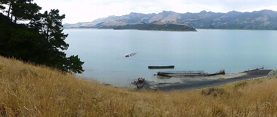
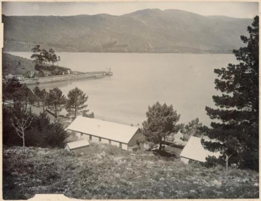
The 80 hectare Ōtamahua / Quail Island and the much smaller 0.36 hectare islet to its south known as Aua / King Billy Island lie near the head of Lyttelton Harbour / Whakaraupō off Moepuku Point. At low tide an exposed mudflat stretches from this point, around Aua / King Billy Island, to the southern side of Ōtamahua / Quail Island. Aua / King Billy Island is composed of the sedimentary rock Charteris Bay Sandstone, and contains vegetation and archaeological evidence of quarries, landing sites and midden. Ōtamahua / Quail Island is composed of two types of volcanic rock - rhyolite in the southern part and basalt in the north - and includes a large number of physical items and landscape modifications which represent the area’s varied past. Archaeological sites such as midden and umu are found around the coast. At the north of the Ōtamahua / Quail Island is the archaeological site where the Ward brothers, the first European inhabitants of the island, established their cottage and garden in 1851. Stone quarrying areas are found in a number of places, especially in the north-west and south. At the east side of the island are buildings relating to animal quarantine. By the southern bays are remnants of the human quarantine station, including leper colony. Just off the west coast is the ships’ graveyard and Walker’s Beach at the south was the site of shell grit harvesting. Evidence of water management includes at least eight concrete reservoirs around the island and a dam for livestock at the north of the island. Many of the historic features are actively managed and maintained. Visitors to the island mostly arrive by ferry to the wharf at the east of Ōtamahua / Quail Island, constructed in the early 1980s, and take the walking track around the island which incorporates old dray tracks, steps, drains and stone walls.
Colonial settlers farmed the island from 1851 but its importance increased after 1874 when the Canterbury Provincial Government agreed to use it as a human quarantine station. Utilitarian barracks buildings were constructed in 1874. In February 1875 the Rakaia, full of ill passengers, became the first ship to use the newly built Ōtamahua / Quail Island quarantine facilities. The need for isolating immigrants with infectious diseases declined from the 1880s but human quarantining continued as needs arose, such as through the establishment of a small leper colony between 1906 and 1925 and during the Spanish influenza epidemic in 1918 and 1919.
Livestock were also quarantined on Ōtamahua / Quail Island from 1881. The most famous related to the use of the island for quarantining and training dogs and ponies (and later mules) for four separate Antarctic expeditions between 1901 and 1929. After the animal quarantine station closed in 1931, Quail Island was leased to farmers, who allowed limited public access. Then, after many years of being set apart, in the late 1970s and early 1980s Ōtamahua / Quail Island refocused to become a recreation destination. The Ōtamahua / Quail Island Restoration Trust has been carrying out a restoration programme since 1998. While geographically and historically linked, Aua / King Billy Island, a Scenic Reserve, is not actively promoted for visitation.


List Entry Information
Status
Listed
List Entry Status
Historic Area
Access
Able to Visit
List Number
9552
Date Entered
17th May 2018
Date of Effect
7th June 2018
City/District Council
Christchurch City
Region
Canterbury Region
Extent of List Entry
This historic area consists of an area of land that contains a group of inter-related historic places. The identified historic places that contribute to the values in this historic area are: Human Quarantine Station archaeological site including Quarantine Barracks; Relocated Akaroa Head Lighthouse Keeper’s Cottage; Animal Quarantine Caretaker’s Cottage (Former); Remains of Nurse’s Quarters; Quarantine Stables, Yards and Machinery; Reservoirs; Earthworks, Tracks, Road and Drains; Stone Walls; Quarries; Stock Wharf Remains; Dog Kennel Site and Replica Kennel; Remains of Leper Colony; Leprosy Colony Burial Ground; Ward Brothers Cottage Site; Stock Water Dam; Ships’ Graveyard and the recorded archaeological sites on Aua / King Billy Island. The area of land that encompasses these historic places includes the land described as RS 40620 (NZ Gazette 1982, p. 2434) and RS 1566 (RT CB15A/972, NZ Gazette, 1980, p. 1808) and part of the land described as Seabed and the Ships’ Graveyard thereon, as shown on Lyttelton Harbour Chart NZ 3261, Canterbury Land District. Within the boundary of the historic area there are places that do not contribute to the values of the historic area and are therefore excluded from the group of inter-related historic places that form part of this historic area. These include interpretation signs, the 1980s ferry wharf and associated shelter, implement shed adjacent to the remains of the nurse’s quarters, tank farm, toilet block at Skiers (Lepers) Beach, and the large shed east of the Quarantine Barracks at Whakamaru Beach. (Refer to map in Appendix 1 of the List entry report for further information).
Legal description
RS 40620 (NZ Gazette 1982, p. 2434), RS 1566 (RT CB15A/972, NZ Gazette, 1980, p. 1808) and Seabed, Canterbury Land District.
Status
Listed
List Entry Status
Historic Area
Access
Able to Visit
List Number
9552
Date Entered
17th May 2018
Date of Effect
7th June 2018
City/District Council
Christchurch City
Region
Canterbury Region
Extent of List Entry
This historic area consists of an area of land that contains a group of inter-related historic places. The identified historic places that contribute to the values in this historic area are: Human Quarantine Station archaeological site including Quarantine Barracks; Relocated Akaroa Head Lighthouse Keeper’s Cottage; Animal Quarantine Caretaker’s Cottage (Former); Remains of Nurse’s Quarters; Quarantine Stables, Yards and Machinery; Reservoirs; Earthworks, Tracks, Road and Drains; Stone Walls; Quarries; Stock Wharf Remains; Dog Kennel Site and Replica Kennel; Remains of Leper Colony; Leprosy Colony Burial Ground; Ward Brothers Cottage Site; Stock Water Dam; Ships’ Graveyard and the recorded archaeological sites on Aua / King Billy Island. The area of land that encompasses these historic places includes the land described as RS 40620 (NZ Gazette 1982, p. 2434) and RS 1566 (RT CB15A/972, NZ Gazette, 1980, p. 1808) and part of the land described as Seabed and the Ships’ Graveyard thereon, as shown on Lyttelton Harbour Chart NZ 3261, Canterbury Land District. Within the boundary of the historic area there are places that do not contribute to the values of the historic area and are therefore excluded from the group of inter-related historic places that form part of this historic area. These include interpretation signs, the 1980s ferry wharf and associated shelter, implement shed adjacent to the remains of the nurse’s quarters, tank farm, toilet block at Skiers (Lepers) Beach, and the large shed east of the Quarantine Barracks at Whakamaru Beach. (Refer to map in Appendix 1 of the List entry report for further information).
Legal description
RS 40620 (NZ Gazette 1982, p. 2434), RS 1566 (RT CB15A/972, NZ Gazette, 1980, p. 1808) and Seabed, Canterbury Land District.
Why is this place significant?
Cultural Significance
Cultural Significance or Value Ōtamahua / Quail Island and Aua / King Billy Island have cultural significance to Ngāi Tahu. There is a particular connection between these places and Te Hapū o Ngāti wheke (Rāpaki), who hold mana whenua. Ōtamahua, also known as Te Kawa-Kawa, was used by local Maori in Whakaraupō for customary activities such as collecting seabird eggs and fishing. Aua is culturally significant as the source of prized sandstone which was a grinding agent for pounamu and other stone implements. Social Significance or Value Ōtamahua / Quail Island, a recreation reserve, has social significance. People from all walks of life have had an association with Ōtamahua / Quail Island through its many and varied themes, including farming, ballast trade, immigration, quarantine, health care and convalescence, prison work parties, industrial school pupils, Antarctic expeditions, sea cadets and scouts, shell grit harvesting, school class visits and camps, and general recreationalists. It remains important to numerous groups, especially those living in the Lyttelton Harbour / Whakaraupō area, where the island is a key feature. The island is a place where groups make an effort to arrive at and spend time together. Mostly this is for recreation and discovery purposes. Working alongside the Department of Conservation, and Ngāti Wheke as a trustee, the Ōtamahua / Quail Island Restoration Trust formed as a group in 1998 and volunteer members frequently gather on the island to undertake ecological restoration planting.
Historic Significance
Historical Significance or Value Ōtamahua / Quail Island in particular has historical significance, covering a number of important themes in New Zealand history. The Crown’s purchase of Ōtamahua / Quail Island and use, over time, for a diverse range of uses beyond grazing and quarrying recognises its strategic importance to the province and colony. The human quarantine station and animal quarantine station were important in the history of colonial settlement of Canterbury. The utilisation of prison labour for the construction of infrastructure relating to these stations contributes to the history of the penal system. The development of part of the island in the early twentieth century as New Zealand’s only leper colony is integral to understanding the country’s response to this disease. The theme of human quarantining continued through the first decades of the twentieth century, with Ōtamahua / Quail Island being used as a place of convalescence for patients with the world-wide pandemic Spanish influenza. Ōtamahua / Quail Island is well known nationally and internationally because of its association with the heroic age of Antarctic expeditions and the quarantining and training of expedition dogs, ponies and mules on the island.
Physical Significance
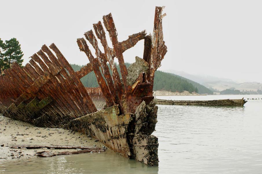
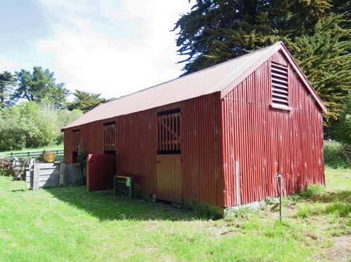
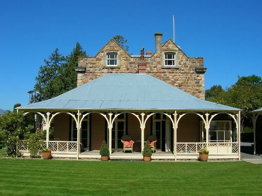
Aesthetic Significance or Value Ōtamahua / Quail Island historic area has aesthetic significance. As a group of two islands within a picturesque harbour formed from ancient volcanic activity, the historic area appeals directly to our senses. Changing with the weather, sea conditions and season, the historic area combines evocative sights, sounds, smells and feel. Ōtamahua / Quail Island particularly has visual appeal and is often photographed, especially at the site of the Ships’ Graveyard. Archaeological Significance or Value Ōtamahua / Quail Island historic area has high archaeological significance. Both Ōtamahua / Quail Island and Aua / King Billy Island have many places, covering a range of phases of occupation, that provide physical evidence of human activity that can be investigated using archaeological methods. Throughout the historic area there is potential for recovering information about activities not available through historical documents. The sites of pre-European Māori activity have value because of their age, archaeological potential and cultural values. Of the European sites, both the Ward settlement complex and human quarantine area are considered to be of exceptional archaeological value. Not only is the Ward settlement complex evidence of early colonial settlement activity but the archaeology complements extant records detailing what was there in the 1850s. Similarly, the human quarantine area, including the leper colony site, provides archaeological evidence and potential to understand more about the efforts to separate those who might have a contagious disease from those who don’t and the resulting lifestyle of the segregated. The quarries, too, have archaeological value as a visual reminder of the efforts to obtain stone ballast for sailing ships and stone for construction. Architectural Significance or Value Ōtamahua / Quail Island historic area includes some places that are of architectural value. These are the Immigration Barracks, the Quarantine caretaker’s cottage, the Quarantine Stables and the replica Leper Colony Patients’ Hut. The utilitarian Immigration Barracks, with its balloon framing, ship-lap weatherboard cladding and match-lined interior, demonstrates the functional construction required for short-term accommodation of newly arrived ships’ passengers. The Quarantine caretakers’ cottage references the Arts and Crafts style, displaying a modest degree of decoration, with moulded timber posts within the deep verandah and carved brackets supporting projecting casement windows. The Quarantine Stables have some architectural value as being representative of a typical utilitarian farm building, constructed of basic materials that suit their purpose, the interior of which retains in-built features including feed box and chaff box. Although not authentic in materials, the replica Leper Colony Patients’ Hut has some architectural value in its ability to represent the physical attributes of the original small timber huts built specifically for those patients confined at the colony.
Why is this place significant?
Cultural Significance
Cultural Significance or Value Ōtamahua / Quail Island and Aua / King Billy Island have cultural significance to Ngāi Tahu. There is a particular connection between these places and Te Hapū o Ngāti wheke (Rāpaki), who hold mana whenua. Ōtamahua, also known as Te Kawa-Kawa, was used by local Maori in Whakaraupō for customary activities such as collecting seabird eggs and fishing. Aua is culturally significant as the source of prized sandstone which was a grinding agent for pounamu and other stone implements. Social Significance or Value Ōtamahua / Quail Island, a recreation reserve, has social significance. People from all walks of life have had an association with Ōtamahua / Quail Island through its many and varied themes, including farming, ballast trade, immigration, quarantine, health care and convalescence, prison work parties, industrial school pupils, Antarctic expeditions, sea cadets and scouts, shell grit harvesting, school class visits and camps, and general recreationalists. It remains important to numerous groups, especially those living in the Lyttelton Harbour / Whakaraupō area, where the island is a key feature. The island is a place where groups make an effort to arrive at and spend time together. Mostly this is for recreation and discovery purposes. Working alongside the Department of Conservation, and Ngāti Wheke as a trustee, the Ōtamahua / Quail Island Restoration Trust formed as a group in 1998 and volunteer members frequently gather on the island to undertake ecological restoration planting.
Historic Significance
Historical Significance or Value Ōtamahua / Quail Island in particular has historical significance, covering a number of important themes in New Zealand history. The Crown’s purchase of Ōtamahua / Quail Island and use, over time, for a diverse range of uses beyond grazing and quarrying recognises its strategic importance to the province and colony. The human quarantine station and animal quarantine station were important in the history of colonial settlement of Canterbury. The utilisation of prison labour for the construction of infrastructure relating to these stations contributes to the history of the penal system. The development of part of the island in the early twentieth century as New Zealand’s only leper colony is integral to understanding the country’s response to this disease. The theme of human quarantining continued through the first decades of the twentieth century, with Ōtamahua / Quail Island being used as a place of convalescence for patients with the world-wide pandemic Spanish influenza. Ōtamahua / Quail Island is well known nationally and internationally because of its association with the heroic age of Antarctic expeditions and the quarantining and training of expedition dogs, ponies and mules on the island.
Physical Significance
Aesthetic Significance or Value Ōtamahua / Quail Island historic area has aesthetic significance. As a group of two islands within a picturesque harbour formed from ancient volcanic activity, the historic area appeals directly to our senses. Changing with the weather, sea conditions and season, the historic area combines evocative sights, sounds, smells and feel. Ōtamahua / Quail Island particularly has visual appeal and is often photographed, especially at the site of the Ships’ Graveyard. Archaeological Significance or Value Ōtamahua / Quail Island historic area has high archaeological significance. Both Ōtamahua / Quail Island and Aua / King Billy Island have many places, covering a range of phases of occupation, that provide physical evidence of human activity that can be investigated using archaeological methods. Throughout the historic area there is potential for recovering information about activities not available through historical documents. The sites of pre-European Māori activity have value because of their age, archaeological potential and cultural values. Of the European sites, both the Ward settlement complex and human quarantine area are considered to be of exceptional archaeological value. Not only is the Ward settlement complex evidence of early colonial settlement activity but the archaeology complements extant records detailing what was there in the 1850s. Similarly, the human quarantine area, including the leper colony site, provides archaeological evidence and potential to understand more about the efforts to separate those who might have a contagious disease from those who don’t and the resulting lifestyle of the segregated. The quarries, too, have archaeological value as a visual reminder of the efforts to obtain stone ballast for sailing ships and stone for construction. Architectural Significance or Value Ōtamahua / Quail Island historic area includes some places that are of architectural value. These are the Immigration Barracks, the Quarantine caretaker’s cottage, the Quarantine Stables and the replica Leper Colony Patients’ Hut. The utilitarian Immigration Barracks, with its balloon framing, ship-lap weatherboard cladding and match-lined interior, demonstrates the functional construction required for short-term accommodation of newly arrived ships’ passengers. The Quarantine caretakers’ cottage references the Arts and Crafts style, displaying a modest degree of decoration, with moulded timber posts within the deep verandah and carved brackets supporting projecting casement windows. The Quarantine Stables have some architectural value as being representative of a typical utilitarian farm building, constructed of basic materials that suit their purpose, the interior of which retains in-built features including feed box and chaff box. Although not authentic in materials, the replica Leper Colony Patients’ Hut has some architectural value in its ability to represent the physical attributes of the original small timber huts built specifically for those patients confined at the colony.
Construction Professional
Name
H A Bolstead
Type
Architect
Biography
Architect, Public Works Department - designed the sanitary block at the Quail Island Leper Colony. Source: Proposal Report for Ōtamahua / Quail Island Historic Area, LYTTELTON HARBOUR, List No. 9552, 14 May 2018, Robyn Burgess
Name
Mr Gee
Type
Builder
Biography
Builder of the Quarantine Barracks on Otamahua / Quail Island. c. 1874 Source: Proposal Report for Ōtamahua / Quail Island Historic Area, LYTTELTON HARBOUR, List No. 9552, 14 May 2018, Robyn Burgess
Name
Andrew Farquharson Laurenson
Type
Builder
Biography
Carpenter, resided Ōtamahua / Quail Island 1896-1901. Source: Proposal Report for Ōtamahua / Quail Island Historic Area, LYTTELTON HARBOUR, List No. 9552, 14 May 2018, Robyn Burgess
Name
Public Works Department
Type
Architect
Biography
No biography is currently available for this construction professional
Construction Details
Type
Other
Description
Māori use of Ōtamahua / Quail Island and Aua / King Billy Island
Period
Prior to 1850
Start Year
1851
Type
Original Construction
Description
Construction of house by Ward Brothers
Type
Other
Description
Columnar basalt rock from two areas on Ōtamahua / Quail Island quarried for use as ballast
Period
1850s-1874
Start Year
1874
Type
Original Construction
Description
Quarantine quarters constructed. Stone walls began to be constructed (hard labour)
Type
Original Construction
Description
Stock dam constructed
Period
1860s, 1880s
Type
Original Construction
Description
Dog kennels constructed
Period
1890s?
Type
Other
Description
Twelve ships dumped in the Ships’ Graveyard
Period
1902-1953
Type
Original Construction
Description
Leper colony buildings constructed
Period
1907-1920s
Start Year
1979
Type
Additional building added to site
Description
Akaroa Head Lighthouse Relief Keepers Cottage relocated to Ōtamahua / Quail Island
Start Year
1985
Type
Modification
Description
Quarantine Barracks old extension removed from east end and new toilet block built in its place
Start Year
1995
Type
Structural upgrade
Description
Quarantine Barracks repiled
Start Year
1998
Type
Additional building added to site
Description
Replica Dog Kennel constructed
Start Year
2002
Type
Additional building added to site
Description
Replica Leper Hut constructed
Construction Materials
Timber, clay, brick, stone, glass, iron, steel.
Construction Professional
Name
H A Bolstead
Type
Architect
Biography
Architect, Public Works Department - designed the sanitary block at the Quail Island Leper Colony. Source: Proposal Report for Ōtamahua / Quail Island Historic Area, LYTTELTON HARBOUR, List No. 9552, 14 May 2018, Robyn Burgess
Name
Mr Gee
Type
Builder
Biography
Builder of the Quarantine Barracks on Otamahua / Quail Island. c. 1874 Source: Proposal Report for Ōtamahua / Quail Island Historic Area, LYTTELTON HARBOUR, List No. 9552, 14 May 2018, Robyn Burgess
Name
Andrew Farquharson Laurenson
Type
Builder
Biography
Carpenter, resided Ōtamahua / Quail Island 1896-1901. Source: Proposal Report for Ōtamahua / Quail Island Historic Area, LYTTELTON HARBOUR, List No. 9552, 14 May 2018, Robyn Burgess
Name
Public Works Department
Type
Architect
Biography
No biography is currently available for this construction professional
Construction Details
Type
Other
Description
Māori use of Ōtamahua / Quail Island and Aua / King Billy Island
Period
Prior to 1850
Start Year
1851
Type
Original Construction
Description
Construction of house by Ward Brothers
Type
Other
Description
Columnar basalt rock from two areas on Ōtamahua / Quail Island quarried for use as ballast
Period
1850s-1874
Start Year
1874
Type
Original Construction
Description
Quarantine quarters constructed. Stone walls began to be constructed (hard labour)
Type
Original Construction
Description
Stock dam constructed
Period
1860s, 1880s
Type
Original Construction
Description
Dog kennels constructed
Period
1890s?
Type
Other
Description
Twelve ships dumped in the Ships’ Graveyard
Period
1902-1953
Type
Original Construction
Description
Leper colony buildings constructed
Period
1907-1920s
Start Year
1979
Type
Additional building added to site
Description
Akaroa Head Lighthouse Relief Keepers Cottage relocated to Ōtamahua / Quail Island
Start Year
1985
Type
Modification
Description
Quarantine Barracks old extension removed from east end and new toilet block built in its place
Start Year
1995
Type
Structural upgrade
Description
Quarantine Barracks repiled
Start Year
1998
Type
Additional building added to site
Description
Replica Dog Kennel constructed
Start Year
2002
Type
Additional building added to site
Description
Replica Leper Hut constructed
Construction Materials
Timber, clay, brick, stone, glass, iron, steel.
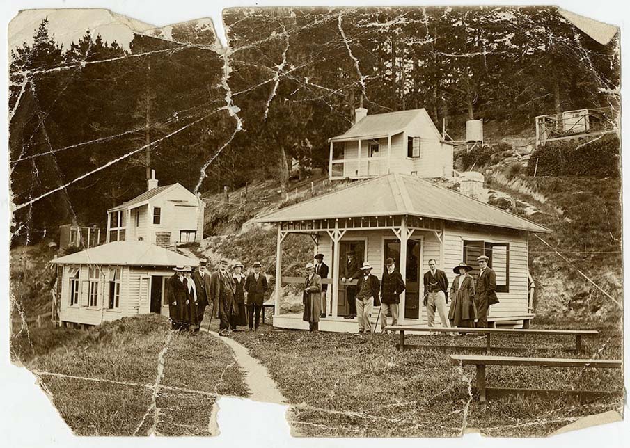
Ōtamahua / Quail Island Māori History The following text in single quotation marks is from the 2nd edition (revised) publication by Peter Jackson, Ōtamahua Quail Island – a link with the past, 2006, pp. 12-14: ‘Quail Island is called Ōtamahua, which means ‘the place where children (tamariki) collected seabirds’ eggs’ (hua). The eggs were considered a great delicacy, especially among the children who were said to have been fond of roasting them on their island expeditions. Several earth oven (umu) sites have been discovered on the island. Visits to Ōtamahua were made in canoes (waka) from Rāpaki and Kaitangata. Māori of the area would have walked across the mudflats from Moepuku to Ōtamahua during low tide. Because of the shortage of freshwater and firewood, Ōtamahua was never permanently settled by Māori. A whare (house) for shelter existed on the island at the time of the first European settlers. The shores of Ōtamahua were popular for fishing and collection of shellfish (kaimoana). Huge flax fishing nets (kupenga), up to 400 metres long, were used for catching sharks. Kupenga from two to three metres deep were worked by canoes which would take one end into the middle of the harbour while the other end was secured to a convenient point. The kupenga would be swept around the shoals of fish making their way up the harbour on the incoming tide. Huge quantities of shark and other fish were caught in this manner which was only possible when the whole strength of the hapū (sub-tribe) was available to assist. Fish were also caught in rock fish traps built around the island’s shore. They swam into the trap and were left by the receding tide. Quail Island was also known by the name of Te Kawa-kawa. This name is thought to refer to the pepper tree (macropiper excelsum) which had several important medicinal uses for Māori. Kawakawa, which reaches its southern distribution limit on Banks Peninsula has been replanted on the island. Ōtamahua is of great cultural and spiritual importance to Ngāi Tahu. Te Hapū o Ngāti Wheke (Rāpaki) hold mana whenua (customary rights) over the island. … By the time of European settlement the Ngāi Tahu population of Whakaraupō and Banks Peninsula had been greatly reduced, initially by the intertribal kai huanga feud and later by the invading forces of Te Rauparaha.’ Archaeological records identify features from Māori sites such as midden, find spots for adzes, fish traps and umu. Land Sale and Colonial settlement The harbour area of Whakaraupō caught the attention of early European colonists. Captain William Mein Smith, Surveyor General to the New Zealand Company visited the main island in 1842, evidently the first European to do so. There he ‘flushed’ several koreke (the now extinct New Zealand quail) and named the place Quail Island. In 1849 Walter Mantell, agent and surveyor for the Canterbury Association, made an agreement with Ngāi Tahu to purchase land in the Port Cooper (Lyttelton) district. Ōtamahua / Quail Island’s inclusion in the sale was controversial and disputed. Farming Early Canterbury Association settlers, the Irish brothers Edward, Henry and Hamilton Ward, won the land ballot for Quail Island in February 1851. A yawl was built immediately and building materials were taken to the island to construct a weatherboard house. This was completed in May 1851. Farming had already commenced by this time, to supply produce just across the water at the new settlement of Lyttelton. A cow, heifer and pigs were driven across the mudflats near the head of the harbour, and six goats were brought over by boat. Despite being an island, there were issues with animals escaping across the mudflats past Aua / King Billy Island and onto the mainland. In June 1851 Edward and Henry set out in the yawl to fetch firewood from the mainland, as there was little on the island, but they struck rough weather and were accidentally drowned. The younger brother, Hamilton, returned to live in Lyttelton until the arrival of another elder brother, Crosbie, from Northern Ireland. Crosbie Ward arrived in May 1852 and he and Hamilton are believed to have farmed on Quail Island for another three years before vacating the island. In April 1858 Mark Stoddart of Diamond Harbour received a Crown grant for the purchase of 100 acres of Quail Island, King Billy Island and the adjacent peninsula. Stoddart never resided on the island but rather employed a man to look after the place. When Stoddart’s land was put up for sale on 2 December 1862, improvements consisted of a five-roomed house and from 24 to 500 sheep and lambs. In 1863 the 100 acres was sold to early New Zealand naturalist, Thomas Potts. Potts acquired a further 85 acres from the Canterbury Waste Lands Board in September 1874 and 8 days later sold 100 acres to William Rolleston, Superintendent of Canterbury. Rolleston had the remaining 85 acres on Quail Island transferred to him on 13 April 1876, the land to be used for public purposes. By this time Ōtamahua / Quail Island was being used as a human quarantine station but small scale farming continued. In 1887 Quail Island was leased by the Department of Health to A A Smith. In October 1888 Smith’s lease was taken over by Christopher Brown, who constructed a stock water dam using puddle-clay backed with stones. Brown’s lease was terminated in 1892, when the whole island became an animal quarantine station. Farming had a low profile until December 1931 when the animal quarantine station closed and the island was taken over by the Department of Lands and Survey who leased it for farming until 1950. In the 1940s the Navy League Sea Cadets leased a small portion of Quail Island for training and between 1949 and 1951 leased the whole of the island. Ex-Navy League caretaker, Thomas Russell, took over the lease and, raising his family on the island, he continued farming until 1958. The final lessee was David Halliwell, who resided on the island in the former animal quarantine caretaker’s cottage between 1958 and 1975, and grew potatoes and grazed sheep. He arranged for the installation of a telephone, which was important for arranging pick-up times for his potato crops and considered essential for his safety as he was mostly living and working on his own at Quail Island. Halliwell’s lease was surrendered in the mid 1970s and the Minister of Lands set apart the Crown Land as a reserve for recreation purposes in June 1976. Ballast Quarrying The early sailing ships arriving in Lyttelton often made their return voyage without cargo but to avoid dangerous instability, columnar basalt rock could be purchased for ballast. Two ballast quarries were established on the north-west side of Ōtamahua / Quail Island, providing ballast from the early 1850s until the mid-1870s. Men quarried the rock, loaded it into a lighter and took it to Lyttelton where it was sold. As well as the actual quarries, basalt was collected from the natural beach deposits for ballast or other purposes. By the 1860s more produce and goods were grown and manufactured in Canterbury for export and more ships were then able to carry cargo in their return journeys away from the port of Lyttelton, but the ballast quarrying at Quail Island continued until the mid-1870s. In the 1980s the northern-most ballast quarry was re-opened, and a cableway constructed, to extract rock to rebuild the sea walls at the current ferry wharf and repairs around Whakamaru Beach. Human Quarantine Station and Leper Colony During the last quarter of the nineteenth century and the first three decades of the twentieth century much of Ōtamahua / Quail Island was used as a human quarantine station. From 1851, ships arriving in Lyttelton with passengers with infectious or contagious diseases were placed in quarantine and were required to fly a yellow flag during the day and show a lantern at night. After three months in cramped conditions at sea, the quarantining of a vessel was common. In 1863 a quarantine station was established at Camp Bay (on the south side of Lyttelton Harbour / Whakaraupō) and in 1873 a new one was erected on Ripapa Island in the harbour. Thoughts of running Ōtamahua / Quail Island as a quarantine station appear to have surfaced in early 1868 and in March 1874 Thomas Potts invited the Canterbury Provincial Government to establish a quarantine station at the southern part the island. The offer was accepted and work commenced on buildings before the island was actually purchased from Potts by the Provincial Government. A contemporary account in October 1874 described the new quarantine station as comprising two timber buildings capable of accommodating twelve families and two galvanised iron buildings for a large kitchen and day room. The first use of Ōtamahua / Quail Island’s quarantine station facilities appears to have been in February 1875 when the Rakaia arrived after an 81 day journey from Plymouth, England, the ship full of illness. Eleven people had died on board, there were 100 cases of mumps, 55 cases of measles and eight cases of scarlet fever. The 66 single men were taken to the island for a ten day stay, while the remaining 159 adults and 60 single girls went to the Ripapa Island quarantine facilities. Other quarantine station buildings, including a hospital, were also built. From the late 1870s the station tended to be used more for the isolation and convalescence of people with infectious diseases who were already in New Zealand, as opposed to those arriving. In 1879 it was used as a convalescent sanatorium for children from the Lyttelton Orphanage with diphtheria. Those suffering from smallpox used the facilities through until circa 1911. During the world-wide Spanish influenza pandemic of 1918-19, patients were sent to convalesce in the beach front buildings at Whakamaru Beach. The most well-known quarantine patients associated with Ōtamahua / Quail Island were those known as the lepers. In the early twentieth century there was no cure for leprosy. Around the world colonies were established to isolate those with the contagious disease. Quail Island became New Zealand’s only leper colony. In March 1906 Wilfred (Will) Vallane was diagnosed as having leprosy and was transferred to the quarantine hospital on Quail Island. However, the large hospital was uncomfortable for the sole occupant and so in 1907 the Department of Health had a small hut constructed for him. By 1911 there were four patients being treated at the Quail Island leper colony. As each new patient arrived, a hut was erected. Nine were built in total. Between 1907 and its closure in 1925, it is thought that a total of 14 patients were treated at the leper colony. The leper colony included some of the earlier immigration quarantine buildings, and the make-up of the complex changed over time. A caretaker’s cottage was situated some 22 metres from the nearest patient’s shelter. A new nurse’s cottage was built in circa 1920-22 on the ‘hospital terrace’. Some time before the early 1920s an old Lyttelton Wharf Guardhouse was taken across to Quail Island by floating crane for use as a recreation hall for the leper patients. Sanitary blocks were constructed by H A Bolstead in circa 1920 to Public Works Department designs. Other leper colony buildings were also planned by the Health Department and grants were allocated but it is not clear how many were actually built. In 1921 the old hospital building was demolished to make way for semi-bungalow cottages for the men with leprosy, an improvement on the earlier single bedroom huts. In October 1923 there were nine men classed as leprosy patients on Ōtamahua / Quail Island – George Philips, Matawai, Ivon Skelton, Jim Lord, Jimmy, Ipirini Apaapa, Ah Pat, Ah Yip and Will Vallane. Island based care was initially provided by the leper station caretaker, providing meals and basic nursing duties, and later a matron with a nurse assistant, providing medical, social and support services to the patients. An influential health professional at the colony, Matron Carston lived on the island from around April 1920 until April 1924. Lyttelton-based Dr Charles Hazlitt Upham was the medical doctor, making twice weekly visits to the leper patients until 1922. Thereafter the role was taken over by Christchurch-based Dr Thomas Fletcher Telford. Two of the patients from the leper colony died and were buried on Quail Island. The first was 55 year old Sam Te Iringa, who died on 6 January 1922, after being at the island for about a year. He was buried on the island by Father Dan Doyle. The second was 25 year old Ivon Crispen Skelton who died on 20 October 1923 and was buried on 22 October 1923 by the Reverend A J Petrie. Eight years later, in late 1931, money was provided by the Public Works Department to erect a jarrah fence around the cemetery plot on Quail Island. However, archaeological excavations in 2015 found no skeletal remains. One possible explanation is that remains from the two burials have washed away in a storm in the 2000s. Alternatively, it is possible that the Public Works Department tradesmen who erected the fence made a mistake about the exact location of the graveyard and that the burials are elsewhere. On 24 April 1925, the unoccupied large female immigration barracks on the terrace opposite the leper colony huts was unexpectedly burnt to the ground. In August 1925 the remaining eight leprosy patients were transferred to Makogai Island in Fiji, ending the use of Quail Island as a human quarantine station. In November 1931, the nine leprosy patients’ huts were dismantled and burnt on the beach. The remaining eight large buildings and a variety of furniture used in connection with the leper colony was sold by public auction on 9 December 1931. One building went to Orton Bradley Park and remains in use there as an implement shed. The Department of Lands and Survey also purchased some of the surplus buildings (‘the barracks on the beach’, being the Quarantine Barracks, and the ‘two bedroom shack’ which was the old nurse’s cottage, later relocated up the hill in the 1980s). By the 1980s, the Quarantine Barracks on Whakamaru Beach had fallen into a state of disrepair. They were restored in 1985, at which time a lean-to extension at the eastern end of the building, a cookhouse and ablutions block previously added by the Navy League were removed. Their significance as a rare survivor nationally of a nineteenth century immigration building was formally recognised as a Category 1 historic place in the 1990s. In 2002, students from Catholic Cathedral College in Christchurch constructed a replica leper hut. An archaeological excavation took place at hut site three before the prefabricated hut was transported to the island, erected and officially opened in November 2002. Animal Quarantine Station and Antarctic Expeditions New Zealand’s pastoral industries are vulnerable to diseases carried by imported livestock. From the earliest days of colonial settlement, measures were introduced to prevent outbreaks of disease. The close proximity of Ōtamahua / Quail Island to the Port of Lyttelton and the Canterbury settlement meant that it was particularly suitable for quarantining imported stock. As early as 1855, part of the island was declared to be set apart for six months as a quarantine ground for diseased sheep. The Diseased Cattle Act 1873 meant that no cattle could be imported into New Zealand unless declared free of contagious or infectious diseases. In November 1881 only five acres was set aside as a quarantine ground for cattle on the island but it was gradually extended through the 1880s and by 1892 it covered the whole of Ōtamahua / Quail Island. A stock wharf or cattle wharf was built on the south side of Ōtamahua / Quail Island in 1881 for landing domestic and farm animals. It included a crane and short railway to transport quarantined animals in their boxes from the wharf to solid ground, landing supplies and services to the island. There were separate areas on the island for quarantining sheep, cattle, horses, pigs and dogs. The first red deer introduced to New Zealand were quarantined on the island in 1897 before being released in the Wilberforce Valley, west of Christchurch. The most famous animal quarantining on the island occurred between 1901 and 1929 in relation to four Antarctic expeditions utilising the place for quarantining and training their dogs and ponies (and later mules) before commencing their journeys down to the ice. In November and December 1901, 23 Siberian dogs were kept on Ōtamahua / Quail Island with their trainer before heading to Antarctica as part of Captain Robert Falcon Scott’s 1901-4 Discovery expedition. Because the dogs failed to perform in the extreme cold and did not survive, the following 1907-09 Nimrod expedition led by Lieutenant Ernest Shackleton utilised 15 Manchurian ponies as well as nine dogs, these being quarantined on Ōtamahua / Quail Island over the summer of 1907-8. Convinced by Shackleton’s efforts to reach the South Pole, Scott focused on similar methods of transport for his Terra Nova expedition of 1910-11. Nineteen Siberian or Manchurian ponies and 34 dogs were quarantined on the island during the spring of 1910. With specialist trainers, these dogs and ponies practiced hauling makeshift sledges on the sandy beaches of the southern bays of Ōtamahua / Quail Island before heading to the ice. Scott had arranged for additional ponies and dogs to arrive in New Zealand while he and his party wintered in the Antarctic, with seven Himalayan mules and 14 Siberian dogs arriving at Ōtamahua / Quail Island in the summer of 1911. Scott’s plan was they would be a back-up should a second attempt at the pole be required, but when these reinforcements arrived in 1912 they were instead used in the search party for Scott. The last use of Ōtamahua /Quail Island as an animal quarantine station was for 15 husky dogs destined as reinforcements for Commander Richard Byrd’s Antarctic expedition of 1928-29. Fifteen huskies were quarantined on the island between March and July 1929, as planned backup for 90 huskies that had been sent to the ice from Quarantine Island in Port Chalmers in 1928. Animal quarantining ceased in 1931, and the quarantine ground was officially abolished on 22 July 1952. Prisoners, Hard Labour and Corrective Camps In 1866 Ōtamahua / Quail Island was identified as being suitable for a general penal establishment. When the Crown purchased Quail Island from Thomas Potts in 1874, it was again mooted as suitable for a central prison, as well as human quarantine station. In 1907 the matter came up again and options for a gaol were explored, allowing for the ongoing operation of the human quarantine station. However, in the end, concerns about the leper colony and its patients put a halt to the proposal. Nevertheless, a number of structures and landscape features on Ōtamahua / Quail Island are the product of prison labour. Prisoners from the harbour labour gang from Lyttelton Gaol had a long association with the island from the 1870s until at least 1904. By the late 1890s a considerable amount of work was done for the ‘Stock Department’ by prisoners who came over by launch from Lyttelton to work on the island during the day. A stone wall behind the western end of the quarantine station was constructed by prisoners using stone from the rhyolite quarry on the hilltop to the west. In 1903 three large concrete water tanks were constructed by them. Corrective training camps were held by industrial schools on Ōtamahua / Quail Island. Between 1904 and circa 1916, ‘good conduct boys’ from the Burnham Industrial School went to the island for annual summer training camps. They undertook domestic work, military drill and rifle shooting, and also enjoyed swimming, boating and fishing. Girls from Te Oranga Home had two week camps at the island each year for a few years from December 1902, which was a relief from their confined life at the reformatory school. Military In the 1880s, a number of military type groups utilised Ōtamahua / Quail Island for overnight camps and training. These included the Lyttelton Artillery, Lyttelton Navel Brigade and the Christ’s College Rifle Corps. The training group most widely known for its association with the island is the Navy League Sea Cadets, who were there in the 1940s and early 1950s. A lease to the cadets was established on 24 September 1943, providing a temporary year to year tenancy of 1 acre, 2 roods. This tenancy included the use of and responsibility for the old Quarantine Barracks on Whakamaru Beach, and the stables. A naval school was established and the small portion of Quail Island was to be used for a campsite and base for training local sea cadets. The League’s camps were so successful that it was given official recognition as the national headquarters for sea cadets. The cadet camps trained in boat work, seamanship, signalling and musketry, skills that would fit the cadets especially for entry into the Royal New Zealand Navy. By December 1946 the League was using the lease as a national school for cadets and a five year licence was granted to occupy the old nurse’s cottage. The Second World War was fresh in the minds of all, and it was felt that the Navy Sea Cadets would help maintain interest in the activities and traditions of the Navy. Although the annual camps for the cadets on the island were popular, the Navy League struggled to meet the cost of maintaining the lease and so it was relinquished in March 1951. Scout and Sea Scout groups have also held camps on the island over the years. Recreation From the early days of colonial settlement, recreational excursions were made by mainlanders to visit Ōtamahua / Quail Island. A Lyttelton Times notice in January 1854, for example, advertised ‘Excursion to Quail Island: Two Vessels, with accommodation for 100 passengers, will leave Lyttelton for the above-mentioned place on Monday the 6th February, returning the same evening…’. When the island operated as a quarantine station for animals and people, especially when it was a leper colony, recreational visits were less common. From the late 1950s, for about six months of each year lessee David Halliwell acted as picnic ground proprietor by catering for picnic and camping groups on the south side of the island. He also rented out the ‘bach’ which was the old leper colony nurse’s cottage that had been shifted from the hospital terrace to Whakamaru Beach in the late 1950s. In 1976 Quail Island Crown Land was set apart for recreation purposes (NZ Gazette 1976, p. 1367). In 1982 the whole of Ōtamahua / Quail Island was classified as a reserve for recreation purposes (NZ Gazette 1982, p. 2434) and at this time Diamond Harbour Launch Services began a regular ferry service to Quail Island. In the 1980s a new wharf was built for the ferry, at or near the site of an earlier wharf, on the east side of the island. Working alongside the Department of Conservation, and Ngāti Wheke as a trustee, the Ōtamahua / Quail Island Restoration Trust formed as a group in 1998 and volunteer members frequently gather on the island to undertake ecological restoration planting. Ships’ Graveyard In the early 1900s, the easiest way to discard a ship was to strip it of all its valuable pieces and then beach it, letting the ocean salt, waves and wind break down its remains. Between 1902 and 1951, the seabed just off the western end of Ōtamahua / Quail Island was used as a dumping ground for the hulks of unserviceable ships. The remains of up to 13 vessels, most of these first seeing service in the latter half of the nineteenth century, have been towed to the ships’ graveyard. The Flying Squirrel was scuttled in 1902. The Waiwera, Dorset, Don, Red Jacket and Lyttelton were all dumped in circa 1907. These were followed by Belle Isle in circa 1920, Mullogh in circa 1923, La Plata in 1929, Frank Guy in 1937 and the Darra in 1953. It is not known when the Queen was dumped. Shell Mining Shells on Quail Island were considered to be particularly suitable for the purpose of crushing for poultry grit. R W Walker entered into shell grit harvesting and formed OVO Grit Ltd which was to become a household name within Canterbury. Despite a bylaw restricting cockle and other shelf harvesting from Lyttelton Harbour / Whakaraupō beaches in a move to protect to the foreshore, Walker harvested shells throughout the 1920s. He eventually won the right to collect shell and in 1929 obtained a sole permit to take shell from Ōtamahua / Quail Island’s south west beach (Walker’s Beach). His son, Bernard, ran the launch and was the first to cart shell from the island. Shell mined was taken from Ōtamahua / Quail Island by boat, trucked to Walker’s factory in Christchurch, crushed into grit and bagged for sale for poultry use. Bernard continued to extract shell until 1970 when he cancelled his shell gathering licence as a result of the poultry industry changing to use agricultural lime rather than shell grit. Aua / King Billy Island The following text in single quotation marks is from Jackson, pp. 13-14: ‘The adjacent King Billy Island (Aua) was an important area to Ngāi Tahu as a source of sandstone (hōanga) that was prized as an excellent grinding agent for greenstone (pounamu) and other stone implements. Grinding pounamu was a slow and laborious task. The stone was first flaked into a rough outline of the implement before having the surface hammered level in preparation for grinding. It was then ground on a slab of abrasive sandstone on to which water was applied. This produced the continuous line of the cutting edge and was used for polishing the face, back and sides of the adze. The upper butt was left in a rougher condition to allow a better grasp during use. There were two types of sandstone, the coarse-grained matanui and the fine-grained matarehu. The coarse-grained Aua sandstone was ideal for grinding stone implements.’ Aua / King Billy Island was not officially named by the New Zealand Geographic Board until 1975, as prior to that it was considered too minor a feature to be recognised. Ngāti Wheke elders consider aua to mean ‘no name’. Other known names for the island include Little Quail Island, Sandstone Island and Rat Island. The name ‘King Billy’ may have originated from a comic book character called King Billy who lived on an island similar to Aua / King Billy Island, or perhaps it is named after England’s King William IV, or it may refer to Billy Lanny, a well-known Australian aborigine whaler. In 1862 an advertisement in the Lyttelton Times for the sale by public auction of Quail Island refers also to ‘… smaller Quail Island well known as the best freestone quarry in the Province...’. Māori had mined sandstone on Aua for tool shaping. European settlers used it extensively in construction. The Lyttelton Gaol, for example, was cornered and faced with sandstone from the island. Most likely T H Potts mined sandstone from Aua / King Billy Island to build his home, Ohinetahi, at Governors Bay at the head of the harbour in 1864. The Anderson family of Charteris Bay had owned the island from the turn of the twentieth century until 1975 when it was purchased by the Crown. Aua / King Billy Island was classified as a Recreation Reserve in 1979 but its status was formally changed to Scenic Reserve in 1980. The justification for the classification change was ‘that a scenic classification, while permitting existing recreational value, would more protect the natural values’.
Current Description Ōtamahua / Quail Island is situated towards the western end of Lyttelton Harbour / Whakaraupō and Aua / King Billy Island is located less than 300 metres to the south-west of the southernmost part of Ōtamahua / Quail Island, just north of Moepuku Point on the mainland separating the head of the bay and Charteris Bay. At low tide an exposed mudflat stretches from Moepuku Point, around King Billy Island, to the southern side of Ōtamahua / Quail Island. Ōtamahua / Quail Island is approximately 13.7 kilometres at its widest points and 11.8 kilometres between the southernmost and northernmost points. The island has an area of about 80 hectares, much of which is over 50 metres above mean sea level, and a maximum height of 86 metres. Ōtamahua / Quail Island is composed of two types of volcanic rock - rhyolite in the southern part and basalt in the north. Some of these rock outcrops have been quarried. The rock is capped with a comparatively thin layer of loess, upon which moderately fertile soil has formed. The remains of macrocarpa shelter belts, pine trees and fruit trees are reminders of plantings on Ōtamahua / Quail Island carried out over time for shelter, food and beautification. The areas that were earlier farmed are now dominated by introduced grasses. The Ōtamahua / Quail Island Ecological Restoration Trust has been implementing a programme of planting native trees/vegetation in selected areas since 1998 and this is ongoing. Ōtamahua / Quail Island includes a large number of physical items and landscape modifications which represent the area’s past. Around the coast are signs of activity such as midden, umu and stone quarrying. At the north of the Ōtamahua / Quail Island is the archaeological site where the Ward brothers established their cottage and garden in 1851. At the east side of the island are buildings relating to animal quarantine, and by the southern bays are remnants of the human quarantine station, including leper colony, and shell grit harvesting. Just off the west coast is the ships’ graveyard. Evidence of water management includes at least eight concrete reservoirs around the island and a dam for livestock at the north of the island. Visitors to the island mostly arrive by ferry to the wharf at the east of Ōtamahua / Quail Island, constructed in the 1980s, and take the walking track around the island which incorporates old dray tracks, steps, drains and stone walls. Aua / King Billy Island is approximately 122 metres in length and 72 metres wide, with an estimated area of 3642 square metres at mean high water mark. It is composed of sedimentary rock, geologically known as Charteris Bay Sandstone, with a thin layer of soil supporting vegetation.
Historical and Associated Iwi / Hapū / Whānau
Public NZAA Number
M36/121
Completion Date
14th May 2018
Report Written By
Robyn Burgess
Information Sources
Ministry for Culture and Heritage
www.nzhistory.net.nz
Daniel, 2017
Daniel, Lindsay, Companion to Ōtamahua Quail Island: a link with the past, Ōtamahua Quail Island Ecological Restoration Trust, e-book 2017
Hill, 2015
Hill, Ian, Heritage Assessment Ōtamahua / Quail Island Historic Buildings, Structures and Archaeological Sites, Quail Island Recreation Reserve, Lyttelton Harbour, Canterbury DOCCM-2534211, Department of Conservation, June 2015
Jackson, 2006
Jackson, Peter, Ōtamahua Quail Island: a link with the past, Ōtamahua Quail Island Restoration Trust, 2nd edition (revised) 2006
Trotter and McCulloch, 2000
Trotter, Michael and Beverley McCulloch, Archaeological and Historical Sites of Quail Island and King Billy Island, Lyttelton Harbour, Canterbury, Department of Conservation, May 2000
Other Information
Please note that entry on the New Zealand Heritage List/Rārangi Kōrero identifies only the heritage values of the property concerned, and should not be construed as advice on the state of the property, or as a comment of its soundness or safety, including in regard to earthquake risk, safety in the event of fire, or insanitary conditions. Archaeological sites are protected by the Heritage New Zealand Pouhere Taonga Act 2014, regardless of whether they are entered on the New Zealand Heritage List/Rārangi Kōrero or not. Archaeological sites include ‘places associated with pre-1900 human activity, where there may be evidence relating to the history of New Zealand’. This List entry report should not be read as a statement on whether or not the archaeological provisions of the Act apply to the property (s) concerned. Please contact your local Heritage New Zealand office for archaeological advice. A fully referenced New Zealand Heritage List report is available on request from the Southern Office of Heritage New Zealand
Historical and Associated Iwi / Hapū / Whānau
Public NZAA Number
M36/121
Completion Date
14th May 2018
Report Written By
Robyn Burgess
Information Sources
Ministry for Culture and Heritage
www.nzhistory.net.nz
Daniel, 2017
Daniel, Lindsay, Companion to Ōtamahua Quail Island: a link with the past, Ōtamahua Quail Island Ecological Restoration Trust, e-book 2017
Hill, 2015
Hill, Ian, Heritage Assessment Ōtamahua / Quail Island Historic Buildings, Structures and Archaeological Sites, Quail Island Recreation Reserve, Lyttelton Harbour, Canterbury DOCCM-2534211, Department of Conservation, June 2015
Jackson, 2006
Jackson, Peter, Ōtamahua Quail Island: a link with the past, Ōtamahua Quail Island Restoration Trust, 2nd edition (revised) 2006
Trotter and McCulloch, 2000
Trotter, Michael and Beverley McCulloch, Archaeological and Historical Sites of Quail Island and King Billy Island, Lyttelton Harbour, Canterbury, Department of Conservation, May 2000
Other Information
Please note that entry on the New Zealand Heritage List/Rārangi Kōrero identifies only the heritage values of the property concerned, and should not be construed as advice on the state of the property, or as a comment of its soundness or safety, including in regard to earthquake risk, safety in the event of fire, or insanitary conditions. Archaeological sites are protected by the Heritage New Zealand Pouhere Taonga Act 2014, regardless of whether they are entered on the New Zealand Heritage List/Rārangi Kōrero or not. Archaeological sites include ‘places associated with pre-1900 human activity, where there may be evidence relating to the history of New Zealand’. This List entry report should not be read as a statement on whether or not the archaeological provisions of the Act apply to the property (s) concerned. Please contact your local Heritage New Zealand office for archaeological advice. A fully referenced New Zealand Heritage List report is available on request from the Southern Office of Heritage New Zealand
Current Usages
Uses: Accommodation
Specific Usage: Camping Ground
Uses: Agriculture
Specific Usage: Farm
Uses: Agriculture
Specific Usage: Stock Well/Tank
Uses: Civic Facilities
Specific Usage: Historic or recreation reserve
Uses: Cultural Landscape
Specific Usage: Ancestral landscape
Uses: Cultural Landscape
Specific Usage: Geographic/natural historic landscape
Uses: Funerary Sites
Specific Usage: Cemetery/Graveyard/Burial Ground
Uses: Maori
Specific Usage: Mahinga kai - food, forest and mineral resource site
Uses: Maori
Specific Usage: Midden
Uses: Transport
Specific Usage: Footpath/Path/track
Uses: Transport
Specific Usage: Sea-wall
Uses: Transport
Specific Usage: Shipwreck
Uses: Transport
Specific Usage: Wharf/Dock/ Pier/ Jetty
Uses: Utilities
Specific Usage: Reservoir/ Dam
Former Usages
General Usage: Accommodation
Specific Usage: House
General Usage: Accommodation
Specific Usage: Hut/shack
General Usage: Accommodation
Specific Usage: Migration Barracks
General Usage: Agriculture
Specific Usage: Doghouse/ kennel
General Usage: Agriculture
Specific Usage: Stables
General Usage: Civic Facilities
Specific Usage: Residential Buildings - other
General Usage: Communication
Specific Usage: Postal & Telecommunications - Other
General Usage: Communication
Specific Usage: Television/Radio Mast /Tower
General Usage: Health
Specific Usage: Health Services - other
General Usage: Health
Specific Usage: Quarantine Station
General Usage: Manufacturing
Specific Usage: Fertiliser Manufacture
General Usage: Mining
Specific Usage: Alluvial Workings
General Usage: Mining
Specific Usage: Quarry
General Usage: Trade
Specific Usage: Retail & Wholesale - other
Themes
Polar Connections (Antarctic or Arctic)
Of Significance to Maori
Web Links
description: Antarctic connection
url: http://www.nzhistory.net.nz/media/interactive/quail-island-dog-kennels
Current Usages
Uses: Accommodation
Specific Usage: Camping Ground
Uses: Agriculture
Specific Usage: Farm
Uses: Agriculture
Specific Usage: Stock Well/Tank
Uses: Civic Facilities
Specific Usage: Historic or recreation reserve
Uses: Cultural Landscape
Specific Usage: Ancestral landscape
Uses: Cultural Landscape
Specific Usage: Geographic/natural historic landscape
Uses: Funerary Sites
Specific Usage: Cemetery/Graveyard/Burial Ground
Uses: Maori
Specific Usage: Mahinga kai - food, forest and mineral resource site
Uses: Maori
Specific Usage: Midden
Uses: Transport
Specific Usage: Footpath/Path/track
Uses: Transport
Specific Usage: Sea-wall
Uses: Transport
Specific Usage: Shipwreck
Uses: Transport
Specific Usage: Wharf/Dock/ Pier/ Jetty
Uses: Utilities
Specific Usage: Reservoir/ Dam
Former Usages
General Usage: Accommodation
Specific Usage: House
General Usage: Accommodation
Specific Usage: Hut/shack
General Usage: Accommodation
Specific Usage: Migration Barracks
General Usage: Agriculture
Specific Usage: Doghouse/ kennel
General Usage: Agriculture
Specific Usage: Stables
General Usage: Civic Facilities
Specific Usage: Residential Buildings - other
General Usage: Communication
Specific Usage: Postal & Telecommunications - Other
General Usage: Communication
Specific Usage: Television/Radio Mast /Tower
General Usage: Health
Specific Usage: Health Services - other
General Usage: Health
Specific Usage: Quarantine Station
General Usage: Manufacturing
Specific Usage: Fertiliser Manufacture
General Usage: Mining
Specific Usage: Alluvial Workings
General Usage: Mining
Specific Usage: Quarry
General Usage: Trade
Specific Usage: Retail & Wholesale - other
Themes
Polar Connections (Antarctic or Arctic)
Of Significance to Maori
Web Links
description: Antarctic connection
url: http://www.nzhistory.net.nz/media/interactive/quail-island-dog-kennels
Location
Related listings


Sign up to hear more
Get the latest heritage news, features and events delivered
straight to your inbox.