

Mount Hutt Road Board was established as a separate entity in 1879 and tenders were called for an office as well as cottage and stables in Methven. The contractor was Mr Coutts who completed the office quickly, in time for the Board members to hold a meeting in its new hall at the end of 1879.
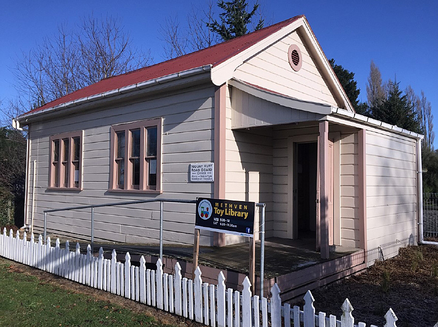
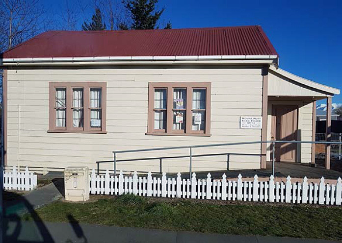
Fronting close to the western side of Main Street, at the south end of Methven, the Mount Hutt Road Board Office (Former) is a small single storeyed building constructed of timber with a gabled corrugated iron roof. Rectangular in plan, it comprises a main hall, just over ten metres long by five metres wide, with a lean-to entrance lobby on its north side. The interior has timber dado panelling and lath and plaster, and on the south wall is a timber fire surround branded with MHRB markings. A large four panelled timber cupboard is a chattel within the building.
By the time the Mount Hutt Road Board was formed, much of the roading network had already been formed, so a large part of their task was maintenance of the roads and bridges and gathering rates. A range of matters were dealt with from the Mount Hutt Road Board Office building. It served as a polling place, assessment court and general meeting venue. The board also acted as the Domain Board from 1885 until 1922 and during this time they planted many trees around the domain and cemetery in Methven and elsewhere.
After the Mount Hutt Road Board was disestablished in 1939, the building continued to be used by the community, including musical groups such as the Methven Orchestral Society, Methven Choral Society and Methven Caledonian Pipe Band. When the building was threatened with possible demolition in the late 1990s, lobbying by some members of the community led to an eventual decision that the building would be saved through shifting it some 16 metres within the same land parcel and this occurred in 2000.
List Entry Information
Status
Listed
List Entry Status
Historic Place Category 2
Access
Able to Visit
List Number
9616
Date Entered
26th September 2019
Date of Effect
16th October 2019
City/District Council
Ashburton District
Region
Canterbury Region
Extent of List Entry
Extent includes part of the land described as Pt Lot 2 DP 48204 (RT CB31F/1192), Canterbury Land District and the building known as the Mount Hutt Road Board Office (Former) thereon, and the following chattel: Cupboard. (Refer to map in Appendix 1 of the List entry report for further information).
Legal description
Pt Lot 2 DP 48204 (RT CB31F/1192), Canterbury Land District
Why is this place significant?
Cultural Significance
Cultural Significance or Value The Mount Hutt Road Board Office (Former) has cultural significance. It served as a venue and meeting point for numerous cultural groups and as such has a part to play in telling the story of the beliefs, values and behaviours of many of the citizens of Methven over time. In some cases these were temporary short term arrangements for the use of the building, as with church services for the Methodists and Presbyterians and as a place to store library books while the Methven Library was being constructed. Other cultural groups used the premises for much longer. Founded at a meeting held in the building in 1936, for 40 years the building served as the Methven Caledonian Pipe Band’s headquarters. The Methven Orchestral Society was similarly formed in the building in 1938, the Methven Choral Society began there in 1941, and from 1942 it was the venue for the Methven Citizens’ Committee meetings. Between 1939 and 1945 Red Cross parcels were packed for sending to service personnel during World War Two. Also during this period the Methven Primary School used it periodically as an alternative classroom. In the 2000s it was occupied by Methven Senior Net and since at least 2019 it has been operating as the Methven Toy Library. Social Significance or Value The Mount Hutt Road Board Office (Former) has social value. It provides a meeting space to bring people together for shared interests and activities. The social gatherings have varied over the years, changing from musically focused singing and band groups to now operating as a local toy library, open two days a week to provide educational and play equipment on loan for families of young children. The efforts of some members of the community to have the building saved through slight relocation in 2000 demonstrates the value shown for the place when it was threatened with possible demolition.
Historic Significance
Historical Significance or Value The Mount Hutt Road Board Office (Former) has historical significance. It reminds us of the central importance of roading infrastructure since nineteenth century colonial settlement. Built in 1879, the Mount Hutt Road Board Office (Former) was one of the first buildings constructed in Methven and, while at the time not uncommon in design or purpose, it is now a relatively rare survivor of what was a purpose-built stand-alone road board building. In addition to its formal road board office functions, the building has served as a meeting place for various community and cultural groups that help to tell the story of recreational and entertainment hobbies.
Physical Significance
Aesthetic Significance or Value The Mount Hutt Road Board Office (Former) has aesthetic value. Its visual appearance elicits an emotional response as an early Methven structure, especially in the context of loss of a number of other historic buildings in the town and district as a result of the Canterbury Earthquakes of 2010-11. The small size and layout of the building are evocative of the early days of colonial settlement, when many buildings would have been constructed in timber on such a scale, with its heritage paint colours adding to this effect. Archaeological Significance or Value The Mount Hutt Road Board Office (Former) has archaeological value. As one of the earliest buildings constructed in the new town of Methven in 1879, archaeological methods have the potential to provide additional information about the building and changes that have occurred to it over time. Architectural Significance or Value The Mount Hutt Road Board Office (Former) has architectural value. As an example of colonial architecture, it is vernacular in style, recognisable for its form, proportion, small scale and use of materials. The modest timber building is functional both in its appearance and means of construction. Despite being shifted slightly on the same land parcel in 2000, the building remains easily identifiable as the road board office constructed in the formative years of the town of Methven.
Why is this place Category 1 / Category 2?
Detail Of Assessed Criteria
It is considered that this place qualifies as a Category 2 historic place. It was assessed against, and found to qualify under the following criteria: a, e, j. (a) The extent to which the place reflects important or representative aspects of New Zealand history The Mount Hutt Road Board Office (Former) is a surviving purpose-built road board building, serving to demonstrate how important roads and associated infrastructure were to the country’s disparate settlements. The building reflects the importance of transport links to the development of New Zealand. As with other districts, the local road board and, later, county council had an important role as local government and was a noted employer in the district. The ongoing use of the building for community functions, right from its earliest days as a meeting point for church and other groups, bands and orchestras, and now as the Methven Toy Library, reflects the multi-purpose nature of the public asset. (e) The community association with, or public esteem for the place The Mount Hutt Road Board Office (Former) is regarded favourably as part of the fabric of the small town of Methven. It continues to have a community function, currently as the town’s Toy Library, open two days a week. The building was shifted slightly in 2000 rather than being demolished, reflecting the efforts of community members to have the building saved. (j) The importance of identifying rare types of historic places The Mount Hutt Road Board Office (Former) has some rarity value as an example of a road board building, a type that was once somewhat common and now appears to have a considerably reduced number surviving. It is not clear exactly how many road board buildings were purpose-built in the nineteenth century. Although there were over 300 road boards in the 1880s, not all would have required their own office and many operated out of other existing, or multi-purpose, buildings. There appear to be few surviving purpose-built road board buildings that date from the early era of road boards. Of those, most appear to be relatively small and constructed of timber, as is the case with the Mount Hutt Road Board Office (Former). Summary of Significance or Values The Mount Hutt Road Board Office (Former) has significance as an intact purpose-built early road board building that has had and continues to have considerable community use throughout its life. It serves to demonstrate how important roads and associated infrastructure were to the country’s disparate settlements and appears to be a relatively rare survivor of what was once a common type. Although it has been shifted slightly from its original location, it remains on the same land parcel that it was originally built and therefore largely retains its context.
Construction Professional
Name
Mr Coutts
Type
Builder
Biography
Builder of the Mount Hutt Road Board Office (Former), c. 1879 Source: List Entry report for the Mouth Hutt Road Board Office (Former), METHVEN, List No. 9616, Robyn Burgess, 4 September 2019
Construction Details
Type
Modification
Description
Brick chimney removed
Period
1950s
Start Year
1879
Type
Original Construction
Start Year
2000
Type
Relocation
Description
Moved a few metres on the same site.
Construction Materials
Timber, glass, corrugated iron
Māori history of the area The vast network of wetlands and plains of Kā Pākihi whakatekateka a Waitaha (Canterbury Plains) is inherently important to the history of its early occupation. The area was rich in food, building and medicinal resources from the forest and waterways. The rivers teamed with tuna, kōkopu, kanakana and īnaka; the wetlands were a good supply of wading birds and fibres for weaving; the berries from matai and hīnau were harvested from the forest as were kererū, kākā, kokopa, tūī and other fauna. Ara Tawhito are the traditional travel routes that Kāi Tahu whānui used in their travels throughout Te Waipounamu. Kāi Tahu whānui developed a complex series of trails throughout Te Waipounamu connecting kāika with one another and to mahika kai and other significant tribal resources. These traditional travel routes became the arteries of economic and social life and formed the relationships between people and places. Methven lies a short distance from Huirapa / Ōpuke (Mount Hutt), Te Maka Kaha (Mount Alford), Ōpīhako (Mount Winterslow) and Te Kiekie (Mount Somers). The nearby Rakaia and Hakatere rivers were known ara pounamu (pounamu trading trails) and the flatlands were travelled over constantly as Kāi Tahu whānui travelled to the interior and various mahika kai. Colonial Settlement and Roading Colonial settlement in the area began in the mid nineteenth century. By the end of 1854 applications had been made for the runs covering what is now Mid Canterbury (Ashburton District) but over the next ten years no organised road building was done. The land was under the administration of the Canterbury Provincial Government, with local matters being seen to by public spirited residents caring for their own district. In New Zealand there was little public road construction prior to the 1840s and 1850s. To begin with civilian roads were the responsibility of provincial governments. The earliest road boards were formed in the late 1850s and acted as early local authorities who could collect money to pay for road construction and maintenance. The Ashburton Road Board, constituted in 1863 by the Canterbury Provincial Government, took in the country from the main divide to the sea and from the Rangitātā River to the Rakaia River. The Board obtained contracts for clearing road lines, building roads through the thick tussock plains and making bridges over all streams and wetlands. After 1876, when the provincial government system was abolished, road boards, and later county councils which took over their role, did most road building and maintenance. When the Ashburton County Council was formed in 1876, the Ashburton District was divided into four separate Road Board districts. This division was to continue over the years as the roading network expanded and the land became more closely settled. Eventually there was a total of nine road boards in the Ashburton County. Town of Methven The town of Methven is in the Mount Hutt District, named after John Hutt, an early member of the Canterbury Association. Methven was named after early settler Robert Patton’s farm, ‘Methven’, in reference to his old hometown in Perthshire, Scotland. Methven town sections were put up for sale in June 1878. The sales pitch was for the new town to be at the centre of a ‘splendid agricultural district’ and highlighted that ‘timber, water, and also building stone are easily obtainable; and, as soon as the railway is completed Methven bids fair to be a most important and thriving town’. By the start of 1879, the town was beginning to develop. To open up a district, attract settlers and encourage development, good communications were needed, in particular good roads. Pioneer planners established road boards to plan, arrange finance, construct and maintain roads. On 23 April 1879 Methven settlers gathered at Barrhill and appointed W. de B. Compton as overseer to start works for the Mount Hutt Road Board. Mount Hutt Road Board Mount Hutt was formed as a road district in late 1877, initially as part of the South Rakaia Road Board, and for around two years met at South Rakaia before separating in March 1879. In April 1879 the members of the Mount Hutt Road Board elected were Charles Sydney Alington, Edward Chapman, Julian Jackson, William McMillan and John Pannett. In May 1879 Edward Chapman, the Chair, advertised for offers of a suitable central site for the erection of an office for their Mount Hutt Road Board. In October 1879 John Grigg of Longbeach offered five acres at Methven and that offer was accepted. Tenders were called for the erection of an office, cottage, stables and concrete tank. The plans and specifications were to be seen at the store of traders Messrs Friedlander Brothers in Ashburton but there is no mention of an architect. After much consideration and re-calling for tenders, a Mr Coutts was the successful tenderer with a price of £460. The contract was completed quickly, in time for the Board members to hold a meeting in the new road board office on 13 December 1879. The Mount Hutt Road Board Office was one of the first buildings constructed in the year the town of Methven was established. The building quickly became a place for regular meetings. A meeting of ratepayers was held on 5 January 1880 and by February 1880 an assessment court was held at the Road Board office in Methven. Other reasons for meetings ranged from the need to discuss railway matters, water races, and hopes for a doctor to be based in Methven. The Mount Hutt Road Board was noted for being strongly independent. Controversially, in late nineteenth century many of the most used roads in the Mount Hutt district were still unsatisfactory. The cause was poor drainage but stormwater drains were considered by the road board to be too expensive for ratepayers to pay for. Road-making improved over the decades but criticism continued over road maintenance and other decisions of the board. After much debate over the 1920s and 1930s, the most effective response to the widespread demand for good roads throughout the county was to transfer roadmaking to county control. For the Mount Hutt Road Board, this happened relatively late, in 1939. More than just an office building Not long after the Mount Hutt Road Board Office had been constructed, its main room was also being used by other groups. The Methodist Church circuit used it for a time for worship from 1879 or 1880, as did the Presbyterian Church from 1880. From 1880 the Methven Library stored books there until their purpose-built library was constructed in 1883. The building was regularly used as one of the polling places for the Ashburton District. From 1885 until 1922 the Mount Hutt Road Board also acted as the Domain Board, and during this time they planted many trees around the domain and cemetery in Methven and elsewhere. The Methven Orchestral Society was formed there in 1938. The Mount Hutt Road Board amalgamated with the Ashburton County Council after 50 years of operation but its building continued to be used by the community. In 1941 the Methven Choral Society was formed in the building and from 1942 the Methven Citizens’ Committee held meetings there. Between 1939 and 1945 Red Cross parcels were packed for sending to service personnel during World War Two and during the same period the building was used periodically by Methven Primary School as an alternative classroom. The Methven Caledonian Pipe Band was formed in July 1936 at a meeting held in the Road Board Offices. For 40 years, between 1957/8 and 1997, the building was used as the headquarters for the Band. Minor changes have been made to the building. In the 1950s an unsafe and unused brick chimney was removed from the south end. In the 1960s the County Council allowed the Methven Playcentre to build on the same corner part of the land parcel as the former Mount Hutt Road Board Office. With the growth of the Playcentre over the years, the site became increasingly cramped. In April 1999 the Playcentre approached the Ashburton District Council with a request to either move the Road Board Office building to the rear of the section or demolish it so that they could extend their complex. After considerable discussion and public input, a preservation committee was set up and in 2000 the building was moved slightly nearer to Main Street onto new foundations. It was moved about nine metres to the south and three metres east of where it had sat for over 120 years. From 2002 the building was occupied by the Methven Senior Net Group. It is now leased to the Toy Library.
Māori history of the area The vast network of wetlands and plains of Kā Pākihi whakatekateka a Waitaha (Canterbury Plains) is inherently important to the history of its early occupation. The area was rich in food, building and medicinal resources from the forest and waterways. The rivers teamed with tuna, kōkopu, kanakana and īnaka; the wetlands were a good supply of wading birds and fibres for weaving; the berries from matai and hīnau were harvested from the forest as were kererū, kākā, kokopa, tūī and other fauna. Ara Tawhito are the traditional travel routes that Kāi Tahu whānui used in their travels throughout Te Waipounamu. Kāi Tahu whānui developed a complex series of trails throughout Te Waipounamu connecting kāika with one another and to mahika kai and other significant tribal resources. These traditional travel routes became the arteries of economic and social life and formed the relationships between people and places. Methven lies a short distance from Huirapa / Ōpuke (Mount Hutt), Te Maka Kaha (Mount Alford), Ōpīhako (Mount Winterslow) and Te Kiekie (Mount Somers). The nearby Rakaia and Hakatere rivers were known ara pounamu (pounamu trading trails) and the flatlands were travelled over constantly as Kāi Tahu whānui travelled to the interior and various mahika kai. Colonial Settlement and Roading Colonial settlement in the area began in the mid nineteenth century. By the end of 1854 applications had been made for the runs covering what is now Mid Canterbury (Ashburton District) but over the next ten years no organised road building was done. The land was under the administration of the Canterbury Provincial Government, with local matters being seen to by public spirited residents caring for their own district. In New Zealand there was little public road construction prior to the 1840s and 1850s. To begin with civilian roads were the responsibility of provincial governments. The earliest road boards were formed in the late 1850s and acted as early local authorities who could collect money to pay for road construction and maintenance. The Ashburton Road Board, constituted in 1863 by the Canterbury Provincial Government, took in the country from the main divide to the sea and from the Rangitātā River to the Rakaia River. The Board obtained contracts for clearing road lines, building roads through the thick tussock plains and making bridges over all streams and wetlands. After 1876, when the provincial government system was abolished, road boards, and later county councils which took over their role, did most road building and maintenance. When the Ashburton County Council was formed in 1876, the Ashburton District was divided into four separate Road Board districts. This division was to continue over the years as the roading network expanded and the land became more closely settled. Eventually there was a total of nine road boards in the Ashburton County. Town of Methven The town of Methven is in the Mount Hutt District, named after John Hutt, an early member of the Canterbury Association. Methven was named after early settler Robert Patton’s farm, ‘Methven’, in reference to his old hometown in Perthshire, Scotland. Methven town sections were put up for sale in June 1878. The sales pitch was for the new town to be at the centre of a ‘splendid agricultural district’ and highlighted that ‘timber, water, and also building stone are easily obtainable; and, as soon as the railway is completed Methven bids fair to be a most important and thriving town’. By the start of 1879, the town was beginning to develop. To open up a district, attract settlers and encourage development, good communications were needed, in particular good roads. Pioneer planners established road boards to plan, arrange finance, construct and maintain roads. On 23 April 1879 Methven settlers gathered at Barrhill and appointed W. de B. Compton as overseer to start works for the Mount Hutt Road Board. Mount Hutt Road Board Mount Hutt was formed as a road district in late 1877, initially as part of the South Rakaia Road Board, and for around two years met at South Rakaia before separating in March 1879. In April 1879 the members of the Mount Hutt Road Board elected were Charles Sydney Alington, Edward Chapman, Julian Jackson, William McMillan and John Pannett. In May 1879 Edward Chapman, the Chair, advertised for offers of a suitable central site for the erection of an office for their Mount Hutt Road Board. In October 1879 John Grigg of Longbeach offered five acres at Methven and that offer was accepted. Tenders were called for the erection of an office, cottage, stables and concrete tank. The plans and specifications were to be seen at the store of traders Messrs Friedlander Brothers in Ashburton but there is no mention of an architect. After much consideration and re-calling for tenders, a Mr Coutts was the successful tenderer with a price of £460. The contract was completed quickly, in time for the Board members to hold a meeting in the new road board office on 13 December 1879. The Mount Hutt Road Board Office was one of the first buildings constructed in the year the town of Methven was established. The building quickly became a place for regular meetings. A meeting of ratepayers was held on 5 January 1880 and by February 1880 an assessment court was held at the Road Board office in Methven. Other reasons for meetings ranged from the need to discuss railway matters, water races, and hopes for a doctor to be based in Methven. The Mount Hutt Road Board was noted for being strongly independent. Controversially, in late nineteenth century many of the most used roads in the Mount Hutt district were still unsatisfactory. The cause was poor drainage but stormwater drains were considered by the road board to be too expensive for ratepayers to pay for. Road-making improved over the decades but criticism continued over road maintenance and other decisions of the board. After much debate over the 1920s and 1930s, the most effective response to the widespread demand for good roads throughout the county was to transfer roadmaking to county control. For the Mount Hutt Road Board, this happened relatively late, in 1939. More than just an office building Not long after the Mount Hutt Road Board Office had been constructed, its main room was also being used by other groups. The Methodist Church circuit used it for a time for worship from 1879 or 1880, as did the Presbyterian Church from 1880. From 1880 the Methven Library stored books there until their purpose-built library was constructed in 1883. The building was regularly used as one of the polling places for the Ashburton District. From 1885 until 1922 the Mount Hutt Road Board also acted as the Domain Board, and during this time they planted many trees around the domain and cemetery in Methven and elsewhere. The Methven Orchestral Society was formed there in 1938. The Mount Hutt Road Board amalgamated with the Ashburton County Council after 50 years of operation but its building continued to be used by the community. In 1941 the Methven Choral Society was formed in the building and from 1942 the Methven Citizens’ Committee held meetings there. Between 1939 and 1945 Red Cross parcels were packed for sending to service personnel during World War Two and during the same period the building was used periodically by Methven Primary School as an alternative classroom. The Methven Caledonian Pipe Band was formed in July 1936 at a meeting held in the Road Board Offices. For 40 years, between 1957/8 and 1997, the building was used as the headquarters for the Band. Minor changes have been made to the building. In the 1950s an unsafe and unused brick chimney was removed from the south end. In the 1960s the County Council allowed the Methven Playcentre to build on the same corner part of the land parcel as the former Mount Hutt Road Board Office. With the growth of the Playcentre over the years, the site became increasingly cramped. In April 1999 the Playcentre approached the Ashburton District Council with a request to either move the Road Board Office building to the rear of the section or demolish it so that they could extend their complex. After considerable discussion and public input, a preservation committee was set up and in 2000 the building was moved slightly nearer to Main Street onto new foundations. It was moved about nine metres to the south and three metres east of where it had sat for over 120 years. From 2002 the building was occupied by the Methven Senior Net Group. It is now leased to the Toy Library.
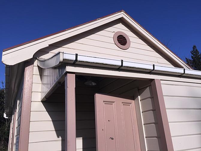
Current Description The Mount Hutt Road Board Office (Former) building sits in a fenced area close to Main Street at the south part of Methven township, just south of the T-junction with South Belt. A low picket fence fronts the east side of the building so that it is clearly visible beside the road. Utilitarian ‘child-proof’ metal fencing sits on the north and west of the building, separating it from the adjacent Playcentre on the same land parcel. At the south side is wire fencing and vegetation. There is a small area of lawn on three sides, with shingle at the rear. The Mount Hutt Road Board Office (Former) itself is a small single storeyed building constructed of a timber floor, timber framing and cladding and covered with a painted corrugated iron roof. It comprises a main hall approximately 10 metres by five metres including an entrance lobby, accessed by a ramp. The lobby has a slightly concave lean-to roof. Fenestration comprises one window on the west elevation and two triple light windows on the east elevation. A circular vent sits within the gable of the north elevation. On the interior, the main part of the office has a floor plan eight metres by five metres, with an entrance lobby of two metres by three and a half metres. The interior of the Hall is lined with 15 centimetre wide diagonal dado panelling to approximately one metre in height, above which lath and plaster completes the wall to ceiling height. The original timber fireplace surround and mantle is situated on the south wall and has MHRB branding. The timbers of interior window and door frames are rimu and kauri. A toilet is housed in a small room within the lean-to on the north elevation. In its new location, the building sits on timber piles approximately 300 mm high. A brass plaque located at the base of the wheelchair ramp states ‘Original Office of the Mt. Hutt Road Board In use from 1879 to 1939 when the Board amalgamated with Ashburton County Council’. CONTEXTUAL ANALYSIS Road Board Buildings Road boards were among the first examples of local bodies established in New Zealand and pre-dated most town administrations. In 1876, there were 215 road or highway districts in the North Island and 111 in the South Island, being 326 in total. In 1882, the Road Boards Act divided the country into 319 road districts, each governed by a road board. This reduced to 209 in 1907 and 59 in 1922, as the county councils took over road boards. Not all road boards would have had their own purpose-built offices. Of those that were built, it appears that few from the early period of road boards’ establishment in the nineteenth century survive. As at May 2019, the only known purpose-built road board building on the New Zealand Heritage List/Rārangi Kōrero (‘the List’) is the Mount Cook Road Board Building (Former), List No. 9527, Category 2 historic place, at Burkes Pass. There is a proposal for the Castlepoint Road Board Office (Former), Tinui (List No. 4012). It is possible that some buildings entered on the List were formerly road board offices. Several borough or county council offices or former offices are currently entered on the List and may have included road board functions. The Mount Hutt Road Board Building (Former) appears to be typical of other known surviving purpose-built road board buildings in that it is a comparatively small, stand-alone, timber building. A small timber building survives in poor condition on the main road to Lake Coleridge in Canterbury – this was the Lake Coleridge Road Board office from the 1880s. The former Coldstream Road Board Office has been relocated twice and is now at The Plains Vintage Railway and Historical Museum at Tinwald. In the Masterton District, the timber Castlepoint Road Board Office (Former) was constructed in 1884 and survives in its original location at 18 Manawa Road, Tinui. In comparison, the Mount Cook Road Board Building (Former) at Burkes Pass, built in 1875-6, is constructed of unreinforced concrete and was also built as accommodation – it contains seven sizeable rooms and is now a private residence. An online search of historic images for road boards suggest many were simple timber buildings, for example, the office of the Road Board at Stafford, Westland, and the Mount Roskill Road Board in Auckland. It is concluded that the Mount Hutt Road Board Office (Former) is notable as a survivor of a type of building that was once somewhat common throughout the country. It is also potentially the oldest surviving building in Methven.
Current Description The Mount Hutt Road Board Office (Former) building sits in a fenced area close to Main Street at the south part of Methven township, just south of the T-junction with South Belt. A low picket fence fronts the east side of the building so that it is clearly visible beside the road. Utilitarian ‘child-proof’ metal fencing sits on the north and west of the building, separating it from the adjacent Playcentre on the same land parcel. At the south side is wire fencing and vegetation. There is a small area of lawn on three sides, with shingle at the rear. The Mount Hutt Road Board Office (Former) itself is a small single storeyed building constructed of a timber floor, timber framing and cladding and covered with a painted corrugated iron roof. It comprises a main hall approximately 10 metres by five metres including an entrance lobby, accessed by a ramp. The lobby has a slightly concave lean-to roof. Fenestration comprises one window on the west elevation and two triple light windows on the east elevation. A circular vent sits within the gable of the north elevation. On the interior, the main part of the office has a floor plan eight metres by five metres, with an entrance lobby of two metres by three and a half metres. The interior of the Hall is lined with 15 centimetre wide diagonal dado panelling to approximately one metre in height, above which lath and plaster completes the wall to ceiling height. The original timber fireplace surround and mantle is situated on the south wall and has MHRB branding. The timbers of interior window and door frames are rimu and kauri. A toilet is housed in a small room within the lean-to on the north elevation. In its new location, the building sits on timber piles approximately 300 mm high. A brass plaque located at the base of the wheelchair ramp states ‘Original Office of the Mt. Hutt Road Board In use from 1879 to 1939 when the Board amalgamated with Ashburton County Council’. CONTEXTUAL ANALYSIS Road Board Buildings Road boards were among the first examples of local bodies established in New Zealand and pre-dated most town administrations. In 1876, there were 215 road or highway districts in the North Island and 111 in the South Island, being 326 in total. In 1882, the Road Boards Act divided the country into 319 road districts, each governed by a road board. This reduced to 209 in 1907 and 59 in 1922, as the county councils took over road boards. Not all road boards would have had their own purpose-built offices. Of those that were built, it appears that few from the early period of road boards’ establishment in the nineteenth century survive. As at May 2019, the only known purpose-built road board building on the New Zealand Heritage List/Rārangi Kōrero (‘the List’) is the Mount Cook Road Board Building (Former), List No. 9527, Category 2 historic place, at Burkes Pass. There is a proposal for the Castlepoint Road Board Office (Former), Tinui (List No. 4012). It is possible that some buildings entered on the List were formerly road board offices. Several borough or county council offices or former offices are currently entered on the List and may have included road board functions. The Mount Hutt Road Board Building (Former) appears to be typical of other known surviving purpose-built road board buildings in that it is a comparatively small, stand-alone, timber building. A small timber building survives in poor condition on the main road to Lake Coleridge in Canterbury – this was the Lake Coleridge Road Board office from the 1880s. The former Coldstream Road Board Office has been relocated twice and is now at The Plains Vintage Railway and Historical Museum at Tinwald. In the Masterton District, the timber Castlepoint Road Board Office (Former) was constructed in 1884 and survives in its original location at 18 Manawa Road, Tinui. In comparison, the Mount Cook Road Board Building (Former) at Burkes Pass, built in 1875-6, is constructed of unreinforced concrete and was also built as accommodation – it contains seven sizeable rooms and is now a private residence. An online search of historic images for road boards suggest many were simple timber buildings, for example, the office of the Road Board at Stafford, Westland, and the Mount Roskill Road Board in Auckland. It is concluded that the Mount Hutt Road Board Office (Former) is notable as a survivor of a type of building that was once somewhat common throughout the country. It is also potentially the oldest surviving building in Methven.
Historical and Associated Iwi / Hapū / Whānau
Public NZAA Number
K36/28
Completion Date
4th September 2019
Report Written By
Robyn Burgess
Information Sources
Britten, 1991
Rosemary Britten, 'Between the Wind and the Water: Ashburton County Council 1876-1989', Ashburton 1991
Scotter, 1977
Scotter, W.H, Ashburton, A History with Records of Town and Country, Ashburton Borough and County Councils, 1977
Te Ara - The Encyclopedia of New Zealand
www.TeAra.govt.nz
McCausland, 1979
McCausland, Ray, Unto the Hills: Methven & District’s Centennial 1879-1929, 1979.
Other Information
Please note that entry on the New Zealand Heritage List/Rārangi Kōrero identifies only the heritage values of the property concerned, and should not be construed as advice on the state of the property, or as a comment of its soundness or safety, including in regard to earthquake risk, safety in the event of fire, or insanitary conditions. Archaeological sites are protected by the Heritage New Zealand Pouhere Taonga Act 2014, regardless of whether they are entered on the New Zealand Heritage List/Rārangi Kōrero or not. Archaeological sites include ‘places associated with pre-1900 human activity, where there may be evidence relating to the history of New Zealand’. This List entry report should not be read as a statement on whether or not the archaeological provisions of the Act apply to the property (s) concerned. Please contact your local Heritage New Zealand office for archaeological advice.
Current Usages
Uses: Civic Facilities
Specific Usage: Hall, Community
Former Usages
General Usage: Civic Facilities
Specific Usage: Community centre
General Usage: Government
Specific Usage: Government office building
General Usage: Religion
Specific Usage: Religion - other
General Usage: Transport
Specific Usage: Road - transport - other
Location
Sign up to hear more
Get the latest heritage news, features and events delivered
straight to your inbox.
