

Rangitatau takes its name from the pa which once occupied the headland on the western side of Tarakena Bay. The site of Rangitatau pa can be seen above Tarakena Bay, on the pinnacle of the bluff west of Te Poito Stream. Poito is another pa located below Rangitatau up the valley on a low spur, above the Poito stream of the reserve. Across from the reserve is Tarakena Bay which was once a traditional place of harvest (mahinga kai) and anchourage site (taunga waka). Poito means float of a net and the name is indicative of the rituals and traditions around net fishing.
Rangitatau means “Heaven’s door” and may be a reference to the passageway into Te Whanganui a Tara or to the sky-gazing place name thematic on Te Motu Kairangi peninsula. The Rangitatau pa was established by Ngai Tara, the first grouping of Maori to settle in the Wellington area. They were led by the rangatira Tara, after whom Te Whanganui a Tara (Wellington Harbour) is named. Tuteremoana, another noted Ngai Tara rangatira lived at Rangitatau.
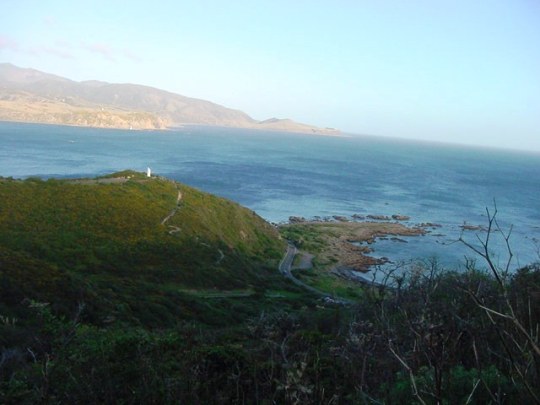
Rangitatau pa had a clear view of Raukawa Moana (the Cook Strait) and the entrance to Te Whanganui-a-Tara and protected the sea approach to Whetu Kairangi pa located above Worser Bay. Kumara were grown in the sheltered valley below, while Tarakena Bay offered the best waka landing place for some distance.
Tuteremoana, a prominent chief of Ngai Tara, is said to have lived there, the principal house being named Raukawa. Raukawa is a term referring to the leaf of the kawa tree that was used for traditional medicine and rituals such as covering the eyes with Raukawa when passing Nga Whatu (the Brothers islands in Raukawa Moana).
Rangitatau and Poito pa were destroyed by raiders from the north in 1819-20 and large numbers of people were killed, which has contributed in part to making the area tapu as a site of bloodshed.
At the turn of the century this was the best preserved pa site on Te Motu Kairangi Peninsula. Today scrub covers the sites but it is still possible to make out some of the terraces.
List Entry Information
Status
Listed
List Entry Status
Wāhi Tapu Area
Access
Able to Visit
List Number
9648
Date Entered
22nd October 2014
Date of Effect
17th November 2014
City/District Council
Wellington City
Region
Wellington Region
Extent of List Entry
Extent includes Pt Sec 1 SO 35920 (RT WN334827, NZ Gazette 1991 p.6), Sec 2 SO35920 (RT WN21A/909), Pt Sec 3 SO 35920 (NZ Gazette 1991 p.1684), Sec 56 Watts Peninsula District (RT WN21A/909, NZ Gazette 1968 p.757), Pt Moa Point Road reserve, Pt Seabed, Wellington Land District, and related wahi tapu features Rangitatau pa; Poito pa; Te Poito and Te Poti streams; and the taunga waka on Tarakena Bay that are interconnected. The boundary of this extent follows the 60 metre contour line at its northern end, then follows the ridge of the eastern spur down past the Ataturk memorial to the end of Palmer Head. It then cuts across the seabed to the opposite head of the bay directly south of Rangitatau Pa, and climbs over the road and up the spur of this pa site on its western side before rejoining the 60 metre contour line to the north.
Legal description
Sec 1 SO 35920 (RT WN334827, NZ Gazette 1991 p.6), Sec 2 SO35920 (RT WN21A/909), Pt Sec 3 SO 35920 (NZ Gazette 1991 p.1684), Sec 56 Watts Peninsula District (RT WN21A/909, NZ Gazette 1968 p.757), Moa Point Road reserve, Seabed, Wellington Land District
Statement of Wāhi Tapu / Tīpuna / Tapu Area Values
The Rangitatau area is tapu in the traditional, spiritual and ritual sense as the occupation site of significant tipuna of former iwi of the area, including Ngai Tara, and Ngati Ira. The area is also integrally connected to the layers of history and occupation of the wider Wellington region. Today, the site is under the kaitiakitanga of the iwi of Te Atiawa which holds mana whenua in the area. Rangitatau is also associated with Tuteremoana, a prominent Ngai Tara chief, and his descendants. Rangitatau and Poito in the 1800’s were besieged by a taua (war party) in which many non-combatants were killed. It is documented as a place of slaughter and pillage - a wahi parekura, tarukinga (bloodshed, slaughter) – contributing to its tapu nature. Rangitatau pa is associated with several Maori deities and is intrinsically associated with the oral histories, whakapapa, tipuna and iwi and hapu of Kurahaupo; particularly former iwi groups of the region including Ngai Tara, Ngati Ira and the descendants of those for whom Rangitatau pa was once a papakainga or turangawaewae. Its name follows a theme recurrent in Te Whanganui a Tara with the nearby Whetukairangi pa, Te Motu Kairangi peninsula, and Te Awakairangi (Hutt) river, all associated with star-gazing and great value. All of the rituals and traditions associated with pa, including mahinga kai (harvest), taunga waka (anchorage), kainga (occupation), mara kai (cultivation), urupa (burial), are associated with the Rangitatau wahi tapu area. There are two streams on the reserve: Te Poito and Te Poti. These streams were traditionally used for mahinga kai (harvest), Tohi (baptism), Kai (water supply) and noa (cleansing rituals). The fishing ground associated with the pa is Te Punga Whangai o Tuteremoana.
General Nature Of Wāhi Tapu / Tīpuna / Tapu Area
Rangitatau is part of a historic and natural landscape located on the southern coast of the Wellington region. The wahi tapu area features the pa sites Rangitatau and Poito; two streams Te Poito and Te Poti, a taunga waka down on the Tarakena Bay foreshore, and a mahinga kai (harvest site). The fishing ground associated with the pa and wider area was known as Te Punga Whangai o Tuteremoana. Rangitatau pa is located on the western headland above Tarakena Bay, west of the Te Poti Stream, at the south end of Motu Kairangi Peninsula, Wellington, and directly above the coast road. The Rangitatau headland pa site is linked to the hinterland by a narrow ridge, but naturally defended on remaining three sides by steep natural cliffs. Deeply scarped terraces are present on the southeastern side. It looks out over Tarakena Bay across the entrance to Te Whanganui-a-Tara harbour and over Raukawa Moana to Te Waipounamu. The pa site is registered as a Category 2 historic place and restricted to the boundaries of the archaeological site record (R27/55). Poito pa once stood on the eastern side below Rangitatau, looking up the valley on a low spur above the Te Poito Stream. Poito pa is covered with bush and scrub and is not recorded in the NZAA site scheme. However, it features alongside Rangitatau pa on the interpretation panel near one of the two car parks available at the site. The wahi tapu area on the northern side of Moa Point Road is a part of a belt of undeveloped land (once a military reserve ) extending all the way around the headland from the entrance of the harbour to the airport. There is a path ascending the spur directly to the East of both pa up to the Ataturk monument and beyond to a car park at the southern end of Strathmore. This eastern spur leading down to Palmer Head once showed signs of former occupation. Some of the wahi tapu area is part of recreational and historic reserves, with the pa sites featuring on a Wellington City Council heritage trail. This makes it one of the most accessible, visible and well-preserved pa site areas in Wellington. The two streams on the reserve still flow through the low-lying scrub and regenerating bush. South of the reserve, on the opposite side of the road, the Tarakena foreshore forms a sheltered harbour and a taunga waka that once serviced the Ngai Tara occupants. It still serves as a boat launching point with a concrete ramp.
Long before European settlers reached New Zealand’s shores, Wellington’s sheltered harbour had been the ancestral home to generations of Maori tribes. Evidence of early Maori settlement and cultivation can be found on sites all around the Wellington peninsula. Te Upoko o te Ika and Te Motu Kairangi Peninsula Maori mythology describes how the demigod Maui hooked a huge fish and hauled it out of the sea. His catch, Te-Ika-a-Maui (Maui’s fish), we now know as the North Island. Te Upoko-o-te-Ika (the head of the fish) is the Wellington region. The eyes of the fish are Wellington Harbour and Lake Wairarapa. Wellington’s harbour developed in the mouth of the fish which formed a lake separated from the sea by a barrier of land. This lake trapped two taniwha (sea monsters) named Ngake and Whaitaitai. Ngake didn’t like being trapped so smashed his way through to the open sea, creating the entrance to the harbour from Cook Strait. On his way out to sea Whaitaitai got stuck in shallow water as the tide went out. He remained there for centuries, only being revived by the tide washing in and out which prevented him from drying out. There was a great earthquake and Whaitaitai was uplifted, and subsequently died, becoming the present day Te Motu Kairangi / Miramar Peninsula. His wairua (spirit) left Whataitai in the form of a bird called Te Keo and flew to a nearby hill and wept. The hill was thus called ‘Tangi te Keo’, also known as Mount Victoria. Mount Victoria is now a famous Wellington landmark and a great viewing point over the harbour, city and surrounding area. Rangitatau Wahi Tapu Area The area which became the Port Nicholson block had been occupied for centuries by various Maori groups. Those in occupation immediately prior to the 1820s were Ngati Ira and related peoples who shared a common descent from early explorer Whatonga. Whatonga explored the great harbour and named it for his son Tara. Tara lived for a time at Whetukairangi pa on Te Motu Kairangi. Rangitatau, Poito, Taputeranga, Whetukairangi and other sites along the southwest coast of Te Upoko o te Ika are related. These pa overlook the harbour and across Raukawa Moana to Te Tau Ihu o te Waka (the prow of the canoe, or the Marlborough Sounds). From the 1820s, a series of migrations from the north progressively pushed out these earlier inhabitants. By the late 1830s Ngati Ira and related groups, had largely been driven out of the Port Nicholson block. By 1840, the groups holding customary rights within Port Nicholson block were Te Atiawa, Taranaki, Ngati Ruanui, Ngati Tama and Ngati Toa. These rights had been established through conquest, occupation, and use of resources. The Rangitatau wahi tapu area is associated with several Maori deities is intrinsically associated with the oral histories, whakapapa (genealogy), tipuna (ancestors) and iwi and hapu of Kurahaupo; particularly former iwi groups of the region including Ngai Tara, Ngati Ira and the descendants of those for whom Rangitatau pa was home. All the rituals associated with pa including Pakanga (battles), Mahinga Kai (harvest), Taunga waka (anchorage) Kainga (occupation) Mara kai (cultivation), Urupa (burial) and all the rituals and traditions associated with various traditional deities can be found in the Rangitatau wahi tapu area. Rangitatau wahi tapu area is a spiritual link between the past and the present, a spiritual link between the ancestors who lived there in ancient times and their descendants who do not assume kaitiakitanga (guardianship) of those lands today, but still see Rangitatau as a symbol of connection to their traditional links through whakapapa. ‘There were a number of principal Maori inhabitants of Wellington Harbour or Te Whanganui-a-Tara as it is also known in the centuries prior to European contact including Waitaha, Te Tini o Mamoe, Ngai Tara, Ngati Mamoe, Ngai Tahu, Ngati Ira and latterly Ngati Mutunga and Te Atiawa.’ “Rangitatau” literally means Heaven’s door and is perhaps a reference to the entry to the harbour. Rangitatau had a clear view of Cook Strait and the entrance to Wellington Harbour and protected the sea approach to Whetu Kairangi pa, located above Worser Bay. Kumara were grown in the sheltered valley below, while Tarakena bay offered the best taunga waka (canoe landing place) for some distance. The name of the pa is part of a thematic of other place names in Te Whanganui a Tara: Te Whetu-kairangi (“gazing on the stars”), a Ngai Tara pa in Seatoun; Te Motu Kairangi (“sky-gazing island” or “island of great value”), the peninsula; and Te Awakairangi (“sky-gazing river” or “river of great value”). The sky-gazing theme was said by Elsdon Best to originate in ‘the fact that they here saw no persons of other tribes, but dwelt in a lonely manner, the stars (whetu) of the heavens were the only things they had to gaze at every night’. Rangitatau was established by Ngai Tara, the first grouping of Maori to settle in the Wellington area. They were led by the rangatira Tara, after whom Te Whanganui-a-tara (Wellington Harbour) is named. Tuteremoana, another noted Ngai Tara rangatira lived at Rangitatau. Adkin has documented some details about Rangitatau: ‘When visited by HM Christie in 1899, traces of the site were plainly visible and charred remains of totara palisading were still in the ground. The nearby fortified village of Poito used Rangitatau as a citadel in times of stress. A large shell midden at the foot of the hill below Rangitatau citadel yielded many artefacts, and stone anvils were found beside Te Poti stream.’ Tuteremoana The following quotation is a reference of the ancestor Tuteremoana. ‘Te tama whakaete turanga rau, i titi te upoko ki te kura a rangi.’ (the young man who influenced his way on to a hundred standing places and whose head was adorned with the glow of heaven). Tuteremoana was the most famous descendant of Tara, eponymous ancestor of the Ngai Tara tribe. He lived nineteen or twenty generations ago. At his birth his grand-uncle Tuhotoariki composed a well-known oriori or song chant, "He oriori mo Tuteremoana", which has survived to this day. Tuteremoana was baptised in the Te Poti stream, and died at Rangitatau, as did his wife Wharekohu (both were taken to Kapiti island for burial). Tuhotoariki was a famous tohunga or priest of his time, and his oriori contains many spiritual teachings for his high born grand-nephew. Tuteremoana has been described as the tino ariki or high chief of the Ngai Tara, Rangitane and Ngati Awanuiarangi tribes and at one time held sway over the Hawke's Bay, Manawatu, Wairarapa, Kapiti and Wellington regions. At one time he lived at Rangitatau Pa, and a well-known fishing ground there is named Te Punga-whangai-o-Tuteremoana (the food anchorage of Tuteremoana). He was living in the Heretaunga region of Hawke's Bay until incursions from Ngati Kahungunu forced him to move further south. His father Te Aohaeretahi was buried on the sacred mountain, Kahuranaki, in Hawke's Bay. Tuteremoana later moved to the Wellington region and spent some time on Kapiti Island (full name: Te Waewae Kapiti o Tara raua ko Rangitane - the boundary between Tara and Rangitane). The peak at the northern end of Kapiti is named for him, and the burial cave at the southern end was named Te Ana-o-Wharekohu after his wife, who was buried there. Tuteremoana's own marriage to Wharekohu brought together two major genealogical lines, of the Ngai Tara and Rangitane tribes. During the incursion into Hawke's Bay by the northern Ngati Kahungunu tribe there was much fighting, and after both sides won and lost many battles a peace was made. It was affirmed by the marriage of Tuteremoana's daughter, Moeteao, to Te Whakaihirangi of Ngati Kahungunu. Moeteao gave birth to two twins, Mahanga Puhua (or Puhunga) and Mahanga Tikaro. Tuteremoana sent for them for the purpose of carrying out the tohi (baptismal) and tua (naming) rites. Drawing on manuscripts written by Te Whatahoro, Takirirangi Smith writes: ‘On arrival at Rangitatau, both children were passed through the window of Tuteremoana’s house. On the morning of the rites both children were passed out the same way. When the rites had been completed, Mahanga Puhua, the first born child, was passed back through the window, the tapu side of the house. The younger child Mahanga Tikaro was brought back through the door, an indication of lower status. From this act the mana of Mahanga Tikaro was affirmed as belonging to the eastern seaboard, and Mahanga Puhua to the western seaboard.’ This korero was used by the iwi and hapu claiming descent from the twins to identify with a rohe (tribal area) at the time: Muaupoko and Rangitane in particular identified with Mahanga Puhua as the ariki of the western seaboard, and Ngati Kahungunu identified with Mahanga Tikaro and the eastern seaboard in the wider Te Upoko o te Ika a Maui region. The following is a whakapapa of Tuteremoana: Whatonga = Hotuwaipara Tara = Te Umuroimata Pehungaiterangi = Uiratea Tiwhanaarangi = Taiakawa Hineone = Tuturangi Kotahu Hinetahurangi Te Rangitupewa = Puakina Te Rangitumaroro = Rakaukoki Tukupou = Ngauao Turia Te Aohaeretahi Tuteremoana = Wharekohu 19th Century Rangitatau Rangitatau was destroyed by raiders from the north in 1819-20 and large numbers of people were killed. It is not known if Tuteremoana was present during the raids. H.M. Christie documented some details about the destruction of the pa: ‘Coming on to the Whanganui-a-tara the raiders found the Rangitatau pa, situated across the entrance from the lighthouse, occupied by folk of Ngati-ira, Ngati-rakai, and Ngati-rangi.[…] Altogether fifty or more were slain. Poito, the fortified village of Ngati-rakai, was burned, as also were Rangitatau (the pa of Ngati-ira) and Te Kopahou, the pa of Ngati-rangi, and Ngati-hikerata. The fishermen from the places at sea saw the burning, and so paddled shoreward. When they reached the beach they found the raiders in possession, and knew by their speech that they were not members of any southern tribe, so the fishermen paddled down the coast to Orongo-rongo.’ He also identifies the raiders: ‘The northern Maoris who took part in this raid were part of the expedition of Ngati-whatua, Ngapuhi, and Ngati-toa, led by Patuone, Tuwhare , Te Rauparaha, Te Rangihaeata and other chiefs. Apparently Ngati-maru had sent warriors, for one Kaukau has his name on the casualty list above.’ The raid was thus a precursor of the future heke (migrations) of iwi such as Ngati Toa to the wider Te Upoko o te Ika region, following leaders such as Te Rauparaha and Te Rangihaeata. Adkin summarises the names of some of the dead: ‘Both [Rangitatau and Poito] were destroyed by raiders from the north 1819-20. Led by Tuwhare, the Toa killed people from the pa working in nearby kumara fields Te Urahi and Puahu of Ngati Rangi Te Wawapo of Ngati Ira, Takatua of Ngati Rakai and a number of others, including Pauata, Kopani, Te Rongarua, Puakato, Hungahunga, Koroua and Huatoki, all men. Women slain were Huirua, Te Arahe, Pukurua, Te Koki, Te Rehu, Tangiaru, Hineuhi and Tihitihi. In all some 50 died. As well as Poito and Rangitatau, the raiders destroyed Te Kopahou, the pa of Ngati Rangi and Ngati Hikerata, but there was a retaliatory raid.’ In the early 1800s, a series of migrations resulted in the settlement of Ngati Toa Rangatira (Ngati Toa), Ngati Raukawa and factions of Te Atiawa on the Kapiti Coast and Wellington area. A large migration also took place from the Taranaki region including members of Ngati Mutunga, Ngati Tama and Te Atiawa. Today, although scrub covers the sites today it is still possible to make out some of the terraces. Taranaki holds mana whenua and mana kaitiakitanga of the Rangitatau wahi tapu area.
Long before European settlers reached New Zealand’s shores, Wellington’s sheltered harbour had been the ancestral home to generations of Maori tribes. Evidence of early Maori settlement and cultivation can be found on sites all around the Wellington peninsula. Te Upoko o te Ika and Te Motu Kairangi Peninsula Maori mythology describes how the demigod Maui hooked a huge fish and hauled it out of the sea. His catch, Te-Ika-a-Maui (Maui’s fish), we now know as the North Island. Te Upoko-o-te-Ika (the head of the fish) is the Wellington region. The eyes of the fish are Wellington Harbour and Lake Wairarapa. Wellington’s harbour developed in the mouth of the fish which formed a lake separated from the sea by a barrier of land. This lake trapped two taniwha (sea monsters) named Ngake and Whaitaitai. Ngake didn’t like being trapped so smashed his way through to the open sea, creating the entrance to the harbour from Cook Strait. On his way out to sea Whaitaitai got stuck in shallow water as the tide went out. He remained there for centuries, only being revived by the tide washing in and out which prevented him from drying out. There was a great earthquake and Whaitaitai was uplifted, and subsequently died, becoming the present day Te Motu Kairangi / Miramar Peninsula. His wairua (spirit) left Whataitai in the form of a bird called Te Keo and flew to a nearby hill and wept. The hill was thus called ‘Tangi te Keo’, also known as Mount Victoria. Mount Victoria is now a famous Wellington landmark and a great viewing point over the harbour, city and surrounding area. Rangitatau Wahi Tapu Area The area which became the Port Nicholson block had been occupied for centuries by various Maori groups. Those in occupation immediately prior to the 1820s were Ngati Ira and related peoples who shared a common descent from early explorer Whatonga. Whatonga explored the great harbour and named it for his son Tara. Tara lived for a time at Whetukairangi pa on Te Motu Kairangi. Rangitatau, Poito, Taputeranga, Whetukairangi and other sites along the southwest coast of Te Upoko o te Ika are related. These pa overlook the harbour and across Raukawa Moana to Te Tau Ihu o te Waka (the prow of the canoe, or the Marlborough Sounds). From the 1820s, a series of migrations from the north progressively pushed out these earlier inhabitants. By the late 1830s Ngati Ira and related groups, had largely been driven out of the Port Nicholson block. By 1840, the groups holding customary rights within Port Nicholson block were Te Atiawa, Taranaki, Ngati Ruanui, Ngati Tama and Ngati Toa. These rights had been established through conquest, occupation, and use of resources. The Rangitatau wahi tapu area is associated with several Maori deities is intrinsically associated with the oral histories, whakapapa (genealogy), tipuna (ancestors) and iwi and hapu of Kurahaupo; particularly former iwi groups of the region including Ngai Tara, Ngati Ira and the descendants of those for whom Rangitatau pa was home. All the rituals associated with pa including Pakanga (battles), Mahinga Kai (harvest), Taunga waka (anchorage) Kainga (occupation) Mara kai (cultivation), Urupa (burial) and all the rituals and traditions associated with various traditional deities can be found in the Rangitatau wahi tapu area. Rangitatau wahi tapu area is a spiritual link between the past and the present, a spiritual link between the ancestors who lived there in ancient times and their descendants who do not assume kaitiakitanga (guardianship) of those lands today, but still see Rangitatau as a symbol of connection to their traditional links through whakapapa. ‘There were a number of principal Maori inhabitants of Wellington Harbour or Te Whanganui-a-Tara as it is also known in the centuries prior to European contact including Waitaha, Te Tini o Mamoe, Ngai Tara, Ngati Mamoe, Ngai Tahu, Ngati Ira and latterly Ngati Mutunga and Te Atiawa.’ “Rangitatau” literally means Heaven’s door and is perhaps a reference to the entry to the harbour. Rangitatau had a clear view of Cook Strait and the entrance to Wellington Harbour and protected the sea approach to Whetu Kairangi pa, located above Worser Bay. Kumara were grown in the sheltered valley below, while Tarakena bay offered the best taunga waka (canoe landing place) for some distance. The name of the pa is part of a thematic of other place names in Te Whanganui a Tara: Te Whetu-kairangi (“gazing on the stars”), a Ngai Tara pa in Seatoun; Te Motu Kairangi (“sky-gazing island” or “island of great value”), the peninsula; and Te Awakairangi (“sky-gazing river” or “river of great value”). The sky-gazing theme was said by Elsdon Best to originate in ‘the fact that they here saw no persons of other tribes, but dwelt in a lonely manner, the stars (whetu) of the heavens were the only things they had to gaze at every night’. Rangitatau was established by Ngai Tara, the first grouping of Maori to settle in the Wellington area. They were led by the rangatira Tara, after whom Te Whanganui-a-tara (Wellington Harbour) is named. Tuteremoana, another noted Ngai Tara rangatira lived at Rangitatau. Adkin has documented some details about Rangitatau: ‘When visited by HM Christie in 1899, traces of the site were plainly visible and charred remains of totara palisading were still in the ground. The nearby fortified village of Poito used Rangitatau as a citadel in times of stress. A large shell midden at the foot of the hill below Rangitatau citadel yielded many artefacts, and stone anvils were found beside Te Poti stream.’ Tuteremoana The following quotation is a reference of the ancestor Tuteremoana. ‘Te tama whakaete turanga rau, i titi te upoko ki te kura a rangi.’ (the young man who influenced his way on to a hundred standing places and whose head was adorned with the glow of heaven). Tuteremoana was the most famous descendant of Tara, eponymous ancestor of the Ngai Tara tribe. He lived nineteen or twenty generations ago. At his birth his grand-uncle Tuhotoariki composed a well-known oriori or song chant, "He oriori mo Tuteremoana", which has survived to this day. Tuteremoana was baptised in the Te Poti stream, and died at Rangitatau, as did his wife Wharekohu (both were taken to Kapiti island for burial). Tuhotoariki was a famous tohunga or priest of his time, and his oriori contains many spiritual teachings for his high born grand-nephew. Tuteremoana has been described as the tino ariki or high chief of the Ngai Tara, Rangitane and Ngati Awanuiarangi tribes and at one time held sway over the Hawke's Bay, Manawatu, Wairarapa, Kapiti and Wellington regions. At one time he lived at Rangitatau Pa, and a well-known fishing ground there is named Te Punga-whangai-o-Tuteremoana (the food anchorage of Tuteremoana). He was living in the Heretaunga region of Hawke's Bay until incursions from Ngati Kahungunu forced him to move further south. His father Te Aohaeretahi was buried on the sacred mountain, Kahuranaki, in Hawke's Bay. Tuteremoana later moved to the Wellington region and spent some time on Kapiti Island (full name: Te Waewae Kapiti o Tara raua ko Rangitane - the boundary between Tara and Rangitane). The peak at the northern end of Kapiti is named for him, and the burial cave at the southern end was named Te Ana-o-Wharekohu after his wife, who was buried there. Tuteremoana's own marriage to Wharekohu brought together two major genealogical lines, of the Ngai Tara and Rangitane tribes. During the incursion into Hawke's Bay by the northern Ngati Kahungunu tribe there was much fighting, and after both sides won and lost many battles a peace was made. It was affirmed by the marriage of Tuteremoana's daughter, Moeteao, to Te Whakaihirangi of Ngati Kahungunu. Moeteao gave birth to two twins, Mahanga Puhua (or Puhunga) and Mahanga Tikaro. Tuteremoana sent for them for the purpose of carrying out the tohi (baptismal) and tua (naming) rites. Drawing on manuscripts written by Te Whatahoro, Takirirangi Smith writes: ‘On arrival at Rangitatau, both children were passed through the window of Tuteremoana’s house. On the morning of the rites both children were passed out the same way. When the rites had been completed, Mahanga Puhua, the first born child, was passed back through the window, the tapu side of the house. The younger child Mahanga Tikaro was brought back through the door, an indication of lower status. From this act the mana of Mahanga Tikaro was affirmed as belonging to the eastern seaboard, and Mahanga Puhua to the western seaboard.’ This korero was used by the iwi and hapu claiming descent from the twins to identify with a rohe (tribal area) at the time: Muaupoko and Rangitane in particular identified with Mahanga Puhua as the ariki of the western seaboard, and Ngati Kahungunu identified with Mahanga Tikaro and the eastern seaboard in the wider Te Upoko o te Ika a Maui region. The following is a whakapapa of Tuteremoana: Whatonga = Hotuwaipara Tara = Te Umuroimata Pehungaiterangi = Uiratea Tiwhanaarangi = Taiakawa Hineone = Tuturangi Kotahu Hinetahurangi Te Rangitupewa = Puakina Te Rangitumaroro = Rakaukoki Tukupou = Ngauao Turia Te Aohaeretahi Tuteremoana = Wharekohu 19th Century Rangitatau Rangitatau was destroyed by raiders from the north in 1819-20 and large numbers of people were killed. It is not known if Tuteremoana was present during the raids. H.M. Christie documented some details about the destruction of the pa: ‘Coming on to the Whanganui-a-tara the raiders found the Rangitatau pa, situated across the entrance from the lighthouse, occupied by folk of Ngati-ira, Ngati-rakai, and Ngati-rangi.[…] Altogether fifty or more were slain. Poito, the fortified village of Ngati-rakai, was burned, as also were Rangitatau (the pa of Ngati-ira) and Te Kopahou, the pa of Ngati-rangi, and Ngati-hikerata. The fishermen from the places at sea saw the burning, and so paddled shoreward. When they reached the beach they found the raiders in possession, and knew by their speech that they were not members of any southern tribe, so the fishermen paddled down the coast to Orongo-rongo.’ He also identifies the raiders: ‘The northern Maoris who took part in this raid were part of the expedition of Ngati-whatua, Ngapuhi, and Ngati-toa, led by Patuone, Tuwhare , Te Rauparaha, Te Rangihaeata and other chiefs. Apparently Ngati-maru had sent warriors, for one Kaukau has his name on the casualty list above.’ The raid was thus a precursor of the future heke (migrations) of iwi such as Ngati Toa to the wider Te Upoko o te Ika region, following leaders such as Te Rauparaha and Te Rangihaeata. Adkin summarises the names of some of the dead: ‘Both [Rangitatau and Poito] were destroyed by raiders from the north 1819-20. Led by Tuwhare, the Toa killed people from the pa working in nearby kumara fields Te Urahi and Puahu of Ngati Rangi Te Wawapo of Ngati Ira, Takatua of Ngati Rakai and a number of others, including Pauata, Kopani, Te Rongarua, Puakato, Hungahunga, Koroua and Huatoki, all men. Women slain were Huirua, Te Arahe, Pukurua, Te Koki, Te Rehu, Tangiaru, Hineuhi and Tihitihi. In all some 50 died. As well as Poito and Rangitatau, the raiders destroyed Te Kopahou, the pa of Ngati Rangi and Ngati Hikerata, but there was a retaliatory raid.’ In the early 1800s, a series of migrations resulted in the settlement of Ngati Toa Rangatira (Ngati Toa), Ngati Raukawa and factions of Te Atiawa on the Kapiti Coast and Wellington area. A large migration also took place from the Taranaki region including members of Ngati Mutunga, Ngati Tama and Te Atiawa. Today, although scrub covers the sites today it is still possible to make out some of the terraces. Taranaki holds mana whenua and mana kaitiakitanga of the Rangitatau wahi tapu area.
Historical and Associated Iwi / Hapū / Whānau
Iwi: Taranaki
Iwi: Te Ātiawa (Wellington)
Public NZAA Number
R27/113
Completion Date
16th September 2014
Report Written By
Anthony Tipene
Information Sources
Adkin, 1959
GL Adkin, 'The Great Harbour of Tara', Wellington, 1959
Meads, M., & Grove, N. (2002)
Nga Pepeha a nga Tipuna. Victoria University Press, Wellington, N.Z.
Other Information
A fully referenced report is available from the Maori Heritage team of the National Office in Wellington. Please note that entry on the New Zealand Heritage List/Rarangi Korero identifies only the heritage values of the property concerned, and should not be construed as advice on the state of the property, or as a comment of its soundness or safety, including in regard to earthquake risk, safety in the event of fire, or insanitary conditions.
Location
Sign up to hear more
Get the latest heritage news, features and events delivered
straight to your inbox.
