

In the early 1860s, in the wake of the gold rush to Gabriel’s Gully near Lawrence, miners made their way over the high and isolated country near what is now Waipori. Some prospected in the gullies and streams and found gold in December 1861 and miners rushed the area hoping to make their fortunes. A party of Shetland Islanders found a gold-bearing quartz reef as early as March 1862. The reef became known as the Shetland Quartz Reef and was the site of the first quartz mine in Otago. Initially the miners worked by hand, crushing the stone, but when the stone became too hard the first miners abandoned the claim, not having the funds to develop the mine - quartz mining required backing and capital. The Otago Pioneer Quartz Mining and Crushing Company took over the reef and they imported a stamper mill and water wheel from Melbourne to work the reef.
As was common with quartz mines, companies came and went and restructured. Other companies operated batteries on different parts of the reef, including the Canton (started by Chinese miners) and the Victory Company. Ultimately, some 70 companies mined for quartz, in this, the earliest of Otago’s quartz mines. Quartz mining at Waipori lasted until around 1912.
The archaeological features within the Otago Pioneer Quartz area represent the range of sites characteristic of quartz mining – battery sites, shafts, water races, mullock heaps, water wheels and the like. Together they provide evidence of quartz mining as a working system where each part forms a function. Quartz crushing plants included battery houses, the batteries themselves, specialised machinery and other associated structures such as dwellings and office buildings. Water wheels, fed from water races, drove quartz crushing machinery, water pumps, lifting gear and electric generators. The recorded sites provide evidence of these systems on the ground, reflecting the changes over time – the closure and re-opening of plants, and the development of new plants. Old road or tramway alignments provide evidence of the communication and transport links that were vital to the working of these mines.
Once the goldfield was worked out, land reverted to farming, with mining sites marked by their races and machinery remnants across the landscape. In 1987, the land associated with the OPQ Complex became stewardship land under the Conservation Act, recognising its natural and historic values.
List Entry Information
Status
Listed
List Entry Status
Historic Place Category 1
Access
Private/No Public Access
List Number
9692
Date Entered
10th December 2015
Date of Effect
21st January 2016
City/District Council
Clutha District
Region
Otago Region
Extent of List Entry
Extent includes the land described as Pt Sec 99 Blk IV Waipori SD, Pt Sec 13 Blk XI Tuapeka East SD, Pt Run 51 (all Crown land, no titles) and Legal Road, Otago Land District and the archaeological sites associated with the Otago Pioneer Quartz Mine Complex thereon. (Refer to map in Appendix 1 of the List entry report for further information).
Legal description
Pt Sec 99 Blk IV Waipori SD, Pt Sec 13 Blk XI Tuapeka East SD, Pt Run 51 and Legal Road, Otago Land District.
Location Description
The sites are all located in the Otago Pioneer Quartz (OPQ) Conservation Area near Waipori. This is stewardship land, administered under the Conservation Act 1987. This OPQ Conservation Area is included in the Otago Goldfields Park, a multi-site park with a historic goldfields theme that was established by the former Department of Lands and Survey, and is now administered by the Department of Conservation.
Why is this place significant?
Historic Significance
Historical Significance or Value Otago Pioneer Quartz Mine Sites has special historical significance as the earliest quartz mining area in Otago, a herald of the quartz mining boom that spread around the province in the 1870s and 1880s. OPQ tells the story of 1860s quartz mining through to the end of quartz mining in the early years of the twentieth century. Gold mining is one of the major themes in New Zealand’s history and has had a great impact on the New Zealand landscape. Otago was one of the principal areas of mining (along with the West Coast and the Coromandel). The history of the area plays out the initial optimism of the 1860s and the beginnings of the enthusiasm for quartz, which foreshadowed the boom that was to follow in places like Bendigo in the 1870s.
Physical Significance
Archaeological Significance or Value The Otago Pioneer Quartz Mine Complex has very high archaeological significance due to the tangible evidence present depicting the full process of quartz mining from its earliest days in New Zealand. In addition, contained within its boundary are sites that illustrate almost the entire quartz mining history of Waipori – the sites represent transport, mining engineering, occupation, communication, changes in mining technology and how miners lived. The sites provide evidence of the earliest nineteenth century quartz mining technologies and systems juxtaposed with early twentieth century mining. As such they yield valuable archaeological information on changes to these technologies. Technological Significance or Value Several structures within the Otago Pioneer Quartz complex have technological significance, illustrating the technology associated with hard rock mining in the nineteenth century. The Canton Battery, although not unique, as a number of other physically and technologically comparable battery structures remain, is nevertheless a relatively rare surviving intact example of what was once a very common industrial plant, most of which have now been destroyed. The Canton water-wheel too is a rare survivor of a once common wheel type. The Victory water-wheel, although similar to several others in Otago, has several unique technological details and is probably the oldest surviving item of goldfields equipment in Otago, having been made in 1863.
Why is this place Category 1 / Category 2?
Detail Of Assessed Criteria
(a) The extent to which the place reflects important or representative aspects of New Zealand history The Otago Pioneer Quartz Mine Complex has special significance as it reflects the earliest development of hard rock quartz mining in Otago, and is contemporary with the first quartz mine in the Coromandel. OPQ represents an unbroken sequence of about fifty years of quartz mining. Quartz mining was an important industry in nineteenth century Otago and it started at Waipori, a largely forgotten goldfield. The quartz mining companies brought together the expertise, capital and technologies required to develop hard rock mining, often importing equipment and personnel from overseas goldfields, so linking with international goldfields history. The OPQ complex, with its links to Victoria, still evident in the surviving archaeological features, represents this significant aspect of goldfields history. (b) The association of the place with events, persons, or ideas of importance in New Zealand history The Otago Pioneer Quartz Mine Complex is associated with the gold rushes in nineteenth century New Zealand. Gold mining changed the economic and physical landscape of New Zealand forever and made Otago the richest province in New Zealand, and Dunedin its most wealthy city for a period. The Complex is also associated with Chinese miners, an important group of persons in New Zealand history, and their attempts at quartz mining alongside European miners, which was unusual on the goldfields. (c) The potential of the place to provide knowledge of New Zealand history Through archaeological methods the Otago Pioneer Quartz Complex has the potential to provide knowledge about the nineteenth and early twentieth century quartz mining technologies and the lives of the miners who worked there. The physical remains represent the mining systems and include the full range of mining activities – from prospecting, water management (races and dams), mining (shafts and tunnels), processing (battery sites) and transport (wagon tracks and old roads). (e) The community association with, or public esteem for the place The history of the Otago Pioneer Quartz Mine Complex is recognised by the community – both the descendants of the miners and residents of Waipori, and through special interest groups such as the Otago Goldfields Heritage Trust. It is included on the sites to visit by tourism companies, and by the Goldfields Heritage Trail. Descendants of the nineteenth century miners are holding a reunion in 2016, recognising their common heritage. The planned events include a visit to the OPQ site and the Canton battery. (f) The potential of the place for public education The Otago Pioneer Quartz Mine Complex has high interpretive value in its landscape, providing a vivid sense of what life and work would have been like for miners in this isolated and harsh environment. While there is some interpretation on site relating to the Canton Battery, there is potential for further public education through further onsite interpretation and walkways around the various mining sites. This site is very accessible and hence easily illustrates quartz mining archaeology to the public. (k) The extent to which the place forms part of a wider historical and cultural area The Otago Pioneer Quartz Mining Complex is part of the wider mining landscape of Waipori which includes other quartz mining sites as well as an extensive network of alluvial mining sites and dredging sites relating to the nineteenth century and early twentieth century gold mining at Waipori. Summary of Significance or Values The Otago Pioneer Quartz Mining Complex is the site of the first quartz mining in Otago, providing special insight into the earliest technologies associated with what would become one of Otago’s most significant industries in the later 1870s and 1880s. The archaeological sites within the Complex provide evidence of the working systems of hard rock mining at Waipori from the 1860s through to the early 1900s, and provide evidence of the full mining process. It is considered that this place qualifies as a Category 1 historic place.
Construction Details
Start Year
1862
Type
Other
Description
Otago Pioneer Quartz Mining and Crushing Company begin working the reef
Start Year
1875
Type
Modification
Description
New battery installed at OPQ Mine
Start Year
1875
Type
Modification
Description
Battery associated with Victory Mine installed
Start Year
1879
Type
Other
Description
Canton Mine established by Chinese miners
Start Year
1887
Type
Other
Description
Canton Mine reopened by Long and party
Start Year
1910
Type
Relocation
Description
Battery sold and moved to Macetown
Start Year
1910
Type
Other
Description
New Canton Gold-mining Company reopened Canton claim
Type
Other
Description
Canton Mine last worked
Period
1920s-1930s
Construction Materials
Timber, concrete, cast iron, sod, earth, stone.
Notable Features
Sites Associated with the Otago Pioneer Quartz Mine Old Road: NZAA Site Record H44/25 (previously S162/23) E 1358300 N 4918078 NZTM This is an old road or tramway alignment. It probably ran from the Otago Pioneer Quartz mine to the stamper mill. The road is 2.2 metres wide. It runs downhill between two sets of prospector’s holes. OPQ Stamper Battery Complex: NZAA Site Record H44/26 (previously S162/24) E 1358354 N 4917789 NZTM This is the site of the OPQ Company’s stamper battery. The battery was removed in the early twentieth century and re-erected near Macetown to become the Homeward Bound Battery, where it still stands today. The OPQ site consists of the large cutting into the hillside where the battery stood, and various levelled areas and building foundations. There is a large hole in front of where the stamper stood. Otago Pioneer Quartz Mining Complex Sites: NZAA Site Record H44/27 (previously S162/25) E 1358601 N 4917678 NZTM This site is marked by pieces of cast iron and wood debris scattered over an area with concrete foundations and shaft, as well as large scale workings evidenced by tailings and a reservoir, and wall mounds. The reservoir is behind a spoil heap marked by a pond at present. Large Scale Workings: NZAA Site Record H44/28 (previously S162/26) E 1358601 N 4917678 NZTM This site provides evidence of large scale workings. It includes foundation remains, tailings, iron debris and a shaft. Quartz Crusher remains: NZAA Site Record H44/29 (previously S162/27) E 1358601 N 4917678 NZTM This site includes the remains of concrete foundations with large steel bolts protruding. The foundations would have provided anchorage for machinery associated with quartz crushing. Wagon Track: NZAA Site Record H44/30 (previously S162/28) E 1358500 N 4918078 NZTM This track descends from the main Waipori-Lawrence road. It leads down to the battery site mentioned above. It travels some 350 metres and is 2.16 metres wide with two parallel ruts 600 mm wide and 230 mm deep running down each edge of the track. It runs into the Otago Pioneer Quartz gully. Mining Remains: H44/31 (previously S162/29) E 1358501 N 4917678 NZTM This site is situated in the upper western branch gully of the OPQ gully. A track 1.6 metres wide with 300 mm wide ruts leads to a stone wall and earth dam, which formed part of the mining system in the gully. There are several prospector’s holes and small water races in the gully, as well as a debris heap 10 metres long, 8 metres wide and 4 metres high at the confluence of this gully and the OPQ gully. Water Races: H44/32 (previously S162/30) E 1358501 N 4917678 NZTM This site includes three water races associated with the mining complex. Two are situated on the west bank of the Otago Pioneer Quartz gully, and one on the east bank. The western races are 200 mm deep by 400 mm wide. The eastern race is 500 mm wide at the top, narrowing to 400 mm at the bottom. It is 200 mm deep. Dwelling Remains: H44/33 (previously S162/61) E 1358500 N 4917978 NZTM This is the remains of a sod dwelling situated in the Otago Pioneer Quartz gully. Inside it measures 9.5 metres long, 4 metres wide with walls approximately 500 mm wide. Otago Pioneer Quartz Mining Battery Complex: H44/34 (previously S162/32) E 1358401 N 4917678 NZTM This site marks the remains of the Otago Pioneer Quartz Crushing Company’s 10-stamp battery. The remains include the battery site, an old road, a tramway cutting, stone walls, a water race, concrete foundations, cast iron machinery components and the remains of buildings.
Waipori (or Waipouri, as it was reported in 1880) was an area known to Maori. The lower catchment of the Waipori River and wetlands was used intensively by Maori for food gathering. Trails from the lowland areas led to the upland areas, and although forestry and gold mining probably destroyed sites, it is likely that Maori used resources in these areas. There are few recorded Maori archaeological sites in the Upper Waipori catchment. Waipori, a high and isolated locality between the Taieri Plain and Lawrence, was in the nineteenth century, the shortest route between Dunedin and the newly discovered goldfield at Gabriels Gully. In the early 1860s, this route was crowded with miners hoping to try their luck at the newly discovered goldfield. The route saw miners walk out via West Taieri, over Maungaatua into the Upper Waipori Valley, before dropping into Wetherstons. Along the way miners stopped to prospect the gullies and streams and on 17 December 1861 prospector O’Hara and his party found gold. By 20 December there were some 400 miners working the banks of the Lammerlaw Creek and its tributaries. Soon after, the population reached around 2,000 – a new town was formed. The location was so inhospitable that another township formed on level ground near the road and ford, which became Waipori (while the earlier site was known as Waipori Junction). As with other goldfields, the first miners worked with a shovel and pan, moving on to sluice boxes and cradles as they were able, and built water races to bring water to their claims. The beginnings of quartz mining Gold mining is one of the major themes in New Zealand’s history and has had a ‘great impact on New Zealand landscape.’ Central Otago and Tuapeka were two of the principal areas of mining (along with the West Coast and the Coromandel). Mining took two forms – working alluvial gravels and quartz bedrock mining. In Otago, the earliest area of quartz bedrock mining was at a quartz reef near Waipori. Quartz mining required money, men and equipment – the rock had to be mined, crushed, and treated to extract the gold. Such processing required large plant and buildings, as well as motive power such as water and steam power using coal as fuel. Both alluvial mining and quartz bedrock mining left characteristic landscape effects: alluvial mining left its logical sequence of water races, reservoirs, sluicing faces, tailings and tail races, while quartz mining left shafts and adits, mullock heaps and battery sites. At Waipori there is a conservation area where visitors can see the remains of bedrock quartz mining, as well as the ruins of the associated residences and roads. A party of Shetland Islanders found a gold bearing quartz reef at Waipori as early as March 1862. The reef became known as the Shetland Quartz Reef and was the site of the first quartz mine in Otago. The reef was ‘from two to three feet wide, and visible on the surface for seventy or eighty yards, and gold all over it, wherever we have tried.’ The Otago Witness reporter believed the reef would be ‘highly remunerative’ and that ‘we have as yet only obtained the faintest glimpse of the brilliant future of Otago.’ Initially the reef was worked by hand, but soon a water-powered, four-stamp battery was erected, with encouraging returns. The Otago Witness reported the men ‘commenced a paddock on the highest part of the reef, broke the stone as fine as they possibly could with picks, then washed with tub and cradle. They stripped twelve feet long by three feet deep, and followed the reef down, with a small shaft, about twelve feet deep, from which they got 7 ounces of gold for two weeks work. The reef then became so hard they could not get the gold out of the stone; and having no timber, with the surface water it commenced caving in; consequently, they gave it up, and shifted to another gully, which some of the parties had got a payable prospect.’ The Otago Pioneer Quartz Mining and Crushing Company (abbreviated to, and commonly referred to as ‘OPQ’) took over the reef. The company ordered a twelve stamp battery from Melbourne, powered by an overshot waterwheel. Another company, The Waipori Company, also worked the reef in 1863. OPQ: The Otago Pioneer Quartz Company The OPQ had several different owners, with a number of different batteries erected at several different sites near the reef. By 1875, the second battery had been removed for some years, but the mine was then re-opened after some years of inactivity. A new battery was built in 1875, with ten heads of revolving stamps powered by a turbine fed by a water race. The battery worked intermittently over the next twenty years. In 1889, a company prospectus was released, hoping to raise £70,000, half in cash and half in shares. Supporting documents included Otago University geologist Professor J.G. Black’s report that estimated that the reef was capable of yielding 1,000 tons of stone per week for ten years of 50 weeks, giving some 275,000 ounces of gold, predicting, after the deduction of expenses, a significant profit for shareholders. The Tuapeka Times waxed lyrical: ‘it is very doubtful if there is anything that can rival or even equal the O.P.Q. in the golden possibilities which the prospectus brings before our vision.’ In 1897, the claim, together with the nearby Canton claim, became the property of the OPQ (Waipori) Gold Mines (Limited), an English company. The new company sank a new shaft and installed a new ten-stamp battery, as well as new winding and pumping machinery. High costs stopped work by 1902, and the equipment was sold off. In 1910, the entire remaining battery was purchased and moved to Macetown, where it was named the Homeward Bound battery and there it remains. A number of batteries operated under the OPQ banner from 1862-1902. The first two were powered by water wheels, the third by a turbine, and the fourth by steam. The site on the OPQ reserve is the last 1898-1910 battery. The Canton Mine The Canton mine, close to the Waitahuna-Waipori Road, was originally taken up by a group of Chinese miners in June 1879, investing the substantial capital of £2,400. They sank a shaft, but apparently did not strike the reef and abandoned the mine. Long and party reopened the claim in 1887. They erected a water wheel and sunk a shaft, but again, the claim was abandoned. In 1896 the claim was prospected again, and in 1897, along with the OPQ claim it was acquired by the New Zealand Minerals Company, and then by the OPQ (Waipori) Gold-mines Limited. In 1910, the mine was re-opened by the New Canton Gold-mining Company. The works were pumped out and the shaft extended. In 1911-1912, the claim was purchased by R. J. Cotton. The mine was last worked in the 1920s or 1930s. The Canton mine has an intermittent history of operations from the late 1860s/early 1870s until about 1912. The remaining machinery on site is that of the final company to work the mine, the New Canton Gold-mining Company, but the battery site was probably used prior to that. The water wheel was built locally, probably sometime in the early 1900s, but it is not known at present where the battery machinery originally came from. The Victory Company The official gold field Warden’s reports first mention the Victory Company in 1883, where it is recorded as having one of three batteries that worked the area. The Tuapeka Times advertises tenders for the construction of a water race to drive a turbine for the Victory Company in February 1882, in association with the newly erected battery of the Nil Desperandum Company. The Nil Desperandum Company had been active since the mid-1870s on a lease south of the OPQ claim. By 1875, they had a four-stamp battery erected, increased to ten heads in 1882. This was probably the battery recorded in 1882 as the Victory Company’s battery. The company operated two shafts, one in Nuggety Gully and one in Pioneer Gully. The machinery was water powered. The last entry for the mine appears in 1886. Alluvial mining also continued at Waipori, with the Golden Key (later the Golden Padlock) claim being worked by sluicing and later elevating from the early 1880s until 1923. Dredging was also an important activity, over 16 dredges having worked at Waipori, mainly on the Waipori Flats. Hydro-electric generation at Waipori began after 1901, when the Waipori Falls Electric Power Company Limited was formed with the purpose of generation and sale of electricity. A few years later the Company sold out to the Dunedin City Corporation, who, after much opposition, flooded the valley with the creation of Lake Mahinerangi in 1923. Once the goldfield was worked out, land reverted to farming, with mining sites marked by their water races and machinery remnants across the landscape. In 1974, the Department of Lands and Survey purchased Waipori Station, with the aim of establishing single farm units on the low country, farming the high country and developing forestry. A comprehensive survey of historic sites was undertaken in 1977, recognising the importance of Waipori as one of Otago’s earliest goldfields. In 1987 the Department of Conservation recognised the site for its historic values. The land is designated s25 Stewardship land pursuant to the Conservation Act 1987. The history of the Otago Pioneer Quartz Mine Complex is recognised by the community. Tourism companies visit the site, and it is on the Goldfields Heritage Trail. Descendants of the nineteenth century miners at Waipori are holding a reunion in 2016, recognising their shared heritage. The planned events include a visit to the OPQ site and the Canton battery. In 2015, the Otago Pioneer Quartz Mine Complex tells the story of Otago’s earliest quartz mine in this archaeological landscape.
Waipori (or Waipouri, as it was reported in 1880) was an area known to Maori. The lower catchment of the Waipori River and wetlands was used intensively by Maori for food gathering. Trails from the lowland areas led to the upland areas, and although forestry and gold mining probably destroyed sites, it is likely that Maori used resources in these areas. There are few recorded Maori archaeological sites in the Upper Waipori catchment. Waipori, a high and isolated locality between the Taieri Plain and Lawrence, was in the nineteenth century, the shortest route between Dunedin and the newly discovered goldfield at Gabriels Gully. In the early 1860s, this route was crowded with miners hoping to try their luck at the newly discovered goldfield. The route saw miners walk out via West Taieri, over Maungaatua into the Upper Waipori Valley, before dropping into Wetherstons. Along the way miners stopped to prospect the gullies and streams and on 17 December 1861 prospector O’Hara and his party found gold. By 20 December there were some 400 miners working the banks of the Lammerlaw Creek and its tributaries. Soon after, the population reached around 2,000 – a new town was formed. The location was so inhospitable that another township formed on level ground near the road and ford, which became Waipori (while the earlier site was known as Waipori Junction). As with other goldfields, the first miners worked with a shovel and pan, moving on to sluice boxes and cradles as they were able, and built water races to bring water to their claims. The beginnings of quartz mining Gold mining is one of the major themes in New Zealand’s history and has had a ‘great impact on New Zealand landscape.’ Central Otago and Tuapeka were two of the principal areas of mining (along with the West Coast and the Coromandel). Mining took two forms – working alluvial gravels and quartz bedrock mining. In Otago, the earliest area of quartz bedrock mining was at a quartz reef near Waipori. Quartz mining required money, men and equipment – the rock had to be mined, crushed, and treated to extract the gold. Such processing required large plant and buildings, as well as motive power such as water and steam power using coal as fuel. Both alluvial mining and quartz bedrock mining left characteristic landscape effects: alluvial mining left its logical sequence of water races, reservoirs, sluicing faces, tailings and tail races, while quartz mining left shafts and adits, mullock heaps and battery sites. At Waipori there is a conservation area where visitors can see the remains of bedrock quartz mining, as well as the ruins of the associated residences and roads. A party of Shetland Islanders found a gold bearing quartz reef at Waipori as early as March 1862. The reef became known as the Shetland Quartz Reef and was the site of the first quartz mine in Otago. The reef was ‘from two to three feet wide, and visible on the surface for seventy or eighty yards, and gold all over it, wherever we have tried.’ The Otago Witness reporter believed the reef would be ‘highly remunerative’ and that ‘we have as yet only obtained the faintest glimpse of the brilliant future of Otago.’ Initially the reef was worked by hand, but soon a water-powered, four-stamp battery was erected, with encouraging returns. The Otago Witness reported the men ‘commenced a paddock on the highest part of the reef, broke the stone as fine as they possibly could with picks, then washed with tub and cradle. They stripped twelve feet long by three feet deep, and followed the reef down, with a small shaft, about twelve feet deep, from which they got 7 ounces of gold for two weeks work. The reef then became so hard they could not get the gold out of the stone; and having no timber, with the surface water it commenced caving in; consequently, they gave it up, and shifted to another gully, which some of the parties had got a payable prospect.’ The Otago Pioneer Quartz Mining and Crushing Company (abbreviated to, and commonly referred to as ‘OPQ’) took over the reef. The company ordered a twelve stamp battery from Melbourne, powered by an overshot waterwheel. Another company, The Waipori Company, also worked the reef in 1863. OPQ: The Otago Pioneer Quartz Company The OPQ had several different owners, with a number of different batteries erected at several different sites near the reef. By 1875, the second battery had been removed for some years, but the mine was then re-opened after some years of inactivity. A new battery was built in 1875, with ten heads of revolving stamps powered by a turbine fed by a water race. The battery worked intermittently over the next twenty years. In 1889, a company prospectus was released, hoping to raise £70,000, half in cash and half in shares. Supporting documents included Otago University geologist Professor J.G. Black’s report that estimated that the reef was capable of yielding 1,000 tons of stone per week for ten years of 50 weeks, giving some 275,000 ounces of gold, predicting, after the deduction of expenses, a significant profit for shareholders. The Tuapeka Times waxed lyrical: ‘it is very doubtful if there is anything that can rival or even equal the O.P.Q. in the golden possibilities which the prospectus brings before our vision.’ In 1897, the claim, together with the nearby Canton claim, became the property of the OPQ (Waipori) Gold Mines (Limited), an English company. The new company sank a new shaft and installed a new ten-stamp battery, as well as new winding and pumping machinery. High costs stopped work by 1902, and the equipment was sold off. In 1910, the entire remaining battery was purchased and moved to Macetown, where it was named the Homeward Bound battery and there it remains. A number of batteries operated under the OPQ banner from 1862-1902. The first two were powered by water wheels, the third by a turbine, and the fourth by steam. The site on the OPQ reserve is the last 1898-1910 battery. The Canton Mine The Canton mine, close to the Waitahuna-Waipori Road, was originally taken up by a group of Chinese miners in June 1879, investing the substantial capital of £2,400. They sank a shaft, but apparently did not strike the reef and abandoned the mine. Long and party reopened the claim in 1887. They erected a water wheel and sunk a shaft, but again, the claim was abandoned. In 1896 the claim was prospected again, and in 1897, along with the OPQ claim it was acquired by the New Zealand Minerals Company, and then by the OPQ (Waipori) Gold-mines Limited. In 1910, the mine was re-opened by the New Canton Gold-mining Company. The works were pumped out and the shaft extended. In 1911-1912, the claim was purchased by R. J. Cotton. The mine was last worked in the 1920s or 1930s. The Canton mine has an intermittent history of operations from the late 1860s/early 1870s until about 1912. The remaining machinery on site is that of the final company to work the mine, the New Canton Gold-mining Company, but the battery site was probably used prior to that. The water wheel was built locally, probably sometime in the early 1900s, but it is not known at present where the battery machinery originally came from. The Victory Company The official gold field Warden’s reports first mention the Victory Company in 1883, where it is recorded as having one of three batteries that worked the area. The Tuapeka Times advertises tenders for the construction of a water race to drive a turbine for the Victory Company in February 1882, in association with the newly erected battery of the Nil Desperandum Company. The Nil Desperandum Company had been active since the mid-1870s on a lease south of the OPQ claim. By 1875, they had a four-stamp battery erected, increased to ten heads in 1882. This was probably the battery recorded in 1882 as the Victory Company’s battery. The company operated two shafts, one in Nuggety Gully and one in Pioneer Gully. The machinery was water powered. The last entry for the mine appears in 1886. Alluvial mining also continued at Waipori, with the Golden Key (later the Golden Padlock) claim being worked by sluicing and later elevating from the early 1880s until 1923. Dredging was also an important activity, over 16 dredges having worked at Waipori, mainly on the Waipori Flats. Hydro-electric generation at Waipori began after 1901, when the Waipori Falls Electric Power Company Limited was formed with the purpose of generation and sale of electricity. A few years later the Company sold out to the Dunedin City Corporation, who, after much opposition, flooded the valley with the creation of Lake Mahinerangi in 1923. Once the goldfield was worked out, land reverted to farming, with mining sites marked by their water races and machinery remnants across the landscape. In 1974, the Department of Lands and Survey purchased Waipori Station, with the aim of establishing single farm units on the low country, farming the high country and developing forestry. A comprehensive survey of historic sites was undertaken in 1977, recognising the importance of Waipori as one of Otago’s earliest goldfields. In 1987 the Department of Conservation recognised the site for its historic values. The land is designated s25 Stewardship land pursuant to the Conservation Act 1987. The history of the Otago Pioneer Quartz Mine Complex is recognised by the community. Tourism companies visit the site, and it is on the Goldfields Heritage Trail. Descendants of the nineteenth century miners at Waipori are holding a reunion in 2016, recognising their shared heritage. The planned events include a visit to the OPQ site and the Canton battery. In 2015, the Otago Pioneer Quartz Mine Complex tells the story of Otago’s earliest quartz mine in this archaeological landscape.
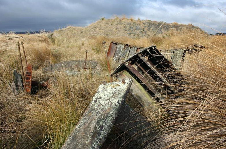
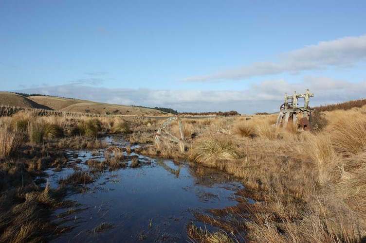
Construction Professionals Victory Water Wheel: AK Smith, Carlton Foundry, Melbourne - manufacturer Current Description Setting Waipori was a scattered mining district in the nineteenth century. It is fourteen miles from Lawrence and twenty-five miles from Outram. As mining declined, farming took over, with much of the area cleared for farmland or planted in forestry. The landscape is dominated by Lake Mahinerangi, created in 1923 as part of a hydropower scheme. In 2015, the land surrounding the conservation area is farmed. The Otago Pioneer Quartz Mine Complex is located in an area where access is reasonably easy for visitors. The Canton Battery in particular is only a two minute walk from the Waitahuna-Waipori Road, where a good impression of the conditions facing the miners can be appreciated. The battery and water wheels are located in an open, windswept landscape, which can be extremely cold and inhospitable in bad weather. Even on a fine day, the exposed location can be appreciated by visitors. The sites have high interpretative value. Features The archaeological features within the Otago Pioneer Quartz Reserve represent the range of sites characteristic of quartz mining – battery sites, shafts, water races, debris piles, water wheels and the like. Together they provide evidence of quartz mining as a working system where each part forms a function. Quartz crushing plants included battery houses, the batteries themselves, specialised machinery and other associated structures such as dwellings and office buildings. Water wheels, fed from water races, drove quartz crushing machinery, water pumps, lifting gear and electric generators. The recorded sites provide evidence of these systems on the ground, reflecting the changes over time – the closure and re-opening of plants, and the development of new plants. Old road or tramway alignments provide evidence of the communication and transport links that were vital to the working of these mines. The mines used heavy machinery and the transportation of ore that needed to be moved to and from the mine sites. The Pioneer Stream area includes some very early sites, with the Otago Pioneer Quartz Reef (first known as the Shetland Reef) reported the first auriferous quartz reef to be found in Otago. The area, of some 40 hectares includes the Canton, Otago Pioneer Quartz Crushing Company and the Victory mines. A large levelled area probably once contained the buildings associated with the Otago Pioneer Quartz Company’s operations. The sites associated with OPQ were recorded in 1979 as sites S162/23-S162/33 inclusive. Sites include part of the OPQ water race and associated reservoirs, spoil heaps and substantial concrete foundations. An old wagon track provides evidence of transport links. There are also remains of stone walled and sod dwellings, as well as numerous prospector’s holes, mine tunnels, and drives. Close to the Victory wheel are the remains of the Bennett-Shire hut, named for the early gold mining families that occupied it. Nearby, on the ridge at the end of the OPQ gully is a sod reservoir, which would have provided water storage for powering the battery. The Canton complex is east of Waipori to Waitahuna (Mitchells Flat) road where it crosses Pioneer Stream. Vincent considers the Canton site a good example of ‘articulated infrastructure’ – the site includes the water wheel, as well as the mine and quartz crushing battery that formed an integrated mining operation. The site of the Victory water wheel is at the edge of Mitchells Flat, near the mouth of OPQ Gully. Several water races run along the hill and sides of the gully. A large pile of tailings lie to the south east of the wheel. To the north east are scattered metal items. The wheel itself lies on the ground. The wheel is 49 ½ inches (1.26 metres) wide, with a diameter of around 25 feet (7.62 metres). The shroud is cast iron, cast in twelve sections to each side. There are 60 buckets made of sheet iron. The sole is timber. The hub is cast iron, and carried twelve timber spokes on each side. The legend embossed on the wheel ‘A.K. SMITH. CE CARLTON FOUNDRY MELBOURNE 1863’ suggests that it is most likely that this is the wheel originally used by the OPQ Company for their second battery. The Canton mine and battery site are marked by a notice erected by the Otago Goldfields Park. The Canton Battery is located on the south side of Mitchell’s Flat, close to the Waitahuna-Waipori Road (Mitchell’s Flat Road), at the foot of a slope beside Pioneer Stream. The framework for the ten-stamp battery stands, but only five stamps and their mortar box were ever installed. Beside the stampers is the concrete bed-plate for the steam engine that drove the mill. The gear wheel on the camshaft is still attached. A short distance from the mill is the wooden water wheel used to drive the pump for the shaft. The Canton Battery is a good example of a small battery built from parts recycled from earlier machines. The date of manufacture of the Canton machinery is not known, but the design technology is typical of the late 1860s and 1870s. Its use of a ten stamp camshaft in a five stamp mill is similar to the Young Australian Battery (NZAA Site Record F42/25), which was also relocated several times in its life. The Canton Battery is also a good surviving example of the trestle-frame form of construction. The Canton water wheel is half buried/submerged, in its original position, on the edge of the Pioneer Stream, directly opposite the probable mine shaft location. The wheel was constructed from kauri timber. The wheel was 10 feet 6 inches in diameter (3.15 metres), 38 inches wide (965 millimetres (mm)), and of wooden (kauri) construction. The cast iron hubs are each 2 feet (610 mm) in diameter across the spoke mounts, and each carried eight 3.75 inch by 2.75 inch (95 by 70 mm) spokes. The shroud was 9 inches deep (230 mm), of 1.25 inch (30 mm) thick timber, butt jointed at each spoke, secured at the joints by 9 inch x 4 inch (230 by 100 mm) steel plates. The 32 buckets were simply formed by flat 1 inch (25 mm) boards, set into 0.5 inch (12.7 mm) deep grooves in the shroud, at an angle of 45 degrees to the tangent. Long through-bolts kept the two sides of the wheel together. The vertical support timbers for the wheel, each 6 inches (150 mm) square with tenoned ends are still in situ in the ground, but the horizontal bearers are gone. Two other vertical supports, set at an angle towards each other, are located 34 inches (865 mm) to the east of the timbers on the east side of the wheel, 25 inches (635 mm) apart (i.e. each 12.5 inches from the centre line of the wheel). These probably held the drive from the wheel, which was probably through the shaft, although no transmission elements survive to clarify the picture. The wheel was overshot, supplied with water by fluming from a race on the hillside behind. The Canton Water Wheel in 2015 is in very poor condition, with only four spokes and part of the shroud still standing. It is likely that the below-ground section of the wheel, which is waterlogged all year round, is still intact. The battery almost certainly has a complex history. It appears now as a five stamp mill, but has part of the framework and the camshaft length necessary for a ten stamp mill. Examination of the camshaft showed signs of hammering around the keys securing the cams on the used end, but no similar damage on the empty end. Thus, it would appear that despite its length, it is probable that the camshaft has never carried it full potential load of ten cams. It is most likely that the battery was erected in its present form on this site, using second-hand parts brought from elsewhere. This was a common goldfields practice, and several surviving batteries are known to have been used on several sites (for example, the Golden Gully Battery at Serpentine, NZAA Site Record H42/2). Comparative Analysis Although the sites at the Otago Pioneer Quartz Mine Complex are not technologically unique, they have special significance as the earliest quartz mining sites in Otago. They are contemporary with the first quartz mine in the Coromandel. Alluvial gold was first discovered in the Coromandel in the 1850s, and the area was declared a goldfield in 1862 after the discovery of gold-bearing quartz. Stamper battery technology was imported by miners and mining engineers coming to New Zealand from the goldfields of Victoria and California. The sites at OPQ provide national and international links with the histories and technologies. Other Otago sites associated with quartz mining on the New Zealand Heritage List include Bendigo Quartz Reefs Historic Area (List Entry No. 9097), Bullendale Hydro Electric Dynamo and Mining Site (List Entry No. 5601, Category 1), Adams Gully Gold Battery Complex (List Entry No. 5616, Category 2) and the Young Australian Company Water Wheel (List Entry No. 342, Category 1). Like Bendigo Quartz Reefs Historic Area, the Otago Pioneer Quartz Mine Complex shows a range of sites, but those at OPQ are earlier than Bendigo and represent the beginnings of this industry, though they are not as dramatic. The Adams Gully Gold Battery Complex and the Young Australian Company Water Wheel are related sites, representing quartz mining on the Carrick Range in Otago. Again OPQ is earlier and represents the complete mining system associated with hard rock mining at Waipori. Others include the Invincible Mine Site near Glenorchy (List Entry No. 5603, Category 2, and associated buddle) dating from the 1880s. The Victory Water Wheel is ‘almost certainly the last surviving element of the 1863 Otago Quartz Mining Company’s battery,’ – the second stamp mill in Otago. The physical evidence – embossing on the wheel states its Melbourne origin and 1863 date of manufacture – indicates that it is ‘probably the oldest item of goldfields equipment in Otago and possibly New Zealand. It is direct physical evidence of the importation of machinery and technology from Melbourne from the early days of the New Zealand gold rushes, and therefore represents the ‘genesis of hard rock mining in southern New Zealand, and is historically very significant.’ The Nizhny Tagil Charter for the Industrial Heritage singles out such early or pioneering examples of industrial machinery as being of especial significance. There are many sites associated with quartz mining included on the New Zealand Heritage List. In the Thames/Coromandel area these include battery foundations (List Entry No. 4602, Category 2) dating from 1898 and managed by the Department of Conservation, and the Old Golden Crown Battery Building (List Entry No. 4643, Category 2), dating from around 1880. The restored Government Battery dating from 1897 at Coromandel is a Category 1 historic place (List Entry No. 130). This battery does not represent the early period of quartz mining. On the West Coast, the Big River Quartz Mine (List Entry No. 7762, Category 1) is one of the most complete quartz mining sites, but again it dates from the 1880s.
Construction Professionals Victory Water Wheel: AK Smith, Carlton Foundry, Melbourne - manufacturer Current Description Setting Waipori was a scattered mining district in the nineteenth century. It is fourteen miles from Lawrence and twenty-five miles from Outram. As mining declined, farming took over, with much of the area cleared for farmland or planted in forestry. The landscape is dominated by Lake Mahinerangi, created in 1923 as part of a hydropower scheme. In 2015, the land surrounding the conservation area is farmed. The Otago Pioneer Quartz Mine Complex is located in an area where access is reasonably easy for visitors. The Canton Battery in particular is only a two minute walk from the Waitahuna-Waipori Road, where a good impression of the conditions facing the miners can be appreciated. The battery and water wheels are located in an open, windswept landscape, which can be extremely cold and inhospitable in bad weather. Even on a fine day, the exposed location can be appreciated by visitors. The sites have high interpretative value. Features The archaeological features within the Otago Pioneer Quartz Reserve represent the range of sites characteristic of quartz mining – battery sites, shafts, water races, debris piles, water wheels and the like. Together they provide evidence of quartz mining as a working system where each part forms a function. Quartz crushing plants included battery houses, the batteries themselves, specialised machinery and other associated structures such as dwellings and office buildings. Water wheels, fed from water races, drove quartz crushing machinery, water pumps, lifting gear and electric generators. The recorded sites provide evidence of these systems on the ground, reflecting the changes over time – the closure and re-opening of plants, and the development of new plants. Old road or tramway alignments provide evidence of the communication and transport links that were vital to the working of these mines. The mines used heavy machinery and the transportation of ore that needed to be moved to and from the mine sites. The Pioneer Stream area includes some very early sites, with the Otago Pioneer Quartz Reef (first known as the Shetland Reef) reported the first auriferous quartz reef to be found in Otago. The area, of some 40 hectares includes the Canton, Otago Pioneer Quartz Crushing Company and the Victory mines. A large levelled area probably once contained the buildings associated with the Otago Pioneer Quartz Company’s operations. The sites associated with OPQ were recorded in 1979 as sites S162/23-S162/33 inclusive. Sites include part of the OPQ water race and associated reservoirs, spoil heaps and substantial concrete foundations. An old wagon track provides evidence of transport links. There are also remains of stone walled and sod dwellings, as well as numerous prospector’s holes, mine tunnels, and drives. Close to the Victory wheel are the remains of the Bennett-Shire hut, named for the early gold mining families that occupied it. Nearby, on the ridge at the end of the OPQ gully is a sod reservoir, which would have provided water storage for powering the battery. The Canton complex is east of Waipori to Waitahuna (Mitchells Flat) road where it crosses Pioneer Stream. Vincent considers the Canton site a good example of ‘articulated infrastructure’ – the site includes the water wheel, as well as the mine and quartz crushing battery that formed an integrated mining operation. The site of the Victory water wheel is at the edge of Mitchells Flat, near the mouth of OPQ Gully. Several water races run along the hill and sides of the gully. A large pile of tailings lie to the south east of the wheel. To the north east are scattered metal items. The wheel itself lies on the ground. The wheel is 49 ½ inches (1.26 metres) wide, with a diameter of around 25 feet (7.62 metres). The shroud is cast iron, cast in twelve sections to each side. There are 60 buckets made of sheet iron. The sole is timber. The hub is cast iron, and carried twelve timber spokes on each side. The legend embossed on the wheel ‘A.K. SMITH. CE CARLTON FOUNDRY MELBOURNE 1863’ suggests that it is most likely that this is the wheel originally used by the OPQ Company for their second battery. The Canton mine and battery site are marked by a notice erected by the Otago Goldfields Park. The Canton Battery is located on the south side of Mitchell’s Flat, close to the Waitahuna-Waipori Road (Mitchell’s Flat Road), at the foot of a slope beside Pioneer Stream. The framework for the ten-stamp battery stands, but only five stamps and their mortar box were ever installed. Beside the stampers is the concrete bed-plate for the steam engine that drove the mill. The gear wheel on the camshaft is still attached. A short distance from the mill is the wooden water wheel used to drive the pump for the shaft. The Canton Battery is a good example of a small battery built from parts recycled from earlier machines. The date of manufacture of the Canton machinery is not known, but the design technology is typical of the late 1860s and 1870s. Its use of a ten stamp camshaft in a five stamp mill is similar to the Young Australian Battery (NZAA Site Record F42/25), which was also relocated several times in its life. The Canton Battery is also a good surviving example of the trestle-frame form of construction. The Canton water wheel is half buried/submerged, in its original position, on the edge of the Pioneer Stream, directly opposite the probable mine shaft location. The wheel was constructed from kauri timber. The wheel was 10 feet 6 inches in diameter (3.15 metres), 38 inches wide (965 millimetres (mm)), and of wooden (kauri) construction. The cast iron hubs are each 2 feet (610 mm) in diameter across the spoke mounts, and each carried eight 3.75 inch by 2.75 inch (95 by 70 mm) spokes. The shroud was 9 inches deep (230 mm), of 1.25 inch (30 mm) thick timber, butt jointed at each spoke, secured at the joints by 9 inch x 4 inch (230 by 100 mm) steel plates. The 32 buckets were simply formed by flat 1 inch (25 mm) boards, set into 0.5 inch (12.7 mm) deep grooves in the shroud, at an angle of 45 degrees to the tangent. Long through-bolts kept the two sides of the wheel together. The vertical support timbers for the wheel, each 6 inches (150 mm) square with tenoned ends are still in situ in the ground, but the horizontal bearers are gone. Two other vertical supports, set at an angle towards each other, are located 34 inches (865 mm) to the east of the timbers on the east side of the wheel, 25 inches (635 mm) apart (i.e. each 12.5 inches from the centre line of the wheel). These probably held the drive from the wheel, which was probably through the shaft, although no transmission elements survive to clarify the picture. The wheel was overshot, supplied with water by fluming from a race on the hillside behind. The Canton Water Wheel in 2015 is in very poor condition, with only four spokes and part of the shroud still standing. It is likely that the below-ground section of the wheel, which is waterlogged all year round, is still intact. The battery almost certainly has a complex history. It appears now as a five stamp mill, but has part of the framework and the camshaft length necessary for a ten stamp mill. Examination of the camshaft showed signs of hammering around the keys securing the cams on the used end, but no similar damage on the empty end. Thus, it would appear that despite its length, it is probable that the camshaft has never carried it full potential load of ten cams. It is most likely that the battery was erected in its present form on this site, using second-hand parts brought from elsewhere. This was a common goldfields practice, and several surviving batteries are known to have been used on several sites (for example, the Golden Gully Battery at Serpentine, NZAA Site Record H42/2). Comparative Analysis Although the sites at the Otago Pioneer Quartz Mine Complex are not technologically unique, they have special significance as the earliest quartz mining sites in Otago. They are contemporary with the first quartz mine in the Coromandel. Alluvial gold was first discovered in the Coromandel in the 1850s, and the area was declared a goldfield in 1862 after the discovery of gold-bearing quartz. Stamper battery technology was imported by miners and mining engineers coming to New Zealand from the goldfields of Victoria and California. The sites at OPQ provide national and international links with the histories and technologies. Other Otago sites associated with quartz mining on the New Zealand Heritage List include Bendigo Quartz Reefs Historic Area (List Entry No. 9097), Bullendale Hydro Electric Dynamo and Mining Site (List Entry No. 5601, Category 1), Adams Gully Gold Battery Complex (List Entry No. 5616, Category 2) and the Young Australian Company Water Wheel (List Entry No. 342, Category 1). Like Bendigo Quartz Reefs Historic Area, the Otago Pioneer Quartz Mine Complex shows a range of sites, but those at OPQ are earlier than Bendigo and represent the beginnings of this industry, though they are not as dramatic. The Adams Gully Gold Battery Complex and the Young Australian Company Water Wheel are related sites, representing quartz mining on the Carrick Range in Otago. Again OPQ is earlier and represents the complete mining system associated with hard rock mining at Waipori. Others include the Invincible Mine Site near Glenorchy (List Entry No. 5603, Category 2, and associated buddle) dating from the 1880s. The Victory Water Wheel is ‘almost certainly the last surviving element of the 1863 Otago Quartz Mining Company’s battery,’ – the second stamp mill in Otago. The physical evidence – embossing on the wheel states its Melbourne origin and 1863 date of manufacture – indicates that it is ‘probably the oldest item of goldfields equipment in Otago and possibly New Zealand. It is direct physical evidence of the importation of machinery and technology from Melbourne from the early days of the New Zealand gold rushes, and therefore represents the ‘genesis of hard rock mining in southern New Zealand, and is historically very significant.’ The Nizhny Tagil Charter for the Industrial Heritage singles out such early or pioneering examples of industrial machinery as being of especial significance. There are many sites associated with quartz mining included on the New Zealand Heritage List. In the Thames/Coromandel area these include battery foundations (List Entry No. 4602, Category 2) dating from 1898 and managed by the Department of Conservation, and the Old Golden Crown Battery Building (List Entry No. 4643, Category 2), dating from around 1880. The restored Government Battery dating from 1897 at Coromandel is a Category 1 historic place (List Entry No. 130). This battery does not represent the early period of quartz mining. On the West Coast, the Big River Quartz Mine (List Entry No. 7762, Category 1) is one of the most complete quartz mining sites, but again it dates from the 1880s.
Historical and Associated Iwi / Hapū / Whānau
Public NZAA Number
H44/1029
Completion Date
17th November 2015
Report Written By
Peter Petchey and Heather Bauchop
Information Sources
Easdale and Jacomb, 1980
Easdale, S. and C. Jacomb, ‘A Review of the History and Archaeology of O.P.Q. and Pioneer Stream Historic Reserves, Waipori, Otago’, Report to Department of Lands and Survey, Dunedin (c. 1980).
Petchey, 2015
Petchey, P. G., ‘Conservation Plan: Canton Battery & Water Wheel Victory Water Wheel O.P.Q. Conservation Area (Otago Goldfields Park) May 2015 (Update of Plan dated May 1995)’, Southern Archæology Ltd. for Department of Conservation Coastal Otago District.
Petchey, 2013
Petchey, P.G., ‘The Archaeology of the New Zealand Stamp Mill’, PhD Thesis, Department of Anthropology and Archaeology, University of Otago, 2013.
Vincent, 1979
Vincent, B. A., ‘Waipori Site Survey’, (Two volumes) Report to the New Zealand Historic Places Trust, Dunedin, 1979.
Other Information
A fully referenced New Zealand Heritage List report is available on request from the Otago Southland Area Office of Heritage New Zealand. Please note that entry on the New Zealand Heritage List/Rārangi Kōrero identifies only the heritage values of the property concerned, and should not be construed as advice on the state of the property, or as a comment of its soundness or safety, including in regard to earthquake risk, safety in the event of fire, or insanitary conditions.
Current Usages
Uses: Civic Facilities
Specific Usage: Historic or recreation reserve
Uses: Cultural Landscape
Specific Usage: Industrial/mining landscape
Former Usages
General Usage: Mining
Specific Usage: Alluvial Workings
General Usage: Mining
Specific Usage: Battery/Crusher
General Usage: Mining
Specific Usage: Mine - Adit
General Usage: Mining
Specific Usage: Mine - Shaft
General Usage: Mining
Specific Usage: Mine buildings
General Usage: Mining
Specific Usage: Mine machinery
General Usage: Mining
Specific Usage: Mine reservoir/ dam
General Usage: Mining
Specific Usage: Mine road/ track
General Usage: Mining
Specific Usage: Mine Tailings
General Usage: Mining
Specific Usage: Mine Water Race/ Water Race cuttings/tunnels etc
General Usage: Mining
Specific Usage: Mullock heap
General Usage: Mining
Specific Usage: Water Wheel
Location
Sign up to hear more
Get the latest heritage news, features and events delivered
straight to your inbox.
