

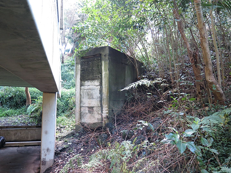
Te Pou Hawaiki was a place of sanctity and ritual from an early stage in New Zealand’s history. Soil from the ancestral homeland of Hawaiki was placed on the maunga by early arrivals to Tāmaki, and it also contained a pou or pillar where rituals were reportedly performed. In the late nineteenth and early twentieth centuries, the maunga was largely destroyed by quarrying, after which the land became part of the grounds of Auckland Teachers’ Training College. During the Second World War, the college was requisitioned as the Northern Districts Combined Headquarters – one of four complexes across the country reflecting a new military system of decentralised tactical command combining Army, Navy and Air Force personnel. Its central focus was a Combined Operations Centre in the main college building. Initial support structures included two emergency telephone exchanges and a small shelter in the quarry.
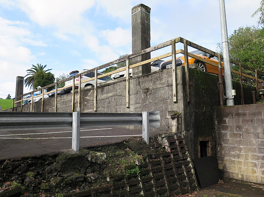
The Northern Districts Combined Headquarters Bunker was erected as an underground facility to house the Combined Operations Centre in the event of direct attack. Due to northern New Zealand’s proximity to the Pacific conflict, it was the first of its type to be started nationally and the only one to be substantially completed. Built in the base of the quarry, the rectangular, two-storey structure had a flat roof, covered by scoria for protection and concealment. Internally, it contained large columns to allow future flexibility of function, a mezzanine to enable information on plotting tables to be viewed from above, and a variety of spaces connected with essential command functions. A highly specialised structure, initial plans were provided by noted engineer, W. L. Newnham – director of fortifications and works, and president of the New Zealand Institute of Engineers in 1945-6. Its design was also influenced by officers who had knowledge of such buildings in Britain, and New Zealand airmen with experience in Malaya.
The building was almost entirely completed and fitted out when work stopped towards the end of 1943, directly reflecting improvements in the war situation. It subsequently functioned as the Combined Operations Centre’s telephone exchange, demonstrating the importance of secure communications in military command. Remaining in use as an exchange until the end of the war, it was then employed for storing up to 37,000 gas masks and refurbished for combined services training in the mid-1950s. The building’s use as a major civil defence headquarters in New Zealand’s largest city between 1966 and 1975 similarly demonstrates ongoing concerns about public security during the Cold War, and the development of a ‘bunker’ mentality following the international development of intercontinental ballistic missiles. In the 1980s, its interior was damaged by fire.
In early 2019, the bunker and associated underground structures were vacant.

List Entry Information
Status
Listed
List Entry Status
Historic Place Category 1
Access
Private/No Public Access
List Number
9747
Date Entered
22nd August 2019
Date of Effect
11th September 2019
City/District Council
Auckland Council
Region
Auckland Council
Extent of List Entry
Extent includes part of the land described as Sec 3 SO 490837 (RT 854670), North Auckland Land District, and the buildings known as and associated with Northern Districts Combined Headquarters Bunker thereon. (Refer to map in Appendix 1 of the List entry report for further information).
Legal description
Sec 3 SO 490837 (RT 854670), North Auckland Land District
Location Description
Additional Location Information NZTM Easting: 1757515.0 NZTM Northing: 5916696.5 (approximate centre of bunker)
Why is this place significant?
Cultural Significance
Spiritual Significance or Value The place has spiritual significance as part of the site of Te Pou Hawaiki, a former maunga of considerable sanctity and ritual to early ancestral Māori and subsequent peoples. Although the maunga was largely removed by quarrying in the late nineteenth and early twentieth centuries, the place retains strong intangible values of importance to tangata whenua that are linked with the early placement of soil from the ancestral homeland of Hawaiki on the maunga; subsequent use for performing rituals prior to major hunting and fishing expeditions; and possibly also later use as a pā known as Ōwhatihue.
Historic Significance
Historical Significance or Value The place has historical significance for its associations with the defence of New Zealand in the Second World War, particularly preparations against invasion following Japan’s entry into the conflict. It is strongly connected with the emergence of a new system for dealing with this threat through the creation of regional Combined Headquarters. It is especially linked with attempts to provide protection for such facilities through the provision of underground buildings. The main bunker, intended for Combined Operations Centre use, has close connections with the noted New Zealand engineer, William Langston Newnham. Through its design, it also has associations with New Zealand forces with experience in Malaya, and experts with knowledge of British underground facilities – reflecting New Zealand’s global experiences and alliances in the Second World War. The place is historically significant for its connections with New Zealand’s changing situation during the war. Employed as the Combined Operations Centre telephone exchange between 1943 and 1945, its use for communications connected with overseas troop deployments reflects the extent to which defensive approaches had been converted into those linked with activity in the Pacific. The place is also historically significant for its connections with subsequent post-war insecurity, being used as long-term storage for a large number of gas masks. It is particularly notable as Auckland’s main civil defence centre at Sub-Region and Area level during a period of concern about nuclear warfare. The place is also historically significant for its associations with successive peoples prior to European arrival as part of the wide site of Te Pou Hawaiki and Ōwhatihue, including early ancestral Māori, Te Waiōhua and Ngāti Whātua o Ōrākei. The place also has historical value for its connections with quarrying by local government bodies during the late nineteenth and early twentieth centuries, a significant activity in Auckland reflecting the importance of volcanic scoria for road construction and other use.
Physical Significance
Archaeological Significance or Value The place has archaeological significance for its ability to provide information about the construction and use of military facilities connected with the defence of New Zealand during the Second World War (1939-45). It has particular value for its capacity to supply knowledge about the creation and use of underground facilities linked with protection and concealment from bombing or shelling – closely linked with concerns about invasion after the Japanese bombing of Pearl Harbour in late 1941. The site might also contain evidence of late nineteenth and early twentieth century quarrying and scoria extraction techniques. Quarrying formed an important industrial enterprise in late nineteenth- and early twentieth-century Auckland. The eastern part of the site may retain limited deposits linked with Te Pou Hawaiki and possibly a subsequent pā known as Ōwhatihue.
Why is this place Category 1 / Category 2?
Detail Of Assessed Criteria
(a) The extent to which the place reflects important or representative aspects of New Zealand history The place has special significance for the extent to which it reflects concerns about invasion during the Second World War, and the particular vulnerability of northern New Zealand. It demonstrates new approaches to counter this threat, influenced by British military ideas. It particularly reflects the planning and creation of underground facilities for regional Combined Operations Centres – the nerve centres for tactical response – in which operational coordination between the Army, Navy and Air Force could occur in the event of attack. The place incorporates the first underground Combined Operations Centre in the country to be started and the only one to be at least partly used for its original purpose. The subsequent history of the place, and notably the bunker, also directly reflects the extent to which fear of attack subsequently receded. The place is also important for demonstrating post-war concerns about public safety, including through conversion of the main bunker to a civil defence centre in the 1960s and 1970s. Serving the most heavily populated part of the country, its adoption for this purpose especially reflects concerns about global nuclear conflict during the Cold War. The place has special significance for the extent to which it reflects ongoing approaches towards threats to security and safety in New Zealand over several decades, notably in relation to international tension and conflict. (c) The potential of the place to provide knowledge of New Zealand history The place is significant for its potential to provide information about the proposed defence of New Zealand during the Second World War, and especially the creation of essential command infrastructure against invasion or attack. It forms the best-preserved remnants of the Northern Districts Combined Headquarters – one of only four such regional complexes established in the country. The significance of the place is enhanced by the variety of its archaeological material, which includes structural fabric and interior contents; deposits such as substantial areas of infilling; and likely in-ground features and artefacts. It has particular value for its capacity to provide knowledge about approaches to conceal and otherwise protect people and facilities from bombing or shelling during a rare period of overseas military threat in twentieth-century New Zealand. (d) The importance of the place to tangata whenua As part of a larger site associated with Te Pou Hawaiki, the place lies within an area of considerable significance to tangata whenua including Ngāti Whātua o Ōrākei. Te Pou Hawaiki is important as a sacred place with connections to ancestral homelands in the Pacific. It has strong connections with ritual and sanctity, having previously been occupied by a maunga containing soil brought from the ancestral homeland of Hawaiki, and a pou or pillar where rituals were reportedly performed prior to major hunting and fishing expeditions. It was also possibly later the site of a pā known as Ōwhatihue. (g) The technical accomplishment, value, or design of the place The place has special value for incorporating a structure of highly specialised design and purpose as a wartime underground Combined Operations Centre, reflected in aspects such as its location, materials and double-level height. Created innovatively in response to an immediate functional need, its design involved input from New Zealand servicemen with experience of warfare in Malaya and experts with knowledge of British examples – itself reflecting New Zealand’s experiences and alliances during the Second World War. Its design significance is enhanced through its associations with the noted mid-twentieth century engineer, William Langston Newnham, who was wartime director of fortifications and works, and subsequently president of the New Zealand Institution of Engineers. The bunker’s importance is also increased through its retention of significant internal features such as large concrete columns intended to allow flexibility in layout and use, and uncommonly surviving elements such as timber partitioning and other features. (j) The importance of identifying rare types of historic places The place has special value for incorporating a very rare example of a structure erected as an underground Combined Operations Centre. Its rarity reflects not only the regional nature of the Combined Headquarters system conceptualised as a response to fears of Japanese invasion in early 1942, but also the extent to which the threat of direct attack subsequently receded as Allied forces made advances in the Pacific conflict. Of four underground Combined Operations Centres planned, only two were built. Of these, the bunker at Epsom was the first to be started, the only one to be largely fitted out, and the only one to be at least partly used for its original purpose – directly reflecting northern New Zealand’s greater proximity to war in the Pacific. (k) The extent to which the place forms part of a wider historical and cultural area The place forms a notable part of a wider historical and cultural area in Epsom and Mt Eden, which demonstrates or is associated with many centuries of human activity in central Tāmaki. As part of the wider location of Te Pou Hawaiki, the place is significant for its associations with a wider area of value to tangata whenua containing features such as a major pā at Maungawhau and caves at Te Ana a Rangimarie in Melville Park. The place is also a notable surviving part of a relatively well-preserved late nineteenth- and early twentieth-century suburban neighbourhood with important connections to military activity and particularly plans for the defence of New Zealand history during the Second World War. Other surviving places connected with this activity include Rocklands Hall. Further connections of the area with the impacts of international conflict include nearby War Memorial Gates and plantings linked with the commemoration of citizens who died during the First World War. Summary of Significance or Values The Northern Districts Combined Headquarters Bunker has special significance for the extent to which it reflects responses towards threats to security and safety in mid-twentieth century New Zealand as a result of international tension and conflict. It has particular significance for the extent to which it reflects concerns about invasion during the Second World War and the vulnerability of northern New Zealand to attack by Japanese forces. The place has special value for incorporating a very rare example of a structure erected as an underground Combined Operations Centre, demonstrating the adoption of new approaches and specialised building designs to help defend the country. The place is also significant for its connections with Te Pou Hawaiki, a former maunga of considerable importance to tangata whenua.
Construction Professional
Name
Public Works Department
Type
Designer
Biography
No biography is currently available for this construction professional
Name
Newnham, William Langston
Type
Designer
Biography
Born in 1888 in Christchurch, William Langston Newnham (1888-1974) studied engineering at Canterbury University College before entering the Public Service in 1906 as an engineering cadet in the Public Works Department head office. He was promoted to assistant engineer in 1911 and in 1914 took charge of the Rimutaka deviation investigations. After a period as resident engineer in the Gisborne-Napier district, Newnham returned to head office in 1920 to become assistant design engineer. He occupied this position until 1929 when he was promoted to design engineer. He became engineer-in-chief and under-secretary within the Department in 1941. In 1943 he became permanent head of the Department, a position he held until his retirement in 1946. Newnham had particular interests in the effect of earthquakes on buildings, soil conservation and river control legislation. In addition to his work in the public service, he was registrar and chief examiner of the Engineer's Registration Board. A member of the board from 1940, he was Chairman in 1945. He died in 1974.
Name
Clements, Thomas (?1858-1952)
Type
Builder
Biography
Clements began building work in Otahuhu in 1912 and built up his business until by the 1940s-50s he was employing over 200 tradesmen and other staff. He built a range of residential, industrial and commercial buildings from Kaitaia to Te Kuiti, but mostly in Auckland and Hamilton. He built the Matangi Glaxo Works in 1917, later erecting the Casein Storage Works at Frankton. Other contracts included: David Nathan’s house in Manurewa, St John’s College in Bombay, Star of the Sea Convent in Howick (Register no. 5430), Dalgety and Co’s Woolstore in Manurewa and the Commercial Hotel in Hamilton. Source: Registration Report for St Anthony's Convent (Former), Register No. 4345), February 2013
Construction Details
Finish Year
1943
finishYearCirca
Type
Addition
Description
Construction of two latrines
Finish Year
1945
Type
Modification
Description
Steel door and grilles added to bunker
Finish Year
1949
Type
Modification
Description
Strong door added to front portal of bunker
Finish Year
1955
Type
Modification
Description
Renewal of pinex linings in bunker interior as required
Type
Modification
Description
Works undertaken above bunker roof
Period
Pre-1959
Finish Year
1965
Type
Modification
Description
Internal changes to bunker during conversion to Civil Defence Centre
Type
Damaged
Description
Fires affecting interior of main bunker, particularly its upper storey
Period
1980s
Type
Modification
Description
Entrances to bunker and small underground shelter sealed
Period
c.1980s
Start Year
1890
startYearCirca
Type
Original Construction
Description
Creation of quarry
Finish Year
1942
Type
Addition
Description
Construction of small underground shelter and two small telephone exchanges
Start Year
1942
Finish Year
1943
Type
Original Construction
Description
Construction of Northern Districts Combined Headquarters Bunker
Construction Materials
Reinforced concrete, with timber framing and flooring in main bunker interior.
Te Pou Hawaiki The site has a complex history of development from early human settlement to the modern period. Initially, it formed part of a small volcanic cone or maunga known as Te Pou Hawaiki – the ‘pillar of Hawaiki’ – indicating a place of considerable sanctity and ritual. It was where early arrivals to the Tāmaki isthmus placed soil from their traditional homeland of Hawaiiki to ritually ensure that people were sustained with resources to survive on. The cone was situated a few hundred yards from the much larger maunga at Maungawhau, the crater of which is known as Te Kapua Kai o Mataaho - ‘the food bowl of Mataaho’. Volcanic soils around Te Pou Hawaiki may have been used for cultivating kūmara and other crops after the arrival of ancestral Māori, as were other horticultural, ‘stonefield’ sites in the Auckland isthmus. Te Pou Hawaiki continued to be regarded as sacred by subsequent peoples including Te Waiōhua, a major force on the isthmus in the seventeenth and early eighteenth centuries under its leader Kiwi Tamaki. Te Waiōhua occupied many settlements in the vicinity, including a major pā at Maungawhau. Auckland’s volcanic fields featured numerous ritual places, including standing stones containing the mauri or spiritual essence of a place. At Te Pou Hawaiki, rituals were reportedly performed in front of a pou or pillar before major fishing and hunting expeditions were undertaken. Following Kiwi Tamaki’s defeat by Te Taoū in the early eighteenth century, the land was held by Ngāti Whātua. A later name for Te Pou Hawaiki is Ōwhatihue, said to have been the site of a small pā. In 1840, Ngāti Whātua transferred land at Auckland to the Crown for the creation of a colonial capital. Quarrying of Te Pou Hawaiki and creation of Auckland Teachers’ Training College During the early colonial period, Te Pou Hawaiki formed part of a block of over 38 acres held by the Crown. In 1874, the block was reserved as part of an endowment ‘for the support and maintenance of the Lunatic and other Asylums in the Province of Auckland.’ A decade later, it was surveyed for the site of a Blind Asylum, an Industrial Home Reserve and a three-acre Gravel Pit Reserve - the latter occupying the site of Te Pou Hawaiki and the current Northern Districts Combined Headquarters Bunker. In the 1870s and 1880s, adjoining farmholdings were increasingly subdivided for suburban development as Auckland expanded southwards. Scoria and basalt from Auckland’s volcanic cones were considered an important resource for creating roads and other infrastructure. Following the Epsom and Mount Eden Reserves Act 1890, the gravel pit was used as a quarry by the respective Road Boards of the Epsom, Mount Eden, One Tree Hill and Eden Terrace Road Districts, and for the Borough of Newmarket. By 1921, much of the maunga had been removed, leaving only lower slopes on its west and southwest sides. During the 1920s the quarry and its wider site was obtained by the Auckland Education Board (AEB) for a new Teachers’ Training College and related educational facilities. Initially established in 1881, the college had outgrown its facilities in central Auckland as the importance of quality schooling and corresponding training for teachers was emphasised. In 1925 an impressive new college building was erected a short distance to the south of the quarry, accessed by a road along the pit edge – part of wider landscaping of the grounds. In the late 1920s, the college formed the largest institution of its kind in New Zealand. Subsequent improvement of the college grounds included an elaborate stone gateway on Poronui Street, erected in 1932 as a memorial to the district’s teachers who had fallen during the First World War (1914-18), and an associated commemorative avenue of pohutukawa planted in 1935. Creation and initial use of the Northern Districts Combined Headquarters Bunker and associated facilities (1942-5) More direct connections with international conflict occurred with the requisitioning of the college for military purposes during the Second World War (1939-45). In June 1940, the Auckland Hospital Board briefly took over the main college building for extra hospital accommodation, and again as an auxiliary hospital in September 1941. After the Japanese bombing of Pearl Harbour in December 1941, the property was selected as the combined headquarters for northern New Zealand – a key part of the country’s military command structure in the proposed defence of New Zealand. Creation of the Northern Districts Combined Headquarters was directly connected with New Zealand’s response to potential attack, and specifically new approaches to deal with the threat of invasion. Following Pearl Harbour, New Zealand authorities considered the country likely to become a focus, and possibly the main base, for Allied counter-efforts in the Pacific, rendering it a likely target for invasion or attack by Japanese forces. Concerns soon emerged, however, that defence would be hampered by a lack of effective coordination between Army, Air Force and Navy forces, prompting a look at combined command approaches employed in Great Britain. This led to an adoption of aspects of decentralising tactical command through the creation of regional Combined Headquarters in Auckland, Wellington and Christchurch – respectively linked with Northern, Central and Southern Districts – to which Dunedin was later added. These were to act as ‘nerve centres’ from which coordinated military response against attack on the country would take place. As northern New Zealand was the most likely region to be invaded, the first complex to be established was the Northern Districts Combined Headquarters at the Auckland Teachers Training College site by late March or early April 1942. Japanese planes had attacked Darwin in northern Australia in February, and the following month also undertook reconnaissance flights over Wellington and Auckland. The Northern Districts Combined Headquarters formed an extensive military complex in suburban Epsom and Mt Eden, comprising converted facilities in the main college grounds; new, purpose-built structures to facilitate or support military command requirements; and requisitioned properties in the local neighbourhood. Displaced college authorities found alternative accommodation in the immediate area. Initial construction at the Headquarters included two small, emergency underground telephone exchanges in the eastern sides of the quarry before May 1942 – reflecting the immediate importance of protecting communications. Another concrete structure forming a small shelter, possibly against air aids or shelling, was also created in the northern face of the quarry a short distance to the west. The most important part of the headquarters, however, was to be a Combined Operations Centre (COC), from which active coordination would take place. At Auckland, this was established in the main Teachers’ Training Building. In order to allow command facilities to function in the event of an attack, underground quarters duplicating the functions of the above-ground COC were planned. Proposed by military chiefs in March 1942, they were soon approved by the War Cabinet for Auckland, Wellington and Christchurch, demonstrating the extent to which a front-line mentality had already developed. As noted by military historian Peter Cooke, COC facilities: ‘…would have an information centre for each arm, in the same or adjoining rooms, to display the dispositions of NZ and enemy forces. Another information centre [in the same structure] would liaise with civil authorities in relation to air raid warnings, evacuations and emergency precautions. Accommodation and facilities would also be made for administrative and intelligence personnel. Telephone circuits exclusively reserved for operational purposes, and duplicated by W/T or radio telephony, were essential for reliable communications.’ Initial intentions for an underground COC at Auckland were for a two-storey brick structure at least partially burrowed into the quarry face, modelled on double-width railway tunnels. However, after the return of Air Force officers following the Japanese takeover of Malaya an increase in the bunker’s protection level was requested, resulting in a new Public Works Department plan provided by W. L. Newnham in early May 1942. Newnham was director of fortifications and works, and a significant individual in New Zealand’s engineering history, including as president of the New Zealand Institution of Engineers in 1945-6. His plan was for a purpose-designed, standalone structure of reinforced concrete, to be built in the base of the quarry. Rectangular in outline with a flat roof, it was to be sealed beneath layers of gravel, a burster concrete slab and topsoil for both direct protection and concealment. Subsequent design alterations included moving the building location closer to solid rock in the east face of the quarry face for more effective protection, and its creation as a two-storey structure to accommodate the requirements of Fighter Sector Control. The building was envisaged to be directly connected with the two pre-existing underground telephone exchanges in the quarry – one by a common entrance at its southwest end and the other through a side door from an internal room. In July 1942, its specifications were given as 108 x 55 feet (32.9 x 16.8 m) in plan, by 23 feet (7 m) high, with reinforced concrete walls 18 inches (0.46 m) thick – the latter reduced from earlier proposals as a means of conserving valuable steel. Of highly specialised function, the building’s internal arrangement was ‘arrived at by officers brought from England having specialist knowledge of such buildings’. Newnham’s initial plan had a central corridor providing access to Army, Navy, Air Force, filter and communications rooms on one side and Combined Operations, Fighter Operations and Combined Operations Information Centre (COIC) rooms on the other. Following redesign as a two-storey structure, columns and temporary partitions rather than solid concrete corridor walls were adopted to allow future flexibility in use; a mezzanine level was inserted in one half, allowing plotting tables at ground floor level to be viewed from above; and separate entrances created at the front and back. As erected, facilities evidently included a Combined Operations Room, Fighter Room, Gun Operations Room, Signals Distribution Office, Filter Room, COIC, W/T Office, cypher accommodation, and other spaces such as a telephone exchange, engine room and separate cloakrooms for officers and other staff. After construction work by private contractor, Thomas Clements, began in August 1942, the threat of direct attack on the Headquarters began to recede due to Allied successes in the Pacific, leading to other priorities. The bunker’s concrete structure and internal framing was in place by March 1943, and by July remaining work included the provision of technical equipment and certain fixtures such as benches, cabinets and cupboards. Covering the building had been largely carried out, but not completed. By October, neon lighting and most of the intended telephone exchange had been fitted. The latter was in operation by early December, by which time the Chiefs of Staff Committee confirmed a decision to stop further work ‘in view of the sustained improvement in the strategic situation’. The underground telephone facility took over from one in the college building, and subsequently functioned as the main COC exchange. Associated toilet facilities for personnel operating the exchange were provided in nearby buildings inside the quarry. In spite of a receding military threat, the Headquarters’ role by February 1944 was still to ensure that any attack by submarine or air was dealt with effectively and expeditiously. It was to additionally maintain i) a running plot of all aircraft in the area covered by Northern Group Headquarters and of all shipping and aircraft in the area between New Zealand and the islands to the north; ii) control of the movement of all ferry aircraft between Auckland and New Caledonia, Fiji and Tonga; iii) control of the movement of air reinforcing units to and from New Zealand and the islands; and iv) initiation of any operations required of bomber reconnaissance squadrons in New Zealand waters. Staffing at the headquarters was reduced in April 1944, when the Army vacated the facility. Combined Operations by the Air Force and Navy remained, at a time when it was envisaged that several of the functions carried out by the United States Navy would be taken over by these departments, particularly in relation to the control of shipping. When the Air Force and Navy finally also withdrew from the main complex in January 1945, returning most of the site for Teacher Training use, the underground bunker and its exchange facility was retained for military use. Reflecting shifts towards military deployment in the Pacific, the latter’s telephone operators were especially busy when detachments were leaving or returning from overseas. One of the telephone rooms was operated by members of the Women’s Auxiliary Air Force (WAAF). Another, housing more modern direct exchange facilities, was operated by men. WAAFS worked in the bunker until at least August 1945, the same month that United States forces dropped atomic bombs on Hiroshima and Nagasaki, heralding the nuclear age. Use for storage and combined services training (1945-63) The building was the only major structure at the headquarters complex retained by the military authorities after the war. Reflecting ongoing insecurities, it was employed by the Air Force for storing some 37,000 gas masks until at least 1949 – and possibly 1952. Preparations for this function had evidently begun in April 1945 with the construction of a steel door and grilles. Further work occurred in mid-August. A watchman subsequently occupied one of the underground telephone rooms to guard the building’s contents. In July 1949, the rear entrance was boarded up and a ‘strong door’ added to the front portal. With Cold War tensions between Western allies and the Soviet Bloc mounting in the 1950s, the Air Force made plans to re-open the bunker ‘for training control and reporting personnel on a combined services basis’. In 1955, works included renewing pinex linings and adding extra floodlights in the operations room as a prelude to allowing a training exercise in February 1956 involving territorial air force and other personnel. Other works may have included exposing the bunker roof. By 1958, however, the building was considered most appropriate for storage, and by 1962 was being used to keep New Zealand Meteorological Service records. Civil Defence Headquarters (1964-75) In 1964, Auckland’s civil defence authorities were given permission to occupy the building on condition that the Air Force could retain the right of approval for any structural alterations and use for peacetime exercises. Initial plans included re-opening the rear entrance, providing two one-flight wooden stairs, and fixing partitions and door frames. In August 1965, a proposed layout was agreed between its future tenants – the Auckland Regional Authority and Auckland City Council. The building was formally handed over as a Civil Defence Control Centre in January 1966. Re-occupation for this purpose was a direct consequence of the Civil Defence Act 1962. This created a three-tiered organisation including both regional and area committees, and has been considered ‘a major step forward in establishing a permanent, nationwide system for civil defence that included both natural hazards and wartime emergencies’. It followed establishment of the Ministry of Civil Defence in 1959 – created primarily in response to a perceived threat of global nuclear warfare and particularly the development of intercontinental ballistic missiles. Although the new legislation specified both armed attack and natural disaster as emergencies to be accommodated, Regional Commissioners emphasised threats from the former. Choice of the underground facility as Auckland’s main control centre was both a literal reflection of a ‘bomb-shelter mentality’ caused by fear of nuclear conflict, and an indication of military influence on civil defence in the 1960s. Most of the bunker was occupied by the Auckland Regional Authority as the operational headquarters of No.1 Sub-Region. The latter’s role was to collect, collate and disseminate operational information throughout New Zealand’s largest conurbation, and to act as the co-ordinating link between Area Civil Defence Organisations and the Northern Region Control. A large room on the ground floor additionally accommodated the operations room of one of the former, Auckland Central Area Control – the largest Area Civil Defence organisation in the country with regard to population and number of participating authorities. Exercises were held at least monthly, and often weekly. After 1968, the emphasis of regional civil defence shifted more clearly towards natural disaster preparation and sought to involve communities to a greater extent. In 1970, the Area headquarters moved into the Auckland City Council Administration Building, which had been built to resist earthquakes and was also a symbol of local democracy. Meetings to discuss the Auckland Regional Authority’s ongoing role in civil defence were held in the bunker in May and July 1971, at which it was decided that this organisation should retain a coordinating function. In March 1975, the Authority also vacated its control room in the bunker in favour of setting up a new Civil Defence Headquarters at Regional House. By the late 1960s, a surface on top of the bunker roof appears to have been used for parking motor cycles. In 1977, the Ministry of Works suggested that the structure might have ongoing value to the Education Department – who had recently demolished the main 1920s Teachers’ Training College building – for this purpose. Retained facilities inside the bunker included ‘lighting, ventilation plant, firefighting equipment, kitchen and toilet.’ Subsequent fires inside the vacant bunker included a relatively large outbreak in 1982 and a smaller one in 1988, damaging interior timber elements especially at upper storey level. In 2002, access to the interior was still possible, when a passage and door to one of the emergency telephone exchange rooms pre-dating the bunker were also noted as being in existence. Access through the entrance of the 1942 shelter in the north face of the quarry had been blocked. In 2019, the bunker and its associated underground buildings remained vacant. They are believed to form the last major, purpose-built remnants of the Northern Districts Combined Headquarters complex.
Te Pou Hawaiki The site has a complex history of development from early human settlement to the modern period. Initially, it formed part of a small volcanic cone or maunga known as Te Pou Hawaiki – the ‘pillar of Hawaiki’ – indicating a place of considerable sanctity and ritual. It was where early arrivals to the Tāmaki isthmus placed soil from their traditional homeland of Hawaiiki to ritually ensure that people were sustained with resources to survive on. The cone was situated a few hundred yards from the much larger maunga at Maungawhau, the crater of which is known as Te Kapua Kai o Mataaho - ‘the food bowl of Mataaho’. Volcanic soils around Te Pou Hawaiki may have been used for cultivating kūmara and other crops after the arrival of ancestral Māori, as were other horticultural, ‘stonefield’ sites in the Auckland isthmus. Te Pou Hawaiki continued to be regarded as sacred by subsequent peoples including Te Waiōhua, a major force on the isthmus in the seventeenth and early eighteenth centuries under its leader Kiwi Tamaki. Te Waiōhua occupied many settlements in the vicinity, including a major pā at Maungawhau. Auckland’s volcanic fields featured numerous ritual places, including standing stones containing the mauri or spiritual essence of a place. At Te Pou Hawaiki, rituals were reportedly performed in front of a pou or pillar before major fishing and hunting expeditions were undertaken. Following Kiwi Tamaki’s defeat by Te Taoū in the early eighteenth century, the land was held by Ngāti Whātua. A later name for Te Pou Hawaiki is Ōwhatihue, said to have been the site of a small pā. In 1840, Ngāti Whātua transferred land at Auckland to the Crown for the creation of a colonial capital. Quarrying of Te Pou Hawaiki and creation of Auckland Teachers’ Training College During the early colonial period, Te Pou Hawaiki formed part of a block of over 38 acres held by the Crown. In 1874, the block was reserved as part of an endowment ‘for the support and maintenance of the Lunatic and other Asylums in the Province of Auckland.’ A decade later, it was surveyed for the site of a Blind Asylum, an Industrial Home Reserve and a three-acre Gravel Pit Reserve - the latter occupying the site of Te Pou Hawaiki and the current Northern Districts Combined Headquarters Bunker. In the 1870s and 1880s, adjoining farmholdings were increasingly subdivided for suburban development as Auckland expanded southwards. Scoria and basalt from Auckland’s volcanic cones were considered an important resource for creating roads and other infrastructure. Following the Epsom and Mount Eden Reserves Act 1890, the gravel pit was used as a quarry by the respective Road Boards of the Epsom, Mount Eden, One Tree Hill and Eden Terrace Road Districts, and for the Borough of Newmarket. By 1921, much of the maunga had been removed, leaving only lower slopes on its west and southwest sides. During the 1920s the quarry and its wider site was obtained by the Auckland Education Board (AEB) for a new Teachers’ Training College and related educational facilities. Initially established in 1881, the college had outgrown its facilities in central Auckland as the importance of quality schooling and corresponding training for teachers was emphasised. In 1925 an impressive new college building was erected a short distance to the south of the quarry, accessed by a road along the pit edge – part of wider landscaping of the grounds. In the late 1920s, the college formed the largest institution of its kind in New Zealand. Subsequent improvement of the college grounds included an elaborate stone gateway on Poronui Street, erected in 1932 as a memorial to the district’s teachers who had fallen during the First World War (1914-18), and an associated commemorative avenue of pohutukawa planted in 1935. Creation and initial use of the Northern Districts Combined Headquarters Bunker and associated facilities (1942-5) More direct connections with international conflict occurred with the requisitioning of the college for military purposes during the Second World War (1939-45). In June 1940, the Auckland Hospital Board briefly took over the main college building for extra hospital accommodation, and again as an auxiliary hospital in September 1941. After the Japanese bombing of Pearl Harbour in December 1941, the property was selected as the combined headquarters for northern New Zealand – a key part of the country’s military command structure in the proposed defence of New Zealand. Creation of the Northern Districts Combined Headquarters was directly connected with New Zealand’s response to potential attack, and specifically new approaches to deal with the threat of invasion. Following Pearl Harbour, New Zealand authorities considered the country likely to become a focus, and possibly the main base, for Allied counter-efforts in the Pacific, rendering it a likely target for invasion or attack by Japanese forces. Concerns soon emerged, however, that defence would be hampered by a lack of effective coordination between Army, Air Force and Navy forces, prompting a look at combined command approaches employed in Great Britain. This led to an adoption of aspects of decentralising tactical command through the creation of regional Combined Headquarters in Auckland, Wellington and Christchurch – respectively linked with Northern, Central and Southern Districts – to which Dunedin was later added. These were to act as ‘nerve centres’ from which coordinated military response against attack on the country would take place. As northern New Zealand was the most likely region to be invaded, the first complex to be established was the Northern Districts Combined Headquarters at the Auckland Teachers Training College site by late March or early April 1942. Japanese planes had attacked Darwin in northern Australia in February, and the following month also undertook reconnaissance flights over Wellington and Auckland. The Northern Districts Combined Headquarters formed an extensive military complex in suburban Epsom and Mt Eden, comprising converted facilities in the main college grounds; new, purpose-built structures to facilitate or support military command requirements; and requisitioned properties in the local neighbourhood. Displaced college authorities found alternative accommodation in the immediate area. Initial construction at the Headquarters included two small, emergency underground telephone exchanges in the eastern sides of the quarry before May 1942 – reflecting the immediate importance of protecting communications. Another concrete structure forming a small shelter, possibly against air aids or shelling, was also created in the northern face of the quarry a short distance to the west. The most important part of the headquarters, however, was to be a Combined Operations Centre (COC), from which active coordination would take place. At Auckland, this was established in the main Teachers’ Training Building. In order to allow command facilities to function in the event of an attack, underground quarters duplicating the functions of the above-ground COC were planned. Proposed by military chiefs in March 1942, they were soon approved by the War Cabinet for Auckland, Wellington and Christchurch, demonstrating the extent to which a front-line mentality had already developed. As noted by military historian Peter Cooke, COC facilities: ‘…would have an information centre for each arm, in the same or adjoining rooms, to display the dispositions of NZ and enemy forces. Another information centre [in the same structure] would liaise with civil authorities in relation to air raid warnings, evacuations and emergency precautions. Accommodation and facilities would also be made for administrative and intelligence personnel. Telephone circuits exclusively reserved for operational purposes, and duplicated by W/T or radio telephony, were essential for reliable communications.’ Initial intentions for an underground COC at Auckland were for a two-storey brick structure at least partially burrowed into the quarry face, modelled on double-width railway tunnels. However, after the return of Air Force officers following the Japanese takeover of Malaya an increase in the bunker’s protection level was requested, resulting in a new Public Works Department plan provided by W. L. Newnham in early May 1942. Newnham was director of fortifications and works, and a significant individual in New Zealand’s engineering history, including as president of the New Zealand Institution of Engineers in 1945-6. His plan was for a purpose-designed, standalone structure of reinforced concrete, to be built in the base of the quarry. Rectangular in outline with a flat roof, it was to be sealed beneath layers of gravel, a burster concrete slab and topsoil for both direct protection and concealment. Subsequent design alterations included moving the building location closer to solid rock in the east face of the quarry face for more effective protection, and its creation as a two-storey structure to accommodate the requirements of Fighter Sector Control. The building was envisaged to be directly connected with the two pre-existing underground telephone exchanges in the quarry – one by a common entrance at its southwest end and the other through a side door from an internal room. In July 1942, its specifications were given as 108 x 55 feet (32.9 x 16.8 m) in plan, by 23 feet (7 m) high, with reinforced concrete walls 18 inches (0.46 m) thick – the latter reduced from earlier proposals as a means of conserving valuable steel. Of highly specialised function, the building’s internal arrangement was ‘arrived at by officers brought from England having specialist knowledge of such buildings’. Newnham’s initial plan had a central corridor providing access to Army, Navy, Air Force, filter and communications rooms on one side and Combined Operations, Fighter Operations and Combined Operations Information Centre (COIC) rooms on the other. Following redesign as a two-storey structure, columns and temporary partitions rather than solid concrete corridor walls were adopted to allow future flexibility in use; a mezzanine level was inserted in one half, allowing plotting tables at ground floor level to be viewed from above; and separate entrances created at the front and back. As erected, facilities evidently included a Combined Operations Room, Fighter Room, Gun Operations Room, Signals Distribution Office, Filter Room, COIC, W/T Office, cypher accommodation, and other spaces such as a telephone exchange, engine room and separate cloakrooms for officers and other staff. After construction work by private contractor, Thomas Clements, began in August 1942, the threat of direct attack on the Headquarters began to recede due to Allied successes in the Pacific, leading to other priorities. The bunker’s concrete structure and internal framing was in place by March 1943, and by July remaining work included the provision of technical equipment and certain fixtures such as benches, cabinets and cupboards. Covering the building had been largely carried out, but not completed. By October, neon lighting and most of the intended telephone exchange had been fitted. The latter was in operation by early December, by which time the Chiefs of Staff Committee confirmed a decision to stop further work ‘in view of the sustained improvement in the strategic situation’. The underground telephone facility took over from one in the college building, and subsequently functioned as the main COC exchange. Associated toilet facilities for personnel operating the exchange were provided in nearby buildings inside the quarry. In spite of a receding military threat, the Headquarters’ role by February 1944 was still to ensure that any attack by submarine or air was dealt with effectively and expeditiously. It was to additionally maintain i) a running plot of all aircraft in the area covered by Northern Group Headquarters and of all shipping and aircraft in the area between New Zealand and the islands to the north; ii) control of the movement of all ferry aircraft between Auckland and New Caledonia, Fiji and Tonga; iii) control of the movement of air reinforcing units to and from New Zealand and the islands; and iv) initiation of any operations required of bomber reconnaissance squadrons in New Zealand waters. Staffing at the headquarters was reduced in April 1944, when the Army vacated the facility. Combined Operations by the Air Force and Navy remained, at a time when it was envisaged that several of the functions carried out by the United States Navy would be taken over by these departments, particularly in relation to the control of shipping. When the Air Force and Navy finally also withdrew from the main complex in January 1945, returning most of the site for Teacher Training use, the underground bunker and its exchange facility was retained for military use. Reflecting shifts towards military deployment in the Pacific, the latter’s telephone operators were especially busy when detachments were leaving or returning from overseas. One of the telephone rooms was operated by members of the Women’s Auxiliary Air Force (WAAF). Another, housing more modern direct exchange facilities, was operated by men. WAAFS worked in the bunker until at least August 1945, the same month that United States forces dropped atomic bombs on Hiroshima and Nagasaki, heralding the nuclear age. Use for storage and combined services training (1945-63) The building was the only major structure at the headquarters complex retained by the military authorities after the war. Reflecting ongoing insecurities, it was employed by the Air Force for storing some 37,000 gas masks until at least 1949 – and possibly 1952. Preparations for this function had evidently begun in April 1945 with the construction of a steel door and grilles. Further work occurred in mid-August. A watchman subsequently occupied one of the underground telephone rooms to guard the building’s contents. In July 1949, the rear entrance was boarded up and a ‘strong door’ added to the front portal. With Cold War tensions between Western allies and the Soviet Bloc mounting in the 1950s, the Air Force made plans to re-open the bunker ‘for training control and reporting personnel on a combined services basis’. In 1955, works included renewing pinex linings and adding extra floodlights in the operations room as a prelude to allowing a training exercise in February 1956 involving territorial air force and other personnel. Other works may have included exposing the bunker roof. By 1958, however, the building was considered most appropriate for storage, and by 1962 was being used to keep New Zealand Meteorological Service records. Civil Defence Headquarters (1964-75) In 1964, Auckland’s civil defence authorities were given permission to occupy the building on condition that the Air Force could retain the right of approval for any structural alterations and use for peacetime exercises. Initial plans included re-opening the rear entrance, providing two one-flight wooden stairs, and fixing partitions and door frames. In August 1965, a proposed layout was agreed between its future tenants – the Auckland Regional Authority and Auckland City Council. The building was formally handed over as a Civil Defence Control Centre in January 1966. Re-occupation for this purpose was a direct consequence of the Civil Defence Act 1962. This created a three-tiered organisation including both regional and area committees, and has been considered ‘a major step forward in establishing a permanent, nationwide system for civil defence that included both natural hazards and wartime emergencies’. It followed establishment of the Ministry of Civil Defence in 1959 – created primarily in response to a perceived threat of global nuclear warfare and particularly the development of intercontinental ballistic missiles. Although the new legislation specified both armed attack and natural disaster as emergencies to be accommodated, Regional Commissioners emphasised threats from the former. Choice of the underground facility as Auckland’s main control centre was both a literal reflection of a ‘bomb-shelter mentality’ caused by fear of nuclear conflict, and an indication of military influence on civil defence in the 1960s. Most of the bunker was occupied by the Auckland Regional Authority as the operational headquarters of No.1 Sub-Region. The latter’s role was to collect, collate and disseminate operational information throughout New Zealand’s largest conurbation, and to act as the co-ordinating link between Area Civil Defence Organisations and the Northern Region Control. A large room on the ground floor additionally accommodated the operations room of one of the former, Auckland Central Area Control – the largest Area Civil Defence organisation in the country with regard to population and number of participating authorities. Exercises were held at least monthly, and often weekly. After 1968, the emphasis of regional civil defence shifted more clearly towards natural disaster preparation and sought to involve communities to a greater extent. In 1970, the Area headquarters moved into the Auckland City Council Administration Building, which had been built to resist earthquakes and was also a symbol of local democracy. Meetings to discuss the Auckland Regional Authority’s ongoing role in civil defence were held in the bunker in May and July 1971, at which it was decided that this organisation should retain a coordinating function. In March 1975, the Authority also vacated its control room in the bunker in favour of setting up a new Civil Defence Headquarters at Regional House. By the late 1960s, a surface on top of the bunker roof appears to have been used for parking motor cycles. In 1977, the Ministry of Works suggested that the structure might have ongoing value to the Education Department – who had recently demolished the main 1920s Teachers’ Training College building – for this purpose. Retained facilities inside the bunker included ‘lighting, ventilation plant, firefighting equipment, kitchen and toilet.’ Subsequent fires inside the vacant bunker included a relatively large outbreak in 1982 and a smaller one in 1988, damaging interior timber elements especially at upper storey level. In 2002, access to the interior was still possible, when a passage and door to one of the emergency telephone exchange rooms pre-dating the bunker were also noted as being in existence. Access through the entrance of the 1942 shelter in the north face of the quarry had been blocked. In 2019, the bunker and its associated underground buildings remained vacant. They are believed to form the last major, purpose-built remnants of the Northern Districts Combined Headquarters complex.
Context The site is located in the western part of Epsom, an inner suburb of Auckland. The immediate neighbourhood, encompassing adjoining parts of suburban Mt Eden, is mostly residential but also contains commercial structures – notably beside Mt Eden Road – as well as open spaces. Epsom and Mt Eden retain a relatively large number of buildings and related structures linked with Auckland’s late nineteenth- and early twentieth-century urban expansion, as well as remnant parts of the pre-European landscape. Notable among the latter are impressive surviving fortifications at Maungawhau / Mt Eden, and other elements such as caves at Te Ana a Rangimarie in Melville Park. Formally listed places in the neighbourhood include Rocklands Hall in Gillies Avenue (List No. 7276, Category 1 historic place) and Crystal Palace Theatre in Mt Eden Road (List No. 512, Category 2 historic place). Both have connections with the Northern Districts Combined Headquarters, the former being directly occupied as Women’s Auxiliary Air Force (WAAF) accommodation for the headquarters, and the latter seeing wartime use by the Auckland Teachers’ Training College as a result of displacement from its Epsom campus. The site lies in the northern part of the surviving campus. The latter contains a number of buildings – mostly relatively modern after the demolition of the main 1925 Training College block – set in extensive grounds that are also associated with two schools. The grounds retain elements linked with creation and use as a Teachers’ Training College in the 1920s and 1930s, including basalt walls and plantings. A War Memorial Gateway erected in 1932 at the east end of Poronui Street and a related row of commemorative pohutukawa planted in 1935 survive. The northeast corner of the campus adjoining Epsom Avenue contains an extensive depression representing the position of the earlier maunga Te Pou Hawaiki and its subsequent quarry. This area has been identified by Auckland Council as a place of significance to mana whenua. The central and western parts of this depression are occupied by a large car park building. Small areas of bush exist around the north, west and south sides of this structure. Immediately to the south of the quarry is a marae, Te Aka Matua o Te Pou Hawaiki, and wharenui, Tūtahi Tonu. Site The Northern Districts Combined Headquarters Bunker site occupies the eastern and northern parts of the depression, immediately to the south of Epsom Avenue. It contains the main bunker, two other underground structures believed to survive immediately to the north and south of the bunker, and a separate, wartime shelter some 70 m to the west, situated against the northern face of the quarry edge and close to the car parking building. The eastern part of the site is bounded by an access road leading south from Epsom Avenue, and includes a short length of basalt wall and a row of puriri trees lining the road. The site potentially also includes in-ground archaeological remnants of other structures known to have existed in 1944, including a building possibly linked with guard facilities in the northeast part of the site and separate latrines near both the west entrance of the bunker and next to the small underground shelter to the northwest. Extensive soil deposits linked with 1940s infilling around the structures are likely to survive, potentially sealing earlier evidence of quarrying and scoria extraction in the earlier quarry sides and floor. There may be a possibility of deposits connected with Te Pou Hawaiki and Ōwhatihue surviving in the very eastern part of the side, immediately to the east of the former quarry edge. Bunker and adjoining elements (1942-3) The Northern Districts Combined Headquarters Bunker is a large, reinforced concrete structure of functional, two-level design. Other than at its southwest corner, it is underground, concealed by surrounding infilling of the earlier quarry and by an overlying car park surface. Two earlier structures of 1942 date immediately to the north and south of the bunker are not visible, but evidently survive – at least in part – below-ground. The bunker is rectangular in plan, with vertical walls and a flat roof of reinforced concrete. Externally, parts of its west and south walls are visible at the southwest corner where evidence of construction is visible, including pour lines and the type of formwork used. Land immediately above the roof is sealed with tarmac and used as a car parking area. A number of vertical concrete features and metal pipes in the latter are related to the functioning of the underground structure, including its ventilation. An above-ground, concrete portal a short distance to the east provides access to the northern end of the building via a passageway. A narrow entrance in the portal is associated with a long flight of steps in the passageway. Evidence of diagonal-board formwork is visible on its external walls, which run at right angles to the descending passage roof. Another portal and passageway providing access to a doorway in the west wall at ground floor level is now covered over and blocked. A minor opening in the south wall provides alternative access to the interior at first floor level. This has been reduced in size from a larger aperture. The building interior has been considerably affected by fire and water ingress particularly at its upper level, but retains timber flooring, partitioning and other features. Internally, the concrete walls contain nails indicating the former presence of linings. The flat ceiling incorporates numerous small vertical pipes near its junction with the west wall, which may be connected with a ventilation system. Large concrete pillars support a central concrete beam running north-south beneath the ceiling. Evidence of the building’s two-level arrangement survives. The remaining floor at upper level consists of timber floorboards. Relatively little partitioning appears to remain on this storey, particularly at its southern end. More substantial evidence of timber partitioning survives at the lower level, where there is a hallway and features such as panelled doors – including those of mid-twentieth century design – evidently remain. Fixtures, fittings and other elements linked with 1960s and 1970s use as a Civil Defence Headquarters, including blackboards, are understood to survive. Internal access through a tunnel from the building to one of the associated underground structures is also reported to exist. In 2002, the entrance to the latter contained a metal door. Underground shelter (1942) The shelter consists of an above-ground portal, tunnel and underground room. As visible, the portal is approximately 2 m high with vertical walls and a flat roof. It contains a narrow entrance facing southeast. An associated tunnel evidently extends northwest from the entrance into an earth and stone embankment against the north face of the former quarry. The portal and externally visible parts of the tunnel are of concrete construction, with indications of having been erected in sections using both horizontal- and vertical-board formwork. The tunnel is understood to be some 10 m long, leading into a large underground room approximately 10 m square. The entrance to the shelter is currently sealed. Comparisons Underground Combined Operations Centres Of four underground facilities initially planned to accommodate Combined Operations Centres (COCs), only two were eventually built for that purpose due to shifting military requirements and priorities. That at Epsom was the first to be started and the only one that was substantially completed – reflecting northern New Zealand’s proximity to war in the Pacific. It was also the only one largely fitted out for its originally intended function, and to have been at least partly used for combined operations. It is unusual in retaining a significant amount of internal framing, potentially providing evidence of COC layout and use. Its double-storey construction directly reflects aspects of its specialised functions, which required a view of plotting tables at ground floor level from vantage points above. It is also the only example to have seen significant post-war use for defence-related purposes, reflecting ongoing concerns about international conflict and security. The underground facility planned as a COC in Wellington survives within the grounds of the former National Art Gallery and Dominion Museum (List No.1409, Category 1 historic place). Initially intended to be a full facility supporting the above-ground Combined Operations Centre in the Dominion Museum, its function was modified by June 1942 to become an operations room for Fighter Sector Control (with associated telephone exchange) and Gun Operations Room. Consequently smaller than the Auckland facility, it was similarly of two-level design and erected of reinforced concrete using ‘cut and cover’ techniques. Evidently never fitted out for its intended purpose, the building was occupied by the Air Force and later used as storage by the Department of Lands and Survey. Existing remains of the underground COC in Cashmere, Christchurch, differ from those in Auckland and Wellington by having been tunnelled into a hillside for protection. Created as part of the Southern Districts Combined Headquarters based around Cracroft Wilson House, these formed the largest of the planned underground COCs and the last to be started. Facilities for a full Combined Operations Room, Fighter Sector Control and Gun Operations Room were to be accommodated in a plan of U-shaped design containing large chambers linked with a cross-passage, and associated with two adits and a long tunnel to the basement of Cracroft Wilson House – the latter containing the above-ground Combined Operations Centre. The U-shaped element was to hold an upper level at one end, incorporating a gallery and other facilities. After the facility was partially lined with concrete including innovative pre-cast ribs by March 1943, orders were given for it to be fitted out as a magazine. Subsequently sealed, it was obtained by Christchurch City Council as part of a pubic reserve in 1996, and later used by the University of Canterbury for ring laser laboratory operations. It has been closed since the Canterbury earthquakes in 2010-11. A fourth underground facility, planned for the Combined Operations Centre at Dunedin in 1942, was never built.
Context The site is located in the western part of Epsom, an inner suburb of Auckland. The immediate neighbourhood, encompassing adjoining parts of suburban Mt Eden, is mostly residential but also contains commercial structures – notably beside Mt Eden Road – as well as open spaces. Epsom and Mt Eden retain a relatively large number of buildings and related structures linked with Auckland’s late nineteenth- and early twentieth-century urban expansion, as well as remnant parts of the pre-European landscape. Notable among the latter are impressive surviving fortifications at Maungawhau / Mt Eden, and other elements such as caves at Te Ana a Rangimarie in Melville Park. Formally listed places in the neighbourhood include Rocklands Hall in Gillies Avenue (List No. 7276, Category 1 historic place) and Crystal Palace Theatre in Mt Eden Road (List No. 512, Category 2 historic place). Both have connections with the Northern Districts Combined Headquarters, the former being directly occupied as Women’s Auxiliary Air Force (WAAF) accommodation for the headquarters, and the latter seeing wartime use by the Auckland Teachers’ Training College as a result of displacement from its Epsom campus. The site lies in the northern part of the surviving campus. The latter contains a number of buildings – mostly relatively modern after the demolition of the main 1925 Training College block – set in extensive grounds that are also associated with two schools. The grounds retain elements linked with creation and use as a Teachers’ Training College in the 1920s and 1930s, including basalt walls and plantings. A War Memorial Gateway erected in 1932 at the east end of Poronui Street and a related row of commemorative pohutukawa planted in 1935 survive. The northeast corner of the campus adjoining Epsom Avenue contains an extensive depression representing the position of the earlier maunga Te Pou Hawaiki and its subsequent quarry. This area has been identified by Auckland Council as a place of significance to mana whenua. The central and western parts of this depression are occupied by a large car park building. Small areas of bush exist around the north, west and south sides of this structure. Immediately to the south of the quarry is a marae, Te Aka Matua o Te Pou Hawaiki, and wharenui, Tūtahi Tonu. Site The Northern Districts Combined Headquarters Bunker site occupies the eastern and northern parts of the depression, immediately to the south of Epsom Avenue. It contains the main bunker, two other underground structures believed to survive immediately to the north and south of the bunker, and a separate, wartime shelter some 70 m to the west, situated against the northern face of the quarry edge and close to the car parking building. The eastern part of the site is bounded by an access road leading south from Epsom Avenue, and includes a short length of basalt wall and a row of puriri trees lining the road. The site potentially also includes in-ground archaeological remnants of other structures known to have existed in 1944, including a building possibly linked with guard facilities in the northeast part of the site and separate latrines near both the west entrance of the bunker and next to the small underground shelter to the northwest. Extensive soil deposits linked with 1940s infilling around the structures are likely to survive, potentially sealing earlier evidence of quarrying and scoria extraction in the earlier quarry sides and floor. There may be a possibility of deposits connected with Te Pou Hawaiki and Ōwhatihue surviving in the very eastern part of the side, immediately to the east of the former quarry edge. Bunker and adjoining elements (1942-3) The Northern Districts Combined Headquarters Bunker is a large, reinforced concrete structure of functional, two-level design. Other than at its southwest corner, it is underground, concealed by surrounding infilling of the earlier quarry and by an overlying car park surface. Two earlier structures of 1942 date immediately to the north and south of the bunker are not visible, but evidently survive – at least in part – below-ground. The bunker is rectangular in plan, with vertical walls and a flat roof of reinforced concrete. Externally, parts of its west and south walls are visible at the southwest corner where evidence of construction is visible, including pour lines and the type of formwork used. Land immediately above the roof is sealed with tarmac and used as a car parking area. A number of vertical concrete features and metal pipes in the latter are related to the functioning of the underground structure, including its ventilation. An above-ground, concrete portal a short distance to the east provides access to the northern end of the building via a passageway. A narrow entrance in the portal is associated with a long flight of steps in the passageway. Evidence of diagonal-board formwork is visible on its external walls, which run at right angles to the descending passage roof. Another portal and passageway providing access to a doorway in the west wall at ground floor level is now covered over and blocked. A minor opening in the south wall provides alternative access to the interior at first floor level. This has been reduced in size from a larger aperture. The building interior has been considerably affected by fire and water ingress particularly at its upper level, but retains timber flooring, partitioning and other features. Internally, the concrete walls contain nails indicating the former presence of linings. The flat ceiling incorporates numerous small vertical pipes near its junction with the west wall, which may be connected with a ventilation system. Large concrete pillars support a central concrete beam running north-south beneath the ceiling. Evidence of the building’s two-level arrangement survives. The remaining floor at upper level consists of timber floorboards. Relatively little partitioning appears to remain on this storey, particularly at its southern end. More substantial evidence of timber partitioning survives at the lower level, where there is a hallway and features such as panelled doors – including those of mid-twentieth century design – evidently remain. Fixtures, fittings and other elements linked with 1960s and 1970s use as a Civil Defence Headquarters, including blackboards, are understood to survive. Internal access through a tunnel from the building to one of the associated underground structures is also reported to exist. In 2002, the entrance to the latter contained a metal door. Underground shelter (1942) The shelter consists of an above-ground portal, tunnel and underground room. As visible, the portal is approximately 2 m high with vertical walls and a flat roof. It contains a narrow entrance facing southeast. An associated tunnel evidently extends northwest from the entrance into an earth and stone embankment against the north face of the former quarry. The portal and externally visible parts of the tunnel are of concrete construction, with indications of having been erected in sections using both horizontal- and vertical-board formwork. The tunnel is understood to be some 10 m long, leading into a large underground room approximately 10 m square. The entrance to the shelter is currently sealed. Comparisons Underground Combined Operations Centres Of four underground facilities initially planned to accommodate Combined Operations Centres (COCs), only two were eventually built for that purpose due to shifting military requirements and priorities. That at Epsom was the first to be started and the only one that was substantially completed – reflecting northern New Zealand’s proximity to war in the Pacific. It was also the only one largely fitted out for its originally intended function, and to have been at least partly used for combined operations. It is unusual in retaining a significant amount of internal framing, potentially providing evidence of COC layout and use. Its double-storey construction directly reflects aspects of its specialised functions, which required a view of plotting tables at ground floor level from vantage points above. It is also the only example to have seen significant post-war use for defence-related purposes, reflecting ongoing concerns about international conflict and security. The underground facility planned as a COC in Wellington survives within the grounds of the former National Art Gallery and Dominion Museum (List No.1409, Category 1 historic place). Initially intended to be a full facility supporting the above-ground Combined Operations Centre in the Dominion Museum, its function was modified by June 1942 to become an operations room for Fighter Sector Control (with associated telephone exchange) and Gun Operations Room. Consequently smaller than the Auckland facility, it was similarly of two-level design and erected of reinforced concrete using ‘cut and cover’ techniques. Evidently never fitted out for its intended purpose, the building was occupied by the Air Force and later used as storage by the Department of Lands and Survey. Existing remains of the underground COC in Cashmere, Christchurch, differ from those in Auckland and Wellington by having been tunnelled into a hillside for protection. Created as part of the Southern Districts Combined Headquarters based around Cracroft Wilson House, these formed the largest of the planned underground COCs and the last to be started. Facilities for a full Combined Operations Room, Fighter Sector Control and Gun Operations Room were to be accommodated in a plan of U-shaped design containing large chambers linked with a cross-passage, and associated with two adits and a long tunnel to the basement of Cracroft Wilson House – the latter containing the above-ground Combined Operations Centre. The U-shaped element was to hold an upper level at one end, incorporating a gallery and other facilities. After the facility was partially lined with concrete including innovative pre-cast ribs by March 1943, orders were given for it to be fitted out as a magazine. Subsequently sealed, it was obtained by Christchurch City Council as part of a pubic reserve in 1996, and later used by the University of Canterbury for ring laser laboratory operations. It has been closed since the Canterbury earthquakes in 2010-11. A fourth underground facility, planned for the Combined Operations Centre at Dunedin in 1942, was never built.
Historical and Associated Iwi / Hapū / Whānau
Public NZAA Number
R11/2665
Completion Date
12th August 2019
Report Written By
Martin Jones
Information Sources
Bulletin of the New Zealand National Society for Earthquake Engineering
Bulletin of the New Zealand National Society for Earthquake Engineering
Cooke, 2000
P. Cooke, Defending New Zealand; Ramparts on the Sea 1840-1950s, Wellington, 2000
Dictionary of New Zealand Biography
Dictionary of New Zealand Biography
Grattan, 1948
F G Grattan, 'Official War History of the Public Works Department', Wellington, 1948, Public Works Dept
Prospect: The Journal of the Epsom and Eden District Historical Society
Prospect: The Journal of the Epsom and Eden District Historical Society
Hayward, Murdoch & Maitland, 2011
Hayward, Bruce W., Graeme Murdoch and Gordon Maitland, Volcanoes of Auckland: The Essential Guide, Auckland, 2011
Shaw, 2006
Shaw, Louise, Making a Difference. A History of the Auckland College of Education 1881-2004, Auckland, 2006.
Other Information
A fully referenced New Zealand Heritage List Report is available on request from the Mid-Northern Office of Heritage New Zealand. Disclaimer Please note that entry on the New Zealand Heritage List/Rārangi Kōrero identifies only the heritage values of the property concerned, and should not be construed as advice on the state of the property, or as a comment of its soundness or safety, including in regard to earthquake risk, safety in the event of fire, or insanitary conditions. Archaeological sites are protected by the Heritage New Zealand Pouhere Taonga Act 2014, regardless of whether they are entered on the New Zealand Heritage List/Rārangi Kōrero or not. Archaeological sites include ‘places associated with pre-1900 human activity, where there may be evidence relating to the history of New Zealand’. This List entry report should not be read as a statement on whether or not the archaeological provisions of the Act apply to the property (s) concerned. Please contact your local Heritage New Zealand office for archaeological advice. Other Heritage Recognition Auckland Council Cultural Heritage Inventory: CHI Nos. 20067 Pou Hawaiki – Owhatihue; 6846 Pa (reported).
Current Usages
Uses: Education
Specific Usage: Misc
Uses: Transport
Specific Usage: Car Park
Former Usages
General Usage: Communication
Specific Usage: Telephone Exchange
General Usage: Defence
Specific Usage: Air Raid Shelter
General Usage: Defence
Specific Usage: Bunker/military tunnel
General Usage: Defence
Specific Usage: Defence - other
Themes
Of Significance to Maori
Location
Sign up to hear more
Get the latest heritage news, features and events delivered
straight to your inbox.
