

The duration of the Cook visits allowed for extensive and repeated interactions between Māori and Europeans, forging relationships that were by turns amicable, challenging and violent; mutually-beneficial trading and intellectual curiosity bringing the two peoples together, and misunderstandings and blunders at times driving them apart. Cultural facilitation by Tupaia of Ra‘iātea, who joined the first voyage in Tahiti and spent three weeks at Meretoto/Ship Cove in 1770, smoothed relations. For Tōtaranui Māori, he represented the re-joining of Polynesian connec¬¬¬¬tions and became a figure of veneration.
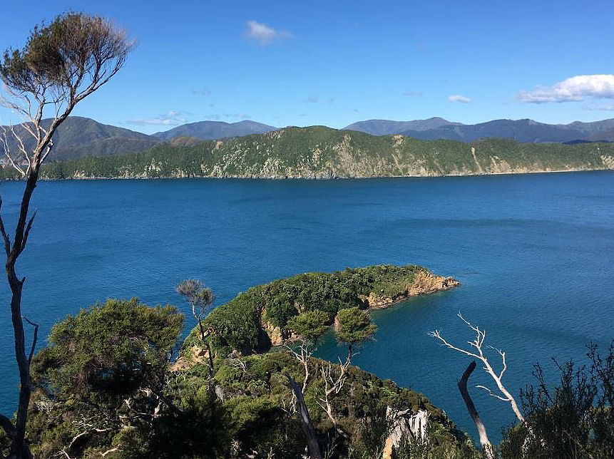
From Motuara in 1770, Cook proclaimed British sovereignty over the Te Waipounamu/the South Island. Lengthy stays by the Europeans allo¬wed for important scientific work in the fields of botany, zoology and astronomy. Over the course of the second and third voyage visits, Meretoto/Ship Cove became one of the most precisely measured places in the world, as latitude and longitude calculations were refined. European plants and animals were introduced, some more successfully than others. Extensive written and artistic records made by the Europeans during and after their Meretoto/Ship Cove visit chronicled activities and relationships in rich detail.
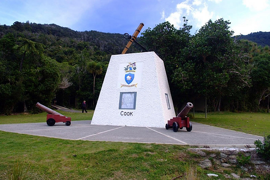
The Cook voyages put Meretoto/Ship Cove on the world map and other early European visitors were drawn there by this association. The site was set aside by the government for its historic significance in 1896, making it Aotearoa/New Zealand’s first historic reserve. Monuments erected in 1913 and 1920 commemorated the Cook connection with little reference to tangata whenua. This was redressed in 2006 with the addition of pouwhenua and interpretation panels that outlined Meretoto/Ship Cove’s bicultural values.
List Entry Information
Status
Listed
List Entry Status
Historic Place Category 1
Access
Able to Visit
List Number
9900
Date Entered
21st February 2019
Date of Effect
13th March 2019
City/District Council
Marlborough District
Region
Marlborough Region
Extent of List Entry
Extent includes the land described as Sec 4 Blk XV Gore SD (NZ Gazette 1976 p 1932), Secs 36, 53 Blk XI Gore SD (NZ Gazette 1986 p 3943), Sec 31, Blk XII Gore SD (NZ Gazette 1986 p 3943), Secs 1,9-10,12-13, Blk XV Gore SD (NZ Gazette 1986 p 3943), Secs 2, 7, Blk XVI Gore SD (NZ Gazette 1986 p 3943), Sec 141 Queen Charlotte Sound District, (NZ Gazette 1986 p 3943), Sec 3, Blk XV Gore SD (NZ Gazette 1926 p 57) Marlborough Land District, and part of the land described as Seabed, Marlborough Land District, and the structures known as the 1913 monument, the 1920 monument and the 2006 pouwhenua. (Refer to map in Appendix 1 of the List entry report for further information).
Legal description
Sec 4 Blk XV Gore SD (NZ Gazette 1976 p 1932), Secs 36, 53 Blk XI Gore SD (NZ Gazette 1986 p 3943), Sec 31, Blk XII Gore SD (NZ Gazette 1986 p 3943), Secs 1,9-10,12-13, Blk XV Gore SD (NZ Gazette 1986 p 3943), Secs 2,7, Blk XVI Gore SD (NZ Gazette 1986 p 3943), Sec 141 Queen Charlotte Sound District, (NZ Gazette 1986 p 3943), Sec 3, Blk XV Gore SD (NZ Gazette 1926 p 57), Seabed. All of this land is in the Marlborough Land District.
Why is this place significant?
Cultural Significance
Cultural Significance or Value The plethora of places in the wider area associated with the ancestor Kupe put Meretoto/Ship Cove within a well-traversed cultural landscape. Meretoto/Ship Cove has strong cultural significance for Māori as the first place of exchange with European people in Te Waipounamu/the South Island since Abel Tasman’s short visit to Mohua/Golden Bay in 1642. Moreover, the exchange at Meretoto/Ship Cove was of much longer duration and moved the relationship well beyond the bloody altercation that formed the sum total of the encounter in 1642. The European written and artistic records possess cultural value for the insights they provide into late 18th century Māori life in this locale and are one pathway that connects contemporary iwi with their tūpuna. Meretoto/Ship Cove is also a place where long-separated Polynesian connections were re-joined through the sustained interactions between Tōtaranui Māori and Tupaia of Ra‘iātea in 1770. Social Significance or Value Meretoto/Ship Cove has social significance as a site for the ongoing public commemoration of the Cook voyages and the meeting of peoples they represent. Community involvement in memorial planning and fundraising and events highlights the social value assigned to the place. This is complemented by its long-held status as a visitor destination based on its dual scenic and historic attractions.
Historic Significance
Historical Significance or Value As a place of early, sustained and repeated contact between Māori and Europeans, Meretoto/Ship Cove is pivotal to Aotearoa/New Zealand’s emergence as a bicultural nation. The relationship forged there was complex, moving back and forth along a continuum, from amicable to tense to violent and thus foreshadowed the challenges that followed organised European settlement in the 19th century. The place is strongly connected with James Cook, a central figure in Aotearoa/New Zealand and international history. Its status as his favourite Aotearoa/New Zealand anchorage, the place he and his fellow voyagers spent the most time at over the three voyages, gives it special historic significance. His declaration of British sovereignty over Te Waipounamu/the South Island from Motuara associates Meretoto/Ship Cove with Aotearoa/New Zealand’s rise as a nation state following the signing of Te Tiriti o Waitangi/The Treaty of Waitangi in 1840. Meretoto/Ship Cove is allied to one of the great European scientific questions of the age and an impetus for the Cook voyages: the whereabouts of Terra Australis Incognita, the fabled great southern continent. The research carried out at the place by Cook and the voyage scientists is of foundational significance to the history of science in Aotearoa/New Zealand, including the field of astronomy. The introduction of European plants and animals to the place presaged a deliberate policy of acclimatisation following organised settlement in the 19th century. The reservation of Meretoto/Ship Cove for its association with Cook in 1896 make it the country’s earliest historic reserve. It is a foundational site in the history of heritage conservation in Aotearoa/New Zealand. Its early recognition is symbolic of burgeoning interest in local history, as is the unveiling of the Cook memorial in 1913 after some years of planning. Recognition of the site’s importance to iwi through the redevelopment of the site in 2006 represents the public flourishing of indigenous historical narratives in the 21st century.
Physical Significance
Aesthetic Significance or Value The bush-clad, sheltered coastal environment of Meretoto/Ship Cove, which provided tangata whenua with fish, birds and other necessary resources, has not changed markedly since the late 18th century. Early reservation of the site and a consequent lack of development preserved the scenic qualities warmly appreciated by James Cook and his fellow voyagers. Thickly clustered trees surrounding the cove that spill down to the water’s edge and the regenerated forest on the now predator-free island of Motuara provide a safe home for the numerous bird species whose music enchanted Joseph Banks in 1770. The positive sensory experience created by the trees, birds, water and topography in concert are reminders of why Meretoto/Ship Cove became Cook’s favourite Aotearoa/New Zealand anchorage. Archaeological Significance or Value Meretoto/Ship Cove is an important archaeological landscape that contains evidence of Māori occupation prior to and during the arrival of Europeans. Further archaeological investigation of the site could yield evidence relating to seasonal occupation by Māori, its contribution to Tōtaranui’s status as a gateway between the Te Ika-a-Māui/the North Island and Te Waipounamu/the South Island, interactions between Māori and Europeans during the Cook voyage period (1770-1777) and any remnants of the European campsites. There is potential for investigation of the sea bed to produce items relating to the European ships, their fabric and contents, as well as objects relating to Māori sea-faring activity.
Why is this place Category 1 / Category 2?
Detail Of Assessed Criteria
(a) The extent to which the place reflects important or representative aspects of New Zealand history Meretoto/Ship Cove has outstanding significance for the extent to which it reflects and represents the origins of Aotearoa/New Zealand’s bicultural identity in all its complexity. The duration of the European visits to this place and the density of interactions between Māori and Europeans compared to those at other Cook anchorages elevate it to the highest level of importance. The wealth of surviving journals, artworks, maps, artefacts and other material records richly document the bicultural interactions that occurred there. Through the declaration of British sovereignty over Te Waipounamu/the South Island, the place functions as the preface to Aotearoa/New Zealand’s emergence as a colony, one of the most significant nineteenth century developments in the country’s history. As Aotearoa/New Zealand’s first historic reserve and one which retains a high public profile for its historic associations, it illuminates shifting narratives around commemorating and interpreting the past, as an exclusive focus on Cook the great navigator has loosened to accommodate other historical players, most significantly Māori. (b) The association of the place with events, persons, or ideas of importance in New Zealand history Meretoto/Ship Cove has outstanding significance for its close association with James Cook. Though his legacy is complex and contested, he is nevertheless acknowledged as one of the most influential figures in Aotearoa/New Zealand and international history, both for his individual qualities and achievements and as a representative of ideas and themes around exploration and discovery, Enlightenment-era scientific endeavour and colonisation. The Ra‘iātean high priest Tupaia’s three-week stay at Meretoto/Ship Cove in 1770 affords the place an outstanding connection to a person who possesses great importance in Aotearoa/New Zealand history through his role as an early cultural mediator, and who is revered within te ao Māori. Meretoto/Ship Cove witnessed some important events in Aotearoa/New Zealand history. It was the base from which Cook became aware that Aotearoa/New Zealand was comprised of two main islands and thus not part of Terra Australis Incognita, the great southern continent the expedition was searching for. Over the course of the second and third voyage visits, it became one of the most astronomically-measured places in the world. The country’s first sheep were released there, albeit unsuccessfully, in an embryonic attempt at acclimatisation. It was the departure point for the first Māori voyage to other South Pacific islands in centuries and possibly ever, a major event in the timeline of a people for whom migration was of foundational importance. The incorporation of the Europeans into Māori lifeways and practices at Meretoto/Ship Cove associate the place with ideas of historical Māori agency. While the Europeans undoubtedly had an impact on their hosts, they were very much visitors to a Māori world, a fact starkly illustrated by the 1773 killings at Wharehunga Bay on Arapāoa, an act of utu carried out for reasons of mana. (c) The potential of the place to provide knowledge of New Zealand history Meretoto/Ship Cove has significance for its capacity to provide knowledge of Aotearoa/New Zealand history through further archaeological investigation. In addition to evidence relating to the centuries of Māori occupation, the place has the potential to shed additional light on early European exploration campsites and Māori-European trading activities through the recovery of items traded and gifted. A number of items acquired by the Europeans at Meretoto/Ship Cove, most notably pounamu, now reside in museums and are potentially available for study, and archaeological investigation may yield evidence of those secured by Māori. Exploration of the seabed could turn up items related to the cleaning and repair of the European ships, rubbish discarded and items lost from those ships, as well as evidence that illuminates Māori use of the sea. The wealth of European documentary material has the potential to produce new insights as research questions and topics evolve. (d) The importance of the place to tangata whenua Meretoto/Ship Cove has outstanding significance for Te Tau Ihu iwi as a site of early sustained encounter with Europeans. It has special meaning for Ngāti Apa, Ngāti Kuia and Rangitāne, all of whom held mana whenua over the wider area during the Cook visits, and it is a site of significance for later arrivals Ngāti Toa and present-day kaitiaki Te Ātiawa. It is also significant as a meeting place between tangata whenua and Tupaia of Ra‘iātea, who has been remembered by Ngāti Kuia in a lament. (e) The community association with, or public esteem for the place Meretoto/Ship Cove has significance for its general public esteem. It has attracted visitors due to its Cook associations and remarkable scenic qualities since the early nineteenth century and its status as a Department of Conservation ICON site in the twenty-first century demonstrates an enduring high level of public interest in the site. (f) The potential of the place for public education Meretoto/Ship Cove has outstanding significance for its public education potential. The intactness of the site allows visitors to understand and experience at first hand the qualities that made it Cook’s favourite anchorage, a quality which elevates its historic significance. The ability to sail safely throughout the calm waters of the wider Sound to and from Raukawa Moana/Cook Strait shows why Tōtaranui was the gateway between Te Ika-a-Māui/the North Island and Te Waipounamu/the South island in earlier times. The place is on a major Department of Conservation track and accessible by water, allowing year-round access. (h) The symbolic or commemorative value of the place Memorials at Meretoto/Ship Cove and Motuara commemorate Cook, a figure of outstanding national and international historic significance. The reservation of Meretoto/Ship Cove for its historic associations in 1896 and unveiling of the first memorial in 1913 demonstrates a particularly long-standing appreciation of the place’s commemorative qualities, as does ongoing public events there on key dates. The 2006 pouwhenua and related features highlight the place’s strong commemorative values for Māori. The place as a whole symbolises the origins of bicultural Aotearoa/New Zealand, one of the country’s defining features. (i) The importance of identifying historic places known to date from an early period of New Zealand settlement Meretoto/Ship Cove has outstanding significance as the site of the most sustained contact between Māori and Europeans over the Cook voyages period (1769-1777), a critically important time in Aotearoa/New Zealand history that predates organised European settlement by over 60 years. Aside from the inevitable disappearance of above-ground structures associated with pā and kāinga and the addition of monuments and visitor amenities, the place closely resembles its late 18th century self. (j) The importance of identifying rare types of historic places Meretoto/Ship Cove is rare because it is one of only two places the Cook expeditions visited in Te Waipounamu/the South Island. It has overall rarity value because the expedition parties were based there for just over half the time spent in Aotearoa/New Zealand between 1769 and 1777. Meaningful interactions occurred at other sites in Te Ika-a-Māui/the North Island (mainly during the first voyage) and Tamatea/Dusky Sound in Te Waipounamu/the South Island (second voyage), but the length of time spent at Meretoto/Ship Cove over six visits meant the two peoples came to know something about one another in a way not possible at other contact sites. It was the only Aotearoa/New Zealand site visited during the third and final voyage. (k) The extent to which the place forms part of a wider historical and cultural area Due to its location in Tōtaranui/Queen Charlotte Sound, Meretoto/Ship Cove is part of a wider landscape of historical, cultural and archaeological significance. It sits among many places named by Kupe and preserved by generations of occupants, and is therefore associated with the imprint of an important ancestor. The recorded archaeological sites in the Sound’s numerous bays and islands signify extensive Māori occupation of the area, which was a gateway between Te Ika-a-Māui/the North Island and Te Waipounamu/the South island. New place names given by Cook, most obviously ‘Ship Cove’, added another layer to the cultural map. Places in the wider area were visited from the Meretoto/Ship Cove base, such as Arapāoa (a Kupe site), the location of two key events: Cook’s ‘discovery’ of Raukawa Moana/Cook Strait and the 1773 killing of 10 Adventure crewmen. Meretoto/Ship Cove can also be seen as an eminent feature of a cultural landscape comprised of Cook visit sites that extends over both islands. It is one of many public conservation areas in the Marlborough Sounds. Summary of Significance or Values Meretoto/Ship Cove has outstanding significance as a key foundational site in the story of bicultural Aotearoa/New Zealand. Its selection by James Cook as the expedition base meant that extensive and sustained interactions between Māori and Europeans resulted in a degree of familiarity not possible at other anchorage sites. It is deeply significant for tangata whenua as a site of first encounter with Europeans and Tupaia of Ra‘iātea. It has special significance as a very early bicultural contact-era place and has rarity value as only one of two Te Waipounamu/South Island sites visited by Cook, and the only Aotearoa/New Zealand place visited on the third voyage. As Cook’s self-described ‘old station’, it is closely associated with this critical figure in Aotearoa/New Zealand and international history. As the site from which Cook declared British sovereignty over Te Waipounamu/the South Island, it has outstanding significance for its association with Aotearoa/New Zealand’s rise as a nation state and colony on the signing of Te Tiriti o Waitangi/The Treaty of Waitangi in 1840. As the first place in Aotearoa/New Zealand reserved by the government for its historic associations, Meretoto/Ship Cove is a vitally important site in the history of heritage conservation. Its outstanding commemorative value is demonstrated by the installation, over nearly 100 years, of two single and one group of monuments that together symbolise the place’s bicultural significance. As a place that resembles its late 18th century self, Meretoto/Ship Cove retains many of the attributes appreciated by Māori and Europeans alike. To stand on its shores is to understand why it became Cook’s favourite anchorage.
Construction Professional
Name
Reg Thompsett
Type
Carver
Biography
No biography is currently available for this construction professional
Construction Details
Start Year
1913
Type
Other
Description
Unveiling of the mainland monument
Start Year
1920
Type
Other
Description
Unveiling of the Motuara monument
Start Year
2006
Type
Other
Description
Unveiling of the pouwhenua, bridge and visitor amenities
Construction Materials
1913 monument Concrete, pebble-dash, marble, iron, timber 1920 monument Concrete, pebble-dash 2006 pouwhenua Tōtara
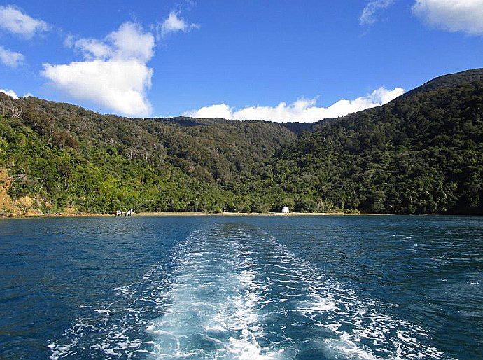
Meretoto/Ship Cove is a bay on the west side of Tōtaranui/Queen Charlotte Sound near its opening at Raukawa Moana/Cook Strait. Sheltered by the island of Motuara, it resides within Te Tau Ihu o Te Waka-a-Māui, the top of the Te Waipounamu/the South Island. In tribal narratives, Te Tau Ihu o Te Waka-a-Māui is the prow of the demigod Māui’s canoe, where he stood to fish up Te Ika-a-Māui/the North Island. The area’s place names are associated with the ancestor Kupe and his battles with the octopus Whekenui whom he finally killed at Arapāoa Island, so-named for the downward blow (‘arapāoa’) of his patu. Tangata whenua Migrants who traced their descent to the ancestral waka Kurahaupō landed in Tōtaranui in the centuries after Aotearoa was first settled (1250–1300 AD). It was the natural gateway between Te Waipounamu and Te Ika-a-Māui because the best route across the strait was between Tōtaranui and the southwest corner of the North Island, a relatively calm sea path guided by favourable north-westerly winds. Traders visited Tōtaranui on their way to and from the argillite quarries of Whakatū/Nelson and Rangitoto and the pounamu deposits further south. This path was also well-trodden by taua (war parties). Tōtaranui’s flow of human traffic militated against stable occupancy by one tribal group. Beginning in the fifteenth century, major, successive tribal migrations from north to south occurred. In the late 18th century, Tōtaranui was controlled by Rangitāne, Ngāti Apa and Ngāti Kuia. Meretoto itself was one of the first places settled by Rangitāne when they migrated from Wairarapa the previous century. Small whānau groups occupied Tōtaranui’s bays on a seasonal basis and were sustained by fishing, hunting and gathering rather than horticulture, which required more settled conditions to flourish. There was no one dominant tribe in Te Tau Ihu and ‘fighting was never far away.’ New arrivals On the morning of 15 January 1770, a large ship entered Tōtaranui and dropped anchor at Meretoto in the early afternoon. Captain James Cook (1728–1779) and the Endeavour had first made landfall at Tūranganui-a-Kiwa on the east coast of Te Ika-a-Māui in October the previous year, having sailed to Aotearoa from Tahiti. On board was the Ra‘iātean high priest Tupaia. He was able to converse with Māori because the languages were sufficiently similar and proved a crucial cultural go-between. This was the first European visit to Te Waipounamu since the brief, violent encounter between Dutch explorer Abel Tasman’s expedition and Ngāti Tūmatakōkiri at Mohua/Golden Bay in 1642 that left four Dutchmen and possibly one Māori man dead. The Endeavour’s entry was observed by lookouts on Te Taonui-a-Kupe/Cape Jackson. The pā off the southern end of Motuara was crowded with people who had retreated there from nearby kāinga (villages) for safety. The Europeans arrived at a time of inter-tribal conflict and though word of them had already spread from the north, the people were sheltering from local enemies rather than the newcomers. Science, exploration and empire The purpose of Cook’s first voyage to the South Pacific (1768-71), jointly sponsored by the Royal Society and the Admiralty Department and driven by Enlightenment thought, was twofold: to observe the transit of Venus and to find Terra Australis Incognita, the fabled great southern continent first postulated by Classical Greek scholars. The hunt for Terra Australis continued on the second voyage (1772-75). On the third voyage (1776-80) they unsuccessfully searched for a north-west passage between the Atlantic and the Pacific. Driven by Great Britain’s imperialist motivations, strategic concerns were also at play as Cook assessed the natural resources and settlement potential of the new lands ‘discovered’. Cook’s favourite anchorage Cook anchored at Meretoto to careen the ship and obtain fresh provisions. It became apparent that the bay, which he dubbed ‘Ship Cove’, was an ideal base from which to rest the crew at shore camps, undertake scientific work and launch further explorations. It was sheltered by steep hills on three sides and Motuara offshore and the gently sloping sandy beach offered the perfect gradient for turning the ship on its side for repairs. There was plentiful fresh water and the seawaters were crowded with a variety of fish. The thick bush (‘one intire [sic] forest’) was a source of wood and birds good for eating, while plants that warded off the disease scurvy were abundant. The bay itself was not occupied in 1770 but people from nearby kāinga were keen to trade and the visitors were supplied with fresh and dried fish in addition to what their nets yielded. To these material benefits was added the sheer beauty of the cove, accentuated by what botanist Joseph Banks described as the birds’ ‘most melodious wild musick’ [sic]. Meretoto/Ship Cove was the only Aotearoa/New Zealand place visited each time over Cook’s three Pacific voyages, one of only two South Island sites visited and sole stop of the last voyage. The ships spent longer there than any other anchorage: 170 out of a total of 328 days in the country. On the last visit to Aotearoa/New Zealand in 1777 Cook called it ‘our old station’. First voyage: one visit (1770) On the Endeavour’s arrival, four waka launched from Motuara circled the ship. The occupants threw stones and offered verbal challenges before the rangatira Topaa indicated he wished to board. Tension was dispelled when Tupaia welcomed him with a hongi, which prompted the toa (warriors) on the waka to laugh loudly and join their leader. This incident foreshadowed the great esteem the people of Tōtaranui came to feel for Tupaia, a feeling replicated among iwi at other Aotearoa/New Zealand anchorages. It also highlighted his indispensability to the Europeans ̶ he was, as Cook wrote, ‘of infinite service’. For Tōtaranui Māori, Tupaia was a living embodiment of their Polynesian origins. They spoke with him at length throughout his three-week stay, exchanging knowledge about shared roots and debating cultural practices such as kaitangata (cannibalism). When the Europeans returned in 1773, the first person asked for was Tupaia and there was widespread mourning when news of his death in late 1770 was shared, even among those who had not met him, and Ngāti Kuia composed a lament. While the sailors were busy repairing the ship and Tupaia spoke with tangata whenua, Cook, his officers, the artists, and the scientists on board, led by Joseph Banks, explored the sounds. From a hill on Arapāoa Cook saw Raukawa Moana/Cook Strait, the first telling sign that Aotearoa/New Zealand was not part of a great southern continent and a discovery which provoked ‘high spirits’ in the normally restrained captain. Topaa and others confirmed the existence of the North and South Islands, which Cook later circumnavigated, providing final first-hand proof. On 31 January Cook raised the Union flag on Motuara and proclaimed British sovereignty over the Te Waipounamu/the South Island, having made the same declaration over what he now knew was Te Ika-a-Māui/the North Island at Te Whanganui-a-Hei/Mercury Bay the previous year. To Topaa, he merely said the pole was to show other ships that ‘we had been here before’. The nascent relationship between Māori and Europeans was amicable but tested. Cook wounded a man who tried to snatch goods during trading, while another was killed by an officer who feared attack after interfering with a tapu site. It is likely that venereal disease was introduced into the local population. In the days before the Endeavour left on 6 February, Tōtaranui Māori had tired of their resource-hungry visitors and refused to sell any more fish. The second voyage: four visits (1773-1774) During the first voyage, Cook conclusively demonstrated that Aotearoa/New Zealand was not part of Terra Australis but the continent’s existence was neither proved nor disproved. Settling this question was the primary purpose of the second voyage undertaken by two ships, Cook’s Resolution, and the Adventure, captained by Tobias Furneaux. By early 1774 it was clear the continent was not in the South Pacific. The ships spent 133 days over four visits at Meretoto/Ship Cove between 1773 and 1774: • Visit one: Adventure 6 April–7 June 1773 and Resolution 18 May–7 June 1773 • Visit two: Resolution 3–25 November 1773 • Visit three: Adventure 30 November–22 December 1773 • Visit four: Resolution 18 October–10 November 1774. Relationships became tense during these visits. Repeated theft of European goods was likely muru (ritual confiscation), given the amount of natural resources the visitors were consuming without permission, and the ships’ rowboats were chased by waka on a number of occasions. On 17 December 1773, 10 of the Adventure’s crew rowed to Wharehunga Bay on Arapāoa to cut grass for the ship’s livestock and never returned. The following day a search party discovered their fellow crewmen had been killed, dismembered, cooked and partially eaten. The Adventure left for good four days later. When the Resolution returned almost a year after, Cook dismissed vague rumours about the killings. The third voyage: one visit (1777) The Resolution and the Discovery (captained by Charles Clerke) arrived at Meretoto/Ship Cove on 12 February 1777. They stayed two weeks before heading for North America to search for the north-west passage. Cook learned more about the 1773 killings. The rangatira Matahoua told him seaman Jack Rowe opened fire on a group of Māori, killing two, after bread was stolen from the rowboat. Another informant said the Ngāti Kuia rangatira Kahura, who appeared to be the principal protagonist on the Māori side, was hit on the head after taking items from the boat, a serious breach of tapu requiring utu (retaliation) for reasons of mana. Regardless of the exact circumstances, the Europeans were outnumbered and all were killed in the ensuing violence. For his time, Cook was relatively respectful in his attitude towards indigenous peoples and tried to avoid violence. During this final visit he did not retaliate, instead inviting Kahura into his cabin and having his portrait sketched. This approach pleased few. Cook’s esteem fell among his crew and he suffered a loss of mana with Māori as they expected him to avenge the killings. When the ships left on 26 February, the youths Te Weherua and Koa, whose whānau had engaged in much trading with the Europeans, were on board the Resolution. On reaching the Cook Islands, they likely became the first Māori to voyage from Aotearoa/New Zealand to other Pacific islands in many hundreds of years and conceivably ever, if the first migrants did not make return journeys. Science The intellectual aims of the voyages attracted an array of scientists and observers whose activities at Meretoto/Ship Cove constitute some of the earliest European scientific endeavours in Aotearoa/New Zealand. The long stays allowed for systematic and extensive work. During the first visit, botanists Joseph Banks and Daniel Solander ‘nearly exhausted all the Plants’ and had great success collecting mosses. Naturalists Johann and Georg Forster and Anders Sparrman collected and described numerous birds and fish on the second voyage visits. Significant activity occurred in the field of astronomy. Cook and Charles Green made astronomical observations from the Endeavour to calculate latitude and longitude for navigation and mapping purposes, but this work was stepped up on subsequent voyages with the aid of chronometers, which kept accurate time at sea. Astronomer William Bayley of the Adventure set up an observatory in a whare (house) at the now-abandoned pā off Motuara in April 1773, while William Wales erected a tent observatory at the bay when the Discovery arrived the following month. Over the five visits of the second and third voyages, latitude and longitude calculations were refined to the extent that ‘the position of Ship Cove was better established than almost any other place on the surface of the Earth’ including Greenwich, home of the Royal Observatory. In 1770 Cook made an important contribution to geology with the country’s first measurement of magnetic declination (difference in angle between geographic and magnetic north) made at Meretoto/Ship Cove. Trading Mutually-advantageous trading facilitated interaction between Māori and Europeans at Meretoto/Ship Cove. In 1770 Tōtaranui Māori were impoverished by constant conflict and the only commodity they were willing and able to part with was fish, in return for nails and cloth. Though most of the Europeans viewed cannibalism with horror, human bones were sought-after curios. On this first visit Joseph Banks became the first European to acquire a mokomōkai (preserved tattooed head). Europeans were incorporated into Tōtaranui’s existing function as a trading centre. The opportunity to acquire valuable European goods attracted Māori traders from Te Ika-a-Māui/the North Island and Ngāi Tahu from other parts of Te Waipounamu/the South Island during the second and third voyage visits, and they set up camp there. These traders were more affluent than Tōtaranui Māori and had a wider range of goods to trade, including pounamu, which was so sought-after ‘that there was hardly a thing [Europeans] would not give for a piece of it.’ Production of pounamu artefacts for the European market increased dramatically between 1773 and 1777, and manufacturing was supplemented by items acquired through warfare. Almost all the Cook-era pounamu artefacts that found their way into museum collections were acquired at Meretoto/Ship Cove and environs. Nails remained the most desirable European commodity, joined by Tahitian tapa cloth (second voyage) and hatchets (third voyage). The provision of sexual services to the Europeans became more formalised from 1773, with Māori men controlling a trade previously provided informally by women. Animals and plants European animals and plants were first introduced during the second voyage visits. Gardens were planted on Motuara and other islands in the Sound and hens, pigs, sheep and goats were released into the bush. The sheep and goats did not take to their new home. To Cook’s dismay, the first pair of sheep ever released in Aotearoa/New Zealand were found dead three days later after eating poisonous plants, his ‘hopes of stocking this country with a breed of sheep…blasted in a moment’. The male goat ran into the sea twice before disappearing, having likely drowned, leaving the female with no mate. The hen and pig releases were successful and both established breeding populations. Many of the gardens had disappeared by 1777 but plants like potatoes were incorporated into local horticulture and spread throughout the Te Waipounamu/the South Island from Tōtaranui. Artistic and written records Artists were present on all three voyages and their depictions of Meretoto/Ship Cove, Tōtaranui and the area’s people are among the earliest pictorial records of Aotearoa/New Zealand. Cook and a number of officers kept journals recording daily activities and interactions with Māori. These, along with maps, charts, ship logs and te reo vocabularies, are detailed records of sustained cross-cultural interactions. The Endeavour works depict peoples meeting for the first time, and in the case of Tupaia, reuniting after centuries of separation. Records from subsequent voyages chart Māori communities incorporating the visitors into their lives. While European artworks and diaries are inevitably inflected with their creators’ biases and imperfect understanding, they provide a record of life in Tōtaranui prior the so-called ‘musket wars’ period of the late 1820s and early 1830s which mark the arrival of Te Ātiawa and Ngāti Toa. Later visitors These records put Meretoto/Ship Cove on the world map and alerted Europeans at home to its existence, though subsequent visits did not begin until around 1810, when sealers and whalers anchored there. Primed by the journals, later European visitors saw themselves as following in Cook’s footsteps. The Russian polar expedition led by Fabian von Bellingshausen rested in and around Meretoto/Ship Cove for twelve days in 1820 and the officers regularly referred to the Cook records and made use of the vocabularies. When the New Zealand Company’s Tory anchored there for two weeks in 1839, company agent William Wakefield noted they occupied ‘nearly the same position as Captain Cook’. Tōtaranui Māori were aware of European interest in the Cook visits. When the survey vessel Acheron stopped there in 1850, the party was asked if they wanted to see a tree Cook tied ships to. Commemoration In line with growing interest in Aotearoa/New Zealand history and its European ‘founders’ sparked by 50th jubilee events, over 2,000 acres of thick forest around Meretoto/Ship Cove was reserved ‘in memory of its occupation by Captain Cook’ in 1896. Meretoto/Ship Cove was the first site reserved by the government for its historic significance and predated the Scenery Preservation Act 1903, the first law specifically passed to protect places of scenic and historic value. The scenic and historic attractions made it a visitor destination from the late nineteenth century. In 1906, about 550 people attended the Blenheim Rifle Company’s summer picnic at the bay and a Cook memorial was the topic of conversation over lunch. After seven years planning and fundraising by a Marlborough committee, a large concrete monument was unveiled by the Governor Lord Liverpool before a crowd of 2,000 on 11 February 1913. It was the country’s second Cook memorial, having been preceded by the obelisk erected at the 1769 landing site at Gisborne in 1906. Another Cook monument was installed on Motuara in 1920. In 1970, the bicentenary of the Endeavour’s arrival at Meretoto/Ship Cove was commemorated by an elaborate re-enactment repeated two months later for a royal visit by Queen Elizabeth II. In 1996 an Endeavour replica re-enacted the arrival alongside the Te Awatea Hou waka representing the iwi of Te Tau Ihu. Ten years later, the Department of Conservation (DOC) in partnership with iwi redeveloped the site to better reflect its bicultural significance and acknowledge mana whenua. This included the installation of a free-standing pouwhenua, a bridge with two pouwhenua, one representing the Kurahaupō iwi (Rāngitane, Ngāti Apa and Ngāti Kuia) and the other representing Te Ātiawa; a visitor shelter, seating, tables and interpretation panels. Meretoto/Ship Cove became one of the first DOC Icon cultural heritage sites in 2006/07. In 2020, the 250th anniversary of the encounters will be commemorated through events organised the community-led Tōtaranui 250 Trust.
Meretoto/Ship Cove is a bay on the west side of Tōtaranui/Queen Charlotte Sound near its opening at Raukawa Moana/Cook Strait. Sheltered by the island of Motuara, it resides within Te Tau Ihu o Te Waka-a-Māui, the top of the Te Waipounamu/the South Island. In tribal narratives, Te Tau Ihu o Te Waka-a-Māui is the prow of the demigod Māui’s canoe, where he stood to fish up Te Ika-a-Māui/the North Island. The area’s place names are associated with the ancestor Kupe and his battles with the octopus Whekenui whom he finally killed at Arapāoa Island, so-named for the downward blow (‘arapāoa’) of his patu. Tangata whenua Migrants who traced their descent to the ancestral waka Kurahaupō landed in Tōtaranui in the centuries after Aotearoa was first settled (1250–1300 AD). It was the natural gateway between Te Waipounamu and Te Ika-a-Māui because the best route across the strait was between Tōtaranui and the southwest corner of the North Island, a relatively calm sea path guided by favourable north-westerly winds. Traders visited Tōtaranui on their way to and from the argillite quarries of Whakatū/Nelson and Rangitoto and the pounamu deposits further south. This path was also well-trodden by taua (war parties). Tōtaranui’s flow of human traffic militated against stable occupancy by one tribal group. Beginning in the fifteenth century, major, successive tribal migrations from north to south occurred. In the late 18th century, Tōtaranui was controlled by Rangitāne, Ngāti Apa and Ngāti Kuia. Meretoto itself was one of the first places settled by Rangitāne when they migrated from Wairarapa the previous century. Small whānau groups occupied Tōtaranui’s bays on a seasonal basis and were sustained by fishing, hunting and gathering rather than horticulture, which required more settled conditions to flourish. There was no one dominant tribe in Te Tau Ihu and ‘fighting was never far away.’ New arrivals On the morning of 15 January 1770, a large ship entered Tōtaranui and dropped anchor at Meretoto in the early afternoon. Captain James Cook (1728–1779) and the Endeavour had first made landfall at Tūranganui-a-Kiwa on the east coast of Te Ika-a-Māui in October the previous year, having sailed to Aotearoa from Tahiti. On board was the Ra‘iātean high priest Tupaia. He was able to converse with Māori because the languages were sufficiently similar and proved a crucial cultural go-between. This was the first European visit to Te Waipounamu since the brief, violent encounter between Dutch explorer Abel Tasman’s expedition and Ngāti Tūmatakōkiri at Mohua/Golden Bay in 1642 that left four Dutchmen and possibly one Māori man dead. The Endeavour’s entry was observed by lookouts on Te Taonui-a-Kupe/Cape Jackson. The pā off the southern end of Motuara was crowded with people who had retreated there from nearby kāinga (villages) for safety. The Europeans arrived at a time of inter-tribal conflict and though word of them had already spread from the north, the people were sheltering from local enemies rather than the newcomers. Science, exploration and empire The purpose of Cook’s first voyage to the South Pacific (1768-71), jointly sponsored by the Royal Society and the Admiralty Department and driven by Enlightenment thought, was twofold: to observe the transit of Venus and to find Terra Australis Incognita, the fabled great southern continent first postulated by Classical Greek scholars. The hunt for Terra Australis continued on the second voyage (1772-75). On the third voyage (1776-80) they unsuccessfully searched for a north-west passage between the Atlantic and the Pacific. Driven by Great Britain’s imperialist motivations, strategic concerns were also at play as Cook assessed the natural resources and settlement potential of the new lands ‘discovered’. Cook’s favourite anchorage Cook anchored at Meretoto to careen the ship and obtain fresh provisions. It became apparent that the bay, which he dubbed ‘Ship Cove’, was an ideal base from which to rest the crew at shore camps, undertake scientific work and launch further explorations. It was sheltered by steep hills on three sides and Motuara offshore and the gently sloping sandy beach offered the perfect gradient for turning the ship on its side for repairs. There was plentiful fresh water and the seawaters were crowded with a variety of fish. The thick bush (‘one intire [sic] forest’) was a source of wood and birds good for eating, while plants that warded off the disease scurvy were abundant. The bay itself was not occupied in 1770 but people from nearby kāinga were keen to trade and the visitors were supplied with fresh and dried fish in addition to what their nets yielded. To these material benefits was added the sheer beauty of the cove, accentuated by what botanist Joseph Banks described as the birds’ ‘most melodious wild musick’ [sic]. Meretoto/Ship Cove was the only Aotearoa/New Zealand place visited each time over Cook’s three Pacific voyages, one of only two South Island sites visited and sole stop of the last voyage. The ships spent longer there than any other anchorage: 170 out of a total of 328 days in the country. On the last visit to Aotearoa/New Zealand in 1777 Cook called it ‘our old station’. First voyage: one visit (1770) On the Endeavour’s arrival, four waka launched from Motuara circled the ship. The occupants threw stones and offered verbal challenges before the rangatira Topaa indicated he wished to board. Tension was dispelled when Tupaia welcomed him with a hongi, which prompted the toa (warriors) on the waka to laugh loudly and join their leader. This incident foreshadowed the great esteem the people of Tōtaranui came to feel for Tupaia, a feeling replicated among iwi at other Aotearoa/New Zealand anchorages. It also highlighted his indispensability to the Europeans ̶ he was, as Cook wrote, ‘of infinite service’. For Tōtaranui Māori, Tupaia was a living embodiment of their Polynesian origins. They spoke with him at length throughout his three-week stay, exchanging knowledge about shared roots and debating cultural practices such as kaitangata (cannibalism). When the Europeans returned in 1773, the first person asked for was Tupaia and there was widespread mourning when news of his death in late 1770 was shared, even among those who had not met him, and Ngāti Kuia composed a lament. While the sailors were busy repairing the ship and Tupaia spoke with tangata whenua, Cook, his officers, the artists, and the scientists on board, led by Joseph Banks, explored the sounds. From a hill on Arapāoa Cook saw Raukawa Moana/Cook Strait, the first telling sign that Aotearoa/New Zealand was not part of a great southern continent and a discovery which provoked ‘high spirits’ in the normally restrained captain. Topaa and others confirmed the existence of the North and South Islands, which Cook later circumnavigated, providing final first-hand proof. On 31 January Cook raised the Union flag on Motuara and proclaimed British sovereignty over the Te Waipounamu/the South Island, having made the same declaration over what he now knew was Te Ika-a-Māui/the North Island at Te Whanganui-a-Hei/Mercury Bay the previous year. To Topaa, he merely said the pole was to show other ships that ‘we had been here before’. The nascent relationship between Māori and Europeans was amicable but tested. Cook wounded a man who tried to snatch goods during trading, while another was killed by an officer who feared attack after interfering with a tapu site. It is likely that venereal disease was introduced into the local population. In the days before the Endeavour left on 6 February, Tōtaranui Māori had tired of their resource-hungry visitors and refused to sell any more fish. The second voyage: four visits (1773-1774) During the first voyage, Cook conclusively demonstrated that Aotearoa/New Zealand was not part of Terra Australis but the continent’s existence was neither proved nor disproved. Settling this question was the primary purpose of the second voyage undertaken by two ships, Cook’s Resolution, and the Adventure, captained by Tobias Furneaux. By early 1774 it was clear the continent was not in the South Pacific. The ships spent 133 days over four visits at Meretoto/Ship Cove between 1773 and 1774: • Visit one: Adventure 6 April–7 June 1773 and Resolution 18 May–7 June 1773 • Visit two: Resolution 3–25 November 1773 • Visit three: Adventure 30 November–22 December 1773 • Visit four: Resolution 18 October–10 November 1774. Relationships became tense during these visits. Repeated theft of European goods was likely muru (ritual confiscation), given the amount of natural resources the visitors were consuming without permission, and the ships’ rowboats were chased by waka on a number of occasions. On 17 December 1773, 10 of the Adventure’s crew rowed to Wharehunga Bay on Arapāoa to cut grass for the ship’s livestock and never returned. The following day a search party discovered their fellow crewmen had been killed, dismembered, cooked and partially eaten. The Adventure left for good four days later. When the Resolution returned almost a year after, Cook dismissed vague rumours about the killings. The third voyage: one visit (1777) The Resolution and the Discovery (captained by Charles Clerke) arrived at Meretoto/Ship Cove on 12 February 1777. They stayed two weeks before heading for North America to search for the north-west passage. Cook learned more about the 1773 killings. The rangatira Matahoua told him seaman Jack Rowe opened fire on a group of Māori, killing two, after bread was stolen from the rowboat. Another informant said the Ngāti Kuia rangatira Kahura, who appeared to be the principal protagonist on the Māori side, was hit on the head after taking items from the boat, a serious breach of tapu requiring utu (retaliation) for reasons of mana. Regardless of the exact circumstances, the Europeans were outnumbered and all were killed in the ensuing violence. For his time, Cook was relatively respectful in his attitude towards indigenous peoples and tried to avoid violence. During this final visit he did not retaliate, instead inviting Kahura into his cabin and having his portrait sketched. This approach pleased few. Cook’s esteem fell among his crew and he suffered a loss of mana with Māori as they expected him to avenge the killings. When the ships left on 26 February, the youths Te Weherua and Koa, whose whānau had engaged in much trading with the Europeans, were on board the Resolution. On reaching the Cook Islands, they likely became the first Māori to voyage from Aotearoa/New Zealand to other Pacific islands in many hundreds of years and conceivably ever, if the first migrants did not make return journeys. Science The intellectual aims of the voyages attracted an array of scientists and observers whose activities at Meretoto/Ship Cove constitute some of the earliest European scientific endeavours in Aotearoa/New Zealand. The long stays allowed for systematic and extensive work. During the first visit, botanists Joseph Banks and Daniel Solander ‘nearly exhausted all the Plants’ and had great success collecting mosses. Naturalists Johann and Georg Forster and Anders Sparrman collected and described numerous birds and fish on the second voyage visits. Significant activity occurred in the field of astronomy. Cook and Charles Green made astronomical observations from the Endeavour to calculate latitude and longitude for navigation and mapping purposes, but this work was stepped up on subsequent voyages with the aid of chronometers, which kept accurate time at sea. Astronomer William Bayley of the Adventure set up an observatory in a whare (house) at the now-abandoned pā off Motuara in April 1773, while William Wales erected a tent observatory at the bay when the Discovery arrived the following month. Over the five visits of the second and third voyages, latitude and longitude calculations were refined to the extent that ‘the position of Ship Cove was better established than almost any other place on the surface of the Earth’ including Greenwich, home of the Royal Observatory. In 1770 Cook made an important contribution to geology with the country’s first measurement of magnetic declination (difference in angle between geographic and magnetic north) made at Meretoto/Ship Cove. Trading Mutually-advantageous trading facilitated interaction between Māori and Europeans at Meretoto/Ship Cove. In 1770 Tōtaranui Māori were impoverished by constant conflict and the only commodity they were willing and able to part with was fish, in return for nails and cloth. Though most of the Europeans viewed cannibalism with horror, human bones were sought-after curios. On this first visit Joseph Banks became the first European to acquire a mokomōkai (preserved tattooed head). Europeans were incorporated into Tōtaranui’s existing function as a trading centre. The opportunity to acquire valuable European goods attracted Māori traders from Te Ika-a-Māui/the North Island and Ngāi Tahu from other parts of Te Waipounamu/the South Island during the second and third voyage visits, and they set up camp there. These traders were more affluent than Tōtaranui Māori and had a wider range of goods to trade, including pounamu, which was so sought-after ‘that there was hardly a thing [Europeans] would not give for a piece of it.’ Production of pounamu artefacts for the European market increased dramatically between 1773 and 1777, and manufacturing was supplemented by items acquired through warfare. Almost all the Cook-era pounamu artefacts that found their way into museum collections were acquired at Meretoto/Ship Cove and environs. Nails remained the most desirable European commodity, joined by Tahitian tapa cloth (second voyage) and hatchets (third voyage). The provision of sexual services to the Europeans became more formalised from 1773, with Māori men controlling a trade previously provided informally by women. Animals and plants European animals and plants were first introduced during the second voyage visits. Gardens were planted on Motuara and other islands in the Sound and hens, pigs, sheep and goats were released into the bush. The sheep and goats did not take to their new home. To Cook’s dismay, the first pair of sheep ever released in Aotearoa/New Zealand were found dead three days later after eating poisonous plants, his ‘hopes of stocking this country with a breed of sheep…blasted in a moment’. The male goat ran into the sea twice before disappearing, having likely drowned, leaving the female with no mate. The hen and pig releases were successful and both established breeding populations. Many of the gardens had disappeared by 1777 but plants like potatoes were incorporated into local horticulture and spread throughout the Te Waipounamu/the South Island from Tōtaranui. Artistic and written records Artists were present on all three voyages and their depictions of Meretoto/Ship Cove, Tōtaranui and the area’s people are among the earliest pictorial records of Aotearoa/New Zealand. Cook and a number of officers kept journals recording daily activities and interactions with Māori. These, along with maps, charts, ship logs and te reo vocabularies, are detailed records of sustained cross-cultural interactions. The Endeavour works depict peoples meeting for the first time, and in the case of Tupaia, reuniting after centuries of separation. Records from subsequent voyages chart Māori communities incorporating the visitors into their lives. While European artworks and diaries are inevitably inflected with their creators’ biases and imperfect understanding, they provide a record of life in Tōtaranui prior the so-called ‘musket wars’ period of the late 1820s and early 1830s which mark the arrival of Te Ātiawa and Ngāti Toa. Later visitors These records put Meretoto/Ship Cove on the world map and alerted Europeans at home to its existence, though subsequent visits did not begin until around 1810, when sealers and whalers anchored there. Primed by the journals, later European visitors saw themselves as following in Cook’s footsteps. The Russian polar expedition led by Fabian von Bellingshausen rested in and around Meretoto/Ship Cove for twelve days in 1820 and the officers regularly referred to the Cook records and made use of the vocabularies. When the New Zealand Company’s Tory anchored there for two weeks in 1839, company agent William Wakefield noted they occupied ‘nearly the same position as Captain Cook’. Tōtaranui Māori were aware of European interest in the Cook visits. When the survey vessel Acheron stopped there in 1850, the party was asked if they wanted to see a tree Cook tied ships to. Commemoration In line with growing interest in Aotearoa/New Zealand history and its European ‘founders’ sparked by 50th jubilee events, over 2,000 acres of thick forest around Meretoto/Ship Cove was reserved ‘in memory of its occupation by Captain Cook’ in 1896. Meretoto/Ship Cove was the first site reserved by the government for its historic significance and predated the Scenery Preservation Act 1903, the first law specifically passed to protect places of scenic and historic value. The scenic and historic attractions made it a visitor destination from the late nineteenth century. In 1906, about 550 people attended the Blenheim Rifle Company’s summer picnic at the bay and a Cook memorial was the topic of conversation over lunch. After seven years planning and fundraising by a Marlborough committee, a large concrete monument was unveiled by the Governor Lord Liverpool before a crowd of 2,000 on 11 February 1913. It was the country’s second Cook memorial, having been preceded by the obelisk erected at the 1769 landing site at Gisborne in 1906. Another Cook monument was installed on Motuara in 1920. In 1970, the bicentenary of the Endeavour’s arrival at Meretoto/Ship Cove was commemorated by an elaborate re-enactment repeated two months later for a royal visit by Queen Elizabeth II. In 1996 an Endeavour replica re-enacted the arrival alongside the Te Awatea Hou waka representing the iwi of Te Tau Ihu. Ten years later, the Department of Conservation (DOC) in partnership with iwi redeveloped the site to better reflect its bicultural significance and acknowledge mana whenua. This included the installation of a free-standing pouwhenua, a bridge with two pouwhenua, one representing the Kurahaupō iwi (Rāngitane, Ngāti Apa and Ngāti Kuia) and the other representing Te Ātiawa; a visitor shelter, seating, tables and interpretation panels. Meretoto/Ship Cove became one of the first DOC Icon cultural heritage sites in 2006/07. In 2020, the 250th anniversary of the encounters will be commemorated through events organised the community-led Tōtaranui 250 Trust.
Current Description Meretoto/Ship Cove is a bay on the west coast of Tōtaranui/Queen Charlotte Sound near the entrance at Raukawa Moana/Cook Strait. The beach is bisected in the middle by a fresh-water stream that runs down from the range. The northern quarter of the beach is characterised by increasingly smooth golden sand, whereas the remainder down to the south end is strewn with rocks and shells. A low dry-stone retaining wall runs above the beach on the south side of the stream and is cut through by a drain near its south end. A modern jetty is located at the south end of the bay in front of the entrance to the Queen Charlotte track, which climbs up the slope and turns south-west towards Resolution Bay. A 1.6km track at the northern end finishes at a waterfall. Above the beach on both sides of the stream is a flat expanse of mown grass interspersed with small stands of native trees. Visitor amenities include picnic tables and seating throughout the site, a shelter with visual elements of both a wharenui and a tent, and a toilet block tucked discreetly in native bush on the south side of the stream. A series of interpretation panels on the north side outline the site’s human history. Thick native forest covers the slopes down to the grassed area and is a significant, ‘intact coast-to-tops forest sequence’ comprised of primary and old growth tree species. The site includes some of the best, most widespread kohekohe-tawa forest in Aotearoa/New Zealand and significant stands of kamahi, tawa, podocarp broadleaved and beech forests. The podocarp broadleaved forest is the best example of this type in Te Waipounamu/the South Island. The site is home to an exceptional range of native wildlife species, including rarities like the South Island kākā and the large carnivorous land snail Poweilliphanta hochstetteri bicolour. The intactness of the native forest and its wildlife means it is largely as it was in the late 18th century. Meretoto/Ship Cove is in the lee of the nearby island of Motuara. The island has been predator-free since 1992 and is covered in regenerated native forest. A modern jetty is located on the west side of the island and connects with an 800 metre track up to a viewing platform and Cook monument on the summit. On the southern tip of Motuara is the site of the pā that was occupied during some of the Cook expedition visits. The pā site off the southern tip of Motuara Major commemorative structures At Meretoto/Ship Cove, the site is essentially split in two with respect to commemorative elements. The north side of the stream is devoted to the 1913 Cook monument and is seen as the ‘European side’ of the site, while the south side of the stream with its three pouwhenua is the ‘Māori side’. Another Cook-focused monument is on Motuara. Taken together, they highlight the site’s bicultural significance. 1913 monument The 1913 monument is situated on the north side of the bay in a prominent position clearly visible from the sea. It is comprised of a truncated concrete pyramid finished with painted pebble-dash and surmounted with a ship anchor supported by a finished, painted wooden prop. A worn cast iron smooth bore cannon rests on two wooden blocks in front of the memorial, which is flanked by two cast iron guns mounted on wooden carriages. The anchor and cannon were part of the monument unveiled in 1913 and the two guns were added in 1928. All three weapons were obtained from the British Admiralty by the memorial committee and there is no evidence they are directly associated with the Cook voyages. The designer and maker of the monument is unknown; however its appearance matches in general terms a design and materials suggested by the government architect John Campbell in 1912. The main face on the eastern side is comprised of a simple version of Cook’s coat of arms and the following inscription on a marble panel: TO THIS COVE CAPTAIN COOK MADE FIVE VISITS WHILE NAVI- GATING THE GLOBE. ON THIS BEACH HE ERECTED TENTS FOR HIS INVALIDED SAILORS. AND FROM THIS STREAM HE WATERED HIS VESSELS. Underneath the panel is the inscription ‘COOK’ in raised lettering. The remaining three sides also contain inscribed marble panels. Northern side of 1913 monument The inscription reads: COOK’S VISITS ON BOARD THE ENDEAVOUR. 15TH JAN. TO 6TH FEB. 1770 ON BOARD THE RESOLUTION. 18TH MAY TO 7TH JUNE. 1773. 3RD NOV. TO 25TH NOV. 1773 18TH OCT. TO 10TH NOV. 1774. 12TH FEB. TO 25TH. FEB 1777. This list omits the two periods in 1773 when the Adventure, captained by Tobias Furneaux, was alone at Meretoto/Ship Cove, highlighting the monument’s singular focus on Cook. Southern side of 1913 monument The inscription reads: “HAERE MAI RA: “E TE MANUHIRI TUARANGI. “NA TAKU POTIKI KOE I TIKI. “KI TE TAHA O TE RANGI. “KUKUME MAI AI. “HAERA MAI: HAERE MAI: (Translation: Welcome / Visitors from afar, from a distance / You my youngest child has sought / This edge of heaven / Pulled closer / Welcome). Western side of 1913 monument The inscription reads: THIS TRIBUTE TO ONE OF THE WORLD’S GREATEST NAVIGATORS WAS ERECTED BY VOLUNTARY SUBSCRIPTIONS, SUBSIDISED BY GOVERNMENT AND LARGELY AIDED BY THE GENEROUS EFFORTS OF THE HON. ROBERT McNAB AND JOHN MOORE PROMOTERS OF THE MOVEMENT. UNVEILED BY LORD LIVERPOOL, GOVERNOR- GENERAL ON FEBRUARY 11TH 1913 IN THE PRESENCE OF A LARGE CONCOURSE. A stand of native trees is directly adjacent to the west side of the monument, obscuring it from full view. 2006 pouwhenua and bridge On the south side of Meretoto/Ship Cove near the jetty and facing out to sea is a tōtara pouwhenua carved by Reg Thompsett which depicts Kupe, his birds Rupe (a kererū/pigeon) and Te Kawau-a-Toru (a kawau pāteketeke/king shag) and the octopus Whekenui. Te Ātiawa pouwhenua and Kurahaupō iwi pouwhenua Two smaller tōtara pouwhenua carved by Reg Thompsett represent the mana whenua status of Rangitāne, Ngāti Apa and Ngāti Kuia (sea side) in the past and the mana whenua status of Te Ātiawa (inland side) in the present. They form the posts at the south end of the bridge over the stream. The three pouwhenua signify the importance of the place to iwi and provide a counterbalance to the Cook monuments. Motuara monument The 1920 monument on the summit of Motuara is in the vicinity of the site where Cook proclaimed British sovereignty over Te Waipounamu/the South Island in 1770 and is surrounded by native trees. The spherical cairn mimics a large rock and is comprised of concrete covered in unpainted pebble dash overgrown by moss. The engraved inscription on a granite panel reads: THIS CAIRN WAS ERECTED BY THE CAPTAIN COOK MEMORIAL COMMITTEE TO MARK THE SPOT AT OR NEAR WHICH ON WEDNESDAY, 31ST JANUARY 1770, THE FAMOUS CIRCUMNAVIGATOR, IN THE PRES ENCE OF THE NATIVE CHIEF OF THE ISLAND RAISED THE BRITISH FLAG, TOOK POSSESSION OF THE MAINLAND IN THE NAME OF KING GEORGE III, AND NAMED THE INLET QUEEN CHARLOTTE SOUND AFTER THE KING’S CONSORT. JANUARY 31 1920. The ‘native chief’ referred to is Topaa. Comparisons As the site of early, sustained interactions between Māori and Europeans, Meretoto/Ship Cove is a place of national significance. It sits comfortably with other places of bicultural importance, such as Waitangi Treaty Grounds (List No. 6; Category 1 historic place), Kerikeri Mission House (List No.2; Category 1 historic place) and Te Waimate Mission House (List No.3; Category 1 historic place). In terms of the duration of visits (170 days over the three voyages) Meretoto/Ship Cove is Aotearoa/New Zealand’s pre-eminent site associated with the James Cook expeditions. Five days were spent at the first landing site in Aotearoa/New Zealand, Tūranganui-a-Kiwa/Gisborne, in 1769 (Cook Monument, List No.3473; Category 1 historic place). Cook’s Resolution anchored at Tamatea/Dusky Sound (List No.9046; historic area) for 48 days in 1773 and the voyagers and Māori interacted there on approximately 14 of those days. Thirteen days were spent at Te Whanganui-a-Hei/Mercury Bay in November 1769 and contact between Māori and Europeans was sustained over the visit. The Transit of Mercury was observed there on 9 November 1769, followed by a proclamation of British sovereignty on 14 November. Over the first and second voyages, around two weeks in total were spent at Uawa/Tolaga Bay. The Ra‘iātean high priest Tupaia’s visit there on the first voyage in 1769 was inscribed in iwi memory and is recognised by the site Te Ana me Te Wai Keri o Tupaea (List No.9793; wahi tapu area). A week or less was spent at other anchorage sites on the first and second voyages, and Meretoto/Ship Cove was the only Aotearoa/New Zealand anchorage of the third and final voyage. The first French expeditions to Aotearoa/New Zealand in the late 18th century spent reasonably lengthy periods at anchorage sites and had significant contact with Māori, though not on the scale of Meretoto/Ship Cove. Jean François Marie de Surville of the St John Baptiste anchored in Tokerau/Doubtless Bay for two weeks in December 1769 after unknowingly passing Cook’s Endeavour off the North Cape during a storm. Marc Joseph Marion du Fresne’s ships the Marquis de Castries and Mascarin spent 70 days at the Bay of Islands in 1772. Half of those saw no contact with Māori after unwitting tapu violations led to the killing of du Fresne and 24 others, followed with violent retaliation by the French, midway through the visit.
Current Description Meretoto/Ship Cove is a bay on the west coast of Tōtaranui/Queen Charlotte Sound near the entrance at Raukawa Moana/Cook Strait. The beach is bisected in the middle by a fresh-water stream that runs down from the range. The northern quarter of the beach is characterised by increasingly smooth golden sand, whereas the remainder down to the south end is strewn with rocks and shells. A low dry-stone retaining wall runs above the beach on the south side of the stream and is cut through by a drain near its south end. A modern jetty is located at the south end of the bay in front of the entrance to the Queen Charlotte track, which climbs up the slope and turns south-west towards Resolution Bay. A 1.6km track at the northern end finishes at a waterfall. Above the beach on both sides of the stream is a flat expanse of mown grass interspersed with small stands of native trees. Visitor amenities include picnic tables and seating throughout the site, a shelter with visual elements of both a wharenui and a tent, and a toilet block tucked discreetly in native bush on the south side of the stream. A series of interpretation panels on the north side outline the site’s human history. Thick native forest covers the slopes down to the grassed area and is a significant, ‘intact coast-to-tops forest sequence’ comprised of primary and old growth tree species. The site includes some of the best, most widespread kohekohe-tawa forest in Aotearoa/New Zealand and significant stands of kamahi, tawa, podocarp broadleaved and beech forests. The podocarp broadleaved forest is the best example of this type in Te Waipounamu/the South Island. The site is home to an exceptional range of native wildlife species, including rarities like the South Island kākā and the large carnivorous land snail Poweilliphanta hochstetteri bicolour. The intactness of the native forest and its wildlife means it is largely as it was in the late 18th century. Meretoto/Ship Cove is in the lee of the nearby island of Motuara. The island has been predator-free since 1992 and is covered in regenerated native forest. A modern jetty is located on the west side of the island and connects with an 800 metre track up to a viewing platform and Cook monument on the summit. On the southern tip of Motuara is the site of the pā that was occupied during some of the Cook expedition visits. The pā site off the southern tip of Motuara Major commemorative structures At Meretoto/Ship Cove, the site is essentially split in two with respect to commemorative elements. The north side of the stream is devoted to the 1913 Cook monument and is seen as the ‘European side’ of the site, while the south side of the stream with its three pouwhenua is the ‘Māori side’. Another Cook-focused monument is on Motuara. Taken together, they highlight the site’s bicultural significance. 1913 monument The 1913 monument is situated on the north side of the bay in a prominent position clearly visible from the sea. It is comprised of a truncated concrete pyramid finished with painted pebble-dash and surmounted with a ship anchor supported by a finished, painted wooden prop. A worn cast iron smooth bore cannon rests on two wooden blocks in front of the memorial, which is flanked by two cast iron guns mounted on wooden carriages. The anchor and cannon were part of the monument unveiled in 1913 and the two guns were added in 1928. All three weapons were obtained from the British Admiralty by the memorial committee and there is no evidence they are directly associated with the Cook voyages. The designer and maker of the monument is unknown; however its appearance matches in general terms a design and materials suggested by the government architect John Campbell in 1912. The main face on the eastern side is comprised of a simple version of Cook’s coat of arms and the following inscription on a marble panel: TO THIS COVE CAPTAIN COOK MADE FIVE VISITS WHILE NAVI- GATING THE GLOBE. ON THIS BEACH HE ERECTED TENTS FOR HIS INVALIDED SAILORS. AND FROM THIS STREAM HE WATERED HIS VESSELS. Underneath the panel is the inscription ‘COOK’ in raised lettering. The remaining three sides also contain inscribed marble panels. Northern side of 1913 monument The inscription reads: COOK’S VISITS ON BOARD THE ENDEAVOUR. 15TH JAN. TO 6TH FEB. 1770 ON BOARD THE RESOLUTION. 18TH MAY TO 7TH JUNE. 1773. 3RD NOV. TO 25TH NOV. 1773 18TH OCT. TO 10TH NOV. 1774. 12TH FEB. TO 25TH. FEB 1777. This list omits the two periods in 1773 when the Adventure, captained by Tobias Furneaux, was alone at Meretoto/Ship Cove, highlighting the monument’s singular focus on Cook. Southern side of 1913 monument The inscription reads: “HAERE MAI RA: “E TE MANUHIRI TUARANGI. “NA TAKU POTIKI KOE I TIKI. “KI TE TAHA O TE RANGI. “KUKUME MAI AI. “HAERA MAI: HAERE MAI: (Translation: Welcome / Visitors from afar, from a distance / You my youngest child has sought / This edge of heaven / Pulled closer / Welcome). Western side of 1913 monument The inscription reads: THIS TRIBUTE TO ONE OF THE WORLD’S GREATEST NAVIGATORS WAS ERECTED BY VOLUNTARY SUBSCRIPTIONS, SUBSIDISED BY GOVERNMENT AND LARGELY AIDED BY THE GENEROUS EFFORTS OF THE HON. ROBERT McNAB AND JOHN MOORE PROMOTERS OF THE MOVEMENT. UNVEILED BY LORD LIVERPOOL, GOVERNOR- GENERAL ON FEBRUARY 11TH 1913 IN THE PRESENCE OF A LARGE CONCOURSE. A stand of native trees is directly adjacent to the west side of the monument, obscuring it from full view. 2006 pouwhenua and bridge On the south side of Meretoto/Ship Cove near the jetty and facing out to sea is a tōtara pouwhenua carved by Reg Thompsett which depicts Kupe, his birds Rupe (a kererū/pigeon) and Te Kawau-a-Toru (a kawau pāteketeke/king shag) and the octopus Whekenui. Te Ātiawa pouwhenua and Kurahaupō iwi pouwhenua Two smaller tōtara pouwhenua carved by Reg Thompsett represent the mana whenua status of Rangitāne, Ngāti Apa and Ngāti Kuia (sea side) in the past and the mana whenua status of Te Ātiawa (inland side) in the present. They form the posts at the south end of the bridge over the stream. The three pouwhenua signify the importance of the place to iwi and provide a counterbalance to the Cook monuments. Motuara monument The 1920 monument on the summit of Motuara is in the vicinity of the site where Cook proclaimed British sovereignty over Te Waipounamu/the South Island in 1770 and is surrounded by native trees. The spherical cairn mimics a large rock and is comprised of concrete covered in unpainted pebble dash overgrown by moss. The engraved inscription on a granite panel reads: THIS CAIRN WAS ERECTED BY THE CAPTAIN COOK MEMORIAL COMMITTEE TO MARK THE SPOT AT OR NEAR WHICH ON WEDNESDAY, 31ST JANUARY 1770, THE FAMOUS CIRCUMNAVIGATOR, IN THE PRES ENCE OF THE NATIVE CHIEF OF THE ISLAND RAISED THE BRITISH FLAG, TOOK POSSESSION OF THE MAINLAND IN THE NAME OF KING GEORGE III, AND NAMED THE INLET QUEEN CHARLOTTE SOUND AFTER THE KING’S CONSORT. JANUARY 31 1920. The ‘native chief’ referred to is Topaa. Comparisons As the site of early, sustained interactions between Māori and Europeans, Meretoto/Ship Cove is a place of national significance. It sits comfortably with other places of bicultural importance, such as Waitangi Treaty Grounds (List No. 6; Category 1 historic place), Kerikeri Mission House (List No.2; Category 1 historic place) and Te Waimate Mission House (List No.3; Category 1 historic place). In terms of the duration of visits (170 days over the three voyages) Meretoto/Ship Cove is Aotearoa/New Zealand’s pre-eminent site associated with the James Cook expeditions. Five days were spent at the first landing site in Aotearoa/New Zealand, Tūranganui-a-Kiwa/Gisborne, in 1769 (Cook Monument, List No.3473; Category 1 historic place). Cook’s Resolution anchored at Tamatea/Dusky Sound (List No.9046; historic area) for 48 days in 1773 and the voyagers and Māori interacted there on approximately 14 of those days. Thirteen days were spent at Te Whanganui-a-Hei/Mercury Bay in November 1769 and contact between Māori and Europeans was sustained over the visit. The Transit of Mercury was observed there on 9 November 1769, followed by a proclamation of British sovereignty on 14 November. Over the first and second voyages, around two weeks in total were spent at Uawa/Tolaga Bay. The Ra‘iātean high priest Tupaia’s visit there on the first voyage in 1769 was inscribed in iwi memory and is recognised by the site Te Ana me Te Wai Keri o Tupaea (List No.9793; wahi tapu area). A week or less was spent at other anchorage sites on the first and second voyages, and Meretoto/Ship Cove was the only Aotearoa/New Zealand anchorage of the third and final voyage. The first French expeditions to Aotearoa/New Zealand in the late 18th century spent reasonably lengthy periods at anchorage sites and had significant contact with Māori, though not on the scale of Meretoto/Ship Cove. Jean François Marie de Surville of the St John Baptiste anchored in Tokerau/Doubtless Bay for two weeks in December 1769 after unknowingly passing Cook’s Endeavour off the North Cape during a storm. Marc Joseph Marion du Fresne’s ships the Marquis de Castries and Mascarin spent 70 days at the Bay of Islands in 1772. Half of those saw no contact with Māori after unwitting tapu violations led to the killing of du Fresne and 24 others, followed with violent retaliation by the French, midway through the visit.
Historical and Associated Iwi / Hapū / Whānau
Public NZAA Number
Q26/10
Completion Date
24th January 2019
Report Written By
Kerryn Pollock
Information Sources
Mitchell, 2004
J and H Mitchell, Te Tau Ihu o te Waka - A History of Maori of Marlborough and Nelson, Wellington, 2004
Salmond, 1997
Anne Salmond, Between Worlds: Early Exchanges between Maori and Europeans 1773-1815, Auckland, 1997
Salmond, 1991
Anne Salmond, Two worlds: first meetings between Maori and Europeans 1642 -1772, Auckland, Viking, 1991.
Porter, 1978
Frances Porter. A Sense of History, 1978
Orchiston, 2016
Orchiston, Wayne, Exploring the history of New Zealand astronomy: trials, tribulations, telescopes and transits. Cham: Springer International Publishing, 2016.
Other Information
Disclaimer Please note that entry on the New Zealand Heritage List/Rārangi Kōrero identifies only the heritage values of the property concerned, and should not be construed as advice on the state of the property, or as a comment of its soundness or safety, including in regard to earthquake risk, safety in the event of fire, or insanitary conditions. Archaeological sites are protected by the Heritage New Zealand Pouhere Taonga Act 2014, regardless of whether they are entered on the New Zealand Heritage List/Rārangi Kōrero or not. Archaeological sites include ‘places associated with pre-1900 human activity, where there may be evidence relating to the history of New Zealand’. This List entry report should not be read as a statement on whether or not the archaeological provisions of the Act apply to the property (s) concerned. Please contact your local Heritage New Zealand office for archaeological advice. Department of Conservation ICON Site
Current Usages
Uses: Commemoration
Specific Usage: Memorial - Particular person or group
Uses: Commemoration
Specific Usage: Site of a particular event
Uses: Cultural Landscape
Specific Usage: Ancestral landscape
Uses: Cultural Landscape
Specific Usage: Geographic/natural historic landscape
Uses: Maori
Specific Usage: Ara - pathway connecting tribal areas and resource sites
Uses: Maori
Specific Usage: Site of historical event
Uses: Transport
Specific Usage: Wharf/Dock/ Pier/ Jetty
Former Usages
General Usage: Exploration
Specific Usage: Explorer's Campsite
Themes
Of Significance to Maori
Web Links
description: DOC Website - Ship Cove
Location
Related listings
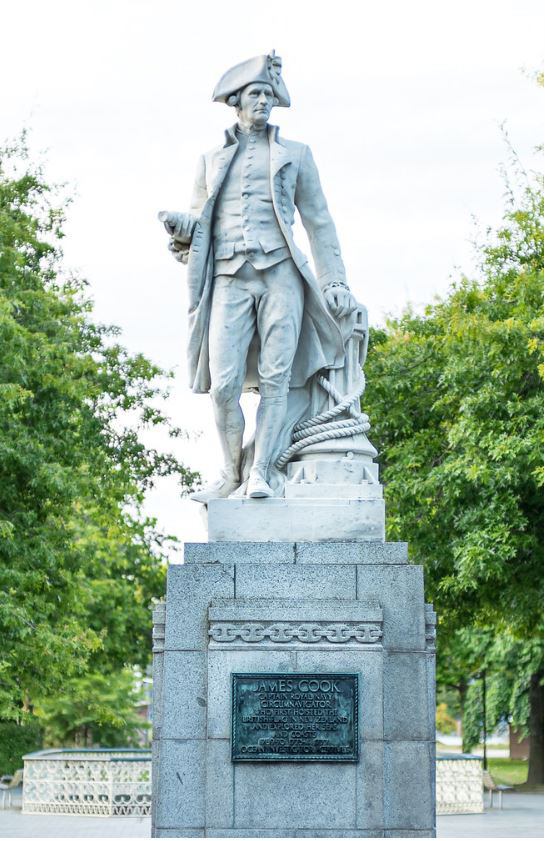
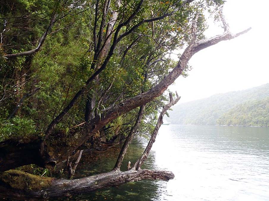
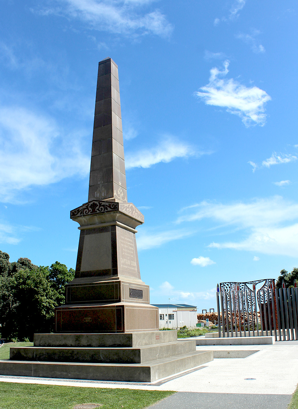
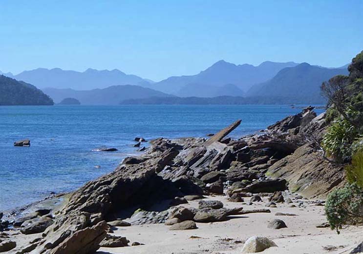
Sign up to hear more
Get the latest heritage news, features and events delivered
straight to your inbox.
