

Cambrians Historic Area is a collection of miners’ residences in an isolated hamlet that recall the nineteenth century gold rush origins of this area of the Maniototo. The history centres on the closely linked families, many with Welsh origins, who lived in the community. The houses, dating from the nineteenth and twentieth centuries, built of materials common to such gold mining settlements, recall the modest lives of miners in this harsh but beautiful area. Cambrians was established in 1863 around the mine workings in what became known first as Welshman’s Gully. The name reflected the Welsh origins of the first miners who settled in the area – including members of the Morgan, Owen and Williams families. By the end of that decade the miners had carved out a living on the land, mining both gold and the local coal deposits. When a post office opened in the 1870s, the name changed to Cambrians. Historic photographs show the early miners residences were typical of the Maniototo – sod houses, mud brick and lightly framed timber structures clad with corrugated iron. The community centred on the Welsh Harp Hotel and a couple of stores, the chapel and celebrated St David’s Day celebrations together. In the twentieth century, the community at Cambrians slowly dwindled away. Life was tough in the Depression of 1930s, although there was a brief revival of government-subsidised mining as part of the measures to combat unemployment. The Welsh Harp closed in 1918, the school closed in 1954 and the hall was dismantled and removed. By the 1960s many of the buildings that could be removed had been, leaving this cluster of houses. A few residents remained, but some of the houses were sold as holiday homes for Dunedin residents. And so a new history as a quiet holiday settlement came into being. Cambrians Historic Area consists of the surviving cluster of residences (and ruins) which recall the lives of the miners and their families in Cambrians. The ruins of the mud brick Welsh Harp Hotel stand alongside the associated residence. Several small mud brick cottages show the modest lives of the Morgan and Swinney families. The ruins of the Dungey family residence show the decline of the settlement in the twentieth century. In 2014, Cambrians remains a small hamlet of holiday homes and permanent residences.
Location
List Entry Information
Overview
Detailed List Entry
Status
Listed
List Entry Status
Historic Area
Access
Private/No Public Access
List Number
3207
Date Entered
4th April 2015
Date of Effect
5th May 2015
City/District Council
Central Otago District
Region
Otago Region
Extent of List Entry
This historic area consists of an area of land that contains a group of inter-related historic places. The identified historic places that contribute to the values in this historic area are the McGregor/Dungey residence (Former), Gay residence (Former), Robert Swinney residence (Former), William Swinney residence (Former), Haig residence (Former), Morgan residence (Former), Tom Morgan’s residence (Former), Cambrian School (Former), Welsh Harp Hotel and residence (Former). The area of land that encompasses these historic places includes the land described as part of Lot 3 DP 25142 (RT OT17A/1041), part of Lot 2 DP 25142 (RT OT17A/1040), part of Sec 4 SO 23818 (RT OT15C/403), Sec 126 Blk I St Bathans SD (RT OT2D/1398), Sec 132 Blk I St Bathans SD (RT OT4C/1458), Sec 135 Blk I St Bathans SD (RT OT5D/1353), part of Sec 115 Blk I St Bathans SD (RT 506736), Lot 2 DP 23469 (RT OT15B/849), Lot 2 DP 379923 (RT 320953), part of Sec 1 Blk I St Bathans SD (OT14A/486), part Legal Road (Cambrian Road), all Otago Land District (Refer to the map in Appendix 1 of the List entry report for further information).
Legal description
Lot 3 DP 25142 (RT OT17A/1041), Lot 2 DP 25142 (RT OT17A/1040), Sec 4 SO 23818 (RT OT15C/403), Sec 126 Blk I St Bathans SD (RT OT2D/1398), Sec 132 Blk I St Bathans SD (RT OT4C/1458), Sec 135 Blk I St Bathans SD (RT OT5D/1353), Sec 115 Blk I St Bathans SD (RT 506736), Lot 2 DP 23469 (RT OT15B/849), Lot 2 DP 379923 (RT 320953), Sec 1 Blk I St Bathans SD (OT14A/486), Legal Road (Cambrian Road), all Otago Land District
Location Description
The Cambrians Historic Area consists of a collection of residences mainly located on the south side of Cambrian Road. Cambrians is located off Loop Road, which runs between Becks and St Bathans in the Maniototo region of Central Otago. There are a few modern residences on Cambrian Road, but these are not included in the List entry.
Cultural Significance
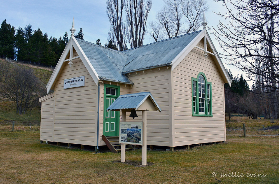
Social Significance or Value In 2014, Cambrians has a strong sense of community identity. The former school building, owned by the Cambrian Valley Trust, is a repository for local history and has a collection of family histories and photographs of the area. In 2014, it was one of the communities that joined to celebrate the 150th anniversary of the discovery of gold in this part of Central Otago.
Historic Significance
Historical Significance or Value Dating from 1863, Cambrians has significance as the ghost of the bustling settlement of Welshman’s Gully. Built around the mine workings in the neighbouring creek bed, Welshman’s was one of a number of Maniototo settlements to thrive then fade, representing the boom and bust of the gold rush era. Surviving into the twentieth century around gold and coal mining, a cluster of houses now represent the history of the close knit families that maintain their links to the area today. The history of Cambrians also provides a window into the Welsh cultural identity of many of the early miners.
Physical Significance
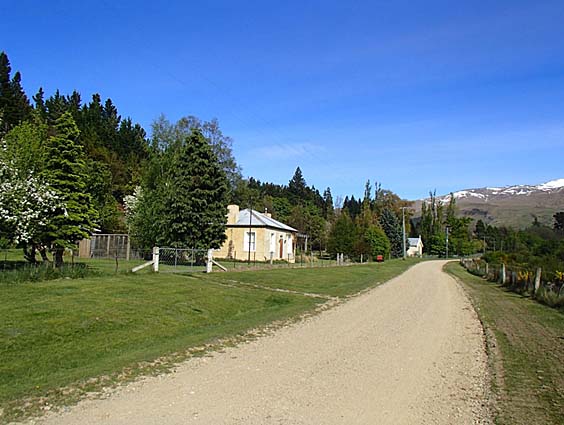
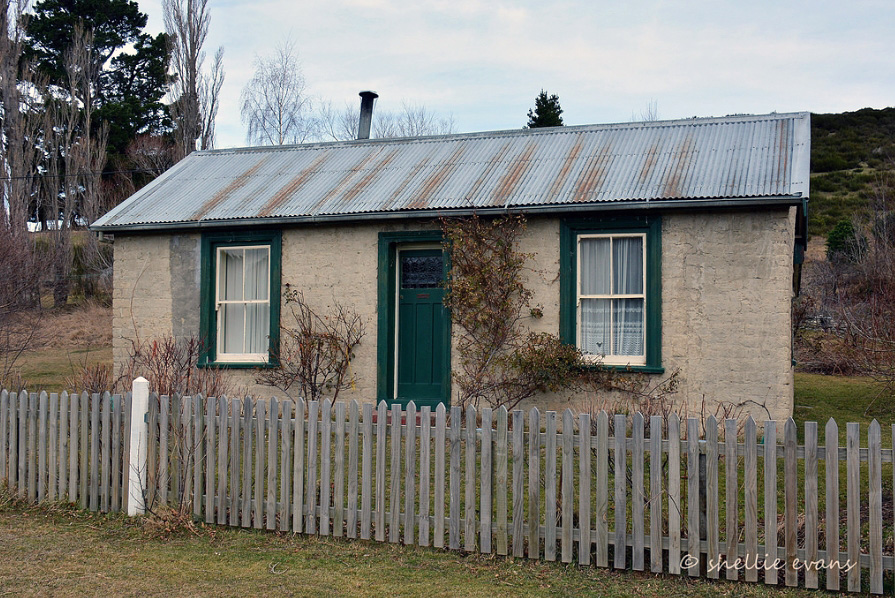
Aesthetic Significance or Value Cambrians is a hamlet set beneath the Dunstan Range. The houses are strung out along one side of the gravel road through the sheltered valley. The surrounding countryside has the characteristic bleak beauty of the Maniototo area. The houses are all small and built of the vernacular materials of this area – mud brick, corrugated iron and stone, and settle into the landscape. Across from the houses, visible through the covering of scrub and gorse, are the tailing and sluicing faces that recall the efforts of the miners who worked the land in this harsh and remote environment. The settlement has aesthetic significance. Archaeological Significance or Value Cambrians is a gold mining settlement dating from 1862. The settlement sits amidst an extensive network of mining remains – from tunnelling and hydraulic sluicing, to coal mining, and the remains of the once more extensive township. Cambrians Historic Area is part of an archaeological landscape relating to gold and coal mining in the nineteenth and twentieth centuries. Architectural Significance or Value The houses within the Cambrians Historic Area are representative examples of the modest nineteenth and early twentieth century residences typical of small gold mining settlements in the Maniototo. They are built of vernacular materials – mud brick, sod, corrugate iron and stone. There are cottages dating from the 1860s – Owen Owen’s residence built of corrugated iron with a mudbrick addition, William Swinney’s corrugated iron cottage and William Gay’s mudbrick cottage). There are cottages dating from the later nineteenth century and early twentieth century that illustrate the settled period of Cambrians’ history. Places such as the Welsh Harp Hotel ruins and the McGregor residence ruins show the decline of the settlement in the twentieth century. Several new residences constructed along Cambrian Road have been done so sympathetically. They are small and unobtrusive within the historic settlement.
Construction Details
Description
Mudbrick additions to Owen Owen’s House
Period
1940s
Type
Addition
Description
School closed and relocated
Start Year
1954
Type
Relocation
Description
Cambrian School Building shifted back to Cambrians
Start Year
2006
Type
Relocation
Description
Gold discovered in Dunstan Creek
Start Year
1861
Type
Other
Description
Owen Owen’s House constructed
Period
1860-9
Type
Original Construction
Description
Gold mining settlement established at Dunstan Creek. Becomes known as Welshman’s Gully
Start Year
1862
Type
Other
Description
Dungey Cottage built
Start Year
1871
Type
Original Construction
Description
Gay Residence built
Finish Year
1879
Start Year
1870
Type
Original Construction
Description
Second Hotel (Welsh Harp Hotel) built. William Swinney House built (circa 1879)
Start Year
1879
Type
Original Construction
Description
Welsh Harp Hotel Residence constructed
Period
After 1884 and before 1918
Type
Original Construction
Description
Cambrian School erected
Start Year
1885
Type
Original Construction
Description
Haig House
Period
1900
Type
Original Construction
Description
Swinney House built
Period
Before 1911
Type
Original Construction
Description
Welsh Harp Hotel sold and dismantled
Start Year
1918
Type
Other
Description
Morgan House built
Start Year
1922
Type
Original Construction
Construction Materials
Mud construction, stone, timber, corrugated iron
Maori had settlements in Central Otago, associated with early occupation – there were six settlements at Lake Hawea (Te Taweha o Hawea, Mahaea, O tu Purupuru, Turihuka, Te Taumanu o Taki and Pakituhi) and one near Cromwell (Wairere). The moa-rich area was known for camps where moa were butchered and cooked (for example there were large sites in the Hawksburn and Happy Valley areas, as well as the Nevis Valley), and there were quarries used for stone tools in the region of Tiger Hills and Mount Benger. The swampy plains in the Maniototo provided eels and other food resources. Though Maori are known to have joined the gold rushes, little is known about their participation in the gold rush at Cambrians. Cambrians is a small hamlet in the Manuherikia Valley area of Otago. Also known as Dunstan Creek, Welshman’s Gully and Cambrians (after the Welsh miners who settled the area), this was a busy mining settlement in the 1860s. The name derives from Cambria which is the classical name for Wales, being the Latinised form of the Welsh name Cymru. The settlement lies at the foot of Dunstan Range, about six kilometres from St Bathans. From 1858, pastoralists took up land in the Manuherikia Valley. The Lauder Run extended from the tops of the Dunstan Range to the Manuherikia River with the north and south boundaries being the Dunstan and Lauder Creeks. The run changed hands twice before 1860, and three times in the 1860s. Some of the land would be lost to the run when prospectors found gold in the area. Gold In the early 1860s, following the discovery of gold at Gabriel’s Gully, prospectors scrambled through Central Otago seeking gold. Prominent Waikouaiti merchant and businessman John (Johnny) Jones fitted out a prospecting party in December 1861. The party travelled through an isolated area in the upper Manuherikia Valley at the foot of the Dunstan Ranges. Prospector A.G. Reyman wrote to Jones, complaining that the party had been without food for three days, and that the runholder was refusing them food because he did not want gold diggers on his run. Reyman complained ‘we had nothing about grass roots for three days previously.’ Despite the hardship, the party of five men explored and found gold in a gully leading down to Dunstan Creek, and a deposit of coal nearby. Thomas Swinney was said to be the first person to arrive at Welshman’s Gully. Some of the prospectors stayed on at Dunstan Creek, with the Otago Daily Times reporting in August 1862 that the party had been living at Dunstan Creek for about nine months and had built themselves ‘a comfortable mud hut.’ The paper said that there was room for about 100 diggers, but that miners should be well supplied with ‘sluices and plenty of tools.’ Miners worked by tunnelling and paddocking, and then brought in ground sluices to wash out the gold bearing gravels. Welshman’s Gully A settlement grew up around the workings in what became known first as Welshman’s Gully, and later as Cambrian or Cambrians. By the mid-1860s, there was quite a settled community – in 1866, the Otago Witness reported that ‘Welshman’s Gully still continues a very prosperous community of miners. The tunnelling into the hills has given way to hydraulic sluicing, and very handsome returns are being made. The splendid seam of lignite discovered last winter has added much to the comfort of the residents. The most humble may now pass away his evening before a comfortable blazing fire.’ Cambrians differed from other gold mining settlements in that there were also deposits of coal, which were as important as gold. Benjamin Washer was the first owner of the coal pit. Later owners included John Jones and Ormond Hughes. Caleb Dungey/Dongee worked a nearby seam. Social and religious gatherings emphasised the Welsh identity of the Cambrians community. Comparatively few Welsh people emigrated to New Zealand; the Welsh were what geographer and historian Terry Hearn calls Britain’s ‘stay-at-homes.’ The gold rushes did however attract some people from Wales, particularly to the West Coast of the South Island, where they made up nearly four per cent of all miners. Other places in Otago did name themselves after their Welsh residents (Welshman’s Gully Switzers, and Welshman’s Flat in the Wakatipu area) but these places were not as well known. Cambrians was one of the most notable Welsh communities outside the Coast. The Welsh miners expressed their Welsh identity through their religious observance, their celebration of St David’s Day (1 March), place names and language. One correspondent wrote that the ‘miners are nearly all Welshmen, of a quiet turn of mind, hard working and sober.’ Cambrians’ sense of uniqueness had a particular neighbourly flavour given their affectionate rivalry with their near neighbours, the Irish Catholic St Bathans residents. While Cambrians’ residents celebrated St David’s Day, holding sports activities and other celebrations, St Bathans looked to St Patrick for their festivities. Cambrian By the 1870s, there was a nucleus of a settlement – stores, hotel, a church and school, although the town was never surveyed. An 1874 article noted that there were ‘several nice houses dotted up the Gully towards the coalpit, and a well-built wooden school.’ A post office opened in 1875 in Jones’ store. At this time, the name of Welshman’s Gully was changed to ‘Cambrian’ – a ‘euphonious name, suggestive of the Welsh origin of the place.’ The name change was necessary to avoid the mail being sent to Welshman’s Gully near Switzers. Another newspaper article railed against the name change from ‘my Welshman’s Gully to Cambrians, which is erroneous, as the ancient name of Wales was Cambria’ and Cambrians is neither an adjective nor a noun, and is just as sensible as to call Oamaru Oamaruanians.’ The miners and their families who lived at Cambrians held the land under mining tenure – occupation leases and residence area grants administered through the Warden’s Court. This makes the history of individual properties difficult to trace, particularly as some of the Warden’s Court records relating to residence areas for this locality seem to be lost. Electoral rolls give a little information on people’s residences: in 1875, Thomas Davies lived in a ‘hut of sod and iron’, Caleb Dongee and Edward Douglass each lived in an iron and timber cottage, Owen Owens lived in an ‘iron cottage’, Thomas Smart lived in an ‘iron & timber house’, Hy Smith lived in a ‘wooden & iron dwelling house’, Robert Sweeney lived in a hut of sod and iron, John Teague lived in an ‘iron & timber house’, and William Thurlow’s house was built of sod and iron. In 1879, William Clunie lived in a house of sod, wood and iron, Alexander Harley kept the Welsh Harp Hotel, Thomas Rowe lived in his sod, wood and iron house, while William Swinney’s house was built of timber and iron. Robert Swinney had a sod, wood and iron house. John Griffiths had a store of wood and Iron. These records show that early residences were small and built with readily available or easily transportable materials. Sod construction was common, as was the use of timber framing with corrugated iron cladding. These early residence areas, built before surveyed boundaries, developed in a haphazard way. Miners fenced the land as they needed and to fit their own purposes. Later surveys imposed more regular boundaries on the landscape. A 1931 survey of John Owen’s residence area, occupied by his parents probably at least since the 1880s, shows the fence lines around the houses, paddocks and the orchard, and the new parcel boundary imposed by the surveyor in the interests of regularity. This is likely to have been the case for many of these unsurveyed residence sites in Cambrians. The miners worked deposits in Welshman’s Gully and nearby on Vinegar Flat. Among them were John Morgan and Thomas Hughes who in 1874 established the ‘Vinegar Hill Hydraulic Sluicing Company Limited’. Between 1874 and 1899, they extracted over £20,000 of gold. The scarred landscape shows the workings of hydraulic sluicing and elevating in the area around Cambrians, and water races traverse the hills. The families of the original miners stayed on forming the backbone of the community. Their names appear through the years – the Morgans, Williams, Davies, Owens, Hughes, Harleys as well as the McGregors, Beatties. Dungeys (Dongee) and Gay family, among others. As a community, residents built the Victoria Hall in the 1870s or 1880s as a place to hold and gatherings. They funded the hall through shares in the building, proportionate to the amount each contributed – families still held these shares in the 1950s. The twentieth century As mining declined, locals looked to the land for their livelihood. William Thurlow, George Smith and Mr Pinton set about trying to identify land for ‘agricultural settlement’, arguing ‘a farm is the only genuine home. Gold is excellent as a means. It cannot be, and should not be, an end. ‘God’s acres’ constitute the only true nurseries of nature.’ But farming was not going to keep people living in Cambrians, especially in the tough years of the 1930s. In the early years of the twentieth century Cambrians still had a post and telegraph office, a school, hotel and Oddfellow’s Lodge. Slowly the services closed down. The Welsh Harp Hotel closed in 1918 and was dismantled and the building materials sold. The Victoria Hall, the community’s public hall and meeting place fell into disuse and was sold for removal in the 1950s. Mining slowly declined, with a brief revival in the 1930s under the unemployment prospecting schemes of the Depression era. The coal pit was still in open in the late 1940s. Historian Janet Cowan wrote that the pit was ‘said to be one of the most extensive lignite deposits in the province with good future prospects, while gold-mining has been almost at a standstill….’ But it could not keep the settlement alive. The school closed in the 1950s. The Stone’s Directory for 1950 lists the residents of Cambrians as John, Scobie and William Harley, Albert and Charles Harrex, David, John and Owen Jones, Albert McGregor, David Morgan, Harry Passmore, James Rutherford, James, Leslie and Neville Shaw, and George, Herbert, Leonard and Mary Swinney. The district field inspector for Crown lands wrote that there was ‘no demand for houses at Cambrians. Houses [are] being removed from this dead locality.’ When the hall was put up for sale the newspaper reported ‘[e]xcept for the few families with Welsh names who farm in the vicinity, the Welsh community has gone. The little town consists now of a half dozen sun-dried brick cottages, of which only two or three are occupied, and they by employees of the local rabbit board…There is a general air of desertion about the place, with piles of stones – the tailings of long-idle gold workings – adding their share of the desolation. Cambrians is another of Central Otago’s ghost towns, but its ghosts are Welsh and they sing in dialect, but no where [sic] more clearly than in the old hall.’ In the later years of the twentieth century, there was a quiet revival in the town, with some houses reoccupied as holiday homes, and a couple of new residences built. In 2014 Cambrians remains a quiet backwater with a mix of holiday homes and permanent residences.
Current Description Setting The area surrounding Cambrians is known for the extensive gold-mining claims during the 19th and early 20th century. The scarred landscape following the west side of Loop Road from Cambrian to St Bathans was created through the hydraulic sluicing and elevating gold-mining method that literally carved out the hillside and flats. In 1884, the gold-mining magnate of Otago John Ewing began to invest heavily in hydraulic sluicing at Vinegar Hill and Cambrian with £10,700 alone being invested at Vinegar Hill in the same year. Between 60-100 men were employed by Ewing at his Otago gold claims at any one time and included miners, race-men, stable-hands, blacksmiths and message-boys. Also mining in this area were the Chinese miners who would work over the already mined areas of the Europeans using the more basic machinery of pumps, cradles, pans and shovels. Gold-mining continued in this area (mainly at St Bathans) through to the early 20th century. Historic records regarding gold-mining around Cambrians are detailed where the names of actual gold miners who worked the various flats, creeks and streams are known. Although farming activities such as ploughing have destroyed areas of tailings, sluiced faces and tailraces around Cambrians, well preserved areas of gold mining are still present today that are a good example of hydraulic sluicing here during the nineteenth century. The large water races that cross the pastoral leases surrounding Cambrians were originally built for the purpose of gold-mining with some of these races used today for irrigation. Cambrians is located in the Manuherikia Valley in Central Otago. Cambrians is the remnant of a small settlement that grew up close to the gold mining workings around Welshman’s Gully and Vinegar Hill at the foot of the Dunstan Range. Like its near neighbours, St Bathans (a settlement still with its hotel, old post office and churches remaining), Drybread (of which the cemetery remains), and Tinkers (now Matakanui, with its cluster of mudbrick buildings), Cambrians recalls the bustling days of the gold rushes in the 1860s and 1870s when small towns sprung up to service the miners. Unlike Matakanui and St Bathans, no commercial buildings survive in Cambrians, and the only public building surviving is the school, shifted back to its original site. Like Matakanui, Cambrians is off the main road, both places giving a sense of being quiet relics of a busier past. St Bathans is more well known, and has a greater number of visitors. Cambrians grew up beside the mine workings on Welshman’s Creek. Cambrians Road runs the length of the settlement. In the nineteenth century, the buildings were strung out along the length of the road with the Welsh Harp Hotel marking the east end and Coal Pit Road stretching toward the workings closer to the foothills. The houses, store and hotel were largely located on the south of the road, with the workings on the north side. There were a few small residences on the same side of the road as the workings. The houses that remain are built of materials typical of gold mining settlements and of this area – mud brick, corrugated iron and stone. They represent the vernacular materials of the region and period. Also represented in the history of the Cambrians buildings is the typical adaptation of the buildings. Mudbrick buildings were extended as need demanded, the corrugated iron houses were added to (like the Owen Owens’ house with its mudbrick addition) or abandoned, like William Swinney’s house. The school’s relocation for use elsewhere and subsequent return is also a typical story of this region where timber was scarce. The ruins of the Welsh Harp Hotel are typical of the decay of mud brick buildings once the roof is gone. Materials were valuable and often reused – this is the story of both the Welsh Harp Hotel and the ruins of the McGregor residence at opposite ends of the settlement. The gaps in the teeth of the settlement are also typical as buildings were removed and used elsewhere – the teacher’s residence, for example, was removed. Such was the fate for other houses in the settlement. In 2014, the remaining buildings are dotted out along Cambrian Road, over about a kilometre. The houses are the remnants of the settlement, with old plantings, hedge rows and other archaeological material indicating the old house sites. There are several new residences along Cambrian Road but these are small and unobtrusive. The tailings on the north side of the road are overgrown with gorse and broom. The surrounding land is farmland. Sluicing faces and water races show how extensive the mining was. The Dunstan Range provides the backdrop for the settlement, which has a sense of being a forgotten place. Welsh Harp Hotel Ruins and associated cottage This cottage and the associated ruins of the Welsh Harp Hotel to the east are what remain of a complex of buildings associated with the hotel. Pierce and Washer seem to be the first owners of the hotel at Welshman’s Gully. They advertise in the Mount Ida Chronicle in 1870. Benjamin Washer advertised the ‘HOTEL, STORE, BILLIARD ROOM, Billiard Table, Stable and other Premises’ for sale in December 1870. Washer had been a storekeeper in Welshman’s Gully since around 1865. R. Jones (John Jones) bought the hotel and the adjoining store from Benjamin Washer in 1874. He planned alterations to make the Welsh Harp ‘one of the best up-country Hotels.’ The hotel and store burnt down in 1875. The hotel was rebuilt and was taken over by ‘Mr Beatty’ (formerly of ‘German Hill’) in 1879. Beattie, as his name was more commonly spelled, ran the hotel and butchery, and slaughteryard. Alexander Harley held the license for a period. An 1884 survey shows Beattie’s hotel, garden, stable and butcher’s shop on Section 1, with an application to purchase that land. Beattie’s title was issued in 1886, one of the few freehold sections in Cambrians. The residence does not appear on the 1884 survey, which suggests that it may have been built later. A license application in 1904 described the Welsh Harp Hotel as ‘containing 16 rooms, exclusive of those required for the use of the family.’ Frederick Haig took over the Welsh Harp Hotel from John Beattie in 1909 and held the licence until around 1914, when James Rutherford took over. In 1918, the hotel closed and its chattels and building materials auctioned off. The auction notice advertised five acres of freehold land with a ‘comfortable 4-roomed COTTAGE and garden.’ In addition, the building materials of the Welsh Harp Hotel were sold: ‘consisting of 561 sheets galvanised roofing iron (5ft and 9ft lengths), ridging spouting, and piping, 20 pairs window sashes, frames, and fittings, 24 doors and frames, register grates, mantelpieces, stoves and large range, bar counter, shelves, fountains, and panelled kauri ceilings, flooring, rafters, and studs, skylights, and large shop windows, Pelton wheel, sausage machine and tools’ as well as the furniture and effects. The buildings had been ‘carefully taken down’ to be sold in lots. In 1920, the land was transferred to Cambrians miner Joseph Morgan. In 1930 the property was bought by miner Cleaton Griffiths Davies. Davies held the land until 1946 when Dunedin miner David Jones bought it. The Dunstan Downs Rabbit Board bought the house in 1951. In 1961, the house was purchased as a holiday home. In 2014, the cottage remains a holiday home, while the piles of mudbricks to the east are what remain of the Welsh Harp Hotel. Cambrian School (Former) The first school, Welshman’s School, opened in 1873. Fundraising, including the St David’s Day picnic, helped pay off the debt. The school was renamed Cambrian School in 1878. A new and larger school building was built in the 1880s. E. Clark’s £504 3s 7d tender for the ‘Cambrian school and residence’ was accepted in October 1885. The school closed in 1954. The school building was moved to nearby Becks, where it housed the Sunday School of St Paul’s Union Church. The associated teacher’s residence was moved to Lauder Station and used as shearers’ quarters. In 2006, after the church closed, the Cambrian Valley Trust bought the building and shifted it back to Cambrians and its original site. In 2014, the school remains a meeting place and houses a collection of material on the history of Cambrians. It is open to the public. Morgan House (Former) Oral history records that this house was built for Tom Morgan and his family in 1922. Tom Morgan was a mine manager. He was the son of one of the original Cambrians settlers, Samuel Morgan. Thomas Morgan did have a residence site license for an acre on Cambrian Road in 1931. The house was described in 1964 as follows: there is ‘a sundried brick house on this property comprising sitting room, 2 bedrooms, kitchen, pantry and bathroom and fitted electric water pump, power and telephone. The house is quite sound.’ The Dunstan Downs Rabbit Board’s license for the property expired in 1964. In 2014, Tom Morgan’s former home remains a private residence. Owen Owens’ House (Former) This house was the home of another of Cambrians’ early miners, Owen Owens, and his family. The early portion (built of corrugated iron) may date from the 1860s-1870s. A mud brick addition was added to west side, possibly in the 1940s. The house sat on one acre that Owens probably leased as a residence area, as was the most common tenure for residential land within mining districts. The surrounding area was part of Lauder Station. Owen Owens had permission to fence off a further two acres from the station owners. This was another case of unrecorded early tenure, with the Cromwell Mining Registrar finding no record of Owen Owens ‘ever having a Residence Site License’, though he found earlier sites for Griffith Jones Owens and David Owens. Owen Jones Owens was born in Carnarvonshire in North Wales in 1830. He worked as a quarryman from the age of twelve at the Llamberis Slate quarries. He married Ann Jones from Bangor and after eight years together they sailed for Melbourne, where they settled at Stony Creek near Williamstown. When gold was discovered at Gabriel’s Gully in 1861 Owen Owens left his wife and sailed for Otago where he mined at Waitahuna and Gabriel’s Gully before moving to Clyde. Ann followed. After a year in Clyde, they moved to Welshman’s Gully. He and Ann raised a family of three sons and a daughter in Cambrians. The couple lived in this house until their deaths. Owen Owens died in 1911. Ann Owens died at Cambrians in 1917. After Ann’s death, her son John owned the residence area, letting it to Percy and Margaret Davies. John Owens intended to retire to Cambrians (he was working in Wanaka as an irrigator) but felt he was too old to make good use of the land, and sold the lease to the Davies family in 1933. He thought himself lucky to get the purchase price, as these were ‘hard times. Money is scarce.’ The Davies moved to Dunedin in 1947 and sold the lease to David and Joyce Monro. David Monro was a lecturer at Otago University and the family planned to spend the summer holidays at Cambrians. The transfer records that the house had five rooms, an iron roof and two chimneys. The outbuildings were a coal-house, wash-house and dairy. The Monros had to get an exemption from the residence requirement for licenses to occupy but as there was little demand for property in the region, this was no problem. In 1953, Section 115 was reserved for Rabbit Board buildings, and vested in the Dunstan Downs Rabbit Board. Presumably, the house accommodated rabbiters during this time. The gazettal was revoked in 1964, as the land was no longer required. In 2014, the house remains a private residence. Morgan House (Former) This small mudbrick cottage was likely to have been built for Bill Morgan, son of early Cambrians miner Samuel Morgan (brother of Tom who had a house at 101 Cambrian Road). Oral history information indicates that the house may have been built as late as the 1920s. Little else is known about the house. Haig House (Former) This mudbrick house was possibly the home of Frederick Haig and family. Frederick Andrew Haig had a one-acre residence site on the south west side of Cambrian Road in Cambrians in 1900. He had married the daughter of Thomas Hughes of Cambrians in 1898. Haig took over the Welsh Harp Hotel from John Beattie in 1909 and held the licence until around 1914. Jack Morgan lived there in later years. In the 1960s, the Dunstan Downs Rabbit Board owned the house, providing accommodation for rabbiters. It was described in 1964 as having ‘3 bedrooms, sitting room, kitchen etc., There is a fairly new extension to the house providing excellent washhouse, bathroom and toilet facilities. Electric power and telephone are installed’. Later the Electricity Department surveyor lived in the house. In 2014, it remains a private residence. Robert Swinney Residence (Former) This was the home of miner Robert Swinney. The original stone cottage is encased in later alterations which have seen the house rough-cast and the roofline altered. Robert Swinney died in 1917 and his wife Mary lived in the cottage. On her death in 1960, son Herb Seddon Swinney purchased the freehold of the residence area. He lived in the cottage until his death in 1981. Early photographs show a single gabled stone cottage with a mud brick lean-to to the east elevation. Robert’s daughter Violetta married Albert McGregor and lived in William Gay’s cottage. William Swinney’s House (Former) This small corrugated iron cottage was the home of miner William Swinney. Its corrugated iron and timber construction was typical of the first residences built by miners at Cambrians. In the 1879 electoral roll William Swinney is described as having a house of timber and iron. In the 1990s, the house was used as a garage. Inside were the remains of a ‘concave tongue and groove ceiling and some original wallpapers, hung on sacking which has been stretched over the corrugated iron. At least one old wooden fire surround remains and one six-light sash window, albeit in an advanced stage of decay.’ In 2014, Swinney’s old house is unoccupied. William Gay’s House (Former) This small mudbrick cottage was the home of miner William Gay. Gay lived in Cambrians from at least the early 1870s. The first reference to Gay in the Otago Nominal Index is in 1871. The first reference to his residence is to a ‘sod and iron house’ on leasehold land in the electoral roll of 1876-1877. Land records confirm that this section was granted to William Gay in August 1920 and that the section was assigned to Violetta McGregor in October 1929. Gay probably lived there before 1920, but it seems that many of the miner’s residences had no record of their tenure. The land was first surveyed in the 1930s. The next owners of the house were Albert (Bert) and Violetta McGregor. Bert McGregor was the son of Frank McGregor whose family lived across the road. Violetta sold the property to Dunedin factory foreman Allan Anderson and wife Audrey in 1973. In 2014, Gay’s old house remains a private residence. Dungey Cottage Ruin (McGregor Residence (Former)) This ruin was the home of miner Caleb Dongee (variously spelt Dungey, Dungee). Caleb Dongee had a coal lease in Welshman’s Gully in the 1870s, and applied for a residence area in 1871. Later it became the home of Frank McGregor and his family. In the 1930s the residence site license 4501, described as ‘one acre Crown lands situate north end of Cambrians and adjoining Main Road’ was granted to Helen Macgregor. It was granted in 1924 for a 42-year term. It is likely that the house fell into a ruined state when the roof iron was removed, probably during the Second World War.
Public NZAA Number
H41/252
Completion Date
11th November 2014
Report Written By
Heather Bauchop
Information Sources
Cowan, 1948
Janet. C. Cowan, Down the Years in the Maniototo: A Survey of the Early History of Maniototo County and Naseby Borough, Otago Centennial Historical Publications, Whitcombe and Tombs, Dunedin, 1948
Report Written By
A fully referenced New Zealand Heritage List report is available on request from the Otago Southland Area Office of Heritage New Zealand. Please note that entry on the New Zealand Heritage List/Rārangi Kōrero identifies only the heritage values of the property concerned, and should not be construed as advice on the state of the property, or as a comment of its soundness or safety, including in regard to earthquake risk, safety in the event of fire, or insanitary conditions.
Current Usages
Uses: Accommodation
Specific Usage: House
Uses: Civic Facilities
Specific Usage: Museum
Uses: Cultural Landscape
Specific Usage: Industrial/mining landscape
Uses: Cultural Landscape
Specific Usage: Streetscape
Former Usages
General Usage:: Civic Facilities
Specific Usage: Hall, Community
General Usage:: Education
Specific Usage: School
Stay up to date with Heritage this month
