

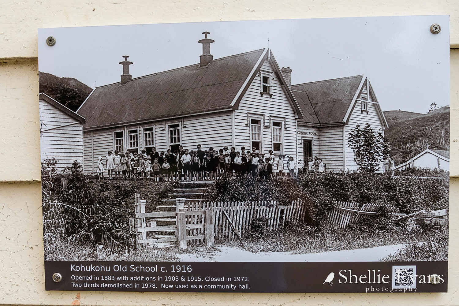
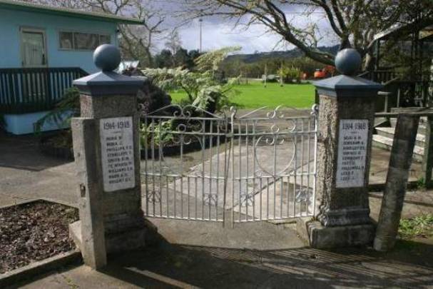
Kohukohu School was built on the corner of Kirkpatrick and Yarborough Streets in Kohukohu in 1883. It was built of kauri, with a kauri shingle roof originally. Rapid expansion of Kohukohu and surrounding districts, based substantially on the development of the kauri timber industry, caused significant increases in the school roll. A second classroom was added in 1902 and a third with some ancillary buildings in 1914. However, from that time on the growth of Kohukohu slowed considerably, and the school faced problems of maintenance rather than expansion. The hillside site provided very limited opportunities for playgrounds and other educational requirements of the twentieth century, and became increasingly unstable, requiring retaining walls and other earthworks. The place became increasingly unsuitable as a school and eventually a new school was opened on a nearby site in Beach Road in 1972. Community advocacy ensured the original classroom was retained as a community facility when the other buildings were demolished, and the former school was made an historic reserve. In the 1920s, a galvanised iron pipe rail fence was erected along the concrete retaining wall on the Yarborough Street frontage. Planning and fundraising for this and related work began in 1919, to replace the earlier fence, and the fence was probably in place by 1928. Much of it remains in place today. Probably at the same time, a Memorial Gate to commemorate eighteen former pupils from Kohukohu School who died in the First Word War was erected at the Yarborough Street entrance to the school, though planning for this began after December 1919. After the erection of the new school in 1972, the Memorial Gate was relocated to the entrance of the current Kohukohu School. The former Kohukohu School provides a record of the history of education in the Hokianga, from the time of the passing of the Education Act 1877. The relationship with the earlier Native Schools, the rapid growth of the town as the kauri timber industry boomed and then the decline of the school after the timber mills closed and the economy changed are all reflected in its history. The former Kohukohu School now plays an altered role in the community, but still provides a focus for many different Kohukohu activities and events.
Location
List Entry Information
Overview
Detailed List Entry
Status
Listed
List Entry Status
Historic Place Category 2
Access
Private/No Public Access
List Number
438
Date Entered
11th November 1982
Date of Effect
11th November 1982
City/District Council
Far North District
Region
Northland Region
Extent of List Entry
Extent includes the land described as Sec 126, Blk X Mangamuka SD (NZ Gazette 1984, p. 3527) and the building known as Kohukohu School (Former) and its fittings and fixtures including the iron railing fence. (Refer to map in Appendix 1 of the registration report for further information).
Legal description
Sec 126, Blk X Mangamuka SD (NZ Gazette 1984, p. 3527), North Auckland Land District
Cultural Significance
Social Significance or Value Kohukohu School has had social significance as a place of education and community gathering for over 120 years. Parents sought to ensure that the school in their community provided the best possible education for their children, and their efforts to do this provided a focus for community activity at several significant periods during the school's history. More generally, accounts of the school's history provide many examples of the school acting as a focus for community activity, in fundraising, in prize-giving, in sports activities and so on. The Kohukohu community made a significant commitment to saving the original school building from the threat of demolition in the 1980s, and continues to manage and support it as a community facility. While the social significance of the school has thus changed with its new use, it remains a vital part of the social fabric of the town.
Historic Significance
Historical Significance or Value Kohukohu School has historical significance as a representative example of a nineteenth century school and reflects the development of education in New Zealand in general and in the Hokianga from a period shortly after the passing of the Education Act 1877. The significant contribution made by small local populations to the sacrifice New Zealanders bore in the conflict of 1914-1918 is brought to mind in its relocated Memorial Gate. Kohukohu School was influenced by and therefore closely reflects the development of the town, and the Hokianga more generally. From the time that G F Russell's timber business in Kohukohu eclipsed the rival yard at Horeke in the 1840s, Kohukohu became one of the principal towns of the Hokianga. In spite of the brief setback caused by the depression of the 1880s, it developed on the back of the timber industry and subsequently butter production to be the commercial centre of the Hokianga by 1910. Together with Rawene and Opononi it was one of the three principal towns of the area. Although there continued to be some economic growth in the twentieth century, the town had reached its peak. The loss of young lives in World War One and the loss of buildings in major fires contributed to an economic decline that was only reversed in the 1970s, with the influx of new settlers into the town. The relationship with the earlier Native Schools, the rapid growth of the town as the kauri timber industry boomed and then the decline of the school after the timber mills closed and the economy changed are all reflected in its history. The establishment of the school following the passing of the Education Act 1877 undermined the pupil base of the earlier Rakaupara Native School, which closed soon after Kohukohu School opened in 1883. As the town and the population of Kohukohu grew, Kohukohu School grew with it, requiring a second classroom, added in 1902 as the timber mill was approaching its peak of production, and further buildings added in 1914, as the town reached the peak of its development. The significant impact on the town of the loss of eighteen young men is documented in the Memorial Gate erected at the school following World War One. As the town declined, the viability of the school came into question, with the physical deterioration of the school site happening, coincidentally, in parallel with the physical deterioration of the town, even though the school's problems were not the result of the fires that diminished the town. The town began to recover in the 1970s, but that recovery spelled the end for the school, which was closed after a new school was built on a much larger and more suitable site. However, the subsequent development of the town meant there was a need for community facilities, and pressure from the community led to the saving of the original portion of the school and its conversion to its current community organisation uses.
Detail Of Assessed Criteria
(a) The extent to which the place reflects important or representative aspects of New Zealand history Schooling is one of the most basic and universal experiences in New Zealand society. Kohukohu School is representative of the experience of many New Zealanders in rural schools in small country towns. Additions made to the school over time were subsequently removed and the original building remains in tact as a good, representative example of the typical one room school building from the late nineteenth century. (e) The community association with, or public esteem for the place The Kohukohu community has shown its high regard for this place over its entire history, as the centre for the education of its young people, and more recently as a centre for community events and activities. Over nearly 130 years the community has been a strong advocate for the school, initially for its establishment, and subsequently for its growth and development, for its maintenance and retention, for its survival after it ceased to be a school and for its ongoing community use. (f) The potential of the place for public education The history of Kohukohu School closely reflects the history of this important Hokianga town. In its current community facility role it has the potential to provide education and information to local residents and visitors about the history of the town that the school so closely mirrors.
Construction Details
Description
The World War One Memorial Gate is relocated to the new Kohukohu School.
Finish Year
1980
Start Year
1970
Type
Other
Description
Most of old school demolished, with the original 1883 building retained for community use.
Start Year
1977
Type
Modification
Description
Site in Yarborough Street Kohukohu purchased for a school
Start Year
1880
Type
Other
Description
20 April Kohukohu School opens in temporary premises on its site
Start Year
1881
Type
Other
Description
The first school building is erected and opened
Start Year
1883
Type
Original Construction
Description
The school is enlarged with the addition of a further classroom, attached to the first by their conjoined porches
Start Year
1902
Type
Addition
Description
A further classroom is added, together with extension of the porch, a storeroom, shelter shed and additional outbuildings
Start Year
1914
Type
Addition
Description
The World War One Memorial Gate is erected at the Kohukohu School
Finish Year
1930
Start Year
1920
Type
Other
Construction Materials
Kauri timber, kauri shingle roof (originally), corrugated iron roof.
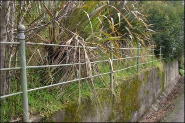
Kohukohu The Polynesian explorer Kupe returned to Hawaiki on his canoe Matawhaorua from Hokianga, providing one possible explanation for the name of the harbour, from the full name Te Hokianga-nui--a-Kupe, the great returning place of Kupe. In preparation for the return voyage his people made a hangi on the harbour shore, but they opened the oven before the food was cooked, and the food was cold. Kupe cursed them, and this place was named Kohukohu ('curse'). 'Place of mist' is another explanation of the name. Nukutawhiti re-adzed Kupe's canoe, which accordingly was renamed Ngatokimatawhaorua, and in company with Ruanui in the canoe Mamari sailed to New Zealand. The descendants of Nukutawhiti are Ngapuhi, while Ruanui's descendants are Te Rarawa and Te Aupouri. Te Rarawa occupied the northern side of the lower Hokianga, and land further north, while Ngapuhi occupied the southern side of the harbour, and expanded to the east. Whiria pa near Omapere was the birthplace of Rahiri, from whom Ngapuhi trace their descent. The first Pakeha to visit Hokianga were the missionaries Thomas Kendall and John King, who came overland from the Bay of Islands in June and July 1819. Lee comments that the only identifiable places they described are on the southern side of the harbour, which were more accessible than the settlements on the Kohukohu side of the harbour, and thus attracted more attention. 'Kohukohu gained prominence only after its occupation by Europeans'. The first Pakeha settler at Kohukohu was Captain David Clark, who bought a small parcel of land from Wharepapa of Te Ihutai hapu in 1830, after the shipyard at Horeke which he managed was sold to Thomas McDonnell by its owners Raine and Ramsay. Clark drowned in 1831. Frederick Edward Maning, an Irishman who had arrived in the Hokianga via Tasmania in 1833, bought Clark's land from Wharepapa in 1834. In quick succession Maning sold the land in 1837 to Dr Ross, who sold it to the Wesleyan missionary Nathaniel Turner, who sold it in 1839 to George Frederick Russell. George Frederick Russell came from Sydney in 1830 to manage the shipyard at Horeke, a successor to Captain Clark. Russell bought Turner's land in June 1839, established trading station in opposition to McDonnell who owned Horeke. Russell's business at Kohukohu soon eclipsed the Horeke business, and Kohukohu went on to achieve considerable prominence as the principal town of the Hokianga. Russell built the house in Kohukohu shown in Heaphy's painting of December 1839, and later Jolliffe's drawing of 1851. After his death in 1855 the house passed to his son-in law John Webster, then was sold in 1874 to Andrew C Yarborough. George Russell was a Pakeha witness to the Treaty signing at Mangungu on 12 February 1840. Andrew Cooke Yarborough came to Hokianga in 1871, and in 1873 set up a partnership in trading stores with Alfred Spry Andrewes. Yarborough's son and his daughter (who was later to become Andrewes' daughter-in-law) were later pupils at the Kohukohu School in the first decade of its operation. In 1874 Yarborough moved to Kohukohu and bought out Webster. Yarborough and Andrewes came to have substantial stores in several Hokianga towns. From the 1870s onward, Rawene on the southern side of the harbour gradually developed as the administrative and juridical centre for the Hokianga, becoming the county town after the passing of the Counties Act 1876. However, Kohukohu continued to make substantial progress economically, and the two towns were to be rivals on either side of the harbour for some time to come. The first hotel in Kohukohu opened in 1882, as the facilities of the town expanded. In 1881 Yarborough and Andrewes took over the timber mill that had been established at Kohukohu in 1879 by Greenfield and Stewart of Sydney, operated as the Hokianga Sawmill Ltd. The depression of the 1880s created hard times - the mill closed in 1886, but only briefly. In 1888 a group of Melbourne financiers bought out most of the surviving kauri mills in New Zealand, including Kohukohu, and formed the Kauri Timber Company, which became the dominant player in the industry from that time on. With the mill back in full production, Kohukohu experienced a growth in population, employment and town facilities. 1907 was the peak year for production and export of kauri timber, after which a steady decline set in. The Kauri Timber Company's Kohukohu Mill closed down in 1909, and was demolished in 1912. Many of the surviving kauri buildings in Kohukohu were built at that boom time from 1890 onwards. But prosperity continued. Kohukohu historian Eric Harrison has written: Kohukohu had grown from a village of perhaps fifty people in 1870, into the major commercial centre of the harbour, with over six hundred people in 1910. Kohukohu was built on the timber trade, but when the mill pulled out, it grew fat on butter. A new and more reliable industry was replacing the timber. The Hokianga Co-operative Dairy Factory opened its factory at Motukaraka in 1908. Hokianga now had two legs to stand on. The mills processed not just kauri but also kahikatea, puriri and tōtara. In a succession that was followed in many parts of the North, the land that had been cleared of its timber was converted to growing cows. The Hokianga Cooperative Dairy Company was established at Motukaraka in 1908. To export butter, it had to be packed in containers that would not taint it on its long sea voyage to London. Kahikatea was found to be an ideal timber for butter boxes. So King's mill opened in 1924 on the former Kauri Timber Company mill site making kahikatea butter boxes for Northland dairy companies, and others elsewhere. Kohukohu suffered significant losses of its young men in World War One. It suffered significant losses of its commercial buildings in major fires in 1922, 1937, 1954 and 1967. Eric Harrison wrote: Kohukohu was in decline, a trend that was not reversed until the early 1970s. Several businesses had closed down even before the dairy factory closed in 1957. Most of the younger people were leaving town. Kohukohu was becoming a place for middle aged and elderly folk. Kohukohu School From about 1874, a Maori ('Native') school was the only school in Kohukohu. It was situated at Rakaupara, at the southern end of Yarborough Street. The Education Act 1877 provided for free, secular, and compulsory education for all children aged between seven and 13, with Maori children given the option of attending either state or native schools. Pakeha children usually attended Native schools until their numbers justified the building of a state school. When Kohukohu School opened, three quarters of the pupils had previously been attending the Rakaupara Native School. Presumably for this reason, Rakaupara School closed in the 1880s. Kohukohu School opened on 20 April 1881 with sixteen pupils, and two more who enrolled the following day. Until the building was erected, the school met in temporary premises. The first school building was opened in 1883, on a site purchased three years earlier. The school had a shingle roof over its one large room with an entrance porch. The area was 928 square feet (86 square metres), which was said to be sufficient for up to 60 pupils. As the roll grew, the porch was extended, perhaps twice, in the 1890s. By 1902, the average attendance at the school was 86 pupils, but it was estimated that there were 112 school age children within three miles of the school. Accordingly, the Auckland Education Board applied to the Government for a grant to build another classroom at the school. The request sought £278, which as well as the classroom itself included provision for 30 desks, 10 forms, a bookpress, blackboards, easels, tables and chairs. The Government's first response was to ask if the school could avoid the expense. It was suggested a partition might enable the space, designed for 60 pupils, to accommodate its 90 pupils. The Education Board's response to this suggestion was to build the new classroom anyway, so that when the Government indicated it was prepared to make the allocation, the additional classroom had already been built. By 1914, the school roll had again increased substantially, reaching 139. 48 pupils from Standards 3 to 7 were taught in one classroom, while 63 primers were taught in the other. 28 pupils from Standards 1 and 2 were taught permanently in the porch. By August 1915, an extra room of 500 square feet (46 square metres) had been built, together with an extension to the porch of 150 square feet (14 square metres), a small store room, a shelter shed and additional outbuildings. As school historian Eric Harrison has commented 'Kohukohu was never cramped for room space again'. However, while classroom space was not a problem again, space on the site certainly was. The location for the school had been selected and the school built on a small site on a steep hillside, before playgrounds were considered a relevant aspect of a school. The total cost of building the school had been about £800, but many thousands were subsequently to be spent trying to stabilise the site. Parents began urging the necessity for improvements to the grounds. In August 1919 the school made application to the Education Board for a 1:1 subsidy on voluntary contributions raised at a concert, a dance and through sports subscriptions, to the value of £10. Sketch plans dated 12 December 1919 of 'Proposed Improvements at Kohukohu School' outline proposals to excavate the bank at the rear of the school, provide drainage, relocate a toilet, and provide a concrete wall along the Yarborough St frontage, surmounted by a fence. Contrasting sketches of the situation 'as it is now' and 'as it is proposed to be when built up' show a concrete retaining wall replacing an earth bank and wooden shuttering, with a fence with four rails on top of the concrete wall. What is probably a representation of the wooden gate shown in a 1920 photo ('as it is now') is replaced by a more elaborate single gate, with round balls on top of the gate posts. This has a resemblance to the War Memorial gate, but does not seem to show the War Memorial gate, which must have been a later idea. Records do not indicate whether this work was approved, or when it was implemented, but a distant photo of about 1928 indicates that the work had probably been carried out by that time. Movement of the hillside site caused problems both for the grounds and for the building. The first retaining wall, built in the 1920s, was already too late. By 1936, the asphalt was broken and had sunk in parts, with other parts pushed upwards by pressure from the hillside behind. By 1937 the school was unsuitable in several respects. Only two rooms were being used of what was described as a 'rambling old structure of three large rooms and two large porches'. Since the school was seen as certain to remain a two teacher school for the foreseeable future, it was suggested that it should be remodelled as a compact two-roomed school. Plans were drawn up to demolish the original 1883 building and half the porch, to build a staffroom and do essential maintenance. However, in summer 1938, the school at Rawhia further inland on the Waihou River closed. Because it was much closer by water than by road, the remaining pupils from Rawhia were ferried to Kohukohu to attend school. This meant the third classroom was needed again, and it was decided not to proceed with the demolition. Instead, money was spent enlarging the playing grounds. The school was seen to be in urgent need of repair, with sinking foundations and undulating floors. The school committee proposed that the building should be restored, or a new school built in a more suitable location. Nothing was done. A school dental clinic was erected in 1946, and in 1950 a 10,000 gallon (45,000 litre) septic tank was installed, with the effluent piped 300 yards (275 metres) out into the harbour. The quick action of a newspaper delivery boy prevented the school from burning down early one morning in October 1958. His swift action with a bucket extinguished the fire before it could do too much damage. It is suggested many in the community would have preferred that it had been left to burn down. In 1959, in spite of strong local advice, the Education Board bulldozed a new playing ground at the rear of the school. An enormous landslide resulted, filling the grounds with soil, trees and mud, and causing a substantial clean-up bill. In May 1962 serious flooding eroded the playing fields and damaged the drains. The floor level subsided some three inches (7.5 centimetres), so that various doors would not open (or close). In 1964, further ground stabilisation work was required. In 1966 it was decided to celebrate the 85th Jubilee of the school. It was completely painted, ceilings were installed to improve the heating, and the school was given a general 'spruce-up'. Over Labour Weekend 1966, some 600 people came from all over New Zealand to celebrate the event. Among those attending were 85 year old former Hokianga County and Hokianga Harbour Board Chairman Mr A G C Yarborough, who entered the school in 1884, almost at its inception, and his sister Mrs Mabel Andrewes, who enrolled in 1890. A total of nine pupils from the school's first decade attended. Between 1940 and 1969, there was protracted and continual lobbying to get agreement on a new school in Kohukohu. In 1969, as the Board appeared ready to renege on an agreed new school, a successful media campaign was mounted to embarrass the Education Board into action. Attention was drawn to the subsiding ground which constantly broke the drains from the toilets. There were large holes in wall and floors. A marble placed on the teacher's desk would drop to the floor, roll to the other end of the room and disappear from sight down a hole in the floor. The site was tiny, with less than half an acre (0.2 hectare) of playing grounds for up to 80 children. The headmaster described the school as 'a typical 19th century school erected when children were talked at and sport played no part in education'. Within a month of the campaign, repairs were undertaken, and negotiations started on a site for the new school. The site proposed was the 'Kohukohu Memorial Park', whose World War Two Commemorative wrought iron gates remain in place at the corner of Beach Road and Kohukohu Road. This site had originally been part of the harbour, the location of two timber mills, and consisted mostly of decomposing sawdust. It had to be raised seven feet with earth fill to allow the new school to be built. The new school in Beach Road was officially opened on 16 December 1972. The future of the old school was the subject of much community discussion, with several worthy uses being suggested for the buildings. However, the instability of the land and the drainage problems meant that offers for the site were not forthcoming. The Department of Lands and Survey offered the school to any group prepared to maintain and use it. When there was no response, the Department let a tender for the demolition of the school in 1977. At this point, the Kohukohu community decided that it should fight to save at least part of the old school. The Kohukohu Historic Society was formed and it was agreed that the original 1883 building should be retained, with the remaining later buildings being demolished. The kauri from the demolished buildings was incorporated into five new houses in Kohukohu. The original thought of creating a museum failed to eventuate. By 1981, a different group was formed to use the school as a community facility for a range of purposes: clubrooms, drop-in centre, music practice room, dance venue, yoga and exercise classes and training courses. In 1985, the Minister for Conservation classified the land as an historic reserve, set it aside as an historic reserve and formally appointed the Kohukohu Historic and Arts Society Incorporated to control and manage the reserve under the Reserves Act 1977. This wide range of community uses has continued, with several community groups involved, sometimes informally, in managing the building. Most recently, the Minister revoked the management by the Kohukohu Historic and Arts Society Incorporated and appointed the Kohukohu Conservation and Re-creation Society Incorporated to control and manage the historic reserve. Iron Railing Fence Photographic evidence suggests that the original fence around the school was a wooden picket fence. The circa 1920 photograph in the Kohukohu Library shows this particularly well in its dilapidated state at that time, while both the Vic Gurney photograph of about 1890 also in the Kohukohu Library and the Henry Wright photograph of 1894 in the Turnbull Library show it in good condition at those dates, albeit from a distance. There are a number of references in the Education Board files in National Archives to fund-raising for improvements to the school grounds between 1919 and 1924, and these include a 1919 drawing of a pipe fence. This sketch shows four rails in the fence, whereas the fence as built has only three. In February 1972, the Auckland Education Board's Building Supervisor wrote to the Board listing items at the old Kohukohu School that might be recoverable for reuse. He includes 'Item 9: Ornamental pipe front fence on top of roadside retaining fence (hacksaw off as complete unit and relocate at new school if desired).' Clearly this action did not occur, since the fence remains in place, but the Memorial Gate does appear to have been removed with a hacksaw. However, until very recently no reference had been found in any source, published, photographic or archival, to the World War One Memorial Gate that clearly formed part of this fence, before it was relocated to the present school, presumably in the 1970s. In response to newspaper publicity about this review, Joe Wilson of Taipa, who was a pupil at the school between 1936 and 1940, has produced a photograph his mother Francie Wilson took in 1940 showing the Memorial Gate in its original position.
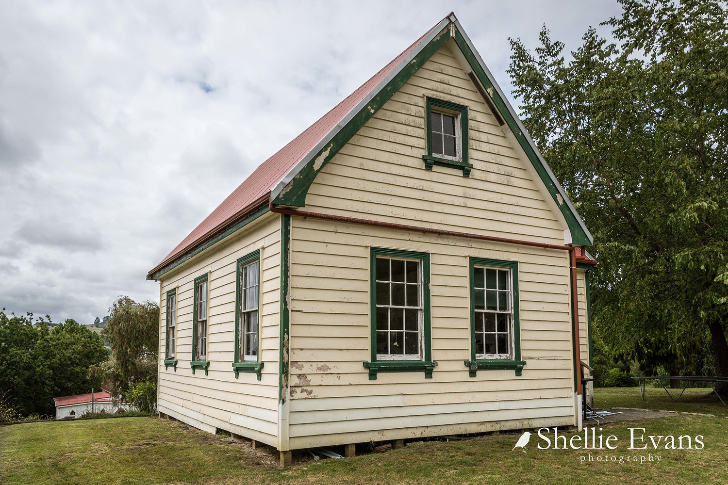
Kohukohu School Kohukohu School is situated on the corner of Yarborough and Kirkpatrick Streets, on the hillside overlooking Kohukohu township. It is almost opposite the Masonic Hall (NZHPT Record number 440). The former Kohukohu School comprises a large single classroom, which is the original classroom from 1883. It has an annex that is the remainder of the original porch, modified by the alterations, additions and removals of the building over time. The classroom has a gabled roof, aligned approximately west to east (in fact the eastern end faces a little south of east). A secondary gable at right angles to the main gable covers the annex on the southern side. The roof pitch is approximately 45 degrees. Although originally shingled, the roof is now corrugated iron, painted red. The classroom is a rectangular space some 9.2 by 6.2 metres. There is a fireplace located centrally in the southern wall, with brick firebox and simple wooden mantelpiece. No chimney now serves this fireplace above the roofline. Immediately to the east of the fireplace, a door provides access to the annex / porch, which is approximately 5 metres by 3 metres. The timber lined back of the fireplace and chimney protrudes into this space, which has been equipped as a simple kitchen with electric stove and sink bench. In the south-western corner a partition screens a toilet. There are exterior doors on the western and eastern ends of the annex. The western one is a four panel door, while the eastern one is a more recent tongue and groove single panelled door. On the southern wall of the annex there is a central 12-light double hung sash window, and to its west a small 4 louvre window providing ventilation to the toilet. The southern wall is a reconstruction, since the addition of the second classroom in 1902 would have required this wall to be removed to allow the two classrooms to be connected. The western and eastern walls each have two 12-light double hung sash windows at ground level, and a small 4 light pivoting sash window at high level. The northern wall has three 12-light double hung sash windows at ground level. The roof structure is exposed in the interior, with no remains visible of the ceiling recorded as having been installed in the 1960s. Rafters are supported on two bolted timber trusses. Purlins are fixed to the rafters, with tongue, groove and reeded sarking running vertically. The walls are timber framed, with overlapping horizontal nine inch (225mm) weatherboards on the exterior. The interior walls are lined with tongue, groove and reeded horizontal boards. The floor boards are tongue and groove, oriented along the long axis of the building. There are simple wooden cupboards, probably of relatively modern date, along part of the southern wall of the classroom. Iron Railing Fence The iron railing fence consists of 16 vertical up stands of galvanised iron pipe, two and quarter inches (6 cm) in diameter, set into the top of a concrete retaining wall running along the Yarborough Street (eastern) frontage of the site. Although there is slight unevenness, each pipe rises some 97 cm above the surface of the wall. Of this, the top 14 cm is formed by a spherical knob and cylindrical collar. Each is attached to the pipe by a screw thread. Drilled through each up stand at 10 inch (25 cm) centres are three horizontal holes. These allow the uprights to be connected by three fence rails made of three quarter inch (2.3 cm) galvanised iron pipe. The up stands are not evenly spaced, with distances varying from six foot nine inches (2.44 metres) to eight foot four inches (2.55 metres). The galvanised iron pipe of the posts, rails and knobs bears traces of dull green paint. As would be expected, this is generally better preserved on the vertical elements than the horizontal ones. At the southern end of the school property, the last up stand is about a metre away from the end of the concrete wall. It has three holes on its southern side, but only the sawn off end of the rail is visible in the hole. At the end of the wall on the ground there is a formed kerb either side of the path that leads from the road up the slope of the section towards the school building. Between these kerbs, there are two 19 inch square concrete footings. The retaining wall on which the iron pipe fence stands is referred to in the Auckland Education Board papers from the 1920s in Archives New Zealand. Its construction resulted in a major reconfiguration of the Yarborough Street frontage of the site, with the much gentler original configuration clearly shown in the circa. 1920 photograph of this frontage.
Completion Date
4th April 2010
Report Written By
Stuart Park
Information Sources
Harrison, 1983
E Harrison, Kohukohu, 1983 [Kohukohu Historic and Arts Society]
Lee, 1987
Jack Lee, Hokianga, Auckland, 1987
Harrison, 1981
E Harrison, Kohukohu 1881 - 1981: the District and the Schools, 1981
Report Written By
A fully referenced registration report is available from the NZHPT Northland Area Office Please note that entry on the New Zealand Heritage List/Rarangi Korero identifies only the heritage values of the property concerned, and should not be construed as advice on the state of the property, or as a comment of its soundness or safety, including in regard to earthquake risk, safety in the event of fire, or insanitary conditions.
Current Usages
Uses: Civic Facilities
Specific Usage: Hall, Community
Uses: Civic Facilities
Specific Usage: Wall/Fence
Uses: Commemoration
Specific Usage: Memorial - World War One
Former Usages
General Usage:: Civic Facilities
Specific Usage: Wall/Fence
General Usage:: Commemoration
Specific Usage: Memorial - World War One
General Usage:: Education
Specific Usage: School
Themes
War Memorial
Stay up to date with Heritage this month
