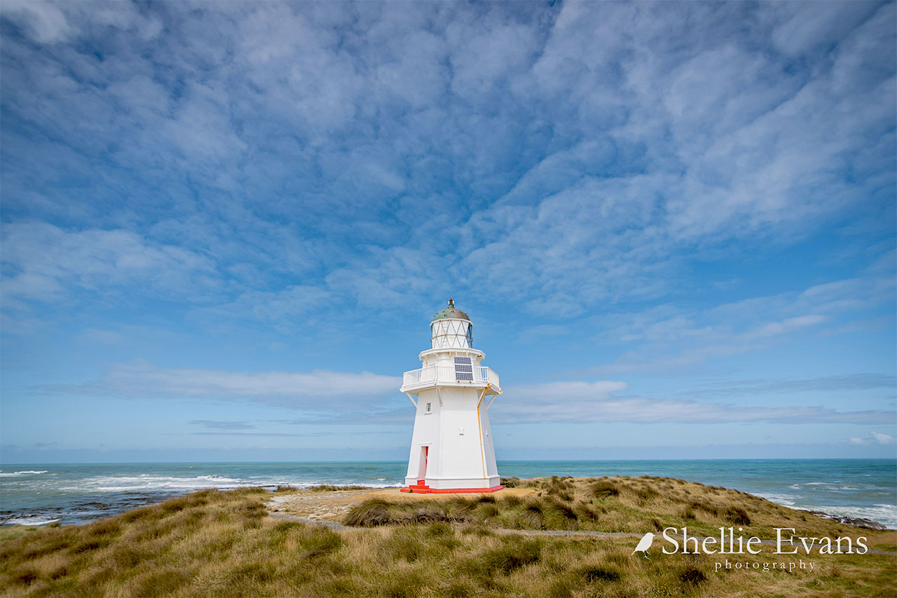
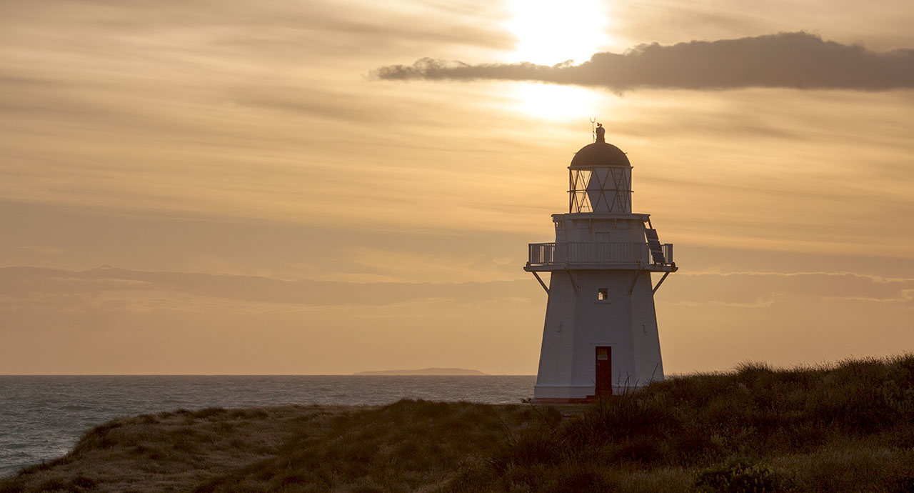
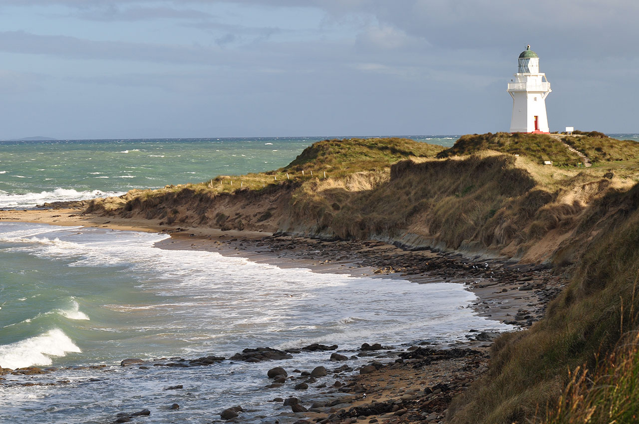
The SS Tararua Wreck Site, the associated cemetery, the Tararua Acre, and the Waipapa Point Lighthouse (the Lighthouse), constructed to light this dangerous part of the coast, are located east of Invercargill at the head of Toetoes Bay. The Lighthouse is located close to the Otara Reef that was the site of New Zealand's worst civilian shipwreck. The Union Steamship Company's SS Tararua hit the reef on 29 April 1881, at the cost of 131 lives, and with only 20 survivors. Around 64 bodies, some unidentifiable, were buried at the Tararua Acre, about a kilometre down Waipapa Beach. The Lighthouse was constructed in recognition of the danger of this piece of coast, and the light was first lit on 1 January 1884. In 2008 the Lighthouse still sends its beam out to sea, though this is an automated service, with the last keeper withdrawn in 1976.
The southern coast around Foveaux Strait was rich in resources and occupied by iwi, as evidenced by the number of archaeological sites recorded, reflecting the lives of Ngai Tahu ki Murihiku. Waipapa Point is identified as a Wahi Taonga, a special place, in the Te Whakatau Kaupapa o Murihiku. The waters surrounding Waipapa Point were breeding grounds for marine species and were a major source of food and related resources. Te Ara a Kiwa/Foveaux Strait Kiwa was the ancestor who travelled around this coastline, traversing the isthmus that then joined Rakiura and Murihiku. Kiwa requested that Kewa (the whale) chew through the land, and the crumbs that fell from his teeth are the offshore islands. The area is of 'huge cultural significance' to Ngai Tahu Whanui. An Ara Hikoi travelled along the coastline from Waikawa to Curio Bay where Maori made use of the abundant resources, living and passing through the area on the south east coast.
The Foveaux Strait area was first occupied by Europeans during the sealing industry in the late 1700s which lasted through to the 1820s; the first observation of Maori occupation comes from around this time. A 'large old' settlement was recorded at the Toetoes in 1827. By mid 1830s the Mataura Mouth whaling station, just west along the coast from Waipapa was occupied, but this and the associated population had declined by the late 1830s as settlement was concentrated in central Foveaux Strait.
The area around Waipapa, called Otara, was also the site of a short-lived whaling station worked by James Wybrow. According to local information, the proper name of the point where the lighthouse stands is Otara, and was part of the trail used by Maori travelling up and down the coast. The Tokanui River and mouth nearby have associated burials and taonga, and the archaeological sites in the vicinity are testament to the Maori activity in the area in the past.
That the coast was hazardous was also clear as there was a report of a whaler Sandy Low being wrecked at Waipapa Point in the mid 1840s. After the whaling stations were closed the whalers retired to a more settled existence on the land, forming the nucleus of early settlement with their often Maori families.
The Catlins Coast was part of the 1853 seven million acre Murihiku purchase negotiated by Walter Mantell, and after this time more European settlers arrived, and a corresponding increase in sea traffic.
Pastoral stations were established in the 1850s, with Harry McCoy taking up the Otara Run, which was taken over by William Reynolds later in that decade. Reynolds had a homestead at Waipapa. The Run was taken over by Major Brunton and sons in the mid 1860s.
Lighthouse construction was controlled by the Marine Department from 1866. With the enormous seaboard and numerous capes and headlands provision of navigation lights was vital to New Zealand's coastal shipping, and in southern New Zealand lights at Dog Island, Cape Saunders and Taiaroa Head in the 1860s. James Balfour, who had designed the stone lighthouse at Dog Island, was appointed Marine Engineer and adopted a policy of erecting timber lighthouses as they were quick to construct, and the materials relatively easy to transport. After his death in 1869, this policy was continued through the 1870s and into the early 1880s by John Blackett and Captain Robert Johnson. The 1870s was the peak decade of lighthouse construction in New Zealand. Twenty five lighthouses were built during this period, and a further six in the 1880s, including the one at Waipapa. The last of the lighthouses completed during this period was the Kaipara North Head light. In the later nineteenth century other towers were completed, for example Stephens Island, Cape Palliser and Mokohinau, but these were constructed of stone or cast iron.
Marine engineer John Blackett directed the programme of works until 1889 and by the end of the nineteenth century the Marine Department had commissioned 16 manned lighthouses. Blackett was marine engineer for the general government from 1871-1889, chief engineer for New Zealand from 1884-1889. Blackett drew on his North American experiences and designed wooden towers, with a double wall filled with rubble to a height of around 10 ft (3 metres). The Kaipara North Head Lighthouse is of a similar design. This method of construction allowed easily transportable wood to be used, with the ballast coming from stone. Sites for lighthouses were based on recommended locations drawn up by Captains Robert Johnson and Robert Edwin, but circumstances could add another site to the list. The Waipapa Point Lighthouse was built on tragedy: the loss of the SS Tararua off the coast of Southland in 1881.
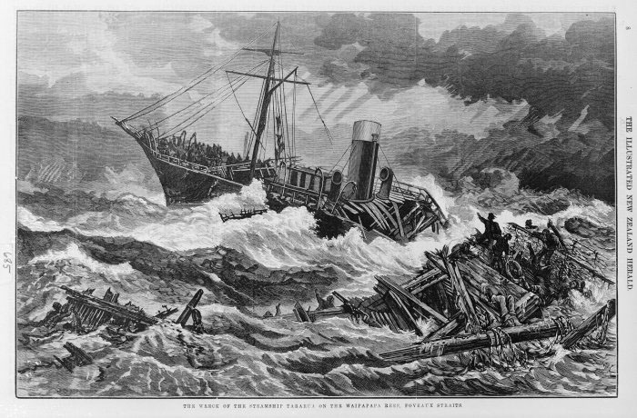
The tragic wreck has a special place in New Zealand's history. A record of 200 years of shipwrecks in New Zealand waters records that '[f]ew, if any, wrecks on the coast of New Zealand have been attended by such tragic incidents as those connected with the loss of the steamer Tararua.' The SS Tararua was on a voyage between Port Chalmers and Melbourne. On its journey south the sound of breakers was heard in the 5am darkness, and the captain recognised that the ship was too close to the rocks. After a failed attempt to turn the ship out to sea, the rudder and propeller were broken, and attempts to launch the lifeboat saw that craft holed. Passenger George Lawrence made it to shore, raising the alarm, and there was a flurry of telegrams trying to identify what assistance was required. The message was relayed inland but did not reach Dunedin until midday, and was not marked urgent, so no action was taken, and indeed it was reported that all lives were safe. There were several unsuccessful attempts to reach the shore with passengers swimming from the lifeboats, some made it, but others drowned under the watching eyes of passengers remaining on the ship. Only the ship's cook, a Maltese man and a strong swimmer, survived a swim from ship to shore. By the early afternoon the ship was breaking up in roughening conditions, and 12 hours later the ship broke up and sank with the loss of the 131 men, women and children still stranded.
Ingram's New Zealand Shipwrecks describes the tragedy:
‘A particularly heavy sea swept over the forepart, and nearly a score of people were washed overboard... Towards evening those still surviving were forced to take refuge in the rigging, and on one occasion were heard cheering by those on shore, it was supposed at the sight of the steamer Kahanui steaming from Bluff. Up till 11pm lights in the rigging were occasionally seen, as though matches were being burned. At 2.35am on April 30 the closing tragedy in the disaster occurred. Those on the beach heard the piercing shrieks from the doomed people on the Tararua, and a voice, said to be that of the captain, calling for a boat, which could not be sent, as the chief officer's boat was damaged when it capsized, and could not be repaired. At daybreak the steamer had sunk almost out of sight, and bodies were coming ashore.'
Members of the Fortrose community turned out in force to give assistance: but there were few survivors. Local man James Wybrow, with a rope looped around his waist and anchored on the shore recovered bodies from the surf, suffering much afterwards from nightmares. The first dead were taken to Fortrose, where once identified, and coffins been made, they were transported to Edendale to be taken north by train.
Bodies continued to be washed ashore, but deteriorated rapidly. It became impracticable to shift the remains far from the wreck site. Sixty four bodies, many unidentifiable, were buried at a nearby plot of land, known as the Tararua Acre, surveyed by the Government surveyor and set aside as a burial ground. Local carpenters worked day and night to build coffins. The remains were numbered and any details recorded on an official record before burial. Heavy rails were put at the head of the plots with the numbers set in wood. Later paling fences were erected around the plots, with plans supplied by architects McKenzie and Gilbertson of Invercargill.
New Zealand papers printed extra editions to meet the public demand for news: 7000 extras were sold of the Otago Daily Times.
A Court of Inquiry in Dunedin in May 1881 blamed Captain Garrard for the loss of the vessel, for adopting a course too close to shore, not checking position, and for not getting the passengers into life boats.
The Court of Inquiry recommended a light be erected on the point. A site was selected in December 1881; work began on the construction of the wooden tower and houses for three keepers and their families. The lighthouse reserve of 200 acres was gazetted as a permanent lighthouse reserve on 9 April 1882. In July 1882 the Public Works statement reported that the site had been selected and that orders had been placed in England for the light apparatus and lantern. The local newspaper indicated that it was not until November 1882 that the Stella was expected to leave Wellington to deliver construction materials to Waipapa, with confirmation of the delivery at the end of December. The delays did lead to criticism that there should have been a temporary light in place while the permanent structure was built.
According to Maritime New Zealand, the Lighthouse was the second to last wooden lighthouse tower to be built in New Zealand. More than 10 timber lighthouses had been built prior to the one at Waipapa, including towers at Brothers Island in 1877, Moeraki in 1878 and at Akaroa Heads in 1880. Kaipara North Head Lighthouse, of identical design to Waipapa Point Lighthouse (with its vertical timber cladding) was completed on 1 December 1884. The Court of Inquiry's recommendations were a turning point in maritime safety: from 1882 lifebelts had to be provided for every person on board a ship, and crews were to regularly practise life boat evacuations.
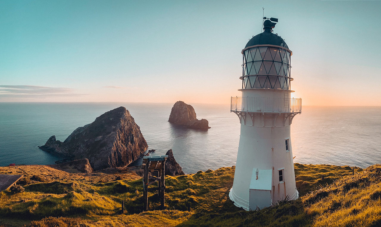
Mr Wilson of the Marine Department reported the successful opening of the Lighthouse on the 1 January 1884: ‘lighted up last night; everything right.' The Lighthouse is a double-skinned wooden structure, built of kauri and totara. The wall sections have a ballast of rock filling. The tower is 44 ft. high. The cost was close to £6000, with an annual maintenance cost of between £300 and £400. The lighthouse keepers also maintained the Tararua Acre, where some of the dead from the wreck were buried.
The Waipapa Point light keepers' houses were built at the same time as the Lighthouse. The houses suffered from exposure to the severe weather of the area, with the maintenance records reflecting this.
The original layout of the lighthouse station is shown in an 1889 survey plan. The plan shows the lighthouse and its associated structures: a signal staff, store, oil store, landing store and two houses in a fenced enclosure.
In 1886 the Southland County Council was appointed Trustee for the Tararua Acre under the Cemeteries Act. As early as 1882 there was concern about the condition of the graves and requests for an appropriate memorial. In 1899 the Government paid the Council £50 to be held as a fund for the future maintenance of the cemetery, and for many years the Council did supply paint and repair materials for the cemetery. The provision of a monument had been a project of the Tararua Disaster Committee, but it was the local school children who first raised funds for memorial headstones to the victims of the wreck. One was erected in the Fortrose Cemetery, the other at the Tararua Acre. For many years the anniversary of the wreck was marked by the local school which placed flowers on the graves.
While the new Lighthouse reduced strandings on the point there were still significant incidents. In February 1891 the keepers came to the aid of the Star of Erin, which struck the reef and was lost. All hands were saved.
In the 1890s the first salvage attempt was made on the SS Tararua. Various syndicates of divers attempted to bring up the silver coin known to have gone down with the ship. Other material washed up on shore was reused by locals; furniture, timbers for construction and the like were treasured, recalling the sad event.
A 1901 newspaper article in the Otago Witness describes the Lighthouse of ‘considerable importance.' The light apparatus was composed of ‘glass lens and prisms' of ‘second order dioptric' and ‘flashes a white light every 10 seconds, visible 13 miles out to sea.' The light made eight flashes every revolution, each revolution taking 80 seconds. On a summer night this amounted to 2880 flashes at intervals of 10 seconds, while in winter double this number were sent out. There were two keepers at the station on four hour shifts. ‘At the foot of the lighthouse cliff there are a number of reefs extending out a long way from the shore, and in fair weather these do not show any sign of danger, but in stormy weather the sea for many miles is nothing but a mass of frothing and foaming billows, thus indicating the shallowness of the water and the consequent danger to shipping.'
In 1909 the Commissioner of Crown Lands wrote to the Southland County Council about the state of the Tararua Acre urging the Council to remedy the neglected condition of the cemetery. Concerns were regularly expressed in the local paper into the 1950s. The Otara Women's Division of Federated Farms also drew attention to the poor state of the cemetery, campaigning for funds for its maintenance. A 1959 article in the New Zealand Truth lamented the state of the significant site: ‘No gorse...grows over the Tararua plot which originally was surrounded by a wooden fence which is now mostly broken down. The grave of only one Tararua victim is marked by a stone. The lead lettering is coming off it. Possibly because of the sandy nature of the ground the memorial stone to wreck victims has tilted like a wreck itself.' The article also noted that the engine and the boilers of the wreck were visible at low tide.
In 1960 the Council draughtsperson drew up a new plan, showing the original sites of the mass graves and the private plots, and arranged for the cemetery to be cleared. The National Historic Places Trust (now New Zealand Historic Places Trust) was approached for assistance for appropriate markers for the cemetery, and a bronze plaque was funded by the Department of Internal Affairs. A memorial cairn was planned to be set over the largest plot, and the smallest plot to be marked by concrete pillars. The fallen stones were to be reset. The cairn was set with Queenstown stone, and completed by local contractor Albert Poole.
A general programme of electrification of lights began in the mid 1930s, at first using diesel generators to power electric lamps, which no longer needed attendance during the night from keepers. The light at Waipapa was electrified in 1943. The Lighthouse was the first station to be connected to the national grid. Problems with salt spray on the transformer, fuses and lines caused many power outages. This was solved by burying the lines.
In 1949 legal access was provided with the construction of a road. A 1949 aerial photograph shows the lighthouse and the associated tracks and structures. The houses and stores are evident, along with shelter belt planting and garden enclosures.
By the 1970s new technologies were reducing the importance of lighthouses, as satellite navigation systems began to be installed on ships, weather reporting became automated, and faults at lighthouses could be remedied remotely. The final stage of automation was demanning the manned stations, with keepers sent a circular in 1973 informing them of proposed changes. In 1976 the light was automated, and the keepers withdrawn. The associated buildings (lighthouse keeper's house, single men's quarters, garage and sheds were demolished).
The Marine Department would have liked to have made the tower surplus to requirement in the early 1970s, with a preference to construct a smaller low cost structure. The tower was offered to local parties, including NZHPT, but all refused ownership, preferring that the Marine Department continue to maintain the tower.
The Lighthouse was recognised as unique by the Ministry of Works. The Commissioner of works noted its uniqueness, but noted it was expensive to maintain because once the station was demanned there was no local accommodation for the painting gang. He considered that the Marine Division was ‘in no position to maintain items of possible historic interest which have outlived their period of usefulness.' Beaglehole notes that the Commissioner had little patience with the Historic Places Trust or ‘locals with parochial attitudes.' The tower was saved because if local pressure prevailed and the tower was maintained, it was too expensive to build another nearby as well.
The light was solarised in 1988.
Repeated attempts were made to recover the silver bullion on board the Tararua. Salvage attempts had been made straight after the wreck, and in 1889, but it was not until 1970 that divers salvaged the brass and copper fittings and ship's souvenirs. Although the wreck was privately owned (by author Joan Macintosh, and has since changed hands but remains in private ownership), the pirating of the wreck continued. Subsequent attempts to salvage the silver failed.
In 2000 the wreck of the Tararua featured on TV One's Shipwreck series (and in the subsequent publication), which told the story of eleven wrecks. Once again the profile of the tragedy was high in the public imagination.
In February 2007 Maritime New Zealand issued a fact sheet providing information about their restoration plans for the Lighthouse. Maritime New Zealand recognising the significant heritage value of the Lighthouse were trialling various finishes to combat the rust streaking of the building, and was also working through other issues with the place including a significant problem with vandalism. Repair work was begun in 2008, and was still in progress at the time of writing.
In August 2007 the Department of Conservation, which manages the recreation reserve surrounding the Lighthouse, held a public meeting to discuss the future redevelopment of the Waipapa Reserve, one of the most popular Department of Conservation managed sites in Southland. The Department of Conservation wished to put in walking tracks, a car park and to privatise the road to the Lighthouse (with the aim of reducing vandalism, by limiting vehicle access to the area close to the lighthouse), and to improve visitor facilities.
In January 2008 a site survey of the Waipapa Point Recreation Reserve (excluding the lighthouse) was undertaken for the Department of Conservation to identify visible archaeological sites, map features, to make a photographic record and to provide a management report.