Arthur’s Pass village and Arthur’s Pass National Park reflect the history of transportation and trade and the progress of transport methods to traverse the South Island. Passes over the Southern Alps / Ka Tiritiri o te Moana were known to Maori as part of a network of trails to carry pounamu (greenstone) from the West Coast to the east. The most commonly used pass connected the headwaters of the Hurunui and Taramakau Rivers, known to European settlers as Harper Pass (named for himself by Leonard Harper, the first European to use the crossing). Te Tarahaka o Kaimatau ran between the headwaters of the Otira and Bealey Rivers and was a steeper and more difficult pass reputedly used by more agile travellers. Temporary settlements and mahinga kai (food gathering areas) and were known along the route and food resources included weka, kakapo and edible plants. Knowledge of a route between the Otira and Bealey Rivers was told to surveyor Arthur Dudley Dobson (1841-1934) by Ngati Waewae rangatira Tarapuhi (Poutini Ngai Tahu). Dobson rediscovered this route in March 1864 and it became known as Arthur’s Pass.
In the early 1860s the Canterbury Provincial Government (whose territorial authority at that time encompassed the West Coast) endeavoured to improve communications between the east and west coasts. A track over Harper’s Pass had been used by European settlers since Harper’s first crossing in 1857, but was a long and difficult journey. The Survey Office instructed its staff to explore suitable routes over the Alps, intensified by the discovery of gold on the West Coast in 1865. In February 1865 Arthur Dobson’s brother, George, was instructed to inspect the route discovered by Arthur and to assess its suitability as a road. George Dobson found the route to be impracticable as a road, but despite this a survey of Arthur’s Pass proceeded, led by Arthur and George’s father Edward Dobson as Provincial Engineer for Canterbury. Construction of the road immediately followed and the road from Christchurch to Hokitika was opened for traffic on 20 March 1866.
The Coach Road was immediately in use for regular passenger and mail services operated by Cobb & Co. Although the discovery of gold on the West Coast was the final impetus for the construction of the road, it was only used once for the gold escort, coastal shipping being a more cost-effective and quicker option. Hotels and staging posts were established along the route and the settlement of Camping Flat (later known as Bealey Flat) was formed at the area now know as Arthur’s Pass village.
The development of the timber and coal industries on the West Coast presented demand for the development of a rail connection between the east and west coasts. A survey of suitable routes was conducted in 1879 and Arthur’s Pass was selected as the most suitable route through the Southern Alps. The commencement of the railway did not proceed until the passing of The East and West Coast and Nelson Railways Construction Act 1884. This Act allowed for the private development of the railway network through this territory, and the New Zealand Midland Railway Company was founded for this purpose. Formed by a group of Canterbury men, including Arthur Dobson, the New Zealand Midland Railway Company was funded by London investors. The Midland Railway Company Ltd. was launched in April 1886 and ‘the first sod’ of the railway was turned at Brunnerton on 24 January 1887.
The Springfield section of the line, on the eastern side, was commenced in January 1890. Progress on the line was slow and the Midland Railway Company met with financial difficulties. Eventually the plans and specifications of the railway and associated works were seized by the Government in May 1895. The Public Works Department proceeded towards the completion of the railway, the main outstanding section being that between Jackson’s and Otira, and the railway terminated at Broken River on the eastern side.
The prospect of a railway tunnel through the Southern Alps was raised early, though was initially dismissed as the coach service presented an adequate linkage between Otira and Arthur’s Pass. The New Zealand Midland Railway Company had proposed a rail line over the Otira Gorge with a rack and pinion Abt system to manage the steep gradient of up to 1 in 15. In 1900 the Government resolved to construct a tunnel from Otira to Arthur’s Pass with a gradient of 1 in 37 and a length of around six miles to be operated on electric traction. A contract for the tunnel was let in 1907 and construction commenced in 1908. As with the railway, the tunnel construction met with delays and was not completed until 1923.
The commencement of tunnel saw the emergence of Arthur’s Pass as a settlement. The area was surveyed in 1908 for the commencement of the Otira Railway tunnel and the progress of the Midland Railway. An area of land on either side of the Bealey River was set aside as Railway Reserve and was used to accommodate huts for tunnellers. Tunnel workers were accommodated at Otira and Arthur’s Pass in temporary huts. As construction progressed, a more substantial settlement formed at Arthur’s Pass with permanent dwellings, a school and hospital.
After the completion of the tunnel in 1923 the school and hospital were closed and many of the huts were either relocated to Otira for railway employees or offered for sale. Purchasers of the huts also applied to acquire the land on which the huts were situated, and other private parties applied to lease empty sections. The Commissioner of Crown Lands envisaged that Arthur’s Pass would ‘in due course be a holiday resort something after the style of the Selwyn Hutts [sic] Reserve’. In response to demand for the hut sites, the sections were surveyed in 1925 to establish the layout of the township. The sections were subsequently leased on temporary occupation licenses, generally to ‘business or professional men of Christchurch, who propose spending their summer holidays there with their families, on account of the bracing climate and isolation’. Lessees included sculptor Francis Shurrock (1887-1977), Socialist campaigner Harry Atkinson (1867-1956), lawyer Guy Butler and his wife, Christchurch artist Grace Butler (1886-1962). Canterbury College (now University of Canterbury) also acquired two freehold sections for use as a field station.
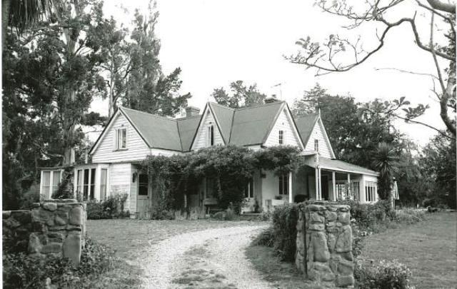
Lease no. 16427 was issued to Herbert Brown (1860-1928) of Mount Thomas Station, Okuku, North Canterbury. Brown’s permanent residence, Mount Thomas Station Homestead, was built in 1857 by his father, John Thomas Brown (1816-1888) and is one of the earliest surviving houses on the Canterbury Plains. Herbert Brown took over the station in 1889 with his new wife, Annie Emily (née Mannering). Together they created a large and attractive garden around the homestead, starting with ferns collected on their West Coast honeymoon. At his funeral in 1928, Brown was remembered as a ‘great home-lover; making it beautiful was his greatest delight, unless it was entertaining his friends there’. The Browns were also Alpine enthusiasts and the decision to secure land at Arthur’s Pass followed a trip to the West Coast via Arthur’s Pass in January 1925.
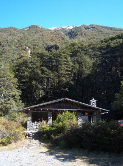
Brown selected a site at the northern end of the township, on the opposite side of the Bealey River from Punchbowl Falls. The site was surveyed in November 1925 and engineer Harvey Maitland Chrystall (1888-1967) was engaged to draw up plans for a holiday home for the Brown family and their friends. Chrystall, a close friend of the Browns, produced plans for a ‘Mountain Hut’ in January 1926. Construction commenced immediately, conducted by a Christchurch stonemason and Henry Warburton Fitzgerald (Gerald) Hamilton, later Brown’s son-in-law. Other friends and family members assisted in the construction, including Annie Brown’s brother George Edward (Guy) Mannering (1862-1947), a renowned mountaineer and co-founder of the New Zealand Alpine Club. The design was based on a Swiss Alpine chalet, reflecting Mrs Brown’s schooling in Switzerland. It was constructed from boulders sourced from the Bealey River, unusual at the time as dwellings in the area were generally built from timber or corrugated iron. The use of locally sourced material had practical advantages, avoiding the transportation of cumbersome building materials, though this was not the primary reason for this choice of material.
The deed for the lease was produced on 6 June 1926 granting occupation of one rood 16 perches of land as a house site. The lease was renewed on an annual basis and was subject to the right of the Railway Department to lay a siding on the eastern boundary. Brown died on 18 February 1928, six days after the marriage of Hamilton to Brown’s daughter Nancy. The lease passed to the trustees of Brown’s estate, Annie Emily Brown and Christchurch accountant Arnaud McKellar. In 1940 Hamilton was appointed as a trustee with Christchurch solicitor John MacDonald.
The chalet, as it was known, was occupied for the first time on 26 October 1926. It soon acquired the name ‘Aniwaniwa’ or rainbow, in reference to the chalet’s view of Punchbowl Falls and the effect of sunlight on the water. The Brown and Hamilton families became highly involved in Arthur’s Pass township and were respected members of the alpine community. Hamilton, with his brother C. G. F. C Hamilton and Kumara vicar the Rev. L .K. Collins, founded the interdenominational Chapel at Arthur’s Pass, designed by Paul Pascoe and consecrated in 1956.
Soon after the completion of the railway to Otira, the Railway Department commenced regular one-day tourist excursions from Christchurch. Passengers were encouraged to disembark at Arthur’s Pass and walk the final ten miles (sixteen kilometres) to Otira Station where the train met them to carry them back to Christchurch. The increase in traffic and tourism around Arthur’s Pass presented concerns for the preservation of the area’s natural values. In 1901 the Government had set apart a Scenic Reserve at the head of the Waimakariri and Otira rivers, on the recommendation of botanist Dr. Leonard Cockayne. Following an intense campaign Arthur’s Pass National Park was formally gazetted as a National Park in 1929.
Most township sections were initially excluded from the National Park, but control of the township area transferred from the administration of the Railway Department to the Arthur’s Pass National Park Board in 1930 in the interest of identifying a body for local administration. The lease area occupied by Aniwaniwa was excluded from the land contained within the National Park and remained administered as railway land. In 1959 the land was allocated to the Department of Lands and Survey (Department of Conservation from 1987) as a conservation area.
The formation of private holiday accommodation on Crown land is common to the experience of ‘baching’ in New Zealand. With earlier precedents in mind, particularly the stated example of Selwyn Huts, the occupation of residence sites at Arthur’s Pass was more closely controlled, to ‘keep any undesirable element out’. Lease conditions stipulated a code for the conduct of occupiers and established standards for maintenance and cleanliness. Plans for improvements were also to be submitted to the District Railway Engineer for approval, however in some instances dwellings were erected on Crown land before leases were formally issued, as was the case in the construction of Aniwaniwa.
The desirability of permanent tenure for sections at Arthur’s Pass was suggested as early as 1928 in response to the some lessees who required freehold title in order to finance improvements on their sites. Aniwaniwa is unusual among these baches for the permanence of the building and the quality of the structure given the absence of secure tenure. This reflects Herbert and Annie Brown’s intention to eventually purchase the land as a long term family asset. The use of a locally sourced material and selection of this particular site away from the railway settlement reflects the owners’ high regard for the natural setting and outlook, and the creation of a building in sympathy with its surroundings. The use of locally-sourced stone also accords with the construction of shelters erected on the Christchurch Port Hills between 1914 and 1917, designed by Samuel Hurst Seager. These shelters were no doubt known to the architect, Harvey Chrystall. While intended to be reminiscent of a Swiss chalet, Aniwaniwa’s low pitch roof, timber gable end and wide eaves are more characteristic of the bungalow style seen in Hurst Seager’s design for the Sign of the Kiwi. In turn, the architectural style of Aniwaniwa can be seen to influence the development of a vernacular building style for later buildings at Arthur’s Pass. The direct influence of this building style is seen in the use of river-stone cladding on the Arthur’s Pass Chapel, and possibly also roadside shelters at Greyneys, Hawdon and Klondyke corner and in later extensions to ‘Oscar’s Haus’.