Maori History
Maori had settlements in Central Otago, associated with early occupation. Six were known on Lake Hawea (Te Taweha o Hawea, Mahaea, O tu Purupuru, Turihuka, Te Taumanu o Taki and Pakituhi) and one near Cromwell (Wairere). The moa-rich area was known for camps where moa were butchered and cooked (for example there were large sites in the Hawksburn and Happy Valley areas, as well as the Nevis Valley), and there were quarries used for stone tools in the region of Tiger Hills and Mount Benger. Closer to Naseby, the swampy plains in the Maniototo provided eels and other food resources. There are no recorded Maori archaeological sites in Naseby.
Naseby
The history of gold mining in Central Otago began with Gabriel Read’s discovery of gold in Gabriel’s Gully, near present-day Lawrence, in 1861. The following year Hartley and Reilly left this gully and travelled further into Central Otago. They spent the winter prospecting in the now-flooded Clutha Gorge between present day Clyde and Cromwell, finding enough gold in the area to travel back to Dunedin and lodge 87 pounds with the Gold Receiver. Gold was quickly discovered in other parts of the region, including places such as Hogburn (renamed Naseby in 1874).
There were an estimated 78 goldfields in Central Otago, boom towns sprung up to service the gold diggings, and disappeared just as quickly as the gold returns for the itinerant miners. Little remains of these places. Historian John Angus writes ‘[w]hen the miners decamped so too did the commercial section of many of the early towns. This pattern was repeated many times, often at remote locations in Central Otago. But some settlements remained, undergoing a sort of metamorphosis to become service centres for the subsequent stages of more stable mining.’
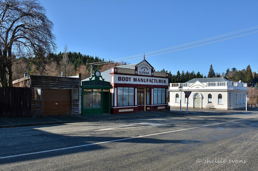
Towns developed haphazardly. Historian John Angus writes that gold mining towns were often an ‘incongruous jumble of handsome stone hotels and public buildings, ornate shop facades often masking bare corrugated iron sides, and ramshackle tin sheds.’ These were often ‘frontier towns’: ‘hotels, illicit sly-grog shops, gambling booths and what Europeans called the ‘opium dens’ of the Chinese. Over the towns there often remained an air of impermanence.’ Naseby was typical of impermanent impromptu development.
This haphazard development was particularly true for Hogburn. The site of the Mt Ida goldfields and the associated township was originally part of a depasturing license, Run 204, called the Sowburn. After the discovery of gold the Otago Provincial Council cancelled the license and proclaimed the Mt. Ida Goldfield. While the original canvas town was set up in the Hogburn Gully, when the official town of Naseby was surveyed it was situated at the mouth of the gully, about a kilometre from the original location. The nascent town was built largely of iron and canvas structures. The suggestion of a new location resulted in angry outbursts and a memorial signed by 350 miners and business people protesting the injustice of such a decision. Businessmen protested that their ability to carry on their trade was dependent on being located near the customers, and there were 150 storekeepers in the existing township, and only 40 allotments surveyed in for businesses in the new survey, let alone that the ground under the new town had not been worked and was likely to be auriferous. Despite objections the town was established in the new location.
The town of Naseby grew steadily with the fortunes of its gold miner population during the 1860s and 1870s. Even in these early years Naseby was seen as the quintessential goldfields town. A correspondent for the Timaru Herald wrote in 1874 that it was ‘one of best specimens, I should say, of a goldfield town; on all sides, in the streets themselves, round the very church which is perched up on a bit of ground only just preserved sacred from the pick and shovel, there are signs of the destructive miner. Acres of land turned over in all directions and the muddy waters of tailraces running down the main thoroughfares, present altogether a curious picture, not the less odd by the funny collection of the small sheet iron shanties which for the most part make up Naseby.’ There were eighteen public houses at this time. Much ground was worked within the township and had been washed away, reoccupied by residences later. There was a lull in mining in the mid 1870s in the period prior to the building of the Mt Ida Water Race and the Hogburn Sludge Channel.
Government and Administration
In 1852 the British Parliament passed the New Zealand Constitution Act allowing the colony to become basically self-governing in domestic matters (except for ‘native policy’). The Act provided for an elected House of Representatives and an appointed Legislative Council. The Act also provided for provincial governments, with elected councils and superintendents.
Taking over the role of the Otago Association, the first Otago Provincial Council was elected in 1853, with William Cargill (the agent for the New Zealand Company) the first superintendent. The Provincial Council covered all of the South Island south of the Waitaki River (although between 1861 and 1870 Southland Provincial Council managed Southland affairs before rejoining Otago). With the establishment of the Mt Ida electorate in 1870, replacing the Manuherikia electorate, Naseby became the ‘hub of political controversy and enthusiasm.’
The people of Naseby were enthusiastic and public-minded, showing individuality and initiative, creating their own pathways. When the 1865 Municipal Corporations Act came into force, making provision for municipalities to be formed at the request of at least fifty locals, Naseby did not take this up. The people had already formed a Naseby Improvement Committee to provide links with the Provincial Council. They exerted considerable influence, for example facilitating the construction of a head race in the face of a reluctant central administration. The need to have a legal entity finally led to the town being declared a municipality on 13 December 1872. More administrative change was to follow.
The Maniototo County Council
In 1876 the Provincial Government system was abolished (as allowed by the Constitution Act), because system had proved itself inadequate in the face of Sir Julius Vogel’s public works and immigration policy. The General Government hastily passed the Counties Act to provide an administrative system to replace it. The Act divided the country into sixty three Counties.
Maniototo County covered a large and isolated area, virtually the same as the Mt Ida Goldfields District, and the Mt Ida Electorate of 1870. The County was all mountainous except where it followed the Lauder Creek. It stretched from the St Bathans Range in the north to the Lammerlaws in the south, bounded by Rough Ridge, the Lammermoors and the Rock and Pillars on the east. By the 1870s there were some rough roads and many small settlments in the hills. The population was around 3,500 Europeans and 250 Chinese. Naseby was by far the biggest town. The main settlements were Upper Kyeburn, Hyde, Hamiltons, Sowburn, Serpentine, Hills Creek, St Bathans and Cambrians.
A Maniototo County Council was elected. The elected councillors, meeting for the first time on 4 January 1877, had ‘little knowledge of the scope of their work or of the funds available, and were under considerable pressure not to constitute’, especially given the existence of the Naseby Municipal Council. The first councillors were John Ewing and Robert G. Brown for St Bathans, Adam Rolland for Ida Burn, John Shannon and John Stuart for Mt Ida, William Williamson for Kyeburn, John Laverty for Hyde, Thomas Foster for Puketoi, and Robert McGregor Turnbull for Serpentine. Hugh Wilson became county clerk, holding the position for forty eight years, making him a central figure in the history of the Council. District engineer Richard Browne became County engineer. Despite the opposition, on 1 May 1877 the Maniototo County Council was constituted.
Adam Rolland designed two versions of a seal for the Council, each bearing the correctly spelled ‘Maniatoto’ (according to Cowan, meaning ‘Plain of Blood’). When these were sent to Dunedin for copying, the firm misspelled the name, rendering it ‘Maniototo’, which it has remained since.
The first County chair was Adam Rolland who took up the position in 1877. He was the son of the Honourable James Rolland, a Scottish lawyer, who had arrived in Otago in 1859 and took up the Blackstone Hill run in 1862. In 1865 he gained a seat on the Legislative Council. Adam took over the run in 1866 when his father returned to Scotland. Roland returned to his Scottish roots in 1881.
The County Council also had other well known personalities, the most well known among them being M.J. Scobie Mackenzie (1845-1901). Mackenzie was a well known runholder in Australia, and was approached by Donald Maclean in 1870 to manage the New Zealand Company’s Deepdell Station in Otago. He purchased Kyeburn Station in 1875 and entered local politics. He was County Chairman in 1883, and elected to the House of Representatives in the Mt Ida seat in 1884, holding it until 1893. Despite his pastoralist leanings he had wide support and was ‘immensely popular.’
St Bathans mine manager John Ewing was also one of the key figures in Central Otago as a whole. He was manager of the Scandinavian Water Race Company, and probably the largest employer of labour on the goldfields. He initiated most of the improvements made in hydraulic sluicing and elevating and was very active in public affairs. He remained on the Council for twenty years.
Richard Browne was a key figure in the Maniototo County Council. Browne was born in Norwich, England. He came to New Zealand about 1863, working under the Dunedin City Engineer. In 1867 he was employed in early investigations on the establishment of rail services in the south. Browne, who had come to the Maniototo to supervise the construction of the lengthy Mt Ida water race, while also acting as engineer for Waikouaiti County Council and district engineer, negotiated a £250 per annum salary. Browne, who also became an authorised surveyor in 1877, started in his new position in June 1877, and held it till his death on 27 August 1907 at Naseby.
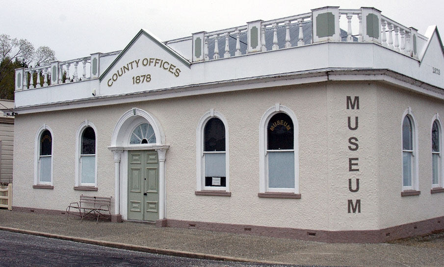
Browne drew up plans and specifications for the new Council Offices. The Council purchased the site on the corner of Leven and Earne Streets for £220. The Mount Ida Chronicle reports that this land was originally the site of Kilgour’s Union, then the Old Victorian Hotel. The Council purchased the land from owner Mr Millar. Despite a request from the council that the building costs were not to exceed £600, the tender of George Stephens for £790 was accepted. Construction began in January 1878 and by August of that year the building was complete. The councillors were pleased with Browne’s design and voted him a £20 bonus. One hundred pounds were allocated toward furnishing the Offices.
Builder George Stephens was also a notable figure. He was involved in many construction projects in the Maniototo. He built the bridge at Hyde in 1879 and also the Naseby Courthouse, as well as being involved in mining construction work at Naseby.
At first the Maniototo County Council functioned mainly as a Roads Board. As Councils became more established more responsibilities were delegated to them by the central government. As an elected body the Council was concerned with issues such as railways and land settlement (particularly the tensions between run holders and those desiring closer settlement), and the relative importance of the rival towns of Naseby and Ranfurly.
The County Council was the focus of administration for its district. Its first efforts were in road and bridge building, and at water works. From 1882 the council took over the forestry reserve in White Sow Valley. The Council encouraged economic development, particularly prospecting, setting up a special committee to provide grants for hopeful miners. They lobbied central government on matters of concern to miners, and also on the establishment of the Central Otago Railway in the 1870s, an issue of huge import to all Central Otago residents, and ironically as will be seen later, for all Naseby’s enthusiasm, the herald of its demise.
The administrators seem to have been aware of the potential historical status of the Council as early as 1881. In that year the first County Chairman, Mr Rolland, moved that a museum be formed, and that a glass case be purchased to hold specimens.
During the war years they worked to encourage patriotic activities, and to erect appropriate memorials to those who served in wars.
For all this activity and community focus, the landscape of Central Otago was changing by the early decades of the twentieth century. The Central Otago Railway had bypassed Naseby, as had State Highway 8, both routed through nearby Ranfurly. As Naseby’s importance declined, the Maniototo County Council considered relocating its services to the newcomer Ranfurly, as well as hospital services, in 1924. The suggestion lead to a barrage of opposition from Naseby residents, with one resident writing ‘[a] mental is what is required at Ranfurly to house eight or ten advocates who urge the change.’
Not until 1936 did the County Council relocate its services. In 1936, following their final meeting in the Naseby building on 24 July, they moved into their purpose built offices in Ranfurly. Their old building was bought by the Maniototo Early Settlers’ Association for £75.
Historian Janet Cowan write that there was ‘something peculiarly sad about the way an upstart, unattractive town can draw the blood from a romantic gold-mining centre whose whole life has been nourished by enterprise, loyalty and pride of miners and early settlers.’ Written in 1948 this comment illustrates the local rivalries, and also foreshadows the future identity of Naseby as ‘2000 ft above worry level’, a romantic sleepy backwater, something that it has built its reputation on in the harried twenty first century.
Maniototo Early Settlers’ Association
The Maniototo Early Settlers’ Association was formed in mid 1910, providing social and commemorative activities for those locals who met the residency qualifications. Vice President Hugh Wilson and the other members set about collecting the reminiscences which appeared in the jubilee period of 1910-1912, significant first hand records of the early life of the town.
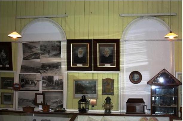
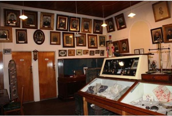
The establishment of a museum was a way for members of the association to play a role in shaping ‘historical memory’ as a museum theorist has stated. Collections, especially at a regional or local level provide evidence of ‘history making taking place.’ Amiria Henare writes that regional history museums and heritage sites are part of ‘cultural landscapes’ and provide evidence of how history is constructed. In this way the Maniototo Early Settlers Museum is part of ‘Pakeha folk history’, providing ‘rescue and salvage’ for a way of life now forgotten. The museum, its collection and displays are artifacts in themselves providing character of the place, telling a story of what the self identified ‘early settlers’ saw as important and creating a narrative of Naseby’s past.
In 1936, following the relocation of the Council, the Association acquired the former County Offices and the Association changed its focus, now working on developing a museum, though the social activities remained important. The Association endeavoured to ‘build up and house a collection of relics, photographs, writings and verse appertaining to the short to the early history of the Maniototo.’ In 1961, at the same time as the Association became an incorporated society, they also acquired properties on Earne Street, building a gig shed on that land.
In 1954 the former County Council building underwent an upgrade. Parts of it were repiled and levelled. In 1958 the two street frontages were roughcast, losing much of the original detailing. Despite these works by the mid 1970s the building was in a poor state of repair, and the Association were advised not to spend further money on the structure, and were considering relocating to another site. The costs of rebuilding and/or relocating were found to be prohibitive so a building programme was undertaken instead. In 1978 a concrete block addition was built by P. Choate, to provide storage for the museum. In 1982 there were further works. The decayed flooring was replaced with concrete. The building was partly reroofed in 1993. In 1995 the numbers of balustrades on the parapet were reduced and part of the parapet rebuilt in cement board.
The Museum is part of the social infrastructure of the small settlement, with the town’s heritage a focus of local community identity and an essential element in the perception of the town as a ‘special place.’
In 2010 the former County Council Offices remains the home of the Maniototo Early Settlers’ Association Museum, whose collection includes household and personal items from early settlers, as well as early newspapers and local records, and where the mode of display with its wooden cases, framed photographs and hand written labels provide a glimpse into the minds of Naseby’s early settlers.