

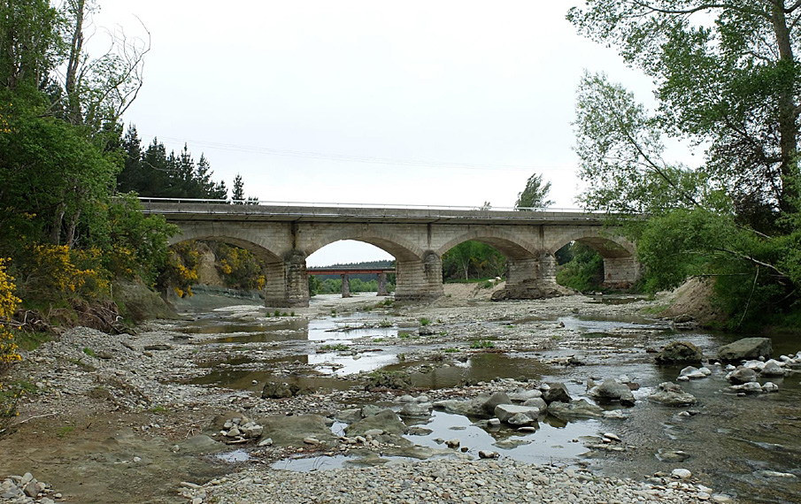
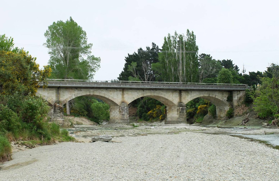
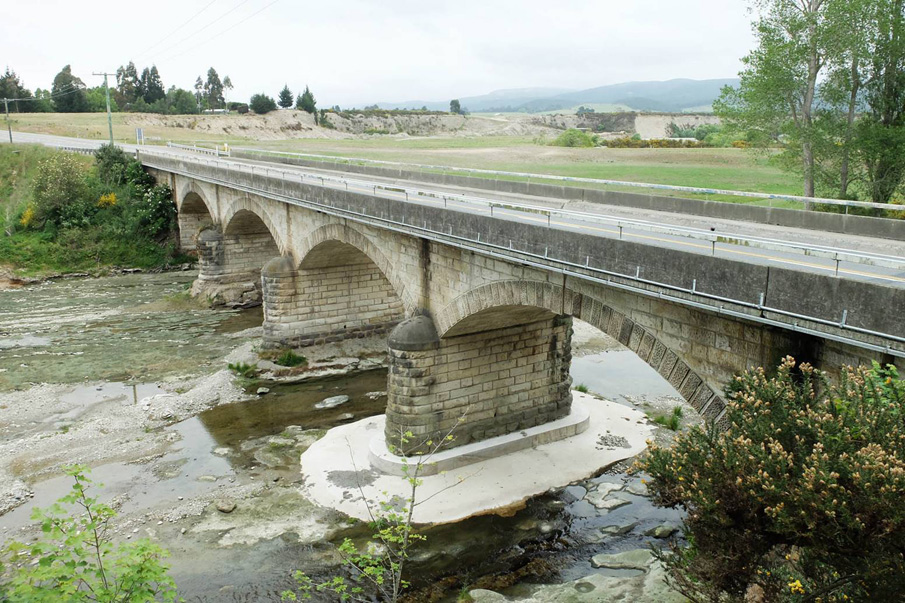
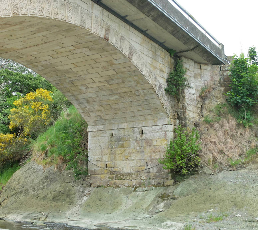
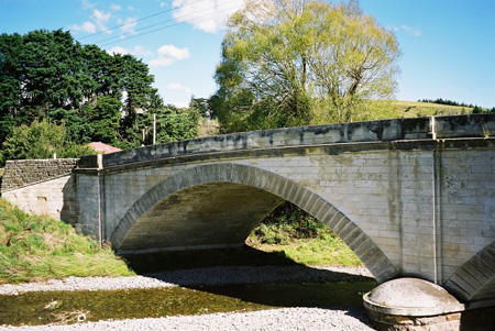
The Waianakarua River Road Bridge (South Branch) is situated on State Highway 1 between Hampden and Ōamaru, and was completed in 1869. It is the first of two bridges spanning the river that were designed by the Otago Provincial Engineer, John Turnbull Thomson (1821-1884). The bridge is historically significant for its connection with Thomson who was responsible for the surveying of Otago and for designing many towns, roads and bridges leading from Dunedin. Significantly this is the oldest bridge in use on the State Highway 1 system, and was constructed of locally quarried Kakanui stone; the quarry was part of Totara Estate. The Waianakarua River was an important resource for Kāi Tahu. It was a kāinga nohoanga and kāinga mahinga kai. To the settlers, the southern branch of the river was known as the Rookery River in the 1860s due to the number of shags that occupied the area, with the upper branch being referred to as the Ōtepopo. The road north was a constant hazard for travellers and coaches who were required to ford streams and rivers. When the ‘Road and Works Tender Contract No. 324’ was opened for the construction of the ‘stone and iron bridge over the south branch of the Otepopo River’ in July 1868, it was welcomed. The bridge was built on substantial rusticated bluestone piers surmounting footings of dolorite. Each of the four arches of the bridge span 12.8 metres and are built using dressed stone (ashlar) interspersed with rough-hewn blocks. The wedge shaped stones of the arches (voussoirs) were carved with a vermiculated finish. The parapet can be seen in Thomson’s watercolour of the bridge 1870. . The original bridge was only 4.3 metres wide and was considered narrow at the time of building, ‘it is found to be far too narrow, so much so that it appears a matter of impossibility for anything beyond an ordinary dray to pass over without damaging the parapets.’ The Ōamaru stone was considered to be of exceptional quality, and was later endorsed by W.H. Clayton, Colonial Architect who said, ‘the stone from the best Kakanui quarries is superior to any other building stone I have met with in the Colonies during a practice of twenty years.’ By January 1869 construction of the bridge was deemed to be making good progress and in May the piers and buttresses were nearly ready and the bridge was described as being ‘the finest stone bridge anywhere this side of Dunedin.’ After the completion of the bridge, it took a further year before the approaches were remedied; these had become difficult to navigate due to large rocks and pot holes which impeded passage. In 1962 a new wider reinforced concrete deck was constructed in order to carry modern traffic. This addition was cantilevered from each side of the bridge. The original parapets were removed at this time and metal handrails installed. The original structure beneath this deck remains in good condition, but is invisible from the roadway.
Location
List Entry Information
Overview
Detailed List Entry
Status
Listed
List Entry Status
Historic Place Category 2
Access
Private/No Public Access
List Number
2436
Date Entered
4th April 1983
Date of Effect
4th April 1983
City/District Council
Waitaki District
Region
Otago Region
Extent of List Entry
Extent includes part of the land described as Legal Road and part of the land described as Legal River, Otago Land District and the structure known as Waianakarua River Road Bridge (South Branch) thereon. Refer to the extent map tabled at the Board meeting on 27 June 2019.
Legal description
Legal Road; Legal River, Otago Land District
Stay up to date with Heritage this month
