The discovery and settlement of the Wairarapa region is connected with several prominent figures of New Zealand’s history. Ancestral figures such as Hau-nui-a-nanaia, Kupe, Whatonga, Tara Ika and Toi have all been said to have connections with the region and are responsible for the naming of many of the Wairarapa’s features and places. It has been estimated that Rangitane settled in the region by about the sixteenth century. Marriage links with Rangitane saw a group of Ngati Kahungunu retreat to the Wairarapa in the subsequent century as the result of internal hapu conflicts. The groups cohabitated mostly in the south Wairarapa for a period, but then the Ngati Kahungunu newcomers negotiated several sections of land for themselves. This process was not seamless and instances of conflict continued between the two iwi over the centuries. The next significant period of change in the area was in the early nineteenth century with the progression of Te Rauparaha and others. This ushered in an era when many different iwi, including Ngati Whatua, Ngati Awa, Ngati Toa, Ngati Raukawa, Ngati Tama, and Ngati Mutunga, made advances into the region and some Ngati Kahungunu hapu withdrew.
Several decades later, European incursion into the Wairarapa began after the New Zealand Company’s Port Nicholson settlement was established. Based on the reports of the exploring and surveying parties that the company sent out, the southern Wairarapa became one of the first extensive tracts of land to be occupied by Europeans, although the Crown titles, negotiated by Donald McLean, were not obtained until 1853. However, it took substantially longer for settlement to progress beyond Masterton, which was linked to Wellington by road in 1859. Further incursion was slow because the northern Wairarapa was heavily forested. In particular, the forest north of Mount Bruce was dense with rimu, tawa, matai, maire, kahikatea, and rata, and was known as Forty Mile Bush, which was within the larger Seventy Mile Bush that also encompassed the area as far north as Dannevirke and Norsewood. Maori referred to this forest as Te Tapere Nui o Whatonga (The great forest of Whatonga) and an abundance of birdlife resided there amongst giant ancient trees, some of which were large enough for groups of local Maori to shelter within their trunks.
The forest acted as a significant barrier and therefore, while there was some European settlement in the northern Wairarapa before the late nineteenth century, it was not until roads were extended further and the railway link to Wellington established that the area was opened up for substantive settlement. In preparation for the construction of the railway the government had an active role in the foundation of several places in the Wairarapa and Tararua regions. Towns such as Mauriceville, Eketahuna, Norsewood, and Dannevirke were all initially formed as bases for railway labourers. Part of the preparation for the railway construction included building a road through the district which had progressed by the mid to late 1870s.
This increased, albeit rudimentary, access meant that land sales in the Pahiatua area earnestly began in the early 1880s, although they were initially slow. Pahiatua township was established in 1881 and it differed from most of the other settlements in the area because it was not created by the Crown, instead it resulted from private subdivisions of land. The plan by local European landowners to create Pahiatua was headed by Masterton nurseryman, William Wilson McCardle (1844-1921), who is thought to have named the new township after his friend and local Maori Chief, Koneke Pahiatua. By the mid 1880s local tenacity meant that the burgeoning town of about 500 people had shops, a hotel, and a Road Board. The rapid growth of the town and wider area led to the creation of the Pahiatua County Council in 1888 and the Pahiatua Borough in 1892.
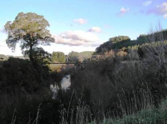
A settler group headed by Henry Sedcole, himself one of the founders of Pahiatua, called the Pahiatua-Puketoi Association was based just east of Pahiatua, and established Kaitawa in the 1880s. The group was relatively diverse with a mix of tradesmen, labourers, professionals, and businessmen. By 1891 the small rural town had its own public school and a store which the post office and Bank of New Zealand operated out of. However, the hopes that many of these early settlers had for the district were not initially realised because the closest bridge across the Tiraumea River was some three miles north. Therefore, local residents must have been overjoyed when a direct access bridge was constructed in the closing years of the nineteenth century. The construction of this first timber bridge was perhaps spurred by an increase in Kaitawa’s population and industry with a creamery being established in 1894.
Being that the railway was one of the main factors behind the settlement of the northern Wairarapa it is not surprising that corresponding dray tracks and roads were also an early consideration. By 1896 the Pahiatua County Council administered 400 miles of roads, and in a region traversed by many different rivers and streams, bridges were soon a priority. As the road network developed and settlement spread, bridges were greatly coveted by local communities all over New Zealand. This was primarily because of the hazardous nature of many of the waterways, especially in winter when flooding was frequent. The risk of drowning or injury for both people and horses while trying to ford rivers was great at these times, and at the very least the lack of a bridge could mean serious delays while the traveller waited for the waters to subside. One early twentieth century commentator thought that, because its landscape was crisscrossed with many waterways, Pahiatua County was one of the most bridged areas in New Zealand.
The dairy industry was quickly established around Pahiatua and while early supply was equal to the demand, by the late 1880s it had surpassed it and exporting produce out of the area was essential. This growth also led to the first local dairy factory being founded in 1892. Like elsewhere in the region, dairy farming soon arose in Kaitawa and by 1909 the area had its own cheese factory, which had developed from the smaller creamery created in 1894. The railway was essential to the local economy in general, but when it was established in the closing years of the nineteenth century it became particularly important to the dairy industry which relied on efficient transport for its perishable product.
Many of the initial bridges in the north Wairarapa were in need of replacement by the mid to late 1920s, like the timber structure leading to Kaitawa. One of the first to be replaced was the highway bridge at Mangatainoka in 1927, and which became the first concrete pier bridge in Pahiatua County. The construction of bridges was generally among the most expensive costs facing local councils at time, and therefore one would assume that replacing existing bridges would be among the first things to be placed on hold when the Great Depression began to affect the New Zealand economy. However, despite the tough times the Council deliberately pushed on with its comprehensive programme of replacements around the Pahiatua area because of the intrinsic importance of bridges to the community and the fragile economy. The value of good bridges was demonstrated by the fact that in a time when wages were being reduced, the County Council actually increased its Bridge Rate in order to progress essential bridge construction, in particular the replacement of the bridge at Kaitawa.
The structural integrity of the existing timber Kaitawa Bridge was sufficiently degraded by the late 1920s that it was identified as a priority structure for replacement. It was feared that the failure of the bridge was imminent which would be devastating for the large local dairy industry in particular, since the late nineteenth century structure was the area’s main access point and because it was essential to the comings and goings of the Kaitawa Dairy Factory and its suppliers. It was stated that there was:
‘…a real danger however, that owing to the condition of the present bridge, it may collapse under the strain imposed by large mobs of cattle passing over it. When I point out that the bridge is somewhere about 60 feet from water level, it can be well imagined what the loss in valuable stock would be, besides the consequent dislocation of traffic and the holding up of farming operations.’
This emphasis on the welfare of cattle and the dairy industry is indicative of its importance locally, especially when it is considered that this letter to the Minister of Public Works from the Pahiatua County Clerk makes no mention of the hazard to humans and potential casualties which could result from the bridge collapsing.
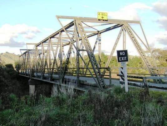
The new Kaitawa Bridge was eventually completed in 1932, and was unusual amongst many of the other bridges in the region constructed during that period because of its steel truss, rather than reinforced concrete, construction. Indeed, in early 1929 the County Council asked the bridge’s engineers, Messrs Seaton, Sladden and Pavitt, to investigate constructing it in reinforced concrete. It is unclear why the steel and concrete option was eventually favoured, although it was probably a matter of cost because the estimates for the truss bridge were almost £1000 cheaper than a reinforced concrete equivalent.
The successful tender for the construction project, which included dismantling the old bridge and realigning the road, was confirmed in January 1931. Mr F. H. Bastin was to undertake the construction in partnership with William Cable’s ironfounders company, based in Wellington. However, the venture was one of the casualties of the devastating Hawke’s Bay earthquake which struck only a few days after Bastin’s successful tender was announced. Not only did Bastin suffer severe losses to his own Hastings property, but his backers, F. G. Smith and Co., were also badly hit through damage and the head of the firm was actually killed in the earthquake. Sympathetic to this unforeseen situation the Council let Bastin continue without his surety. However, due to financial considerations eventually the contract was transferred to R. H. Bird of Hunterville. The completed bridge was inspected and final payments made one year later in February 1932.
The Kaitawa Bridge continued to be a vital link for the Kaitawa district throughout the twentieth century despite it being only wide enough to allow one-way vehicle traffic. It seems that by the late 1970s the structure and steelwork was showing its age and some unspecified repairs involving welding were undertaken in 1978. Despite only directly servicing approximately 20 households and the structure being classed as ‘a lightly trafficked rural bridge,’ it was still a vital link for the community and, as is demonstrated by the next project at the bridge, its history remained closely interwoven with local farming.
In 1985 it was decided that it was necessary to undertake a repair and strengthening project at Kaitawa Bridge due to damage sustained through large stock trucks striking the portal bracing on each end of the through trusses as they passed over the bridge. Because this bracing was below regulation height it was recommended that it be removed, however, because the portal bracing was important to the stability of the truss it was vital to transfer the lateral loads from the top chords of the bridge through to the base of the truss in another manner. This was achieved through projecting external portal bracing outwards and down in a triangle shape. The repairs and alterations to the bridge were undertaken in just over a month during 1986 by A. G. Winn, a Pahiatua engineering firm, for a contract price of $18,500, which also included sandblasting and painting the steelwork.