Detail Of Assessed Criteria
This historic place was registered under the Historic Places Act 1993. The following text is from the original Historic Place Assessment Under Section 23 Criteria report considered by the NZHPT Board at the time of registration.
(a) The extent to which the place reflects important or representative aspects of New Zealand history:
Last century roads and bridges played an important part in the history of New Zealand's development. The country's rugged terrain and its numerous rivers made the provision of bridges essential for if extractive industries such as mining and forestry were to prosper. Earlier coal had been carried across the Grey River in barges, but the completion of this bridge enabled the railway line to transport coal quickly and efficiently down to the Greymouth wharf, where it was loaded into steamers. Greymouth was a smaller export port than Westport, but the Grey Valley was nevertheless an important coal producer and the mines served by this bridge were well-known to coal consumers.
(b) The association of the place with events, persons, or ideas of importance in New Zealand history:
Events:
The principal incident in the history of the bridge was its collapse early one morning in July 1876 just two days before it was due to be handed over. The materials were salvaged from the river and were incorporated in a slightly modified structure. The Grey River Argus, in a colourful piece dated 22 June 1923, described the subsequent commission of inquiry as 'the finest example of "whitewashing" ever set forth in New Zealand.' The bridge would also have been used during rescue operations for the aftermath of the Brunner mine disaster on 26 March 1896 - an event covered by Brian Wood in his 1996 book Disaster at Brunner.
Persons:
Although the bridge is not known to have been intimately associated with persons of importance to New Zealand history, it was of importance to the social history of these small communities. Indeed, it continues to offer pedestrians access to an important historic site.
Ideas:
Not applicable.
(k) The extent to which the place forms part of a wider historical and cultural heritage complex or historical and cultural landscape:
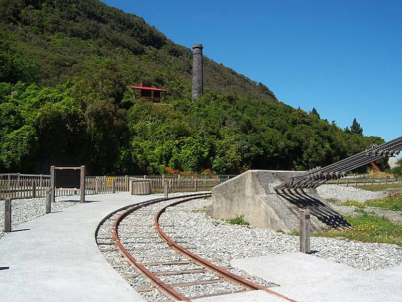
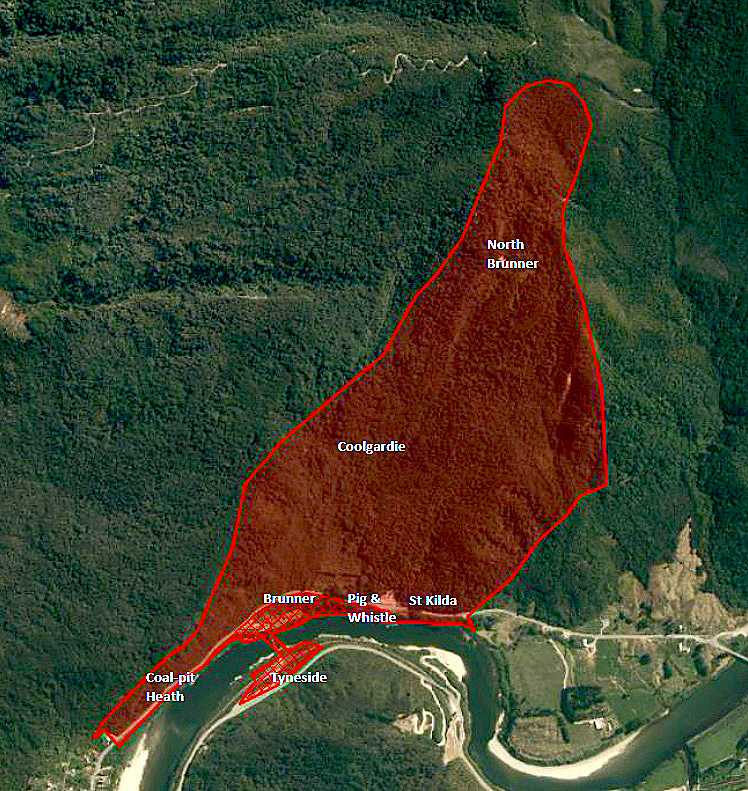
The Brunner Bridge is a key element in the Brunner Industrial Site historic area. As a link in the transport network between mine and wharf, it would also have associations with surviving rail and wharf heritage.
(g) The technical accomplishment or value, or design of the place:
DATE: 1876
ARCHITECT: Public Works department. The responsibility for the design and calculations as to the strength of the bridge at the time of its construction rested primarily with the Engineer-in-Chief, Mr Carruthers, and the District Engineer, C.Y. O'Connor.
STYLE CODE: Victorian Suspension Bridge
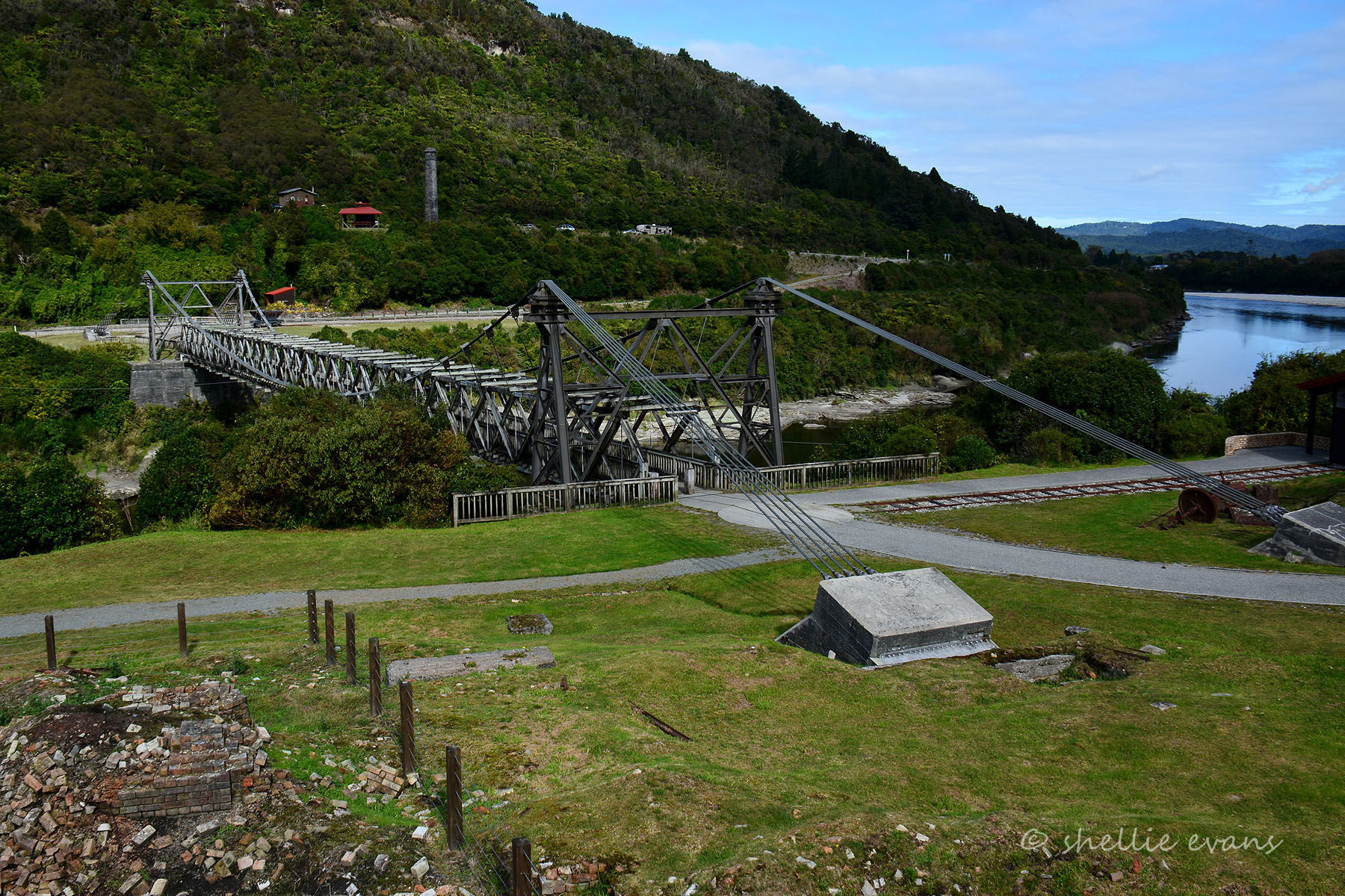
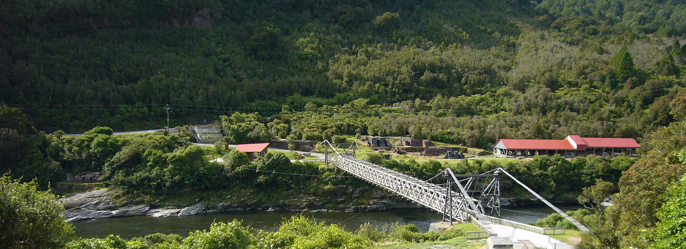
DESIGN: The Brunner bridge was designed and built as a wire cable suspension bridge in 1876. It is one of several suspension bridges all built more or less as contemporaries within a twenty year time frame, and located in central Otago, Southland, and ( in the case of the Brunner bridge) on the West Coast the main inspiration for these bridges came from the American engineering tradition which had to deal with similar problems to New Zealand in terms of coping with difficult terrain and geography, particularly in the American West where a predominance of steep gorges, mountains, wide rivers and valleys resembles much of the New Zealand landscape. In this environment, which is quite different from England, suspension and timber truss bridges were the only practical solution for opening up the land.
The Brunner bridge is actually a contemporary of the Brooklyn Bridge, New York City (c.1876-1883), which is arguably the pioneer suspension bridge type which American and New Zealand bridges were modelled after. The Brunner bridge is also a contemporary of the Kawarau Gorge Suspension Bridge, Central Otago (Cat I, 1878-1880; the Daniel O'Connor Suspension Bridge between Alexandra and Ophir (Cat.I, 1880); the Alexandra Suspension Bridge Piers (Cat.I, 1880); and the Clifden Suspension Bridge, Southland (Cat.I, 1898-1899).
The engineering and architectural quality of the Brunner bridge may be adjudged by the 91 metre (300') span, suspended by galvanised wire cables running over steel towers at each end. This is the same span as the Kawarau Gorge Suspension bridge. originally the towers of the Brunner bridge were made of timber standing on rock filled timber abutments, and it was not until 1969 that these timber towers were
replaced with the present steel ones.
The technique of using wire cables rather than bar iron construction had only been in use for a relatively short time in France and America before being used in New Zealand. It was not part of the British tradition of bridge building - which preferred girder construction - and its appearance on a bridge across the Grey River was therefore an inspired and daring innovation which proved (as it did in the case of the
other bridges mentioned above) to be both aesthetically pleasing in design ,and extremely durable in construction once initial problems with the anchor plates had been ironed out. To illustrate this, the cables of the Brunner Bridge have a lateral curve to the centre of the deck span designed to reduce the swing caused by crosswinds. The strength of this construction is reinforced by a braced timber truss design which gives added stiffening to the deck span.
The bridge therefore appears to be light and graceful by virtue of its method of cable suspension and this, combined with the steel towers and timber trusses, give the bridge and affinity with its former industrial surroundings, as well as a strong visual structural link across the Grey River.
Construction History.
It should be noted that the Brunner bridge to-day has very little of the original bridge remaining in its construction. this stands in contrast with its contemporary, the Kawarau Bridge, which has retained substantial parts of its original structure. The changes that have taken place to the Brunner Bridge are as follows:
1876: Built with timber towers supported on timber abutments filled with
stone. Timber stiffening truss 10 feet high. Two trusses 30 feet in
height. 8 foot wide wooden roadway with a railway in the middle. Five
inch thick cast iron anchor plates.
1876: Collapse of the bridge.
1876-77: Replacement of the 5 inch cast iron anchor plates with box girders or beams 5ft 8in by 18in square, built of half-inch boiler plate well
riveted together.
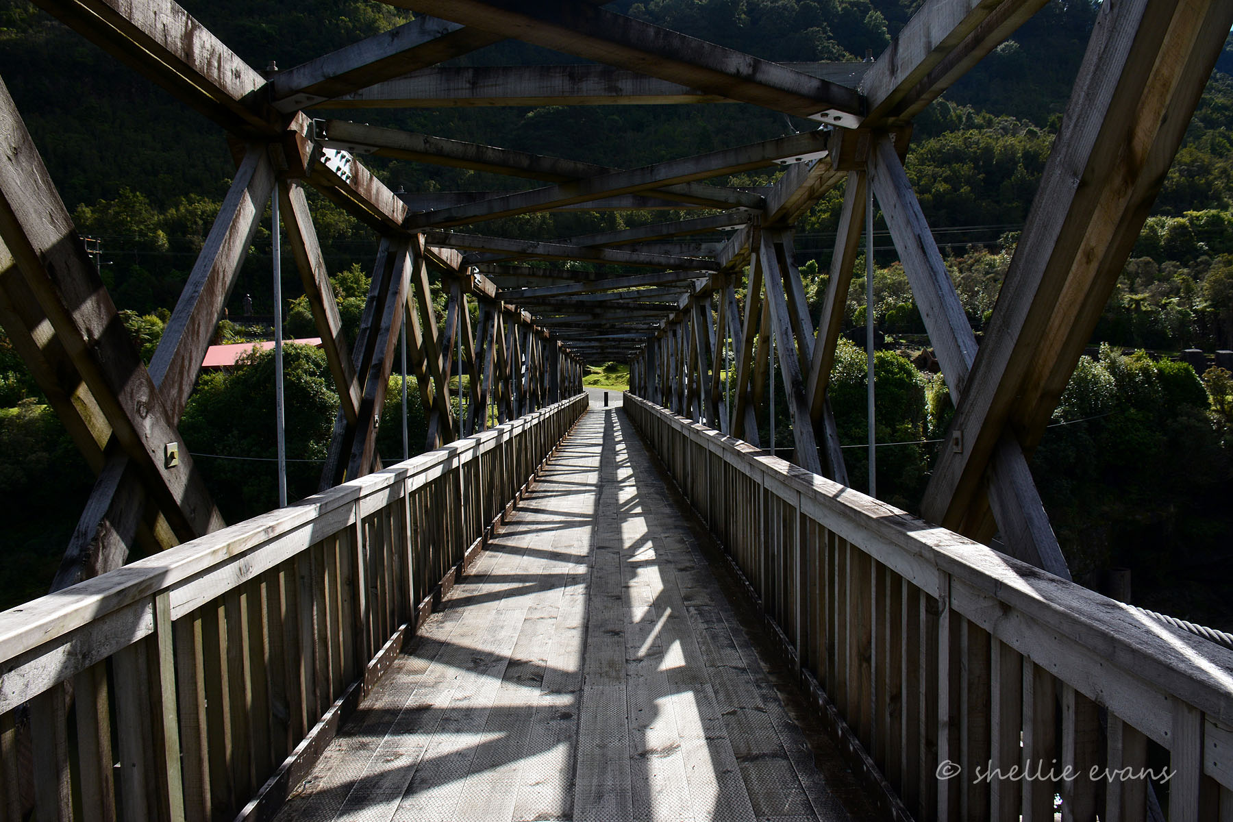
1885: Construction of a footway across the upper chord of the truss.
1921: Footway widened from 2'6" to 4'0".
1921-23: A wire cable broke.
1923: Ownership of the bridge passed over to the Brunner Borough Council by the NZ Railway Corporation.
1927: Bridge considerably rebuilt. Truss span replaced. New cables fitted. Towers strengthened.
1969: Timber trusses and towers replaced with steel.
1978: Closure of the bridge to all traffic other than pedestrian.
1978-97: Some "modifications" ( not specified) including the incorporation of some bailey Bridge parts.
Dimensions as built.
Span: 91.44 metres (300 feet).
Stiffening Truss: 10 feet high.
Trusses: 30 feet high.
Roadway: 8 feet wide.
Footway: 4 feet wide (final width).
(m) Such additional criteria not inconsistent with those in paragraphs (a) to (k):
There are 91 bridges registered by the trust. Of these four are steel cable/truss span suspension bridges of the same type of design as the Brunner Bridge, while a fifth was the Alexandra bridge of which only the stone towers, or piers, now remain after the demolition of the bridge in 1958-9. The additional example in this group not mentioned above is the Arapuni Power Station Suspension Bridge built in 1925-6 (Cat.II).
There is therefore a relative degree of rarity attached to these suspension bridges, particularly for those built in the nineteenth century where construction began in the 1870s. There are only two of these latter bridges, viz., the Kawarau Bridge and the Brunner Bridge.
Comparatively speaking, the Brunner Bridge does not compare with the Category I quality of its two closest contemporaries, the Kawarau bridge and the Daniel O'Connell bridge. Both of these latter bridges have retained their original towers which are of local schist stone. The Kawarau bridge still has its original timber stiffening truss. The Daniel O'Connell bridge has had its timber stiffening truss replaced with a steel one, but in 1905 which makes this alteration 64 years older than the same modification from timber to steel carried out to the Brunner Bridge. In summary, the Brunner bridge is in the same category as the proverbial Washington's axe; the design has remained the same although not all the materials are original. From an engineering point of view however, the design nevertheless remains as having considerable technical interest because it is still a very good example of nineteenth century bridge building engineering of which few examples are left to-day.